Mapping the Recovery Process of Vegetation Growth in the Copper Basin, Tennessee Using Remote Sensing Technology


Abstract
1. Introduction
2. Materials and Methods
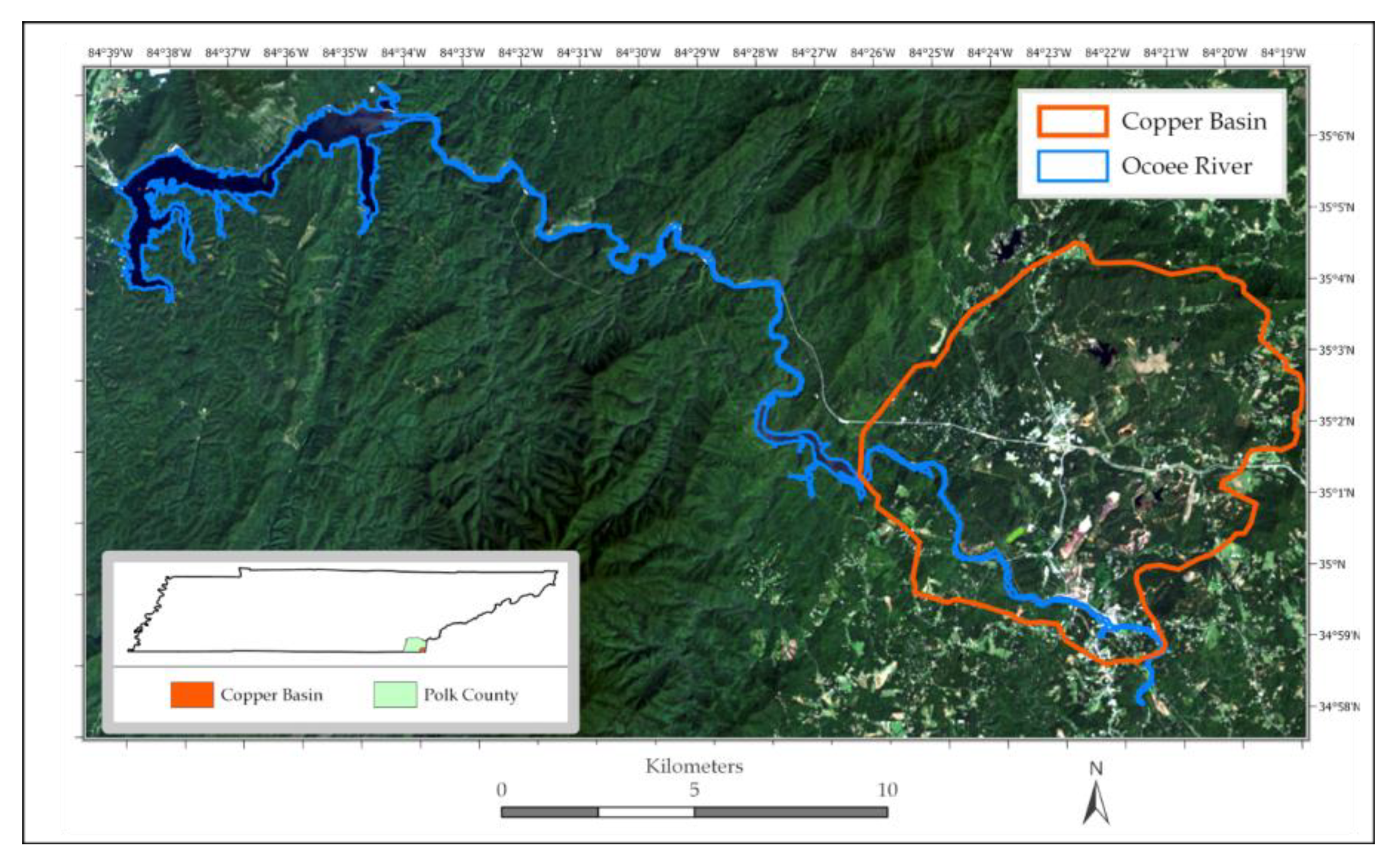
2.1. Study Site
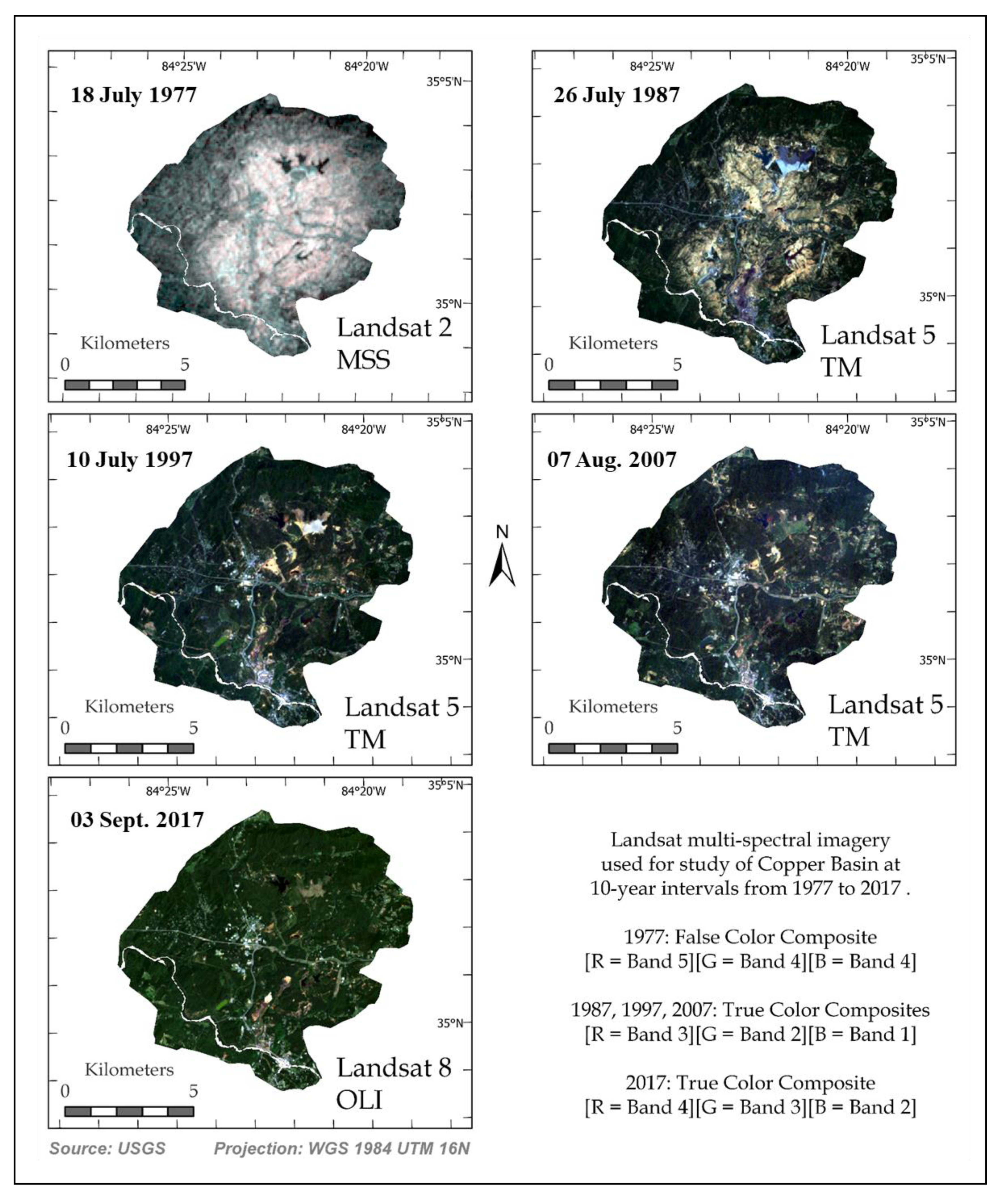
2.2. Data Collection and Processing
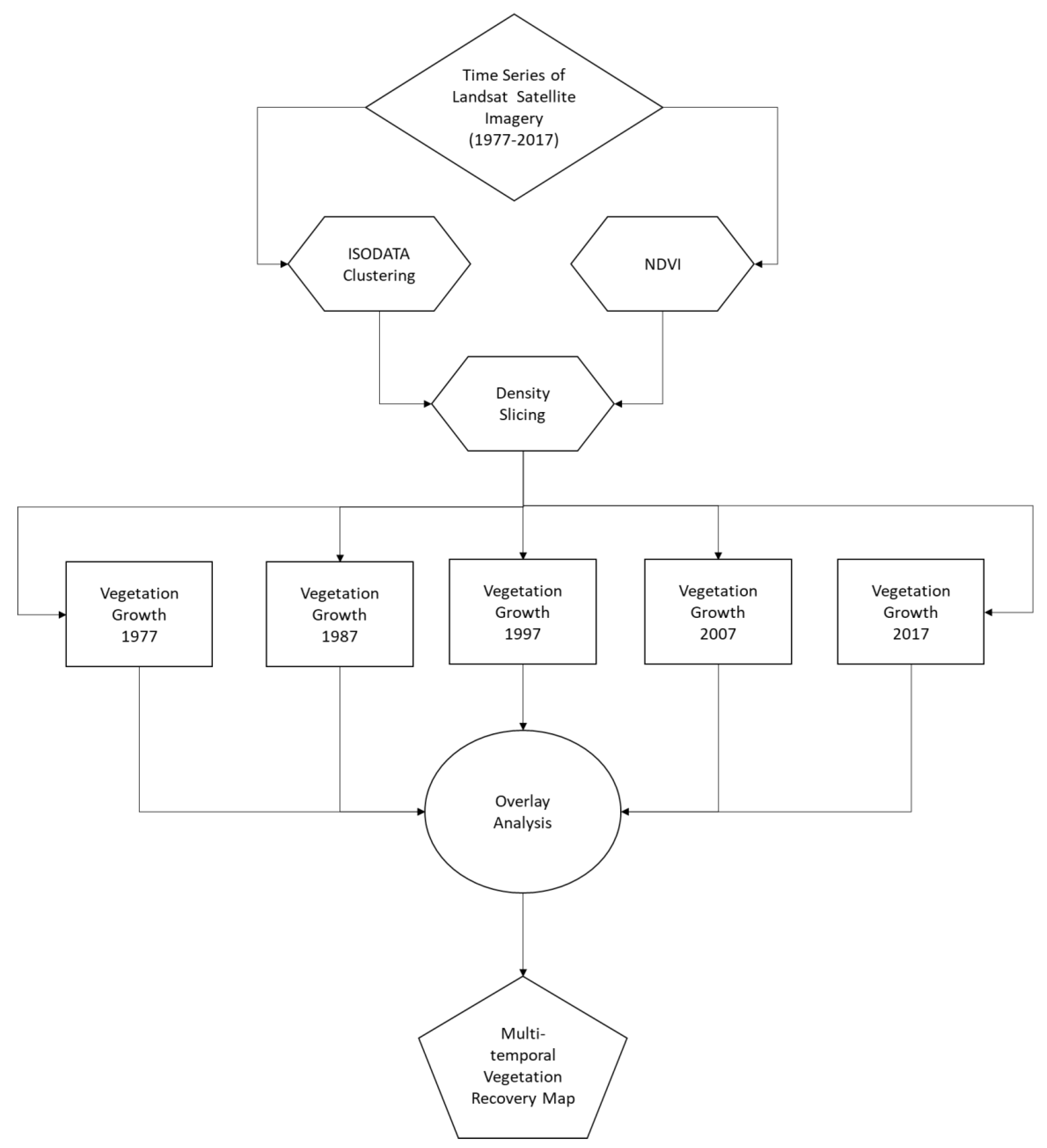
2.3. Digital Image Processing
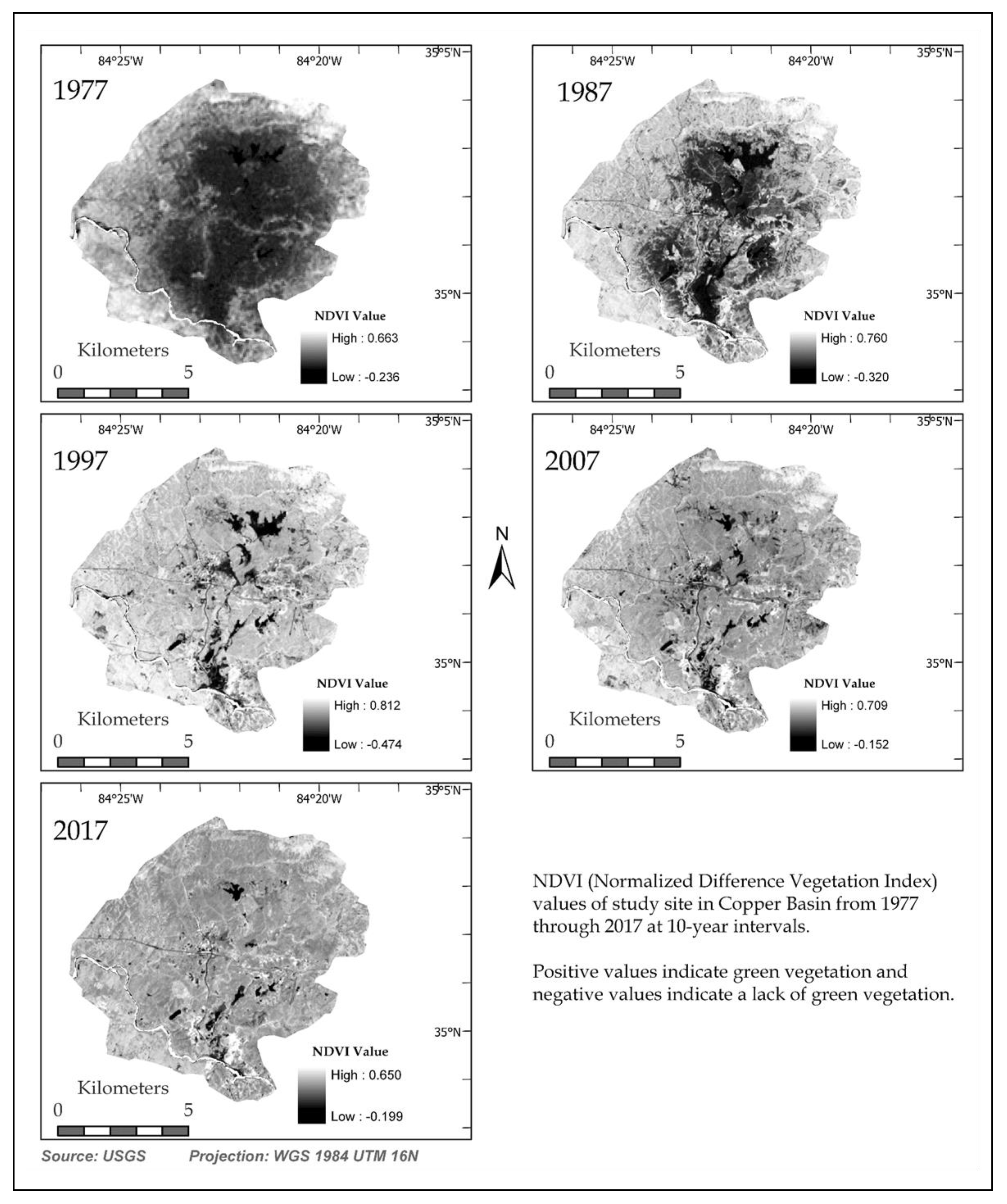
2.4. Analysis of Vegetation
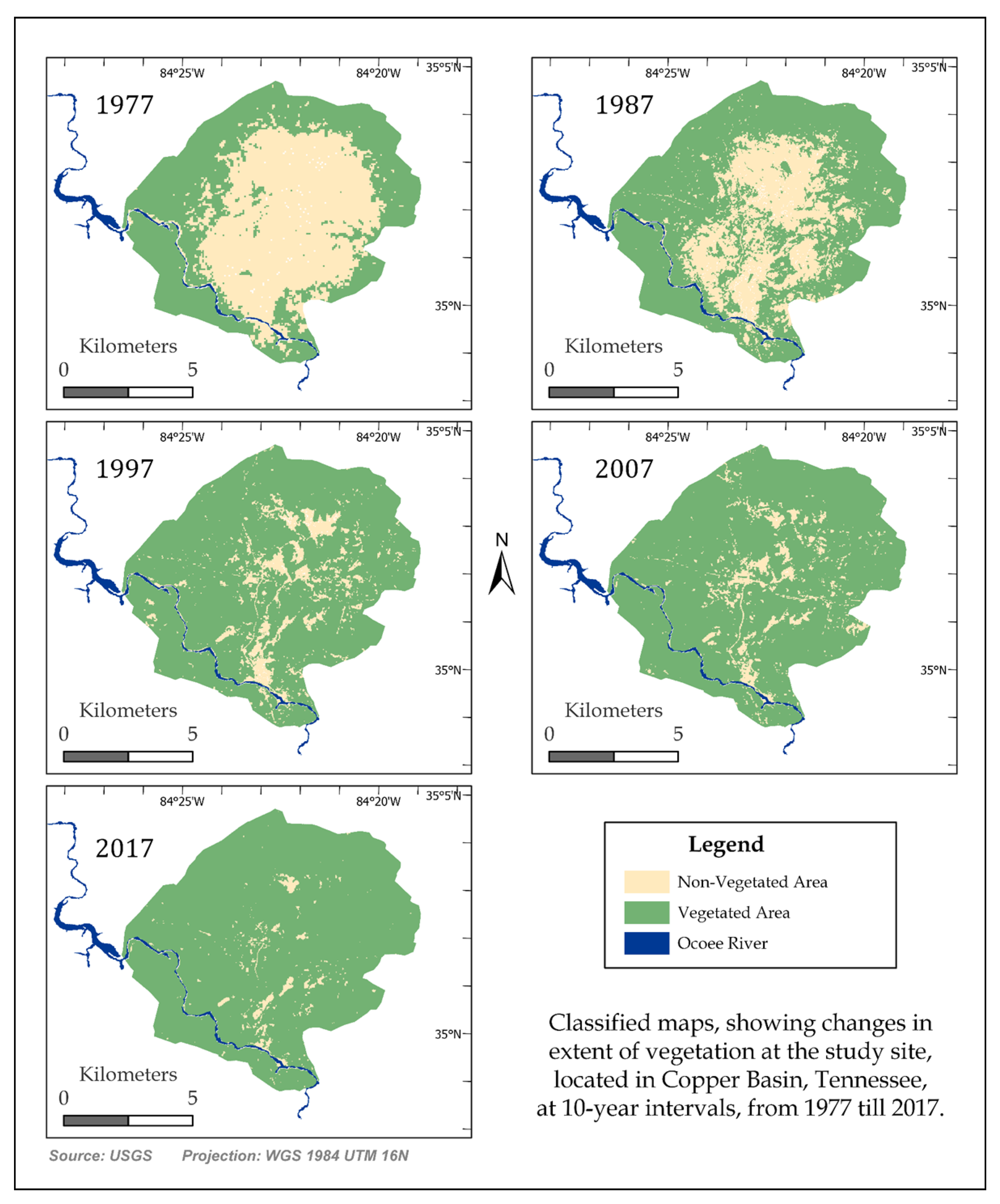
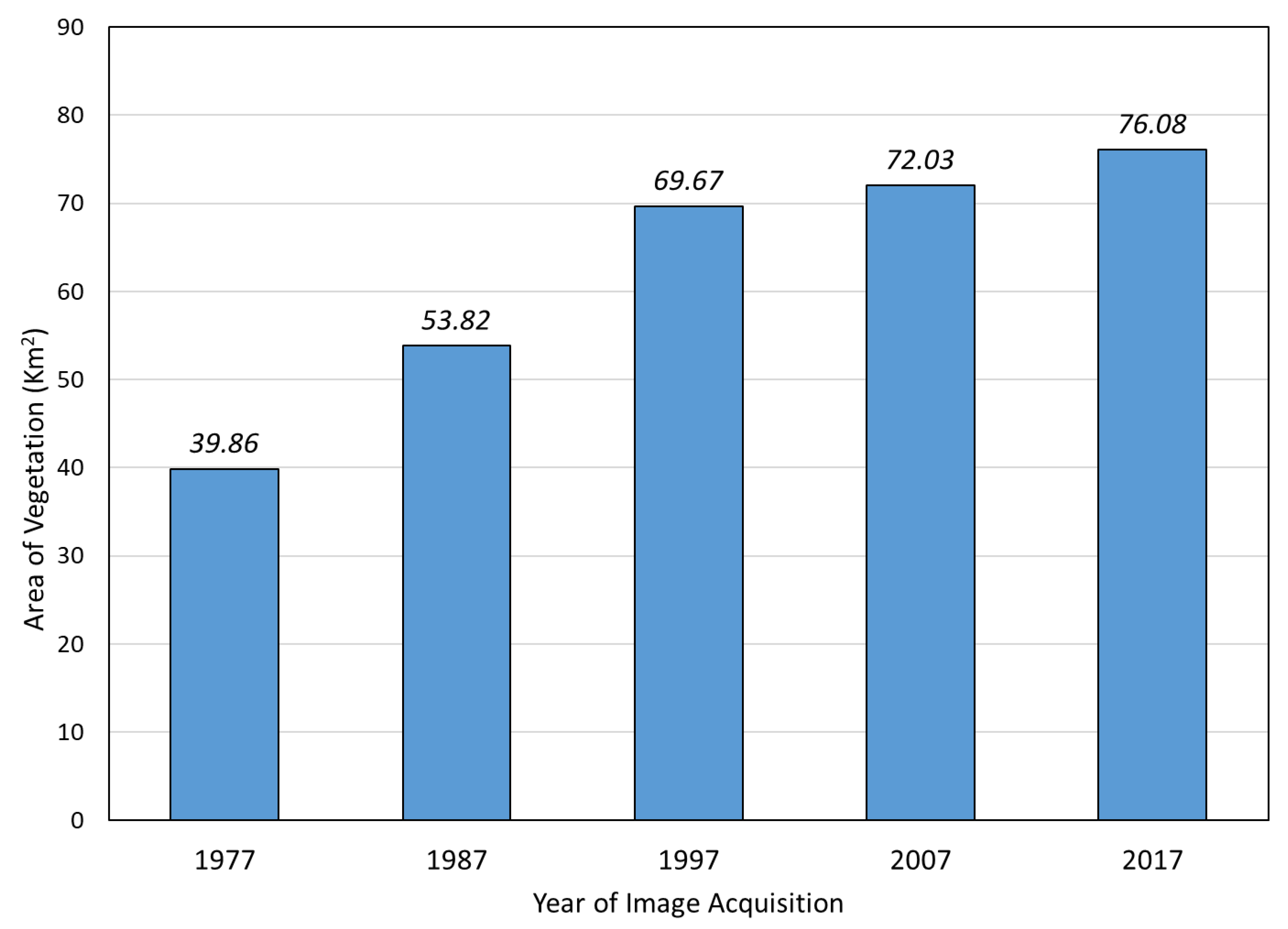
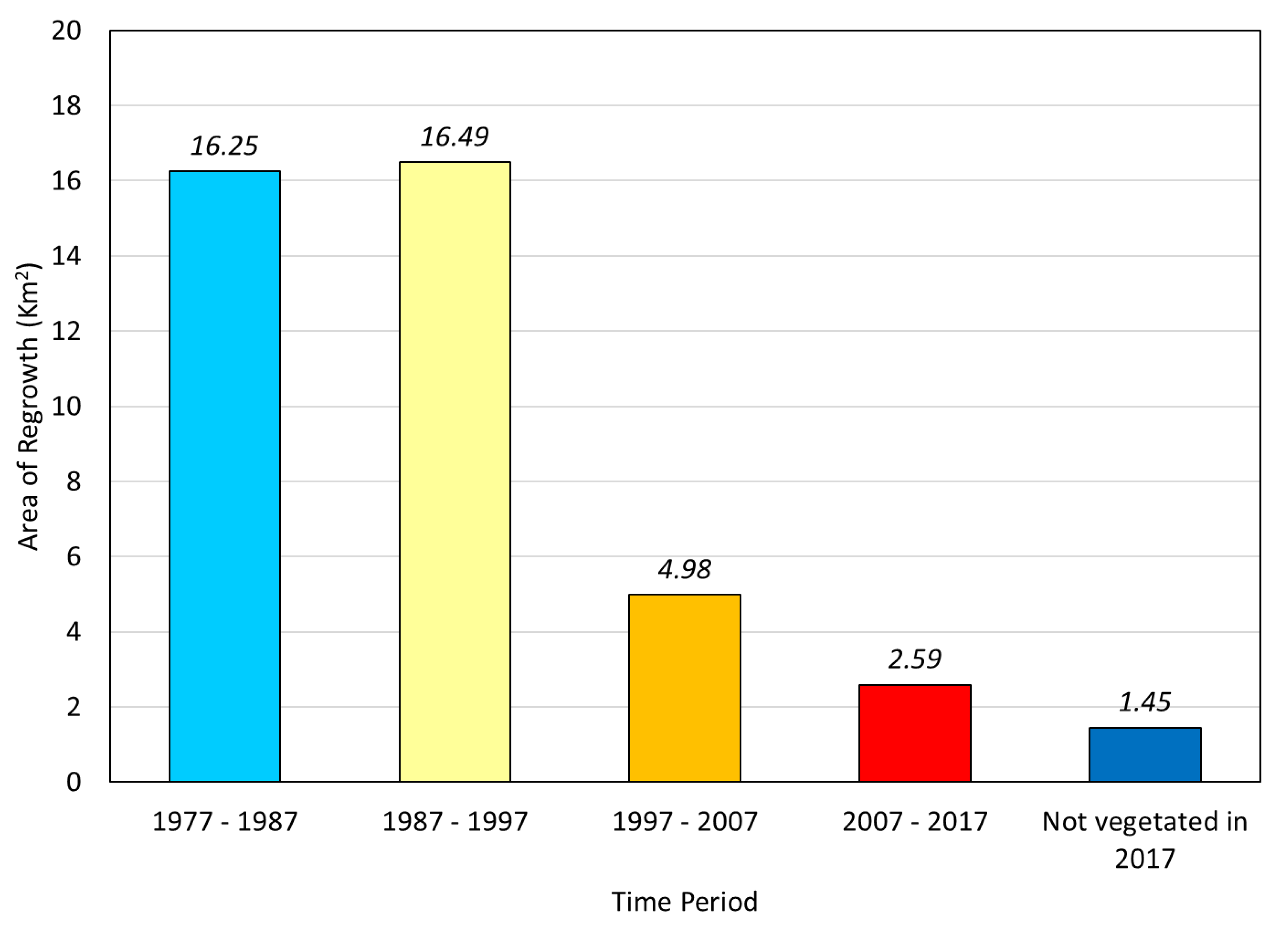
3. Results
4. Accuracy Assessment
5. Discussion and Conclusions
Author Contributions
Funding
Acknowledgments
Conflicts of Interest
References
- Seigworth, K.J. Ducktown—A postwar challenge. Am. For. 1943, 49, 521–523. [Google Scholar]
- Quinn, M.L. The Appalachian Mountains’ Copper Basin and the concept of environmental susceptibility. Environ. Manag. 1991, 15, 79–194. [Google Scholar] [CrossRef]
- Quinn, M.L. Industry and environment in the Appalachian Copper Basin, 1890–1930. Technol. Cult. 1993, 34, 575–612. [Google Scholar] [CrossRef]
- Wolt, J.D. Sulfate retention by acid sulfate-polluted soils in the Copper Basin area of Tennessee. Soil Sci. Soc. Am. J. 1981, 45, 283–287. [Google Scholar] [CrossRef]
- Emmons, W.H.; Laney, F.B. Geology and Ore Deposits of the Ducktown Mining District, Tennessee, United States Geological Survey Professional Paper 139; Government Printing Office: Washington, DC, USA, 1926; pp. 1–159.
- United States Department of Justice, Office of Public Affairs, Press Release 16–485. Available online: https://www.justice.gov/opa/pr/department-justice-and-epa-announce-50-million-settlement-clean-contamination-eastern (accessed on 7 November 2019).
- United States Environmental Protection Agency, Abandoned Mine Lands Innovative Technology Case Study. Available online: https://frtr.gov/costperformance/pdf/20070522_397.pdf (accessed on 8 November 2019).
- Harden, C.; Mathews, L. Rainfall response of degraded soil following reforestation in the Copper Basin, Tennessee, USA. Environ. Manag. 2000, 26, 163–174. [Google Scholar] [CrossRef]
- Tennessee Valley Authority. Available online: https://www.tva.gov/Environment/Environmental-Stewardship/Land-Management/The-Greening-of-Copper-Basin (accessed on 8 November 2019).
- Tennessee Valley Authority. Available online: https://www.tva.gov/About-TVA/Our-History/Built-for-the-People/The-Global-View (accessed on 7 November 2019).
- United States EPA Superfund Site: Copper Basin Mining District, Copperhill, TN. Available online: https://cumulis.epa.gov/supercpad/SiteProfiles/index.cfm?fuseaction=second.Cleanup&id=0406638 (accessed on 8 November 2019).
- Mathews, L.; Harden, C. 150 years of environmental degradation and reclamation in the Copper Basin, Tennessee. Southeast. Geogr. 1999, 39, 1–21. [Google Scholar] [CrossRef]
- Meng, R.; Dennison, P.E.; D’Antonio, C.M.; Moritz, M.A. Remote sensing analysis of vegetation recovery following short-interval fires in southern California shrublands. PLoS ONE 2014, 9, 1–12. [Google Scholar] [CrossRef]
- Shvetsov, E.G.; Kukavskaya, E.A.; Buryak, L.V.; Barrett, K. Assessment of post-fire vegetation recovery in Southern Siberia using remote sensing observations. Environ. Res. Lett. 2019, 14, 1–13. [Google Scholar] [CrossRef]
- Chu, T.; Guo, X. Remote sensing techniques in monitoring post-fire effects and patterns of forest recovery in boreal forest regions: A review. Remote Sens. 2014, 6, 470–520. [Google Scholar] [CrossRef]
- Almeida-Filho, R.; Shimabukuro, Y.E. Digital processing of a Landsat-TM time series for mapping and monitoring degraded areas caused by independent gold miners, Roraima State, Brazilian Amazon. Remote Sens. Environ. 2002, 79, 42–50. [Google Scholar] [CrossRef]
- Yang, Y.; Erskin, P.D.; Lechnerc, A.M.; Mulligan, D.; Zhang, S.; Wang, W. Detecting the dynamics of vegetation disturbance and recovery in surface mining area via Landsat imagery and LandTrendr algorithm. J. Clean. Prod. 2018, 178, 353–362. [Google Scholar] [CrossRef]
- Su, W.; Sun, Z.; Li, D.; Ramsankaran, R.; Zhu, X.; Guo, X. Vegetation recovery monitoring over the waste dump in Haizhou opencast coalmine area, China, during 1975–2000 using NDVI and VF index. J. Indian Soc. Remote Sens. 2009, 37, 631–645. [Google Scholar] [CrossRef]
- Nwadiolo, B.S. Morphological, Chemical, and Mineralogical Properties of Soils and the Effects of Acid Sulfate Weathering in the Copper Basin of Tennessee. Ph.D. Dissertation, University of Tennessee, Knoxville, TN, USA, 1982. [Google Scholar]
- Hursh, C.R. Local Climate in the Copper Basin of Tennessee as Modified by the Removal of Vegetation, Circular 774; U.S. Department of Agriculture: Washington, DC, USA, 1948; pp. 1–38.
- Rouse, J.W.; Haas, R.H.; Schell, J.A.; Deering, D.W. Monitoring vegetation systems in the Great Plains with ERTS. NASA Spec. Publ. 1974, 1, 309–317. [Google Scholar]
- Kriegler, F.; Malila, W.A.; Nalepka, R.F.; Richardson, W. Preprocessing, transformations, and their effects on multispectral recognition. In Proceedings of the Sixth International Symposium on Remote Sensing of Environment, University of Michigan, Ann Arbor, MI, USA, 13–16 October 1969; pp. 97–131. [Google Scholar]
- Hossain, A.; Easson, G. Predicting shallow surficial failures in the Mississippi River levee system using airborne hyperspectral imagery. Geomat. Nat. Hazard. Risk 2012, 3, 55–78. [Google Scholar] [CrossRef]
- Ahmed, M.R.; Hassan, Q.K.; Abdollahi, M.; Gupta, A. Processing of near real time land surface temperature and its application in forecasting forest fire danger conditions. Sensors 2020, 20, 984. [Google Scholar] [CrossRef] [PubMed]
- Boone, R.B.; Galvin, K.A.; Lynn, S.J. Generalizing El Nino effects upon Maasai livestock using hierarchical clusters of vegetation patterns. Photogramm. Eng. Remote Sens. 2000, 66, 737–744. [Google Scholar]
- Hassan, Q.K.; Rahman, K.M. Applicability of remote sensing-based surface temperature regimes in determining the deciduous phenology over boreal forest. J. Plant. Ecol. 2013, 6, 84–91. [Google Scholar] [CrossRef]
- Hassan, Q.K.; Bourque, C.P.-A. Spatial enhancement of MODIS-based images of leaf area index: Application to the boreal forest region of northern Alberta. Remote Sens. 2010, 2, 278–289. [Google Scholar] [CrossRef]
- Jensen, J.R. Introductory Digital Image Processing: A Remote Sensing Perspective, 3rd ed.; Prentice-Hall: Upper Saddle River, NJ, USA, 2004; pp. 1–544. [Google Scholar]
- Ahmed, M.R.; Hassan, Q.K.; Abdollahi, M.; Gupta, A. Introducing a new remote sensing-based model for forecasting forest fire danger conditions at a four-day scale. Remote Sens. 2019, 11, 2101. [Google Scholar] [CrossRef]
- Lillesand, T.M.; Kiefer, R.W. Remote Sensing and Image Interpretation, 4th ed.; John Willey and Sons, Inc.: Hoboken, NJ, USA, 2000; pp. 1–724. [Google Scholar]
- Afrin, S.; Gupta, A.; Farjad, B.; Ahmed, M.R.; Achari, G.; Hassan, Q.K. Development of land-use/land-cover maps using Landsat-8 and MODIS data, and their integration for hydro-ecological applications. Sensors 2019, 19, 4891. [Google Scholar] [CrossRef]
- Hossain, A.; Jia, Y.; Chao, X. Estimation of Manning’s roughness coefficient distribution for hydrodynamic model using remotely sensed land cover features. In Proceedings of the 17th International Conference on Geoinformatics 4 (IEEE), Fairfax, VA, USA, 12–14 August 2009; pp. 1–4. [Google Scholar]
- Hossain, A.; Easson, G. Mapping small reservoirs in semi-arid region using optical and microwave remote sensing. In Proceedings of the 2007 ASPRS Annual Conference, Tampa, FL, USA, 7–11 May 2007. [Google Scholar]
- Campbell, J.B. Introduction to Remote Sensing, 3rd ed.; Taylor and Francis: London, UK, 2002. [Google Scholar]
- Hall, J.; Hossain, A. Mapping urbanization and evaluating its possible impacts on stream water quality in Chattanooga, Tennessee, using GIS and remote sensing. Sustainability 2020, 12, 1980. [Google Scholar] [CrossRef]


| Image Acquisition Date | Satellite Mission | Sensor Type | Spectral Bands | Wavelength (µm) | Spatial Resolution (m) |
|---|---|---|---|---|---|
| 18 July 1977 | Landsat 2 | Multispectral Scanner (MSS) | Green (B4) Red (B5) NIR (B6) | 0.5–0.6 0.6–0.7 0.7–0.8 | 60 |
| 26 July 1987 | Landsat 5 | Thematic Mapper (TM) | Blue (B1) Green (B2) Red (B3) NIR (B4) | 0.45–0.52 0.52–0.60 0.63–0.69 0.76–0.90 | 30 |
| 10 July 1997 | |||||
| 7 August 2007 | |||||
| 3 September 2017 | Landsat 8 | Operational Land Imager (OLI) | Blue (B2) Green (B3) Red (B4) NIR (B5) | 0.45–0.51 0.53–0.59 0.64–0.67 0.85–0.88 | 30 |
| Year | Non-Vegetated Area | Vegetated Areas |
|---|---|---|
| 1977 | −0.236 to 0.254 | 0.255 to 0.663 |
| 1987 | −0.320 to 0.341 | 0.342 to 0.760 |
| 1997 | −0.474 to 0.394 | 0.395 to 0.812 |
| 2007 | −0.151 to 0.331 | 0.332 to 0.709 |
| 2017 | −0.199 to 0.232 | 0.233 to 0.650 |
| Year of Image Acquisition | Area Vegetated (km2) | Area without Vegetation (km2) |
|---|---|---|
| 1977 | 39.86 | 38.48 |
| 1987 | 53.82 | 24.34 |
| 1997 | 69.67 | 8.69 |
| 2007 | 72.03 | 6.49 |
| 2017 | 76.08 | 2.46 |
| Reference Pixels | Classified NDVI Pixels | Total Pixels | |
|---|---|---|---|
| Vegetated Area | Non-Vegetated Area | ||
| Vegetated Area | 50 | 0 | 50 |
| Non-vegetated Area | 4 | 46 | 50 |
| Total | 54 | 46 | 100 |
© 2020 by the authors. Licensee MDPI, Basel, Switzerland. This article is an open access article distributed under the terms and conditions of the Creative Commons Attribution (CC BY) license (http://creativecommons.org/licenses/by/4.0/).
Share and Cite
Blanton, R.; Hossain, A.K.M.A. Mapping the Recovery Process of Vegetation Growth in the Copper Basin, Tennessee Using Remote Sensing Technology. GeoHazards 2020, 1, 31-43. https://doi.org/10.3390/geohazards1010004
Blanton R, Hossain AKMA. Mapping the Recovery Process of Vegetation Growth in the Copper Basin, Tennessee Using Remote Sensing Technology. GeoHazards. 2020; 1(1):31-43. https://doi.org/10.3390/geohazards1010004
Chicago/Turabian StyleBlanton, Richard, and A.K.M. Azad Hossain. 2020. "Mapping the Recovery Process of Vegetation Growth in the Copper Basin, Tennessee Using Remote Sensing Technology" GeoHazards 1, no. 1: 31-43. https://doi.org/10.3390/geohazards1010004
APA StyleBlanton, R., & Hossain, A. K. M. A. (2020). Mapping the Recovery Process of Vegetation Growth in the Copper Basin, Tennessee Using Remote Sensing Technology. GeoHazards, 1(1), 31-43. https://doi.org/10.3390/geohazards1010004