Soil Erosion Spatial Prediction using Digital Soil Mapping and RUSLE methods for Big Sioux River Watershed

 ,
, 
 ,
,
Abstract
:1. Introduction
2. Materials and Methods
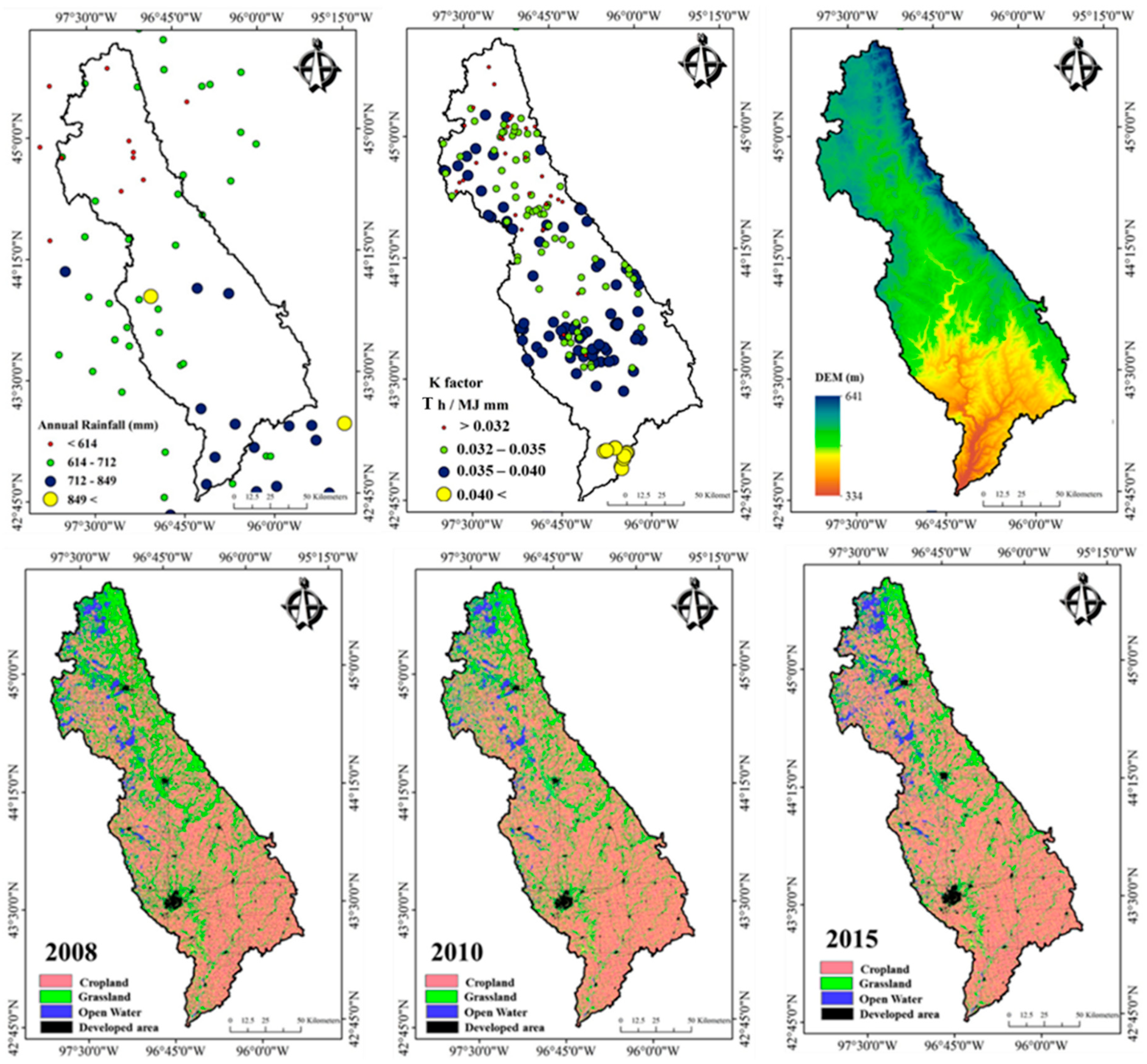
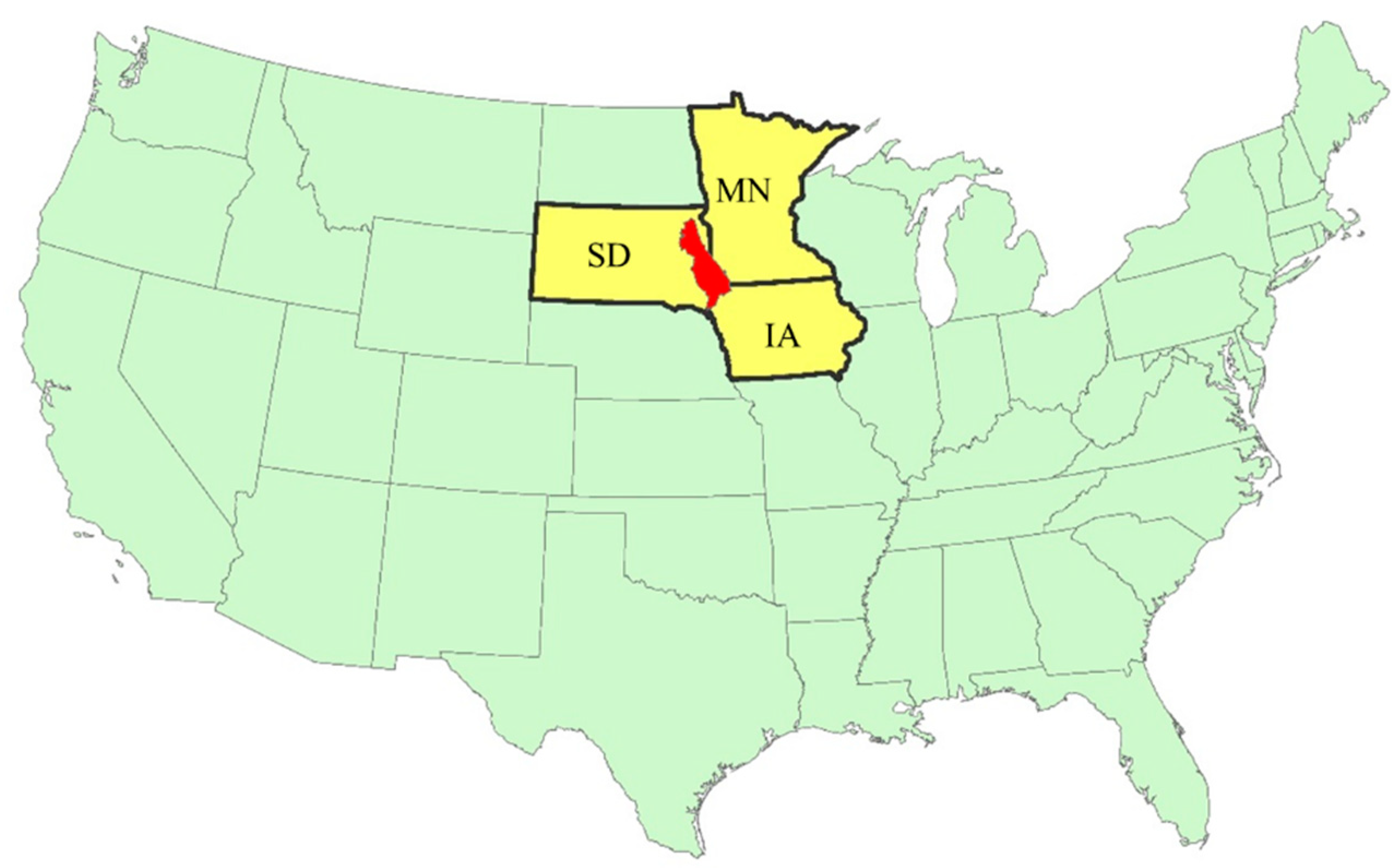
2.1. Study Area
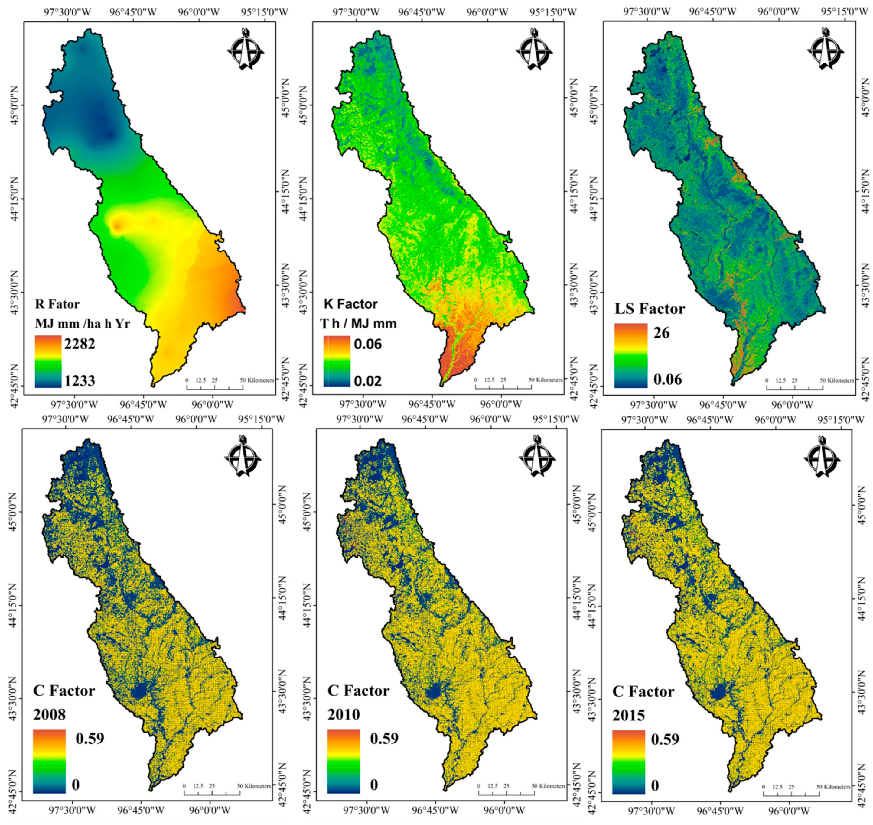
2.2. RUSLE Model Soil Erosion Calculation
2.2.1. Rainfall Erosivity Factor (R)
2.2.2. Soil Erodibility (K)
2.2.3. Topographic Factor (LS)
2.2.4. Crop Management (C)
2.2.5. Conservation Support Practice (P)
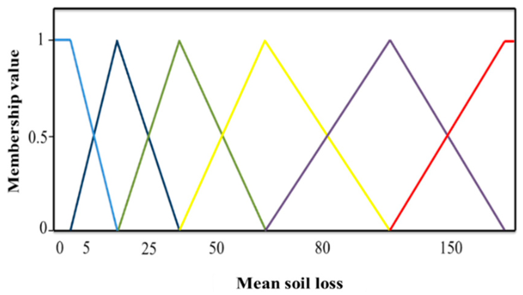
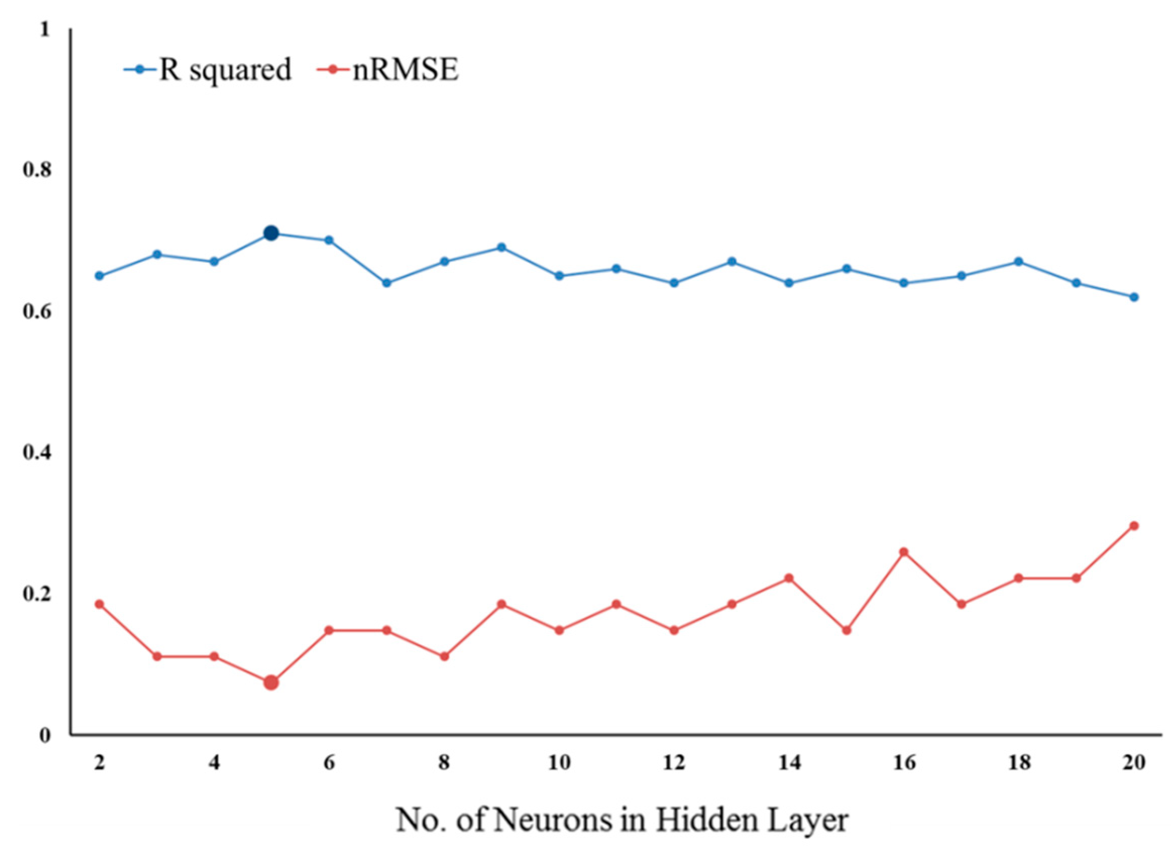
2.3. Soil Erosion Risk Assessment
3. Results and Discussion
3.1. Rainfall Erosivity (R)
3.2. Soil Erodibility (K)
3.3. Topographic Factor (LS)
3.4. Crop Management Factor (C)
3.5. Soil Erosion Risk Assessment
4. Conclusions
Author Contributions
Funding
Acknowledgments
Conflicts of Interest
References
- Wright, C.K.; Wimberly, M.C. Recent land use change in the western corn belt threatens grasslands and wetlands. Proc. Natl. Acad. Sci. USA 2013, 110, 4134–4139. [Google Scholar] [CrossRef] [PubMed]
- Bakker, M.M.; Govers, G.; Jones, R.A.; Rounsevell, M.D. The effect of soil erosion on europe’s crop yields. Ecosystems 2007, 10, 1209–1219. [Google Scholar] [CrossRef]
- Benavidez, R.; Jackson, B.; Maxwell, D.; Norton, K. A review of the (revised) universal soil loss equation ((r) usle): With a view to increasing its global applicability and improving soil loss estimates. Hydrol. Earth Syst. Sci. 2018, 22, 6059–6086. [Google Scholar] [CrossRef]
- Novotny, V.; Chesters, G. Delivery of sediment and pollutants from nonpoint sources: A water quality perspective. J. Soil Water Conserv. 1989, 44, 568–576. [Google Scholar]
- Pimentel, D. Soil erosion: A food and environmental threat. Environ. Dev. Sustain. 2006, 8, 119–137. [Google Scholar] [CrossRef]
- Fargione, J.E.; Plevin, R.J.; Hill, J.D. The ecological impact of biofuels. Annu. Rev. Ecol. Evol. Syst. 2010, 41, 351–377. [Google Scholar] [CrossRef]
- Qin, Z.; Dunn, J.B.; Kwon, H.; Mueller, S.; Wander, M.M. Soil Carbon Sequestration and Land Use Change Associated with Biofuel Production: Empirical Evidence. Gcb Bioenergy 2016, 8, 66–80. [Google Scholar] [CrossRef]
- Guo, L.B.; Gifford, R. Soil carbon stocks and land use change: A meta analysis. Glob. Chang. Boil. 2002, 8, 345–360. [Google Scholar] [CrossRef]
- Porter, S.D.; Harris, M.A.; Kalkhoff, S.J. Influence of Natural Factors on the Quality of Midwestern Streams and Rivers; US Department of the Interior, US Geological Survey: Denver, CO, USA, 2001.
- Blanco, H.; Lal, R. Principles of Soil Conservation and Management; Springer: New York, NY, USA, 2008; pp. 167–169. [Google Scholar]
- Nelson, R.G. Resource assessment and removal analysis for corn stover and wheat straw in the eastern and midwestern united states—rainfall and wind-induced soil erosion methodology. Biomass and Bioenergy 2002, 22, 349–363. [Google Scholar] [CrossRef]
- Olson, K.R. Soil organic carbon sequestration, storage, retention and loss in us croplands: Issues paper for protocol development. Geoderma 2013, 195, 201–206. [Google Scholar] [CrossRef]
- Morgan, R.P.C. Soil Erosion and Conservation; John Wiley & Sons: Madison, WI, USA, 2009. [Google Scholar]
- Wischmeier, W.H.; Smith, D.D. Predicting Rainfall Erosion Losses-a Guide to Conservation Planning; USDA, Science and Education Administration: Washington, MD, USA, 1978.
- Baban, S.M. Managing Geo-Based Challenges: World-Wide Case Studies and Sustainable Local Solutions; Springer: Hewler, Iraq, 2014. [Google Scholar]
- Renard, K.G.; Foster, G.R.; Weesies, G.A.; Porter, J.P. Rusle - revised universal soil loss equation. J. Soil Water Conserv. 1991, 46, 30–33. [Google Scholar]
- Yusof, M.F.; Azamathulla, H.M.; Abdullah, R. Prediction of soil erodibility factor for peninsular malaysia soil series using ann. Neural Comput. Appl. 2014, 24, 383–389. [Google Scholar] [CrossRef]
- Addis, H.K.; Klik, A. Predicting the spatial distribution of soil erodibility factor using usle nomograph in an agricultural watershed, ethiopia. Int. Soil Water Conserv. Res. 2015, 3, 282–290. [Google Scholar] [CrossRef]
- Hussein, M.H.; Kariem, T.H.; Othman, A.K. Predicting soil erodibility in northern iraq using natural runoff plot data. Soil Tillage Res. 2007, 94, 220–228. [Google Scholar] [CrossRef]
- Akbarzadeh, A.; Ghorbani-Dashtaki, S.; Naderi-Khorasgani, M.; Kerry, R.; Taghizadeh-Mehrjardi, R. Monitoring and assessment of soil erosion at micro-scale and macro-scale in forests affected by fire damage in northern iran. Environ. Monit. Assess. 2016, 188, 699. [Google Scholar] [CrossRef] [PubMed]
- Breshears, D.D.; Whicker, J.J.; Johansen, M.P.; Pinder, J.E. Wind and water erosion and transport in semi-arid shrubland, grassland and forest ecosystems: Quantifying dominance of horizontal wind-driven transport. Earth Surf. Process. Landf. 2003, 28, 1189–1209. [Google Scholar] [CrossRef]
- Buttafuoco, G.; Conforti, M.; Aucelli, P.; Robustelli, G.; Scarciglia, F. Assessing spatial uncertainty in mapping soil erodibility factor using geostatistical stochastic simulation. Environ. Earth Sci. 2012, 66, 1111–1125. [Google Scholar] [CrossRef]
- McBratney, A.B.; Santos, M.M.; Minasny, B. On digital soil mapping. Geoderma 2003, 117, 3–52. [Google Scholar] [CrossRef]
- Grunwald, S.; Thompson, J.; Boettinger, J. Digital soil mapping and modeling at continental scales: Finding solutions for global issues. Soil Sci. Soc. Am. J. 2011, 75, 1201–1213. [Google Scholar] [CrossRef]
- Taghizadeh-Mehrjardi, R.; Minasny, B.; Sarmadian, F.; Malone, B. Digital mapping of soil salinity in ardakan region, central iran. Geoderma 2014, 213, 15–28. [Google Scholar] [CrossRef]
- Zeraatpisheh, M.; Ayoubi, S.; Jafari, A.; Tajik, S.; Finke, P. Digital mapping of soil properties using multiple machine learning in a semi-arid region, central iran. Geoderma 2019, 338, 445–452. [Google Scholar] [CrossRef]
- Yang, X.H.; Gray, J.; Chapman, G.; Zhu, Q.G.Z.; Tulau, M.; McInnes-Clarke, S. Digital mapping of soil erodibility for water erosion in new south wales, australia. Soil Res. 2018, 56, 158–170. [Google Scholar] [CrossRef]
- Neupane, R.P.; Kumar, S. Estimating the effects of potential climate and land use changes on hydrologic processes of a large agriculture dominated watershed. J. Hydrol. 2015, 529, 418–429. [Google Scholar] [CrossRef]
- Skamarock, W.C.; Klemp, J.B.; Dudhia, J.; Gill, D.O.; Barker, D.M.; Wang, W.; Powers, J.G. A description of the advanced research wrf version 2; National Center For Atmospheric Research Boulder Co Mesoscale and Microscale Meteorology Div.: Boulder, CO, USA, 2005. [Google Scholar]
- Renard, K.G.; Freimund, J.R. Using monthly precipitation data to estimate the r-factor in the revised usle. J. Hydrol. 1994, 157, 287–306. [Google Scholar] [CrossRef]
- Taghizadeh-Mehrjardi, R.; Neupane, R.; Sood, K.; Kumar, S. Artificial bee colony feature selection algorithm combined with machine learning algorithms to predict vertical and lateral distribution of soil organic matter in south dakota, USA. Carbon Manag. 2017, 8, 277–291. [Google Scholar] [CrossRef]
- Olaya, V.; Conrad, O. Geomorphometry in saga. Dev. Soil Sci. 2009, 33, 293–308. [Google Scholar]
- Poggio, L.; Gimona, A.; Brewer, M.J. Regional scale mapping of soil properties and their uncertainty with a large number of satellite-derived covariates. Geoderma 2013, 209, 1–14. [Google Scholar] [CrossRef]
- Morgan, R.P.C. Soil Erosion and Conservation, 3rd ed.; Blackwell Publishing Ltd.: Malden, MA, USA, 2005. [Google Scholar]
- Mitasova, H.; Barton, C.M.; Ullah, I.; Hofierka, J.; Harmon, R. Gis-based soil erosion modeling. Treatise Geomorphol. 2013, 228–258. [Google Scholar] [CrossRef]
- Gaubi, I.; Chaabani, A.; Mammou, A.B.; Hamza, M. A gis-based soil erosion prediction using the revised universal soil loss equation (rusle)(lebna watershed, cap bon, tunisia). Nat. Hazards 2017, 86, 219–239. [Google Scholar] [CrossRef]
- Raissouni, A.; Issa, L.; Lech-Hab, K.B.H.; El Arrim, A. Water erosion risk mapping and materials transfer in the smir dam watershed (northwestern morocco). Sciencedomain international. J. Geogr. Environ. Earth Sci. Int. 2016, 5, 1–17. [Google Scholar] [CrossRef]
- Nakil, M.; Khire, M. Effect of slope steepness parameter computations on soil loss estimation: Review of methods using gis. Geocarto Int. 2016, 31, 1078–1093. [Google Scholar] [CrossRef]
- Russo, A. Applying the revised universal soil loss equation model to land use planning for erosion risk in brunei darussalam. Aust. Plan. 2015, 52, 139–155. [Google Scholar] [CrossRef]
- Tang, Q.; Xu, Y.; Bennett, S.J.; Li, Y. Assessment of soil erosion using rusle and gis: A case study of the yangou watershed in the loess plateau, china. Environ. Earth Sci. 2015, 73, 1715–1724. [Google Scholar] [CrossRef]
- Mitra, B.; Scott, H.D.; Dixon, J.C.; McKimmey, J.M. Applications of fuzzy logic to the prediction of soil erosion in a large watershed. Geoderma 1998, 86, 183–209. [Google Scholar] [CrossRef]
- Santra, P.; Das, B.S.; Chakravarty, D. Delineation of hydrologically similar units in a watershed based on fuzzy classification of soil hydraulic properties. Hydrol Process. 2011, 25, 64–79. [Google Scholar] [CrossRef]
- Mello, C.R.; Viola, M.R.; Beskow, S.; Norton, L.D. Multivariate models for annual rainfall erosivity in brazil. Geoderma 2013, 202, 88–102. [Google Scholar] [CrossRef]
- Farhan, Y.; Nawaiseh, S. Spatial assessment of soil erosion risk using rusle and gis techniques. Environ. Earth Sci. 2015, 74, 4649–4669. [Google Scholar] [CrossRef]
- Gholami, V.; Booij, M.J.; Tehrani, E.N.; Hadian, M.A. Spatial soil erosion estimation using an artificial neural network (ann) and field plot data. Catena 2018, 163, 210–218. [Google Scholar] [CrossRef]
- Wang, G.X.; Gertner, G.; Singh, V.; Shinkareva, S.; Parysow, P.; Anderson, A. Spatial and temporal prediction and uncertainty of soil loss using the revised universal soil loss equation: A case study of the rainfall-runoff erosivity r factor. Ecol. Model. 2002, 153, 143–155. [Google Scholar] [CrossRef]
- Bonilla, C.A.; Johnson, O.I. Soil erodibility mapping and its correlation with soil properties in central chile. Geoderma 2012, 189, 116–123. [Google Scholar] [CrossRef]
- Taghizadeh-Mehrjardi, R.; Nabiollahi, K.; Kerry, R. Digital mapping of soil organic carbon at multiple depths using different data mining techniques in baneh region, iran. Geoderma 2016, 266, 98–110. [Google Scholar] [CrossRef]
- Were, K.; Bui, D.T.; Dick, O.B.; Singh, B.R. A comparative assessment of support vector regression, artificial neural networks, and random forests for predicting and mapping soil organic carbon stocks across an afromontane landscape. Ecol. Indic. 2015, 52, 394–403. [Google Scholar] [CrossRef]
- Malone, B.P.; McBratney, A.B.; Minasny, B.; Laslett, G.M. Mapping continuous depth functions of soil carbon storage and available water capacity. Geoderma 2009, 154, 138–152. [Google Scholar] [CrossRef]
- Cresswell, H.P.; McKenzie, N.J.; Coughlan, K.J. Soil Physical Measurement and Interpretation for Land Evaluation; CSIRO Publishing: Victoria, Australia, 2002; pp. 326–379. [Google Scholar]
- Op de Hipt, F.; Diekkruger, B.; Steup, G.; Yira, Y.; Hoffmann, T.; Rode, M.; Naschen, K. Modeling the effect of land use and climate change on water resources and soil erosion in a tropical west african catch-ment (dano, burkina faso) using shetran. Sci. Total. Environ. 2019, 653, 431–445. [Google Scholar] [CrossRef] [PubMed]
- Martinez-Casasnovas, J.A.; Ramos, M.C.; Ribes-Dasi, M. Soil erosion caused by extreme rainfall events: Mapping and quantification in agricultural plots from very detailed digital elevation models. Geoderma 2002, 105, 125–140. [Google Scholar] [CrossRef]
- Beskow, S.; Mello, C.R.; Norton, L.D.; Curi, N.; Viola, M.R.; Avanzi, J.C. Soil erosion prediction in the grande river basin, brazil using distributed modeling. Catena 2009, 79, 49–59. [Google Scholar] [CrossRef]
- Zhang, X.W.; Wu, B.F.; Li, X.S.; Lu, S.L. Soil erosion risk and its spatial pattern in upstream area of guanting reservoir. Environ. Earth Sci. 2012, 65, 221–229. [Google Scholar] [CrossRef]
- Abdo, H.; Salloum, J. Spatial assessment of soil erosion in alqerdaha basin (syria). Model. Earth Syst. Environ. 2017, 3. [Google Scholar] [CrossRef]
- Ali, S.A.; Hagos, H. Estimation of soil erosion using usle and gis in awassa catchment, rift valley, central ethiopia. Geoderma Reg. 2016, 7, 159–166. [Google Scholar] [CrossRef]
- Wimberly, M.C.; Janssen, L.L.; Hennessy, D.A.; Luri, M.; Chowdhury, N.M.; Feng, H.L. Cropland expansion and grassland loss in the eastern dakotas: New insights from a farm-level survey. Land Use Policy 2017, 63, 160–173. [Google Scholar] [CrossRef]
- Lark, T.J.; Salmon, J.M.; Gibbs, H.K. Cropland expansion outpaces agricultural and biofuel policies in the united states. Environ. Res. Lett. 2015, 10. [Google Scholar] [CrossRef]
- Johnston, C.A. Agricultural expansion: Land use shell game in the u.S. Northern plains. Landsc. Ecol. 2014, 29, 81–95. [Google Scholar] [CrossRef]
- Reitsma, K.D.; Dunn, B.H.; Mishra, U.; Clay, S.A.; DeSutter, T.; Clay, D.E. Land-use change impact on soil sustainability in a climate and vegetation transition zone. Agron. J. 2015, 107, 2363–2372. [Google Scholar] [CrossRef]
- Park, S.; Oh, C.; Jeon, S.; Jung, H.; Choi, C. Soil erosion risk in korean watersheds, assessed using the revised universal soil loss equation. J. Hydrol. 2011, 399, 263–273. [Google Scholar] [CrossRef]
- Sharma, A.; Tiwari, K.N.; Bhadoria, P.B.S. Effect of land use land cover change on soil erosion potential in an agricultural watershed. Environ. Monit. Assess. 2011, 173, 789–801. [Google Scholar] [CrossRef] [PubMed]
- Quan, B.; Romkens, M.J.M.; Li, R.; Wang, F.; Chen, J. Effect of land use and land cover change on soil erosion and the spatio-temporal variation in liupan mountain region, southern ningxia, china. Front. Environ. Sci. Eng. China 2011, 5, 564–572. [Google Scholar]
- Foley, J.A.; Ramankutty, N.; Brauman, K.A.; Cassidy, E.S.; Gerber, J.S.; Johnston, M.; Mueller, N.D.; O’Connell, C.; Ray, D.K.; West, P.C.; et al. Solutions for a cultivated planet. Nature 2011, 478, 337–342. [Google Scholar] [CrossRef] [PubMed] [Green Version]
- Cotler, H.; Ortega-Larrocea, M.P. Effects of land use on soil erosion in a tropical dry forest ecosystem, chamela watershed, mexico. Catena 2006, 65, 107–117. [Google Scholar] [CrossRef]


| Soil Property | Min † | Max | Average | CV | Q25 | Q50 | Q75 |
|---|---|---|---|---|---|---|---|
| SOM (%) | 1.11 | 13.45 | 4.54 | 33.30 | 3.62 | 4.40 | 5.13 |
| Clay (%) | 3.98 | 46.03 | 28.09 | 23.42 | 24.24 | 28.93 | 32.15 |
| Silt (%) | 4.07 | 70.90 | 51.44 | 23.73 | 45.84 | 54.50 | 60.32 |
| Sand (%) | 0.87 | 91.94 | 20.46 | 83.19 | 7.70 | 14.45 | 30.12 |
| BD (g/cm−3) | 1.11 | 1.63 | 1.33 | 7.01 | 1.27 | 1.32 | 1.37 |
| Ancillary Data | Attribute |
|---|---|
| Terrain attributes | Elevation (E), mid-slope position (MSP), slope (SL), catchments area (CA), plane curvature (PlC), profile curvature (PrC), valley depth (VD), catchment slope (CS), wetness index (WI), aspect (AS). |
| Remote sensing | Blue, green, red, near infrared, shortwave IR-1, shortwave IR-2, normalized difference vegetation index (NDVI: (Shortwave IR-1 − Near infrared)/(Shortwave IR-1 + Near infrared)), ratio vegetation index (RVI: Shortwave IR-1/Near infrared), soil adjusted vegetation index (SAVI: [(Shortwave IR-1 − Near infrared)/(Shortwave IR-1 + Near infrared + L)]*(1 + L)), clay index (CI: shortwave IR-1/shortwave IR-2). |
| R † | K | LS | C2008 | C2010 | C2015 | ER2008 | ER2010 | ER2015 | |
|---|---|---|---|---|---|---|---|---|---|
| R | 1 | ||||||||
| K | 0.59 | 1 | |||||||
| LS | 0.10 | 0.19 | 1 | ||||||
| C2008 | 0.27 | 0.25 | −0.13 | 1 | |||||
| C2010 | 0.27 | 0.24 | −0.12 | 0.70 | 1 | ||||
| C2015 | 0.23 | 0.23 | −0.14 | 0.71 | 0.82 | 1 | |||
| ER2008 | 0.32 | 0.45 | 0.39 | 0.49 | 0.35 | 0.35 | 1 | ||
| ER2010 | 0.32 | 0.45 | 0.43 | 0.31 | 0.49 | 0.38 | 0.81 | 1 | |
| ER2015 | 0.30 | 0.44 | 0.43 | 0.31 | 0.38 | 0.45 | 0.81 | 0.89 | 1 |
© 2019 by the authors. Licensee MDPI, Basel, Switzerland. This article is an open access article distributed under the terms and conditions of the Creative Commons Attribution (CC BY) license (http://creativecommons.org/licenses/by/4.0/).
Share and Cite
Taghizadeh-Mehrjardi, R.; Bawa, A.; Kumar, S.; Zeraatpisheh, M.; Amirian-Chakan, A.; Akbarzadeh, A. Soil Erosion Spatial Prediction using Digital Soil Mapping and RUSLE methods for Big Sioux River Watershed. Soil Syst. 2019, 3, 43. https://doi.org/10.3390/soilsystems3030043
Taghizadeh-Mehrjardi R, Bawa A, Kumar S, Zeraatpisheh M, Amirian-Chakan A, Akbarzadeh A. Soil Erosion Spatial Prediction using Digital Soil Mapping and RUSLE methods for Big Sioux River Watershed. Soil Systems. 2019; 3(3):43. https://doi.org/10.3390/soilsystems3030043
Chicago/Turabian StyleTaghizadeh-Mehrjardi, Ruhollah, Arun Bawa, Sandeep Kumar, Mojtaba Zeraatpisheh, Alireza Amirian-Chakan, and Ali Akbarzadeh. 2019. "Soil Erosion Spatial Prediction using Digital Soil Mapping and RUSLE methods for Big Sioux River Watershed" Soil Systems 3, no. 3: 43. https://doi.org/10.3390/soilsystems3030043
APA StyleTaghizadeh-Mehrjardi, R., Bawa, A., Kumar, S., Zeraatpisheh, M., Amirian-Chakan, A., & Akbarzadeh, A. (2019). Soil Erosion Spatial Prediction using Digital Soil Mapping and RUSLE methods for Big Sioux River Watershed. Soil Systems, 3(3), 43. https://doi.org/10.3390/soilsystems3030043