Article

Study on Qinghai Province Residents’ Perception of Grassland Fire Risk and Influencing Factors

1
College of Geographic Sciences, Qinghai Normal University, Xining 810008, China
2
School of National Safety and Emergency Management, Qinghai Normal University, Xining 810008, China
3
Academy of Plateau Science and Sustainability, Qinghai Normal University, Xining 810008, China
4
Qinghai Remote Sensing Center for Natural Resources, Xining 810001, China
*
Author to whom correspondence should be addressed.
Fire 2025, 8(9), 371; https://doi.org/10.3390/fire8090371
Submission received: 13 August 2025 / Revised: 15 September 2025 / Accepted: 17 September 2025 / Published: 19 September 2025

Abstract

Grassland fire risk perception constitutes a fundamental element of fire risk assessment and underpins the evaluation of response capacities in grassland regions. This study examines Qinghai Province, the fourth-largest pastoral region in China, as a case study to develop an evaluation index system for assessing residents’ perceptions of grassland fire risk. Using micro-level survey data, the study quantifies these perceptions and applies a quantile regression model to investigate influencing factors. The results indicate that: (1) the average grassland fire risk perception index among residents in Qinghai Province’s grassland areas is 0.509, with response behaviors contributing the most and response attitudes contributing the least; (2) Residents in agricultural areas perceive higher risks than those in semi-agricultural/semi-pastoral or purely pastoral areas, and individuals in regions with moderate dependency ratios and moderate fire-susceptibility conditions demonstrate the highest performance, whereas those in pastoral and high-susceptibility zones exhibit signs of “risk desensitization”; (3) risk communication and information dissemination are the primary drivers of enhanced perception, followed by climate variables, whereas individual characteristics of residents attributes exert no significant effect. It is recommended to monitor the impacts of climate change on fire risk patterns, update risk information dynamically, address deficits in residents’ cognition and capabilities, strengthen behavioral guidance and capacity-building initiatives, and foster a transition from passive acceptance to active engagement, thereby enhancing both cognitive and behavioral responses to grassland fires.

1. Introduction

Wildfires are both biophysical processes, driven by factors such as climate, vegetation, and fuel [1], and socio-cultural phenomena shaped by land use practices, socio-economic activities, governance systems, and cultural norms [2]. Accordingly, examining wildfires within the framework of a “human–nature coupled system” elucidates their dual nature and enhances the applicability and relevance of governance- and policy-oriented research. Several scholars advocate a socio-ecological approach to wildfire risk management, emphasizing the integration of environmental and human dimensions in governance to devise effective risk reduction strategies [3], a method proven successful in wildfire-prone regions such as Australia, the Western United States, and Southern Europe [4,5,6].
Grassland fires represent one of the most severe hazards confronting residents of grassland regions. Effective grassland fire risk management necessitates prioritizing residents’ perceptions and preferences. Risk perception research originated with Bauer at Harvard University in 1960 from a psychological perspective [7] and was subsequently extended to economic risks [8], natural disasters [9], and other domains. Risk perception denotes individuals’ subjective judgments regarding the characteristics and severity of a specific risk [10,11]. Its formation typically involves three categories of factors: individual attributes (e.g., demographic characteristics [12], cognitive capacity [13], disaster experience [14]), social environment (e.g., information channels [15], community networks, government trust [16]), and situational factors (e.g., disaster exposure [17,18], frequency of occurrence, and scope of impact [19,20]). These perceptions influence public disaster prevention behaviors and relate to policy acceptance and community resilience. In wildfire-prone regions such as Australia, the Western United States, and Southern Europe, risk perceptions are closely linked to land use history, community fire prevention networks, and the cultural roles of fire [4,5,6].
In China, related research has predominantly addressed single hazards such as floods and earthquakes [21,22,23], revealing significant differences across population groups [24,25,26,27,28] and regions, including urban versus rural residents [29,30], as well as across gender and age categories [31,32,33]. For instance, a study across eight European countries found that risk perception is strongly shaped by local socio-cultural contexts and recommended adopting “regionalized disaster prevention strategies” tailored to local characteristics [34]. Research in Hong Kong revealed that risk perception significantly influences residents’ disaster preparedness behaviors, with subjective norms exerting a stronger effect [35]. However, in the context of grassland fires—characterized by both natural and socio-cultural attributes—studies on risk perception remain limited, with even fewer investigations into its relationship with policy environments, institutional factors, and anthropogenic causes. This gap constrains the precision and effectiveness of disaster prevention and mitigation policies in grassland regions.
Disaster risk perception research primarily employs psychological methods—such as questionnaire scales [36] and weighted summation [37]—to assess perceived likelihood, concern, and fear; or applies index models (e.g., RPI [38], FRI [39], RRPI [40]) and comprehensive evaluation frameworks (e.g., KAP [41], TRP [42]) to evaluate disaster severity, knowledge, attitudes, and behaviors. The KAP model, originating from learning and behavioral research [43], is based on the premise that knowledge is a prerequisite for forming attitudes, which in turn drive behavioral practices [44]. As knowledge accumulates, attitudes evolve, thereby leading to behavioral change [45,46]. Consequently, enhancing relevant knowledge is pivotal for improving attitudes and behaviors [47].
China’s grasslands account for one-tenth of the global grassland area and two-fifths of its national territory [19]. Qinghai Province, one of China’s five major pastoral regions, contains a substantial proportion of this grassland. The ecological and socioeconomic impacts of grassland fires in Qinghai Province extend far beyond localized events. These fires lead to vegetation loss, soil degradation, biodiversity decline, and weakened carbon sequestration capacity, as well as direct economic losses to the livestock industry, including forage scarcity and elevated ecological restoration costs. For instance, a 2022 fire in Gonghe County, Hainan Prefecture, destroyed 314 acres of grassland, compromising key ecological functions such as windbreak, sand fixation, and watershed conservation in the Qinghai Lake basin. In the same year, fire affected 27 herding households, disrupting local grazing activities. In 2021, a fire in Dari County damaged 1500 acres of grassland, severely impacting herders’ livelihoods. Grassland fires in Qinghai Province are complex, unpredictable, and diverse in form—ranging from surface fires to subterranean smoldering fires—posing serious challenges to fire prevention and suppression efforts [48].
With the warming of the Qinghai–Tibet Plateau, the frequency of grassland fires in Qinghai has increased in recent years, although the average area burned has declined [49]. These areas remain highly vulnerable, and residents’ risk perception is underexplored. Grassland fires in the Qinghai–Tibet Plateau are influenced not only by extreme climatic conditions and ecological changes but also by human land use practices, such as crop residue burning, pasture clearing, and livestock management [48]. In Qinghai, common fire causes include high-voltage power line failures, heating fires used by herders, and fireworks [49]. In many communities, fire use is embedded in livelihood systems, rendering residents both potential victims and direct users—or indirect tolerators—of fire. This dual role profoundly shapes risk perception and response strategies. Consequently, acquiring disaster knowledge, enhancing awareness, and strengthening risk perception are essential pathways to reducing disaster losses [50,51,52].
Against this backdrop, this study focuses on Qinghai Province—a key pastoral region in China—as the study area, with grassland residents as the primary subjects. A multi-dimensional evaluation index system is developed to assess residents’ perception of grassland fire risk, encompassing three core dimensions: fire-related knowledge, risk attitudes, and individual response behaviors. Drawing on micro-level survey data, the study evaluates the levels of risk perception from multiple perspectives and employs a quantile regression model to identify the key determinants influencing these perceptions. The findings aim to inform more targeted and effective strategies for grassland fire prevention and mitigation in Qinghai Province.

2. Materials and Methods

2.1. Overview of the Study Area

Qinghai Province is situated in the northeastern section of the Qinghai–Tibet Plateau and is characterized by extensive grassland coverage. As of 2022, Qinghai’s grassland spanned approximately 394,425 square kilometers, accounting for 54.61% of its total land area, ranking it as the fourth-largest pastoral region in China [48]. The province’s topography features an elevation gradient that decreases from northwest to southeast, comprising a combination of mountains, plateaus, and basins. The region experiences a typical highland continental climate, marked by strong winds in winter and spring, long and severe winters, short summers, low mean temperatures, and a simultaneous rainfall–heat season. From the northern area of Qinghai Lake southward, annual precipitation increases gradually while evaporation decreases; however, precipitation follows a general decreasing trend from southeast to northwest. Consequently, the eastern region supports dense populations and agricultural activity, whereas the western region remains sparsely populated [53]. Owing to the combined effects of high elevation, climatic diversity, and complex topography, Qinghai contains a wide array of grassland types (Figure 1). These include temperate and cold deserts, temperate and cold grasslands, temperate meadows, alpine marshes, and cold meadows. At the same time, Qinghai Province’s agricultural and pastoral layout presents a spatial structure of “agriculture in the east, pastoralism in the west, and intermingling in the middle,” but most areas combine agriculture and pastoralism.
In the context of global warming, rising temperatures are especially pronounced on Tibetan Plateau, raising the likelihood and potential scale of future grassland fires [42]. Residents’ risk perceptions are equally nuanced, further complicating fire management efforts. Existing disaster reduction plans often lack systematic integration of local residents’ fire risk perceptions, resulting in a potential mismatch between government-led interventions and residents’ actual risk awareness and adaptive capacity. Accurately assessing residents’ levels of fire risk perception and their determinants is essential for improving fire risk governance and implementing more effective, resident-centered mitigation strategies.

2.2. Data Source

The data utilized in this study were obtained through questionnaire survey. The survey aimed to capture the demographic characteristics of the target population, as well as their perceptions, attitudes, and behavioral responses related to grassland fires. The questionnaire was composed of two main sections: (1) demographic and household characteristics, including gender, age, educational attainment, household size, annual income, number of pastures, and household conditions; and (2) risk perception dimensions, encompassing fire-related knowledge, attitudinal tendencies, and individual behavioral responses (Table 1). Initially, field interviews were conducted to develop a preliminary understanding of grassland fire risks and the challenges faced by residents. Based on the insights from interviews and the relevant literature, a draft version of the questionnaire and interview outline was developed. Subsequently, revisions were made following a pilot survey, and the finalized instruments were implemented during the formal survey conducted from July to August 2024. A stratified random sampling strategy was adopted, stratified by the frequency of grassland fires. A total of 111 townships were randomly selected from counties and districts within seven prefecture-level administrative regions (excluding the provincial capital, Xining) located in the primary grassland zones of Qinghai Province. Within each township, villages were further randomly selected for household-level surveys. In total, 1326 questionnaires were collected. After removing invalid and abnormal responses, 1188 valid questionnaires remained, yielding a validity rate of 89.89%.
Climate variables, including dryness, mean annual temperature, and mean annual precipitation, were sourced from the National Center for Earth System Science Data: “https://www.geodata.cn (accessed on 15 April 2024)”. These variables were selected to represent the natural environmental context of the surveyed regions and were integrated into the analytical model as potential factors influencing residents’ fire risk perception.

2.3. Research Methods

2.3.1. Grassland Fire Risk Perception Evaluation Index System

Disaster risk perception refers to individuals’ subjective judgments about the nature, likelihood, and severity of a specific hazard. It reflects not only residents’ behavioral tendencies in response to external stressors [54,55], but also their underlying psychological cognition and emotional responses [56,57]. These perceptions are shaped by both individual-level attributes and external environmental conditions [58]. Residents with elevated levels of grassland fire risk perception tend to exhibit higher knowledge of fire-related issues, more proactive attitudes toward risk mitigation, and stronger behavioral engagement. Therefore, grassland fire risk perception can be conceptualized through three interrelated dimensions: knowledge, attitude, and behavior.
This study draws on the Knowledge–Attitude–Practice (KAP) theoretical framework and incorporates the research findings of Li Jingyi [59], Garland [60], and others on disaster risk perception. Building on this foundation, an evaluation index system is developed to assess grassland fire risk perception among residents in Qinghai Province. It constructs an evaluation index system for grassland fire risk perception among residents of Qinghai Province from three aspects: knowledge related to grassland fires, attitudes toward responding to grassland fires, and individual behaviors in response to grassland fires.
(1)
Knowledge related to grassland fires denotes residents’ capacity to acquire, retain, and process information on such events, encompassing cognitive understanding derived from education, media exposure, and practical experience. Higher levels of such knowledge facilitate more accurate risk assessments and heightened risk perception. Therefore, based on prior research, we selected the following indicators to evaluate residents’ knowledge: causes of grassland fires (K1), awareness of grassland fire hazards (K2, K3), knowledge of grassland fire escape knowledge (K4), disaster prevention and mitigation knowledge (K5), understanding of grassland fire consequences (K6), and familiarity with emergency response plans (K7).
(2)
Attitudes toward responding to grassland fires denote residents’ evaluations and predispositions shaped by their values, knowledge, and experience, and are readily influenced by the level of knowledge. Individuals with positive attitudes exhibit greater sensitivity and proactive responses, whereas those with negative attitudes tend to be passive. Therefore, the assessment of attitudes toward grassland fire response primarily involves indicators such as sensitivity to fire hazards (A1), participation levels and social trust (A2, A3), self-evaluation of behavior (A4), and attentiveness to relevant information (A5).
(3)
Individual responses to grassland fires denote the risk mitigation measures adopted by residents when confronted with fire threats. Variations in knowledge and attitudes shape behavioral tendencies, with more proactive individuals being likelier to undertake defensive, rescue, and avoidance actions. Accordingly, the assessment of individual behavioral responses to grassland fires incorporates the following indicators: emergency preparedness (P1, P2) and participation in firefighting or rescue activities (P3, P4, P5).
As knowledge, attitudes, and behaviors are latent variables that cannot be directly measured, this study employs a questionnaire survey to capture their observable indicators and to construct a grassland fire risk perception evaluation system for residents (Table 1). The first-level indicator is overall perception of grassland fire risk; the second-level indicators comprise knowledge related to grassland fires, attitudes toward responding, and individual behavioral responses; and the third-level indicators consist of 17 items directly measurable through specific questions. This research questionnaire consists of single-choice and multiple-choice questions. All items are scored using a five-point Likert scale, where 5 points on single-choice questions represent the highest level (e.g., “Strongly Agree” or “Very Familiar”), and 1 point represents the lowest level (e.g., “Strongly Disagree” or “Not Familiar at All”). For multiple-choice questions (where all correct answers must be selected from a set of options), a cumulative scoring system is applied and converted to the five-point scale. Let z   denote the total number of correct options for a given question, and x denote the number of options correctly selected by the respondent (where 0 ≤ x z ). The raw score is x , with a maximum possible score of z . To ensure consistent measurement units with other items, the raw score must be mapped to the 1–5 Likert scale. The conversion formula is:
S = 1 + 4 × x z
S denotes the scaled score. When x   = 0, S = 1 ; when x = z , S = 5; when 0 < x < z , the scaled score falls between 1 and 5.
All items are positively coded, meaning higher scores indicate better performance on that item, or more positive perceptions, attitudes, and behaviors among residents (the weight calculation method is described below).

2.3.2. Grassland Fire Risk Perception Model

(1)
Determine weighting.
(a)
Entropy rights method for rights confirmation.
The entropy method was employed to calculate the weight coefficients of each indicator. This objective weighting approach determines indicator weights by calculating their entropy values, thereby minimizing subjective interference and ensuring the objectivity and fairness of results [61]. The calculation is given as:
e j = k i = 1 m y i j i = 1 m y i j × ln y i j i = 1 m y i j
ω j = 1 e j / j = 1 m 1 e j
where ω j is the weight of the j th indicator; e j is the information entropy of the j th indicator; y i j denotes the original value of the j th indicator in the i th questionnaire; and k is a normalization constant.
   (b)
Validation using the CRITIC weighting method
To validate the robustness of the entropy weighting method, the CRITIC method [62] was applied for comparative analysis. This objective approach, based on indicator correlation weighting, evaluates contrast intensity using standard deviation and captures conflict through correlation coefficients. A higher standard deviation results in a larger weight, whereas a higher correlation coefficient reduces the weight [63]. The calculation is given as:
W j = σ j i = 1 n 1 r i j j = 1 n σ j i = 1 n 1 r i j   j = 1,2 , 3 , , n
where W j is the weight of the j th indicator obtained using the CRITIC method; r i j is the correlation coefficient between indicators i and j ; and σ j is the standard deviation of the j th indicator.
A Pearson correlation analysis was conducted on the weights derived from the entropy and CRITIC methods. The results (Supplementary Materials Table S1) indicate that the correlation coefficient between the two methods is 0.604, significant at α = 0.05, suggesting a statistically significant positive correlation between the weighting results in their overall trends.
(2)
Calculation of grassland fire risk perception model
R P I = ω 1 K t + ω 2 A t + ω 3 P t
K t = i = 1 n ( W K × K i )
A t = i = 1 n ( W A × A i )
P t = i = 1 n ( W P × P i )
In the equation, RPI (Risk Perception Index) denotes the level of perception of grassland fire risk. K t ,   A t ,   P t represent the scores for knowledge, attitude, and behavior related to grassland fires at a specific time, respectively. ω 1 ,   ω 2 and ω 3 represent the weights for knowledge, attitude, and behavior related to grassland fires, respectively. W K ,   W A ,   W P denote the weights for each tertiary indicator. K i ,   A i and P i represent the scores for the j-th indicator of knowledge, attitude, and behavior related to grassland fires, respectively.

2.3.3. Quantile Regression and the Selection of Factors Influencing Risk Perception

The same factor may have varying effects on residents with different levels of grassland fire risk perception. Quantile regression can capture the varying influence across different quantiles of the dependent variable. Assume the probability distribution of the random variable y is given by:
F ( y ) = p r o b ( Y < y )
In the formula, F ( y ) represents the cumulative distribution function of the variable y , and the gamma quantile of y is defined as the smallest value of y that satisfies F ( y ) ,
q ( γ ) = i n f y : F ( y ) γ } ,   0 < γ < 1 F ( y ) = p r o b ( Y < y )
In the equation, γ represents the quantile; q ( γ ) represents the γ quantile of F ( y ) , which can be determined by minimizing the objective function ξ :
q γ = arg   min ξ γ y ξ y ξ d F y + 1 τ y < ξ y ξ d F y
= arg   min ξ ρ γ y ξ d F y
In the formula, a r g m i n ξ denotes the value of ξ that minimizes the function.
Based on the grassland fire risk perception evaluation system and the specific conditions in Qinghai Province, grassland fire risk perception capacity is considered the dependent variable, while resident characteristics, climate variables, and risk communication variables serve as the independent variables (Table 2). Resident characteristics encompass annual household income, income share, land area, educational attainment, and disaster experience. Among these, educational attainment [64] and disaster experience [29] are key determinants of risk perception, whereas income level and land area influence disaster preparedness, adaptive behaviors, and resilience. Climate variables, such as climate conditions and geographical location, significantly influence residents’ risk perception levels. Regions with deteriorating ecological environments and poorer natural conditions tend to exhibit higher levels of risk perception among residents [65]. Risk communication refers to the dissemination and transmission of information regarding disaster risks. The more information individuals acquire and perceive about disaster events, the stronger their disaster perception capabilities, enabling them to effectively manage panic reactions to risk events [66].

2.3.4. Classification of Residents

To identify variations in the vulnerability of different population groups to grassland fire risks, residents were categorized into agricultural, semi-agricultural/semi-pastoral, and pastoral groups based on their agricultural and pastoral production types. Based on household dependency ratios, they were further divided into high (≥1), medium (0.5–1), and low (≤0.5) dependency ratios [67]. Additionally, according to regional fire susceptibility, residents were grouped into high-susceptibility, medium-susceptibility, and low-susceptibility zones [48].
To illustrate the representativeness of the sample, its structural characteristics are summarized as follows: The survey comprised 1188 respondents, of whom 62.12% were under 25 years of age, 9.34% were aged 26–35, and 18.69% were aged 36–45. Most respondents had completed junior high school (62.6%), followed by elementary school (18.3%), while 7.7% were illiterate. Annual household income was predominantly within the range of CNY 10,000–50,000 (48.82%). By production type, 167 respondents were from pastoral areas, 172 from agricultural areas, and 849 from semi-agricultural/semi-pastoral areas. According to the classification of grassland fire-susceptibility areas, there are 301 people in high-susceptibility areas, 489 people in medium-susceptibility areas, and 398 people in low-susceptibility areas. Overall, the sample structure broadly reflects the demographic characteristics of rural and pastoral areas in Qinghai Province; however, the overrepresentation of younger, less educated, and semi-agricultural/semi-pastoral residents may attenuate the observed influence of individual attributes on risk perception.

3. Results

3.1. Grassland Fire Risk Perception

3.1.1. Evaluation of Residents’ Perception of Grassland Fire Risk

The average grassland fire risk perception score among residents in Qinghai Province is 0.509, with 49.16% scoring below this value. Based on the natural breakpoint method, risk perception is categorized into three levels—low (25.76%), moderate (48.06%), and high (26.18%)—with corresponding score ranges of 0.089–0.431, 0.431–0.585, and 0.585–0.898, respectively. Specifically, the grassland fire response behavior index (0.523) contributes the most to the level of risk perception, followed by knowledge related to grassland fires (0.518), while grassland fire response attitudes (0.482) have the lowest contribution to risk perception levels. This indicates that although residents exhibit a certain degree of proactive fire prevention attitudes in grassland fires, their risk perception remains inadequate. Stronger awareness of grassland fire response behaviors and knowledge reserves serve as crucial supports for addressing fire risks.
Significant differences in grassland fire risk perception are observed across residents with different production types, dependency ratios, and levels of fire-prone risk (T). One-way ANOVA results show that residents in agricultural areas (0.530) score significantly higher than those in semi-agricultural/semi-pastoral (0.512) and pastoral areas (0.472) (F = 10.16, p < 0.001). Residents with moderate dependency ratios (0.520) score significantly higher than those with high (0.519) and low (0.500) dependency ratios (F = 3.50, p = 0.031). Due to non-normality and non-homogeneity of variance, the Kruskal–Wallis test was applied, revealing that the moderate-susceptibility group (0.527) scored significantly higher than the low-susceptibility (0.503) and high-susceptibility groups (0.489) (H = 15.08, p < 0.001). These findings suggest that non-pastoral production types, moderate economic and labor burdens, and limited experience with grassland fires may contribute to higher risk perception.

3.1.2. Dimensional Analysis of Residents’ Perception of Grassland Fire Risk

Overall, regarding dimensional differences, knowledge related to grassland fires exhibited the most pronounced differences among residents categorized by agricultural and pastoral production types. Attitudes toward grassland fire response did not differ significantly among residents across the three classification dimensions. However, behavioral responses to grassland fires varied significantly among residents categorized by both production type and grassland fire susceptibility zone.
(1)
Knowledge related to grassland fires.
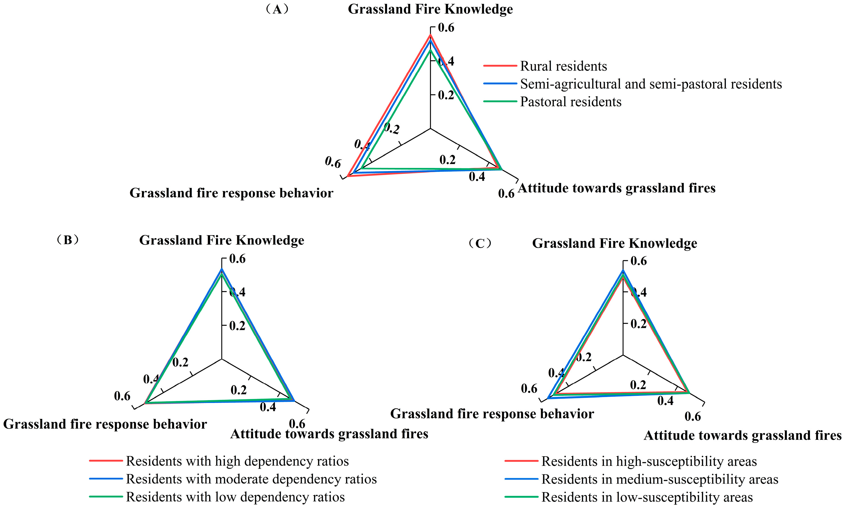
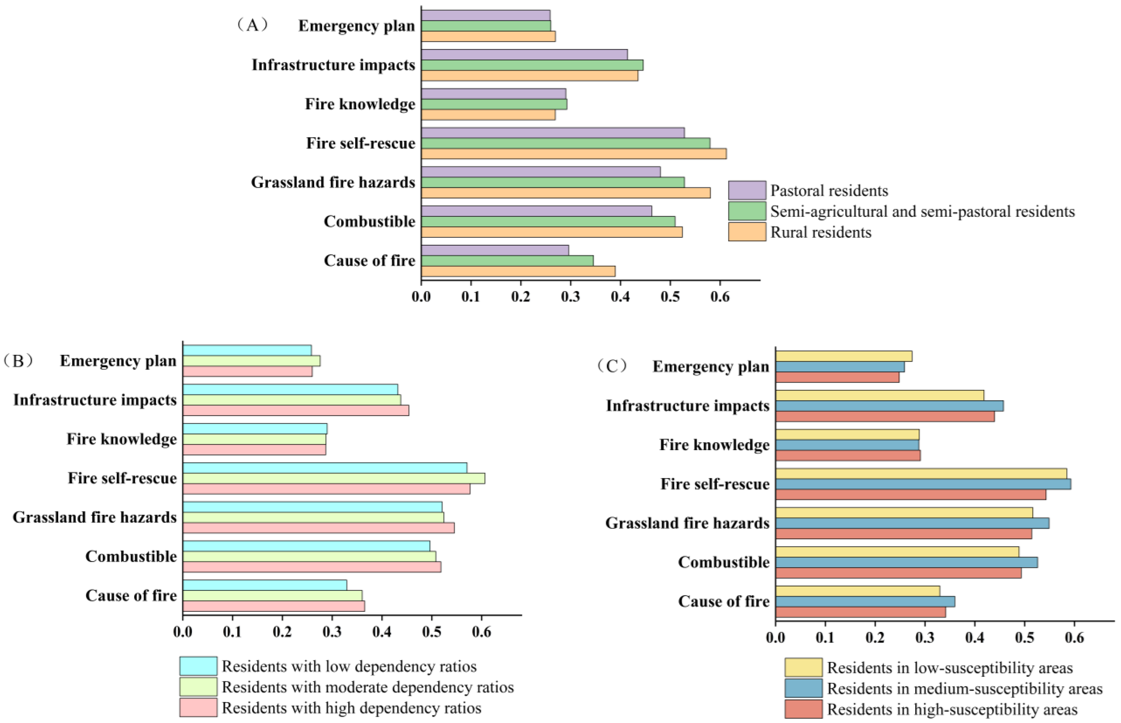
The Kruskal–Wallis test revealed significant differences in grassland fire knowledge scores across agricultural and pastoral production types (H = 35.69, p < 0.001, ε2 = 0.0284). Residents in agricultural areas scored highest (0.553), followed by semi-agricultural/semi-pastoral areas (0.521), with pastoral areas scoring lowest (0.463) (Figure 2). These differences likely reflect variations in risk communication effectiveness and diversity of information channels. In agricultural areas, 39.53% of residents primarily access information via television, WeChat, radio, and government lectures. In pastoral areas, 49.10% rely on interpersonal communication with family and friends, and vast, sparsely populated terrain hinders information transmission. Agricultural areas also possess more developed fire safety systems, stronger disaster prevention and self-rescue awareness, and a higher proportion of residents with secondary education or above (73.25%) than pastoral areas (54.49%). Regarding willingness to acquire additional fire prevention knowledge, semi-agricultural/semi-pastoral areas report the highest proportion (83.86%), followed by agricultural (81.40%) and pastoral areas (78.44%). Although not statistically significant, the first two categories benefit from stronger comprehension capacity and broader access to information channels (Figure 3).
Based on the dependency ratio (H = 11.47, p = 0.00323, ε2 = 0.0080), residents with high dependency ratios (0.533) scored significantly higher than those with low ratios (0.505), whereas differences between medium (0.535) and high ratios were not significant (Figure 2). Residents with medium dependency ratios emphasize emergency response and prevention (Figure 3). Survey data indicate that 52.98% of medium ratio households have annual incomes below CNY 30,000, and they scored highest on the “fire self-rescue” item. These households bear moderate family responsibilities, express strong concern for the safety of family members and property, and exhibit clear needs for response capabilities during sudden fires. High-dependency households possess more comprehensive knowledge, with 72.89% holding at least a high school diploma and 94.63% accessing multiple information channels (e.g., internet, short videos, lectures). They also have a higher proportion of elderly residents and a strong concern for grassland safety. In contrast, low-dependency households show limited reliance on grasslands, with 60.06% deriving less than 40% of their income from livestock farming, diversified livelihoods, weaker risk sensitivity, and primarily basic prevention knowledge.
Significant differences were also observed across grassland fire-susceptibility zones (F = 9.20, p < 0.001, η2 = 0.0153). Residents in moderately fire-susceptible zones (0.538) scored significantly higher than those in low-susceptibility (0.510) and high-risk zones (0.496), with no significant difference between the latter two (Figure 2). Except for fire-related knowledge, scores in the moderate-susceptibility group were significantly higher than in the other two groups (Figure 3). This pattern may relate to the scale of grassland fires, as residents demonstrate greater concern and vigilance toward such events. Residents in high-susceptibility areas are predominantly pastoralists, 90% of whom have junior high school education or below, limited access to information, and knowledge gaps that delay responses, resulting in lower scores. Conversely, residents in low-susceptibility areas generally lack risk awareness and possess limited fire-related knowledge.
Overall, residents in agricultural and semi-agricultural/semi-pastoral areas perform better in self-rescue measures and hazard dissemination, whereas those with high dependency ratios and in medium-susceptibility areas demonstrate stronger preventive awareness. Prevention and outreach efforts should leverage the exemplary roles of these latter groups while increasing educational and policy investments in pastoral areas and high-susceptibility zones to promote balanced disaster awareness and response capabilities across regions.
(2)
Attitudes toward grassland fire response
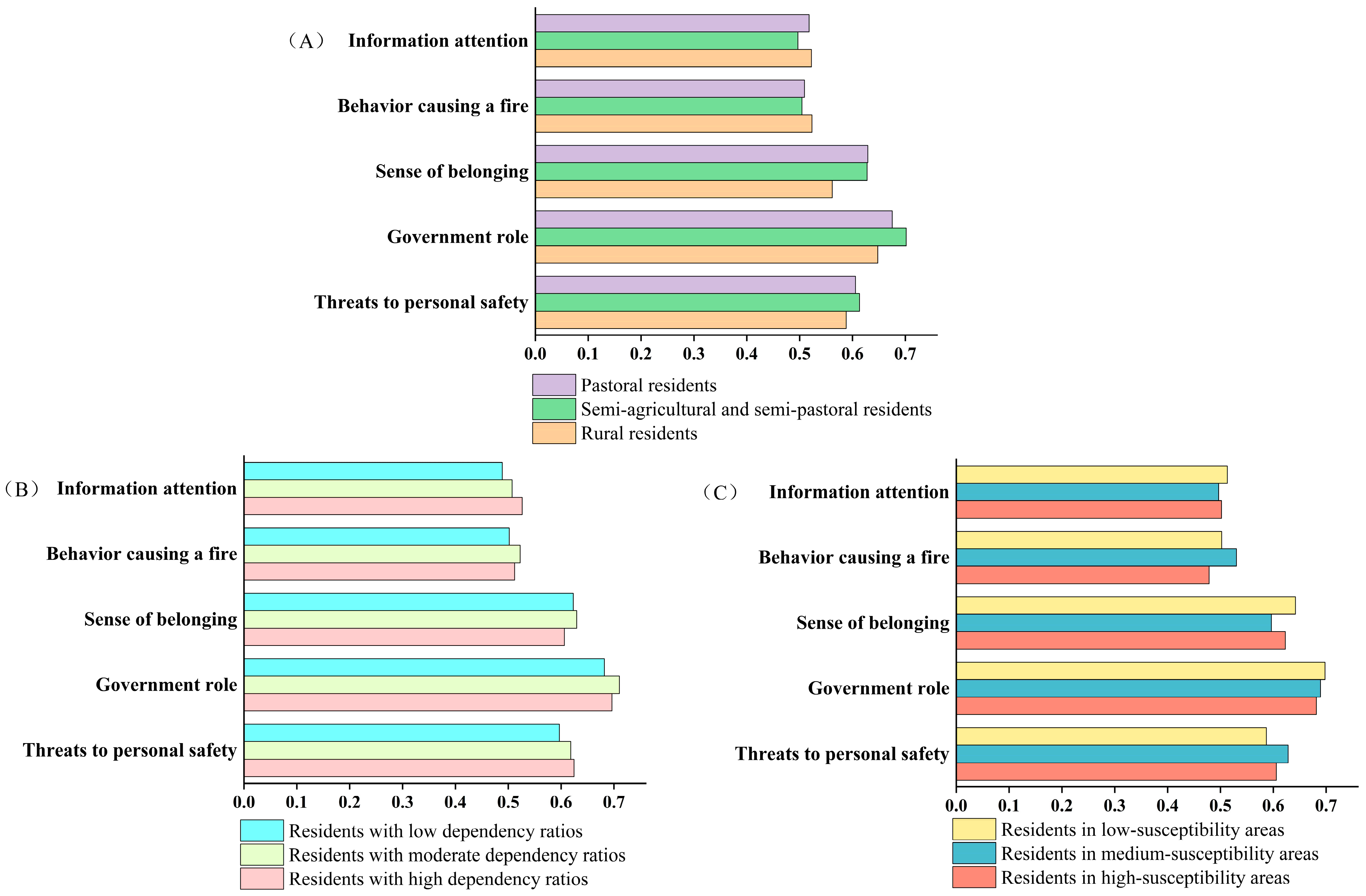
Attitudes toward grassland fire response did not differ significantly across groups. Scores increased slightly with non-agriculturalization (H = 2.92, p = 0.232), ranking as follows: semi-agricultural/semi-pastoral areas (0.486) > pastoral areas (0.484) > agricultural areas (0.461) (Figure 2). Residents in semi-agricultural/semi-pastoral areas exhibited more proactive responses. Agreement with government-led prevention and control measures was high in both pastoral (75.45%) and semi-agricultural/semi-pastoral areas (76.91%), exceeding that in agricultural areas (69.77%) (Figure 4). For the statement “Families should also play an important role in disaster prevention and mitigation,” agreement was highest in pastoral areas (74.25%), followed by semi-agricultural/semi-pastoral areas (68.43%) and agricultural areas (54.65%), indicating greater emphasis on collective and family participation in the former two groups. Agricultural area residents, primarily engaged in farming, focus on economic losses and recognize the risks of straw burning, whereas pastoral area residents, reliant on natural grasslands and constrained by geographic remoteness and limited resources, often believe individuals cannot control fires.
From the perspective of dependency ratio categories (H = 3.51, p = 0.173), residents with medium dependency ratios exhibit the strongest fire response attitudes, followed by those with high and low dependency ratios. This may be attributed to their greater recognition of the respective roles of government and family in grassland fire prevention. Specifically, the government is viewed as responsible for policy support, information dissemination, and post-disaster recovery, while families are regarded as playing key roles in routine fire prevention and the development of self-rescue capabilities. High dependency ratio households tend to be more concerned about the immediate impacts of disasters, particularly regarding the safety of children and elderly members, and they often respond with heightened sensitivity. However, they may harbor uncertainties regarding the effectiveness of government actions or neighborhood-level mutual assistance. Residents with low dependency ratios demonstrate relatively weak attitudes toward disaster prevention, with noticeable deficiencies in both information attention and fire-related behavioral dimensions. This may be attributed to their predominant focus on daily production activities, which leads to a relative neglect of fire risks, ultimately resulting in diminished awareness and passive attitudes toward fire-related issues.
Across grassland fire-susceptibility zones (H = 0.31, p = 0.858), residents in low-susceptibility areas scored highest (0.486) but showed low risk perception, with only 60.05% perceiving fires as a serious threat to personal safety and 52.76% actively seeking relevant knowledge. Information dissemination appears to play a key role in shaping their attitudes. Residents in high-susceptibility areas scored lower (0.473). Although 64.12% acknowledged fire hazards and 73% believed the government should lead prevention and control, traditional grazing concepts framing fires as natural phenomena reduce proactive individual efforts in prevention and control.
(3)
Grassland fire response behavior.
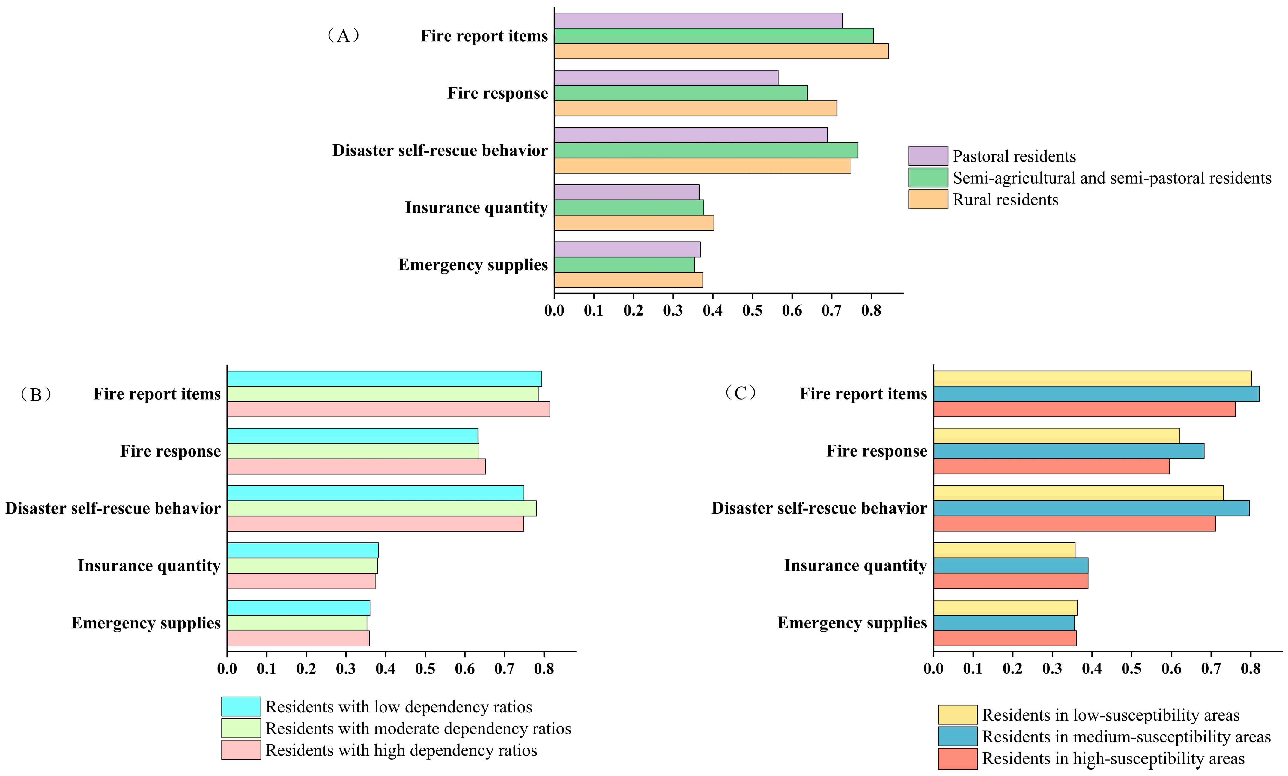
Responses to grassland fires exhibit spatial heterogeneity. By production type, differences were significant (F = 3.35, p = 0.0354, η2 = 0.0056). Scores in agricultural areas (1.014) were significantly higher than in semi-agricultural/semi-pastoral areas (1.007) and pastoral areas (0.948), with semi-agricultural/semi-pastoral areas also scoring significantly higher than pastoral areas. Agricultural areas face considerable agricultural losses from fires and benefit from concentrated populations, rapid information dissemination, and effective prevention campaigns, fostering proactive behaviors such as accurate reporting and appropriate firefighting. In these areas, 31.98% of residents purchase three or more types of insurance, and 80.23% stockpile emergency supplies. In contrast, pastoral areas are characterized by dispersed production, high mobility, and low resource investment, with only 39.52% of residents purchasing any insurance (Figure 5).
By dependency ratio, differences were significant (F = 4.30, p = 0.0138, η2 = 0.0072), with medium (1.032) and high (1.024) ratios scoring significantly higher than low ratios (0.978). Low-dependency households are predominantly led by young adults, possess strong recovery capacity, and tend to underestimate risks. High-dependency households, with a larger proportion of vulnerable groups, show stronger disaster sensitivity and invest more resources (61.13% purchase ≥ 2 types of insurance, 74.68% stockpile emergency supplies).
Across grassland fire-prone zones, differences were significant (F = 3.62, p = 0.0271, η2 = 0.0061), with medium-susceptibility areas (1.024) scoring significantly higher than low-susceptibility (0.995) and high-susceptibility areas (0.968), while the latter two did not differ significantly. In terms of fire-related behaviors (Figure 5), residents in high-susceptibility areas are proactive in purchasing insurance and stockpiling emergency supplies but weaker in fire reporting and response, tending toward preventive measures. Residents in medium-susceptibility areas balance self-rescue, mutual aid, and community strategies, whereas those in low-susceptibility areas emphasize reporting and response after fires occur.

3.2. Factors Influencing Residents’ Perception of Grassland Fire Risk

Using residents’ grassland fire risk perception scores in Qinghai Province as the dependent variable, and residents’ characteristics, climate variables, and risk communication variables as independent variables, a quantile regression model was employed to investigate the key factors influencing risk perception at the 0.25, 0.50, and 0.75 quantiles (Table 3).
At the 0.25, 0.50, and 0.75 quantiles, annual average temperature (X6) exerts a significant positive effect on risk perception (p < 0.01), with coefficients decreasing and stabilizing as the quantile increases. This suggests that rising temperatures increase residents’ risk perception, with a stronger influence on low-perception groups. Annual precipitation (X7) shows a significant negative association with risk perception across all quantiles (p < 0.01), with the effect weakening as the quantile increases and being most pronounced among low-perception groups. This indicates that higher precipitation reduces both the probability of fires and residents’ subjective concern.
Across quantiles, aridity (X8) has a significant negative effect on risk perception (p < 0.01), with the strongest effect among low-perception residents, followed by a slight increase and subsequent decrease. For every unit increase in aridity, risk perception decreases by 3.1% in the low-perception group, compared with 2.6% and 2.7% in the medium- and high-perception groups, respectively. This suggests that increased dryness lowers perception levels, with the most pronounced effect in the low-perception group.
At all three quantiles, the extent of residents’ access to information on grassland fire conditions and safety (X9) has a significant positive association with risk perception (p < 0.01), with a stronger effect in the lower quantile group. This finding suggests that risk communication is particularly effective in enhancing risk perception among low-perception populations.
The findings suggest that risk communication is the primary determinant of grassland fire risk perception. Residents in agricultural areas, who benefit from more efficient access to information and diverse communication channels, demonstrate significantly higher levels of risk perception compared to those in pastoral regions. The climate variables as a secondary influencing factor, as increasing public awareness of climate change has heightened sensitivity to its impact on fire occurrence. However, despite this awareness, residents generally lack sufficient understanding of their own disaster preparedness capabilities and the corresponding response strategies required. Therefore, future efforts in grassland fire risk governance should prioritize enhancing public awareness of individual preparedness and strengthening behavior-oriented risk mitigation capacity. A strategic shift is needed—from an emphasis on recognizing external environmental threats to reinforcing internal coping mechanisms and self-directed disaster response capabilities. This transition represents a critical breakthrough for improving community-based resilience and achieving more adaptive, decentralized risk management systems.

4. Discussion

4.1. Residents’ Perception of Grassland Fire Risk and Response Behavior

Significant differences exist in grassland fire risk perception and response behaviors among residents of Qinghai Province. Agricultural area residents exhibit a “high awareness—low attitude—high behavior” pattern, attributable to the high sensitivity of agricultural production, well-developed fire prevention systems, and effective information dissemination. They acquire more knowledge through government-led publicity and education and possess strong institutional response capabilities [31,68,69]; however, low dependence on grasslands limits their emotional risk awareness. Pastoral residents largely fall into a “low awareness—low behavior” category, lacking scientific knowledge and standardized fire prevention practices. Their highly mobile production systems normalize fire occurrence and rely on experiential coping in high-risk environments. Coupled with limited prevention resources, this results in experience-based judgments supplanting systematic responses, undermining scientific and institutional rigor.
Residents with moderate dependency ratios exhibit high awareness, good alignment between knowledge and behavior, and a high proportion of high-risk perception. High-dependency households, despite better resource conditions, have prevention intentions constrained by livelihood pressures, relying largely on experience-based responses [70]. Low-dependency residents score lowest across all three dimensions, especially in attitude. In this survey, 78.64% of low-dependency residents had never experienced a grassland fire, and 16.41% had experienced only 1–2 incidents. With lighter family responsibilities and weaker direct threats from grassland fires, they demonstrate low behavioral motivation and limited proactive engagement [71].
Residents in medium-susceptibility areas perform best, with comprehensive knowledge, positive attitudes, and proactive behavioral intentions. The uncertainty of medium-susceptibility fire events heightens risk perception, consistent with Slovic’s findings [19]. High-susceptibility area residents score lowest on all three indicators, particularly in attitude and behavior, with prolonged exposure contributing to “risk numbness” [72]. Low-susceptibility residents, despite lower knowledge and attitude scores than those in moderate-susceptibility areas, exhibit stronger behavioral responses, suggesting that occasional fires may trigger short-term preventive actions.
This study assessed risk perception across cognition, attitude, and behavior, but did not sufficiently incorporate institutional and policy contexts. Previous studies indicate that governance fragmentation, inadequate regulatory enforcement, limited interdepartmental collaboration [73], and insufficient public participation constrain wildfire risk management effectiveness. For example, Italy [74] adopts a prevention-oriented institutional design, but implementation remains largely reactive, limiting adaptability and coordination. Future research should integrate governance structures and policy implementation into analytical frameworks to better explain regional differences and inform targeted fire prevention policies [75].
Precision interventions should target specific groups: in agricultural areas, introduce scenario simulations and experiential training grounded in knowledge and institutional frameworks; in pastoral areas, establish mobile training and door-to-door outreach, distribute portable fire prevention tools and monitoring equipment, and disseminate warnings through multiple channels; designate medium-dependency households as demonstration sites, relieve pressure on high-dependency households through subsidies and insurance, and enhance participation of low-dependency households through public welfare programs and community incentives. Enforce mandatory fire prevention regulations and technical inspections in high-susceptibility areas; maintain and enhance proactive measures in medium-susceptibility areas; and reinforce preventive habits in low-susceptibility areas through low-frequency, high-impact publicity campaigns. Across all groups, establish a multi-channel, tiered risk communication system, integrating fire prevention education into school curricula and combining it with local cultural activities to promote intergenerational transmission and long-term consolidation.

4.2. Analysis of Factors Affecting Perception of Grassland Fire Risk in Qinghai Province

The study found that residents’ educational attainment, annual household income, and disaster experience had no significant effects in any quantile models, indicating that individual social attributes exert limited influence on grassland fire risk perception. In this survey, the lowest attitude scores were observed among residents with fire experience (0.490) and those without (0.480), indicating a generally negative stance toward grassland fires. Overall, respondents did not perceive a link between fire occurrence and their own behavior and paid insufficient attention to relevant information, contrary to Meng Wenkao’s [65] findings. In grassland areas, the severity and frequency of fires foster a community-wide consensus on risk perception, transcending individual differences. Previous studies suggest that higher education levels can enhance risk identification and rational judgment [76,77,78], but without personal experience or relevant training, such knowledge is difficult to translate into practical coping abilities. While some studies report stronger perceptions among residents with fire experience [29], Huang Baoyuan [79] found no significant relationship, and others observed increased reliance on government assistance or natural recovery following disasters [80]. Income structure also shows no significant effect: households with diversified income sources have lower grassland dependency and weaker perception, whereas those heavily reliant on livestock may exhibit risk compensation or fatalistic cognition, reducing attention to fire risks. Long-term pastoralists may develop complacency due to a lack of significant past losses, fostering a sense of invulnerability.
Climate variables were constructed using annual average temperature, annual average precipitation, and aridity indices at survey sites. Although grassland fires are strongly associated with natural environmental factors [23,81,82], survey results indicate that residents generally perceive human factors as more influential. The primary anthropogenic ignition sources include smoking outdoors (74.33%), using fire for heating or cooking outdoors (72.40%), and playing with fire or fireworks outdoors (63.42%), followed by burning charcoal (56.96%), burning paper during religious ceremonies (56.21%), and burning fields (40.02%). These activities, embedded in production and living habits, religious practices, and cultural traditions, enjoy a degree of social tolerance in some regions [48]. Among natural factors, lightning strikes (57.38%) and spontaneous combustion (43.96%) are most common. Similar patterns are observed globally in grassland and savanna ecosystems, where anthropogenic ignition sources dominate fire initiation [83]. Residents directly involved in ignition tend to perceive fires as controllable risks, whereas affected residents view them as external threats, reflecting the socio-cultural-political dimensions of fires [81].
Widespread coverage by mass media and social platforms, coupled with government-led unified publicity campaigns [20], can mitigate individual differences, fostering similar risk perceptions across diverse populations. The breadth and timeliness of grassland fire information significantly enhance residents’ risk perception and adaptive capacity [84], consistent with Li Huaqiang’s [85] findings that information sources and channels shape perception and response behaviors. Multiple risk information stimuli can heighten a sense of crisis, whereas timely and effective risk communication can improve cognitive accuracy, enabling residents to adopt appropriate adaptive behaviors and avoid risks [66,86,87].
Grassland fire prevention and suppression efforts should therefore continue to strengthen risk communication, with effective information dissemination as a prerequisite for enhancing perception and response capabilities. Under climate change, attention should be paid to fire dynamics, recognizing residents’ limitations in perception and response. Behavioral guidance and capacity-building initiatives should be implemented to comprehensively improve public understanding of grassland fires.

5. Conclusions

This study adopts the Knowledge–Attitude–Practice (KAP) model as its theoretical framework and constructs an evaluative index system for grassland fire risk perception across three components: knowledge of grassland fires, attitudes toward fire response, and response-related behaviors. In addition, the study empirically examined the risk perceptions of residents in Qinghai Province regarding grassland fires. The main conclusions are as follows:
(1)
The average grassland fire risk perception score among residents in Qinghai Province was 0.509, with response behavior contributing the most, knowledge second, and attitude the least.
(2)
Perception levels were highest in agricultural areas, lowest in pastoral areas; residents with moderate dependency ratios and in moderately fire-susceptible zones performed best, while high-susceptibility zones showed signs of “risk desensitization.”
(3)
Residents of Qinghai Province show distinct variations in their perceptions of grassland fire risks and response behaviors. Agricultural regions should prioritize scenario-based training, pastoral regions’ mobile training, and early warning systems. Measures—such as demonstration projects, subsidies, and welfare incentives—should align with local dependency ratios. High-susceptibility areas require reinforced mandatory prevention, medium- and low-susceptibility areas strengthened proactive strategies. A tiered, multi-channel risk communication system, incorporating fire prevention education into school curricula, is essential for long-term sustainability.
(4)
Strengthening risk communication mechanisms is vital for grassland fire prevention and suppression. Effective information dissemination underpins both residents’ risk perception and collective response systems. With climate change altering fire frequency, spatiotemporal distribution, and intensity, environmental impacts must be closely monitored and risk information promptly updated. Addressing gaps in residents’ knowledge and prevention capacities through targeted guidance can shift them from passive acceptance to active engagement, improving both understanding and response capabilities.

Supplementary Materials

The following supporting information can be downloaded at: https://www.mdpi.com/article/10.3390/fire8090371/s1, Table S1: The weight value calculated by the CRITIC method.

Author Contributions

Writing—original draft preparation, W.X.; conception and writing—review and editing, Q.Z. and F.L.; writing—review and editing, methodology, W.M. and L.L.; investigation, B.N. All authors have read and agreed to the published version of the manuscript.

Funding

This study was supported by the Qinghai Provincial Key R&D and Transformation Program for the Transformation of Scientific and Technological Achievements Special Project, China, under Grant (number 2023-SF-109).

Institutional Review Board Statement

Not applicable.

Informed Consent Statement

Not applicable.

Data Availability Statement

The data presented in this study are available upon request from the corresponding author. The data are not publicly available due to privacy concerns.

Acknowledgments

We are very grateful to the academic editors and reviewers for their valuable suggestions, as well as to the subject students for their contributions in data collection.

Conflicts of Interest

The authors declare no conflicts of interest.

References

  1. Growth, M.F. The Elliptical Shape And Size of Wind-Driven Crown Fires. Fire Manag. 2014, 73, 28–33. [Google Scholar]
  2. Tedim, F.; Leone, V.; Amraoui, M.; Bouillon, C.; Coughlan, M.R.; Delogu, G.M.; Fernandes, P.M.; Ferreira, C.; McCaffrey, S.; McGee, T.K.; et al. Defining Extreme Wildfire Events: Difficulties, Challenges, and Impacts. Fire 2018, 1, 9. [Google Scholar] [CrossRef]
  3. Tedim, F.; Leone, V.; McGee, T.K. Extreme Wildfire Events and Disasters: Root Causes and New Management Strategies; Elsevier: Amsterdam, The Netherlands, 2019. [Google Scholar]
  4. Collins, T.W. What influences hazard mitigation? Household decision making about wildfire risks in Arizona’s White Mountains. Prof. Geogr. 2008, 60, 508–526. [Google Scholar] [CrossRef]
  5. Paveglio, T.B.; Moseley, C.; Carroll, M.S.; Williams, D.R.; Davis, E.J.; Fischer, A.P. Categorizing the social context of the wildland urban interface: Adaptive capacity for wildfire and community “archetypes”. For. Sci. 2015, 61, 298–310. [Google Scholar] [CrossRef]
  6. Eriksen, C.; Gill, N. Bushfire and everyday life: Examining the awareness-action ‘gap’ in changing rural landscapes. Geoforum 2010, 41, 814–825. [Google Scholar] [CrossRef]
  7. Lv, S. The Effect of Risk Perception on the Consumer’s Online Shopping Behaviors. Theory Res. 2010, 52, 45–47. [Google Scholar]
  8. Schroeder, T.C.; Tonsor, G.T.; Pennings, J.M.; Mintert, J. Consumer food safety risk perceptions and attitudes: Impacts on beef consumption across countries. BE J. Econ. Anal. Policy 2007, 7, 1–29. [Google Scholar] [CrossRef]
  9. Xu, D.; Peng, L.; Liu, S.; Wang, X. Influences of risk perception and sense of place on landslide disaster preparedness in southwestern China. Int. J. Disaster Risk Sci. 2018, 9, 167–180. [Google Scholar] [CrossRef]
  10. Lechowska, E. What determines flood risk perception? A review of factors of flood risk perception and relations between its basic elements. Nat. Hazards 2018, 94, 1341–1366. [Google Scholar] [CrossRef]
  11. Siegrist, M.; Árvai, J. Risk perception: Reflections on 40 years of research. Risk Anal. 2020, 40, 2191–2206. [Google Scholar] [CrossRef]
  12. Perić, J.; Cvetković, V.M. Demographic, socio-economic and phycological perspective of risk perception from disasters caused by floods: Case study Belgrade. Int. J. Disaster Risk Manag. 2019, 1, 31–45. [Google Scholar] [CrossRef]
  13. Zhang, Y.; Dong, P.; Fu, P. The Influence of Individual Characteristics on Risk Perception. In Proceedings of the 4th International Conference on Education, Knowledge and Information Management, ICEKIM 2023, Nanjing, China, 26–28 May 2023. [Google Scholar] [CrossRef]
  14. Kirby-Straker, R.; Straker, L. The Effect of Experiencing Disaster Losses on Risk Perceptions and Preparedness Behaviors (Natural Hazards Center Weather Ready Research Report Series, Report 8); Natural Hazards Center, University of Colorado Boulder: Boulder, CO, USA, 2023. [Google Scholar]
  15. da Fonseca, M.N.; da Silva, L.P.; Tedim, F. Corrigendum to “Flood risk communication: Challenges and opportunities in Brazilian cities” [Int. J. Disaster Risk Reduct., Volume 119 (2025) 105292]. Int. J. Disaster Risk Reduct. 2025, 119, 105484. [Google Scholar] [CrossRef]
  16. Oh, J.; Lee, D. Role of trust in government and collaboration in building disaster resilience. Soc. Sci. Q. 2022, 103, 1647–1658. [Google Scholar] [CrossRef]
  17. Kiymis, I.; Kaya, A.A. Development of the Disaster Risk Perception Scale: Evaluation of Its Impact on Disaster Preparedness. Disaster Med. Public Health Prep. 2025, 19, e38. [Google Scholar] [CrossRef] [PubMed]
  18. Cong, Z.; Feng, G.; Chen, Z. Disaster exposure and patterns of disaster preparedness: A multilevel social vulnerability and engagement perspective. J. Environ. Manag. 2023, 339, 117798. [Google Scholar] [CrossRef]
  19. Slovic, P. Perception of risk. Science 1987, 236, 280–285. [Google Scholar] [CrossRef]
  20. Renn, O. Risk Governance: Coping with Uncertainty in a Complex World; Routledge: Oxfordshire, UK, 2017. [Google Scholar]
  21. Chu, W.; Zhang, W.; Wu, X.; Zhang, J.; Liu, S.; Wang, X. Relationship Research Between Public Risk Perception on Extreme Precipitation and Floods and Protective Behavior Motivation—The Case of Aksu Region, Xinjiang. J. Catastrophology 2022, 37, 227–234. [Google Scholar]
  22. Feng, D.; Ning, L. Factors of Public Risk Perception of Geological Hazards in Mining Areas—Take Fushun West Opencast Mining Area as an Example. Sci. Technol. Dev. 2020, 16, 901–908. [Google Scholar]
  23. Tian, L.; Tu, J. Earthquake Risk Perception and Its Influencing Factors in Rural China: A Case Study on Survey Data in Chuxiong of Yunnan Province. Insur. Stud. 2014, 35, 59–69. [Google Scholar]
  24. Mai, N.T.; Truong, D.D. Farming Households’ Perception on Natural Disaster Impacts to Livelihoods and Adaptation Practices: A Case Study of Coastal Provinces in Central Vietnam. Int. J. Sustain. Dev. Plan. 2022, 17, 579–592. [Google Scholar] [CrossRef]
  25. Dada, O.A.; Angnuureng, D.B.; Almar, R.; Morand, P. Linking human perception and scientific coastal flood risk assessment (Anlo Beach Community, Ghana). Ocean Coast. Manag. 2023, 243, 106758. [Google Scholar] [CrossRef]
  26. Sheu, J.-B. Mass evacuation planning for disasters management: A household evacuation route choice behavior analysis. Transp. Res. Part E Logist. Transp. Rev. 2024, 186, 103544. [Google Scholar] [CrossRef]
  27. Oubennaceur, K.; Chokmani, K.; Lessard, F.; Gauthier, Y.; Baltazar, C.; Toussaint, J.-P. Understanding flood risk perception: A Case Study from Canada. Sustainability 2022, 14, 3087. [Google Scholar] [CrossRef]
  28. Cisternas, P.C.; Cifuentes, L.A.; Bronfman, N.C.; Repetto, P.B. The influence of risk awareness and government trust on risk perception and preparedness for natural hazards. Risk Anal. 2024, 44, 333–348. [Google Scholar] [CrossRef]
  29. Wang, C.; Yin, J. Analysis of the Flood Risk Perception and its Influence Factors of Shanghai Residents. J. Catastrophology 2022, 37, 149–154. [Google Scholar]
  30. Zhang, Y.; Tian, M.; Shen, Y.; Qiu, Y.; Li, K. Study on Farmers’ Drought Risk Perception in Yunnan Plateau Mountain: A Case Study of Yuanmou County. Areal Res. Dev. 2021, 40, 156–160. [Google Scholar]
  31. Li, J. Evaluation on public risk perception: A case study on college students. J. Nat. Disasters 2005, 14, 153–156. [Google Scholar]
  32. Khan, A.A.; Rana, I.A.; Nawaz, A. Gender-based approach for assessing risk perception in a multi-hazard environment: A study of high schools of Gilgit, Pakistan. Int. J. Disaster Risk Reduct. 2020, 44, 101427. [Google Scholar] [CrossRef]
  33. Yildiz, A.; Teeuw, R.; Dickinson, J.; Roberts, J. Children’s earthquake preparedness and risk perception: A comparative study of two cities in Turkey, using a modified PRISM approach. Int. J. Disaster Risk Reduct. 2020, 49, 101666. [Google Scholar] [CrossRef]
  34. Bodas, M.; Peleg, K.; Stolero, N.; Adini, B. Risk perception of natural and human-made disasters—Cross sectional study in eight countries in Europe and beyond. Front. Public Health 2022, 10, 825985. [Google Scholar] [CrossRef]
  35. Ng, S.L. Effects of risk perception on disaster preparedness toward typhoons: An application of the extended theory of planned behavior. Int. J. Disaster Risk Sci. 2022, 13, 100–113. [Google Scholar] [CrossRef]
  36. Su, F.; He, C.; Huang, J.; Guo, Z. Current Situation and Trend of Hazard Risk Perception. J. Catastrophology 2016, 31, 146–151. [Google Scholar]
  37. Zhou, X.; Wang, Y.; Zheng, C.; Li, X.; Dong, Z. Study on Flood Risk Awareness and Influencing Factors of Greenhouse Growers: A Case Study in Shandong Province. J. Catastrophology 2021, 36, 215–220. [Google Scholar]
  38. Rana, I.A.; Jamshed, A.; Younas, Z.I.; Bhatti, S.S. Characterizing flood risk perception in urban communities of Pakistan. Int. J. Disaster Risk Reduct. 2020, 46, 101624. [Google Scholar] [CrossRef]
  39. Wang, Z.; Zhang, F.; Liu, S.; Xu, D. Consistency between the subjective and objective flood risk and willingness to purchase natural disaster insurance among farmers: Evidence from rural areas in Southwest China. Environ. Impact Assess. Rev. 2023, 102, 107201. [Google Scholar] [CrossRef]
  40. Huang, H.; Wang, R.; Xiao, Y.; Li, Y.; Zhang, Q.-F.; Xiang, X. Determinants of People’s Secondary Hazards Risk Perception: A Case Study in Wenchuan Earthquake Disaster Areas of China. Front. Earth Sci. 2022, 10, 865143. [Google Scholar] [CrossRef]
  41. Zhou, Q.; Liu, D. Evaluation of flood risk perception of Chinese residents based on KAP model. Yangtze River 2019, 50, 28–34+97. [Google Scholar]
  42. Cui, F.; Liu, Y.; Chang, Y.; Duan, J.; Li, J. An overview of tourism risk perception. Nat. Hazards 2016, 82, 643–658. [Google Scholar] [CrossRef]
  43. Hungerford, H.R.; Volk, T.L. Changing learner behavior through environmental education. J. Environ. Educ. 1990, 21, 8–21. [Google Scholar] [CrossRef]
  44. Gu, X.; Li, X.; Xu, D.; Fan, S.; Zhou, X.; Zhu, Q. Responses of urban residents to rural multifunctional transition in the peri-urban areas: Analysis based on the “Knowledge-Attitude-Behavior”(KAP) Model. Geogr. Res. 2023, 42, 1598–1612. [Google Scholar]
  45. Baranowski, T.; Cullen, K.W.; Nicklas, T.; Thompson, D.; Baranowski, J. Are current health behavioral change models helpful in guiding prevention of weight gain efforts? Obes. Res. 2003, 11, 23S–43S. [Google Scholar] [CrossRef]
  46. Hou, S.-I. Health education: Theoretical concepts, effective strategies and core competencies. Health Promot. Pract. 2014, 15, 619–621. [Google Scholar] [CrossRef]
  47. Xu, M.; Zhang, Z. Farmers’ knowledge, attitude, and practice of rural industrial land changes and their influencing factors: Evidences from the Beijing-Tianjin-Hebei region, China. J. Rural Stud. 2021, 86, 440–451. [Google Scholar]
  48. Xu, W.; Zhou, Q.; Ma, W.; Huang, Y. Analysis of the Spatial Distribution Pattern of Grassland Fire Susceptibility and Influencing Factors in Qinghai Province. Appl. Sci. 2025, 15, 3386. [Google Scholar] [CrossRef]
  49. Huang, Y.; Xia, X.; Zhou, Q.; Pan, Y.; Chen, Y.; Li, H. Spatial and Temporal Patterns and Causes of Grassland Fires in Qinghai Province. Prog. Geogr. 2023, 42, 1973–1983. [Google Scholar] [CrossRef]
  50. Zhou, X.; Xu, W.; Yuan, Y.; Ma, Y.; Qian, X.; Ge, Y. Overview on Research Methods and Application of Hazard Risk Perception. J. Catastrophology 2012, 27, 114–118. [Google Scholar]
  51. Bubeck, P.; Botzen, W.J.W.; Aerts, J.C. A review of risk perceptions and other factors that influence flood mitigation behavior. Risk Anal. Int. J. 2012, 32, 1481–1495. [Google Scholar] [CrossRef]
  52. Grothmann, T.; Reusswig, F. People at risk of flooding: Why some residents take precautionary action while others do not. Nat. Hazards 2006, 38, 101–120. [Google Scholar] [CrossRef]
  53. Bai, D.; Cao, Y.; Zhang, Y. Temporal and spatial distribution of extreme precipitation in Qinghai Province in recent 60 years. Yangtze River 2022, 53, 59–64. [Google Scholar]
  54. Jiang, L.; Fu, L.; Wang, Y.; Wang, Y. Risk perception of rural inhabitants and their capacity to respond to typhoon. Chin. Rural Health Serv. Adm. 2011, 31, 715–717. [Google Scholar]
  55. Liu, X.; Shang, Z. Risk analysis methods of natural disasters and their applicability. Prog. Geogr. 2014, 33, 1486–1497. [Google Scholar]
  56. Savadori, L.; Savio, S.; Nicotra, E.; Rumiati, R.; Finucane, M.L.; Slovic, P. Expert and public perception of risk from biotechnology. In The Feeling of Risk; Routledge: Oxfordshire, UK, 2013; pp. 245–260. [Google Scholar]
  57. Yang, W.; Luo, J.; Zhou, Z. Emotional State, Interest in the Information and Perception of Earthquake Risk. Insur. Stud. 2014, 35, 61–71. [Google Scholar]
  58. Li, H.; Fan, C.; Jia, J.; Wang, S.; Hao, L. The Public Perception of Risks and the Management of Emergency Measures Taken during Unexpected Calamities. J. Manag. World 2009, 25, 52–60+187–188. [Google Scholar] [CrossRef]
  59. Li, J.; Zhou, Q.; Yan, R. Study on index system for assessment of populace’s ability in calamity perception. J. Nat. Disasters 2002, 11, 129–134. [Google Scholar]
  60. Gaillard, J.-C. Alternative paradigms of volcanic risk perception: The case of Mt. Pinatubo in the Philippines. J. Volcanol. Geotherm. Res. 2008, 172, 315–328. [Google Scholar] [CrossRef]
  61. Cao, X.; Lei, Y.; Gong, Y.; Zhang, S.; Luo, X. Study on health assessment method of shearer based on combination weighting method. Coal Sci. Technol. 2020, 48, 135–141. [Google Scholar]
  62. Zhang, L.; Zhang, X. Weighted clustering method based on improved CRITIC method. Stat. Decis. 2015, 31, 65–68. [Google Scholar]
  63. Wu, X. Comparative analysis of three weighting methods. China Collect. Econ. 2016, 32, 73–74. [Google Scholar]
  64. Bosschaart, A.; Kuiper, W.; van der Schee, J.; Schoonenboom, J. The role of knowledge in students’ flood-risk perception. Nat. Hazards. 2013, 69, 1661–1680. [Google Scholar]
  65. Meng, W. Study on Risk Perception and Influencing Factors of Citrus Growers—A Take Xiangzhou County of Laibin City as an Exampl. Master’s Thesis, Guangxi University, Nanning, China, 2023. [Google Scholar]
  66. Xiao, F.; Zheng, R. Analysis of Current Chinese Research on Cognition and Decision. Adv. Psychol. Sci. 2003, 21, 281–288. [Google Scholar]
  67. Sun, Y.; Zhao, X. Evolution of Livelihood Resilience and Its Influencing Factors of Out-of Poverty Farmers in Longnan Mountainous Area. Geogr. Sci. 2022, 42, 2160–2169. [Google Scholar]
  68. Hasibuan, A.M.; Gregg, D.; Stringer, R. Accounting for diverse risk attitudes in measures of risk perceptions: A case study of climate change risk for small-scale citrus farmers in Indonesia. Land Use Policy 2020, 95, 104252. [Google Scholar] [CrossRef]
  69. Huang, H. Media use, environmental beliefs, self-efficacy, and pro-environmental behavior. J. Bus. Res. 2016, 69, 2206–2212. [Google Scholar] [CrossRef]
  70. Li, Y. Study on Livelihood Risks of Herdsmen and Their Risk-Coping Strategies in Qitai County of Xinjiang. Master’s Thesis, Xinjiang Agricultural University, Urumqi, China, 2020. [Google Scholar]
  71. Altarawneh, L.; Mackee, J.; Gajendran, T. The influence of cognitive and affective risk perceptions on flood preparedness intentions: A dual-process approach. Procedia Eng. 2018, 212, 1203–1210. [Google Scholar] [CrossRef]
  72. Hou, L.; Du, W.; Yin, S.; Yu, S. Grassland fire risk assessment based on herder scale: Taking Khan Obo village, Grassland fire risk assessment based on herder scale: Taking Khan Obo village. Acta Ecol. Sin. 2022, 42, 1059–1070. [Google Scholar]
  73. Kirschner, J.; Clark, J.; Boustras, G. Governing wildfires: Toward a systematic analytical framework. Ecol. Soc. 2023, 28, 6. [Google Scholar] [CrossRef]
  74. Kirschner, J.A.; Ascoli, D.; Moore, P.; Clark, J.; Calvani, S.; Boustras, G. Governance drivers hinder and support a paradigm shift in wildfire risk management in Italy. Reg. Environ. Change 2024, 24, 13. [Google Scholar] [CrossRef]
  75. Bacciu, V.; Salis, M.; Arca, B.; Pellizzaro, G.; Ascoli, D.; Delogu, G.M.; Eftychidis, G.; Chuvieco, E.; Gitas, I.; Viegas, D.X. Shifting to a holistic approach in national wildfire management policies: The Italian case. iForest-Biogeosci. For. 2025, 18, 163. [Google Scholar] [CrossRef]
  76. Bao, Z.; Yan, Q. The Driving Mechanism of Environmental Concern on Environmental Behavior—Based on the General Social Survey Data of Ethnic Minority Areas in Yunnan Province. J. Northwest Norm. Univ. (Soc. Sci.) 2022, 59, 120–136. [Google Scholar]
  77. Cui, L.; Li, C.; Jiang, B. Consumers’ perceived deviation towards the qualitative safety risk of domestic infant milk powder and its influential factors. J. China Agric. Univ. 2022, 27, 265–277. [Google Scholar]
  78. Tang, H.; Xu, B. Empirical attribution of consumers’ willingness of food safety governance: A moderated chain mediation model based on theory of planned behavior. Chin. J. Food Hyg. 2022, 34, 1275–1281. [Google Scholar]
  79. Huang, B. Study on Public Perception of Urban River Flood Risk. Master’s Thesis, Lanzhou University, Lanzhou, China, 2023. [Google Scholar]
  80. Gao, X. Impacting Factors of Landslides and Farmers’ Risk Perception in Hani Rice Terraces Heritage Core Area. Master’s Thesis, Yunnan Normal University, Kunming, China, 2019. [Google Scholar]
  81. Archibald, S.; Lehmann, C.E.; Gómez-Dans, J.L.; Bradstock, R.A. Defining pyromes and global syndromes of fire regimes. Proc. Natl. Acad. Sci. USA 2013, 110, 6442–6447. [Google Scholar] [PubMed]
  82. Andela, N.; Morton, D.C.; Giglio, L.; Chen, Y.; van der Werf, G.R.; Kasibhatla, P.S.; DeFries, R.S.; Collatz, G.; Hantson, S.; Kloster, S. A human-driven decline in global burned area. Science 2017, 356, 1356–1362. [Google Scholar] [CrossRef]
  83. Fusco, E.J.; Abatzoglou, J.T.; Balch, J.K.; Finn, J.T.; Bradley, B.A. Quantifying the human influence on fire ignition across the western USA. Ecol. Appl. 2016, 26, 2390–2401. [Google Scholar] [CrossRef]
  84. Luo, L.; Zhao, X.; Wang, Y.; Zhang, Q.; Xue, B. Farmers’ perception of climate change based on a structural equation model: A case study in the Gannan Plateau. Acta Ecol. Sin. 2017, 37, 3274–3285. [Google Scholar] [CrossRef][Green Version]
  85. Li, H.; Gong, L.; Fan, C. The Formation Mechanism of the Public’s Coping Behavior in Drug Safety Events. J. Public Manag. 2019, 16, 97–107+172–173. [Google Scholar][Green Version]
  86. Adger, W.N.; Vincent, K. Uncertainty in adaptive capacity. Comptes Rendus Geosci. 2005, 337, 399–410. [Google Scholar] [CrossRef]
  87. Kuruppu, N. Adapting water resources to climate change in Kiribati: The importance of cultural values and meanings. Environ. Sci. Policy 2009, 12, 799–809. [Google Scholar] [CrossRef]
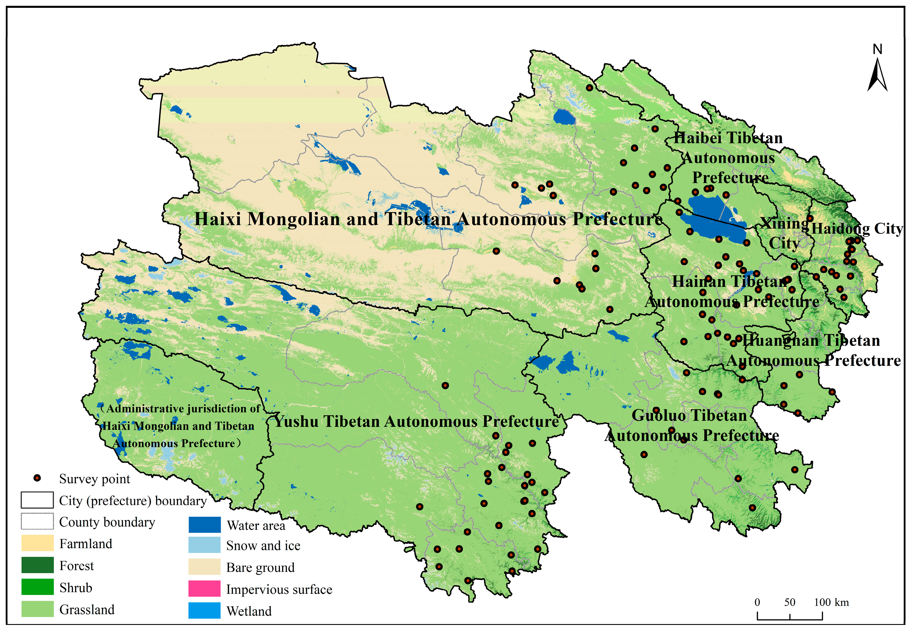
Figure 1. Survey point distribution map.
Fire 08 00371 g001
Figure 2. Three-dimensional distribution of grassland fire risk perception among different types of residents. (A) Different types of agricultural and livestock production; (B) Different dependency ratio; (C) Different grassland fire-susceptibility areas.
Fire 08 00371 g002
Figure 3. Three-dimensional distribution of grassland fire risk perception across resident typologies (AC) refer to production type, dependency ratio, and fire susceptibility zone classifications, respectively).
Fire 08 00371 g003
Figure 4. Attitude scores toward grasslands among different types of residents (AC) refer to production type, dependency ratio, and fire susceptibility zone classifications, respectively).
Fire 08 00371 g004
Figure 5. Scores for grassland behavior of different types of residents (AC) refer to production type, dependency ratio, and fire susceptibility zone classifications, respectively).
Fire 08 00371 g005
Table 1. Grassland fire risk perception evaluation system and weighting.
Primary IndicatorSecondary IndicatorsTertiary Indicators
IndicatorWeighting ω IndicatorSurvey QuestionQuestion TypeWeighting W
Residents’ perception of grassland fire riskKnowledge related to grassland fires (K)0.412Cause of fire(K1) Which of the following do you think are the causes of grassland fires?MRQ0.142
Combustible material(K2) Which of the following are combustible materials found on grasslands?MRQ0.148
Fire hazard(K3) What are the main hazards of grassland fires?MRQ0.147
Fire Self-Rescue(K4) Do you think the statement about self-rescue in grassland fires is correct?SRQ0.147
Fire Safety Knowledge(K5) How much do you know about grassland fires (firefighting measures)?SRQ0.137
Infrastructure impact(K6) Do you know how much grassland fires affect infrastructure?SRQ0.143
Emergency plan(K7) How familiar are you with emergency response plans?SRQ0.137
Attitude toward responding to grassland fires (A)0.292Threat to personal safety(A1) How much of a threat do you think grassland fires pose to the safety of your family?SRQ0.200
Government role(A2) Should government departments play a greater role in preventing and mitigating grassland fires?SRQ0.204
Sense of belonging(A3) Can families play a greater role in preventing and mitigating grassland fires?SRQ0.202
Behavior causing a fire(A4) Do you think your actions could cause a grassland fire?SRQ0.192
Information attention(A5) How concerned are you about information related to grassland fires?SRQ0.202
Grassland fire response behavior (P)0.295Emergency supplies(P1) Does your family consciously stockpile emergency supplies?SRQ0.199
Insurance quantity(P2) How much insurance do you purchase?MRQ0.191
Disaster self-rescue behavior(P3) If a grassland fire occurs, would you engage in self-rescue and mutual aid among the public?SRQ0.202
Fire response(P4) If you were to experience a grassland fire, what would you do?MRQ0.203
Fire Report Items(P5) When you discover a grassland fire, what should you report?MRQ0.205
SRQ = Single Response Question; MRQ = Multiple Response Question.
Table 2. Meaning and description of influencing factors.
DimensionIndependent VariableVariable Interpretation and AssignmentMeanStandard Deviation
Resident characteristicsLevel of education (X1)Illiterate = 1; Elementary school = 2; Junior high school = 3; High school or vocational school = 4; College or university and above = 52.8240.865
Grassland area (X2)Grassland area /acre393.3192313.510
Annual household income (X3)less than 10,000 = 1; 10,000–30,000 = 2; 30,000–100,000 = 3; 100,000–500,000 = 4; and 500,000 or more = 5.2.2401.024
Percentage of household income attributable to livestock farming (X4)Less than 20% = 1; 20–40% = 2; 40–60% = 3; 60–80% = 4; More than 80% = 51.9901.260
Number of grassland fires experienced (X5)No experience = 1; 1–2 times = 2; 3–4 times = 3; 5–6 times = 4; 7 times or more = 51.2290.512
Climate variablesAnnual average temperature (X6)Local average annual temperature/°C−0.6514.141
Annual precipitation (X7)Local annual average precipitation/mm421.421103.745
Dryness (X8)ArcGIS 10.8 extraction of dryness of survey points2.3141.094
Risk communicationReceived information on grassland fire conditions and safety measures (X9)Never received = 1; Rarely received = 2; Sometimes received = 3; Often received = 4; Always received = 53.2881.343
Table 3. Quantile regression results.
Title 1Explanatory Variableγ = 0.25γ = 0.50γ = 0.75
CoefficienttCoefficienttCoefficientt
S1X1−0.003−0.5650.0030.570.0061.114
X2−0.000001408−0.675−0.0000001542−0.081−0.000001785−0.911
X3−0.002−0.4990.0041.2550.0031.137
X4−0.002−0.4370.0010.1450.0000.067
X5−0.005−0.529−0.006−0.723−0.007−0.771
S2X60.006 ***4.3790.005 ***3.8280.005 ***3.601
X70.000 ***−4.7960.000 ***−3.4740.000 ***−3.289
X8−0.031 ***−3.579−0.026 ***−3.281−0.027 ***−3.289
S3X90.028 ***7.7090.024 ***7.4240.023 ***6.79
Sample size118811881188
Pseudo-R20.0780.0530.047
S1 = Resident characteristics; S2 = Climate variables; S3 = Risk communication. X1 = Educational attainment; X2 = Pasture area; X3 = Annual household income; X4 = Proportion of household income derived from animal husbandry; X5 = Number of grassland fire experiences; X6 = Average annual temperature; X7 = Average annual precipitation; X8 = Aridity; X9 = Receipt of information on grassland fire conditions and safety measures. *** indicates significance at the 0.01 level.
Disclaimer/Publisher’s Note: The statements, opinions and data contained in all publications are solely those of the individual author(s) and contributor(s) and not of MDPI and/or the editor(s). MDPI and/or the editor(s) disclaim responsibility for any injury to people or property resulting from any ideas, methods, instructions or products referred to in the content.