Burned Area Mapping and Fire Severity Assessment of Forest–Grassland Ecosystems Using Time-Series Landsat Imagery (1985–2023): A Case Study of Daxing’anling Region, China
Abstract
1. Introduction
2. Materials and Methods
2.1. Study Area
2.2. Datasets
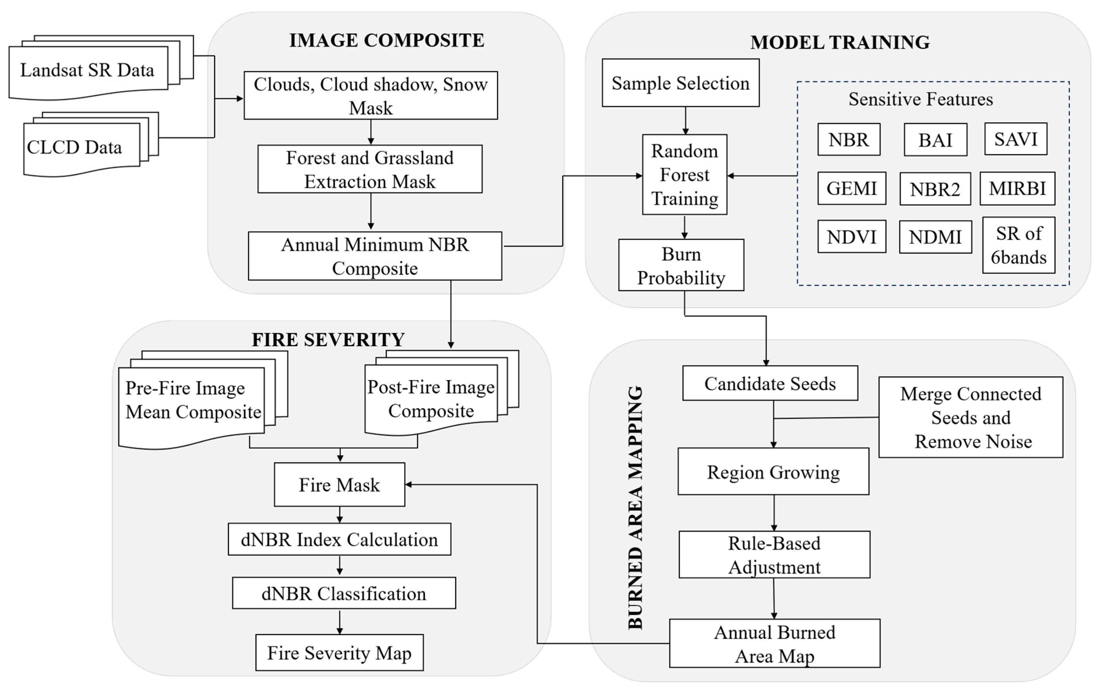
2.3. Technical Approach
2.4. Annual Composite of Time-Series Landsat Imagery
2.5. Sample Design
2.6. Feature Variable Selection
2.7. Random Forest Modeling
2.8. Region Growing
2.9. Correction of Burned Area
2.10. Validation of Burned Area Mapping
2.11. Fire Severity
2.12. Validation of Fire Severity Classification
3. Results
3.1. Product Description
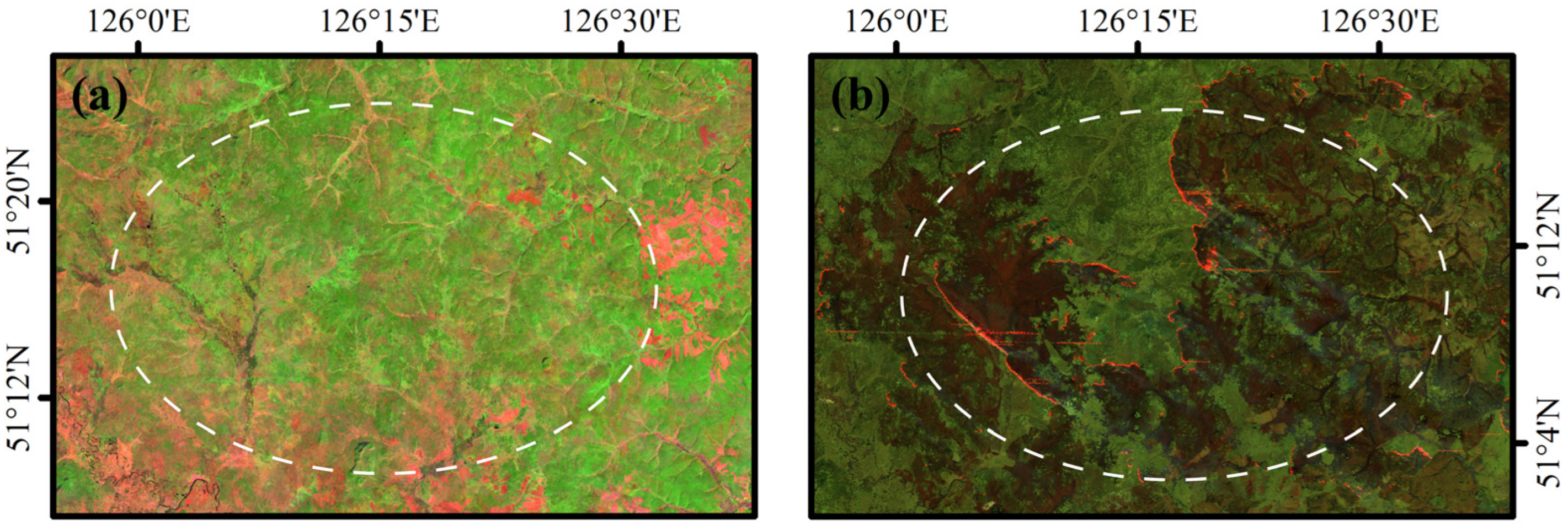
3.1.1. Mapping of Forest Burned Areas
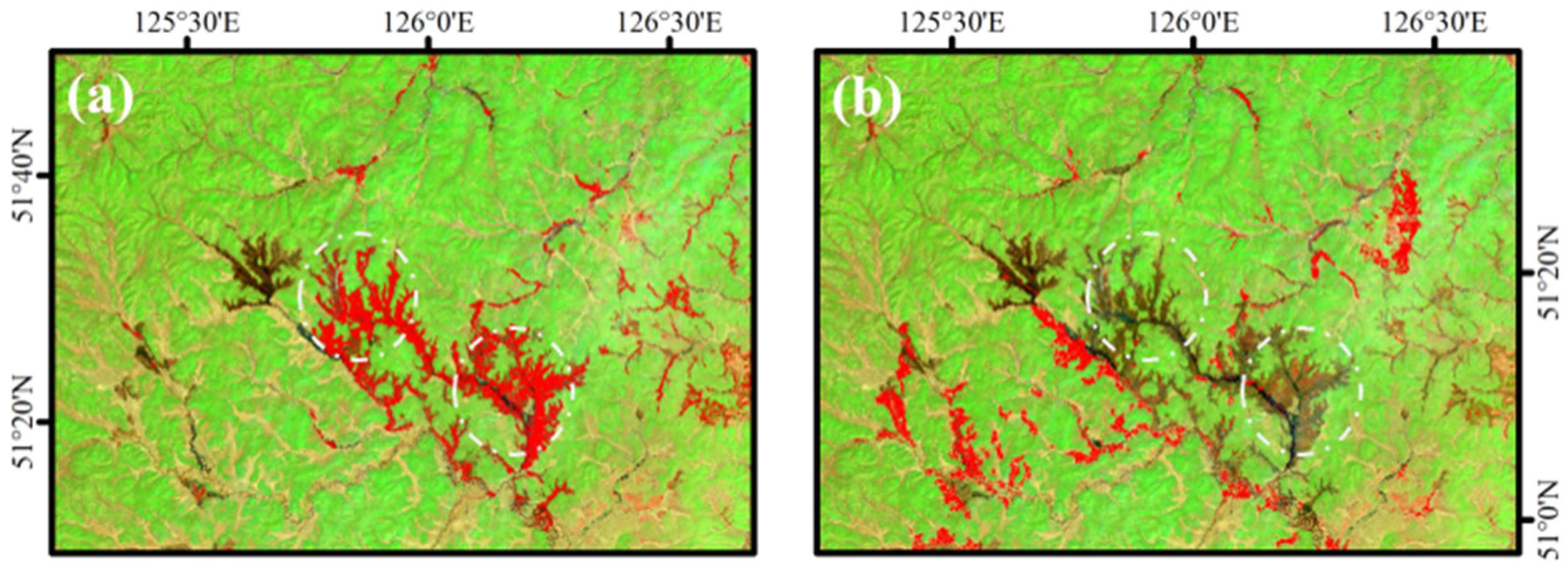
3.1.2. Correction of Grassland Burned Area
3.2. Validation
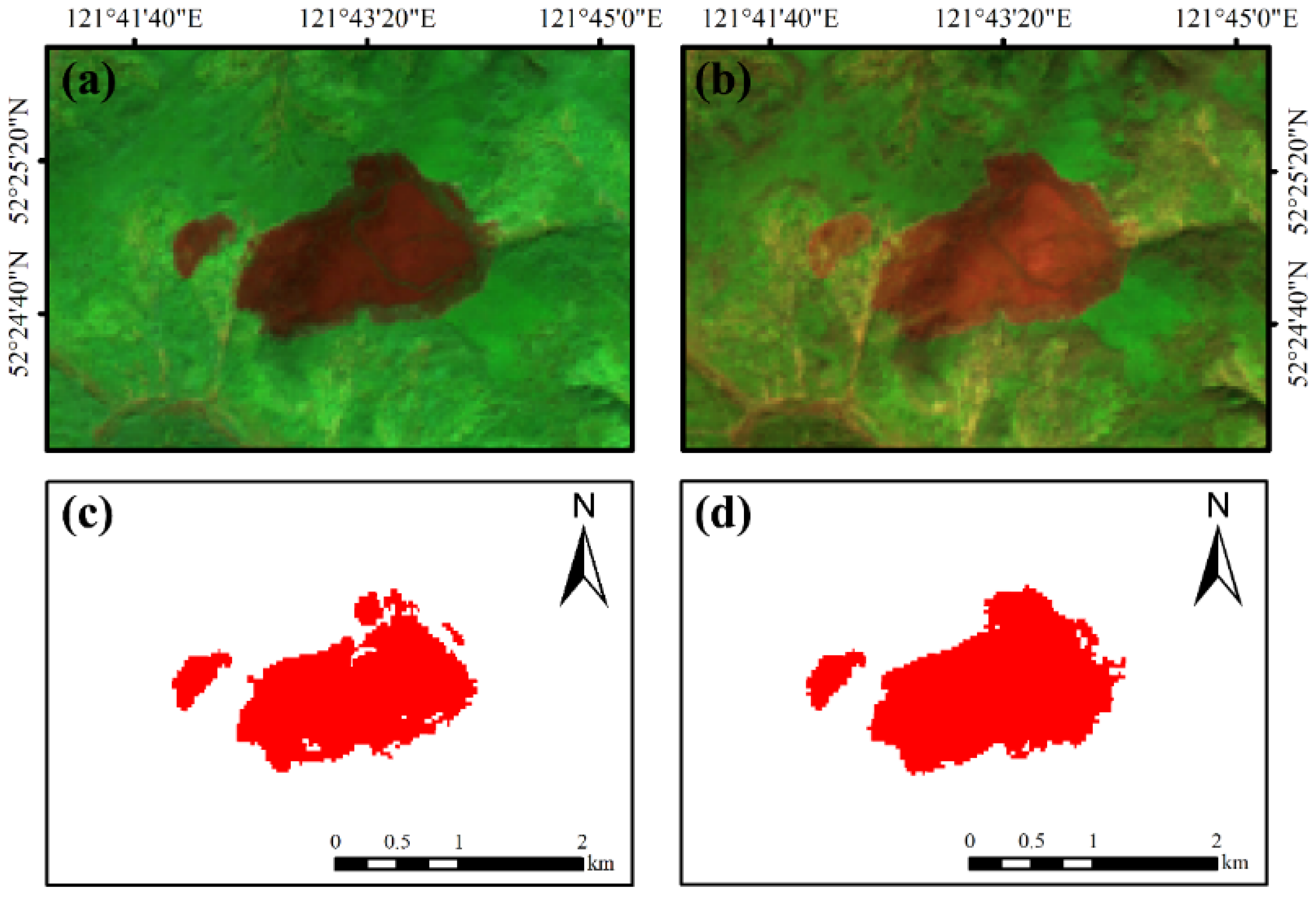
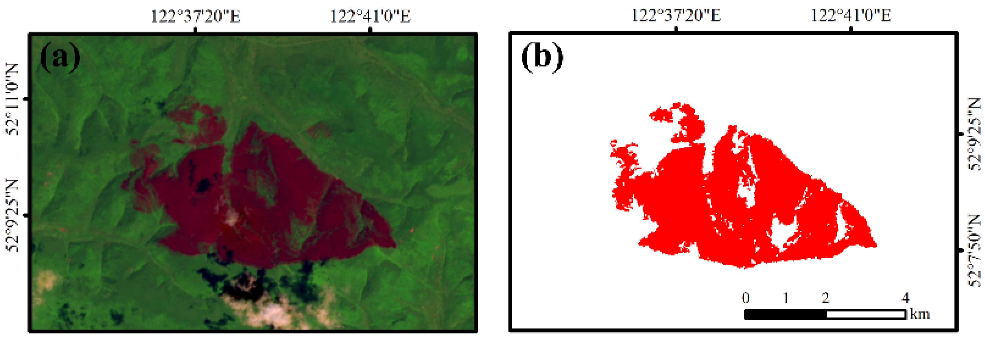
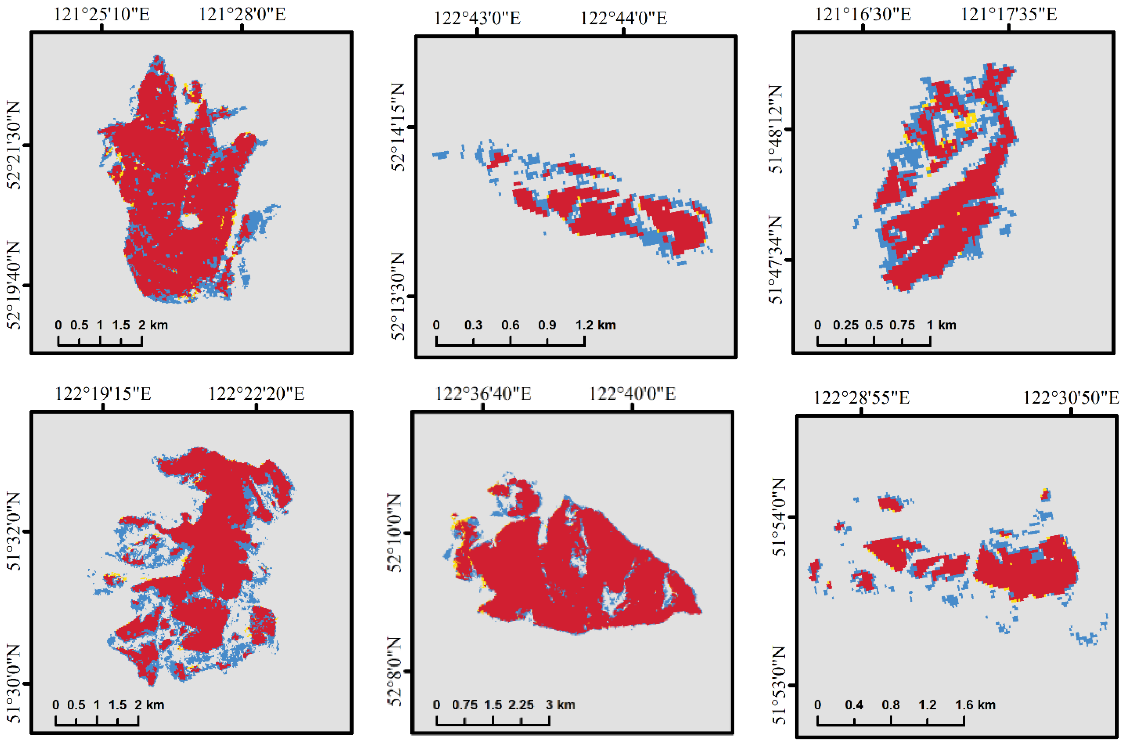
3.2.1. Validation of Burned Area Mapping
3.2.2. Validation of Fire Severity Mapping
3.3. Long-Term Temporal Trends of Burned Area
3.4. Comparison of Different Burned Area Products
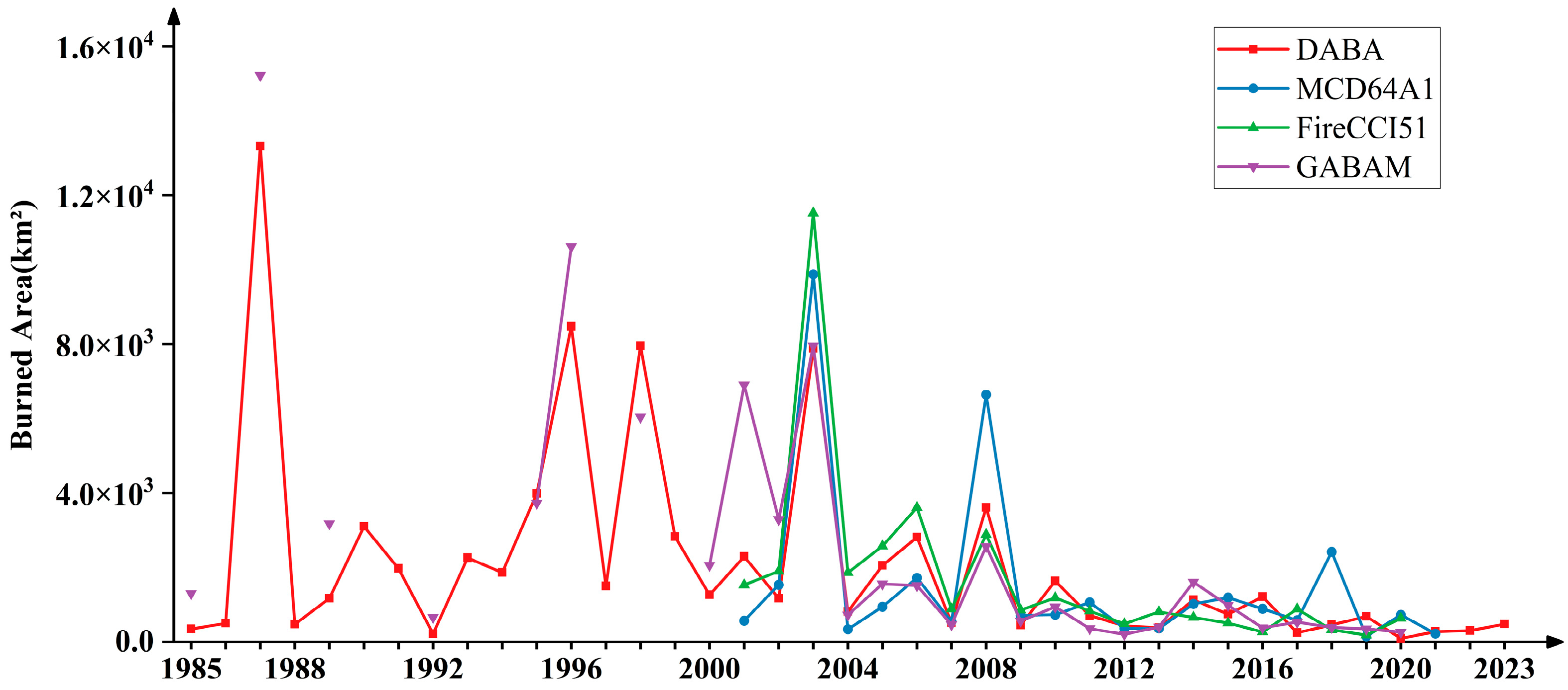
3.4.1. Comparison of Temporal Trends in Existing Burned Area Products
3.4.2. Spatial Comparison of Burned Area
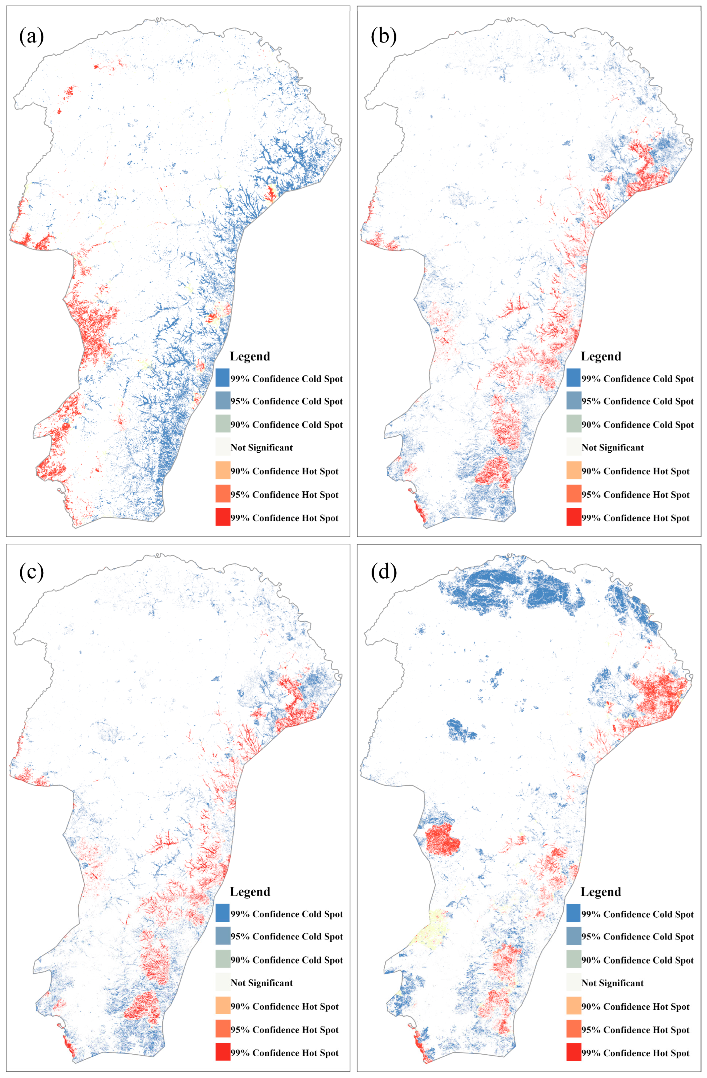
3.5. Spatial and Temporal Patterns of Fire Severity
4. Discussion
5. Conclusions
Author Contributions
Funding
Acknowledgments
Conflicts of Interest
References
- Roberts, G.; Wooster, M.J.; Strydom, T. Assessment and validation of Meteosat SEVIRI fire radiative power (FRP) retrievals over Kruger National Park. Int. J. Appl. Earth Obs. Geoinf. 2025, 136, 104375. [Google Scholar] [CrossRef]
- Vallet, L.; Abdallah, C.; Lauvaux, T.; Joly, L.; Ramonet, M.; Ciais, P.; Lopez, M.; Xueref-Remy, I.; Mouillot, F. Soil smoldering in temperate forests: A neglected contributor to fire carbon emissions revealed by atmospheric mixing ratios. Biogeosciences 2025, 22, 213–242. [Google Scholar] [CrossRef]
- Humber, M.L.; Boschetti, L.; Giglio, L. Assessing the Shape Accuracy of Coarse Resolution Burned Area Identifications. IEEE Trans. Geosci. Remote Sens. 2020, 58, 1516–1526. [Google Scholar] [CrossRef]
- Goodwin, N.R.; Collett, L.J. Development of an automated method for mapping fire history captured in Landsat TM and ETM+ time series across Queensland, Australia. Remote Sens. Environ. 2014, 148, 206–221. [Google Scholar] [CrossRef]
- Kurbanov, E.; Vorobev, O.; Lezhnin, S.; Sha, J.; Wang, J.; Li, X.; Cole, J.; Dergunov, D.; Wang, Y. Remote Sensing of Forest Burnt Area, Burn Severity, and Post-Fire Recovery: A Review. Remote Sens. 2022, 14, 4714. [Google Scholar] [CrossRef]
- Hawbaker, T.J.; Vanderhoof, M.K.; Beal, Y.-J.; Takacs, J.D.; Schmidt, G.L.; Falgout, J.T.; Williams, B.; Fairaux, N.M.; Caldwell, M.K.; Picotte, J.J.; et al. Mapping burned areas using dense time-series of Landsat data. Remote Sens. Environ. 2017, 198, 504–522. [Google Scholar] [CrossRef]
- Lentile, L.; Holden, Z.; Smith, A.; Falkowski, M.; Hudak, A.T.; Morgan, P.; Lewis, S.; Gessler, P.; Benson, N. Remote sensing techniques to assess active fire characteristics and post-fire effects. Int. J. Wildland Fire 2006, 15, 319–345. [Google Scholar] [CrossRef]
- Chuvieco, E.; Lizundia-Loiola, J.; Pettinari, M.L.; Ramo, R.; Padilla, M.; Tansey, K.; Mouillot, F.; Laurent, P.; Storm, T.; Heil, A.; et al. Generation and analysis of a new global burned area product based on MODIS 250 m reflectance bands and thermal anomalies. Earth Syst. Sci. Data 2018, 10, 2015–2031. [Google Scholar] [CrossRef]
- Key, C.H.; Benson, N.C. The Normalized Burn Ratio (NBR): A Landsat TM Radiometric Measure of Burn Severity; US Geological Survey Northern Rocky Mountain Science Center: Bozeman, MT, USA, 2003.
- Chuvieco, E.; Martín, M.P. Cartografía de grandes incendios forestales en la Península Ibérica a partir de imágenes NOAA-AVHRR. Ser. Geogr. 1998, 7, 109–128. Available online: http://hdl.handle.net/10261/6426 (accessed on 17 August 2025).
- Trigg, S.; Flasse, S. An evaluation of different bi-spectral spaces for discriminating burned shrub-savannah. Int. J. Remote Sens. 2001, 22, 2641–2647. [Google Scholar] [CrossRef]
- Smiraglia, D.; Filipponi, F.; Mandrone, S.; Tornato, A.; Taramelli, A. Agreement Index for Burned Area Mapping: Integration of Multiple Spectral Indices Using Sentinel-2 Satellite Images. Remote Sens. 2020, 12, 1862. [Google Scholar] [CrossRef]
- Alcaras, E.; Costantino, D.; Guastaferro, F.; Parente, C.; Pepe, M. Normalized Burn Ratio Plus (NBR+): A New Index for Sentinel-2 Imagery. Remote Sens. 2022, 14, 1727. [Google Scholar] [CrossRef]
- Pleniou, M.; Koutsias, N. Sensitivity of spectral reflectance values to different burn and vegetation ratios: A multi-scale approach applied in a fire affected area. ISPRS J. Photogramm. Remote Sens. 2013, 79, 199–210. [Google Scholar] [CrossRef]
- Reilly, M.J.; Zuspan, A.; Yang, Z. Characterizing post-fire delayed tree mortality with remote sensing: Sizing up the elephant in the room. Fire Ecol. 2023, 19, 64. [Google Scholar] [CrossRef]
- Fan, J.; Yao, Y.; Tang, Q.; Zhang, X.; Xu, J.; Yu, R.; Liu, L.; Xie, Z.; Ning, J.; Zhang, L. A Hybrid Index for Monitoring Burned Vegetation by Combining Image Texture Features with Vegetation Indices. Remote Sens. 2024, 16, 1539. [Google Scholar] [CrossRef]
- Junpen, A.; Roemmontri, J.; Boonman, A.; Cheewaphongphan, P.; Thao, P.T.; Garivait, S. Spatial and Temporal Distribution of Biomass Open Burning Emissions in the Greater Mekong Subregion. Climate 2020, 8, 90. [Google Scholar] [CrossRef]
- Li, X.; Peng, Q.; Shen, R.; Xu, W.; Qin, Z.; Lin, S.; Ha, S.; Kong, D.; Yuan, W. Long-term reconstructed vegetation index dataset in China from fused MODIS and Landsat data. Sci. Data 2025, 12, 152. [Google Scholar] [CrossRef] [PubMed]
- Koutsias, N.; Pleniou, M. A rule-based semi-automatic method to map burned areas in Mediterranean using Landsat images—Revisited and improved. Int. J. Digit. Earth 2021, 14, 1602–1623. [Google Scholar] [CrossRef]
- Roteta, E.; Bastarrika, A.; Franquesa, M.; Chuvieco, E. Landsat and Sentinel-2 Based Burned Area Mapping Tools in Google Earth Engine. Remote Sens. 2021, 13, 816. [Google Scholar] [CrossRef]
- Liu, J.; Heiskanen, J.; Maeda, E.E.; Pellikka, P.K.E. Burned area detection based on Landsat time series in savannas of southern Burkina Faso. Int. J. Appl. Earth Obs. Geoinf. 2018, 64, 210–220. [Google Scholar] [CrossRef]
- Roteta, E.; Bastarrika, A.; Padilla, M.; Storm, T.; Chuvieco, E. Development of a Sentinel-2 burned area algorithm: Generation of a small fire database for sub-Saharan Africa. Remote Sens. Environ. 2019, 222, 1–17. [Google Scholar] [CrossRef]
- Grégoire, J.M.; Tansey, K.; Silva, J.M.N. The GBA2000 initiative: Developing a global burnt area database from SPOT-VEGETATION imagery. Int. J. Remote Sens. 2003, 24, 1369–1376. [Google Scholar] [CrossRef]
- Simon, M.; Plummer, S.; Fierens, F.; Hoelzemann, J.J.; Arino, O. Burnt area detection at global scale using ATSR-2: The GLOBSCAR products and their qualification. J. Geophys. Res. 2004, 109, 1–16. [Google Scholar] [CrossRef]
- Giglio, L.; Loboda, T.; Roy, D.P.; Quayle, B.; Justice, C.O. An active-fire based burned area mapping algorithm for the MODIS sensor. Remote Sens. Environ. 2009, 113, 408–420. [Google Scholar] [CrossRef]
- Ramo, R.; Roteta, E.; Bistinas, I.; van Wees, D.; Bastarrika, A.; Chuvieco, E.; van der Werf, G.R. African burned area and fire carbon emissions are strongly impacted by small fires undetected by coarse resolution satellite data. Proc. Natl. Acad. Sci. USA 2021, 118, e2011160118. [Google Scholar] [CrossRef]
- Liu, P.; Liu, Y.; Guo, X.; Zhao, W.; Wu, H.; Xu, W. Burned area detection and mapping using time series Sentinel-2 multispectral images. Remote Sens. Environ. 2023, 296, 113753. [Google Scholar] [CrossRef]
- Alencar, A.A.C.; Arruda, V.L.S.; Silva, W.V.; Conciani, D.E.; Costa, D.P.; Crusco, N.; Duverger, S.G.; Ferreira, N.C.; Franca-Rocha, W.; Hasenack, H.; et al. Long-Term Landsat-Based Monthly Burned Area Dataset for the Brazilian Biomes Using Deep Learning. Remote Sens. 2022, 14, 2510. [Google Scholar] [CrossRef]
- Hawbaker, T.J.; Vanderhoof, M.K.; Schmidt, G.L.; Beal, Y.-J.; Picotte, J.J.; Takacs, J.D.; Falgout, J.T.; Dwyer, J.L. The Landsat Burned Area algorithm and products for the conterminous United States. Remote Sens. Environ. 2020, 244, 111801. [Google Scholar] [CrossRef]
- Pereira, A.A.; Libonati, R.; Rodrigues, J.A.; Nogueira, J.; Santos, F.L.M.; Oom, D.; Sanches, W.; Alvarado, S.T.; Pereira, J.M.C. Multi-Sensor, Active Fire-Supervised, One-Class Burned Area Mapping in the Brazilian Savanna. Remote Sens. 2021, 13, 4005. [Google Scholar] [CrossRef]
- Zhang, S.; Bai, M.; Wang, X.; Peng, X.; Chen, A.; Peng, P. Remote sensing technology for rapid extraction of burned areas and ecosystem environmental assessment. PeerJ 2023, 11, e14557. [Google Scholar] [CrossRef] [PubMed]
- Guo, Q.; Su, Y.; Hu, T. Chapter 12—Forest Dynamics Monitoring. In LiDAR Principles, Processing and Applications in Forest Ecology; Guo, Q., Su, Y., Hu, T., Eds.; Academic Press: San Diego, CA, USA, 2023; pp. 379–406. [Google Scholar]
- Davis, K.T.; Robles, M.D.; Kemp, K.B.; Higuera, P.E.; Chapman, T.; Metlen, K.L.; Peeler, J.L.; Rodman, K.C.; Woolley, T.; Addington, R.N.; et al. Reduced fire severity offers near-term buffer to climate-driven declines in conifer resilience across the western United States. Proc. Natl. Acad. Sci. USA 2023, 120, e2208120120. [Google Scholar] [CrossRef] [PubMed]
- Key, C.H.; Benson, N.C. Landscape Assessment:Sampling and Analysis Methods; USDA Forest Service, Rocky Mountain Research Station: Ogden, UT, USA, 2006.
- García-Llamas, P.; Suárez-Seoane, S.; Fernández-Guisuraga, J.M.; Fernández-García, V.; Fernández-Manso, A.; Quintano, C.; Taboada, A.; Marcos, E.; Calvo, L. Evaluation and comparison of Landsat 8, Sentinel-2 and Deimos-1 remote sensing indices for assessing burn severity in Mediterranean fire-prone ecosystems. Int. J. Appl. Earth Obs. Geoinf. 2019, 80, 137–144. [Google Scholar] [CrossRef]
- Lin, S.; Li, L.; Liu, S.; Yang, S.; Lin, D.; Zhao, X.; Chen, L.; Huang, H. Predicting post-fire forest recovery using the 3-PG model with bi-temporal Landsat imagery in high-severity burned areas of Great Xing’an Mountain. For. Ecol. Manag. 2024, 563, 121991. [Google Scholar] [CrossRef]
- Popović, Z.; Bojović, S.; Marković, M.; Cerdà, A. Tree species flammability based on plant traits: A synthesis. Sci. Total Environ. 2021, 800, 149625. [Google Scholar] [CrossRef]
- Tian, X.; Cui, W.; Shu, L.; Zong, X. Effects of Climate Change on Burn Probability of Forests in Daxing’anling. Forests 2019, 10, 611. [Google Scholar] [CrossRef]
- Wang, J.; Ding, Y.; Gao, Z.; Lyu, H.; Shi, L. Exploring the spatio-temporal variations and forest restoration of burned zones in the Great Xing’an Range based on MODIS time series data. Remote Sens. Nat. Resour. 2024, 36, 142–150. [Google Scholar] [CrossRef]
- Crawford, C.J.; Roy, D.P.; Arab, S.; Barnes, C.; Vermote, E.; Hulley, G.; Gerace, A.; Choate, M.; Engebretson, C.; Micijevic, E.; et al. The 50-year Landsat collection 2 archive. Sci. Remote Sens. 2023, 8, 100103. [Google Scholar] [CrossRef]
- Silva-Cardoza, A.I.; Vega-Nieva, D.J.; Briseño-Reyes, J.; Briones-Herrera, C.I.; López-Serrano, P.M.; Corral-Rivas, J.J.; Parks, S.A.; Holsinger, L.M. Evaluating a New Relative Phenological Correction and the Effect of Sentinel-Based Earth Engine Compositing Approaches to Map Fire Severity and Burned Area. Remote Sens. 2022, 14, 3122. [Google Scholar] [CrossRef]
- Liu, D.; Qu, Y.; Yang, X.; Zhao, Q. TSSA-NBR: A Burned Area Extraction Method Based on Time-Series Spectral Angle with Full Spectral Shape. Remote Sens. 2025, 17, 2283. [Google Scholar] [CrossRef]
- Ban, Q.; Wang, Y.; Zhang, H. Study on spatio-temporal dynamic characteristics of forest fires in Daxing’an Mountains, Inner Mongolia. J. For. Eng. 2024, 9, 116–123. [Google Scholar] [CrossRef]
- Lutes, D.C.; Keane, R.E.; Caratti, J.F.; Key, C.H.; Benson, N.C.; Sutherland, S.; Gangi, L.J. Firemon: Fire Effects Monitoring and Inventory System; Department of Agriculture, Forest Service, Rocky Mountain Research Station: Fort Collins, CO, USA, 2006.
- Stroppiana, D.; Boschetti, M.; Zaffaroni, P.; Brivio, P.A. Analysis and Interpretation of Spectral Indices for Soft Multicriteria Burned-Area Mapping in Mediterranean Regions. IEEE Geosci. Remote Sens. Lett. 2009, 6, 499–503. [Google Scholar] [CrossRef]
- Pinty, B.; Verstraete, M.M. GEMI: A non-linear index to monitor global vegetation from satellites. Vegetatio 1992, 101, 15–20. [Google Scholar] [CrossRef]
- Huete, A.R. A soil-adjusted vegetation index (SAVI). Remote Sens. Environ. 1988, 25, 295–309. [Google Scholar] [CrossRef]
- Wilson, E.H.; Sader, S.A. Detection of forest harvest type using multiple dates of Landsat TM imagery. Remote Sens. Environ. 2002, 80, 385–396. [Google Scholar] [CrossRef]
- Lee, K.; Byeongcheol, K.; Park, S. Evaluating the potential of burn severity mapping and transferability of Copernicus EMS data using Sentinel-2 imagery and machine learning approaches. GISci. Remote Sens. 2023, 60, 2192157. [Google Scholar] [CrossRef]
- Makowski, D. Simple random forest classification algorithms for predicting occurrences and sizes of wildfires. Extremes 2023, 26, 331–338. [Google Scholar] [CrossRef]
- Sali, M.; Piaser, E.; Boschetti, M.; Brivio, P.A.; Sona, G.; Bordogna, G.; Stroppiana, D. A Burned Area Mapping Algorithm for Sentinel-2 Data Based on Approximate Reasoning and Region Growing. Remote Sens. 2021, 13, 2214. [Google Scholar] [CrossRef]
- Su, W.; Zhang, C.; Deng, Y.; Zhai, D.; Zhang, M.; Li, S.; Li, F.; Tang, Z.; Lin, L. Assessment of vegetation recovery dynamics over nearly 40 years in the Jizu Mountain burnt area based on Landsat imagery. Acta Ecol. Sin. 2025, 45, 1362–1378. [Google Scholar] [CrossRef]
- Key, C.; Benson, N. Landscape Assessment: Ground Measure of Severity, the Composite Burn Index and Remote Sensing of Severity, the Normalized Burn Ratio; USDA Forest Service: Washington, DC, USA, 2006; pp. L1–L51.
- Wang, X.; Wang, W.; Chang, Y.; Feng, Y.; Chen, H.; Hu, Y.; Chi, J. Fire severity of burnt area in Huzhong forest region of Great Xing’an Mountains, Northeast China based on normalized burn ratio analysis. Chin. J. Appl. Ecol. 2013, 24, 967–974. Available online: https://www.cjae.net/CN/Y2013/V24/I4/967 (accessed on 17 August 2025).
- Long, T.; Zhang, Z.; He, G.; Jiao, W.; Tang, C.; Wu, B.; Zhang, X.; Wang, G.; Yin, R. 30 m Resolution Global Annual Burned Area Mapping Based on Landsat Images and Google Earth Engine. Remote Sens. 2019, 11, 489. [Google Scholar] [CrossRef]
- Bastarrika, A.; Chuvieco, E.; Martín, M.P. Mapping burned areas from Landsat TM/ETM+ data with a two-phase algorithm: Balancing omission and commission errors. Remote Sens. Environ. 2011, 115, 1003–1012. [Google Scholar] [CrossRef]
- Pereira, A.A.; Pereira, J.M.C.; Libonati, R.; Oom, D.; Setzer, A.W.; Morelli, F.; Machado-Silva, F.; De Carvalho, L.M. Burned Area Mapping in the Brazilian Savanna Using a One-Class Support Vector Machine Trained by Active Fires. Remote Sens. 2017, 9, 1161. [Google Scholar] [CrossRef]
- Shan, T.; Wei, Z.; Jie, C.; Tang, S. A burned area mapping method for the FY-3D MERSI based on the single-temporal L1 data and multi-temporal daily active fire products. Int. J. Remote Sens. 2021, 42, 1292–1310. [Google Scholar] [CrossRef]
- Duan, Q.; Liu, R.; Chen, J.; Wei, X.; Liu, Y.; Zou, X. Burned area detection from a single satellite image using an adaptive thresholds algorithm. Int. J. Digit. Earth 2024, 17, 2376275. [Google Scholar] [CrossRef]
- Zidane, I.; Lhissou, R.; Bouli, A.; Mabrouki, M. An improved algorithm for mapping burnt areas in the Mediterranean forest landscape of Morocco. J. For. Res. 2019, 30, 981–992. [Google Scholar] [CrossRef]
- Kouachi, M.E.; Khairoun, A.; Moghli, A.; Rahmani, S.; Mouillot, F.; Baeza, M.J.; Moutahir, H. Forty-Year Fire History Reconstruction from Landsat Data in Mediterranean Ecosystems of Algeria following International Standards. Remote Sens. 2024, 16, 2500. [Google Scholar] [CrossRef]
- Lee, K.; van Leeuwen, W.J.D.; Gillan, J.K.; Falk, D.A. Examining the Impacts of Pre-Fire Forest Conditions on Burn Severity Using Multiple Remote Sensing Platforms. Remote Sens. 2024, 16, 1803. [Google Scholar] [CrossRef]
- Parks, S.A.; Holsinger, L.M.; Voss, M.A.; Loehman, R.A.; Robinson, N.P. Mean Composite Fire Severity Metrics Computed with Google Earth Engine Offer Improved Accuracy and Expanded Mapping Potential. Remote Sens. 2018, 10, 879. [Google Scholar] [CrossRef]






| Data | Usage | Spatial Resolution | Temporal Coverage |
|---|---|---|---|
| Landsat 5 | BA mapping | 30 m | 1985–2000, 2003–2012 |
| Landsat 7 | BA mapping | 30 m | 2001–2002 |
| Lnadsat 8 | BA mapping | 30 m | 2013–2023 |
| Sentinel-2 | Validation | 10 m | 2015–2023 |
| GABAM | Validation | 30 m | 1985–2021 |
| FireCCI51 | Validation | 250 m | 2001–2020 |
| MCD64A1 | Validation | 500 m | 2001–2023 |
| Satellite | Landsat5 | Landsat7 | Landsat8 | Approximate Wavelength (μm) |
|---|---|---|---|---|
| Sensor | TM | ETM+ | OLI | - |
| Blue | B1 | B1 | SR_B2 | 0.45–0.52 |
| Green | B2 | B2 | SR_B3 | 0.53–0.59 |
| Red | B3 | B3 | SR_B4 | 0.63–0.68 |
| NIR | B4 | B4 | SR_B5 | 0.8–0.89 |
| SWIR1 | B5 | B5 | SR_B6 | 1.55–1.70 |
| SWIR2 | B7 | B7 | SR_B7 | 2.10–2.30 |
| Type | Name | Abbreviation | Reference | Formula |
|---|---|---|---|---|
| Burned Area Index | Normalized Burned Ratio | NBR | Key and Benson [9] | |
| Normalized Burned Ratio2 | NBR2 | Lutes, et al. [44] | ||
| Mid-Infrared Burn Index | MIRBI | Trigg and Flasse [11] | ||
| Burned Area Index | BAI | Chuvieco and Martín [10] | ||
| Vegetation Index | Normalized Difference Vegetation Index | NDVI | Stroppiana, et al. [45] | |
| Global Environmental Monitoring Index | GEMI | Pinty and Verstraete [46] | ||
| Soil-Adjusted Vegetation Index | SAVI | Huete [47] | ||
| Normalized Difference Moisture Index | NDMI | Wilson and Sader [48] |
| Product Prediction | Reference | Total | |
|---|---|---|---|
| Burned | Unburned | ||
| Burned | X11 | X12 | X11 + X12 |
| Unburned | X21 | X22 | X21 + X22 |
| Total | X11 + X21 | X12 + X22 | X11 + X12 + X21 + X22 |
| dNBR | Burn Severity |
|---|---|
| 0.1 to 0.27 | Low-severity burn |
| 0.27 to 0.44 | Moderate-low severity burn |
| 0.44 to 0.66 | Moderate-high severity burn |
| 0.66 to 2 | High-severity burn |
| ID | OA | OE | CE | DC |
|---|---|---|---|---|
| 1 | 94.99% | 13.21% | 0.20% | 92.84% |
| 2 | 94.77% | 12.90% | 1.82% | 92.31% |
| 3 | 80.09% | 46.98% | 2.37% | 68.72% |
| 4 | 95.25% | 10.18% | 1.56% | 93.93% |
| 5 | 97.85% | 10.86% | 2.21% | 93.26% |
| 6 | 94.84% | 13.64% | 4.14% | 90.86% |
| 7 | 98.56% | 18.26% | 2.07% | 89.10% |
| 8 | 91.21% | 42.77% | 9.27% | 70.19% |
| 9 | 89.68% | 14.45% | 4.66% | 90.18% |
| 10 | 88.96% | 29.84% | 1.41% | 81.98% |
| 11 | 90.84% | 11.82% | 10.66% | 88.75% |
| 12 | 87.74% | 35.34% | 3.80% | 77.34% |
| 13 | 99.63% | 4.93% | 20.62% | 86.52% |
| 14 | 98.14% | 46.73% | 25.40% | 62.16% |
| 15 | 90.02% | 42.13% | 0.51% | 73.18% |
| 16 | 96.45% | 29.75% | 2.77% | 81.57% |
| 17 | 99.71% | 48.28% | 0.00% | 68.18% |
| 18 | 92.67% | 26.84% | 2.45% | 83.61% |
| 19 | 97.71% | 29.24% | 6.85% | 80.42% |
| 20 | 98.88% | 38.29% | 2.26% | 75.66% |
| Average | 93.90% | 26.32% | 5.25% | 82.04% |
| ID | Low-Severity Accuracy | Moderate-Severity Accuracy | High-Severity Accuracy | Average |
|---|---|---|---|---|
| 1 | 86.36% | 97.11% | 93.47% | 92.31% |
| 2 | 87.50% | 98.64% | 86.26% | 90.80% |
| 3 | 88.89% | 90.67% | 90.71% | 90.09% |
| 4 | 75.00% | 88.89% | 93.12% | 85.67% |
| 5 | 65.71% | 65.38% | 67.82% | 66.31% |
| 6 | 75.00% | 74.29% | 63.56% | 70.95% |
| 7 | 77.78% | 79.27% | 78.39% | 78.48% |
| 8 | 89.47% | 83.33% | 83.51% | 85.44% |
| 9 | 85.71% | 80.65% | 80.72% | 82.36% |
| 10 | 80.00% | 85.25% | 72.33% | 79.19% |
| Average | 81.14% | 84.35% | 80.99% | 82.16% |
Disclaimer/Publisher’s Note: The statements, opinions and data contained in all publications are solely those of the individual author(s) and contributor(s) and not of MDPI and/or the editor(s). MDPI and/or the editor(s) disclaim responsibility for any injury to people or property resulting from any ideas, methods, instructions or products referred to in the content. |
© 2025 by the authors. Licensee MDPI, Basel, Switzerland. This article is an open access article distributed under the terms and conditions of the Creative Commons Attribution (CC BY) license (https://creativecommons.org/licenses/by/4.0/).
Share and Cite
Chen, L.; Wei, B.; Jia, X.; Liu, M.; Zhao, Y. Burned Area Mapping and Fire Severity Assessment of Forest–Grassland Ecosystems Using Time-Series Landsat Imagery (1985–2023): A Case Study of Daxing’anling Region, China. Fire 2025, 8, 337. https://doi.org/10.3390/fire8090337
Chen L, Wei B, Jia X, Liu M, Zhao Y. Burned Area Mapping and Fire Severity Assessment of Forest–Grassland Ecosystems Using Time-Series Landsat Imagery (1985–2023): A Case Study of Daxing’anling Region, China. Fire. 2025; 8(9):337. https://doi.org/10.3390/fire8090337
Chicago/Turabian StyleChen, Lulu, Baocheng Wei, Xu Jia, Mengna Liu, and Yiming Zhao. 2025. "Burned Area Mapping and Fire Severity Assessment of Forest–Grassland Ecosystems Using Time-Series Landsat Imagery (1985–2023): A Case Study of Daxing’anling Region, China" Fire 8, no. 9: 337. https://doi.org/10.3390/fire8090337
APA StyleChen, L., Wei, B., Jia, X., Liu, M., & Zhao, Y. (2025). Burned Area Mapping and Fire Severity Assessment of Forest–Grassland Ecosystems Using Time-Series Landsat Imagery (1985–2023): A Case Study of Daxing’anling Region, China. Fire, 8(9), 337. https://doi.org/10.3390/fire8090337


