Abstract
Burned area (BA) mapping and fire severity assessment are essential for understanding fire occurrence patterns, formulating post-fire restoration strategies and evaluating vegetation recovery processes. However, existing BA datasets are primarily derived from coarse-resolution satellite imagery and often lack sufficient consideration of fire severity. To address these limitations, this study utilized dense time-series Landsat imagery available on the Google Earth Engine, applying the qualityMosaic method to generate annual composites of minimum normalized burn ratio values. These composites imagery enabled the rapid identification of fire sample points, which were subsequently used to train a random forest classifier for estimating per-pixel burn probability. Pixels with a burned probability greater than 0.9 were selected as the core of the BA, and used as candidate seeds for region growing to further expand the core and extract complete BA. This two-stage extraction method effectively balances omission and commission errors. To avoid the repeated detection of unrecovered BA, this study developed distinct correction rules based on the differing post-fire recovery characteristics of forests and grasslands. The extracted BA were further categorized into four fire severity levels using the delta normalized burn ratio. In addition, we conducted a quantitative validation of the BA mapping accuracy based on Sentinel-2 data between 2015 and 2023. The results indicated that the BA mapping achieved an overall accuracy of 93.90%, with a Dice coefficient of 82.04%, and omission and commission error rates of 26.32% and 5.25%, respectively. The BA dataset generated in this study exhibited good spatiotemporal consistency with existing products, including MCD64A1, FireCCI51, and GABAM. The BA fluctuated significantly between 1985 and 2010, with the highest value recorded in 1987 (13,315 km2). The overall trend of BA showed a decline, with annual burned areas remaining below 2000 km2 after 2010 and reaching a minimum of 92.8 km2 in 2020. There was no significant temporal variation across different fire severity levels. The area of high-severity burns showed a positive correlation with the annual total BA. High-severity fire-prone zones were primarily concentrated in the northeastern, southeastern, and western parts of the study area, predominantly within grasslands and forest–grassland ecotone regions.
1. Introduction
Fire disturbance, as an essential climate variable, has profound impacts on terrestrial ecosystems [1]. In the short term, it directly reduces vegetation productivity, accelerates soil erosion, and releases substantial amounts of greenhouse gases, thereby intensifying the greenhouse effect [2]. In addition, fire events cause widespread economic losses and environmental degradation, posing serious threats to human health and sustainable development [3]. Therefore, long-term and high-quality burned area (BA) mapping plays a crucial role in quantifying fire severity, optimizing fire management strategies, and protecting biodiversity [4,5].
To date, large-scale BA mapping has primarily relied on earth observation remote sensing technologies, which enable the rapid detection of surface thermal anomalies and spectral changes associated with fire events [6]. For example, fires damage vegetation by reducing water content and chlorophyll levels, while increasing the surface exposure of bare soil and charred residues [7]. Post-fire vegetation is typically characterized by decreased reflectance in the near-infrared band (NIR) and increased reflectance in the red and shortwave infrared (SWIR) bands [8]. Based on these principles, researchers have developed a range of spectral indices for rapid BA detection, including the Normalized Burn Ratio (NBR) [9], Burn Area Index (BAI) [10], and Mid-Infrared Burn Index (MIRBI) [11].
Nevertheless, the applicability of a single spectral index remains limited in complex surface environments [12]. Some studies have noted that BA can be easily confused with water bodies, clouds, shadows, and other similar features, as well as areas where vegetation mortality is delayed following fire events [13,14,15]. Combining multiple spectral indices with auxiliary data (e.g., topography and climate) has become a key approach to improving the accuracy of burned area mapping [16]. Junpen et al. [17] and Li et al. [18] leveraged the high spatial resolution of Landsat and the high temporal resolution of MODIS to enhance data availability, while mitigating post-fire data gaps caused by cloud contamination. Koutsias and Pleniou [19] applied a semi-automatic method based on spectral rules to map BA, which effectively reduced spectral confusion with unburned surfaces and improved classification performance. Roteta et al. [20] enhanced the accuracy of BA mapping by integrating Sentinel-2 and Landsat imagery and applying machine learning techniques to automatically learn pre- and post-fire variations in spectral indices and spatial features, thereby reducing the need for manual intervention.
Current BA products are predominantly based on coarse-resolution remote sensing data [21]. Due to the limitations of spatial resolution, many small-scale fires go undetected, leading to a significant underestimation of the global burned area and the greenhouse gas emissions caused by fires [22]. For example, the Global Burned Area 2000 dataset, the first 1 km BA product based on the SPOT-Vegetation sensor, is capable of detecting BA as small as 400 hectares [23]. The 1 km GLOBSCAR product, developed by the European Space Agency using the Along-Track Scanning Radiometer sensor, reduces omission errors by directly detecting fire hotspots through thermal infrared bands. Nonetheless, its ability to detect small-scale fires remains limited [24]. MCD45 and MCD64 remain the primary data sources used in contemporary fire research. Giglio et al. [25] argued that their MODIS-based product is unlikely to detect fires smaller than 120 hectares. Ramo et al. [26] found that Sentinel-2 data detected 80% more BA in sub-Saharan Africa compared to the MODIS product, with the discrepancy primarily attributed to small fires (less than 100 hectares).
Long-term and high-quality BA mapping using medium-resolution remote sensing data (e.g., Landsat and Sentinel) has become a major focus in contemporary fire research [27,28]. The 30 m Landsat data provide over 50 years of global Earth observation records, offering worldwide coverage, moderate spatial and temporal resolution, multiple spectral bands, and free accessibility. The integration with the Google Earth Engine (GEE) platform enables large-scale data processing, making time-series Landsat imagery a powerful tool for detecting fires at large, medium, and small spatial scales [29]. Existing studies on fire detection using Landsat data have primarily focused on identifying fires in small areas or specific fire events. While these studies have proposed valuable approaches for assessing the impacts of individual fires, their limited spatial extent restricts their applicability to large-scale fire monitoring, and their generalizability remains to be fully validated [30,31].
Fire severity is one of the key indicators for assessing the impacts of fires. Fire severity influences vegetation survival, the viability of soil seed banks, and key ecological processes such as nutrient cycling and litter decomposition [32]. Mapping fire severity allows land managers and researchers to assess fire impact beyond simple burn occurrence, offering valuable insights for post-fire restoration planning and long-term ecosystem monitoring [33]. To quantitatively assess fire severity, Key and Benson [34] developed the composite burn index based on field surveys. Currently, spectral indices such as NBR, dNBR, and RdNBR have been widely used to estimate fire severity [5]. Integrating medium resolution multispectral satellite imagery with spectral indices provides an effective approach to assessing fire severity [35].
Therefore, this study aims to utilize medium-resolution time-series Landsat data on the GEE platform, using the Daxing’anling region in Northeast China, a fire-prone area, as a case study, to achieve the following objectives: (i) to develop an automated detection method and workflow suitable for forest–grassland BA, without relying on any ancillary or prior data; (ii) to rapidly achieve the BA mapping in the forest–grassland regions of the Daxing’anling area from 1985 to 2023 using the proposed automated method; and (iii) to analyze spatiotemporal variation in fire severity over the past 40 years based on the delta Normalized Burn Ratio (dNBR) index. This comprehensive fire dataset will not only provide critical support for fire management and ecological restoration strategies in the Daxing’anling region, but also serve as an important regional reference for future research on BA mapping.
2. Materials and Methods
2.1. Study Area
The Daxing’anling region, located in northeastern China, is an integral part of the Northeast Forest, one of the three major forest zones in the country. The region spans from 46°54′ N to 53°56′ N and from 119°32′ E to 126°98′ E (Figure 1), covering a total area of approximately 228,900 km2. The region experiences a cold temperate continental monsoon climate, with average annual precipitation ranging from 350 to 500 mm. There is significant diurnal temperature variation, ranging from 15 to 20 °C, and the frost-free period lasts approximately 90 to 120 days. Terrain elevation gradually decreases from west to east, with an average altitude of approximately 573 m. The dominant vegetation type is cold temperate montane coniferous forest in the northern part of the area, primarily composed of Dahurian Larch (Larix gmelinii (Rupr.) Kuzen.). Moving southward, the vegetation gradually transitions into a mixed coniferous and broad-leaved forest belt, eventually giving way to a temperate hilly broad-leaved forest zone dominated by Mongolian oak (Quercus mongolica Fisch. ex Ledeb.) [36].
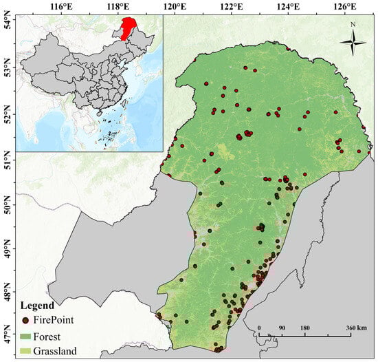
Figure 1.
Overview of the study area and spatial distribution of fire points (data source: VIIRS active fire data, 2016–2020).
The Daxing’anling region has experienced frequent fires. From 1988 to 2020, a total of 1021 forest fires were recorded, with a cumulative burned area of approximately 1232,798.42 hectares. In addition, the large-scale forest fire in 1987 burned about 1.01 million hectares, making it one of the most severe forest fires in modern Chinese history. The higher oil content in the bark and foliage of coniferous trees, compared to broadleaf species, increases their flammability, thereby facilitating the rapid ignition and spread of wildfires [37]. The forest and grassland fires occur frequently in the Daxing’anling region. In summer, lightning is the primary cause of fire ignition [38]. During spring and autumn, fires are mainly triggered by human activities in combination with extreme weather conditions such as high temperatures, strong winds, and drought [39].
2.2. Datasets
The time-series data used were obtained from the GEE platform (https://earthengine.google.com/, accessed on 1 January 2024) (Table 1). Landsat surface reflectance dataset has undergone geometric, radiometric, and atmospheric corrections. Compared with top-of-atmosphere reflectance and raw imagery, this dataset exhibits superior temporal consistency and stability, making it more suitable for long-term remote sensing studies [40]. The CFMASK algorithm was applied to mask out clouds, cloud shadows, and snow.

Table 1.
Description of data sources.
This study utilized the 30 m annual land cover product of China, developed by the Remote Sensing Institute of Wuhan University, covering the period from 1985 to 2023 (http://doi.org/10.5281/zenodo.4417809, accessed on 1 May 2024), to define the distribution of forests and grasslands within the study area. Three widely used BA products—GABAM, FireCCI51, and MCD64A1—were selected to validate the temporal trends of BA mapping. In addition, the Sentinel-2 datasets with 10 m resolution from 2015 to 2023 were used as independent high-resolution data for fine-scale spatial validation of the BA boundaries.
2.3. Technical Approach
The technical framework of this study consisted of four main components: (i) annual composite of time-series Landsat imagery, (ii) model training, (iii) burned area mapping, and (iv) fire severity mapping (Figure 2). The following sections provide a detailed description of each component.
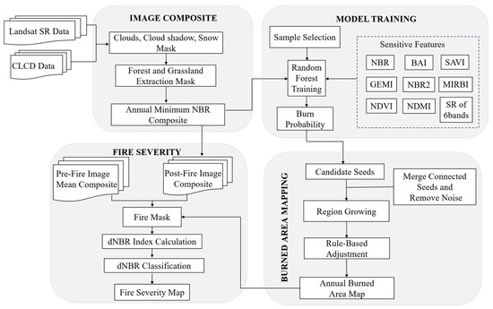
Figure 2.
Flowchart of burned area and fire severity mapping.
2.4. Annual Composite of Time-Series Landsat Imagery
The Landsat satellite acquire more than 500 scenes annually over the Daxing’anling region. Integrating these scenes into a complete and high-quality Landsat composite was a critical step in the workflow. Median compositing is widely used in BA mapping, as it is less affected by extreme values and effectively reduces noise interference in composite images [41]. In a 2005 fire case, it was observed that most BA disappeared in the median composite of the Landsat imagery. This occurs because the median compositing method selects the median value of each pixel across the time-series, which fails to capture the temporal dynamics of BA. As a result, fire-related signals may be weakened or entirely omitted in the final composite (Figure 3a).
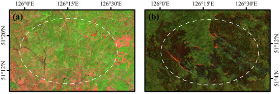
Figure 3.
Comparison of different compositing methods for Landsat time-series. (a) Landsat 5 median composite image; (b) Landsat 5 annual minimum NBR (q-NBR) composite image.
In this study, the qualityMosaic method was employed to generate annual Landsat composite imagery. This method is an automated technique that selects the best-quality pixels from a collection of images based on a specified reference band (i.e., quality band). By comparing the reference values pixels by pixels across all images, it composites a single mosaic image where each pixel comes from the scene with the highest quality. This approach effectively removes cloud and noise interference, enabling efficient and reliable large-scale image synthesis for application such as fire detection, phenology monitoring and annual maximum value composites. Given that the NBR is specifically designed for BA mapping and is widely recognized as one of the most effective and robust spectral indices—demonstrating strong performance in fire detection [42]—it was selected as the quality band in this study. Based on this, the annual minimum NBR composites were generated using the qualityMosaic (q-NBR) approach, which involved the following steps: (i) comparing the values of the designated quality band (i.e., NBR) across all images at each pixel location; and (ii) selecting the pixel from the image with the highest quality band value as the final output. This process helps maintain the spectral integrity of the composite image, ensuring its suitability as input for subsequent random forest (RF) classification.
Meanwhile, considering the long winter season and the low probability of fire occurrences in the Daxing’anling region [43], the annual compositing time window was defined as 1 March to 30 November. Figure 3b demonstrates that the Landsat data compositing strategy adopted in this study effectively delineates the extent of the BA.
2.5. Sample Design
Training samples for machine learning generated in this study by visually interpreting BA using composites images of the shortwave infrared 2 (SWIR2), near-infrared (NIR), and green bands. Unburned samples were randomly selected from built-up areas, rivers, cloud shadows, and forests or grasslands unaffected by fire. During sample selection, two key factors must be considered. First, sample quality, burned samples should ideally be selected from clear pixels that are free from cloud or shadow interference. Second, a reasonable ratio between burned and unburned samples must be maintained to avoid class imbalance, which could negatively impact model performance. Finally, a total of 4109 BA samples and 4996 unburned area samples were selected from approximately 20,000 images spanning nearly 40 years.
2.6. Feature Variable Selection
This study constructed a feature variable dataset for BA mapping based on post-fire changes in spectral characteristics of land surface features. The dataset includes surface reflectance from six spectral bands (Table 2) and a set of spectral indices (Table 3).
Table 2.
Selected bands for BA mapping using different Landsat sensors.
Table 3.
Selected features for BA remote sensing mapping.
The spectral indices are categorized into two main types: BA indices, and vegetation spectral indices. The reduction in vegetation after fire, along with the presence of charcoal and ash, causes a decline in the NIR reflectance within burned areas, as the NIR is strongly influenced by vegetation chlorophyll. The decrease in moisture content and the increase in exposed soil cover after a fire lead to higher reflectance in the SWIR2 band. The BAI is sensitive to the presence of surface charcoal and ash, while the Normalized Burned Ratio2 (NBR2) values exhibits sharp changes shortly after a fire. The vegetation indices used in this study include Normalized Difference Vegetation Index (NDVI), the Global Environmental Monitoring Index (GEMI), and the Soil-Adjusted Vegetation Index (SAVI). NDVI is widely used in BA mapping to represent vegetation health. GEMI is a vegetation activity index with broader global applicability compared to NDVI. As a nonlinear index, GEMI has been shown in some studies to be more sensitive to low reflectance values in the red and NIR spectral bands. SAVI is designed to minimize the influence of soil reflectance on vegetation indices, thereby enhancing the detectability of BA in sparsely vegetated regions. The Normalized Difference Moisture Index (NDMI) reflects the reduction in leaf moisture caused by fire-induce heat, resulting in a significant decrease in NDMI values within BA.
2.7. Random Forest Modeling
The RF model enhances overall prediction accuracy and stability by constructing an ensemble of decision trees and aggregating their outputs. It has been successfully applied in fire-related research, particularly for predicting fire occurrence, identifying factors influencing fire severity, and characterizing different fire types [49,50]. In this study, the RF algorithm provided by the GEE platform was used to train a decision tree classifier, based on a total of 4109 BA samples and 4996 unburned area samples from the Daxing’anling region. The number of decision trees was set to 150, while all other hyperparameters were kept at their default values. The input features included six reflectance bands from Landsat 8 and eight spectral indices that are sensitive to BA.
2.8. Region Growing
BA mapping was conducted in two main stages. First, pixels with high burn probabilities were identified as the core BA to reduce commission error. Second, pixels with lower burn probabilities—below the threshold used in the first stage were selected and incorporated using a region-growing method to expand the core boundaries, thereby reducing omission error.
The basic principle of the region-growing method is to cluster pixels or regions with similar characteristics in order to form larger homogeneous areas [51]. This method involved four steps: selecting candidate seeds pixels, defining growth rules, setting iteration conditions, and specifying termination criteria. The pixels with a burn probability greater than 0.9, generated by the RF model described in Section 2.7, were selected as candidate seeds, representing the core BA. Since BA typically exhibit a contiguous, patch-like distribution following a fire, it was necessary to remove isolated small patches. In each iteration, if the burn probability of any of the eight neighboring pixels of a seed pixel was greater than or equal to 0.5, it was defined as a new seed and merged with the existing set of candidate seeds. This process continued iteratively until no additional pixels met the criteria, at which point the region-growth process was terminated.
2.9. Correction of Burned Area
Forests in northern regions typically do not recover rapidly after fire [52], and the likelihood of a BA with the same shape reoccurring within a short time frame is extremely low. Therefore, if the same BA appeared again in the following year, it was considered an unrecovered area. By analyzing pre- and post-fire Landsat imagery, we observed that images from the second year were often more complete, likely due to reduce interference from clouds and smoke. Thus, the following rules were established to correct BA in forest regions: (i) set the recovery period for forests to three years; (ii) identify repeated fires occurring within this three-year period, using the first occurrence as the reference time; (iii) merge all detected fires within the three years to obtain the most complete representation of the BA; (iv) update the fire record of the first year with the newly merged burned area and mask out repeated fires in the subsequent years.
For grassland ecosystems, post-fire recovery is relatively rapid. Seasonal corrections were applied to the BA data. During grassland fires, the primary materials burn are surface dead grass and litter, which are rapidly consumed following the fire. Snow cover may bury surface dead grass and litter, thereby reducing the probability of fire occurrence during the winter months in the Daxing’anling region. The Julian date was used to categorize seasons, and the BA were selected from the autumn of the current year and the spring of the following year. If a fire occurs in the grassland during the autumn and the BA is still detected in the following spring, it is considered an unrecovered area.
2.10. Validation of Burned Area Mapping
To evaluate the accuracy and reliability of BA mapping, it is essential to incorporate independent reference data for validation. Reference datasets are commonly obtained from higher-resolution remote sensing imagery than the product under evaluation. In this study, the Sentinel-2 datasets with 10 m resolution were used to extract BA perimeters via a semi-automatic approach, which were then used as reliable reference data for validation. The Sentinel-2 imagery was first classified using a support vector machine approach, and manual visual interpretation was subsequently conducted to enhance the accuracy and clarify the extent of the BA. Due to the temporal limitations in Sentinel-2 data availability, a total of 20 representative fire events from 2015 to 2023 were selected to assess the accuracy of BA extraction.
For each fire event, a cross-tabulation of pixel assignments between our BA product and the reference data was performed to generate the confusion matrix (Table 4). From the confusion matrix, overall accuracy (OA, Equation (1)), commission errors (CE, Equation (2)), omission errors (OE, Equation (3)), and the Dice coefficient (DC, Equation (4)) were calculated. The DC summarizes both commission and omission errors, providing a measure of the overall accuracy for the target class.
Table 4.
Cross-tabulation between our BA product and the reference data.
2.11. Fire Severity
This study introduced the dNBR index to quantify fire severity. The calculation formula for the dNBR index is as follows:
where NBRprefire represents the NBR value before the fire, and NBRpostfire represents the NBR value after the fire. The pre-fire images were generated by calculating the mean value of each pixel, while the post-fire images were composed using the q-NBR method, ensuring that all fires events within the year were fully captured. Based on the classification criteria of the United States Geological Survey, the fire severity was categorized into four levels ([53]; Table 5).
Table 5.
Fire severity classification criteria.
2.12. Validation of Fire Severity Classification
Due to the absence of in situ fire severity measurements in the study area, we adopted an indirect validation approach. Specifically, previously published fire severity data for the same region, which had been validated through field surveys, were used as reference data to compare and evaluate the fire severity thresholds established in this study, thereby assessing their rationality.
This study adopted the fire severity classification thresholds proposed by Wang et al. [54], derived for the Daxing’anling region through a linear regression model linking field-based composite burn index measurements with the NBR. To verify the accuracy of our classification method, we selected ten representative fires of different sizes, as defined by the Forest Fire Prevention Regulations issued by the State Council of the People’s Republic of China. Each fire was classified using the reference thresholds, and the results were compared with those obtained in this study on a case-by-case basis. The classification accuracies for different severity levels were then calculated to evaluate the applicability of our thresholds for fire severity classification in the Daxing’anling region.
3. Results
3.1. Product Description
3.1.1. Mapping of Forest Burned Areas
The BA mapping approach proposed in this study enables high-quality monitoring of large-, medium-, and small-scale fires, based on the fire classification criteria outlined in the Forest Fire Prevention Regulations issued by the State Council of the People’s Republic of China. The representative fire cases from the study were presented to demonstrate the accuracy of the BA mapping results. Figure 4 illustrates a forest fire that occurred in Mohe City in 2015, with a total BA of 197 hectares. According to the correction rules developed, the BA was initially identified as forest land, which was characterized by a relatively slow recovery rate following fire disturbance. Therefore, if BA reappeared at the same location within a short time span, it was considered an unrecovered of the 2015 BA, rather than a newly emerged BA in 2016. Meanwhile, for the same BA, more complete boundaries were observed in the original 2016 image (Figure 4b) than in the 2015 image (Figure 4a). Based on above principles, the corresponding BA from 2015 and 2016 were merged to improve the mapping accuracy for 2015, and the overlapping burned region was masked in the 2016 dataset. Compared to the burned area detected in Figure 4c, the corrected result in Figure 4d demonstrates improved accuracy, with an additional 569 pixels identified.
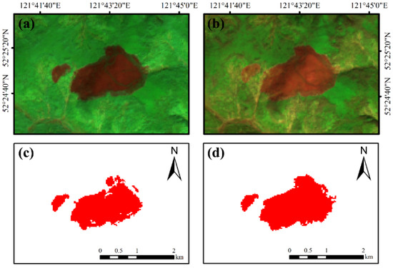
Figure 4.
Example of the BA in Mohe City in 2015. (a,b) show the Landsat 8 imagery displayed in false color composition (red: SWIR2 band, green: NIR, and blue: Green band); (c) presents the uncorrected burned area result; (d) shows the result after applying the correction rules.
A forest fire occurred in Genhe City in 2017, resulting in a burned area of 1364 hectares (Figure 5). The results of core area identification and the region-growing method were shown in Figure 5b, where both the core and peripheral BA were accurately delineated relative to the original post-fire image (Figure 5a).
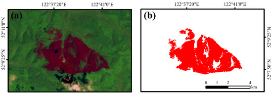
Figure 5.
Example of the BA in Genhe City in 2017. (a) post-fire Landsat 5 imagery; (b) BA mapping result produced in this study.
A BA of 7.9 hectares in Huma County in 2016 was used as a representative example (Figure 6). For the same BA, the q-NBR method (Figure 6b) identified 99 more burned pixels than the median composite method (Figure 6a), significantly enhancing mapping accuracy.
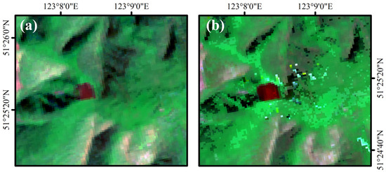
Figure 6.
Example of the BA in Huma County in 2016. (a) Landsat 5 median composite image; (b) composite image generated using the q-NBR method.
3.1.2. Correction of Grassland Burned Area
The correction results for grassland BA were shown in Figure 7. The BA from November 2001 remained visible in the spring 2002 imagery, indicating incomplete vegetation recovery (Figure 7a). According to our correction rule, the BA observed in March 2002 was considered an unrecovered portion of the 2001 fire. Figure 7b displays the corrected BA for 2002, in which burned pixels overlapping with the 2001 fire were removed, while new BA in 2002 were successfully identified.
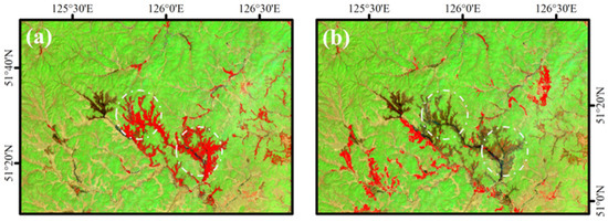
Figure 7.
Correction results of the grassland BA. (a) BA detected in 2001; (b) corrected BA in 2002 after applying the recovery rule. The base image is a Landsat 7 scene acquired in the spring of 2002.
3.2. Validation
3.2.1. Validation of Burned Area Mapping
Based on 20 representative fire events, we constructed confusion matrices and calculated four accuracy assessment metrics (Table 6). The results indicated that the method proposed in this study achieved robust performance in BA identification, with average values of OA at 93.90%, OE at 26.32%, CE at 5.25%, and the DC at 82.04%. In particular, the relatively high values of OA and DC underscored the effectiveness of the proposed strategy in accurately delineating BA.
Table 6.
Accuracy assessment metrics for 20 representative fire events.
Figure 8 presents representative validation cases, in which only BA exceeding 100 hectares were displayed. These cases clearly demonstrated that most BA were accurately delineated (DC > 80%), with the extracted results showing strong spatial agreement with the reference burn perimeters. In most cases, the OE was higher than the CE, which could be attributed to the finer spatial resolution and greater spectral sensitivity of Sentinel-2 in detecting burned features. These characteristics likely enabled the reference dataset to capture more detailed and spatially complete BA that were not identified in the Landsat imagery used in this study.
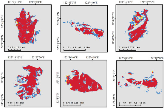
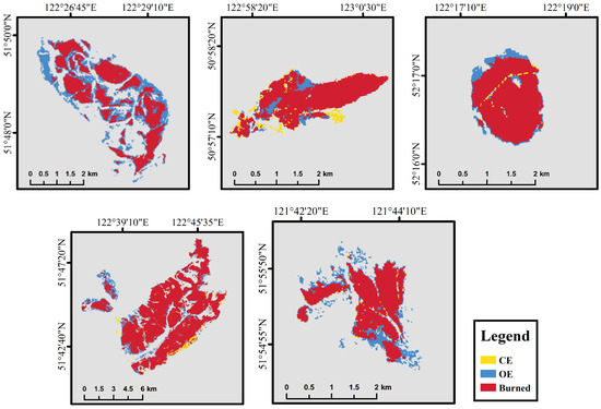
Figure 8.
Examples of validation using Sentinel-2 imagery.
3.2.2. Validation of Fire Severity Mapping
Based on the reference classification thresholds, ten representative fires of large, medium, and small scales were classified, and the results were individually compared with those derived in this study. The comparison revealed strong consistency between the two classifications, yielding an overall mean accuracy of 82.16% across all representative fires. It should be noted that the classification scheme proposed in this study comprises four severity levels, while the reference data were categorized into only three levels. For the purpose of direct comparison, the “moderate-low” and “moderate-high” classes in our system were combined into a single “moderate” category. The classification accuracies by severity level were 81.14% for low severity, 84.35% for moderate severity, and 80.99% for high severity (Table 7).
Table 7.
Classification accuracy of fire severity levels for 10 representative fires.
Covering a broad spectrum of fire scales, these ten cases yielded consistently high classification accuracies across all categories, thereby reinforcing the applicability and reliability of the fire severity thresholds established in this study for the Daxing’anling region.
3.3. Long-Term Temporal Trends of Burned Area
Time-series analysis revealed four prominent peaks in BA, occurring in 1987, 1996, 1998, and 2003 (Figure 9). The annual BA showed exhibited substantial fluctuations between 1985 and 1999, with a pronounced peak in 1987 exceeding 13,000 km2. From 2000 to 2010, the BA showed an overall declining trend. However, another significant peak occurred in 2003, with the BA surpassing 7000 km2. After 2010, the annual BA remained relatively stable, and the fire activity declined significantly. By 2020, the BA had declined to its minimum value of only 92.8 km2.
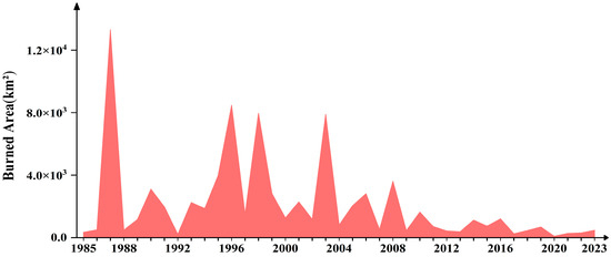
Figure 9.
Annual change in BA from 1985 to 2023.
3.4. Comparison of Different Burned Area Products
3.4.1. Comparison of Temporal Trends in Existing Burned Area Products
Figure 10 presents the annual BA trends from 2001 to 2020 as derived from four different burned area products: MCD64A1, FireCCI51, GABAM, and the Daxing’anling Burned Area (DABA) dataset. Overall, the BA products exhibited a high degree of consistency. All datasets showed significant peaks in BA in 2003 and 2008, followed by a rapid decline after 2008. Since that time, the BA has remained at relatively low levels. Compared to GABAM, which shares the same spatial resolution, the temporal trend in BA from 1985 to 2023 aligns closely with our product, particularly in years marked by major BA peaks. But the BA recorded by GABAM reached 6898 km2 in 2001, significantly exceeding that of the other three products.
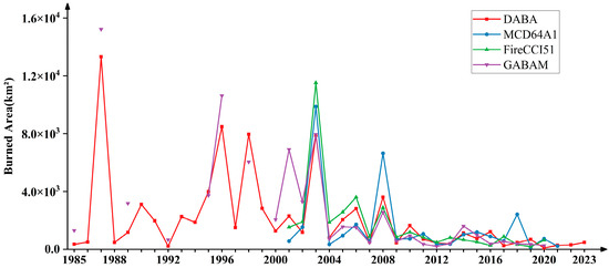
Figure 10.
Annual BA estimates from different products.
Figure 11 presents the relative discrepancies between the three BA products and the results of this study from 2001 to 2020. Overall, GABAM showed the highest consistency with our results, with a mean interannual relative discrepancy of +19.50%. In contrast, MCD64A1 and FireCCI51 exhibited larger deviations, with mean values of +56.96% and +54.78%, respectively. During 2016–2020, the fluctuations in relative discrepancies increased markedly, primarily because the relatively small BA in the study region amplified the relative differences among products. Compared with the 30 m GABAM, the coarser resolution products MCD64A1 and FireCCI51 were more affected by mixed-pixel effects when detecting small patches and boundary regions, resulting in higher relative discrepancies.
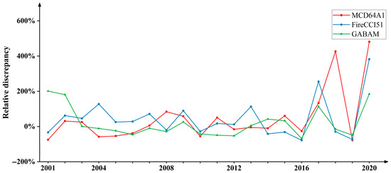
Figure 11.
Comparison of relative discrepancies between this study and three widely used BA products (2001–2020).
3.4.2. Spatial Comparison of Burned Area
Figure 12 presents examples of BA detection results from four different products. All products successfully detected the BA; however, due to differences in spatial resolutions, they exhibited varying detection results. Figure 12c,d lack spatial detail and exhibit jagged edges. Figure 12e,f show the detection results from GABAM and DABA, respectively, both based on 30 m Landsat data. Compared to the MODIS-based results from the first two products, the 30 m Landsat data showed better alignment with the actual BA. Their spatial patterns more closely resemble the post-fire damage observed in the imagery, demonstrating stronger extraction capabilities. Notably, our method extracted more BA pixels than GABAM, resulting in a more accurate representation of the BA.
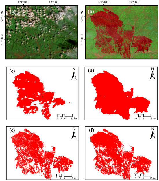
Figure 12.
Comparison of different BA products over the same spatial region. (a,b) show the pre-fire and post-fire Landsat 8 imagery; (c–f) present the BA extraction results from MCD64A1, FireCCI51, GABAM, and DABA.
3.5. Spatial and Temporal Patterns of Fire Severity
The trend in high-severity BA was closely correlated with the total annual BA. As shown in Figure 13, the proportion of high-severity burns was relatively higher in 1987, 1996, 1998, and 2003, corresponding to the four peak years of BA.
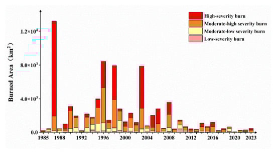
Figure 13.
BA by fire severity level.
We analyzed the occurrence frequency of four fire severity levels from 1985 to 2023: low severity (Figure 14a), moderate-low severity (Figure 14b), moderate-high severity (Figure 14c) and high severity (Figure 14d). Subsequently, hotspot analysis was applied the to conduct spatial clustering of the occurrence frequency of different fire severity levels. The results indicated significant spatial clustering in the frequency of occurrences across different fire severity levels.
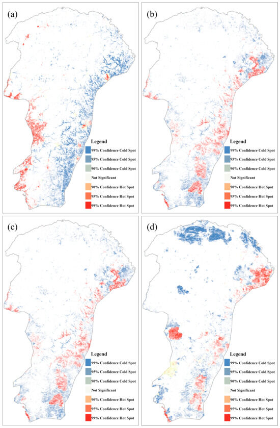
Figure 14.
Hotspot analysis of the occurrence frequency of different fire severity levels.
The hotspots associated with different fire severity occurrence frequencies were primarily concentrated along the southeastern and southwestern edges of the study area. Compared to the other fire severity levels, low-severity burns exhibited fewer hotspots along the southeastern edge zones. In contrast, cold spot regions remained relatively stable and were primarily concentrated in the northern part of the study area. High-severity burn hotspots were the most concentrated, mainly distributed in the northeastern, southeastern and western regions. These spatial patterns provide important insights into areas of high and low fire risk, highlighting regions where fire management and prevention should be prioritized. The identification of high-severity hotspots can inform targeted monitoring efforts and guide post-fire restoration, while the persistence of cold spots indicates areas with consistently low fire occurrence.
4. Discussion
We developed a BA dataset for the Daxing’anling region covering the period from 1985 to 2023, and assessed fire severity based on this dataset. This study provides one of the first comprehensive databases of burned area and fire severity in the region, derived from medium-resolution remote sensing data spanning nearly four decades. The two-stage algorithm—core area identification followed by region growing—has been proved effective in balancing omission and commission errors in BA detection [55,56].
Compared with existing BA mapping methods, the proposed approach offered a more efficient and stable solution for large-scale, long-term fire monitoring using remote sensing, without relying on any auxiliary fire information. Pereira et al. [57] and Shan et al. [58] utilized active fire data as auxiliary information for BA detection; however, the limited temporal coverage of such data often restricts its applicability to early Landsat historical imagery or future prediction scenarios. Compared with single-scene adaptive thresholding methods [59], the annual minimum NBR composite approach integrates all fires events within a given year into a single composite image, significantly enhancing the efficiency and completeness of BA detection. Furthermore, this study effectively addresses a key limitation of multi-temporal methods, which rely heavily on acquiring remote sensing images within specific pre- and post-fire time windows. Such methods often struggle to obtain suitable near-fire imagery in regions frequently affected by cloud cover or where the timing of fire events is uncertain [60].
Compared with the GABAM dataset of the same spatial resolution, the BA estimates from 1985 to 2023 indicated strong consistency in overall temporal trends and showed a high degree of agreement during peak BA years. Nevertheless, the GABAM dataset contains missing data for several years (e.g., 1990, 1991, 1993, 1994, 1996, 1997, 1998, 1999, and from 2022 onwards), which may hinder its ability to accurately capture fire dynamics during those periods and compromise the completeness of long-term trend analyses. The BA in 2001 was significantly overestimated, which may be attributed to a malfunction of the scan angle monitor on the Landsat 5 satellite, leading to internal synchronization issues. This malfunction resulted in abnormally bright observations along the scene edges in a diagonal pattern, particularly in the SWIR2 band, where elevated reflectance values triggered false detections of BA [61].
Traditional fire severity mapping methods typically relied on a single pair of pre- and post-fire Landsat images [62]. This process required careful scene selection, and identifying suitable image pairs was often time-consuming. This study employed a mean compositing method for pre-fire images to enhances data stability and reduce the influence of outliers [63]. As a result, the accuracy and stability of burned area severity assessments were significantly improved. This method provides a novel technical framework for annual fire severity mapping. The BA and fire severity mapping methods developed using GEE are applicable to other regions of interest, offering expanded opportunities for monitoring and research.
Although the methodology presented in this study offers several advancements, it also has certain limitations, such as the false positives associated with agricultural fields. The spectral characteristics of agricultural activities—particularly following harvest—often resemble those of the BA in remote sensing imagery, leading to false positives in BA detection. Despite applying a mask for agricultural areas during BA mapping in the Daxing’anling region, the interference from agricultural fields was not entirely eliminated. Therefore, further field investigations and the use of higher-resolution remote sensing data may help address the issue of agricultural false positives more effectively. Additionally, in the assessment of fire severity, due to the difficulty in obtaining field data for historical fires, the analysis relied solely on dNBR index, which lacks validation through ground-based measurements.
5. Conclusions
The present study employed the qualityMosaic method on the GEE platform to generate annual minimum NBR composites from Landsat imagery without relying on any prior data, enabling the rapid selection of fire sample points. The resulting composite images were directly used as input for random forest classification to identify the core areas of BA, significantly improving the efficiency of BA mapping. The reliability of the method was validated through mapping assessments of BA at large, medium, and small spatial scales in the Daxing’anling region. This approach provides an accurate and efficient solution for BA mapping in northern forest and temperate grassland regions. Based on independently interpreted burn perimeters from Sentinel-2 imagery, the OA of BA mapping was 93.90%, the DC was 82.04%, while the OE and CE were 26.32% and 5.25%, respectively. The relatively high values of OA and DC underscored the robustness of the proposed method in BA mapping accuracy. A comparison between the results of this study and existing products such as MCD64A1, FireCCI51, and GABAM revealed consistent overall trends and peak years in BA changes, further validating the temporal reliability of the findings. The BA exhibited significant fluctuations from 1985 to 2023, with the highest value of 13,315 km2 recorded in 1987. Since 2010, an overall declining trend has been observed, with annual burned areas remaining below 2000 km2. The proposed method demonstrated superior spatial detection capability compared to the other three products, yielding more accurate results in both core and edge areas and identifying a greater number of BA pixels. High-severity BA changes were positively correlated with annual total BA, whereas other severity levels did not show notable temporal trends. High-severity fire-prone zones were spatially concentrated in the southeastern, northeastern, and western parts of the study area, particularly in grassland and forest–grassland ecotones. However, due to the limitations of remote sensing image resolution, some uncertainties in BA mapping still remain. Future studies could integrate higher-resolution datasets and multi-source remote sensing information to further enhance the accuracy and applicability of BA mapping.
Author Contributions
Conceptualization, L.C.; data curation, Y.Z.; formal analysis, L.C.; funding acquisition, B.W. and X.J.; methodology, L.C.; resources, B.W. and X.J.; supervision, B.W. and X.J.; validation, M.L.; visualization, L.C. and M.L.; writing—original draft, L.C.; writing—review and editing, B.W. All authors have read and agreed to the published version of the manuscript.
Funding
This research was funded by the First-Class Discipline Research Special Project of Inner Mongolia (YLXKZX-NSD-040), the Natural Science Foundation of Inner Mongolia (2022LHQN04003, 2023QN04009), the Funda-mental Research Funds for the Inner Mongolia University of Finance and Economics (NCXKY25019, NCYWZ22003).
Data Availability Statement
The original contributions presented in this study are included in the article. Further inquiries can be directed to the corresponding author.
Acknowledgments
The authors thank the editor and three anonymous reviewers, who helped improve the manuscript at earlier stages.
Conflicts of Interest
The authors declare no conflict of interest.
Correction Statement
This article has been republished with a minor correction to the Data Availability Statement. This change does not affect the scientific content of the article.
References
- Roberts, G.; Wooster, M.J.; Strydom, T. Assessment and validation of Meteosat SEVIRI fire radiative power (FRP) retrievals over Kruger National Park. Int. J. Appl. Earth Obs. Geoinf. 2025, 136, 104375. [Google Scholar] [CrossRef]
- Vallet, L.; Abdallah, C.; Lauvaux, T.; Joly, L.; Ramonet, M.; Ciais, P.; Lopez, M.; Xueref-Remy, I.; Mouillot, F. Soil smoldering in temperate forests: A neglected contributor to fire carbon emissions revealed by atmospheric mixing ratios. Biogeosciences 2025, 22, 213–242. [Google Scholar] [CrossRef]
- Humber, M.L.; Boschetti, L.; Giglio, L. Assessing the Shape Accuracy of Coarse Resolution Burned Area Identifications. IEEE Trans. Geosci. Remote Sens. 2020, 58, 1516–1526. [Google Scholar] [CrossRef]
- Goodwin, N.R.; Collett, L.J. Development of an automated method for mapping fire history captured in Landsat TM and ETM+ time series across Queensland, Australia. Remote Sens. Environ. 2014, 148, 206–221. [Google Scholar] [CrossRef]
- Kurbanov, E.; Vorobev, O.; Lezhnin, S.; Sha, J.; Wang, J.; Li, X.; Cole, J.; Dergunov, D.; Wang, Y. Remote Sensing of Forest Burnt Area, Burn Severity, and Post-Fire Recovery: A Review. Remote Sens. 2022, 14, 4714. [Google Scholar] [CrossRef]
- Hawbaker, T.J.; Vanderhoof, M.K.; Beal, Y.-J.; Takacs, J.D.; Schmidt, G.L.; Falgout, J.T.; Williams, B.; Fairaux, N.M.; Caldwell, M.K.; Picotte, J.J.; et al. Mapping burned areas using dense time-series of Landsat data. Remote Sens. Environ. 2017, 198, 504–522. [Google Scholar] [CrossRef]
- Lentile, L.; Holden, Z.; Smith, A.; Falkowski, M.; Hudak, A.T.; Morgan, P.; Lewis, S.; Gessler, P.; Benson, N. Remote sensing techniques to assess active fire characteristics and post-fire effects. Int. J. Wildland Fire 2006, 15, 319–345. [Google Scholar] [CrossRef]
- Chuvieco, E.; Lizundia-Loiola, J.; Pettinari, M.L.; Ramo, R.; Padilla, M.; Tansey, K.; Mouillot, F.; Laurent, P.; Storm, T.; Heil, A.; et al. Generation and analysis of a new global burned area product based on MODIS 250 m reflectance bands and thermal anomalies. Earth Syst. Sci. Data 2018, 10, 2015–2031. [Google Scholar] [CrossRef]
- Key, C.H.; Benson, N.C. The Normalized Burn Ratio (NBR): A Landsat TM Radiometric Measure of Burn Severity; US Geological Survey Northern Rocky Mountain Science Center: Bozeman, MT, USA, 2003.
- Chuvieco, E.; Martín, M.P. Cartografía de grandes incendios forestales en la Península Ibérica a partir de imágenes NOAA-AVHRR. Ser. Geogr. 1998, 7, 109–128. Available online: http://hdl.handle.net/10261/6426 (accessed on 17 August 2025).
- Trigg, S.; Flasse, S. An evaluation of different bi-spectral spaces for discriminating burned shrub-savannah. Int. J. Remote Sens. 2001, 22, 2641–2647. [Google Scholar] [CrossRef]
- Smiraglia, D.; Filipponi, F.; Mandrone, S.; Tornato, A.; Taramelli, A. Agreement Index for Burned Area Mapping: Integration of Multiple Spectral Indices Using Sentinel-2 Satellite Images. Remote Sens. 2020, 12, 1862. [Google Scholar] [CrossRef]
- Alcaras, E.; Costantino, D.; Guastaferro, F.; Parente, C.; Pepe, M. Normalized Burn Ratio Plus (NBR+): A New Index for Sentinel-2 Imagery. Remote Sens. 2022, 14, 1727. [Google Scholar] [CrossRef]
- Pleniou, M.; Koutsias, N. Sensitivity of spectral reflectance values to different burn and vegetation ratios: A multi-scale approach applied in a fire affected area. ISPRS J. Photogramm. Remote Sens. 2013, 79, 199–210. [Google Scholar] [CrossRef]
- Reilly, M.J.; Zuspan, A.; Yang, Z. Characterizing post-fire delayed tree mortality with remote sensing: Sizing up the elephant in the room. Fire Ecol. 2023, 19, 64. [Google Scholar] [CrossRef]
- Fan, J.; Yao, Y.; Tang, Q.; Zhang, X.; Xu, J.; Yu, R.; Liu, L.; Xie, Z.; Ning, J.; Zhang, L. A Hybrid Index for Monitoring Burned Vegetation by Combining Image Texture Features with Vegetation Indices. Remote Sens. 2024, 16, 1539. [Google Scholar] [CrossRef]
- Junpen, A.; Roemmontri, J.; Boonman, A.; Cheewaphongphan, P.; Thao, P.T.; Garivait, S. Spatial and Temporal Distribution of Biomass Open Burning Emissions in the Greater Mekong Subregion. Climate 2020, 8, 90. [Google Scholar] [CrossRef]
- Li, X.; Peng, Q.; Shen, R.; Xu, W.; Qin, Z.; Lin, S.; Ha, S.; Kong, D.; Yuan, W. Long-term reconstructed vegetation index dataset in China from fused MODIS and Landsat data. Sci. Data 2025, 12, 152. [Google Scholar] [CrossRef] [PubMed]
- Koutsias, N.; Pleniou, M. A rule-based semi-automatic method to map burned areas in Mediterranean using Landsat images—Revisited and improved. Int. J. Digit. Earth 2021, 14, 1602–1623. [Google Scholar] [CrossRef]
- Roteta, E.; Bastarrika, A.; Franquesa, M.; Chuvieco, E. Landsat and Sentinel-2 Based Burned Area Mapping Tools in Google Earth Engine. Remote Sens. 2021, 13, 816. [Google Scholar] [CrossRef]
- Liu, J.; Heiskanen, J.; Maeda, E.E.; Pellikka, P.K.E. Burned area detection based on Landsat time series in savannas of southern Burkina Faso. Int. J. Appl. Earth Obs. Geoinf. 2018, 64, 210–220. [Google Scholar] [CrossRef]
- Roteta, E.; Bastarrika, A.; Padilla, M.; Storm, T.; Chuvieco, E. Development of a Sentinel-2 burned area algorithm: Generation of a small fire database for sub-Saharan Africa. Remote Sens. Environ. 2019, 222, 1–17. [Google Scholar] [CrossRef]
- Grégoire, J.M.; Tansey, K.; Silva, J.M.N. The GBA2000 initiative: Developing a global burnt area database from SPOT-VEGETATION imagery. Int. J. Remote Sens. 2003, 24, 1369–1376. [Google Scholar] [CrossRef]
- Simon, M.; Plummer, S.; Fierens, F.; Hoelzemann, J.J.; Arino, O. Burnt area detection at global scale using ATSR-2: The GLOBSCAR products and their qualification. J. Geophys. Res. 2004, 109, 1–16. [Google Scholar] [CrossRef]
- Giglio, L.; Loboda, T.; Roy, D.P.; Quayle, B.; Justice, C.O. An active-fire based burned area mapping algorithm for the MODIS sensor. Remote Sens. Environ. 2009, 113, 408–420. [Google Scholar] [CrossRef]
- Ramo, R.; Roteta, E.; Bistinas, I.; van Wees, D.; Bastarrika, A.; Chuvieco, E.; van der Werf, G.R. African burned area and fire carbon emissions are strongly impacted by small fires undetected by coarse resolution satellite data. Proc. Natl. Acad. Sci. USA 2021, 118, e2011160118. [Google Scholar] [CrossRef]
- Liu, P.; Liu, Y.; Guo, X.; Zhao, W.; Wu, H.; Xu, W. Burned area detection and mapping using time series Sentinel-2 multispectral images. Remote Sens. Environ. 2023, 296, 113753. [Google Scholar] [CrossRef]
- Alencar, A.A.C.; Arruda, V.L.S.; Silva, W.V.; Conciani, D.E.; Costa, D.P.; Crusco, N.; Duverger, S.G.; Ferreira, N.C.; Franca-Rocha, W.; Hasenack, H.; et al. Long-Term Landsat-Based Monthly Burned Area Dataset for the Brazilian Biomes Using Deep Learning. Remote Sens. 2022, 14, 2510. [Google Scholar] [CrossRef]
- Hawbaker, T.J.; Vanderhoof, M.K.; Schmidt, G.L.; Beal, Y.-J.; Picotte, J.J.; Takacs, J.D.; Falgout, J.T.; Dwyer, J.L. The Landsat Burned Area algorithm and products for the conterminous United States. Remote Sens. Environ. 2020, 244, 111801. [Google Scholar] [CrossRef]
- Pereira, A.A.; Libonati, R.; Rodrigues, J.A.; Nogueira, J.; Santos, F.L.M.; Oom, D.; Sanches, W.; Alvarado, S.T.; Pereira, J.M.C. Multi-Sensor, Active Fire-Supervised, One-Class Burned Area Mapping in the Brazilian Savanna. Remote Sens. 2021, 13, 4005. [Google Scholar] [CrossRef]
- Zhang, S.; Bai, M.; Wang, X.; Peng, X.; Chen, A.; Peng, P. Remote sensing technology for rapid extraction of burned areas and ecosystem environmental assessment. PeerJ 2023, 11, e14557. [Google Scholar] [CrossRef] [PubMed]
- Guo, Q.; Su, Y.; Hu, T. Chapter 12—Forest Dynamics Monitoring. In LiDAR Principles, Processing and Applications in Forest Ecology; Guo, Q., Su, Y., Hu, T., Eds.; Academic Press: San Diego, CA, USA, 2023; pp. 379–406. [Google Scholar]
- Davis, K.T.; Robles, M.D.; Kemp, K.B.; Higuera, P.E.; Chapman, T.; Metlen, K.L.; Peeler, J.L.; Rodman, K.C.; Woolley, T.; Addington, R.N.; et al. Reduced fire severity offers near-term buffer to climate-driven declines in conifer resilience across the western United States. Proc. Natl. Acad. Sci. USA 2023, 120, e2208120120. [Google Scholar] [CrossRef] [PubMed]
- Key, C.H.; Benson, N.C. Landscape Assessment:Sampling and Analysis Methods; USDA Forest Service, Rocky Mountain Research Station: Ogden, UT, USA, 2006.
- García-Llamas, P.; Suárez-Seoane, S.; Fernández-Guisuraga, J.M.; Fernández-García, V.; Fernández-Manso, A.; Quintano, C.; Taboada, A.; Marcos, E.; Calvo, L. Evaluation and comparison of Landsat 8, Sentinel-2 and Deimos-1 remote sensing indices for assessing burn severity in Mediterranean fire-prone ecosystems. Int. J. Appl. Earth Obs. Geoinf. 2019, 80, 137–144. [Google Scholar] [CrossRef]
- Lin, S.; Li, L.; Liu, S.; Yang, S.; Lin, D.; Zhao, X.; Chen, L.; Huang, H. Predicting post-fire forest recovery using the 3-PG model with bi-temporal Landsat imagery in high-severity burned areas of Great Xing’an Mountain. For. Ecol. Manag. 2024, 563, 121991. [Google Scholar] [CrossRef]
- Popović, Z.; Bojović, S.; Marković, M.; Cerdà, A. Tree species flammability based on plant traits: A synthesis. Sci. Total Environ. 2021, 800, 149625. [Google Scholar] [CrossRef]
- Tian, X.; Cui, W.; Shu, L.; Zong, X. Effects of Climate Change on Burn Probability of Forests in Daxing’anling. Forests 2019, 10, 611. [Google Scholar] [CrossRef]
- Wang, J.; Ding, Y.; Gao, Z.; Lyu, H.; Shi, L. Exploring the spatio-temporal variations and forest restoration of burned zones in the Great Xing’an Range based on MODIS time series data. Remote Sens. Nat. Resour. 2024, 36, 142–150. [Google Scholar] [CrossRef]
- Crawford, C.J.; Roy, D.P.; Arab, S.; Barnes, C.; Vermote, E.; Hulley, G.; Gerace, A.; Choate, M.; Engebretson, C.; Micijevic, E.; et al. The 50-year Landsat collection 2 archive. Sci. Remote Sens. 2023, 8, 100103. [Google Scholar] [CrossRef]
- Silva-Cardoza, A.I.; Vega-Nieva, D.J.; Briseño-Reyes, J.; Briones-Herrera, C.I.; López-Serrano, P.M.; Corral-Rivas, J.J.; Parks, S.A.; Holsinger, L.M. Evaluating a New Relative Phenological Correction and the Effect of Sentinel-Based Earth Engine Compositing Approaches to Map Fire Severity and Burned Area. Remote Sens. 2022, 14, 3122. [Google Scholar] [CrossRef]
- Liu, D.; Qu, Y.; Yang, X.; Zhao, Q. TSSA-NBR: A Burned Area Extraction Method Based on Time-Series Spectral Angle with Full Spectral Shape. Remote Sens. 2025, 17, 2283. [Google Scholar] [CrossRef]
- Ban, Q.; Wang, Y.; Zhang, H. Study on spatio-temporal dynamic characteristics of forest fires in Daxing’an Mountains, Inner Mongolia. J. For. Eng. 2024, 9, 116–123. [Google Scholar] [CrossRef]
- Lutes, D.C.; Keane, R.E.; Caratti, J.F.; Key, C.H.; Benson, N.C.; Sutherland, S.; Gangi, L.J. Firemon: Fire Effects Monitoring and Inventory System; Department of Agriculture, Forest Service, Rocky Mountain Research Station: Fort Collins, CO, USA, 2006.
- Stroppiana, D.; Boschetti, M.; Zaffaroni, P.; Brivio, P.A. Analysis and Interpretation of Spectral Indices for Soft Multicriteria Burned-Area Mapping in Mediterranean Regions. IEEE Geosci. Remote Sens. Lett. 2009, 6, 499–503. [Google Scholar] [CrossRef]
- Pinty, B.; Verstraete, M.M. GEMI: A non-linear index to monitor global vegetation from satellites. Vegetatio 1992, 101, 15–20. [Google Scholar] [CrossRef]
- Huete, A.R. A soil-adjusted vegetation index (SAVI). Remote Sens. Environ. 1988, 25, 295–309. [Google Scholar] [CrossRef]
- Wilson, E.H.; Sader, S.A. Detection of forest harvest type using multiple dates of Landsat TM imagery. Remote Sens. Environ. 2002, 80, 385–396. [Google Scholar] [CrossRef]
- Lee, K.; Byeongcheol, K.; Park, S. Evaluating the potential of burn severity mapping and transferability of Copernicus EMS data using Sentinel-2 imagery and machine learning approaches. GISci. Remote Sens. 2023, 60, 2192157. [Google Scholar] [CrossRef]
- Makowski, D. Simple random forest classification algorithms for predicting occurrences and sizes of wildfires. Extremes 2023, 26, 331–338. [Google Scholar] [CrossRef]
- Sali, M.; Piaser, E.; Boschetti, M.; Brivio, P.A.; Sona, G.; Bordogna, G.; Stroppiana, D. A Burned Area Mapping Algorithm for Sentinel-2 Data Based on Approximate Reasoning and Region Growing. Remote Sens. 2021, 13, 2214. [Google Scholar] [CrossRef]
- Su, W.; Zhang, C.; Deng, Y.; Zhai, D.; Zhang, M.; Li, S.; Li, F.; Tang, Z.; Lin, L. Assessment of vegetation recovery dynamics over nearly 40 years in the Jizu Mountain burnt area based on Landsat imagery. Acta Ecol. Sin. 2025, 45, 1362–1378. [Google Scholar] [CrossRef]
- Key, C.; Benson, N. Landscape Assessment: Ground Measure of Severity, the Composite Burn Index and Remote Sensing of Severity, the Normalized Burn Ratio; USDA Forest Service: Washington, DC, USA, 2006; pp. L1–L51.
- Wang, X.; Wang, W.; Chang, Y.; Feng, Y.; Chen, H.; Hu, Y.; Chi, J. Fire severity of burnt area in Huzhong forest region of Great Xing’an Mountains, Northeast China based on normalized burn ratio analysis. Chin. J. Appl. Ecol. 2013, 24, 967–974. Available online: https://www.cjae.net/CN/Y2013/V24/I4/967 (accessed on 17 August 2025).
- Long, T.; Zhang, Z.; He, G.; Jiao, W.; Tang, C.; Wu, B.; Zhang, X.; Wang, G.; Yin, R. 30 m Resolution Global Annual Burned Area Mapping Based on Landsat Images and Google Earth Engine. Remote Sens. 2019, 11, 489. [Google Scholar] [CrossRef]
- Bastarrika, A.; Chuvieco, E.; Martín, M.P. Mapping burned areas from Landsat TM/ETM+ data with a two-phase algorithm: Balancing omission and commission errors. Remote Sens. Environ. 2011, 115, 1003–1012. [Google Scholar] [CrossRef]
- Pereira, A.A.; Pereira, J.M.C.; Libonati, R.; Oom, D.; Setzer, A.W.; Morelli, F.; Machado-Silva, F.; De Carvalho, L.M. Burned Area Mapping in the Brazilian Savanna Using a One-Class Support Vector Machine Trained by Active Fires. Remote Sens. 2017, 9, 1161. [Google Scholar] [CrossRef]
- Shan, T.; Wei, Z.; Jie, C.; Tang, S. A burned area mapping method for the FY-3D MERSI based on the single-temporal L1 data and multi-temporal daily active fire products. Int. J. Remote Sens. 2021, 42, 1292–1310. [Google Scholar] [CrossRef]
- Duan, Q.; Liu, R.; Chen, J.; Wei, X.; Liu, Y.; Zou, X. Burned area detection from a single satellite image using an adaptive thresholds algorithm. Int. J. Digit. Earth 2024, 17, 2376275. [Google Scholar] [CrossRef]
- Zidane, I.; Lhissou, R.; Bouli, A.; Mabrouki, M. An improved algorithm for mapping burnt areas in the Mediterranean forest landscape of Morocco. J. For. Res. 2019, 30, 981–992. [Google Scholar] [CrossRef]
- Kouachi, M.E.; Khairoun, A.; Moghli, A.; Rahmani, S.; Mouillot, F.; Baeza, M.J.; Moutahir, H. Forty-Year Fire History Reconstruction from Landsat Data in Mediterranean Ecosystems of Algeria following International Standards. Remote Sens. 2024, 16, 2500. [Google Scholar] [CrossRef]
- Lee, K.; van Leeuwen, W.J.D.; Gillan, J.K.; Falk, D.A. Examining the Impacts of Pre-Fire Forest Conditions on Burn Severity Using Multiple Remote Sensing Platforms. Remote Sens. 2024, 16, 1803. [Google Scholar] [CrossRef]
- Parks, S.A.; Holsinger, L.M.; Voss, M.A.; Loehman, R.A.; Robinson, N.P. Mean Composite Fire Severity Metrics Computed with Google Earth Engine Offer Improved Accuracy and Expanded Mapping Potential. Remote Sens. 2018, 10, 879. [Google Scholar] [CrossRef]


Disclaimer/Publisher’s Note: The statements, opinions and data contained in all publications are solely those of the individual author(s) and contributor(s) and not of MDPI and/or the editor(s). MDPI and/or the editor(s) disclaim responsibility for any injury to people or property resulting from any ideas, methods, instructions or products referred to in the content. |
© 2025 by the authors. Licensee MDPI, Basel, Switzerland. This article is an open access article distributed under the terms and conditions of the Creative Commons Attribution (CC BY) license (https://creativecommons.org/licenses/by/4.0/).