Article

Impact of Post-Fire Rehabilitation Treatments on Forest Soil Infiltration in Mediterranean Landscapes: A Two-Year Study

by
Nikolaos D. Proutsos
1,*,
Stefanos P. Stefanidis
2,
Alexandra D. Solomou
1,
Panagiotis Michopoulos
1,
Athanasios Bourletsikas
1 and
Panagiotis Lattas
3
1
Institute of Mediterranean Forest Ecosystems, Hellenic Agricultural Organization-DIMITRA, 11528 Athens, Greece
2
Forest Research Institute, Hellenic Agricultural Organization-DIMITRA, Vasilika, 57006 Thessaloniki, Greece
3
Forest Department of Pyrgos, Forests Directorate General of Ilia, 42 Alfiou, 21731 Pyrgos, Greece
*
Author to whom correspondence should be addressed.
Fire 2025, 8(7), 269; https://doi.org/10.3390/fire8070269
Submission received: 1 May 2025 / Revised: 22 June 2025 / Accepted: 4 July 2025 / Published: 6 July 2025

Abstract

In the Mediterranean region, the high frequency of fire events is combined with climatic conditions that hinder vegetation recovery. This underscores the urgent need for a post-fire restoration of natural ecosystems and implementation of emergency rehabilitation measures to prevent further degradation. In this study, we investigated the performance of three types of erosion control structures (log dams, log barriers, and wattles), two years after fire, in three Mediterranean areas that were burnt by severe forest fires in 2021. The wooden structures’ ability to infiltrate precipitation was evaluated by 100 infiltration experiments in 25 plots, one and two years after the wildfires. The unsaturated hydraulic conductivity K was determined at two zones formed between consecutive wooden structures, i.e., the erosion zone (EZ) where soil erosion occurs, and the deposition zone (DZ) where the soil sediment is accumulated. These zones showed significant differences concerning their hydraulic behavior, with DZ presenting enhanced infiltration ability by 130 to 300% higher compared to EZ, during both years of measurements. The findings suggest that the implementation of emergency restoration actions after a wildfire can highly affect the burned forest soils’ ability to infiltrate water, preventing surface runoff and erosion, whereas specific structures such as the log dams can be even more effective.

1. Introduction

Wildfires are a recurrent and devastating phenomenon in Mediterranean forest ecosystems [1,2,3], profoundly impacting soil properties, hydrological processes, and the ecosystem’s overall health. The Mediterranean Basin is particularly vulnerable due to its climatic conditions characterized by mild, wet winters, hot, dry summers [4,5,6], and intense drought events [7], coupled with highly flammable vegetation and complex topography [8,9]. In recent decades, the more pronounced effect of climate change has significantly increased the number and intensity of wildfires and, as a result, the degree of soil degradation and erosion [10,11].
The loss of vegetation cover after fire promotes the development of hydrophobic layers on the soil surface, decreasing the ability of the soil to infiltrate and store water [12,13,14], thereby increasing surface runoff. However, post-fire soil water repellency has been observed to be transient and sensitive to environmental conditions, especially rainfall. Rainfall events can potentially disrupt or even eliminate hydrophobicity by enhanced soil wetness and the microbial breakdown of hydrophobic substances. Several studies have demonstrated that intense or repeated rain can lead to the partial or total failure of hydrophobic coatings, depending on the soil characteristics, fire severity, and antecedent moisture levels [15,16].
Wildfires impact several ecosystem processes and functions, including carbon uptake and sequestration, nutrient availability and soil fertility, microbial activity, water infiltration and storage capacity, other hydrological processes, and soil texture [17]. Such changes highly degrade significant ecosystem services, including climate regulation, nutrient cycles and soil fertility, water retention and water quality, and regulation of the frequency of extreme events, etc. [17].
High burn severity is associated with wildfires and stressful climatic conditions in the Mediterranean, as well as a slow ecosystem recovery. Rehabilitation actions are thus essential to prevent further degradation and support rapid soil recovery [18]. Appropriate restoration techniques and activities should be foreseen in a management plan that must be tailored in response to the specific needs of burned areas [19,20,21]. Franco et al. [17] categorized post-fire management interventions into three main categories:
  • Emergency Soil Stabilization Measures, to be implemented within one year after the fire.
  • Rehabilitation Efforts, to support the natural regeneration of the ecosystems, which should be carried out 1–3 years post-fire.
  • Restoration Measures, which focus on the total recovery and restoration of ecosystem productivity and resilience and should be implemented over three years after the wildfire.
Among the emergency post-fire urgent treatments to control soil erosion is the construction of log barriers, log dams, and wattles [22]. These structures stabilize soil, reduce erosion, and enhance water infiltration by improving soil porosity and permeability. They also trap sediments and seeds [23] supporting natural regeneration and ecosystem recovery [24].
Multiple studies across different regions and ecosystems affected by wildfires suggest a consistent pattern of reduced hydraulic conductivity and infiltration rates in burned soils, highlighting the widespread impact of wildfires on soil hydrological properties [25,26,27]. Studies on the effects of wildfires on Mediterranean forest soils are limited [17,28,29,30,31,32,33,34], and those focusing on soil hydraulic properties of burnt soils—especially using direct infiltration measurements—are even fewer [35,36,37]. In some studies, comparisons between burned and unburned areas were performed to assess the fire’s effects on soil infiltration rates [38,39,40]. However, this is only practical when fires are planned and controlled, like in prescribed burns [41]. In the case of large wildfires, it is not feasible to find neighboring unburned areas with similar microclimatic conditions (slope, soil type, and vegetation) that have not experienced the same fire severity. Fire severity, which is the main factor determining the hydraulic behavior of the burned soils [42,43,44], can produce different effects on the soil’s ability to infiltrate water.
Understanding the changes in soil infiltration post-fire and the effectiveness of rehabilitation measures is crucial for adopting proper forest management practices to mitigate the long-term impacts of wildfires [45]. The post-fire changes in the soil’s ability to infiltrate water are important, since the absence of vegetation cover and the decrease in the water infiltration capacity enhance the risk for extensive surface runoff that promotes erosion and flash floods. The severity of the wildfires significantly alters soil texture, negatively impacting its infiltration capacity [46]. Post-fire soil stabilization is thus critical since infiltration is reduced due to the high fire temperatures and the destruction of the vegetation cover. As vegetation recovers, the infiltration rates become higher [47], due to the development of the root system of the plants [48,49].
This work aims to investigate the impact of different types of rehabilitation structures (log dams, log barriers, and wattles) installed in burned forest areas in Greece through the study of the changes in the soil’s unsaturated hydraulic conductivity, one and two years after installation. This study follows a previous work by Proutsos et al. [50] who investigated the micrometeorological and hydraulic properties of burned areas one year after the construction of the rehabilitation structures in the same study sites. In the present study, infiltration measurements during the first and the second years after the wildfires were analyzed to monitor year-to-year changes in soil hydraulic conductivity at the constantly changing and unstable post-fire environment of the burned forests, also including soil texture and vegetation parameters. To the best of the authors’ knowledge, this is the first study to comprehensively compare infiltration rates at the two zones developed between consecutive rehabilitation work units, i.e., the deposition zone, near the rehabilitation structure, and the uphill erosion zone. By monitoring the unsaturated hydraulic conductivity (K) in these zones, for different types of rehabilitation structures, over two consecutive years, this research provides valuable insights into the effectiveness of different restoration strategies in enhancing soil infiltration and mitigating post-fire erosion. The findings are expected to reform future restoration practices and contribute to the development of resilient forest management approaches in post-fire Mediterranean landscapes. The working hypothesis here is that rehabilitation improves soil infiltration capacity over time, with higher infiltration rates expected in the deposition zones compared to the erosion zones, and that these effects differ depending on the type of structure used. The main objective of this study is to quantify changes in unsaturated hydraulic conductivity (K) in the deposition and erosion zones that develop between consecutive units of post-fire rehabilitation structures over two years. Specifically, we aim to assess the following: (i) whether deposition zones—where sediment accumulates near the structures—exhibit improved infiltration compared to the adjacent erosion zones and (ii) whether these effects vary by structure type (wattles, log barriers, log dams).
The findings of the current study are of particular relevance to forest engineers, hydrologists, and land management practitioners engaged in post-fire restoration. By quantifying the effectiveness of different rehabilitation structures on the infiltration of soil in erosion- and sedimentation-affected areas, this research provides empirical data that supports informed decision making and spatial planning of this practice, taking into account site-specific features like slope, soil, and expected runoff patterns. The main findings of this research can be used as a guide to help inform decisions on the choice and coordination of structures applied, especially in the fire-prone Mediterranean conditions, where water infiltration improvement and erosion control are essential to ensure ecological rehabilitation.

2. Materials and Methods
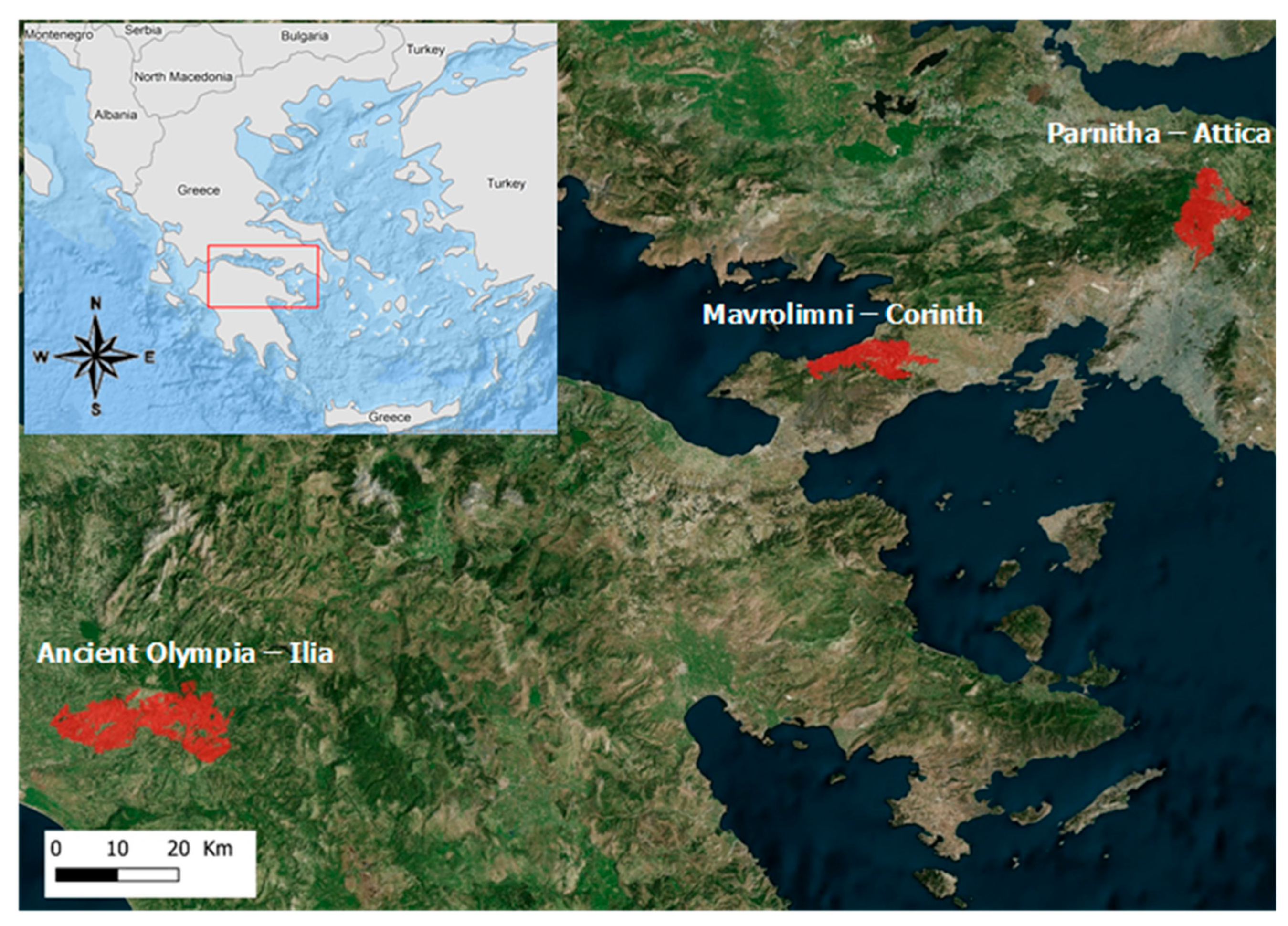
2.1. Study Sites

This study is focused on infiltration experiments conducted during the summers of 2022 and 2023 at three forest sites in Greece that were affected by wildfires during the summer of 2021 (https://goffi.web.auth.gr/ (accessed on 1 March 2025). These sites are situated within three central Greek prefectures, and their specific locations are illustrated in Figure 1.
The site located in Parnitha, Attica (38°10′50″ N, 23°47′57″ E, Alt.: 621 m), was impacted by a widespread wildfire on 3 August 2021 (Figure 2), which consumed approximately 8000 hectares [51]. This coniferous forest endures a semi-arid climate [5,6]. Long-term meteorological data (1956–2018) from the nearest station in Tatoi (38°6′ N, 23°47′ E, Altitude: 235 m), operated by the Hellenic Meteorological Service (HNMS), indicate an average annual temperature of 16.0 ± 0.6 °C. Seasonal temperatures range from 8.0 ± 0.9 °C in winter to 25.0 ± 0.9 °C in summer, with 16.9 ± 0.9 °C in autumn and 14.1 ± 1.0 °C in spring. Annual precipitation averages 534 ± 101 mm, aligning with the Mediterranean climate’s typical seasonal distribution, predominantly in winter (39.3%) and autumn (29.6%), and less so in spring (19.7%) and summer (6.8%). The region experiences a dry period of approximately 5.5 months annually.
According to the CORINE Land Cover (CLC) data from 2018, the wildfire in Parnitha primarily affected transitional woodland/shrub areas (1946 ha), mixed forests (1751 ha), agricultural areas (694 ha), and coniferous forests (1232 ha).
The site in Mavrolimni, Peloponnese (38°3′24″ N, 23°6′0″ E, Alt.: 200 m), is also a coniferous forest and was affected by a fire on 19 May 2021 (Figure 3). The fire damaged 6407 hectares, predominantly coniferous forests (4120 ha). The local climate is semi-arid [5,6], with an average annual rainfall of 410 mm between 1960 and 1997, showing a decrease from the earlier period of 1930–1960 (456 mm), based on records from the nearest station in Corinth (37.93° N, 22.95° E, Altitude: 14 m) managed by the HNMS.
The site at Ancient Olympia in Western Greece (37°42′29″ N, 21°41′48″ E, Alt.: 712 m) experienced a devastating fire from 4 to 8 August 2021, destroying 18,135 hectares (Figure 4). The primary damages were found on agricultural land (11,365 ha), transitional woodland/shrub areas (2373 ha), mixed forests (2235 ha), sclerophyllous vegetation (1539 ha), and coniferous forests (464 ha). This area is classified as having a humid Mediterranean climate according to Proutsos et al. [5], and Tsiros et al. [6], with annual rainfall averaging 921 mm for the period 1960–1997, as recorded by the nearest HNMS station in Pyrgos (37.67° N, 21.43° E, Altitude: 13 m).

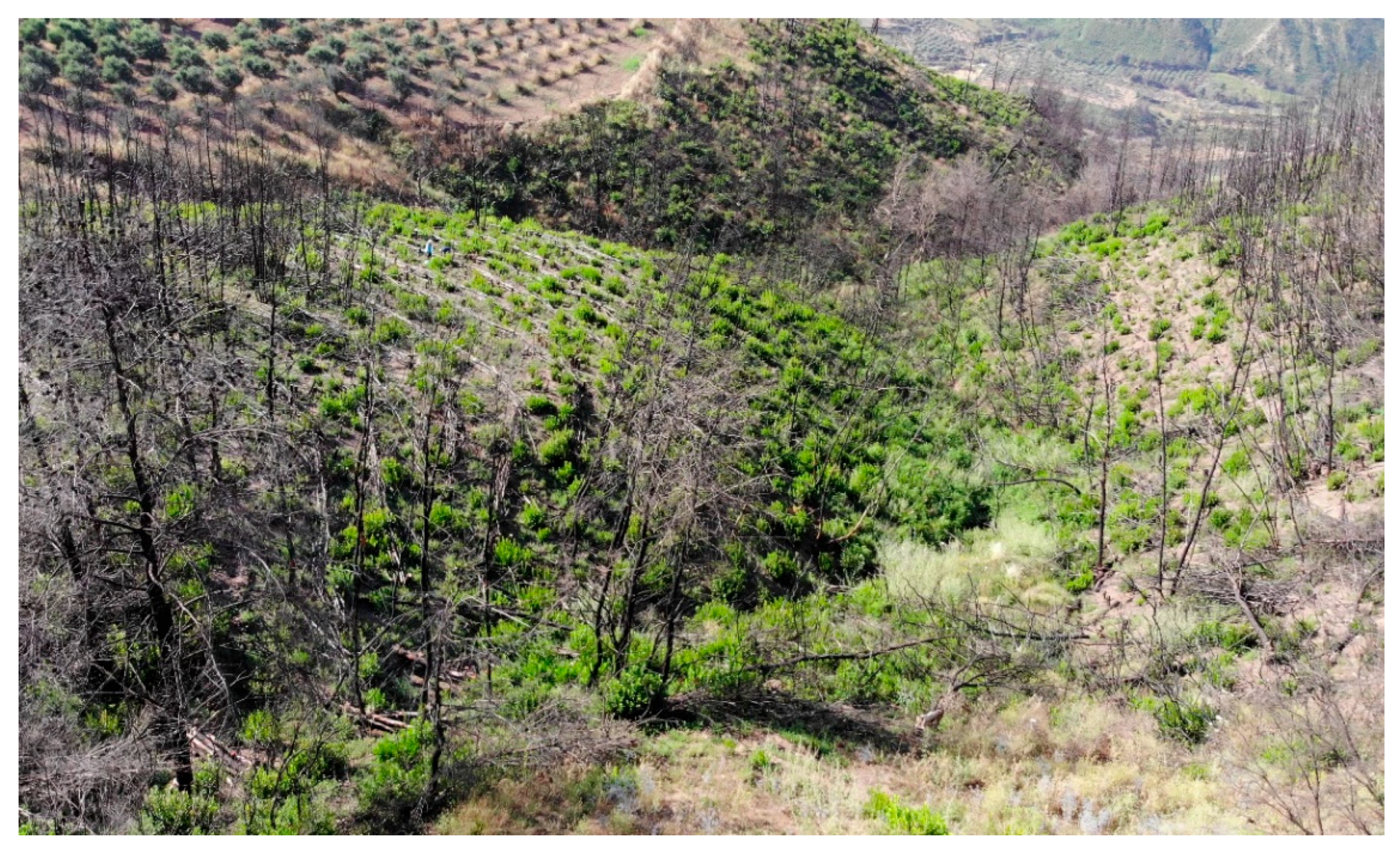
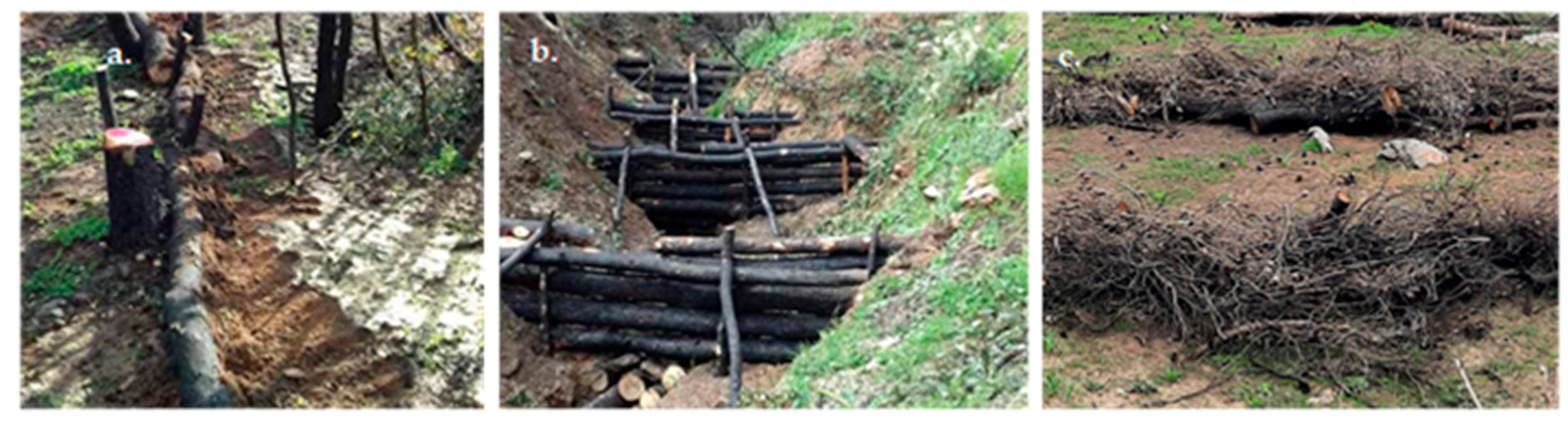
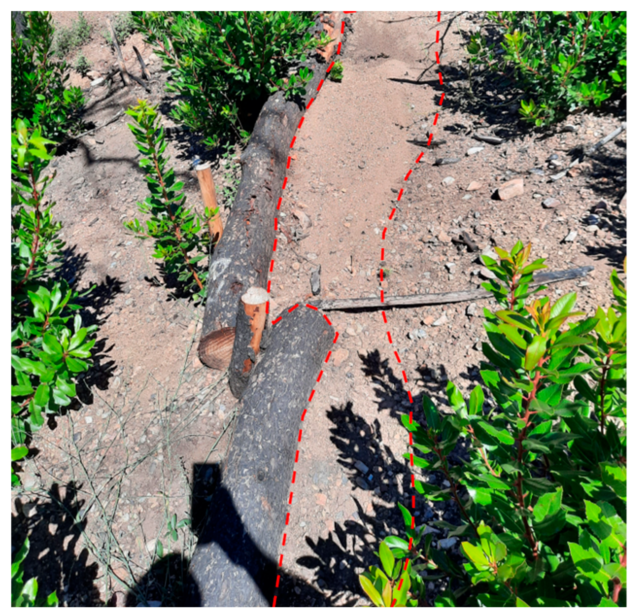
2.2. Experimental Plots

A total of 25 experimental plots were established in the summer of 2022 across the three study sites following the construction of rehabilitation works, which was implemented by the National Forest Service. These works include nine plots in Parnitha, seven in Mavrolimni, and nine in Ancient Olympia, tailored to the specific restoration methods applied: wattles, log barriers, and log dams. Specifically, seven plots were dedicated to wattles (three in Parnitha and four in Mavrolimni) and nine each to log barriers and log dams, spread equally across all sites. The plots, situated on slopes, varied in steepness from 19° in Parnitha to 27° in Ancient Olympia, regardless of the restoration method employed. The specific geographical, topographic, and geological characteristics of the sites are depicted in Table 1 along with the type of rehabilitation structure in each plot. For the identification of the parental rock, the soil map of the Hellenic Ministry of Environment was employed (https://mapsportal.ypen.gr/maps/289 (accessed on 4 November 2024).
Wattles, log barriers, and log dams (indicative types are shown in Figure 5) are wooden constructions that can slow water flow and promote sediment deposition, effectively reducing erosion and improving soil water infiltration. Wattles are small, temporary structures made of piled wooden branches, placed on shallow slopes, whereas log barriers are log structures placed perpendicular to the slopes usually installed on greater slopes. Finally, log dams are structures built across streams or channels using logs or woody debris. In all cases, the structures are constructed to retain runoff and prevent the transfer of soil particles through erosion, and their size varies according to the specific site characteristics concerning slope and type of soil.
At the above-mentioned rehabilitation types of works, the experimental plots were installed. Each plot was defined as the area between two consecutive rehabilitation work units, where two different zones are formed: the erosion zone (EZ), where soil erosion occurs due to precipitation, and the deposition zone (DZ), where sediment accumulates. The plots’ length (distance between two consecutive rehabilitation work units) was varied, being smaller (4.2 m) in Ancient Olympia, where the rehabilitation work units were applied with higher density, and higher in Parnitha (7.0 m on average), where the construction was sparser. The formation of the DZ was determined easily by eye, as is depicted in Figure 6.

2.3. Infiltration Experiments and Methods

Separate infiltration experiments were carried out in both zones of all plots during 1 or 2-day campaigns in the summers of 2022 and 2023, using a mini-disk infiltrometer (Meter Group, Mini Disk Infiltrometer, Decagon Devices Inc., Pullman, Washington, USA) to determine the unsaturated hydraulic conductivity (K) of the soils, according to the proposed methodology of Zhang [52] also described in Proutsos et al. [53], considering the soil type in each zone.
According to Zhang [52] the mini-disk infiltrometer method is appropriate for dry soils. By plotting cumulative infiltration (I) data against time (t) the factors C1 and C2 (in cm/s) related to soil sorptivity and hydraulic conductivity, respectively, were estimated from the following Equation:
I = C 1   t + C 2   t
Based on Equation (1) the soil hydraulic conductivity K was estimated from the Equation:
K = C 1   / A
where A is a factor estimated by the Equation:
A = 11.65   ( n 0.1 1 ) e 2.92 n 1.9 a h 0 ( a   r 0 ) 0.91 ,   f o r   n 1.9 7.5   ( n 0.1 1 ) e 7.5 n 1.9 a h 0 ( a   r 0 ) 0.91 ,   f o r   n < 1.9
where n and a represent the van Genucthen parameters for specific soil types [52], r0 is the radius of the disk infiltrometer (r0 = 2.25 cm in this study), and h0 is the applied suction at the disk’s surface (h0 = −2 cm in this study).
The experiments were conducted one (July 2022) and two (July 2023) years after the wildfires, which, in all sites, occurred in the summer of 2021, and after the construction of the rehabilitation works, which were completed in March 2022 at all sites. A total of 100 infiltration experiments were conducted. Soil samples were collected during the campaigns (July of 2022 and July of 2023) after the installation of the plots to determine the soil types in terms of soil texture. Before each experiment, the soil moisture per volume was recorded by using a Delta–T SM150 sensor (Delta-T Devices Ltd., Burwell, Cambridge, UK).

2.4. Soil and Vegetation Density Sampling and Analysis

For each plot, two samples of the top 15 cm soil layer were collected by metallic cylinders: one at the middle of the DZ and the other at the middle of the EZ. A total of 50 soil samples were collected and analyzed in the laboratory for the year 2022 and additional 50 for 2023. All 100 samples were air dried, passed through a 2 mm sieve. The mechanical analysis was performed according to the hydrometer method proposed by Bouyoukos [54].
Vascular plant density was measured from May to July for both years of monitoring, using 1 m × 1 m square sampling plots in the experimental plots of the sites. In particular, the vegetation density was measured as the number of plant individuals per square meter at the deposition and at the erosion zones at each plot.
Although our field setup included a systematic and site-representative set of infiltration measurements, the number of observations collected over the two-year period was not sufficient to support detailed statistical analyses. The application of these methods with limited data could lead to over-interpretation or equivocal results. Therefore, we decided to examine the differences between the different zones formed after the construction of the rehabilitation units along with the respective changes from year to year for the two years of measurements.

3. Results

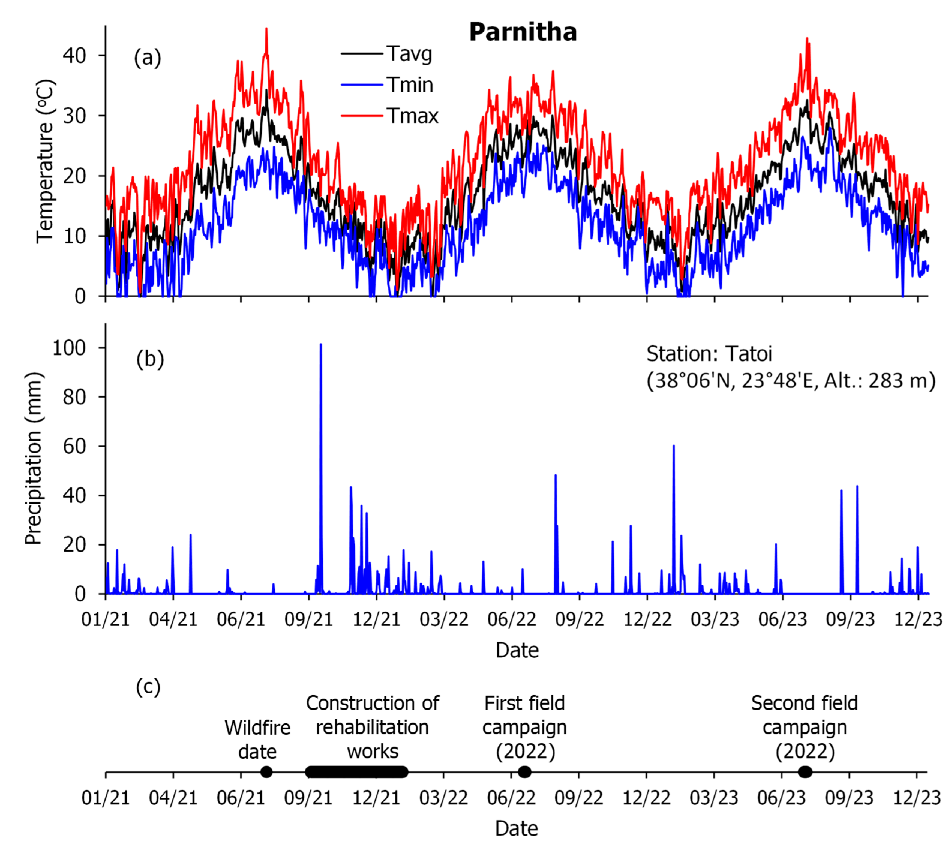
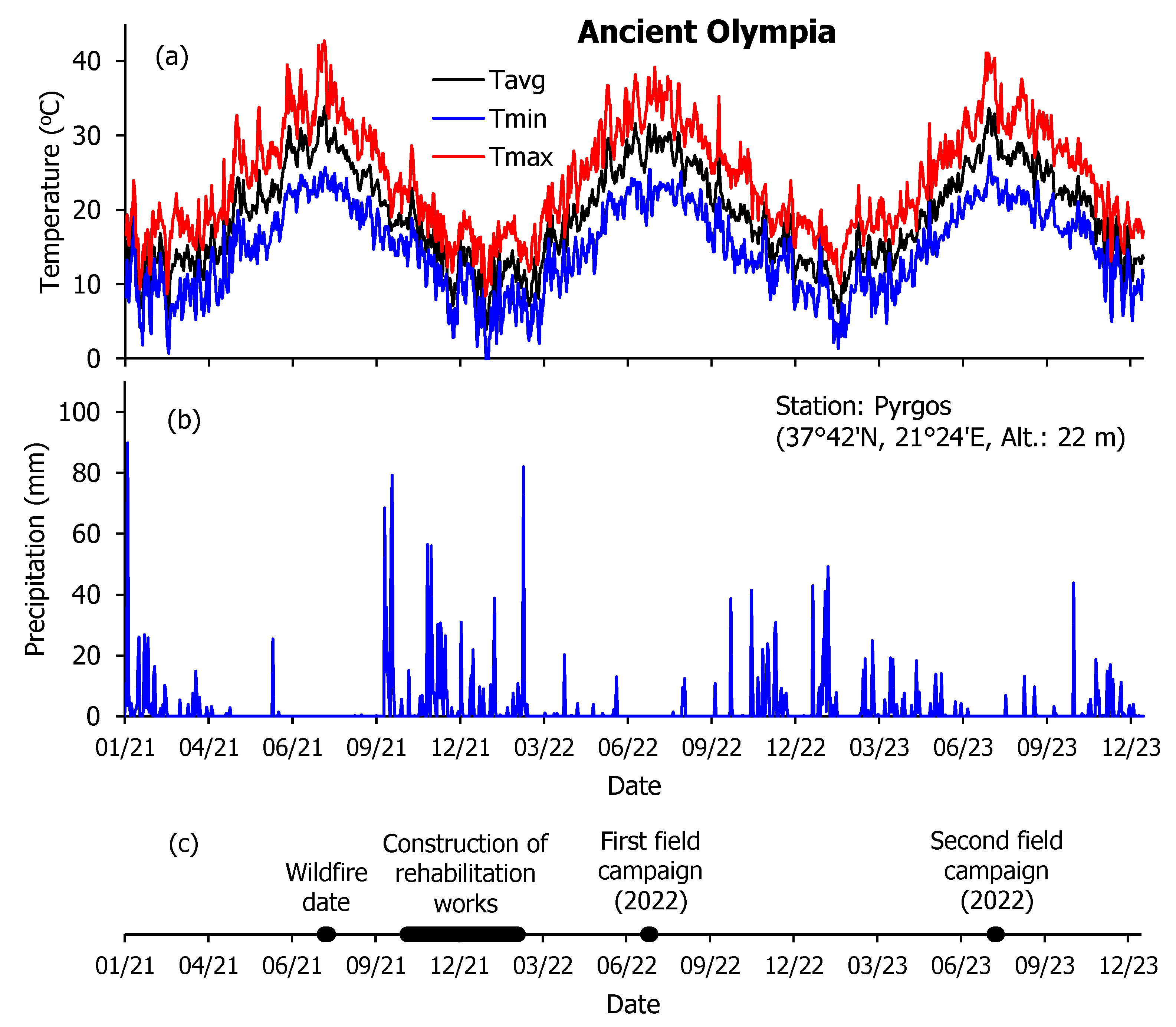
3.1. Meteorological Conditions After the Wildfires

Following wildfire, the meteorological conditions greatly influence the effectiveness of erosion control measures, the regrowth of vegetation, and the erosion of bare soil, thus affecting the soil’s ability to infiltrate precipitation water. In the post-fire years (2021–2023), the average annual temperature in Parnitha ranged from 16.4 °C in 2021 to 17.0 °C in 2023. During this period, maximum temperatures ranged between 22.0 °C in 2022 and 22.7 °C in 2023, while minimum temperatures increased from 10.9 °C in 2021 to 11.9 °C in 2023, as recorded by the nearby meteorological station of the National Observatory of Athens (NOA) in Tatoi (38°06′ N, 23°48′ E, Alt.: 283 m, [55]). The annual precipitation also varied and was almost double during the wildfire year in 2021 (626 mm) compared to 2022 (365 mm).
Daily temperatures and precipitation in the area are presented in Figure 7. Seasonally, we observed typical climatic variations with warmer temperatures and less precipitation during summer and the opposite in winter. Notably, the winter, summer, and autumn of 2023 and the spring of 2021 were warmer than other years. Meanwhile, the winter and autumn of 2022 (one year after the wildfire) and the spring and summer of 2021 received less precipitation. The greatest daily precipitation was 101.4 mm recorded on 14 October 2021, shortly after the fire, with other notable high-rainfall days spread over the subsequent years.
The average annual temperature in Mavrolimni, from 2021 to 2023, fluctuated between 19.4 °C in 2022 and 20.0 °C in 2023, according to the weather station of the NOA in Loutraki (38°00′ N, 23°00′ E, Alt.: 24 m), as depicted in Figure 8. The annual rainfall was higher in 2023 (388.4 mm), compared to 2022 (241.2 mm). The winter of 2021 and spring and summer of 2023 were particularly warm, while the corresponding rainfall was generally lower in the winter and autumn of 2022, as well as the spring and summer of 2021.
The post-fire meteorological conditions in Ancient Olympia showed slight variations in the average annual temperature for the years 2021–2023 around 19.2 °C (Figure 9), according to the weather station data of the NOA in Pyrgos (37°42′ N, 21°24′ E, Alt.: 22 m).
Rainfall showed more significant yearly variations, from 1145.0 mm in 2021 to 667.2 mm in 2022. The winter and spring of 2021, the summer of 2022, and the autumn of 2023 experienced warmer temperatures compared to other years, while less rainfall occurred in the winter of 2022, the spring and summer of 2021, and the autumn of 2023. The highest rainfall volumes were recorded in the winter (535 mm) and autumn (519 mm) of 2021, followed by the spring of 2023 (240 mm), and the summer of 2022 (33 mm).
The maximum daily rainfall over the three-year period was 89.8 mm, recorded on 4 January 2021, whereas other significant precipitation events included 82.0 mm on 5 March 2022; 79.2 mm on 15 October 2021; 68.4 mm on 10 July 2021; 59.0 mm on 14 October 2021; 56.4 mm on 22 November 2021; 56.0 mm on 26 November 2021; 49.2 mm on 26 January 2023; 43.8 mm on 17 October 2023; 42.8 mm on 1 October 2023; 41.4 mm on 5 November 2022; and 41.0 mm on 23 January 2023.
The above-mentioned patterns indicate that rainfall events occurred after the wildfire and before the construction of the rehabilitation. If the soil was hydrophobic after the wildfire, then the hydrophobic status of the soil was most likely removed by the rainfall. Soil hydrophobicity decreases as soil moisture increases [15].

3.2. Changes in Soil Properties and Vegetation Density

The soil moisture, measured at the deposition and the erosion zones during noon on a clear July day, was very low, regardless of the site, the year of measurement, or the type of rehabilitation work, indicating the extremely dry soil conditions prevailing at all study sites during the field campaigns, as clearly indicated in Table 2.
The soil sample analysis also indicates changes in the soil texture in the deposition zones, and, in some cases, even changes in the soil type were detected, attributed to the ongoing erosion process occurring post-fire. More specifically, from all soil samples analyzed (25 in the deposition and 25 in the erosion zones), changes in soil content in sand were detected to be higher at the deposition zones compared to the erosion zones. In contrast, the silt and clay content were lower, regardless of the type of rehabilitation structure. This was evident during both years of measurements. The results of the soil samples’ mechanical analysis for the two years of measurements (2022 and 2023) in the deposition and erosion zones are presented in Table 3. Such changes in soil texture to higher sand percentages highly affect the soil hydraulic characteristics, enhancing infiltration at the deposition zones.
The changes in vegetation density were also monitored at all plots. During the first year of measurements (2022), i.e., one year after the wildfires, the vegetation density was higher at the erosion zones regardless of the site or the type of construction. This pattern changed in the second year (2023), and the vegetation density was higher at the deposition zones. It should also be mentioned that vegetation density at the deposition zones increased its values in 2023 compared to 2022, whereas the opposite was recorded at the erosion zones at all sites, except for Ancient Olympia, where its values were almost constant. In all cases, however, the vegetation density average values have very high standard deviations, indicating highly variable vegetation patterns among the plots. The vegetation patterns suggest that vegetation density is constantly changing during the two years after the wildfire, and this is probably attributed to the changing soil properties, erosion phenomena, and also the harsh meteorological conditions with high temperature and limited soil water availability, especially during the warm period of the year as indicated in Figure 7, Figure 8 and Figure 9 and Table 2. The decrease in vegetation density in the erosion zone (EZ) in 2023 is probably affected by these conditions, resulting in the drying of vegetation, especially in the constantly eroding EZ. The average vegetation values for all plots per site, along with the standard deviations, are presented in Table 4.
Concerning the qualitative characteristics of the recovered vegetation, the species identification showed that the vegetation communities in all sites were generally dominated by native species. More specifically in Parnitha, the identified native species were 32, whereas no alien species were recorded. Similarly, in Mavrolimini, native species (15 species) dominated the area, and no alien ones were detected. In Ancient Olympia 23 native and 2 alien plant species were identified.

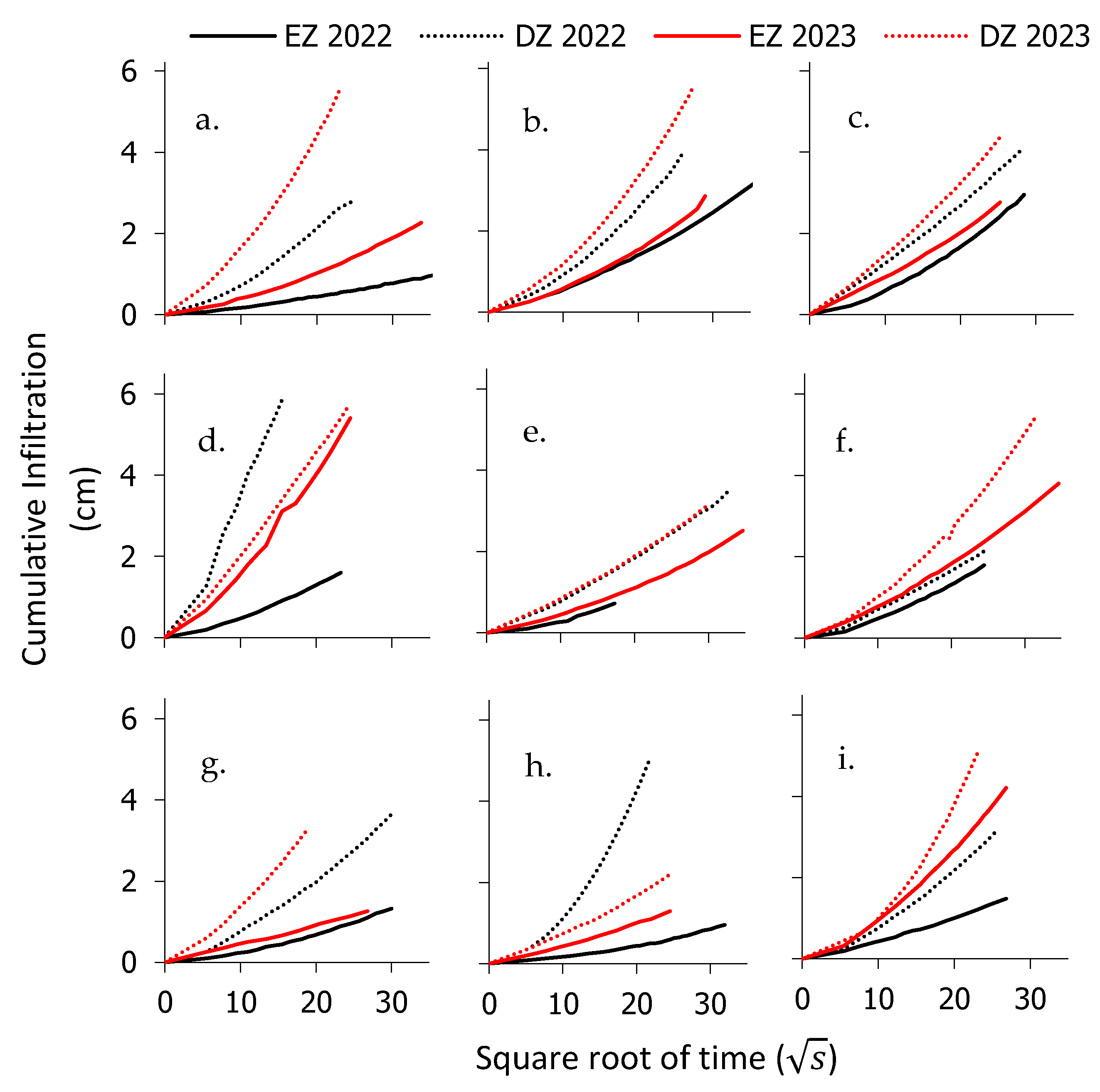
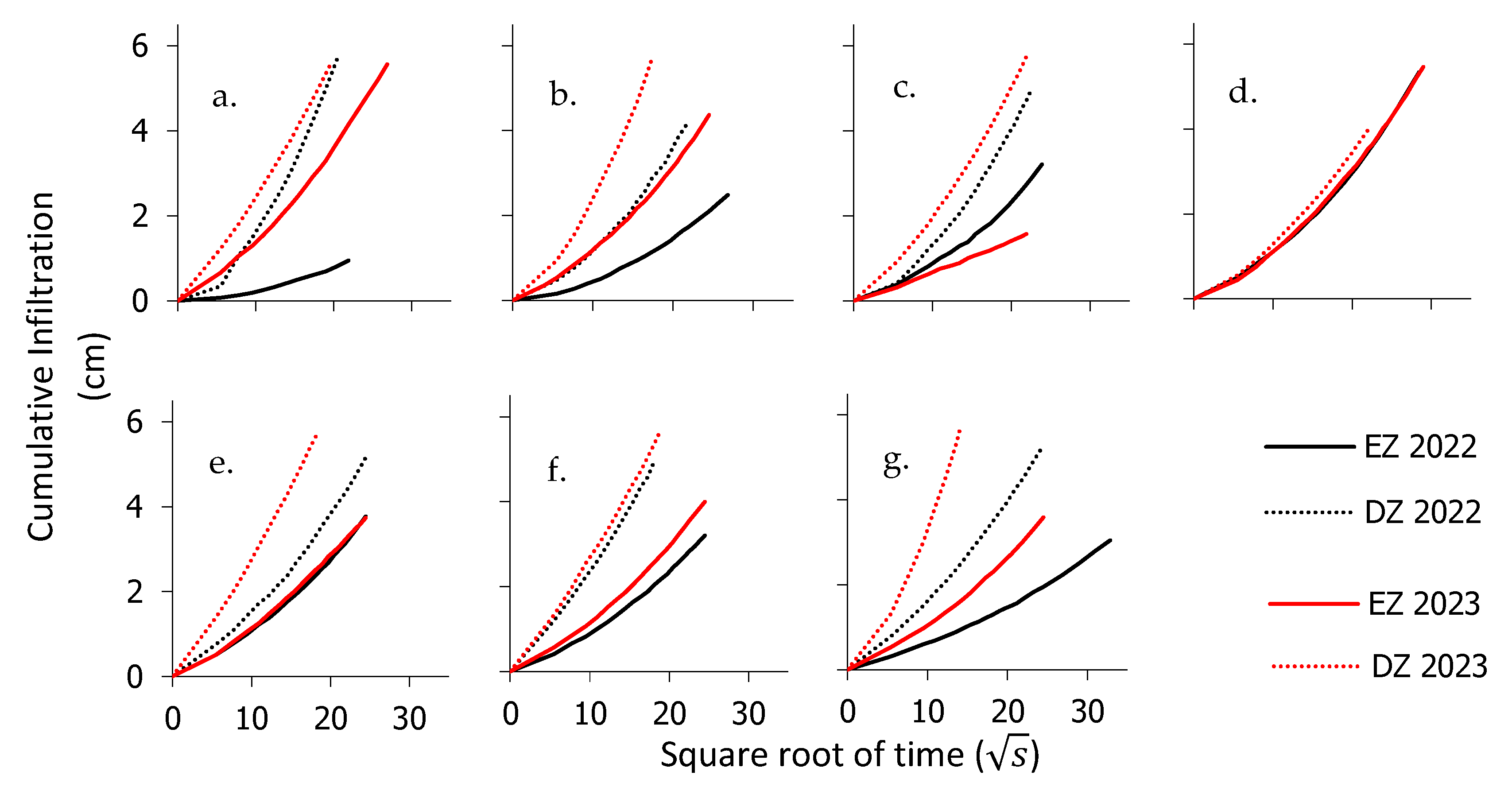
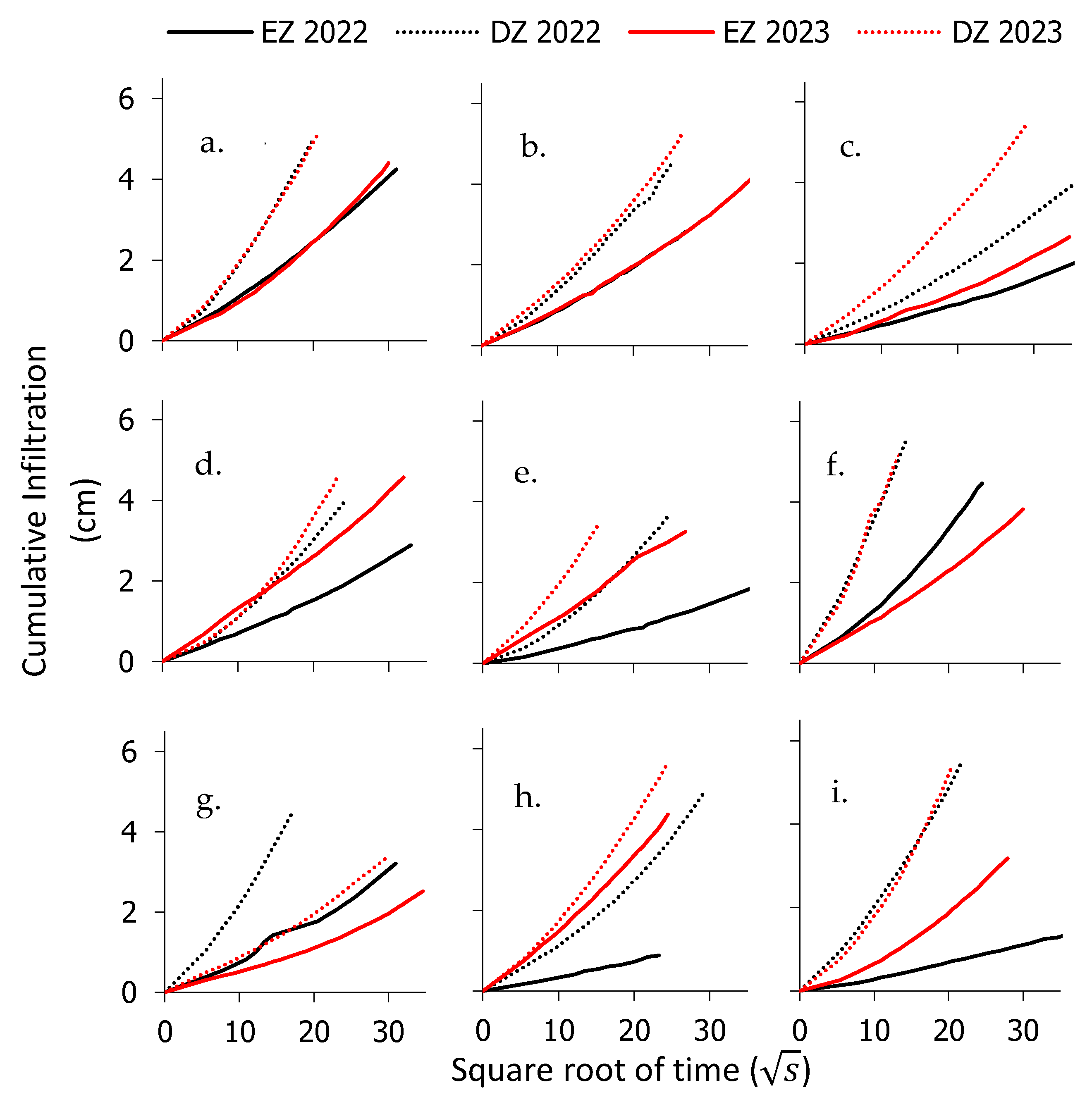
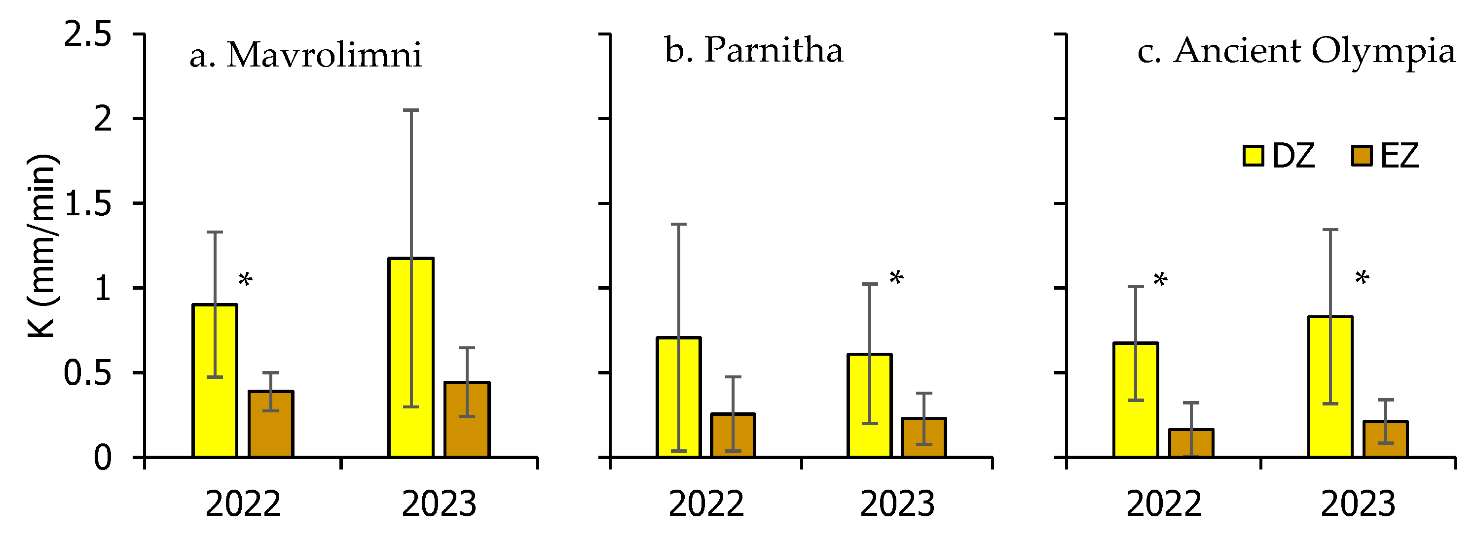
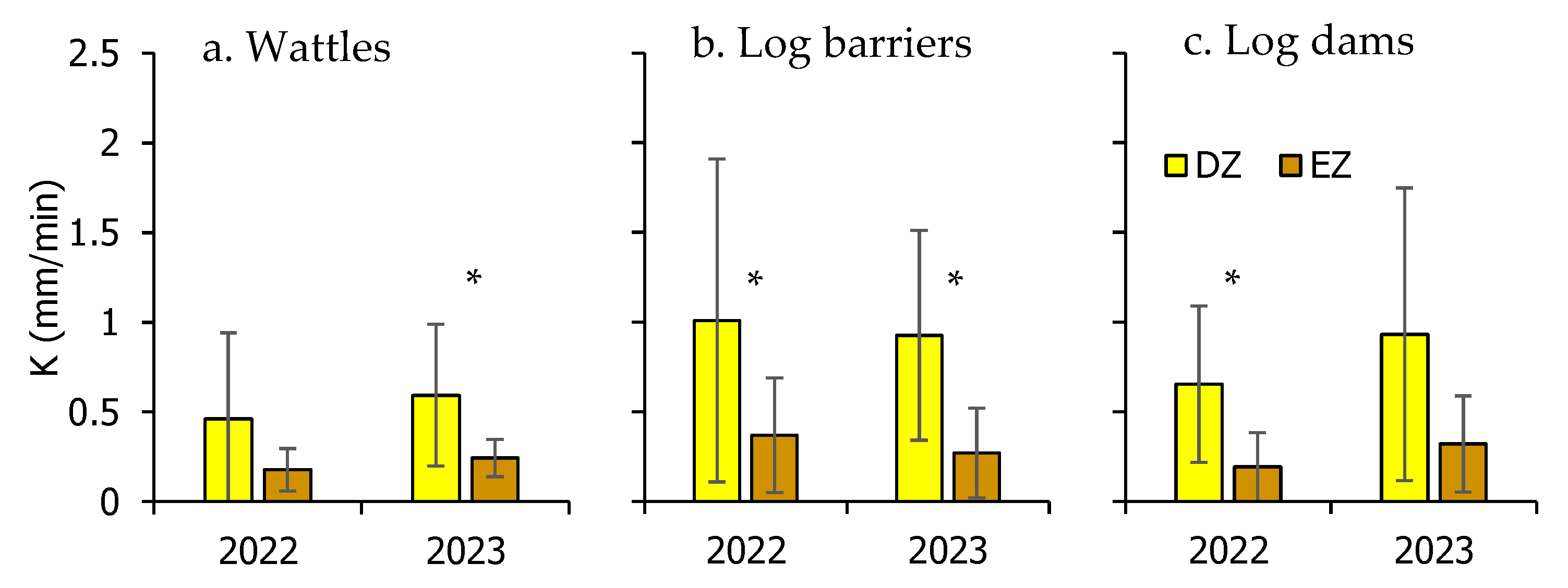
3.3. Changes in Infiltration Capacity and Soil Water Conductivity

In general, burned forest soils are characterized by decreased infiltration ability compared to unburned ones, enhancing surface runoff and risk for soil erosion. The installation of different types of rehabilitation works, immediately after the fires, appears to moderate the negative effects on the infiltration ability of the restored forest soils. In the 100 infiltration experiments conducted in this study (25 at the deposition and 25 at the erosion zones, during the first and the second year after restoration), the positive effect of restoration is identified. The values of the cumulative infiltration rates at the deposition (DZ) and erosion (EZ) zones of all experimental plots during the years 2022 and 2023 at all study sites are presented in Figure 10, Figure 11 and Figure 12.
Overall, significantly higher infiltration rates (paired t test: t = −7.1311, p < 0.001, n = 50) are measured at the deposition zones of all different types of rehabilitation works during both years of measurements, regardless of the rehabilitation type of the structure or study site, suggesting a positive effect, at least on a short-term basis (during the two post-fire years). This is critical, considering that, during this period, the impoverished soil, by wildfires, is highly vulnerable to soil erosion from water, and thus higher infiltration ability can prevent surface runoff.
Based on the results of the cumulative infiltration curves presented above, the respective values for the unsaturated hydraulic conductivity K were estimated, and their average values per study site are shown in Figure 13.
Over the course of the initial two-year period, the field experiments conducted on the 25 surfaces consistently revealed notable differences in K values at the deposition zones compared to the erosion zones. This trend, with much higher K values at the deposition zones, was observed across the diverse research sites, irrespective of the specific soil type. It should be mentioned, however, that significant differences in each site and for each year were identified in Mavrolimni during the year 2022 (t = −2.9393, p = 0.026, n = 7), in Parnitha in 2023 (t = −3.7606, p = 0.055, n = 9) and in Ancient Olympia for both the 2022 (t = −6.3657, p = 0.002, n = 9) and 2023 (t = −3.7099, p = 0.006, n = 9) years of measurements. In Mavrolimni during 2022 and in Parnitha during 2023, the differences in the K values between deposition and erosion remain positive, though not significant.
In general, the average unsaturated hydraulic conductivity K values at the deposition zones (DZ)—regardless of the structure type—ranged from 0.61 mm/min in Parnitha in 2023 to 1.17 mm/min in Mavrolimni in the same year, while, at the erosion zones (EZ), K varied between 0.16 mm min−1 in Ancient Olympia in 2022 and 0.44 mm/min in Mavrolimni in 2023.
At the site of Parnitha, K in DZ exhibited a significant increase compared to EZ, with a 177% disparity in 2022 and a slight decrease to 169% in 2023. This trend was also similar in Mavrolimni, where DZ displayed a 132% higher hydraulic conductivity than EZ in 2022, escalating to 165% in 2023. These observations point towards a general gradual improvement in the hydraulic behavior of the deposition zones over time, while the erosion zones showed relatively stable characteristics.
The most notable differences were observed in Ancient Olympia, where K was found to be about three times higher in DZ compared to EZ during both years of measurements. Such differences in the K values underscore the profound impact of erosion mitigation treatments on enhancing the soil’s hydraulic behavior, facilitating efficient water infiltration while mitigating the risk of erosion-induced runoff.
To investigate the hydraulic behavior of the different types of rehabilitation structures (wattles, log barriers, and log dams), the average K values at the zones DZ and EZ were assessed for the post-fire years of 2022 and 2023, as depicted in Figure 14.
At the wattles, the average hydraulic conductivity K was 159% higher in the DZ compared to the EZ in 2022, with a slight decrease to 145% in 2023. It is worth mentioning that the differences in K between DZ and EZ were positive in both years but significant only in 2023 (t = −4.6011, p = 0.058, n = 6). From 2022 to 2023, K increased in both zones (by 29% in DZ and 36% in EZ), suggesting that soil hydraulic properties are gradually restored after the wildfires.
The year-to-year changes in K at the log barriers were not appreciable. However, the difference between the two zones was large, with DZ showing an average K significantly greater by 174% in 2022 (t = −3.4435, p = 0.073, n = 10) and by 243% in 2023 (t = −3.6858, p = 0.050, n = 10), relative to EZ. Similarly, the log dams exhibited large differences between the two zones. DZ showed 240% higher values than zone EZ in 2022 (t = −2.5821, p = 0.032, n = 9), while the percentage remained high (190%), though not significant (t = −1.4469, p = 0.186, n = 9) in the following year. Both zones experienced a notable increase in soil permeability in 2023 relative to 2022, with a rise in K values of 42% at the DZ and 67% at the EZ.

4. Discussion

Our findings confirm the working hypothesis: deposition zones consistently exhibited significantly higher unsaturated hydraulic conductivity (K) compared to erosion zones, regardless of site or structure type. The extent of this improvement varied across structure types, supporting the expected structure-specific effectiveness.
The differences in infiltration ability noted across the deposition and erosion zones, especially with regard to log barriers and log dams, which were installed on medium-to-steep gradient terrains, show that the use of these structures is capable of augmenting infiltration. While the present study did not independently vary structure spacing or classify types of slope, the significant effectiveness of certain structures placed within gradients that are more steeply inclined (e.g., Ancient Olympia) highlights the importance of topographic conditions. Thus, it is reasonable to hypothesize that placing these structures more closely together in landscapes that are prone to steep erosion would further increase hydrological response. More directed study is necessary to assess optimal positioning strategy under various conditions of slope and soil type, with respect to the existing methodologies for the design and installation of post-fire rehabilitation works.
The construction of rehabilitation works through the application of post-fire hillslope stabilization techniques (either by the wattles, the log barriers, or the log dams) result in a zonation of the burnt areas. These works are considered nature-based solutions (NbSs) for combating accelerated erosion following wildfires. Their effectiveness extends beyond preventing soil loss to also supporting natural regeneration [24,56]. Ιt is noteworthy that, in some cases, they were fully covered with sediments, after a short period of intense rainfalls, avoiding sedimentation in the downstream plain infrastructures [57].
After installation, soil surface roughness increases, creating distinct zones near and between the rehabilitation structures. These zones exhibit different vegetation patterns [58], soil [59], and micrometeorological [50] properties. The rehabilitation work units act as a physical barrier, trapping the detached soil particles and seeds and generating higher soil moisture near the elements (logs or branches) of the structures, and may change the post-fire forest structure, vegetation composition [60], and the soil texture and properties including nutrient availability and water infiltration capacity [61]. The increase in hydraulic conductivity in the nearby structure zones is also confirmed in our study, where the unsaturated hydraulic conductivity exhibited values higher than 130% at the deposition zone near the structure compared to the erosion zone above the structure, regardless of the type of rehabilitation structure and the study site, being even three-fold higher at the site of Ancient Olympia. In addition, these differences were also sustained in the second year post-restoration. This aligns with the findings of Vieira et al. [62], who identified peak hydrological and erosive responses in burned Mediterranean forests in the second or third post-fire year, indicating a prolonged period of soil vulnerability.
Parental rock type generally affects the K values. In Mavrolimni, where peridotite–gabbros rocks dominate, K in 2022 averaged 1.06 mm/min in the deposition zone. In contrast, deposition cone soils, covering a smaller area, showed much lower K values (0.49 mm/min). At the erosion zone, K values were much lower (0.41 and 0.33 mm/min). In 2023, K increased in the deposition cones rock to 1.67 mm/min in the deposition zone and to 0.48 mm/min in the erosion zone. Meanwhile, values in the peridotite–gabbro parental areas remained almost stable (0.98 mm/min in the deposition zones and 0.43 mm/min in the erosion zones). This pattern can be partly attributed to the lower sand content of the soils formed above peridotite–gabbro parental rocks (51.0–59.5% regardless of the zone and year of measurement), compared to higher sand percentages in the deposition cones soils (59.8–72.0%).
The dominant schists in Parnitha showed relatively low ability to infiltrate water, with identical K values between the two years of measurements at the erosion zones (average 0.19 mm/min). At this zone, the percentage of sand during 2022 and 2023 remained constant (62.7% in 2022 and 62.9 in 2023), and the vegetation density (26 plants/m2 in 2022 and 22 plants/m2 in 2023) was also stable. However, at the deposition zone, the sand content decreased from 67.1% in 2022 to 61.6% in 2023 and probably affected the hydraulic conductivity, which presented a decrease from 0.86 mm/min in 2022 to 0.56 mm/ min in 2023, retaining, however, much higher K values compared to the deposition zones. It should be stated, though, that the relatively high increase in the vegetation density in the deposition zone (from 8 plants/m2 in 2022 to 39 plants/m2 in 2023) did not adversely affect the reduction in K, and this is probably attributed to the shallow rooted annual plant species, grown in the region.
The tertiary deposit rocks, dominating the Ancient Olympia’s site, also showed high sand percentages of the above to the parental rock soil at the erosion zones of the rehabilitation structures, ranging, on average, from 65.4% in 2022 to 63.9% in 2023. These small changes in the sand content, also followed by relatively small decreases in vegetation density (from 51 plants/m2 in 2022 to 37 plants/m2 in 2023), did not affect the K values, which were on average 0.22 mm/min in 2022 and 0.24 mm/min in 2023. However, the changes in K were more sound at the deposition zones and in 2022 had an average of 0.61 mm/min and increased to 0.80 mm/min in 2023. This increase is probably associated with the increase in soil’s sand content at the deposition zone from 66.1% in 2022 to 70.5% in 2023, and also by the increased vegetation density (from 29.7 plants/m2 in 2022 to 68.1 plants/m2 in 2023) with mainly perennial deep rooted plant species, enhancing the soils’ ability to infiltrate water.
The insufficient monitoring of restoration efforts is identified by other researchers [63]. In our work, the type of the rehabilitation structure also affects the effectiveness of the soil to infiltrate water. However, all rehabilitation types presented higher values of unsaturated hydraulic conductivity by 159% at the soil particles transported to the deposition zones compared to the erosion zones during the first post-rehabilitation year, but the log barriers and log dams had even better performance, and the respective percentages were even higher, exceeding 170%. In addition, the effectiveness of the structure units remained at similar magnitudes during the second post-rehabilitation year, suggesting a constant positive behavior or the rehabilitation constructions at least in the past two years after their installation.
Regardless of the rehabilitation structure type, vegetation dynamics were found to be highly variable in all sites in our study. This is probably associated with the constantly changing surface soil properties due to erosion and deposition processes. However, the vegetation is highly affecting the soil’s ability to infiltrate water and should be considered in hydrological assessments of burnt forest soils.
This study has specific limitations that should be acknowledged. Infiltration measurements were conducted during the dry summer months, primarily due to field accessibility and safety concerns in steep, post-fire terrain during the wet season. Moreover, since the wildfire occurred in summer, this study was designed to capture soil hydrological conditions one and two years post-fire and after the winter rainfalls. The use of mini-disk infiltrometers, which measure unsaturated hydraulic conductivity, is also influenced by antecedent soil moisture; therefore, seasonal comparisons would require either alternative instrumentation or moisture-correction protocols. Future research should consider year-round monitoring and experimental designs that systematically vary slope, structure type, and seasonal conditions to better capture the dynamics of soil hydrological recovery in burned landscapes.

5. Conclusions

The post-fire rehabilitation activities performed in the three studied Mediterranean sites of Greece (Parnitha-Attica, Mavrolimni-Corinth, and Ancient Olympia-Ilia) altered the burnt terrain, forming distinct zones and modifying the sites’ hydrologic and hydraulic behavior. Soil hydraulic properties exhibit noticeable differences between the deposition and the erosion zones, forming between consecutive structures of the different rehabilitation types of structures (log barriers, log dams, and wattles). Over two post-restoration years, field infiltration experiments demonstrated better hydrological performance in the deposition zones compared to the erosion zones. The higher unsaturated hydraulic conductivity K values at the deposition zones compared to the erosion zones were measured across all study areas during both years of observation. In Parnitha, K was 177% higher in the deposition zones than erosion zones in 2022 and 169% in 2023. The year-to-year changes in the two zones were minimal, showing consistent and high K values in 2022 and 2023. In Mavrolimni, K was on average 132% higher in deposition zones than in erosion zones in 2022 and increased to 165% in 2023, suggesting a slight improvement in soil hydraulic behavior of the deposition zones compared to the previous year, while the erosion zones remained largely unchanged. In Ancient Olympia, deposition zone hydraulic properties were drastically improved compared to erosion zones, with K being 311% higher in 2022 and maintaining a substantial positive difference (293%) in 2023. Overall, the values of unsaturated hydraulic conductivity in the deposition zones in 2023 ranged from 0.61 mm/min in Parnitha to 1.17 mm/min in Mavrolimni. In contrast, K in the erosion zones varied from 0.16 mm/min in Ancient Olympia in 2022 to 0.44 mm/min in Mavrolimni in 2023. The notable improvement in the capacity of Ancient Olympia’s soil to infiltrate water is especially significant and attributed to the formation of deposition zones from the construction of rehabilitation work units.
The type of rehabilitation structure (wattles, log barriers, or log dams) further affects the soil hydraulic behavior. For wattles, K was 159% higher in the deposition zone than in the erosion zone in 2022, with a similar percentage (145%) maintained in 2023. The deposition zone showed a 29% increase in K during 2023 compared to 2022, while the erosion zone presented a slightly higher increase (36%). At log barriers, the year-to-year variation in K was not substantial, but the disparity between the two zones was significant. In 2022, the mean K in the deposition zones was 174% greater than in the erosion zones, and their difference increased to 243% in 2023. Similarly, the log dam deposition zones demonstrated K values 240% higher than those of erosion in 2022, and this high difference was maintained the following year (190%). It is worth noting that both zones at the log dams showed a notable increase in soil infiltration rates, with K values in 2023 being higher by 42% at the deposition zones and 67% at the erosion zones, compared to 2022.
These results support the working hypothesis that erosion control structures enhance post-fire soil infiltration, especially in the deposition zones formed near the interventions. The observed structure-specific differences underscore the need for tailored restoration planning based on slope, soil type, and site conditions.
The results underline the significant positive effect of rehabilitation works on the hydraulic properties of burnt Mediterranean soils through the formation of zones in the soil surface that promote water infiltration at least during short periods after the wildfires. This effect appears to be consistent at least two years post-restoration. The soil parental rock of the burned sites, along with the vegetation development and its year-to-year changes, appear to be influential factors forming the burnt soils’ hydraulic behavior. Especially, the vegetation density appears to influence the burnt soils’ infiltration ability, being affected by the rehabilitation constructions. It should be noted, however, that, on a short-term basis (one and two years after the wildfire), the burnt soils have highly variable soil properties and changing vegetation coverage as a result of the on-going erosion process. Under such conditions the unstable soil has diverse hydraulic behavior, which is also affected by the presence of the rehabilitation structures. The need for continuous monitoring of the restored ecosystems and evaluation of the post-fire management is critical for the full recovery of the burnt forests, especially in the Mediterranean. Future research should continue to monitor and investigate the long-term effects of wildfires on soil hydraulic properties and develop innovative strategies to address the challenges posed by changing hydrological dynamics in fire-affected landscapes.

Author Contributions

Conceptualization, N.D.P. and S.P.S.; methodology, N.D.P., S.P.S. and A.B.; formal analysis, N.D.P., S.P.S., A.D.S., P.M. and A.B.; investigation, N.D.P., S.P.S., A.D.S., P.M. and A.B.; resources, N.D.P., S.P.S., A.D.S., P.M. and A.B.; data curation, N.D.P., S.P.S., A.D.S., P.M. and A.B.; writing—original draft preparation, N.D.P., S.P.S., A.D.S., P.M. and A.B.; writing—review and editing, N.D.P., S.P.S., A.D.S., P.M., A.B. and P.L.; supervision, N.D.P.; project administration, N.D.P.; funding acquisition, N.D.P. All authors have read and agreed to the published version of the manuscript.

Funding

This research was financially supported by the Hellenic Green Fund, grant number 21SYMV008996029 2021-07-28, with beneficiary the Directorate General for Forests and Forest Environment of the Hellenic Ministry of Environment and Energy. Research Project: MoRe Forests “MOnitoring the impact of REstoration works in the post fire Forest environment in Greece”.

Data Availability Statement

The data presented in this study are available upon request from the corresponding author.

Acknowledgments

The authors acknowledge the contribution of the personnel of the Directorate General for Forests and Forest Environment, especially the General Director Evangelos Goudoufas, Stavros Tsilikounas, Vereniki Louka, Eleni Giakoumi, Ourania Karabini, and Nikolaos Tzouras for the administrative support of this research project. The support from the personnel of the Forest Departments of Pyrgos and Corinth, and especially Panagiotis Kalliris and George Blanos are also highly acknowledged.

Conflicts of Interest

The authors declare no conflicts of interest.

References

  1. Inbar, M.; Tamir, M.I.; Wittenberg, L. Runoff and erosion processes after a forest fire in Mount Carmel, a Mediterranean area. Geomorphology 1998, 24, 17–33. [Google Scholar] [CrossRef]
  2. Úbeda, X.; Pereira, P.; Outeiro, L.; Martin, D. Effects of fire temperature on the physical and chemical characteristics of the ash from two plots of cork oak (Quercus suber). Land Degrad. Dev. 2009, 20, 589–608. [Google Scholar] [CrossRef]
  3. Wittenberg, L.; Malkinson, D.; Beeri, O.; Halutzy, A.; Tesler, N. Spatial and temporal patterns of vegetation recovery following sequences of forest fires in a Mediterranean landscape, Mt. Carmel Israel. Catena 2007, 71, 76–83. [Google Scholar] [CrossRef]
  4. Francos, M.; Úbeda, X.; Pereira, P. Impact of torrential rainfall and salvage logging on post-wildfire soil properties in NE Iberian Peninsula. Catena 2019, 177, 210–218. [Google Scholar] [CrossRef]
  5. Proutsos, N.D.; Tsiros, I.X.; Nastos, P.; Tsaousidis, A. A note on some uncertainties associated with Thornthwaite’s aridity index introduced by using different potential evapotranspiration methods. Atmos. Res. 2021, 260, 105727. [Google Scholar] [CrossRef]
  6. Tsiros, I.X.; Nastos, P.; Proutsos, N.D.; Tsaousidis, A. Variability of the aridity index and related drought parameters in Greece using climatological data over the last century (1900–1997). Atmos. Res. 2020, 240, 104914. [Google Scholar] [CrossRef]
  7. Stefanidis, S.; Rossiou, D.; Proutsos, N. Drought severity and trends in a Mediterranean oak forest. Hydrology 2023, 10, 167. [Google Scholar] [CrossRef]
  8. Dimitrakopoulos, A.; Gogi, C.; Stamatelos, G.; Mitsopoulos, I. Statistical analysis of the fire environment of large forest fires (> 1000 ha) in Greece. Pol. J. Environ. Stud. 2011, 20, 327–332. [Google Scholar]
  9. Fernandez-Anez, N.; Krasovskiy, A.; Müller, M.; Vacik, H.; Baetens, J.; Hukić, E.; Kapovic Solomun, M.; Atanassova, I.; Glushkova, M.; Bogunović, I. Current wildland fire patterns and challenges in Europe: A synthesis of national perspectives. Air Soil Water Res. 2021, 14, 11786221211028185. [Google Scholar] [CrossRef]
  10. FAO; Plan Bleu. State of Mediterranean Forests 2018; Food and Agriculture Organization of the United Nations, United Nations Environment Programme, Mediterranean Action Plan Barcelona Convention, Plan Bleu: Rome, Italy; Marseille, France, 2018. [Google Scholar]
  11. Morán-Ordóñez, A.; Duane, A.; Gil-Tena, A.; De Cáceres, M.; Aquilué, N.; Guerra, C.A.; Geijzendorffer, I.R.; Fortin, M.J.; Brotons, L. Future impact of climate extremes in the Mediterranean: Soil erosion projections when fire and extreme rainfall meet. Land Degrad. Dev. 2020, 31, 3040–3054. [Google Scholar] [CrossRef]
  12. McGuire, L.A.; Youberg, A.M. Impacts of successive wildfire on soil hydraulic properties: Implications for debris flow hazards and system resilience. Earth Surf. Process. Landf. 2019, 44, 2236–2250. [Google Scholar] [CrossRef]
  13. Shakesby, R.A. Post-wildfire soil erosion in the Mediterranean: Review and future research directions. Earth-Sci. Rev. 2011, 105, 71–100. [Google Scholar] [CrossRef]
  14. Soulis, K.X.; Generali, K.A.; Papadaki, C.; Theodoropoulos, C.; Psomiadis, E. Hydrological response of natural mediterranean watersheds to forest fires. Hydrology 2021, 8, 15. [Google Scholar] [CrossRef]
  15. Doerr, S.H.; Thomas, A.D. The role of soil moisture in controlling water repellency: New evidence from forest soils in Portugal. J. Hydrol. 2000, 231, 134–147. [Google Scholar] [CrossRef]
  16. Jordán, A.; Zavala, L.M.; Mataix-Solera, J.; Doerr, S.H. Soil water repellency: Origin, assessment and geomorphological consequences. Catena 2013, 108, 1–5. [Google Scholar] [CrossRef]
  17. Francos, M.; Colino-Prieto, F.; Sánchez-García, C. How Mediterranean Ecosystem Deals with Wildfire Impact on Soil Ecosystem Services and Functions: A Review. Land 2024, 13, 407. [Google Scholar] [CrossRef]
  18. Pereira, P.; Francos, M.; Brevik, E.C.; Ubeda, X.; Bogunovic, I. Post-fire soil management. Curr. Opin. Environ. Sci. Health 2018, 5, 26–32. [Google Scholar] [CrossRef]
  19. Carmona-Yáñez, M.D.; Francos, M.; Miralles, I.; Soria, R.; Ahangarkolaee, S.S.; Vafaie, E.; Zema, D.A.; Lucas-Borja, M.E. Short-term impacts of wildfire and post-fire mulching on ecosystem multifunctionality in a semi-arid pine forest. For. Ecol. Manag. 2023, 541, 121000. [Google Scholar] [CrossRef]
  20. Francos, M.; Pereira, P.; Alcañiz, M.; Úbeda, X. Post-wildfire management effects on short-term evolution of soil properties (Catalonia, Spain, SW-Europe). Sci. Total Environ. 2018, 633, 285–292. [Google Scholar] [CrossRef]
  21. Lucas-Borja, M.E.; Plaza-Álvarez, P.A.; Yáñez, M.D.C.; Miralles, I.; Ortega, R.; Soria, R.; Candel-Pérez, D.; Zema, D.A. Long-term evaluation of soil functionality in Mediterranean forests after a wildfire and post-fire hillslope stabilisation. For. Ecol. Manag. 2024, 555, 121715. [Google Scholar] [CrossRef]
  22. Robichaud, P.R.; Ashmun, L.E. Tools to aid post-wildfire assessment and erosion-mitigation treatment decisions. Int. J. Wildland Fire 2012, 22, 95–105. [Google Scholar] [CrossRef]
  23. Robichaud, P.R.; Wagenbrenner, J.W.; Pierson, F.B.; Spaeth, K.E.; Ashmun, L.E.; Moffet, C.A. Infiltration and interrill erosion rates after a wildfire in western Montana, USA. Catena 2016, 142, 77–88. [Google Scholar] [CrossRef]
  24. Sapountzis, M.; Efthimiou, G.; Stefanidis, P. The contribution of agrotechnical works following a fire to the protection of forest soils and the regeneration of natural forest. In Eco-and Ground Bio-Engineering: The Use of Vegetation to Improve Slope Stability, Proceedings of the First International Conference on Eco-Engineering, Thessaloniki, Greece, 13–17 September 2004; Developments in Plant and Soil Sciences; Springer: Dordrecht, The Netherlands, 2007; pp. 353–359. [Google Scholar]
  25. Lucas-Borja, M.E.; Fernández, C.; Plaza-Alvarez, P.A.; Zema, D.A. Variability of hydraulic conductivity and water repellency of soils with fire severity in pine forests and reforested areas under Mediterranean conditions. Ecohydrology 2022, 15, e2472. [Google Scholar] [CrossRef]
  26. Martin, D.A.; Moody, J.A. Comparison of soil infiltration rates in burned and unburned mountainous watersheds. Hydrol. Process. 2001, 15, 2893–2903. [Google Scholar] [CrossRef]
  27. Valzano, F.; Greene, R.; Murphy, B. Direct effects of stubble burning on soil hydraulic and physical properties in a direct drill tillage system. Soil Tillage Res. 1997, 42, 209–219. [Google Scholar] [CrossRef]
  28. Cerdà, A. Changes in overland flow and infiltration after a rangeland fire in a Mediterranean scrubland. Hydrol. Process. 1998, 12, 1031–1042. [Google Scholar] [CrossRef]
  29. Garrido-Ruiz, C.; Sandoval, M.; Stolpe, N.; Sanchez-Hernandez, J.C. Fire impacts on soil and post fire emergency stabilization treatments in Mediterranean-climate regions. Chil. J. Agric. Res. 2022, 82, 335–347. [Google Scholar] [CrossRef]
  30. Kribeche, H.; Bautista, S.; Gimeno, T.; Blade, C.; Vallejo, V.R. Evaluating the effectiveness of post fire emergency rehabilitation treatments on soil degradation and erosion control in semi-arid mediterranean areas of the Spanish South East. Arid Land Res. Manag. 2013, 27, 361–376. [Google Scholar] [CrossRef]
  31. Larson-Nash, S.S.; Robichaud, P.R.; Pierson, F.B.; Moffet, C.A.; Williams, C.J.; Spaeth, K.E.; Brown, R.E.; Lewis, S.A. Recovery of small-scale infiltration and erosion after wildfires. J. Hydrol. Hydromech. 2018, 66, 261–270. [Google Scholar] [CrossRef]
  32. Moody, J.A.; Ebel, B.A.; Nyman, P.; Martin, D.A.; Stoof, C.; McKinley, R. Relations between soil hydraulic properties and burn severity. Int. J. Wildland Fire 2015, 25, 279–293. [Google Scholar] [CrossRef]
  33. Moody, J.A.; Kinner, D.A.; Úbeda, X. Linking hydraulic properties of fire-affected soils to infiltration and water repellency. J. Hydrol. 2009, 379, 291–303. [Google Scholar] [CrossRef]
  34. Robichaud, P.R. Measurement of post-fire hillslope erosion to evaluate and model rehabilitation treatment effectiveness and recovery. Int. J. Wildland Fire 2005, 14, 475–485. [Google Scholar] [CrossRef]
  35. Kennard, D.; Gholz, H. Effects of high-and low-intensity fires on soil properties and plant growth in a Bolivian dry forest. Plant Soil 2001, 234, 119–129. [Google Scholar] [CrossRef]
  36. Robichaud, P.R. Fire effects on infiltration rates after prescribed fire in Northern Rocky Mountain forests, USA. J. Hydrol. 2000, 231, 220–229. [Google Scholar] [CrossRef]
  37. Savadogo, P.; Sawadogo, L.; Tiveau, D. Effects of grazing intensity and prescribed fire on soil physical and hydrological properties and pasture yield in the savanna woodlands of Burkina Faso. Agric. Ecosyst. Environ. 2007, 118, 80–92. [Google Scholar] [CrossRef]
  38. Dilshan, W.; Hiraga, Y.; Kazama, S. Effects of Large Wildfire Burned Scars on Downstream Flood Discharge in California Watersheds: A Hydrological Modeling Study. In Proceedings of the World Environmental and Water Resources Congress 2025, Anchorage, Alaska, 18–21 May 2025; pp. 20–28. [Google Scholar]
  39. González-Pelayo, O.; Andreu, V.; Gimeno-García, E.; Campo, J.; Rubio, J.L. Effects of fire and vegetation cover on hydrological characteristics of a Mediterranean shrubland soil. Hydrol. Process. Int. J. 2010, 24, 1504–1513. [Google Scholar] [CrossRef]
  40. Sion, B.; Samburova, V.; Berli, M.; Baish, C.; Bustarde, J.; Houseman, S. Assessment of the effects of the 2021 Caldor megafire on soil physical properties, eastern Sierra Nevada, USA. Fire 2023, 6, 66. [Google Scholar] [CrossRef]
  41. Oswald, B.P.; Dunson, C.P.; Farrish, K.W. Prescribed Burning under Differing Forest Cover Types and Its Influence on Soil Water Infiltration Rates and Physical Properties in East Texas Forests. Forests 2023, 14, 2083. [Google Scholar] [CrossRef]
  42. Inbar, A.; Lado, M.; Sternberg, M.; Tenau, H.; Ben-Hur, M. Forest fire effects on soil chemical and physicochemical properties, infiltration, runoff, and erosion in a semiarid Mediterranean region. Geoderma 2014, 221, 131–138. [Google Scholar] [CrossRef]
  43. Niemeyer, R.J.; Bladon, K.D.; Woodsmith, R.D. Long-term hydrologic recovery after wildfire and post-fire forest management in the interior Pacific Northwest. Hydrol. Process. 2020, 34, 1182–1197. [Google Scholar] [CrossRef]
  44. Zema, D.A. Postfire management impacts on soil hydrology. Curr. Opin. Environ. Sci. Health 2021, 21, 100252. [Google Scholar] [CrossRef]
  45. Lucas-Borja, M.E.; Zema, D.A.; Carrà, B.G.; Cerdà, A.; Plaza-Alvarez, P.A.; Cózar, J.S.; Gonzalez-Romero, J.; Moya, D.; de las Heras, J. Short-term changes in infiltration between straw mulched and non-mulched soils after wildfire in Mediterranean forest ecosystems. Ecol. Eng. 2018, 122, 27–31. [Google Scholar] [CrossRef]
  46. Mataix-Solera, J.; Guerrero, C. Efectos de los incendios forestales en las propiedades edáficas. In Incendios Forestales, Suelos y Erosión Hídrica; Universidad Miguel Hernández: Alicante, Spain, 2007; pp. 5–40. [Google Scholar]
  47. Hidayat, Y.; Purwakusuma, W.; Wahjunie, E.D.; Baskoro, D.P.T.; Rachman, L.M.; Yusuf, S.M.; Adawiyah, R.M.; Syaepudin, I.; Siregar, M.M.R.; Isnaini, D.A. Characteristics of soil hydraulic conductivity in natural forest, agricultural land, and green open space area. J. Pengelolaan Sumberd. Alam Lingkung. (J. Nat. Resour. Environ. Manag.) 2022, 12, 352–362. [Google Scholar] [CrossRef]
  48. Gadi, V.K.; Tang, Y.-R.; Das, A.; Monga, C.; Garg, A.; Berretta, C.; Sahoo, L. Spatial and temporal variation of hydraulic conductivity and vegetation growth in green infrastructures using infiltrometer and visual technique. Catena 2017, 155, 20–29. [Google Scholar] [CrossRef]
  49. Ghestem, M.; Sidle, R.C.; Stokes, A. The influence of plant root systems on subsurface flow: Implications for slope stability. Bioscience 2011, 61, 869–879. [Google Scholar] [CrossRef]
  50. Proutsos, N.D.; Solomou, A.D.; Michopoulos, P.; Bourletsikas, A.; Tsilikounas, S.; Louka, V.; Lattas, P.; Kalliris, P. Soil Optical and Hydraulic Properties of Burnt Forest Areas in Greece after the Implementation of Postfire Restoration Works–Preliminary Results. Environ. Sci. Proc. 2023, 26, 27. [Google Scholar] [CrossRef]
  51. NOFFi. National Observatory of Forest Fires (NOFFi). Available online: http://epadap.web.auth.gr (accessed on 21 May 2024).
  52. Zhang, R. Determination of soil sorptivity and hydraulic conductivity from the disk infiltrometer. Soil Sci. Soc. Am. J. 1997, 61, 1024–1030. [Google Scholar] [CrossRef]
  53. Proutsos, N.D.; Solomou, A.D.; Petropoulou, M.; Chatzipavlis, N.E. Micrometeorological and hydraulic properties of an urban green space on a warm summer day in a Mediterranean City (Attica–Greece). Land 2022, 11, 2042. [Google Scholar] [CrossRef]
  54. Bouyoucos, G.J. A recalibration of the hydrometer method for making mechanical analysis of soils. Agron. J. 1951, 43, 434–438. [Google Scholar] [CrossRef]
  55. NOA. Meteorological Data from Ground Stations in Greece. Available online: www.meteo.gr (accessed on 21 May 2024).
  56. Myronidis, D.I.; Emmanouloudis, D.A.; Mitsopoulos, I.A.; Riggos, E.E. Soil erosion potential after fire and rehabilitation treatments in Greece. Environ. Model. Assess. 2010, 15, 239–250. [Google Scholar] [CrossRef]
  57. Stefanidis, P.; Sapountzis, M.; Tziaftani, F.; Stefanidis, S. Torrent control works at the region of Peloponnese (Greece) after forest fire of 2007. In Challenges: Sustainable Land Management—Climate Change; Zlatic, M., Kostadinov, S., Eds.; Catena Verlag: Stuttgart, Germany, 2012; pp. 148–155. [Google Scholar]
  58. Solomou, A.; Proutsos, N.; Michopoulos, P.; Bourletsikas, A.; Tsilikounas, S.; Louka, V.; Lattas, P.; Kalliris, P.; Blanos, G. Short-term vascular plant biodiversity assessment in burned and restored forest areas of Greece. In Proceedings of the 3rd Mediterranean Geosciences Union Annual Meeting MedGU 2023, Ιstanbul, Türkiye, 26–30 November 2023. [Google Scholar]
  59. Michopoulos, P.; Proutsos, N.; Solomou, A.; Bourletsikas, A.; Tsilikounas, S.; Louka, V.; Lattas, P.; Kalliris, P.; Blanos, G. Effects of restoration works on soil properties of burned forest areas. In Proceedings of the 3rd Mediterranean Geosciences Union Annual Meeting MedGU 2023, Istanbul, Türkiye, 26–30 November 2023. [Google Scholar]
  60. Rago, M.M.; Urretavizcaya, M.F.; Lederer, N.S.; Defossé, G.E. Plant community response to forest fuel management in Patagonian pine plantations. Front. For. Glob. Change 2020, 3, 55. [Google Scholar] [CrossRef]
  61. Lucas-Borja, M.E.; Delgado-Baquerizo, M.; Muñoz-Rojas, M.; Plaza-Álvarez, P.A.; Gómez-Sanchez, M.E.; González-Romero, J.; Peña-Molina, E.; Moya, D.; de las Heras, J. Changes in ecosystem properties after post-fire management strategies in wildfire-affected Mediterranean forests. J. Appl. Ecol. 2021, 58, 836–846. [Google Scholar] [CrossRef]
  62. Vieira, D.; Malvar, M.; Martins, M.; Serpa, D.; Keizer, J. Key factors controlling the post-fire hydrological and erosive response at micro-plot scale in a recently burned Mediterranean forest. Geomorphology 2018, 319, 161–173. [Google Scholar] [CrossRef]
  63. Robichaud, P.R.; Beyers, J.L.; Neary, D.G. Evaluating the Effectiveness of Postfire Rehabilitation Treatments; US Department of Agriculture, Forest Service, Rocky Mountain Research Station: Fort Collins, CO, USA, 2000. [Google Scholar]
Figure 1. Locations of the study sites.
Fire 08 00269 g001
Figure 2. General aspect from the burned forest area in Parnitha in 2022.
Fire 08 00269 g002
Figure 3. General aspect of the burned forest area in Mavrolimni in 2022.
Fire 08 00269 g003
Figure 4. General aspect of the burned forest area in Ancient Olympia in 2022.
Fire 08 00269 g004
Figure 5. Different types of erosion control structures: (a) log barriers, (b) log dams, and (c) wattles.
Fire 08 00269 g005
Figure 6. Formation of deposition zoned (DZ), where the soil sediment accumulated at the study site of Ancient Olympia.
Fire 08 00269 g006
Figure 7. (a) Air average, minimum and maximum temperatures, and (b) precipitation in the broader area of Parnitha during the wildfire year of 2021 and the post-fire years of 2022 and 2023, according to the data of the meteorological station of the National Observatory of Athens in Tatoi [55]. The dates of the wildfires, the construction of rehabilitation work periods, and the field campaigns for the measurements are also depicted (c).
Fire 08 00269 g007
Figure 8. (a) Air average, minimum and maximum temperatures, and (b) precipitation in the broader area of Mavrolimni during the wildfire year of 2021 and the post-fire years of 2022 and 2023, according to the data of the meteorological station of the National Observatory of Athens in Loutraki [55]. The dates of the wildfires, the construction of rehabilitation work periods, and the field campaigns for the measurements are also depicted (c).
Fire 08 00269 g008
Figure 9. (a) Air average, minimum and maximum temperatures, and (b) precipitation in the broader area of Ancient Olympia during the wildfire year of 2021 and the post-fire years of 2022 and 2023, according to the data of the meteorological station of the National Observatory of Athens in Pyrgos [55]. The dates of the wildfires, the construction of rehabilitation work periods, and the field campaigns for the measurements are also depicted (c).
Fire 08 00269 g009
Figure 10. Cumulative infiltration curves at the eroded (EZ) and the deposition (DZ) zones, defined between two consecutive units of wattles (ac) log barriers (df) or log dams (gi) at the nine experimental plots of the study area in Parnitha, during the first (2022) and the second (2023) year from the construction of the works.
Fire 08 00269 g010
Figure 11. Cumulative infiltration curves at the eroded (EZ) and the deposition (DZ) zones, defined between two consecutive units of log barriers (ad) or log dams (eg) at the seven experimental plots of the study area in Mavrolimni, during the first (2022) and the second (2023) year from the construction of the works.
Fire 08 00269 g011
Figure 12. Cumulative infiltration curves at the eroded (EZ) and the deposition (DZ) zones, defined between two consecutive units of wattles (ac), log barriers (df), or log dams (gi) at the nine experimental plots of the study area in Ancient Olympia, during the first (2022) and the second (2023) year from the construction of the works.
Fire 08 00269 g012
Figure 13. Average values and standard deviations (vertical lines) of the unsaturated hydraulic conductivity K at the eroded (EZ) and the deposition (DZ) zones, defined between two consecutive units of rehabilitation work types at the experimental plots of (a) Mavrolimni, (b) Parnitha, and (c) Ancient Olympia, during the first (2022) and the second (2023) year from the construction of the works. The averages and standard deviations are estimated regardless of the type of rehabilitation structure. An asterisk (*) denotes the significant difference between DZ and EZ.
Fire 08 00269 g013
Figure 14. Average values and standard deviations of the unsaturated hydraulic conductivity at the eroded (EZ) and the deposition (DZ) zones, defined between two consecutive units of (a) wattles, (b) log barriers, and (c) log dams at all experimental plots, during the first (2022) and the second (2023) from the construction of the works. An asterisk (*) denotes the significant difference between DZ and EZ.
Fire 08 00269 g014
Table 1. Geographical, topographic, and geological characteristics of the study plots and types of rehabilitation structures for all study areas.
SitePlotLongitudeLatitudeAltitudeSlopeAspectStructure
Type
Parental
Rock
(deg.)(min)(deg.)(min)(m)(deg.)(deg.)
ParnithaP012347.6103810.88869413310wattleSchists
P022347.5973810.88568818325wattleSchists
P032347.5463810.94767219140log damSchists
P042347.5503810.93766523150log damSchists
P052347.5693810.50362110270log barrierSchists
P062347.4903810.0086052340log barrierTertiary deposits
P072347.4503810.0146082948log barrierTertiary deposits
P082347.4453810.02460312110log damTertiary deposits
P092347.5743810.92773429245wattleSchists
MavrolimniΜ01236.013383.21322428260log barrierPeridotites–gabbros
Μ02236.009383.22021930290log barrierPeridotites–gabbros
Μ03236.013383.22220518280log damPeridotites–gabbros
M04236.011383.23720528270log barrierPeridotites–gabbros
Μ05236.000383.23620022330log damDeposition cones
Μ06235.993383.25320017320log damDeposition cones
Μ07235.988383.26721618280log barrierPeridotites–gabbros
Ancient OlympiaAO012141.4713742.32570938234log barrierTertiary deposits
AO022141.5233742.30371934253log barrierTertiary deposits
AO032141.4803742.32170337195log barrierTertiary deposits
AO042141.4793742.29471215200wattleTertiary deposits
AO052141.4763742.29271215198wattleTertiary deposits
AO062141.4773742.29070913198wattleTertiary deposits
AO072141.4633742.32271726190log damTertiary deposits
AO082141.4613742.31872039174log damTertiary deposits
AO092141.4713742.32572125170log damTertiary deposits
Table 2. Changes in soil type and values of the per-volume soil moisture are measured at the soil erosion and deposition zones at the three study sites. Standard deviations (sd) of the values are also presented, estimated by the number of samples.
Study SiteZoneSoil Type (Number of Samples)Soil Moisture ± sd
(% p.v.)
2022202320222023
ParnithaDeposition Zone
(DZ)
Sandy Loam (7)
Loam (1)
Loamy Sand (1)
Sandy Loam (8)
Loam (1)
11.7 ± 10.14.1 ± 1.9
Erosion Zone
(EZ)
Sandy Loam (7)
Sandy Clay Loam (2)
Sandy Loam (7)
Loam (1)
Loamy Sand (1)
8.0 ± 7.65.2 ± 2.7
MavrolimniDeposition Zone
(DZ)
Sandy Loam (4)
Sandy Clay Loam (3)
Sandy Loam (4)
Sandy Clay Loam (2)
Loam (1)
4.6 ± 3.64.3 ± 0.8
Erosion Zone
(EZ)
Sandy Clay Loam (3)
Sandy Loam (3)
Loam (1)
Sandy Clay Loam (3)
Sandy Loam (3)
Loamy Sand (1)
4.2 ± 3.34.3 ± 2.0
Ancient OlympiaDeposition Zone
(DZ)
Sandy Loam (9)Sandy Loam (9)2.5 ± 3.01.8 ± 1.2
Erosion Zone
(EZ)
Sandy Loam (9)Sandy Loam (8)
Sandy Clay Loam (1)
0.8 ± 1.02.1 ± 1.2
Table 3. Average percentages (±standard deviations, sd) of sand, clay, and silt content of the samples at the deposition and erosion zones during the years 2022 and 2023 at the three study sites.
Site Soil Particle
Class
Average Percentages % ± sd
Deposition Zone (DZ) Erosion Zone (EZ)
Year 2022 Year 2023 Year 2022 Year 2023
ParnithaSand62.9 ± 9.163.9 ± 8.261.2 ± 6.762.6 ± 10.9
Clay13.3 ± 3.010.9 ± 4.614.8 ± 5.712.3 ± 4.4
Silt23.8 ± 7.225.1 ± 4.124.1 ± 4.425.1 ± 8.3
MavrolimniSand 60.6 ± 10.958.8 ± 14.253.6 ± 8.358.9 ± 11.4
Clay16.1 ± 8.218.2 ± 11.222.7 ± 7.218.5 ± 9.2
Silt23.4 ± 5.423.0 ± 5.823.7 ± 3.122.6 ± 6.7
Ancient OlympiaSand 69.9 ± 4.471.1 ± 6.967.9 ± 6.264.5 ± 3.0
Clay11.0 ± 2.09.6 ± 2.614.1 ± 1.514.4 ± 3.7
Silt19.1 ± 3.519.3 ± 4.818.0 ± 6.321.1 ± 2.1
Table 4. Average values (± standard deviations, sd) of vegetation density (plants/m2) measured at the soil deposition and erosion zones at the three study sites.
SiteVegetation Density (plants/m2) ± sd
Deposition Zone (DZ)Erosion Zone (EZ)
Year 2022Year 2023Year 2022Year 2023
Parnitha20.6 ± 35.759.3 ± 82.665.4 ± 100.441.6 ± 44.0
Mavrolimni16.3 ± 15.029.6 ± 7.621.9 ± 33.015.6 ± 13.6
Ancient Olympia24.4 ± 45.857.4 ± 83.520.7 ± 32.022.3 ± 28.0
Disclaimer/Publisher’s Note: The statements, opinions and data contained in all publications are solely those of the individual author(s) and contributor(s) and not of MDPI and/or the editor(s). MDPI and/or the editor(s) disclaim responsibility for any injury to people or property resulting from any ideas, methods, instructions or products referred to in the content.

