Article

Modeling of Evaporation Rate for Peatland Fire Prevention Using Internet of Things (IoT) System

1
Wireless and Photonics Networks Research Centre of Excellence (WiPNET), Department of Computer and Communication Systems Engineering, Faculty of Engineering, Universiti Putra Malaysia, Serdang 43400, Selangor, Malaysia
2
Institute of Tropical Forestry and Forest Products (INTROP), University Putra Malaysia, Serdang 43400, Selangor, Malaysia
3
Malaysian Meteorological Department (METMalaysia), Jalan Sultan, Petaling Jaya 46667, Selangor, Malaysia
4
Department of Computer Science, Faculty of Mathematics and Natural Science, IPB University, Bogor 16680, Indonesia
5
Department of Silviculture, Faculty of Forestry and Environment, IPB University, Bogor 16680, Indonesia
*
Authors to whom correspondence should be addressed.
Fire 2023, 6(7), 272; https://doi.org/10.3390/fire6070272
Submission received: 8 May 2023 / Revised: 14 June 2023 / Accepted: 16 June 2023 / Published: 13 July 2023

Abstract

:
Peatland refers to the peat soil and wetland biological environment growing on the surface. However, unexpected fires in peatlands frequently have brought severe greenhouse gas emissions and transboundary haze to Southeast Asia. To alleviate this issue, this paper first establishes an Internet of Things (IoT) system for peatland monitoring and management in the Raja Musa Forest Reserve (RMFR) in Selangor, Malaysia, and proposes a more efficient and low-complexity model for calculating the Duff Moisture Code (DMC) in peatland forests using groundwater level (GWL) and relative humidity. The feasibility of the IoT system is verified by comparing its data with those published by Malaysian Meteorological Department (METMalaysia). The proposed Linear_DMC Model and Linear_Mixed_DMC Model are compared with the Canadian Fire Weather Index (FWI) model, and their performance is evaluated using IoT measurement data and actual values published by METMalaysia. The results show that the correlation between the measured data of the IoT system and the data from METMalaysia within the same duration is larger than 0.84, with a mean square error (MSE) of 2.56, and a correlation of 0.91 can be achieved between calculated DMC using the proposed model and actual values. This finding is of great significance for predicting peatland forest fires in the field and providing the basis for fire prevention and decision making to improve disaster prevention and reduction.

1. Introduction

Peatland is a specific type of wetland with a peat layer developed in the soil profile; it is a terrestrial ecosystem with high carbon storage and the fastest carbon accumulation per unit area [1]. In the presence of excessive moisture or a shallow water layer, the surface soil supports numerous plants’ growth while concurrently facilitating peat accumulation beneath it. However, tropical peatland is dominated by woody plants or trees, not herbaceous plants as in marshes.
In addition, peatland is distributed all over the world. The global peatland area is about 1.79 million square kilometers, accounting for 3% of the worldwide land area [2]. The total carbon content is about twice the entire carbon content of the global forests, storing 35% of the worldwide carbon reserves [3]. Because of their vital carbon fixation function, peat swamp wetlands may become the hope to solve the problem of global warming [4].
Furthermore, peatlands can hold much water [5], which slows the rate at which organic matter in the soil breaks down. Plant respiration and microbial decomposition are also slow [6]. After centuries of accumulation, peatland has absorbed a large amount of carbon dioxide [7], so peatland is of great significance in controlling atmospheric carbon dioxide concentration, reducing the greenhouse effect, and slowing down global temperature rise.
However, in recent years, due to the frequent occurrence of unexpected peatland fires in Southeast Asia [8], especially in Indonesia [9,10,11] and Malaysia [12,13], greenhouse gas emissions have increased. Worse, transboundary haze has resulted, which has caused many social problems, such as smoke disasters from fires seriously affecting human respiratory health [14] and air transport stagnation [15]. Many schools were forced to suspend classes when the smoke disaster was severe [16], especially in 2015 [17] and 2019 [18].
To deal with this problem, the Canadian Fire Weather Index (FWI) is the basis for the proposed Fire Danger Rating System (FDRS) in Southeast Asian countries, which falls under the jurisdiction of the Malaysian Meteorological Department (METMalaysia). In addition, Indonesia has also developed a patrol fire protection system [19]. However, the FDRS does not incorporate critical soil observation parameters, such as groundwater level, which is particularly significant in tropical areas with a higher likelihood of rainy days. The exclusion of these vital parameters in the FDRS limits its effectiveness in accurately predicting and preventing forest fires, highlighting the need for further research and improvements to the system in the context of Southeast Asia. The groundwater level is also an important indicator of forest fire monitoring in peatlands [20,21]. Therefore, considering a model integrating groundwater level (GWL) into the existing FWI system contributes to monitoring and preventing peatland forest fires in tropical areas. One approach to prevent such fires is to monitor the moisture content of the peatland using an Internet of Things (IoT) system and predict the evaporation rate of water from the peatland.
The evaporation rate from a peatland can be modeled using several factors, such as temperature, rainfall, and humidity. These factors can be measured using various sensors that are part of the IoT system. To develop a model for evaporation rate, historical data from the sensors can be used to train models. The model can then predict the evaporation rate in real time and provide early warning of potential fire risks. The model’s accuracy can be improved by incorporating data from additional sources, such as the Meteorological Department. Additionally, the IoT system can trigger early warning systems to enable timely response and intervention by relevant authorities. An IoT system that models evaporation rates can effectively prevent peatland fires and mitigate their environmental impact.
This paper proposes a new approach for calculating fuel moisture in tropical peatland forests by integrating groundwater level and humidity measurements into a linear mixed-effects model, providing valuable insights for fire prevention and management decision making. Next, this paper demonstrates the feasibility and effectiveness of an IoT system for monitoring peatland moisture in tropical forests, facilitating timely and accurate fire prevention measures. The following three contributions have been achieved by selecting the research site of the forest peatland in Selangor, Malaysia:
  • A new model integrating groundwater level (GWL) into the existing Fire Weather Index (FWI) system is proposed; specifically, the Duff Moisture Code (DMC) can be calculated using GWL and humidity under low complexity.
  • An Internet of Things (IoT) system is established to monitor and manage peatland data in Raja Musa Forest Reserve (RMFR), Selangor, Malaysia.
  • The validity of IoT system data has been proven by the data comparison of the Malaysia Meteorological Department (METMalaysia) in the same period, which means that the feasibility of the IoT system has been affirmed.
In this study, we aim to address the research gaps and introduce the novelty of our research in the context of peatland fire prevention. Firstly, our study focuses on tropical peatland forests, which present unique challenges and require tailored fire prevention strategies. Previous studies have primarily focused on temperate regions [22,23], overlooking tropical peatlands’ distinct characteristics and complexities [24,25]. By investigating fire prevention in these ecosystems, we contribute to filling the research gap in understanding and managing fire risks in this specific context.
Additionally, our research introduces the novel integration of groundwater level (GWL) data into the Fire Weather Index (FWI) model using an Internet of Things (IoT) system. This integration offers an innovative approach to assessing the moisture content of peatland, a critical factor in fire prevention [26]. By incorporating real-time GWL data collected through IoT sensors, we improve the accuracy and timeliness of fire risk assessments. This novel combination of FWI and IoT technologies addresses another research gap, as the application of IoT systems for peatland fire prevention is relatively unexplored. By highlighting these research gaps and presenting our novel contributions, we provide a new understanding of the unique value of our study. Our research fills the knowledge gaps in fire prevention strategies for tropical peatland forests and introduces a new approach that leverages IoT and GWL data integration.

2. Materials and Methods

This section introduces the relevant parameters of the IoT system and the Fire Weather Index (FWI) model for peatlands in Southeast Asia. Specifically, the model is designed to calculate the Duff Moisture Code (DMC) using groundwater level (GWL) and humidity instead of humidity, temperature, and rainfall. This approach is better suited to the region’s unique climate and conditions, providing more accurate predictions of forest fires in peatlands. By incorporating these parameters into the FWI model, the IoT system can more effectively monitor and assess the risk of forest fires in peatlands, aiding in prevention and mitigation efforts.

2.1. IoT System for Peatland Forest Management

In the context of peatland forest data collection and fire prediction in Malaysia, the Malaysia Meteorological Department and the Malaysian Forestry Fire Department heavily relied on manual measurements and calculations before implementing IoT systems. Due to the vast expanse of peatlands, dense vegetation, and extensive groundwater, accessing these areas by vehicles was impractical, necessitating labor-intensive on-site measurements. However, the advent of IoT systems has the potential to revolutionize this process, offering both economic and enhanced accuracy benefits in the long run.
The integration of IoT technology allows for automated data collection and real-time monitoring of peatland forests, which was previously unattainable through conventional manual methods. By employing IoT systems, measurements and observations of various parameters such as groundwater levels, temperature, humidity, and rainfall can be efficiently acquired and transmitted for analysis. This technological advancement holds significant promise in improving the accuracy and reliability of fire predictions in tropical peatland areas.
Implementing IoT systems overcomes the limitations posed by the challenging terrain of peatland forests, where vehicle access is restricted. With IoT-enabled devices strategically placed within the peatland ecosystem, continuous and real-time data monitoring becomes feasible, providing valuable insights into the prevailing environmental conditions. This data-driven approach, facilitated by IoT technology, offers a more cost-effective and precise alternative to labor-intensive manual measurements.
Integrating IoT systems in peatland forest monitoring and fire prediction represents a paradigm shift in collecting and analyzing crucial data. The automated and continuous nature of IoT-enabled measurements ensures a comprehensive understanding of peatland ecosystems’ dynamic and complex nature. Furthermore, the precise and timely information from IoT systems empowers relevant authorities to make informed decisions and allocate resources effectively to mitigate and prevent peatland fires.
In conclusion, incorporating IoT systems in peatland forest monitoring and fire prediction demonstrates significant potential in revolutionizing traditional data collection methods. By leveraging IoT technology, the limitations associated with manual measurements in inaccessible areas can be overcome, allowing for enhanced accuracy and efficiency in forecasting peatland fires. This technological advancement heralds a new era of data-driven approaches to managing and conserving peatland ecosystems.
The location chosen for the peatland monitoring discussed in this paper is the Raja Musa Forest Reserve (RMFR) in Selangor, Malaysia, as depicted in Figure 1.
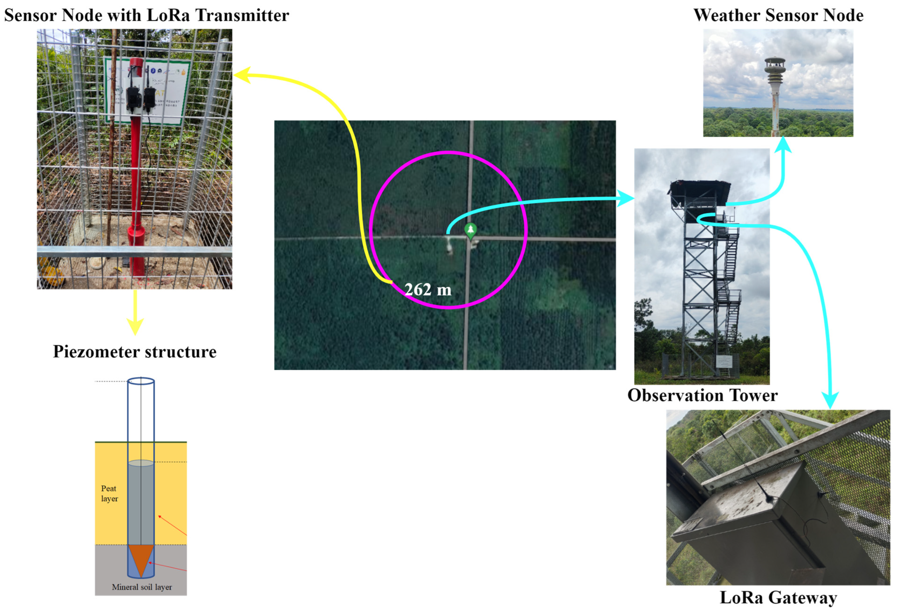
The distribution of peatland within the RMFR is displayed with the dark brown section indicating the extent of the peatland area. The vast peatland coverage within the reserve presents an ideal site for the current study. To facilitate data monitoring and collection, an IoT system was deployed in the peatland forest reserve, and the layout structure is shown in Figure 2. The system’s layout structure is designed to enable efficient and comprehensive monitoring of relevant parameters, providing real-time data that can aid in predicting and preventing forest fires. Integrating IoT technology into the study of peatlands holds great promise for advancing our understanding of these ecosystems and mitigating the risk of environmental disasters caused by forest fires. Moreover, the system has been used, and many research results based on the IoT system have been published [27,28,29].
The temperature, humidity, and rainfall data provided by METMalaysia were obtained from a meteorological station, which is situated at ground level, located approximately 8 km away from the IoT system in a direct line. The sensors in the IoT system used for measuring humidity, temperature, and rainfall were integrated into a weather station located approximately 20 m above the ground. The humidity sensor utilized a resistive sensing element. To evaluate the accuracy of the IoT measurements compared to the METMalaysia data, we refer to Section 3.1, where a detailed comparison is presented.
It is important to note that the meteorological stations used by the Malaysian Meteorological Department for weather monitoring are located approximately 8 km from our IoT system. METMalaysia currently possesses 43 main meteorological stations and 221 auxiliary meteorological stations [30]. Moreover, the meteorological data, including rainfall, temperature, humidity, and predicted DMC, obtained from the meteorological stations around 8 km from our IoT system, adequately cover and apply to the peatland forest areas where our IoT system is deployed. This ensures that the meteorological data used for calculations and predictions within our IoT system align with the specific conditions of the target peatland forest region. By utilizing the data collected from the meteorological stations near our IoT system, we can effectively monitor and incorporate accurate weather parameters, enabling reliable computation of DMC values and relevant predictions within the designated peatland forest areas.
Figure 2 shows the IoT system deployed in RMFR for peatland data monitoring. The system comprises an observation tower, a LoRaWAN gateway for data reception, a weather sensor node for measuring relative humidity and rainfall, a sensor node for monitoring and transmitting peatland groundwater level (GWL) data, and a LoRaWAN transmitter. The sensor node for measuring GWL is located at the southwest corner of the observation station, about 262 m in the direction of 8 o’clock. It is surrounded by a one-meter-high fence to prevent wild animals from damaging the IoT system. It is worth noting that the GWL measurement is achieved utilizing a piezometer located in a UPVC pipe with a small hole and a depth of 5.26 m. The sensor is clamped at the bottom and measures the water level above the sensor based on the pressure.
To facilitate the smooth flow of groundwater within the pipeline, a small hole is incorporated while ensuring that the gap is not too large to prevent the piezometer from being obstructed by soil and stones. The pipeline is placed at a depth of 5.26 m to ensure the measurement of the actual groundwater level within the peat layer. These considerations are essential for accurately monitoring peatland parameters, as imprecise measurements could lead to inaccuracies in the Fire Weather Index (FWI) model and potentially undermine the effectiveness of mitigation efforts against forest fires.
Additionally, the IoT system can log the real-time measurement of relevant parameters every minute and transmit data to the LoRaWAN gateway by LoRaWAN radio protocol [31], and the cellular network communication with LTE 4G will transfer data to the cloud for other data analytics processes.

2.2. Fire Weather Index (FWI) System

This paper involves a forest FWI system, which can help to predict the degree of danger of forest fire in peatlands and achieve the effect of quantifying various fire risk indicators by measuring the humidity, temperature, rainfall, and other parameters of the natural conditions in a specific area in real time.
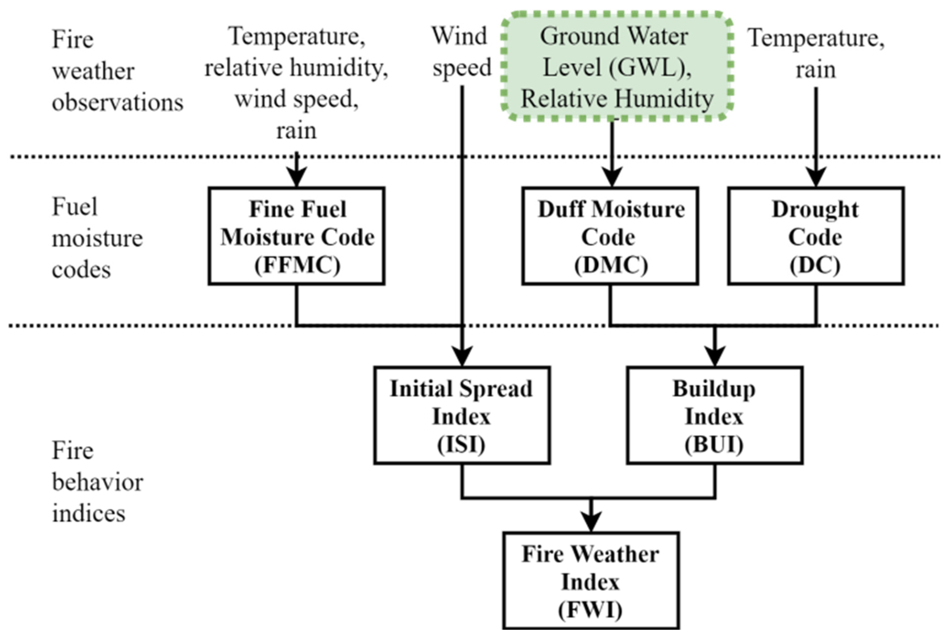
Furthermore, the Canadian Forest Fire Weather Index (FWI) system was developed as early as 1970 and revised in 1984 [32]. In 1987, Van Wagner [33] detailed the FWI system, as shown in Figure 3.
Figure 3 illustrates the system’s components, which include three fuel moisture codes—Fine Fuel Moisture Code (FFMC), Duff Moisture Code (DMC), and Drought Code (DC), as well as three fire behavior indexes—Initial Spread Index (ISI), Buildup Index (BUI), and Fire Weather Index (FWI). It is worth noting that forest fuel moisture rates vary depending on forest fuel type, with each having its special drying rate. Additionally, the moisture content of combustibles is subject to fluctuations due to daily weather changes. These nuances must be considered in calculating the Fire Weather Index (FWI) model to ensure its accuracy and reliability in predicting forest fire risks. Incorporating these elements into the system design enhances its data collection, processing, and analysis capacity, thereby contributing to improved peatland fire prevention and mitigation.
FFMC is a quantitative indicator reflecting the moisture of the surface litter layer and other mature fine combustibles (needles, mosses, and twigs less than 1 cm in diameter) [33]. DMC indicates the moderate depth of loose organic layer moisture, which is affected by rainfall, temperature, and relative humidity but not by wind speed. DC is the moisture indicator of the deep tight organic layer. ISI combines FFMC and wind speed to express the expected fire spread speed. BUI is the sum of DMC and DC weights, indicating the total amount of effective combustibles the moving fire line burns. FWI combines ISI and BUI and quantitatively indicates potential fire intensity. These indicators of the FWI system provide important quantitative reference data for forest fire management activities.
This system is widely used in Canada and other countries but does not consider different forest types. Therefore, for peatland forests in tropical areas with rich groundwater, the innovation of this study is to design a model suitable for the characteristics of peatland forests in tropical areas to integrate groundwater levels into the FWI system, as shown in Figure 4.
Figure 4 depicts the integration of groundwater level (GWL) into the Fire Weather Index (FWI) system. Previous studies have confirmed the viability of using GWL in place of temperature and rainfall to compute the Drought Code (DC) in the FWI system [28]. Precisely, the Duff Moisture Code (DMC) is calculated using GWL and relative humidity, as opposed to temperature, rainfall, and relative humidity in the original Canadian FWI system (refer to Figure 3). This modification to the FWI system improves its ability to accurately predict and prevent peatland forest fires.
The advantage of using groundwater level (GWL) data to calculate the Duff Moisture Code (DMC) lies in its consideration of the specific conditions in Malaysian peatlands. Given Malaysia’s tropical climate characterized by heavy rainfall, significant amounts of groundwater are present in these areas. Consequently, we propose an innovative approach to synthesizing GWL data to estimate soil moisture in peatland regions.
Our method is not intended to replace the existing FWI system but instead aims to introduce a localized approach explicitly tailored to the tropical peatland forests of Malaysia. Our IoT-based DMC calculation relies on GWL data obtained from ground sensor nodes, as depicted in Figure 2. Moreover, it is crucial to note that the IoT system enables automatic computation without requiring manual calculations based on formulas. This means that our IoT system can continuously monitor and display weather parameters such as rainfall, temperature, and humidity, as well as GWL data from the ground sensor nodes. The proposed algorithm can automatically calculate and display DMC values in real time, eliminating the time-consuming manual calculations.
Therefore, the advantages of using groundwater level (GWL) to calculate the Duff Moisture Code (DMC) for tropical peatland forests can be summarized as follows:
Relevance to Peatland Ecosystem: Tropical peatland forests are characterized by a thick layer of organic material called peat. The groundwater level is a crucial factor affecting the moisture content of peat, as it influences the water table and the overall hydrological conditions [34]. Incorporating groundwater level into the DMC calculation can capture the specific moisture dynamics of peatland ecosystems.
Reflects Local Conditions: Groundwater level directly measures the water availability in the specific peatland area [35]. It considers the local hydrological characteristics, such as rainfall patterns, drainage, and evaporation rates [36]. Considering these factors, the DMC calculation becomes more representative of the moisture conditions in the tropical peatland forest.
Long-Term Moisture Dynamics: Groundwater level represents the long-term water availability in peatland ecosystems [37]. Unlike surface water or precipitation, groundwater is often more stable and persists longer [38]. Incorporating groundwater level into the DMC calculation allows us to assess the moisture conditions over a longer period, capturing seasonal variations and enabling better fire risk prediction in tropical peatland forests.
Improved Fire Risk Assessment: DMC estimates the fire danger rating and potential fire behavior. Considering groundwater level can enhance the accuracy of fire risk assessment in tropical peatland forests [39]. Peatlands are highly vulnerable to fires, and their management and conservation depend on accurate fire risk evaluations. Groundwater-informed DMC can contribute to more effective fire prevention and management strategies.
Informing Land Management Decisions: Groundwater-informed DMC can provide valuable information for land managers and decision-makers in tropical peatland forests [40]. Understanding the moisture conditions derived from groundwater level data enables them to make informed decisions regarding land use planning, fire risk mitigation, and sustainable resource management.
In addition, the use of groundwater level to calculate the Duff Moisture Code for peatland forests in Malaysia also has the following advantages.
Peatland Extent: Malaysia has a significant extent of peatland forests, particularly in the states of Sarawak and Sabah on the island of Borneo [41]. Thick layers of organic peat material and unique hydrological conditions characterize these peatlands [42]. Incorporating groundwater level data into the DMC calculation allows for a more accurate representation of the moisture dynamics specific to Malaysian peatland forests.
High Fire Risk: Peatlands in Malaysia are highly susceptible to fires, especially during prolonged dry periods [43]. The peat soils can become highly flammable when dried out, and once ignited, these fires can be challenging to control and extinguish [44]. Incorporating groundwater level data into the DMC calculation helps better assess the moisture conditions and fire risk specific to Malaysian peatland forests. This information can assist in fire prevention and management strategies, helping to protect these valuable ecosystems.
Hydrological Variability: Malaysia experiences precipitation patterns and climate variations across different regions and seasons [45]. Groundwater level data captures the local hydrological variability, considering the specific characteristics of Malaysian peatland ecosystems [46]. This information enhances the accuracy of the DMC calculation, enabling a more precise assessment of moisture conditions and fire risk in Malaysian peatland forests.
Sustainable Resource Management: Malaysian peatland forests are valuable ecosystems that provide essential ecosystem services and support biodiversity. They contribute to local livelihoods through agriculture, timber extraction, and ecotourism [47]. Land managers and decision-makers can make more informed choices regarding sustainable resource management practices using groundwater-informed DMC [48]. This helps to balance economic development with the conservation and protection of Malaysian peatland forests.
Climate Change Mitigation: Peatlands play a vital role in climate change mitigation by storing large amounts of carbon. However, when peatlands are degraded or subjected to fires, significant amounts of greenhouse gases are released into the atmosphere [49]. Accurate assessment of fire risk using groundwater-informed DMC can aid in preventing peatland fires [50], which helps to maintain the carbon sequestration capacity of Malaysian peatland forests and mitigate climate change impacts.
In summary, the utilization of GWL data in the calculation of DMC offers the advantage of accounting for the specific conditions of Malaysian tropical peatland forests characterized by abundant groundwater due to high rainfall. Moreover, incorporating groundwater level data into the DMC calculation for Malaysian peatland forests provides specific advantages that enable better fire risk assessment, improved resource management, and enhanced climate change mitigation efforts. Our approach aims to complement, rather than replace, the existing FWI system by proposing a localized method tailored to the unique characteristics of this peatland region. Furthermore, our IoT-based system enables real-time monitoring and display of weather parameters and GWL data and automated DMC computation, eliminating manual calculations.

2.3. Algorithms for Evaporation Rate

The Duff Moisture Code (DMC) is a parameter that measures the moisture content of organic matter with a middle layer thickness ranging from 5 to 10 cm and a dry mass of 5.00 kg/m2, according to Groot et al. [51]. DMC represents the moisture content in the middle–lower deciduous layer and me-dium ligneous material, indicating fuel consumption in the forest. The DMC algorithm model of the FWI system in Canada (referred to as Algorithm 1) is a simple exponential water exchange model, meaning the previous day’s value is required.
Algorithm 1. DMC model of Canadian FWI system [52]
Input: rainfall as R, temperature as T, humidity as H, DMC of the previous day as dmc0.
Output: DMC
  if    R > 1.5
         Re = 0.92 ∗ R − 1.27
         Mo = 20.0 + 280.0/exp(0.023 ∗ dmc0)
                 if          dmc0 <= 33.0
                         b = 100.0/(0.5 + 0.3 ∗ dmc0)
                 elseif    dmc0 > 33.0 & dmc0 <= 65.0
                         b = 14.0 − 1.3 ∗ log(dmc0)
                 else
                         b = 6.2 ∗ log(dmc0) − 17.2
                 end if
         Mr = Mo + (1000 ∗ Re)/(48.77 + b ∗ Re)
         Pr = 43.43 ∗ (5.6348 − log(Mr − 20.0))
         K = 1.894 ∗ (T + 1.1) ∗ (100 − H) ∗ 12 ∗ 0.0001
         DMC = Pr + 100 ∗ K
  else 
         K = 1.894 ∗ (T + 1.1) ∗ (100 − H) ∗ 12 ∗ 0.0001
         DMC = dmc0 + 100 ∗ K
  end if
  return  DMC
In Algorithm 1, Re refers to the adequate rainfall, Mo refers to the moisture content of the previous day, dmc0 refers to the DMC of the previous day, Mr refers to the moisture content after rainfall, b refers to the reaction factor of DMC after rainfall, Pr refers to the DMC after rainfall, and K refers to the drying rate.
The disadvantage of this algorithm is that it is highly dependent on the previous day’s data. Therefore, this paper proposes a model that can accurately calculate DMC by directly using the GWL and humidity parameters without considering the low complexity of the DMC of the previous day.
Table 1 presents the descriptive statistics of the key variables used in our study, namely groundwater level (GWL), humidity, rainfall, and temperature. The table provides an overview of the dataset, including each variable’s count, mean, standard deviation, minimum, 25th percentile, median, 75th percentile, and maximum values. These statistics offer insights into the distribution and range of the environmental parameters measured in the Malaysian peat forest area. The dataset comprises 47,306 observations, providing a robust foundation for our analysis and subsequent calculations. The inclusion of this table enhances the transparency and comprehensibility of our research findings, allowing readers to gain a better understanding of the characteristics of the collected data.
In this paper, 70% of the data samples (i.e., 33,114 samples) are used for curve fitting model training, and the remaining 30% (i.e., 14,192 samples) are used to verify the accuracy of the curve fitting model. The 70% sample data selection rule is to randomly select 70% of the data at different times each day.
Moreover, 70% of the data, which are the DMC published by METMalaysia, the groundwater level (GWL), and the humidity measured by the IoT system, are curve fitted differently.

2.4. Linear_DMC Model

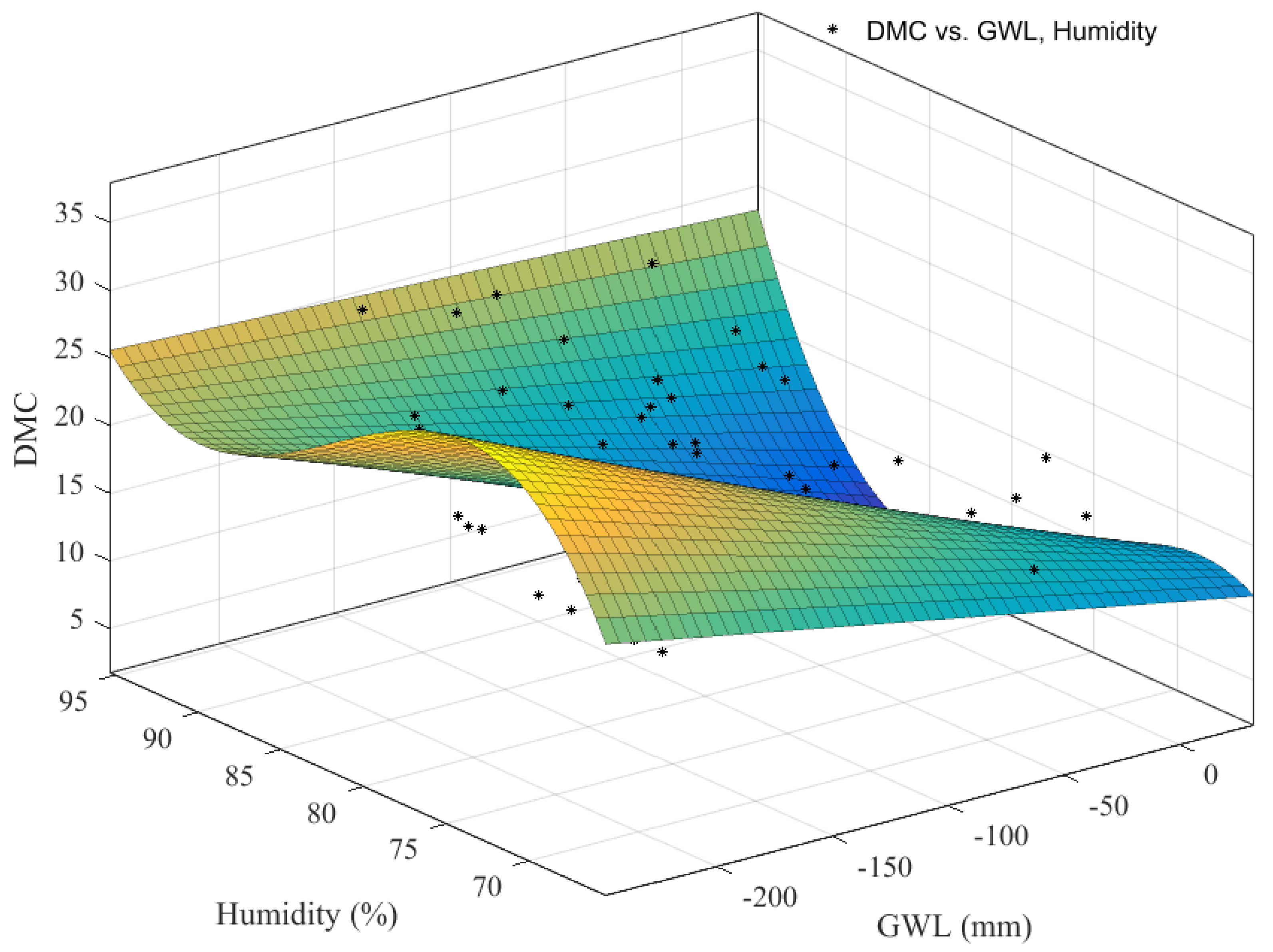
The 33,114-sample data of groundwater level and humidity measured by the IoT system are fitted in linear curves with the data of DMC published by METMalaysia in the same period in 2020. The formula for calculating DMC using GWL and humidity can be obtained, as shown in Figure 5.
Figure 5 shows the curve fitting between DMC from METMalaysia between January and March 2020 and GWL and humidity from the Internet of Things system at RMFR obtained using the Linear Model Poly13 (referred to as Linear_DMC Model). The term Poly13 means that the maximum power exponent of GWL, g, is 1, and the maximum power exponent of humidity, h, is 3. The fitting equation can be expressed as follows:
D M C = g × ( 1.182 0.03258 × h + 0.0002108 × h 2 ) + 0.003829 × h 3 1647 0.8782 × h 2 + 66.44 × h
where DMC is the Duff Moisture Code, g is groundwater level (unit: mm), and h is the relative humidity in the percentage system.

2.5. Linear_Mixed_DMC Model

In order to capture the complex patterns and dynamics present in the data, we employed a trigonometric model with a linear combination approach. The trigonometric model incorporates sinusoidal functions that represent linear and nonlinear relationships among the variables. By incorporating these trigonometric functions, the model gains the ability to capture periodic variations and intricate patterns that a simple linear model may not adequately capture. This enhanced flexibility allows for a more accurate representation of the intricate interactions between the variables and provides a more comprehensive understanding of the underlying dynamics. Furthermore, the linear combination approach enables the model to adaptively weigh the contributions of different components, thereby allowing for a more nuanced and accurate representation of the data. The resulting mixed model exhibits improved goodness of fit, as evidenced by the reduced mean square error and better alignment with the actual DMC values reported by the Malaysian Meteorological Department. Therefore, the trigonometric model offers significant potential benefits for capturing the data’s complex patterns and underlying dynamics, providing a more accurate and comprehensive analysis of the DMC in the context of peat fire prediction and control.
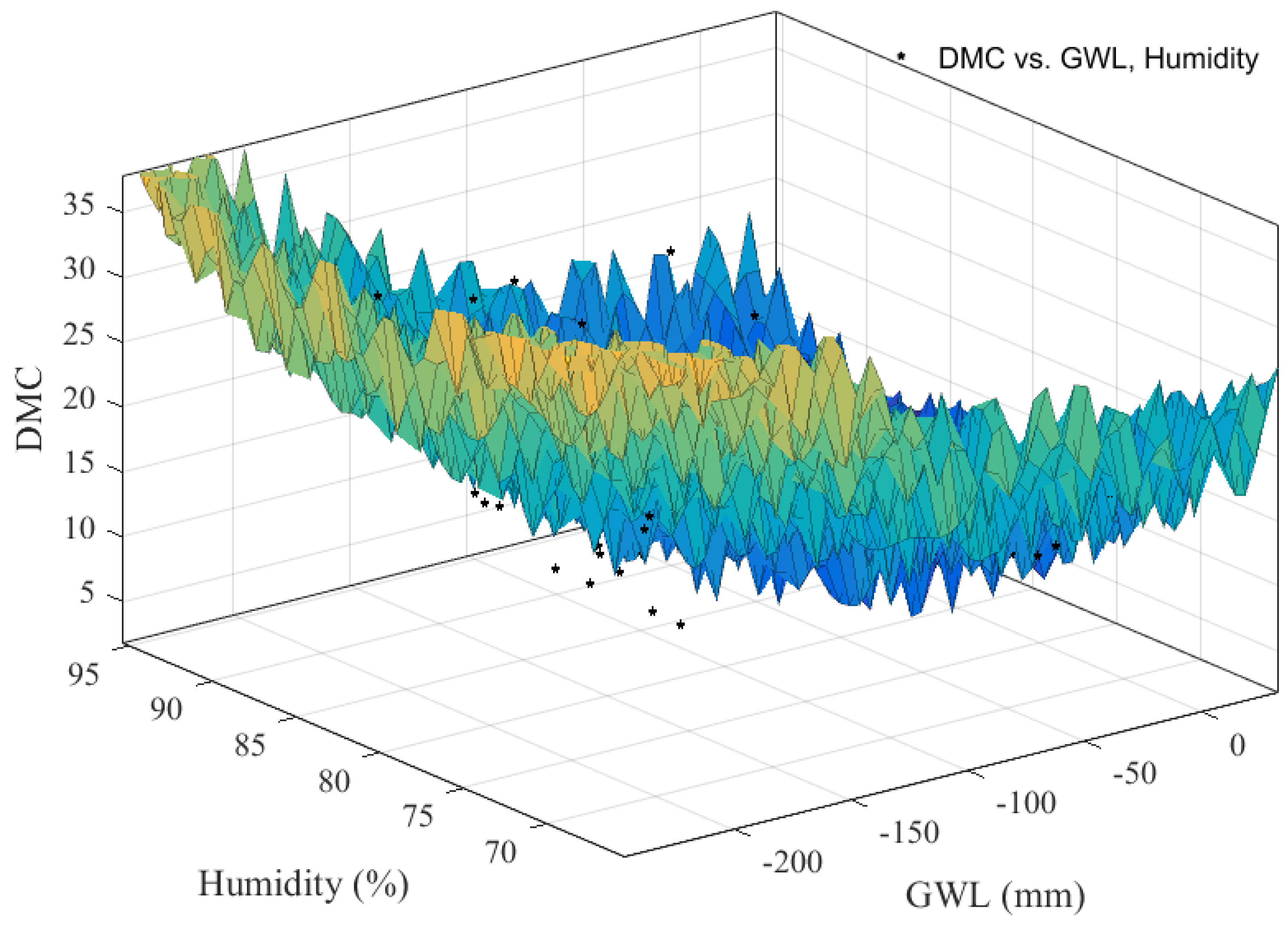
The 33114-sample data of groundwater level and humidity measured by the IoT system are fitted in linear mixed trigonometric function curves with the data of DMC published by METMalaysia in the same period. The formula for calculating DMC using GWL and humidity can be obtained, as shown in Figure 6.
Figure 6 shows the curve fitting between DMC from METMalaysia between January and March 2020 and groundwater level and humidity from the IoT system in RMFR obtained using trigonometric function and linear mixed model (referred to as Linear_Mixed_DMC Model). The fitting equation can be expressed as follows:
D M C = 346.2   0.02627 × g + 0.0002559 × g 2 8.094 × h + 0.0484 × h 2   2.452 × c o s ( 0.7233 × g ) + 2.776 × s i n ( 0.3306 × g × h ) +   c o s ( 0.9087 × h )
where DMC is the Duff Moisture Code, g is groundwater level (unit: mm), and h is the relative humidity in the percentage system.
In order to validate the accuracy of the DMC values derived from the Linear_DMC and Linear_Mixed_DMC models, we utilized the rainfall, temperature, and humidity data obtained through our IoT system. Figure 7a presents the goodness of fit achieved by the Linear_DMC model compared to the DMC values calculated using the IoT-monitored temperature, humidity, and rainfall data. The results demonstrate a correlation coefficient of 0.83 and a mean square error of 2.15.
Figure 7b showcases the results obtained from the Linear_Mixed_DMC model. The model exhibits a higher goodness of fit, with a correlation coefficient of 0.93 and a mean square error of 1.53. These results indicate a closer alignment between the DMC values derived from the Linear_Mixed_DMC model and the IoT-monitored temperature, humidity, and rainfall data.
Figure 7 provides a comprehensive evaluation of the performance of both the Linear_DMC and Linear_Mixed_DMC models in capturing the underlying patterns and dynamics of the DMC values. The high correlation coefficients and relatively low mean square errors reflect the capability of these models to estimate the DMC parameter using the IoT-collected meteorological data accurately. It shows here that the Linear_Mixed_DMC model performs better than the Linear_DMC model.

3. Results and Discussion

This section mainly shows the correlation between the IoT system deployed in this study and the weather parameters published by METMalaysia (3°24′11.69″ N, 101°24′14.33″ E) in the same period, proving the feasibility of using the parameters measured by the IoT system to calculate the fire weather index. In addition, the model’s accuracy is verified by comparing the DMC value calculated by the proposed model with the value published by METMalaysia.

3.1. Results of Data Validation

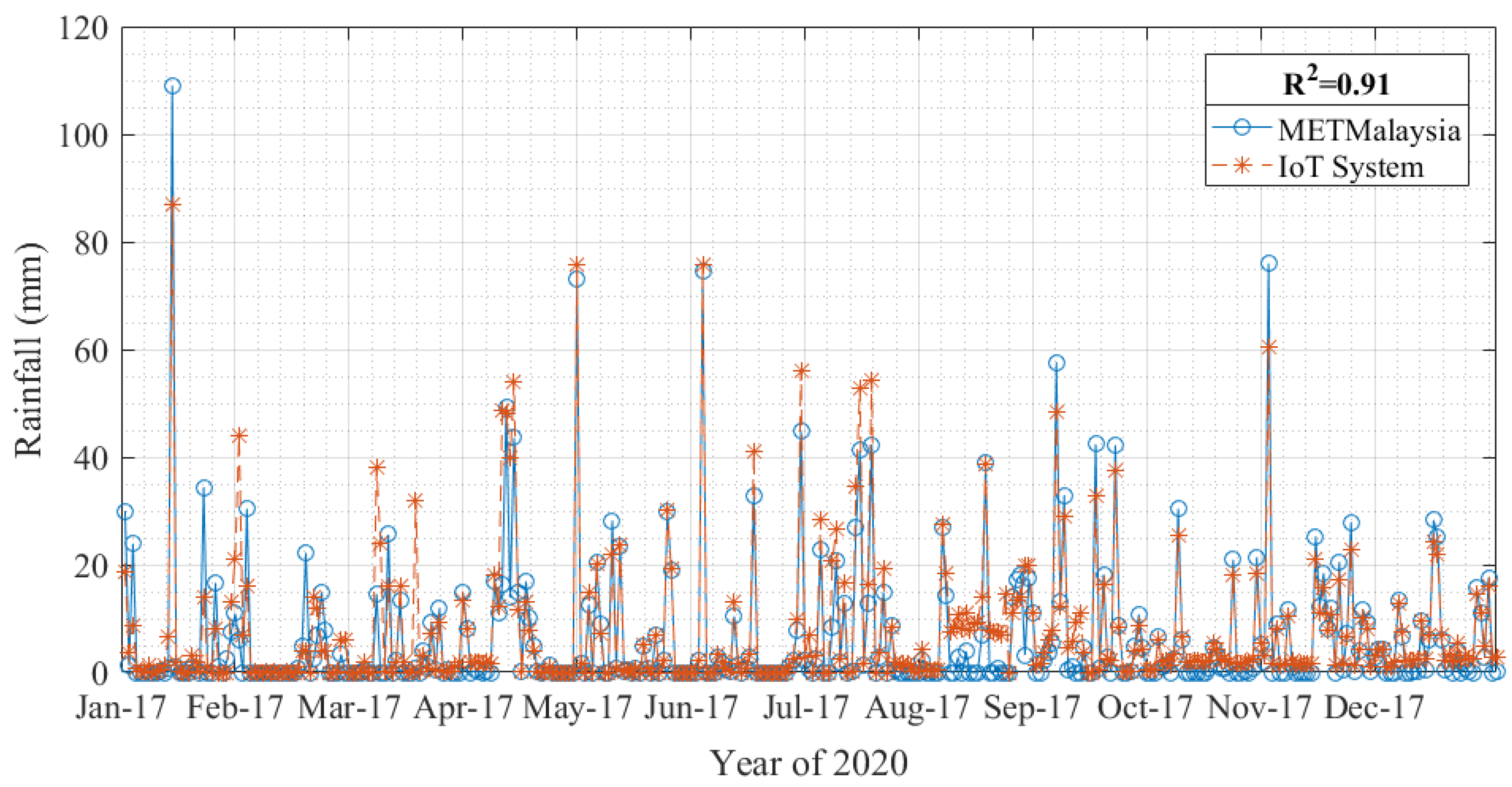
The data in this paper are all from the measurement of the IoT system in 2020, as presented in Section 2.1. The system can measure the cycle time of each response as one minute. The comparison of single-day total rainfall between the IoT system and METMalaysia is shown in Figure 8.
Figure 8 compares the daily rainfall from the IoT system and METMalaysia in the same period in 2020 from 17 January. The IoT system and METMalaysia have the same collection standard for daily rainfall: the single-day total rainfall recording cycle is 24 h from 8 am to 8 am of the next day. It can be seen from the figure that the IoT system and METMalaysia have a high correlation (Represented by R2) of 0.91 for the data of single-day rainfall, which proves that the measurement of the IoT system is effective.
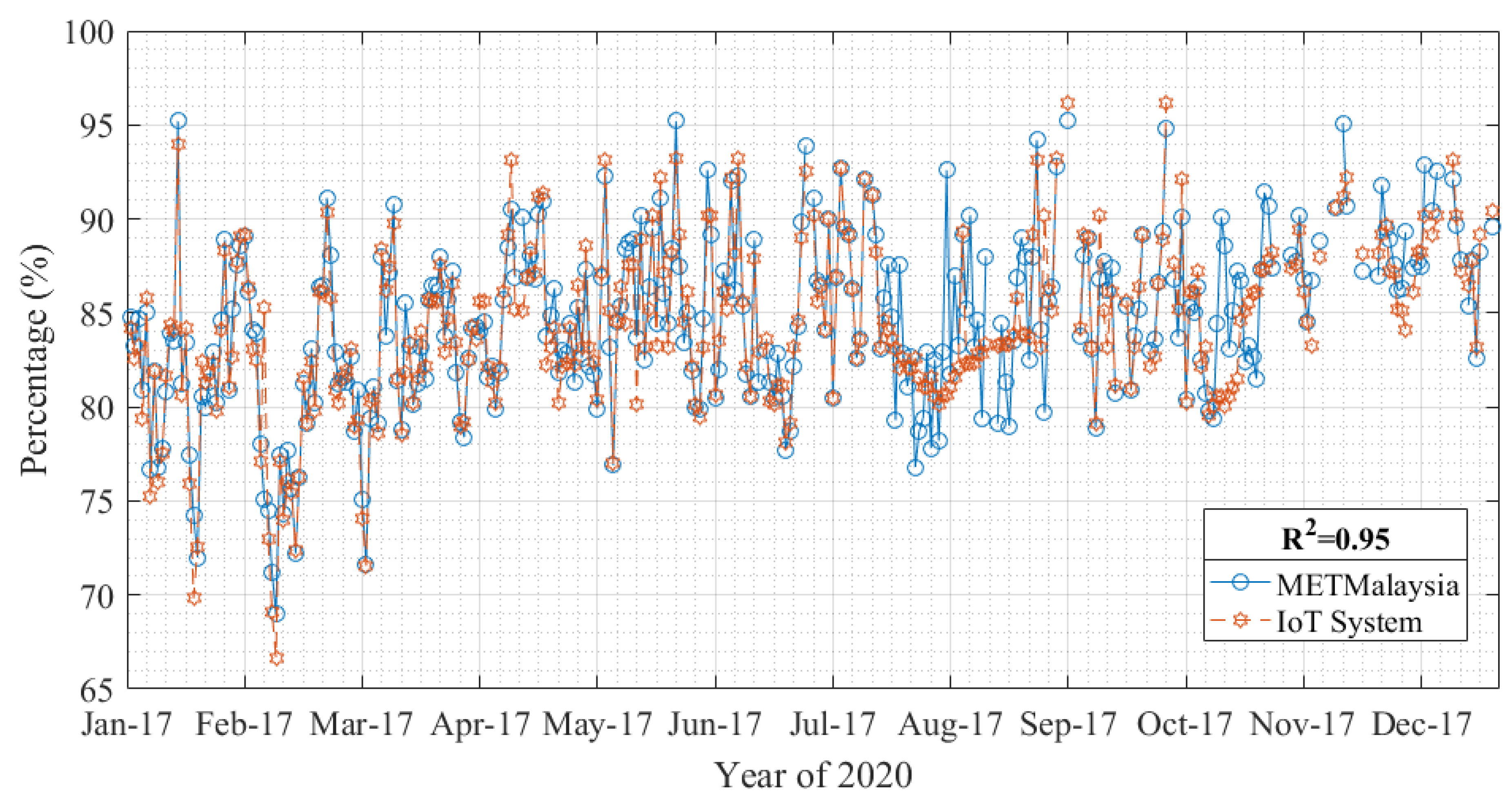
Figure 9 shows the comparison of annual daily average humidity from the IoT system and METMalaysia in the same period in 2020 from 17 January. Daily average humidity is the average value of humidity always recorded from 0:00 to 24:00 of the day. The figure shows that the trend of annual humidity of METMalaysia and the IoT system is highly correlated, and the correlation is 0.95.
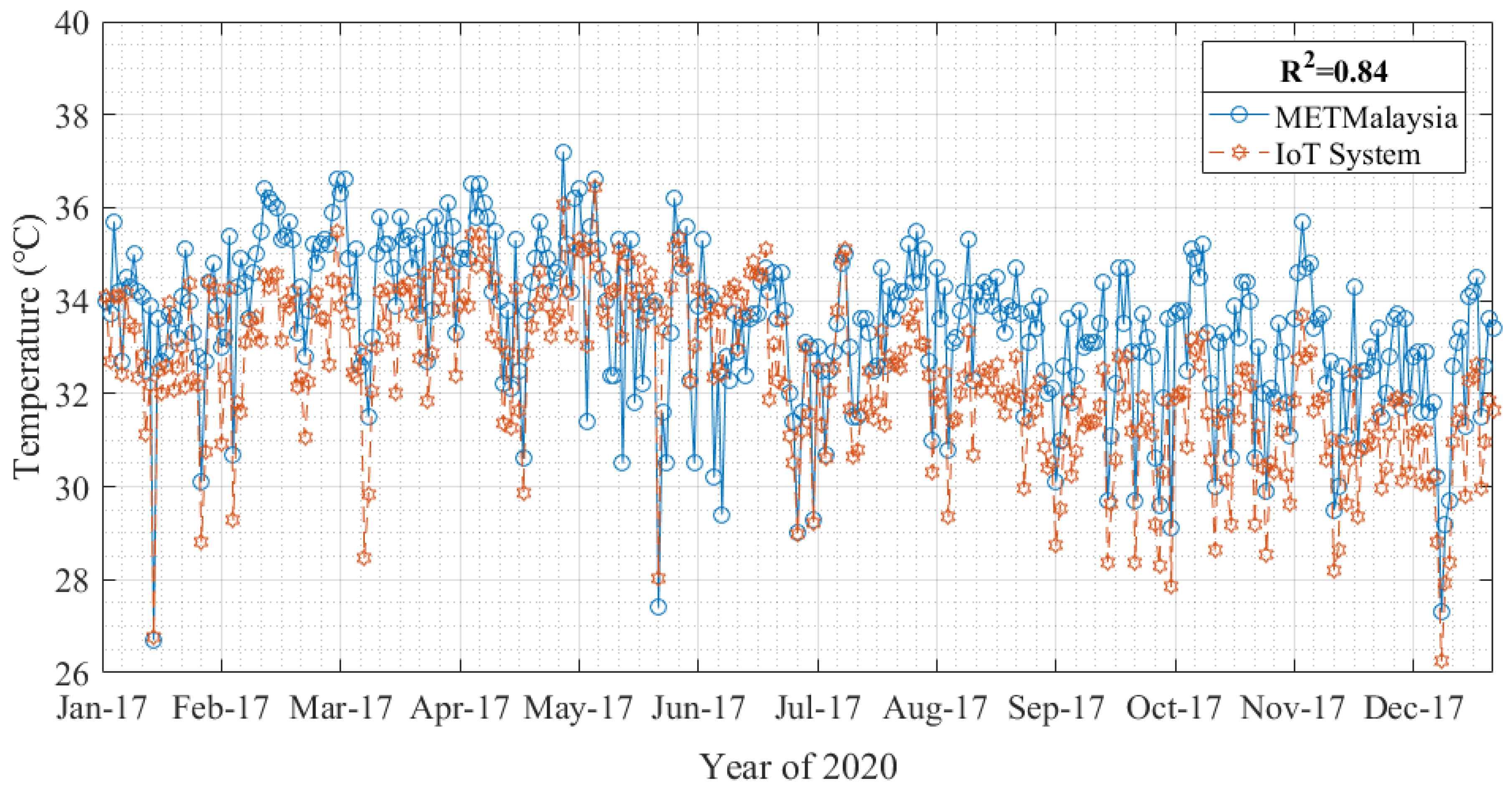
Figure 10 compares the daily maximum temperature from the IoT system and METMalaysia in the same period in 2020 from 17 January. The daily maximum temperature is the maximum value of the temperature recorded from 0:00 to 24:00. The figure shows that the trend of the annual daily maximum temperature of the IoT system and METMalaysia is roughly the same and reaches a high correlation of 0.84. However, the daily maximum temperature published by METMalaysia is higher than the daily maximum temperature data measured by the IoT system because the weather sensor in the IoT system is located about 25 m from the ground. In comparison, the measurement sensor in METMalaysia is situated about 1 m from the ground.
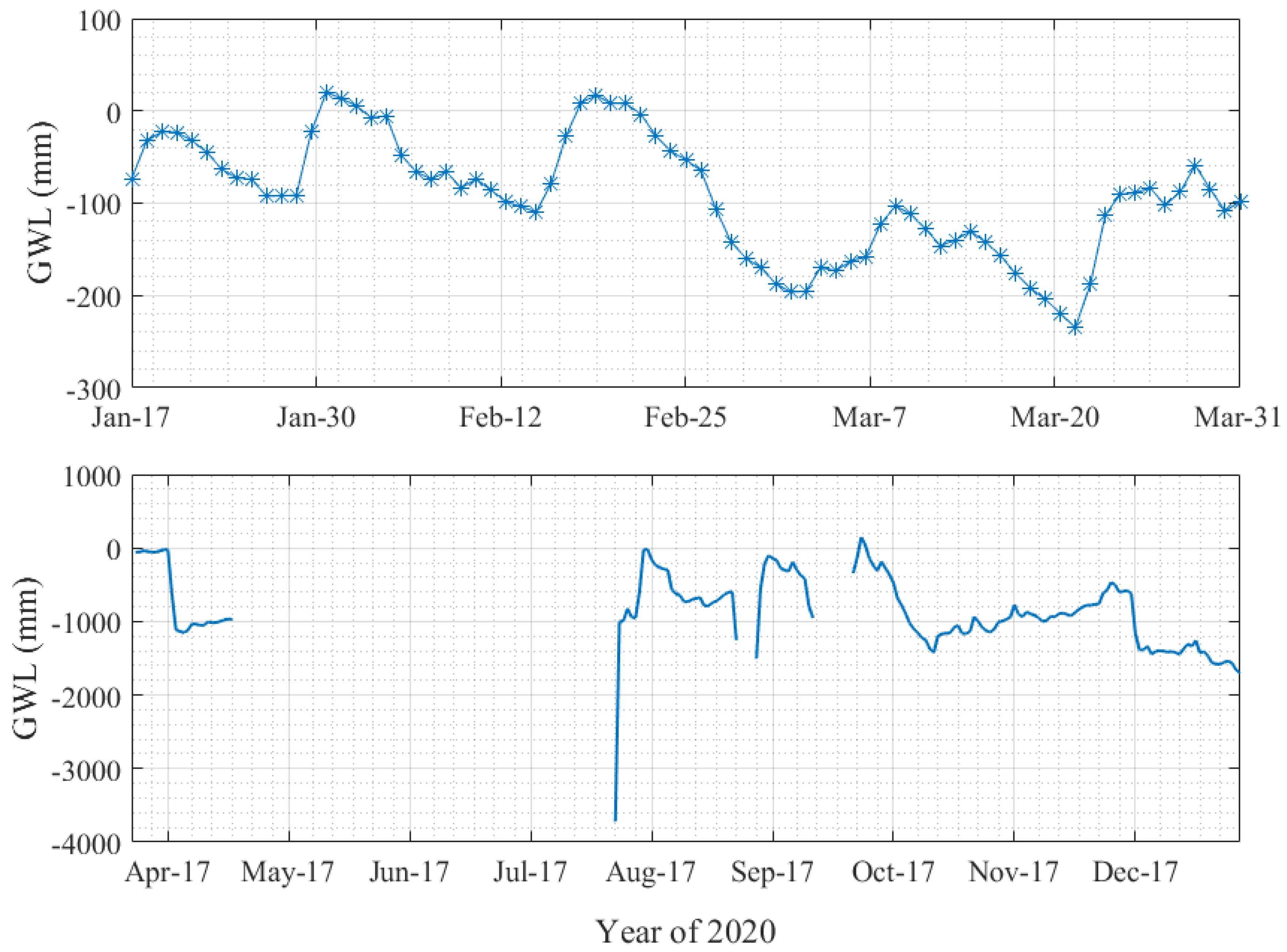
Figure 11 shows the distribution of the daily average groundwater level measured by the IoT system in 2020 from 17 January. The daily average groundwater level is the average of the GWL values measured and recorded every other minute from 0:00 to 24:00 daily. It can be seen that Figure 10 is divided into two parts. From 17 January to 31 March, the upper part is relatively continuous and stable and can be used for research. However, data were lost from April to December, and the data fluctuation range was too large to be used as objective scientific research data. The main reason is that Malaysia was in a closed state during the COVID-19 pandemic [53], so the IoT system could not be maintained and inspected. Therefore, this study uses the data from 17 January to 31 March, when the groundwater level performance was relatively stable, as the dataset for research and demonstration. In addition, to improve the research data’s reliability, this paper chooses the measured value per minute from 17 January to 31 March 2020 (i.e., 97,285 samples), after removing the missing values and anomalies from the research data (i.e., 47,306 samples).

3.2. Results of The Proposed Model

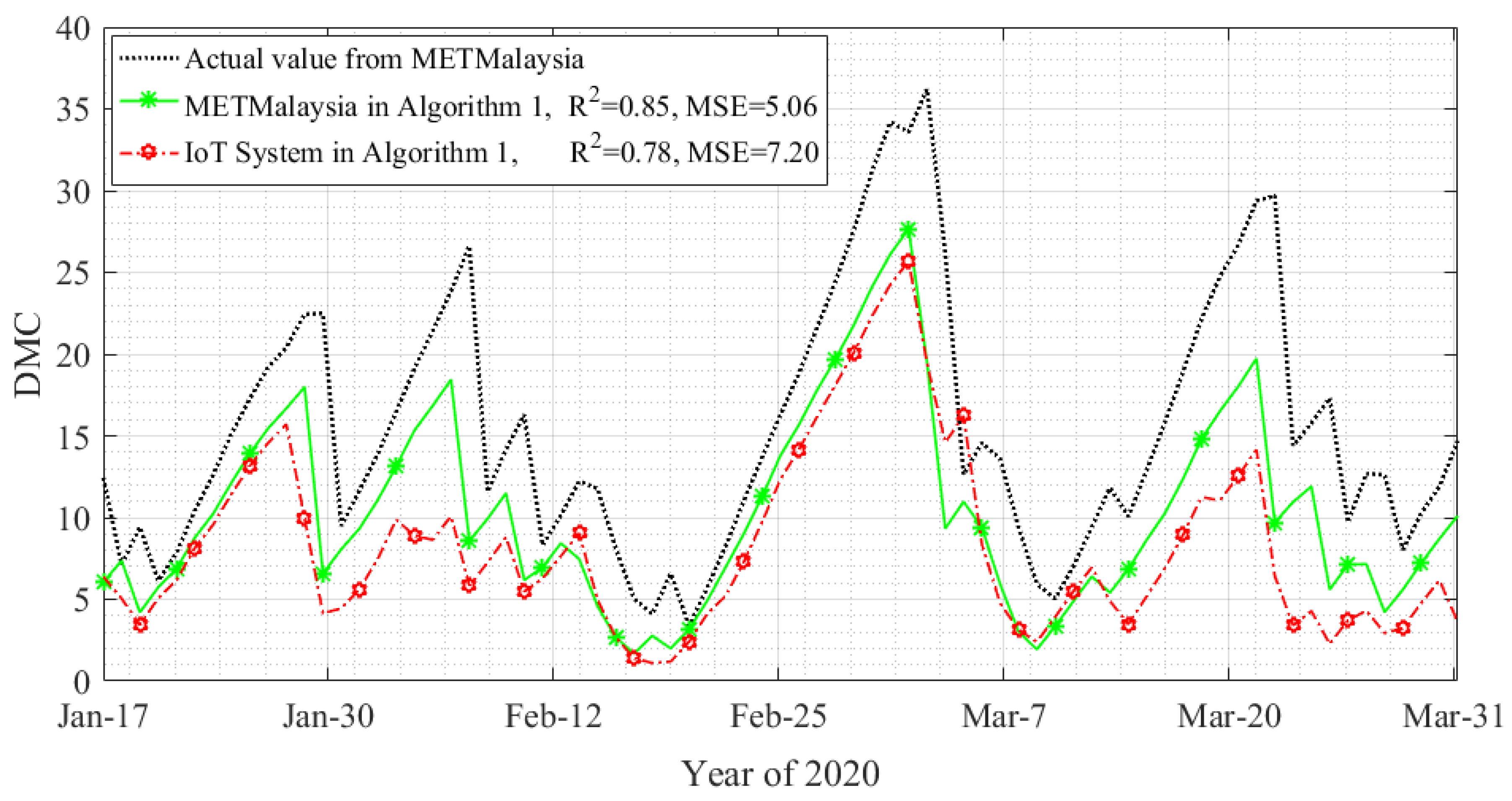
The Canadian FWI system calculates the DMC (refer to Algorithm 1). The measured values of the IoT system and the weather parameters (i.e., temperature, humidity, and rainfall) published by METMalaysia are calculated to compare DMC with the actual DMC published by METMalaysia, as shown in Figure 12.
Figure 12 shows the comparison of DMC calculation based on the Canadian model using the Internet of Things system and METMalaysia data. The DMC calculated using the weather parameters published by METMalaysia and the actual DMC value published by METMalaysia through the Canadian FWI system method has a high correlation of up to 0.85, and the mean square error (MSE) is 5.06. However, the DMC calculated using the IoT system based on the Canadian model performs poorly, and its MSE reaches 7.20, even if the correlation can reach 0.78. However, this performance is similar to that calculated using the data published by METMalaysia. Therefore, proposing a model with a higher correlation and lower error is necessary, as shown in Figure 13.
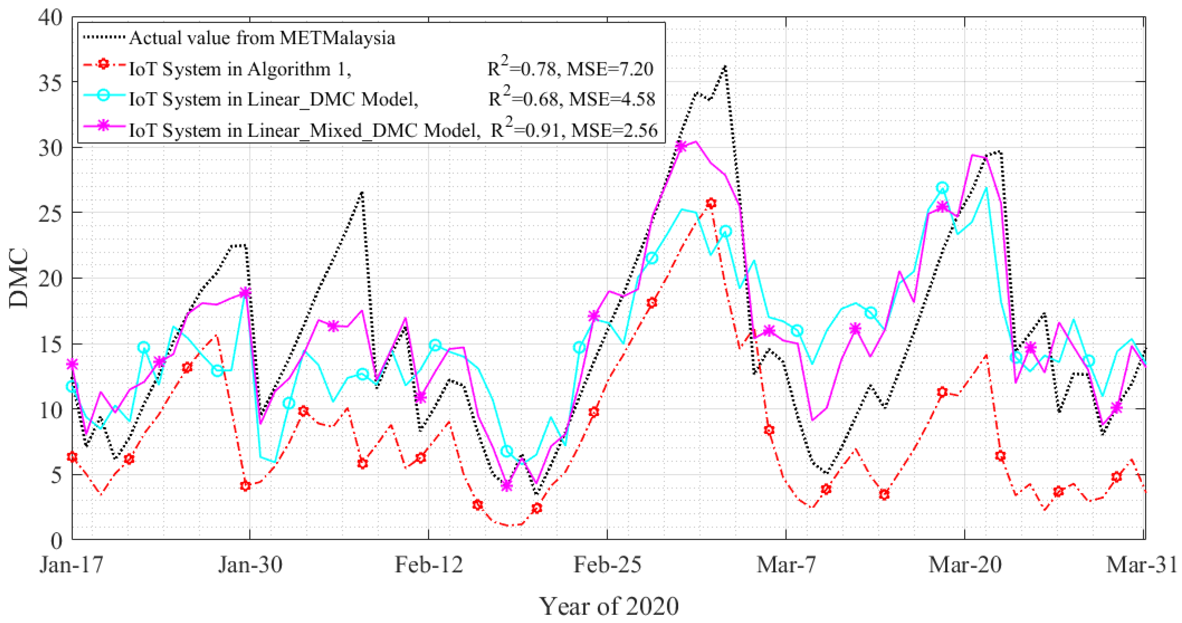
Figure 13 shows the comparison between the DMC calculated based on different models using the measurement data of the IoT system and the actual values published by METMalaysia. It can be seen from the figure that the mean square error of the Linear_DMC Model is lower than that of the Canadian model, only 4.58. At the same time, its correlation is unexpectedly reduced by about 0.1, which could indicate a better algorithm performance. Fortunately, Linear_Mixed_DMC Model performs better both in terms of correlation and mean square deviation; that is, the correlation is about 0.91, and the mean square error (MSE) is 2.56, which is a complete affirmation of the feasibility of using Linear_Mixed_DMC Model to calculate DMC using GWL and humidity. To make it easier to compare the performance of different models, refer to Table 2.
Table 2 compares the results of the three models and two data sources (i.e., IoT system and METMalaysia) involved in this paper. It shows that the proposed Linear_Mixed_DMC Model performs the best. While the differences between the METMalaysia results and the Linear_Mixed_DMC Model may appear somewhat distinct, it is essential to consider the inherent limitations of using generalized data for localized fire risk assessment. It is worth noting that access to METMalaysia’s extensive dataset comes with a cost, making it less accessible for researchers and practitioners working with limited resources. In contrast, the IoT system provides a cost-effective alternative by leveraging real-time monitoring capabilities and integrating groundwater level (GWL) data. This approach offers a substantial improvement in accurately assessing the moisture content of peatland and enables more precise and targeted fire prevention strategies. By capturing localized variations and providing continuous measurements of key parameters, such as GWL and humidity, the IoT system facilitates early detection of changes in peatland conditions, allowing for proactive fire prevention measures. While the initial investment in the IoT system may incur costs, the long-term benefits outweigh them, as it significantly reduces the risk of fire incidents and associated economic and environmental damages.
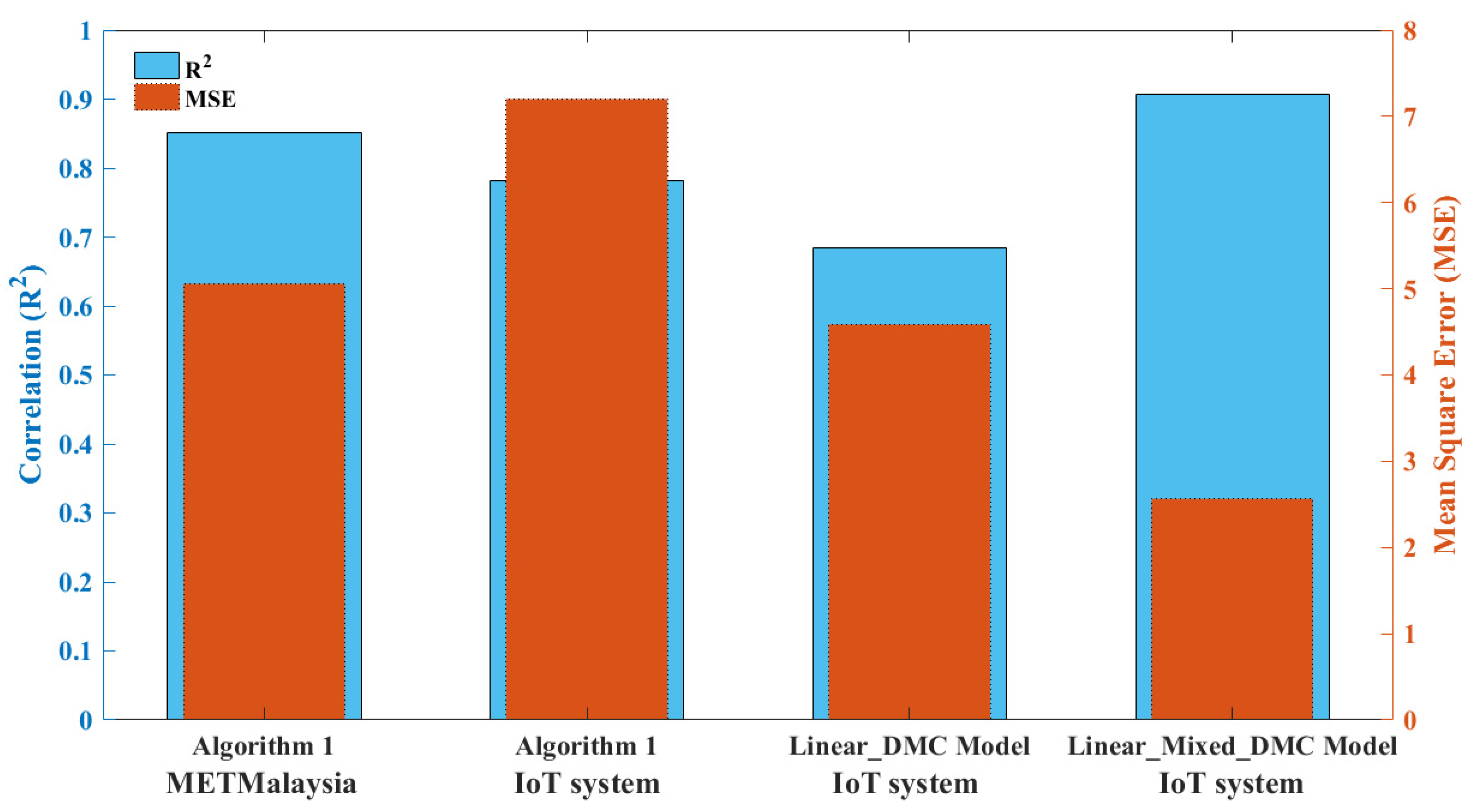
In order to facilitate a more comprehensive comparison of the performance of different models, a bar chart was also created, as shown in Figure 14. This visualization allows for a clear and concise representation of the differences in model performance, providing additional insight beyond the tabular data.
This paper demonstrated the effectiveness of the proposed IoT system for peatland monitoring and management. The real-time data collected from the IoT sensors allowed for comprehensive monitoring of key parameters such as groundwater level and humidity, which are crucial for assessing fire risk in peatland areas. Integrating these data into the FWI model, specifically the Linear_Mixed_DMC Model, showed improved accuracy and performance compared to the traditional Canadian FWI system. This highlights the potential of IoT technology in enhancing fire prevention and management strategies in tropical peatland forests. Furthermore, comparing DMC calculations based on the IoT system with METMalaysia data revealed the value of using localized and real-time data for more accurate predictions. These findings contribute to the existing literature by providing valuable insights into the application of IoT systems for peatland fire prevention and management.

4. Conclusions

This paper first verified the feasibility of an IoT system deployed in the Raja Musa Forest Reserve (RMFR) for peatland monitoring and management by comparing it with data published by METMalaysia in the same period. Then, based on Canada’s Fire Weather Index (FWI) model, a more efficient model for calculating DMC by integrating groundwater level (GWL) into the FWI system was proposed, and this model is suitable for tropical peatland forests. In this paper, the proposed models (i.e., Linear_Mixed_DMC Model and Linear_DMC Model) have the advantages of lower complexity and no dependence on the previous period’s values because the models do not need to consider the last calculation value to carry out the iteration as the Canadian FWI system (i.e., Algorithm 1) does. They only need to consider the current GWL and humidity to calculate a more accurate DMC. This finding can make an indelible economic contribution to supporting fire prevention and fire management decision making for peatland forests in tropical areas.
Future research could explore the scalability and adaptability of the IoT system in different peatland ecosystems and geographical regions to assess its transferability and effectiveness in diverse settings. Additionally, developing predictive models that incorporate machine learning algorithms and data analytics techniques can enhance the predictive capabilities of the IoT system, enabling early detection and proactive fire prevention measures. Lastly, the socio-economic impact and cost-effectiveness analysis of implementing IoT-based fire prevention systems should be investigated to provide a comprehensive understanding of the practical implications and benefits for stakeholders. By addressing these research gaps, we can further advance our knowledge, contribute to the sustainable management of peatland ecosystems, and mitigate fire risks.

Author Contributions

Conceptualization, L.L., A.S., N.A.A., I.S.S., L.S. and A.D.N.; Methodology, L.L., F.H., M.H. and S.M.R.; Software, L.L.; Validation, L.L. and S.M.R.; Formal analysis, L.L.; Investigation, L.L., A.S., M.H. and N.A.A.; Resources, L.L., A.S. and A.D.N.; Data curation, L.L. and N.A.A.; Writing—original draft, L.L.; Writing—review & editing, L.L., A.S., N.K.N., A.I., F.H., M.F.A.R., S.M.R., I.S.S. and L.S.; Visualization, L.L.; Supervision, A.S., N.K.N., A.I., F.H., M.F.A.R., I.S.S., L.S. and A.D.N.; Project administration, A.S. and M.H.; Funding acquisition, A.S. All authors have read and agreed to the published version of the manuscript.

Funding

This work was supported by Net-Peat: Networked ASEAN Peatland Communities for Transboundary Haze Alert under Grant UPM-NICT-APT 6380024-10801.

Institutional Review Board Statement

Not applicable.

Informed Consent Statement

Not applicable.

Data Availability Statement

Data available upon request.

Acknowledgments

The authors acknowledge the assistance of the respected editor and the anonymous referees for their insightful and constructive comments, which helped to improve the overall quality of the paper. The authors would like to acknowledge Selangor State Forestry Department (JPNS) for permission to deploy the IoT system in RMFR; and Global Environment Centre (GEC) for their valuable feedback and validation of peatland data.

Conflicts of Interest

The authors declare that they have no known competing financial interests or personal relationships that could have appeared to influence the work reported in this paper.

References

  1. Kayranli, B.; Scholz, M.; Mustafa, A.; Hedmark, A. Carbon storage and fluxes within freshwater wetlands: A critical review. Wetlands 2010, 30, 111–124. [Google Scholar] [CrossRef]
  2. Atyi, R.E. State of the Congo Basin Forests in 2021: Overall conclusions. In The Forests of the Congo Basin: State of the Forests; CIFOR: Bogor, Indonesia, 2021; Volume 2022, p. 367. [Google Scholar] [CrossRef]
  3. Keddy, P.A.; Fraser, L.H.; Solomeshch, A.I.; Junk, W.J.; Campbell, D.R.; Arroyo, M.T.K.; Alho, C.J.R. Wet and Wonderful: The World’s Largest Wetlands Are Conservation Priorities. Bioscience 2009, 59, 39–51. [Google Scholar] [CrossRef] [Green Version]
  4. Merchant, M.A.; Adams, J.R.; Berg, A.A.; Baltzer, J.L.; Quinton, W.L.; Chasmer, L.E. Contributions of C-Band SAR Data and Polarimetric Decompositions to Subarctic Boreal Peatland Mapping. IEEE J. Sel. Top. Appl. Earth Obs. Remote Sens. 2016, 10, 1467–1482. [Google Scholar] [CrossRef]
  5. Lees, K.J.; Artz, R.R.; Khomik, M.; Clark, J.M.; Ritson, J.; Hancock, M.H.; Cowie, N.R.; Quaife, T. Using Spectral Indices to Estimate Water Content and GPP in Sphagnum Moss and Other Peatland Vegetation. IEEE Trans. Geosci. Remote Sens. 2020, 58, 4547–4557. [Google Scholar] [CrossRef] [Green Version]
  6. Schlüter, S.; Leuther, F.; Albrecht, L.; Hoeschen, C.; Kilian, R.; Surey, R.; Mikutta, R.; Kaiser, K.; Mueller, C.W.; Vogel, H.-J. Microscale carbon distribution around pores and particulate organic matter varies with soil moisture regime. Nat. Commun. 2022, 13, 1–14. [Google Scholar] [CrossRef] [PubMed]
  7. Pavlov, D.S.; Striganova, B.R.; Bukvareva, E.N. An environment-oriented concept of nature use. Her. Russ. Acad. Sci. 2010, 80, 74–82. [Google Scholar] [CrossRef]
  8. Page, S.; Hoscilo, A.; Langner, A.; Tansey, K.; Siegert, F.; Limin, S.; Rieley, J. Tropical peatland fires in Southeast Asia. In Tropical Fire Ecology; Springer Praxis Books; Springer: Berlin/Heidelberg, Germany, 2009. [Google Scholar] [CrossRef]
  9. Stockwell, C.E.; Jayarathne, T.; Cochrane, M.A.; Ryan, K.C.; Putra, E.I.; Saharjo, B.H.; Nurhayati, A.D.; Albar, I.; Blake, D.R.; Simpson, I.J.; et al. Field measurements of trace gases and aerosols emitted by peat fires in Central Kalimantan, Indonesia, during the 2015 El Niño. Atmos. Chem. Phys. 2016, 16, 11711–11732. [Google Scholar] [CrossRef] [Green Version]
  10. Usup, A.; Hashimoto, Y.; Takahashi, H.; Hayasaka, H. Combustion and thermal characteristics of peat fire in tropical peatland in Central Kalimantan, Indonesia. Tropics 2004, 14, 1–19. [Google Scholar] [CrossRef] [Green Version]
  11. Adrianto, H.A.; Spracklen, D.V.; Arnold, S.R.; Sitanggang, I.S.; Syaufina, L. Forest and Land Fires Are Mainly Associated with Deforestation in Riau Province, Indonesia. Remote Sens. 2020, 12, 3. [Google Scholar] [CrossRef] [Green Version]
  12. Smith, T.E.H.; Evers, S.; Yule, C.M.; Gan, J.Y. In situ tropical peatland fire emission factors and their variability, as determined by field measurements in Peninsula Malaysia. Glob. Biogeochem. Cycles 2018, 32, 18–31. [Google Scholar] [CrossRef] [Green Version]
  13. Miettinen, J.; Shi, C.; Liew, S.C. Fire Distribution in Peninsular Malaysia, Sumatra and Borneo in 2015 with Special Emphasis on Peatland Fires. Environ. Manag. 2017, 60, 747–757. [Google Scholar] [CrossRef] [PubMed]
  14. Stefanidou, M.; Athanaselis, S.; Spiliopoulou, C. Health Impacts of Fire Smoke Inhalation. Inhal. Toxicol. 2008, 20, 761–766. [Google Scholar] [CrossRef]
  15. Lee, J.S.H.; Jaafar, Z.; Tan, A.K.J.; Carrasco, L.R.; Ewing, J.J.; Bickford, D.P.; Webb, E.L.; Koh, L.P. Toward clearer skies: Challenges in regulating transboundary haze in Southeast Asia. Environ. Sci. Policy 2016, 55, 87–95. [Google Scholar] [CrossRef]
  16. Novita, A.A.; Awumbila, S.S.; binti Nazrey, S.N. Transboundary Smoke-Haze Disaster Mitigation Efforts. In 2nd Annual International Conference on Business and Public Administration (AICoBPA 2019); Atlantis Press: Dordrecht, The Netherlands, 2020; pp. 311–314. [Google Scholar] [CrossRef]
  17. Apichai, S. Transboundary Haze Pollution Problem in Southeast Asia: Reframing ASEAN’s Response. No. DP-2015-82. 2015. Available online: https://ideas.repec.org/p/era/wpaper/dp-2015-82.html (accessed on 5 January 2023).
  18. Cheong, K.H.; Ngiam, N.J.; Morgan, G.G.; Pek, P.P.; Tan, B.Y.-Q.; Lai, J.W.; Koh, J.M.; Ong, M.E.H.; Ho, A.F.W. Acute Health Impacts of the Southeast Asian Transboundary Haze Problem—A Review. Int. J. Environ. Res. Public Health 2019, 16, 3286. [Google Scholar] [CrossRef] [PubMed] [Green Version]
  19. Sitanggang, I.S.; Syaufina, L.; Trisminingsih, R.; Ramdhany, D.; Nuradi, E.; Hidayat, M.F.A.; Rahmawan, H.; Wulandari; Ardiansyah, F.; Albar, I.; et al. Indonesian Forest and Land Fire Prevention Patrol System. Fire 2022, 5, 136. [Google Scholar] [CrossRef]
  20. Hikouei, I.S.; Eshleman, K.N.; Saharjo, B.H.; Graham, L.L.; Applegate, G.; Cochrane, M.A. Using machine learning algorithms to predict groundwater levels in Indonesian tropical peatlands. Sci. Total Environ. 2023, 857, 159701. [Google Scholar] [CrossRef] [PubMed]
  21. Widodo, J.; Izumi, Y.; Takahashi, A.; Kausarian, H.; Perissin, D.; Sri Sumantyo, J.T. Detection of Peat Fire Risk Area Based on Impedance Model and DInSAR Approaches Using ALOS-2 PALSAR-2 Data. IEEE Access 2019, 7, 22395–22407. [Google Scholar] [CrossRef]
  22. Davies, G.M.; Gray, A.; Power, S.C.; Domènech, R. Resilience of temperate peatland vegetation communities to wildfire depends upon burn severity and pre-fire species composition. Ecol. Evol. 2023, 13, e9912. [Google Scholar] [CrossRef]
  23. Kirkland, M.; Atkinson, P.W.; Pearce-Higgins, J.W.; De Jong, M.; Dowling, T.P.; Grummo, D.; Critchley, M.; Ashton-Butt, A. Landscape fires disproportionally affect high conservation value temperate peatlands, meadows, and deciduous forests, but only under low moisture conditions. Sci. Total Environ. 2023, 884, 163849. [Google Scholar] [CrossRef]
  24. Lupascu, M.; Wijedasa, L.S. Paludiculture as a sustainable land use alternative for tropical peatlands: A review. Sci. Total Environ. 2020, 753, 142111. [Google Scholar] [CrossRef]
  25. Rawluk, A.; Sanders, A.; Yuwati, T.W.; Rachmanadi, D.; Izazaya, N.; Yulianti, N.; Sakuntaladewi, N.; Dyson, A.; Graham, L.; Kunarso, A.; et al. Finding common ground: Developing a shared understanding of tropical peatswamp forest restoration and fires across culture, language, and discipline. Int. For. Rev. 2022, 24, 426–440. [Google Scholar] [CrossRef]
  26. Hiller, B.; Fisher, J. A Multifunctional. Scape Approach for Sustainable Management of Intact Ecosystems—A Review of Tropical Peatlands. Sustainability 2023, 15, 2484. [Google Scholar] [CrossRef]
  27. Sali, A.; Mohd Ali, A.; Ali, B.M.; Syed Ahmad Abdul Rahman, S.M.; Liew, J.T.; Saleh, N.L.; Nuruddin, A.A.; Razali, S.M.; Nsaif, I.G.; Ramli, N.; et al. Peatlands monitoring in Malaysia with IoT Systems: Preliminary experimental results. In Computational Intelligence in Information Systems: Proceedings of the Computational Intelligence in Information Systems Conference (CIIS 2020); Springer International Publishing: Cham, Switzerland, 2021; pp. 233–242. [Google Scholar] [CrossRef]
  28. Liew, J.T.; Sali, A.; Noordin, N.K.; Ali, B.M.; Hashim, F.; Mashohor, S.; Saleh, N.L.; Ouzrout, Y.; Sekhari, A. Sustainable peatland management with IoT and data analytics. In Smart and Sustainable Collaborative Networks 4.0, Proceedings of the 22nd IFIP WG 5.5 Working Conference on Virtual Enterprises, Saint-Étienne, France, 22–24 November 2021; PRO-VE 2021, Proceedings 22; Springer International Publishing: Cham, Switzerland, 2021; pp. 549–557. [Google Scholar] [CrossRef]
  29. Li, L.; Sali, A.; Liew, J.T.; Saleh, N.L.; Ahmad, S.M.S.; Ali, A.M.; Nuruddin, A.A.; Aziz, N.A.; Sitanggang, I.S.; Syaufina, L.; et al. Estimation of Ground Water Level (GWL) for Tropical Peatland Forest Using Machine Learning. IEEE Access 2022, 10, 126180–126187. [Google Scholar] [CrossRef]
  30. Laman Web Rasmi Jabatan Meteorologi Malaysia. Available online: https://www.met.gov.my/en/pendidikan/peralatan-meteorologi/#Automatic%20Weather%20System%20%20(AWS) (accessed on 14 June 2023).
  31. Zhao, L.; Wu, W.; Li, S. Design and Implementation of an IoT-Based Indoor Air Quality Detector With Multiple Communication Interfaces. IEEE Internet Things J. 2019, 6, 9621–9632. [Google Scholar] [CrossRef]
  32. Stocks, B.J.; Lawson, B.D.; Alexander, M.E.; Wagner, C.V.; McAlpine, R.S.; Lynham, T.J.; Dube, D.E. The Canadian forest fire danger rating system: An overview. For. Chron. 1989, 65, 450–457. [Google Scholar] [CrossRef]
  33. Van Wagner, C.E.; Petawawa, F. Development and Structure of the Canadian Forest Fireweather Index System; Forestry Technical Report; Canadian Forestry Service: Ottawa, ON, Canada, 1987; Volume 35, p. 19927. Available online: https://cfs.nrcan.gc.ca/publications?id=19927 (accessed on 5 February 2023).
  34. Taufik, M.; Widyastuti, M.T.; Sulaiman, A.; Murdiyarso, D.; Santikayasa, I.P.; Minasny, B. An improved drought-fire assessment for managing fire risks in tropical peatlands. Agric. For. Meteorol. 2022, 312, 108738. [Google Scholar] [CrossRef]
  35. Wu, S.; Tetzlaff, D.; Yang, X.; Soulsby, C. Disentangling the influence of landscape characteristics, hydroclimatic variability and land management on surface water NO3-N dynamics: Spatially distributed modeling over 30 yr in a lowland mixed land use catchment. Water Resour. Res. 2022, 58, e2021WR030566. [Google Scholar] [CrossRef]
  36. Taufik, M.; Veldhuizen, A.A.; Wösten, J.H.M.; Van Lanen, H.A.J. Exploration of the importance of physical properties of Indonesian peatlands to assess critical groundwater table depths, associated drought and fire hazard. Geoderma 2019, 347, 160–169. [Google Scholar] [CrossRef]
  37. Taufik, M.; Minasny, B.; McBratney, A.B.; Van Dam, J.C.; Jones, P.D.; Van Lanen, H.A.J. Human-induced changes in Indonesian peatlands increase drought severity. Environ. Res. Lett. 2020, 15, 084013. [Google Scholar] [CrossRef]
  38. Ahmad, S.; Liu, H.; Günther, A.; Couwenberg, J.; Lennartz, B. Long-term rewetting of degraded peatlands restores hydrological buffer function. Sci. Total Environ. 2020, 749, 141571. [Google Scholar] [CrossRef]
  39. King, R.; Richardson, S.; Walters, A.; Boesch, L.; Thomson, W.; Irons, J. Preliminary Evaluation of Environmental Issues on the Use of Peat as an Energy Source; (No. DOE/ET/10159-T21; TR-80/025-001); UOP/SDC, Joint Venture: McLean, VA, USA, 1980. [Google Scholar] [CrossRef] [Green Version]
  40. Kleine, L.; Tetzlaff, D.; Smith, A.; Goldhammer, T.; Soulsby, C. Using isotopes to understand landscape-scale connectivity in a groundwater-dominated, lowland catchment under drought conditions. Hydrol. Process. 2021, 35, e14197. [Google Scholar] [CrossRef]
  41. Wan Mohd Jaafar, W.S.; Said, N.F.S.; Abdul Maulud, K.N.; Uning, R.; Latif, M.T.; Muhmad Kamarulzaman, A.M.; Mohan, M.; Pradhan, B.; Saad, S.N.M.; Broadbent, E.N.; et al. Carbon Emissions from Oil Palm Induced Forest and Peatland Conversion in Sabah and Sarawak, Malaysia. Forests 2020, 11, 1285. [Google Scholar] [CrossRef]
  42. Melling, L. Peatland in Malaysia. In Tropical Peatland Ecosystems; Springer: Tokyo, Japan, 2016; pp. 59–73. [Google Scholar] [CrossRef]
  43. Musri, I.; Ainuddin, A.N.; Hyrul, M.H.I.; Hazandy, A.H.; Azani, A.M.; Mitra, U. Post forest fire management at tropical peat swamp forest: A review of Malaysian experience on rehabilitation and risk mitigation. IOP Conf. Ser. Earth Environ. Sci. 2020, 504, 012017. [Google Scholar] [CrossRef]
  44. Page, S.E.; Hooijer, A. In the line of fire: The peatlands of Southeast Asia. Philos. Trans. R. Soc. B Biol. Sci. 2016, 371, 20150176. [Google Scholar] [CrossRef] [PubMed] [Green Version]
  45. Tan, B.T.; Fam, P.S.; Firdaus, R.B.R.; Tan, M.L.; Gunaratne, M.S. Impact of Climate Change on Rice Yield in Malaysia: A Panel Data Analysis. Agriculture 2021, 11, 569. [Google Scholar] [CrossRef]
  46. Park, H.; Takeuchi, W.; Ichii, K. Satellite-Based Estimation of Carbon Dioxide Budget in Tropical Peatland Ecosystems. Remote Sens. 2020, 12, 250. [Google Scholar] [CrossRef] [Green Version]
  47. Nath, T.K.; Dahalan, M.P.B.; Parish, F.; Rengasamy, N. Local peoples’ appreciation on and contribution to conservation of peatland swamp forests: Experience from Peninsular Malaysia. Wetlands 2017, 37, 1067–1077. [Google Scholar] [CrossRef]
  48. Cochard, R. Scaling the costs of natural ecosystem degradation and biodiversity losses in Aceh Province, Sumatra. In Redefining Diversity & Dynamics of Natural Resources Management in Asia; Elsevier: Amsterdam, The Netherlands, 2017; Volume 1, pp. 231–271. [Google Scholar] [CrossRef]
  49. Murdiyarso, D.; Lilleskov, E.; Kolka, R. Tropical peatlands under siege: The need for evidence-based policies and strategies. Mitig. Adapt. Strateg. Glob. Chang. 2019, 24, 493–505. [Google Scholar] [CrossRef] [Green Version]
  50. Parish, F.; Lew, S.Y.; Mohd Hassan, A.H. National strategies on responsible management of tropical peatland in Malaysia. In Tropical Peatland Eco-Management; Springer: Singapore, 2021; pp. 677–723. [Google Scholar] [CrossRef]
  51. Groot, W.J.D.; Field, R.D.; Brady, M.A.; Roswintiarti, O.; Mohamad, M. Development of the Indonesian and Malaysian Fire Danger Rating systems. Mitig. Adapt. Strateg. Glob. Chang. 2007, 12, 165–180. [Google Scholar] [CrossRef] [Green Version]
  52. Van Wagner, C.E.; Pickett, T.L. Equations and Fortran Program for the Canadian Forest Fire Weather Index System; Forestry Technical Report 33; Canadian Forestry Service, Petawawa National Forestry Institute: Chalk River, ON, Canada, 1985; 18p, Available online: https://d1ied5g1xfgpx8.cloudfront.net/pdfs/19973.pdf (accessed on 5 February 2023).
  53. Hashim, J.H.; Adman, M.A.; Hashim, Z.; Mohd Radi, M.F.; Kwan, S.C. COVID-19 epidemic in Malaysia: Epidemic progression, challenges, and response. Front. Public Health 2021, 9, 560592. [Google Scholar] [CrossRef]
Figure 1. Peatland Distribution in RMFR (3°27′58″ N, 101°26′31″ E).
Fire 06 00272 g001
Figure 2. Deployment Structure of The IoT System.
Fire 06 00272 g002
Figure 3. Structure of the Canadian FWI System [33].
Fire 06 00272 g003
Figure 4. The Proposed Model Integrates GWL into FWI System.
Fire 06 00272 g004
Figure 5. Curve Fitting of DMC, GWL, and Humidity of Linear_DMC Model.
Fire 06 00272 g005
Figure 6. Curve Fitting of DMC, GWL, and Humidity of Linear_Mixed_DMC Model.
Fire 06 00272 g006
Figure 7. Comparison of goodness of fit between different models. (a) Linear_DMC Model, (b) Linear_Mixed_DMC Model.
Fire 06 00272 g007
Figure 8. Comparison of METMalaysia and IoT System in Rainfall.
Fire 06 00272 g008
Figure 9. Comparison of METMalaysia and IoT System in Humidity.
Fire 06 00272 g009
Figure 10. Comparison of METMalaysia and IoT System in Daily Maximum Temperature.
Fire 06 00272 g010
Figure 11. Groundwater Level (GWL) Measured by IoT System.
Fire 06 00272 g011
Figure 12. Using IoT System and METMalaysia Data to Calculate DMC Based on Canadian Model.
Fire 06 00272 g012
Figure 13. Comparison Between Different Models and METMalaysia.
Fire 06 00272 g013
Figure 14. Performance Comparison Between Different Models.
Fire 06 00272 g014
Table 1. Descriptive Statistics of Environmental Variables in the Malaysian Peatland.
GWLHumidityRainfallTemperature
count47,306.0047,306.0047,306.0047,306.00
mean−92.6081.420.3927.69
std63.6414.654.713.59
min−254.1739.530.0021.81
25%−134.9168.970.0024.65
50%−90.5587.410.0026.38
75%−42.0194.350.0131.13
max55.9198.41157.0036.05
Table 2. Performance Comparison of Different Models.
Data SourceData TypeModelCorrelation (R2)MSE
METMalaysiaRainfall, Temperature, Humidity, Previous DMCAlgorithm 1 [52]0.855.06
IoT systemRainfall, Temperature, Humidity, Previous DMCAlgorithm 1 [52]0.787.20
IoT systemGroundwater Level, HumidityLinear_DMC Model0.684.58
IoT systemGroundwater Level, HumidityLinear_Mixed_DMC Model0.912.56
Disclaimer/Publisher’s Note: The statements, opinions and data contained in all publications are solely those of the individual author(s) and contributor(s) and not of MDPI and/or the editor(s). MDPI and/or the editor(s) disclaim responsibility for any injury to people or property resulting from any ideas, methods, instructions or products referred to in the content.