Article

Geostatistical Modeling of Wildfire Occurrence Probability: The Case Study of Monte Catillo Natural Reserve in Italy

Department of Chemical Engineering Materials Environment (DICMA), Sapienza-University of Rome, Via Eudossiana 18, 00184 Rome, Italy
*
Author to whom correspondence should be addressed.
Fire 2023, 6(11), 427; https://doi.org/10.3390/fire6110427
Submission received: 12 October 2023 / Revised: 2 November 2023 / Accepted: 5 November 2023 / Published: 8 November 2023
(This article belongs to the Special Issue Spatial Statistics and Operational Research for Wildfires Management)

Abstract

:
The increasing incidence of wildfires in the Mediterranean region has raised significant scientific and environmental concerns. This study focuses on a retrospective analysis of wildfire ignition and propagation within the context of the Monte Catillo Natural Reserve in Italy. After conducting a comprehensive review of the current state-of-the-art wildfire susceptibility mapping, propagation modeling, probability assessment, forest vulnerability models, and preventive silvicultural measures, we examine the regulatory framework surrounding wildfires in the national context, with a specific focus on prevention, prediction, and active firefighting measures. A geostatistical model of wildfire occurrence was developed, starting with the characterization of the area vegetation and anthropogenic factors influencing wildfire ignition. After that, wildfire observations from the period between 2010 and 2021 were included. The objective is to generate a wildfire hazard map for two distinct vegetation communities. To accomplish this, a statistical analysis was applied using the Poisson Model, assessing its goodness-of-fit by comparing observed frequencies with experimental data through the chi-square test. In conclusion, this model serves as a valuable tool for characterizing wildfire hazards, including ignition probabilities and propagation scenarios, within the Monte Catillo Natural Reserve. The research significantly contributes to enhancing our understanding of wildfire dynamics and plays a crucial role in the development of effective strategies for wildfire risk management.

1. Introduction

In recent years, there have been numerous studies focused on the topic of wildfires. The subject, extensively explored in the literature, presents peculiarities when compared to land management. In particular, the study of the area is an element of interest; in the present study, the choice is prompted by the growing trend of wildfires in the Mediterranean region. Patterns of vegetation are influenced by climate and fire. Over extended periods, climate, vegetation, fuels, and weather all affect fire behavior in the landscape, including fire intensity, severity, and spread. Climate directly shapes vegetation patterns and fuel properties across the landscape. Both climate and weather contribute to fuel flammability, fire behavior, and fire patterns at the fire’s scale and over shorter timeframes [1]. Potentially, significant changes can enhance preventive measures before critical events and complement protection measures during the recovery phase.
As mentioned earlier, the prevalence of uncontrolled and unplanned forest fires is primarily attributed to human activities, with 95% of such incidents in Europe being of anthropogenic origin. The remaining portion can be linked to natural phenomena such as lightning strikes and volcanic eruptions. Understanding the human impact on wildfires is crucial for developing effective strategies to mitigate and manage these destructive events. Human activities, including land use changes, agricultural practices, and urban expansion into wildland areas, have a substantial influence on the frequency and severity of wildfires. These activities often lead to the accumulation of flammable materials, such as dry vegetation and deadwood, which can act as fuel for fires. Additionally, human behaviors, such as improper disposal of cigarettes, campfires, or arson, significantly contribute to the ignition of wildfires. Human-caused fires not only pose a threat to lives, property, and ecosystems, but also strain firefighting resources and can lead to long-term environmental damage. Efforts to reduce the human impact on wildfires include implementing strict fire safety regulations, promoting responsible land management practices, and raising public awareness about fire prevention and safety. Effective land use planning and the establishment of defensible zones around communities in fire-prone areas are essential steps in reducing the risk of wildfires spreading to populated areas. Moreover, advancements in technology, including early warning systems and remote sensing, have improved our ability to detect and respond to wildfires promptly. These tools enable firefighters and emergency responders to take timely action to protect communities and natural resources.
Climate change, widely regarded as one of the most significant issues of our time, is also significantly linked to the risk of wildfires [2,3]. Climate change scenarios indicate a global increase in drought severity, potentially changing the susceptibility of various ecosystems and raising the incidence of structural drought-related impacts [4]. Moreover, as a case study in rural and urban America presented [5], there is a social risk related to wildfire and air pollution.
Climate trend analysis related to wildfire scenarios is discerned through distinct patterns. Historical patterns suggest that higher temperatures, stable or decreasing summer precipitation, and increased drought severity will likely increase the frequency and extent of fire [6]. These land characteristics are seen frequently in Australia [7].
Another fundamental factor in wildfire management is identified on the wildland–urban interface. These results suggest that managers and decision makers should be aware of socio-economic variables and consider them in their wildland fire management decisions [8].
Conversely, accord to Balch et al. [9], the frequency of wildfires ignited by humans in California has decreased over the last forty years alongside an increase in ignitions caused by power-related infrastructure. Additionally, the expansion of urban areas has led to a reduction in the available wildlands for wildfires and their connectivity. One of the objectives of the study is to demonstrate the influence of anthropogenic factors as one of the primary causes of wildfires.
As presented by Potocnik Irma [10], land use in Slovenia closely resembles Scandinavian countries. At the onset of the third millennium, over 60% of its total land area in Slovenia is forested, with a clear trend of expansion in recent decades that is expected to continue in the future. This starkly distinguishes Slovenia from the EU average in terms of land use, particularly when contrasted with Central European nations, where forests usually occupy only a third of the territory, and the Mediterranean region, where the phenomenon of urbanization is strongly present.
Using numerical models, wildfire ignition processes can be modeled in several ways. Most common are the Poisson approaches (Poisson, negative binomial, etc.), which relate the observed counts of ignitions to a set of covariates based on a Poisson process [11]. The Poisson model has some limitations but presents a clear advantage; its resilience to complexities in the ignition sampling process, for example, sets it apart from Binomial distribution [12].
A Swedish case study [13] used the Fire Weather Index in 2018 to show a strong positive correlation between the computed index value and the observed wildfire activity across all seven regions examined in the study.
A very common problem is the detection of wildfires, which is why machine learning techniques have been studied in Australia [14] to utilize neural networks for achieving Autonomous Satellite Detection.

2. Materials and Methods

The work carried out in the following research, as shown in Figure 1, is structured as follows:
  • Literature Review: In this section, we gather relevant literature on wildfire occurrence modeling, geostatistical techniques, and similar case studies.
  • Study Area Description: In this section, the Monte Catillo Natural Reserve is described, including its geographical and environmental characteristics.
  • Data Collection: This segment focuses on the process of data collection.
  • Methodology: This section features a discussion of the geostatistical modeling approach, explains how the model will be trained and validated, and describes any spatial statistics and techniques used to capture spatial dependencies.
  • Model application: In this section, we show the application of the model to the proposed case study.
  • Results: Finally, in this section, we present the results of the geostatistical model, including probability maps of wildfire occurrence in Monte Catillo Natural Reserve.
Following the above, the first step will include the literature elements that will support the development of the model applied to the case study presented in the research.

2.1. The Flames of Knowledge: Literature Review on Wildfires Risk Modelling and Probabilistic Approach Techniques

A crucial aspect to consider in recent emergencies is the timing of the hazard’s impact, which occurs shortly after the ignition of the fire when it reaches a substantial front size. This situation significantly diminishes escape options for both the general population and firefighting responders. For this reason, it is essential to promptly support the initial response efforts with appropriate operational resources in emergency response, based on emergency plans and efficient maps [15]. A vegetation area affected by fire leads to dangerous consequences from ecological, biological, physical, and environmental perspectives. These effects can be listed as soil erosion, decreased air quality, alteration of soil properties, degradation of wildlife habitats, and increased surface runoff [16]. Wildfires can result in significant changes in the runoff response of a burned watershed. This is due to the removal of vegetation that intercepts precipitation, combined with the presence of wood ash on the ground and the creation of hydrophobic surfaces that lead to significant changes in permeability, reducing infiltration and promoting greater runoff. The consequence is that even low-intensity precipitation events can contribute to instability phenomena [17]. Historically, Italy is one of the countries where the phenomenon of wildfires is widespread. The most extensive wildfires have occurred in Sicily and Sardinia. Wildfire susceptibility maps play a crucial role in preventing damages caused by wildfires, as they depict areas where such incidents might occur and express the likelihood of a particular forested area being affected by fire based on its specific characteristics [18]. Many researchers have generated susceptibility maps using multicriteria decision-making methods (MCDM), including the Analytic Hierarchy Process (AHP) [19], Fuzzy AHP [20], Analytic Network Process [21], Ordered Weighted Averaging [22], Technique for Order of Preference by Similarity to Ideal Solution [23], logistic regression [24], belief function score [25], and frequency ratio method [26]. Recently, machine learning [27] or deep learning-based algorithms have been utilized in mapping wildfire susceptibility [28]. The study conducted by Akıncı et al. [29] aimed to compare the performance of ML algorithms such as ANN, RF, GBM, and XGBoost. According to all validation metrics, XGBoost outperformed all other models. The ML results indicated that the study area is highly susceptible to wildfires. In a study by Andrea Trucchia et al. [30], it is suggested that susceptibility maps do not account for the temporal dimension and exclusively indicate the intrinsic local properties of a site expressed in terms of spatial probability. Another study is based on the Random Forest Classifier machine learning algorithm, which is capable of establishing a relationship between independent and dependent variables to produce susceptibility maps for both winter and summer fire regimes. This method demonstrates robustness and accuracy even at the national level.
Another variable to consider in the multifactorial analysis of wildfires is drought. This is confirmed by an analysis conducted in the United States that showed that the size, extent, and frequency of wildfires are influenced by the interaction between wildfires and drought [31]. This is because prolonged periods of aridity lead to a reduction in the vascularization of vegetative fuel and, in the worst cases, their death, predisposing a fertile environment to the risk of wildfires [32].
A model was proposed by Piao et al. [33] to create a multi-hazard probability map (MHPM) for wildfires and drought using a multi-layered hazard approach, three machine learning algorithms (CART, RF, and BRT), and inventory maps for each hazard. The aim was to provide information on areas susceptible to wildfires in Gangwon Province, South Korea. This study simultaneously sought to map susceptibility to both drought and wildfires. In parallel with the development of susceptibility maps, the authors also studied propagation models.
The behavior of wildfires is influenced by vegetation fuels, topography, and meteorological conditions, commonly referred to the wildfire environment triangle in the literature [34,35]. Fuel treatments can assist in creating forest structures and fuel characteristics that subsequently decrease the likelihood of wildfires causing significant and swift alterations in biophysical conditions [36,37].
Studies regarding ignition temperature in relation to the chemical processes of fire evolution and its causes have not been extensively explored. Dasgupta et al. [38] presented the physical concept of heat energy of preignition through a fire susceptibility index. This physical basis allows computations of ignition probabilities and comparisons of fire risk across ecoregions.
In terms of the legal aspects concerning wildfire management as a critical event for both nature and society, there exists a set of laws designed to govern the coordination of actions to be taken in the event of a wildfire. In Italy, the law of 21 November 2000, No. 353 [39] on Forest Fires defines, in Article 4, paragraph 1, that “Forecasting activity involves identifying areas and periods at risk of forest fires, as well as hazard indices”. The management of the alert system is ensured by the Department of Civil Protection through the Central Operational Center and the Forest Fire Risk and Interface Service, which issues a daily bulletin on the susceptibility to forest fire ignition across the national territory. The same law, cited in [39], defines the “preventive activities involve implementing targeted actions to reduce the causes and the potential ignition of fires, as well as interventions aimed at mitigating the resulting damage”.
Some other preventive measures may involve the establishment of fire-resistant species with reduced flammability and combustibility, or targeted actions in relation to the overstory (thinning, delineation of areas with firebreaks, etc.), understory (thinning and removal of shrubs), and herbaceous layer (clearing and cleaning of slopes, roads, and railway edges).
The following chapter covers the Monte Catillo Nature Reserve, focusing on the territorial context of the Nature Reserve, Land use and zoning plan, the vegetational and climatic characteristics of the Nature Reserve, an assessment of the effects of fire disturbance regimes as an ecological factor, history of fires in the Monte Catillo Nature Reserve, and an analysis of the August 2021 wildfire.

2.2. Study Area: The Monte Catillo Natural Reserve in Italy

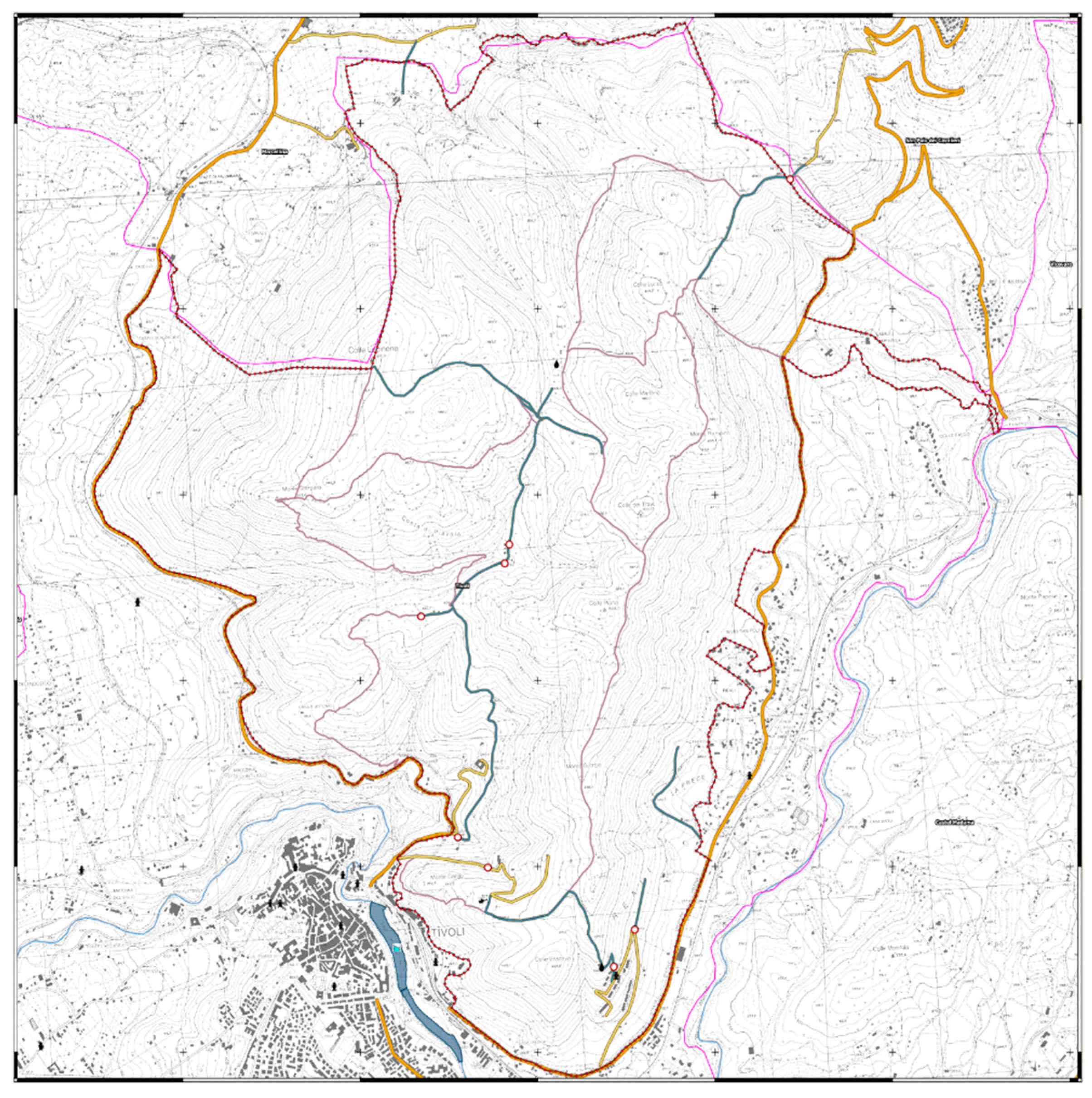
The Monte Catillo Nature Reserve covers its entire expanse of approximately 1320 hectares within the municipal territory of Tivoli in the Metropolitan City of Rome; it is located between the southern foothills of the Lucretili Mountains and the Roman countryside. It was established as a protected area by Regional Law No. 29 of 6 October 1997, titled ‘Provisions on regional protected natural areas’, with the aim of preserving the richness of the floral and vegetational heritage characterizing the area. The Reserve, named after Mount Catillo, as shown in Figure 2, which is located at an altitude of 348 m above sea level, features a landscape of hilly terrain, primarily limestone, populated by forests, shrublands, and pastures, with elevations ranging from 170 m to 612 m above sea level. It marks the boundary between the Apennine natural system and the Roman area, constituting the final Apennine fringe [40,41].
In Figure 3, Monte Catillo Nature Reserve is divided and classified into areas identified and regulated based on their respective levels of protection and specific use:
  • Integral Reserve Area (A)—Area A;
  • General Reserve Area (B)—Area B;
  • Protection Area (C)—Area C;
  • Economic-Social Promotion Area (ES-PZ)—Area D.
The Integral Reserve area (A) is identified and designated to protect and preserve nature and the environment completely. This zone includes areas characterized by particularly valuable vegetation, both for its rarity within the natural area and for its unique environmental or floristic characteristics, with the aim of preserving them from excessive human pressure. Therefore, all pastoral activities are prohibited in this zone, with exceptions made for research and study purposes, as well as for safeguarding public safety and preventing disasters and degradation phenomena. The General Reserve area (B) is identified with the purpose of safeguarding and protecting territories characterized by rich flora and high faunistic potential. Interventions here are directed, on a large scale, towards the conservation and protection of biodiversity, while not excluding compatible productive uses in pastoral and agritourism sectors. In this zone, which constitutes a significant part of the reserve’s territory, free access is allowed. Protection areas (C) are primarily used for agricultural or livestock activities. The purpose of this area is to promote, maintain, and facilitate, in symbiosis with the goals and objectives of the Reserve, forms of pastoral activity using traditional methods or according to methods of organic and/or eco-friendly agriculture compatible with the existing biotypes. This zone is mainly located in margin areas of the Nature Reserve that are already subject to significant human pressure and alteration. The Economic-Social Promotion area (D) identifies areas where initiatives and interventions aimed at the social and cultural improvement of local populations can be located. These areas are modified by historical and/or recent processes and include agricultural areas with scattered buildings or areas modified by settlement, residential, and productive phenomena.
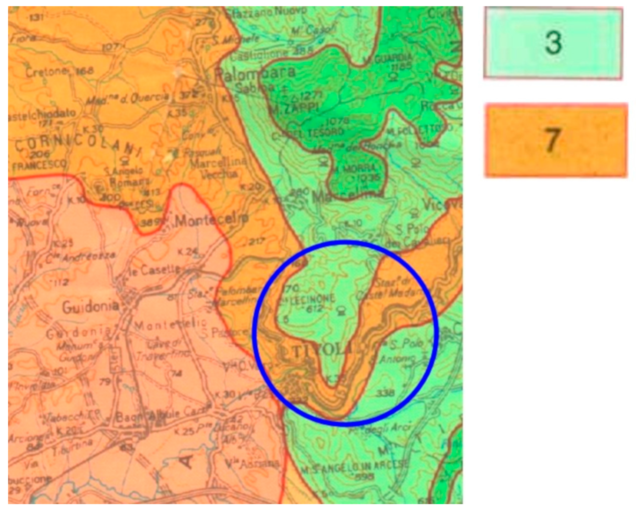
Referring to the phytoclimatic characterization carried out on a regional scale, the area under examination is mostly situated within the ‘temperate region’, corresponding to the climatic type of intramountain Apennine valleys [41].
It includes two phytoclimatic units, as shown in Figure 4:
  • Phytoclimatic unit no. 3 is characterized by rather high precipitation levels, ranging from 1161 to 1432 mm annually, and a slightly pronounced summer aridity, with average minimum temperatures fluctuating between −1.8 and 1.5 degrees Celsius, displaying characteristics of a cool and humid climate.
  • Phytoclimatic unit no. 7 is characterized by greater aridity and high precipitation values, ranging from 954 mm to 1166 mm. This does not compensate for the higher temperatures, characterized by average annual values exceeding 15 °C, contributing when a period of summer drought appears less than or equal to two months.
It is important to note that the orographic layout of the area, characterized by the presence of a ridge with a North-South alignment, results in a significant differentiation in the climatic and vegetational patterns between the western slopes and the eastern slopes. In fact, the central part and the north-facing exposure of the Reserve, corresponding to the summit portions, appear more pristine from a floristic and environmental perspective. The vegetation cover takes on more advanced forms, including tall forests in the innermost areas, even in the presence of cattle grazing, which also affects the forests within the Reserve. The situation is completely different for the south, east, and west exposures. These slopes exhibit formations of less value when compared to the previous ones, and are predominantly populated by shrublands and garigues, with sparser coverage and a mosaic structure due to the widespread impacts of human pressure, including free-range grazing, agriculture (mainly olive farming), and wildfires. The reserve, due to its location in a transitional bioclimatic, geomorphological, and environmental areas and varied botanical species. This is because it lies in a place of overlap and intersection between two different ecosystems, where ‘western’ species meet with thermophilic species, in addition to the abundant population of ‘eastern’ or ‘Balkan-eastern’ species.

2.3. Data Collection

As defined in the preceding paragraphs, the ignition points of wildfires occurring during the observation period are concentrated in areas dominated by:
  • Category A: Communities dominated by Ampelodesmos Mauritanicus;
  • Category B: Scrub vegetation and Eastern Sibljak.
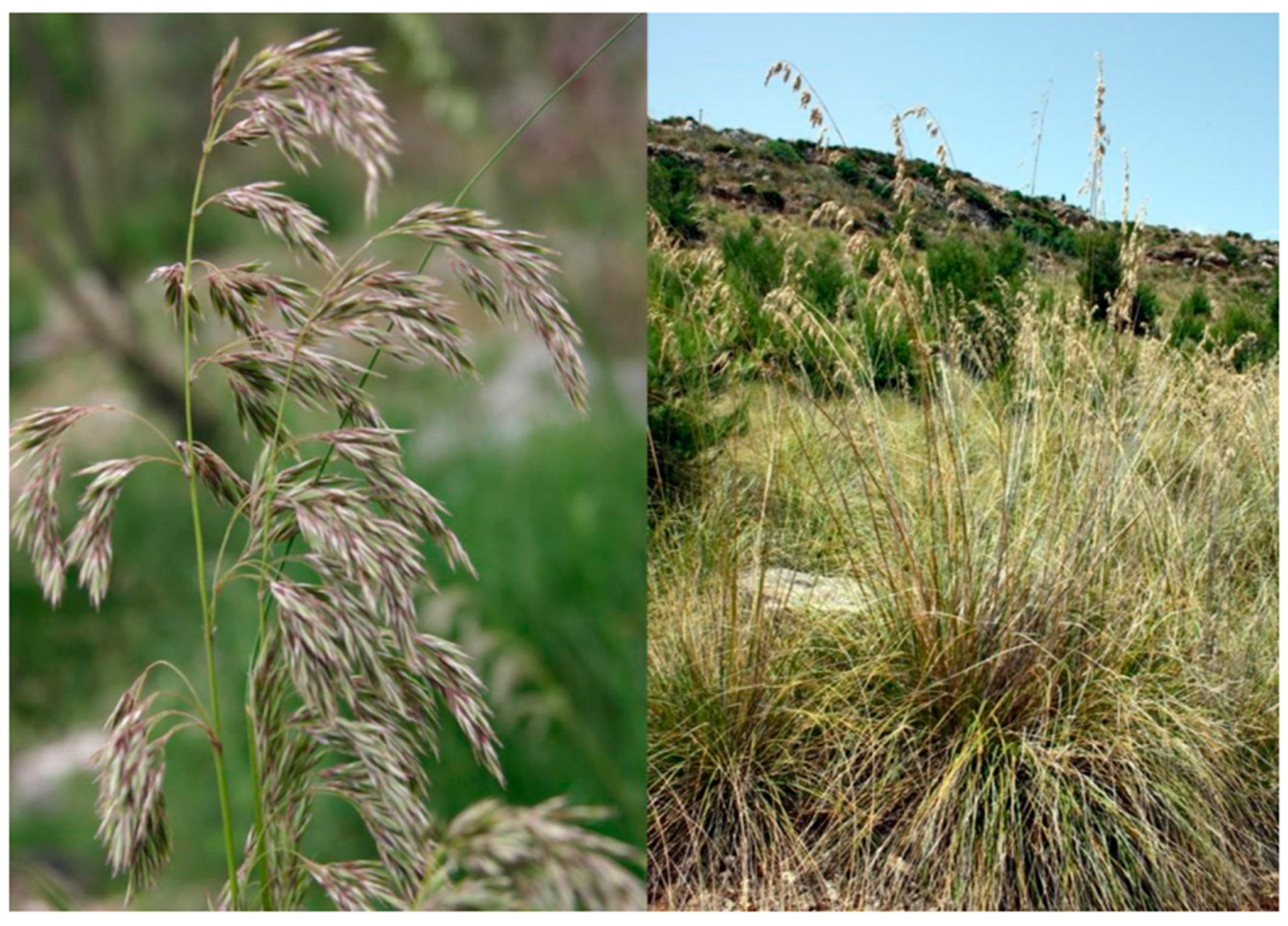
The community dominated by Ampelodesmos Mauritanicus is strongly present and widespread within the landscape of the Monte Catillo Nature Reserve, primarily in the southern part and on slopes exposed to direct solar radiation, covering an area of approximately 159 hectares. This species, commonly known as ‘Tagliamani’ is a visually striking and conspicuous grass with remarkable dimensions (up to 2 m); it is abundant in meadow areas, pastures, and shrub-covered areas of the Reserve.
It is also a species with a strictly Mediterranean distribution, with a southwestern center of gravity. Its flowering period occurs between April and June, releasing seeds and other primary dispersal units. Ampelodesmos Mauritanicus (Figure 5) is favored by the passage of fire, proving more competitive than many other species in recolonizing bare soil in the early post-fire phase when other plants are absent, thanks to its ability to rapidly resprout from the root system [42].
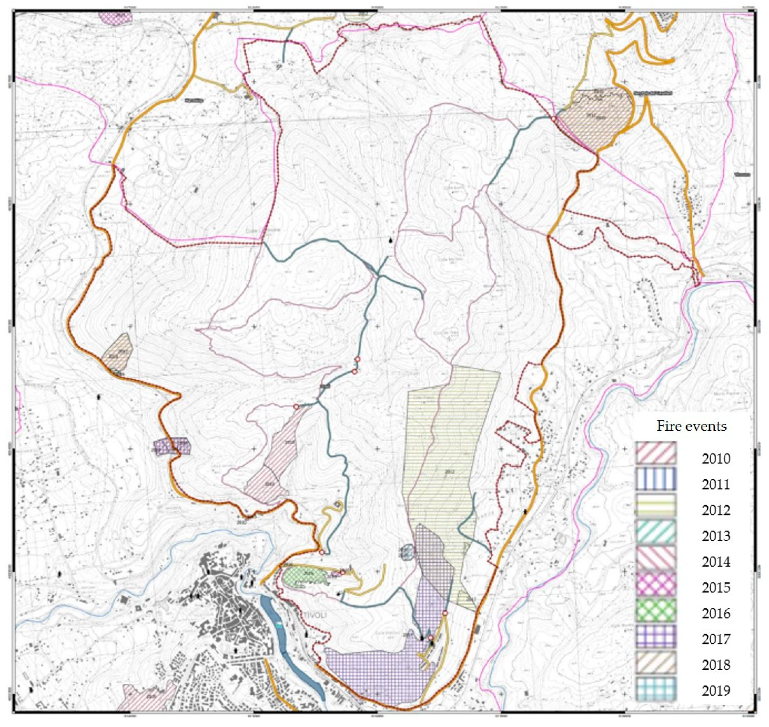
After characterizing the vegetation categories within the Monte Catillo Natural Reserve, we proceeded to analyze observed events and compile a registry of wildfires that have occurred over the past decade (Figure 6).
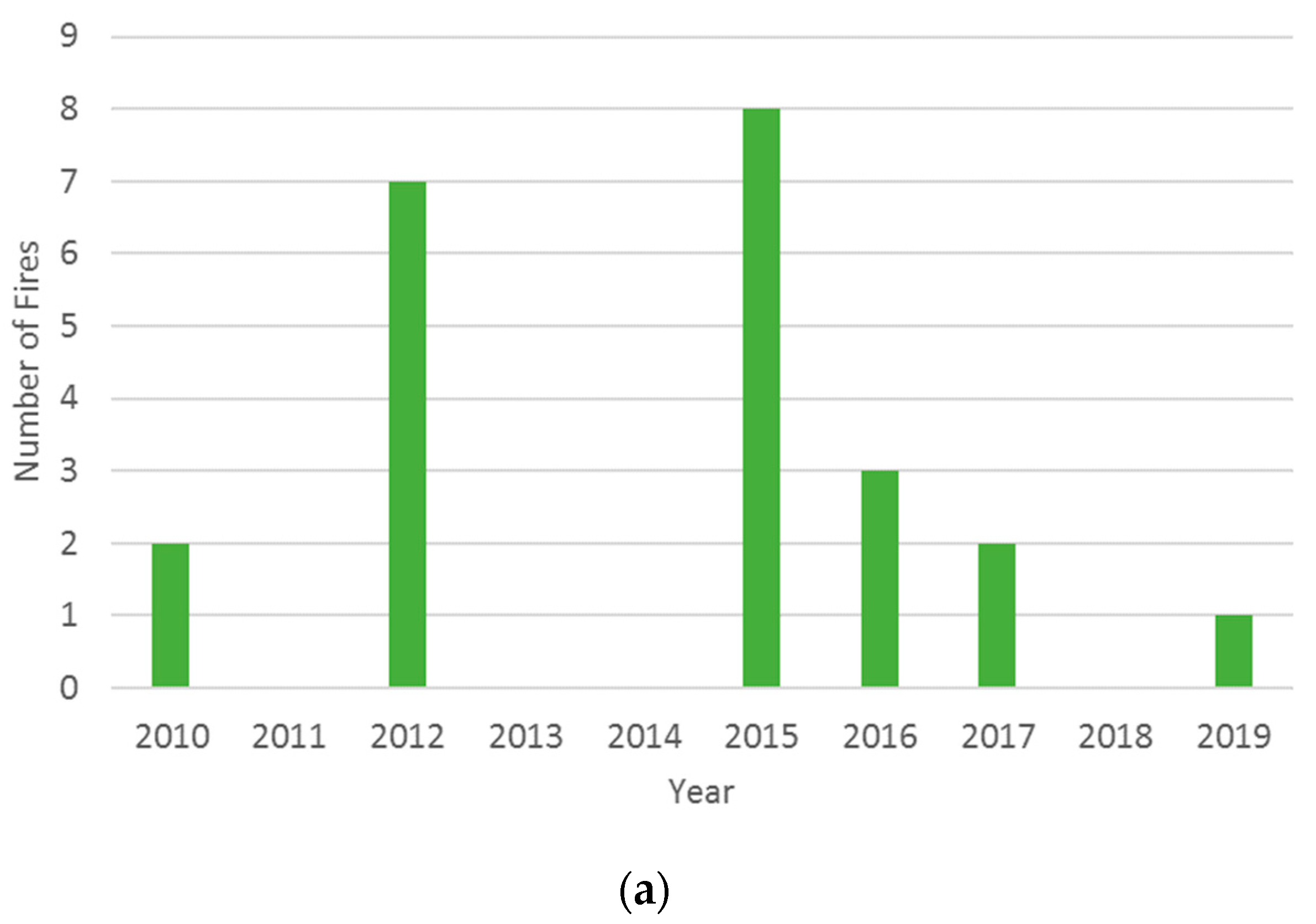
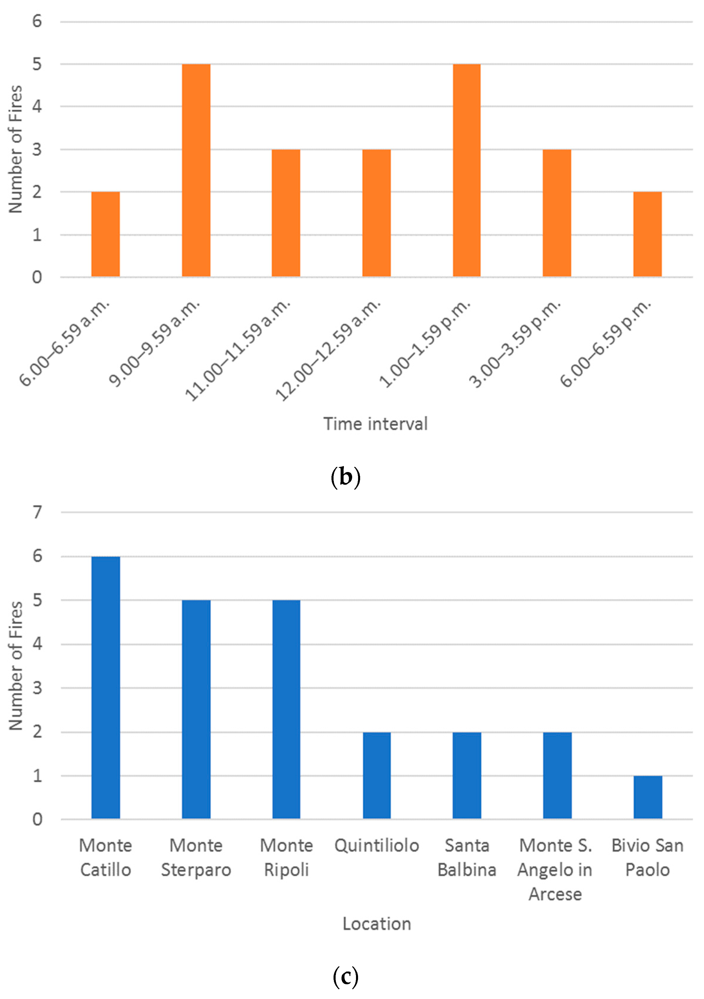
Following the analysis of wildfire trends in the study area, we present our findings. Figure 7a illustrates the number of fires over a ten-year period from 2010 to 2019. Figure 7b displays the frequency of wildfire occurrences within specific time intervals. Figure 7c shows the number of fires that occurred divided by the area of the Monte Catillo reserve.
Based on the theoretical analyses supported and observed in the preceding paragraphs of this chapter on the phenomenon of fire principles in the Monte Catillo Nature Reserve, it has been understood that events are strongly influenced by two factors:
  • the vegetational component affected at the time of ignition of the fire;
  • the coexistence and proximity of the SS5, SP31a, SC Don Nello del Raso, Hiking Network, and FL2 railway line.
For this reason, we chose to calculate the probability that events will not occur in the future or that one or more events will occur using the Poisson Probability Distribution [45]. To support this choice, the analysis cannot ignore the fact that a wildfire event is a primarily anthropogenic and unpredictable phenomenon that occurs more frequently near combustible vegetational areas. In fact, what happens is that when these areas are exposed to an ignition source, during the period between June 15th and August 31st, the event develops with great intensity right from the beginning. This is why a primarily anthropogenic wildfire phenomenon, while partially unpredictable and sudden, usually occurs with a certain regularity in the same areas.
The Poisson Probability Distribution is calculated based on the wildfire events reported in the twelve years of observation from the Fire Registry of the Nature Reserve. These events can be considered “statistically independent” and equiprobable, defining their average number in a specific time interval or in a specific area as constant. From the assumption of statistical independence, it follows that events that occurred in the past do not influence the following seasons:
  • the spatial location;
  • the timing of future fire occurrences.
The Poisson Distribution is used to calculate the probability of future occurrence of a number k of fire events in a time interval or area. This distribution is commonly used to describe the occurrence over time of events considered independent of each other and stationary in time with respect to those that occurred previously in the same area, and unable to influence the spatial location and timing of subsequent events.
The purpose of this work is to identify the probability of a specific fire occurring in an area and the local hazard of a particular fraction of the study area. The Poisson distribution and its process come with the following basic assumptions:
  • the probability of an event occurring is constant in all subintervals;
  • the event cannot occur more than once in each of the subintervals;
  • events in disjoint intervals are independent.

2.4. Methodology

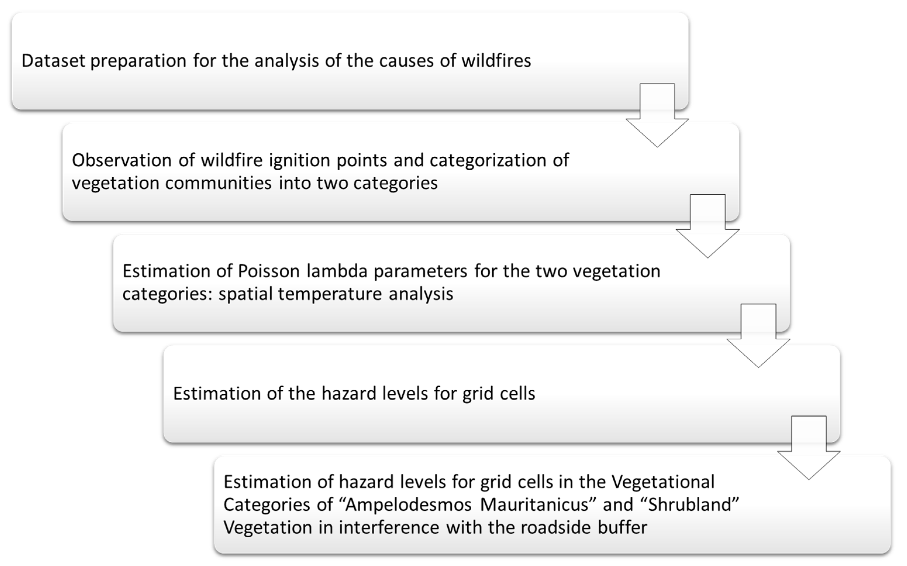
Figure 8 illustrates the fundamental steps employed to prepare the database and generate the hazard map for the Monte Catillo Natural Reserve study case. This flow represents the fundamental steps involved in creating the hazard map for the Monte Catillo Natural Reserve study. Each step is crucial for ensuring the accuracy and reliability of the final map.
The process of analysing the causes of wildfires began with meticulous dataset preparation, laying the foundation for a comprehensive study. Subsequently, we conducted a detailed observation of wildfire ignition points and meticulously categorized the diverse vegetation communities into two distinct categories. To better understand the fire dynamics, a spatial temperature analysis to estimate the Poisson lambda parameters for these two vegetation categories was conducted. The results allowed us to evaluate hazard levels across the grid cells, offering valuable insights into the areas at higher risk of wildfires. Additionally, we specifically focused on assessing the hazard levels in grid cells where “Ampelodesmos Mauritanicus” and Scrub Vegetation intersected with the roadside buffer, as this intersection posed unique challenges and necessitated a tailored approach to fire prevention and management.

2.5. Model Application

The first step of the database processing is the analysis of the causes of wildfires. The conducted study focused on wildfires that occurred in the Monte Catillo Nature Reserve during the observation period from 2010 to 2021. Wildfires within the Nature Reserve happen approximately every year, consuming and affecting several hectares of vegetation. The study area was divided into the following homogeneous zones based on vegetation characteristics, as reported in Table 1:
By interpolating the described maps, trigger points of wildfires were determined, utilizing the boundary of the Reserve as provided. In the examined territory, there were a total of 13 wildfires. Subsequently, further characterization was conducted to identify the specific vegetative species at the ignition points.
What emerges from the analysis can be summarized in two main considerations:
  • 7.7% of trigger points occurred in the presence of scrub vegetation.
  • 92.3% of trigger points occurred in areas dominated by Ampelodesmos Mauritanicus communities.
Subsequently, the next step, as shown in Table 2, was to assign to the fires their respective homogeneous vegetation zone and the corresponding percentage.
To understand the trigger point causes of the observed wildfires, considerations regarding their locations were taken into account. All fire incidents shared a common feature: their immediate proximity to roads, railways, and adjacent urbanized areas. On the northwest slope, a close connection was identified with Provincial Road SP31a, which connects the municipality of Tivoli to the municipality of Marcellina, the Rome-Sulmona-Pescara FL2 railway line, as well as Don Nello del Raso Municipal Road and the trail network of the Monte Catillo Nature Reserves.
What was observed on the eastern slope retains some similarities with the northern slope, with the exception that, in this case, the FL2 railway line deviates slightly from the perimeter boundaries of the Monte Catillo Nature Reserve, making it less influential in the ignition probability of the trigger points. However, the connection and direct interference with the SS5 national road, which connects the City of Rome to the City of Pescara, remains.
Wildfire data, associated with and influenced by communication routes, were further analyzed, seeking validation through GIS maps [46] and verifying any correlations. What has been highlighted is that the wildfire incidents fall into the following categories:
  • eastern Slope: 100% of wildfire incidents occur within privately owned areas within the boundaries of the Monte Catillo Nature Reserve.
  • northwest Slope: 64% of wildfire incidents occur within privately owned areas within the boundaries of the Monte Catillo Nature Reserve.
An additional consideration regarding the “Sterparo” and “Pineta Slope (Reserve)” wildfires is that, in the former case, the wildfire incidents occur in public areas within the perimeter of the Monte Catillo Nature Reserve and then spread into a polygon that extends into privately owned land [47]. A similar consideration can be made for the latter, where the wildfire incidents occur in a public area that borders privately owned areas to the east and west. The correlation drawn between public and private areas is linked to the fact that the latter were historically used for cultivation of Olea Europea Var. Sylvestrys, as well as vineyards and arable land. Currently, many of these plots are no longer used for agricultural activities and have fallen into a state of disuse, becoming covered by highly flammable vegetation, including scrub vegetation and communities dominated by Ampelodesmos Mauritanicus.
This additional data, when cross-referenced with the previous findings, confirm and supports the initial hypothesis that abandoned plots with uncontrolled vegetation substantially contribute to fire development. Therefore, it is evident that grazing, which could represent a preventive measure against trigger points, is distributed as follows in the 13 wildfires:
  • 84.6% of wildfire incidents occur in areas devoid of grazing within the boundaries of the Monte Catillo Nature Reserve.
  • 15.4% of wildfire incidents occur in areas with grazing within the boundaries of the Monte Catillo Nature Reserve.
In light of the observations mentioned earlier, the analysis aims to correlate the vegetational characteristics of the two analyzed categories (A and B) with the presence and interference of:
  • roadways
  • railroads
  • trail network
To achieve this, we followed the previously indicated process, which involved calculating two additional Lambda values:
  • λA,S for the Ampelodesmos Mauritanicus-dominated community correlated with infrastructure, categorized as A,S.
  • λB,S for the Shrubland Vegetation correlated with infrastructure, categorized as B,S.
Subsequently, within the GIS environment, a 200-m-wide roadside buffer was created, centered around:
  • on the East side, the Tiburtina Valeria State Road SS5;
  • on the North side, the SP31a Provincial Road.
Within the interior area, the Don Nello del Raso Municipal Road and the CAI 330 trail.
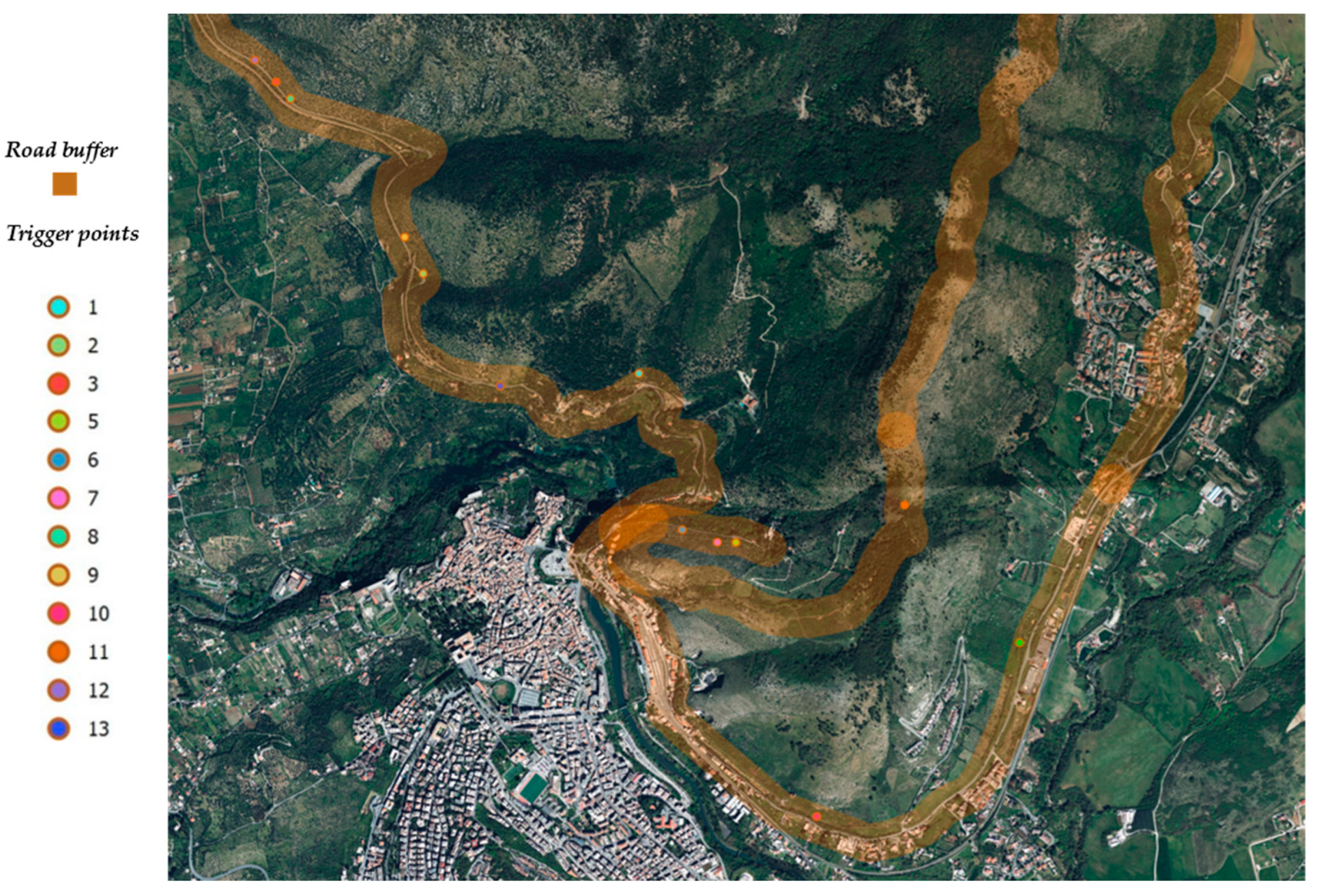
Observing Figure 9 below, it becomes evident that all trigger points occurring in geographic areas dominated by Ampelodesmos Mauritanicus communities fall within the Roadside Buffer. Consequently, all eleven previously observed events will be the subject of the second estimation.
Hazard Rate of Poisson, λA,S, which represents the average rate of Category A,S fire events within a specific temporal and spatial horizon, has been calculated using the following expression:
λ A , S = n o .   o f   f i r e   e v e n t s   i n   C a t e g o r y   A , S   a n d   o b s e r v a t i o n s = 11 12 = 0.9167
Meanwhile, in Figure 10, for the Scrub Vegetation, the only observed trigger point also falls within the Roadside Buffer.
Hazard Rate of Poisson, λB,S, representing the average rate of Category B fire events within a fixed temporal and spatial horizon, has been calculated using the following expression:
λ B , S = n o .   o f   f i r e   e v e n t s   i n   C a t e g o r y   B , S   a n d   o b s e r v a t i o n s = 1 12 = 0.0833
The next step is to observe the intervals with k = 0, 1, 2, …, n, where k is the number of events occurring in a year. This step allows us to calculate the frequencies of fires for both categories.
For Category A,S, representing the Ampelodesmos Mauritanicus-dominated community, the following observations are made (Figure 11):
f K = 0 , A , S   ( 2011 ,   2013 ,   2014 ,   2018 ,   2020 )   =   5 / 12 f K = 1 , A , S   ( 2012 ,   2015 ,   2017 ,   2019 )   =   4 / 12 f K = 2 , A , S   ( 2010 ,   2021 )   =   2 / 12 f K = 3 , A , S   ( 2016 )   =   1 / 12
The Category B, referring to scrub vegetation, exhibits the following observations (Figure 12):
f K = 0 , B , S   ( 2010 ,   2011 ,   2013 ,   2014 ,   2015 ,   2016 ,   2017 ,   2018 ,   2019 ,   2020 ,   2021 )   =   11 / 12 f K = 1 , B , S   ( 2012 )   =   1 / 12
After observing the data and calculating the frequencies, validation is performed using the chi-square test by applying the formula [48]. The test results for Category Vegetation A,S are sequentially presented in the Table 3 below. The value of χ2 is 8.8702 which, considering the tolerated error of 5%, when compared with the chi-square distribution tables with four degrees of freedom (as there are five frequency classes corresponding to five degrees of freedom, subtracting one degree of freedom due to the use of the total number of values to calculate individual events), allows us to accept the null hypothesis with test statistic value lower than 9.488.
In Table 4, there is the calculation and verification of the statistical representativeness of the Poisson λB,S distribution coefficient. The value of χ2 is 0.0263, which, considering the tolerated error of 5%, when compared with the chi-square distribution tables with two degrees of freedom (as there are three frequency classes corresponding to three degrees of freedom, subtracting one degree of freedom due to the use of the total number of values to calculate individual events), allows us to accept the null hypothesis with test statistic value lower than 5.991.

3. Results

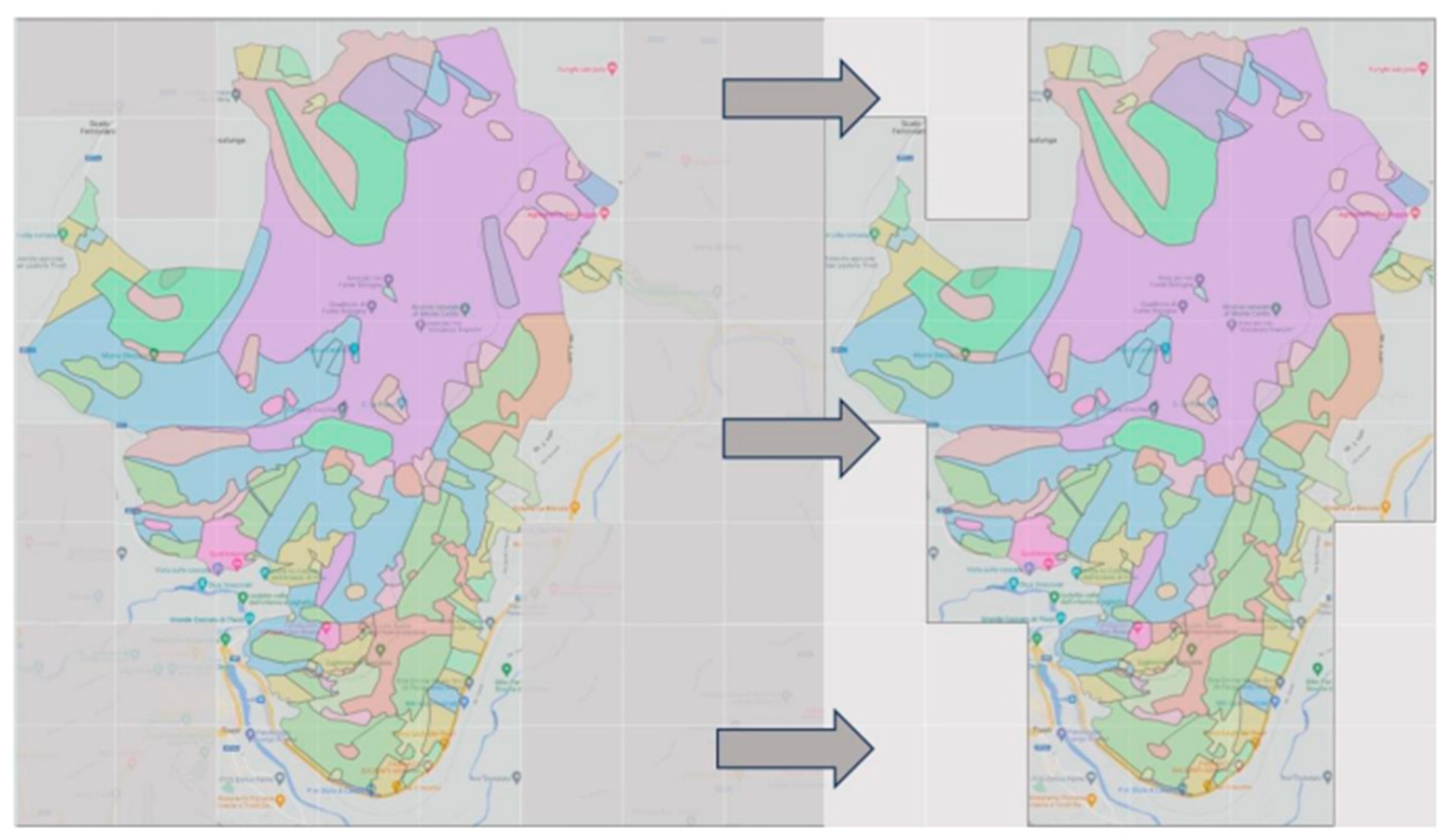
In the Figure 13, in order to estimate the danger of fire categories in the Monte Catillo Natural Reserve, the entire territory has been divided into a grid of 64 square cells, each measuring 1000 m × 1000 m. Out of the proposed cells, only 56.3% covered all or part of the Monte Catillo Natural Reserve area, transitioning from the left configuration to the right configuration.
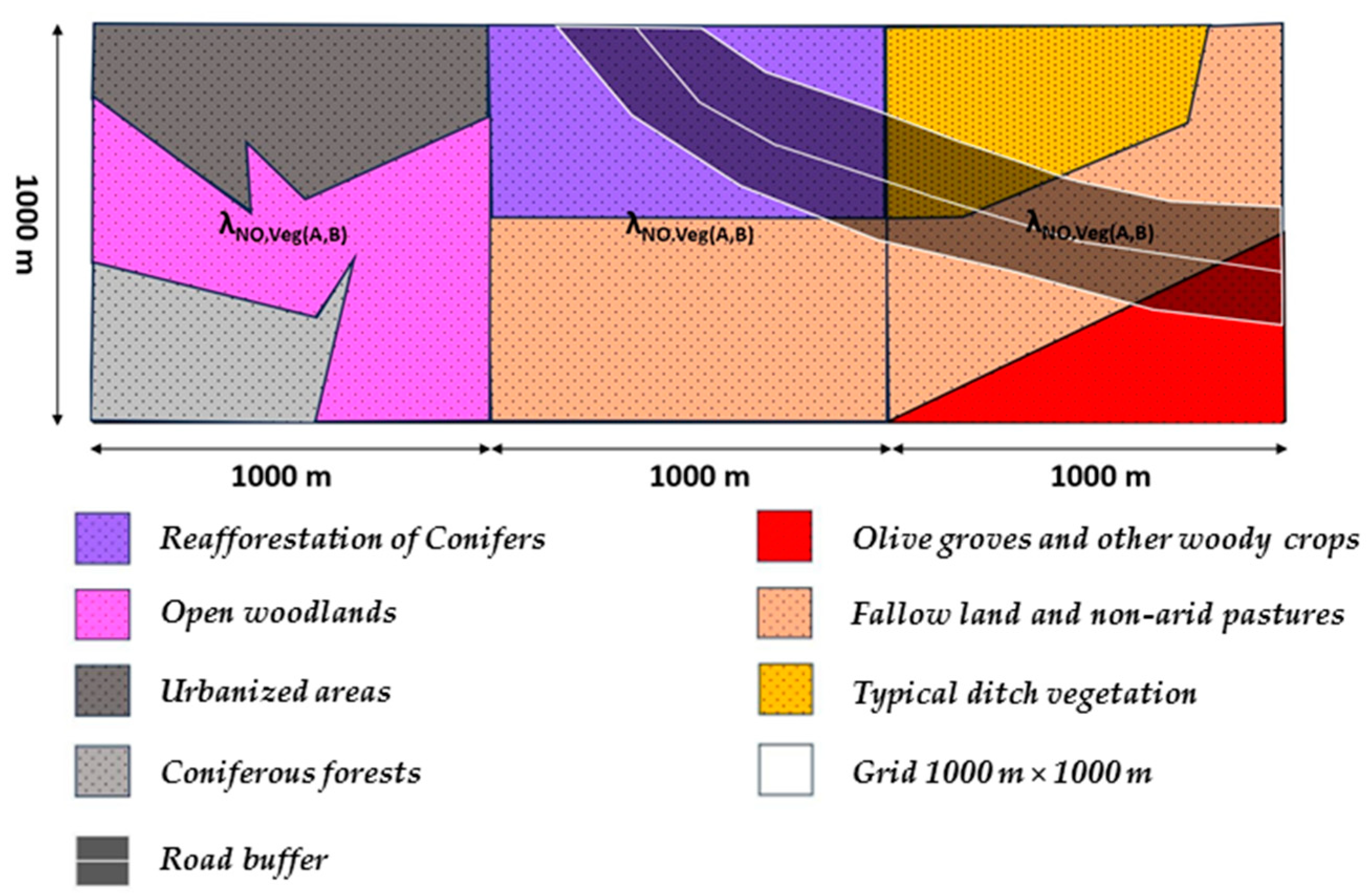
The first analysis, in Figure 14, is about all categories with vegetation species not belonging to Categories A and B within the grid cells. It also includes the intersection of the road buffer, which predominantly occurs along the San Paolo Road (East Slope) within the Natural Reserve.
Of these, a near-zero ignition probability was a priori assumed, based on the fire registry data; it was verified that trigger events for these vegetation types have never been observed, even in proximity to road buffers. Therefore, PCZ (t) is approximately zero.
The second analysis concerns Vegetation Categories A and B within the boundaries of the Monte Catillo Natural Reserve. In this distinction, only those grid cells within the reserve boundaries without the presence of road buffers, as depicted in the image, are taken into consideration, as show in Figure 15.
In this section, the ignition probability for fires has been assumed to be close to zero, based on the fire registry data, and it has been verified that trigger events for these vegetation types only occurred in conjunction with road buffers. Therefore, PA,B (t) is considered to be approximately zero.
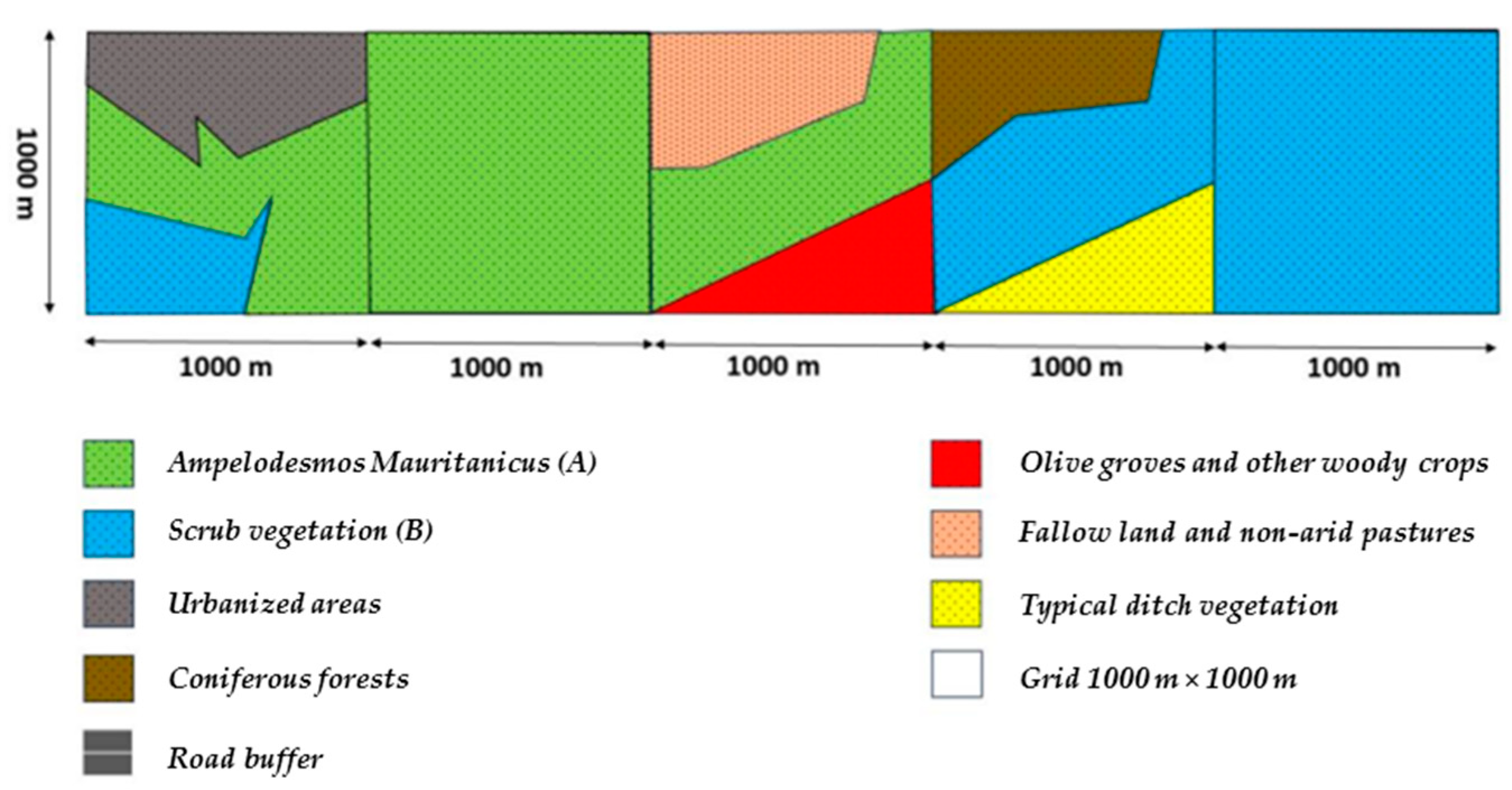
The third analysis pertains to Vegetation Categories A and B within the boundaries of the Monte Catillo Natural Reserve. In this distinction, only those grid cells within the reserve boundaries with the presence of road buffers, as depicted in the image, are taken into consideration, as in Figure 16.
Therefore, for this section of analysis, the probabilities and return times have been calculated, respectively, for Category A and B in the road buffer intersection, representing the likelihood that one or more fire incidents will occur in a seasonal year within the Monte Catillo Natural Reserve area:
P A , S   ( K > 0 )   =   1 P A , S   ( 0 )   =   0.6002 P B , S   ( K > 0 )   =   1 P B , S   ( 0 )   =   0.0800 t R ; A , S   =   P A , S   ( K > 0 )   =   1.7   [ years ] t R ; B , S   =   P B , S   ( K > 0 )   =   12.5   [ years ]
where k indicates the number of fire incidents.
At the end of the procedure, the study involves the GIS analysis of the intersection of three layers, as show in Figure 17:
  • road buffer and road lines;
  • 1000 m × 1000 m grid;
  • Scrub vegetation and community dominated by Ampelodesmos Mauritanicus.
Through this process, the following data, shown in Figure 18, have been extracted for each individual cell and the total sum across the fifteen study cells:
-
area of Vegetation Category A overlapping with road buffer [m2];
-
area of Vegetation Category B overlapping with road buffer [m2];
-
total Area of Vegetation Category A overlapping with road buffers in the fifteen considered cells [m2];
-
total Area of Vegetation Category B overlapping with road buffers in the fifteen considered cells [m2].
Considering the probabilities calculated in the previous section, we have arrived at the determination of the probability of fires in the critical areas of the Natural Reserve, identified as the cells that intersect with the road buffer, using the following equation:
P C e l l k > 0 = A r e a A , S A r e a T ; A , S · 1 P A , S 0 + A r e a B , S A r e a T ; B , S · 1 P B , S 0
The results of the calculation of probability for cells within the grid with the presence of Vegetation Categories A and B in conjunction with the road buffer are presented in the following Table 5.
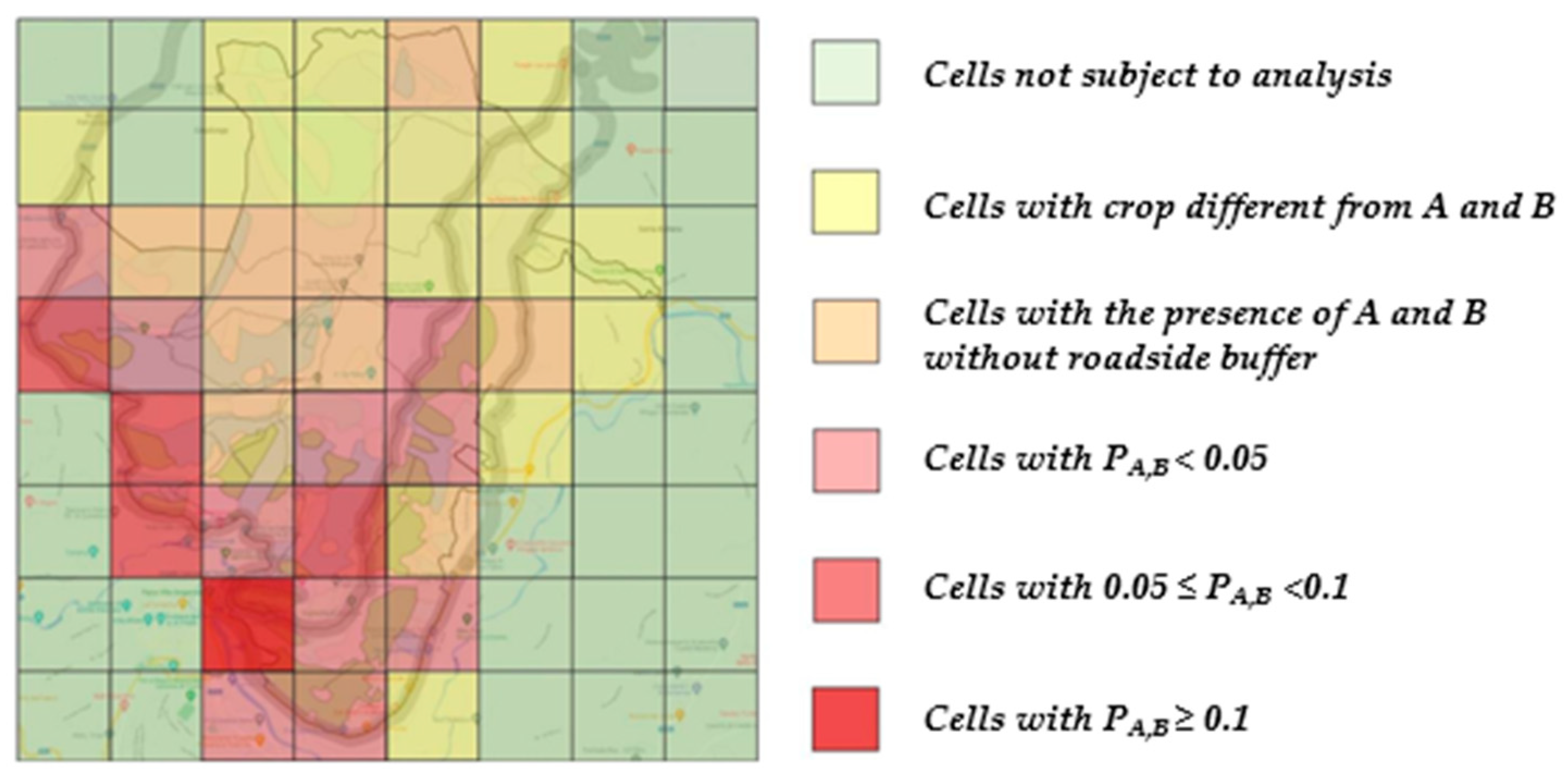
The fire hazard map of the Monte Catillo Natural Reserve allows for the identification of the risk of forest fires for each individual cell under consideration.
Colours have a meaning associated with probability calculation in the study area. Green cells represent areas not subject to analysis. Cells with a yellow colour indicate areas with different crops than categories A and B. Orange-coloured cells are those that do not interfere with the roadside buffer. Finally, three different shades of red are used in the figure to represent cells with probabilities less than 0.05, between 0.05 and 0.1, and greater than 0.1, as reported in Figure 19.

4. Discussion

Vegetation is considered as a complex system in constant transformation due to both seasonal variations and the development of individual entities and populations, following a directional trend that results in substantial changes in plant communities, known as the process of succession. The concept of succession is a continuous process from pioneer vegetation to climax, occurring through temporary stages, until reaching the stage of final stability that persists for extended periods [49]. It is important to specify that there are also disclimax plant communities, referring to landscapes that fail to reach the final stage due to periodic destruction or disturbances, as is the case with the Monte Catillo Nature Reserve, which annually experiences wildfires during the summer period, primarily on the southern side of the area. Disturbances are defined as discrete events in time that have the property of damaging the ecosystem or removing phytomass, altering the structure of pant populations, including:
  • fires;
  • storms;
  • floods;
  • earthquakes;
  • volcanic eruptions;
  • insect invasions.
For successions, a distinction can be made based on the starting environments and early stages, differentiating into:
  • primary succession, where the establishment and development of the community occur in environments devoid of vegetation, typically involving areas never colonized previously.
  • secondary succession, where the process begins with a disturbance event that reduces a pre-existing ecosystem in terms of the number of individuals.
In the present case, the disturbance under consideration is fire, viewed as a typical process in terrestrial ecosystems. This can be understood as a vision of fire as a destructive and irreversible force but also as a fundamental and intrinsic process of ecosystems. In fact, the onset of human activities in the Mediterranean basin, coinciding with the exponential increase in wildfires, leads to the assertion that the prevailing vegetational formations have transformed, evolved, and adapted over the past ten thousand years. The potential natural vegetation in a Mediterranean-type climate would predominantly consist of evergreen sclerophyllous forests and, under milder conditions, deciduous forests. This, however, is contradicted by the presence of formations such as shrubland and garigue, representing vegetational types adapted to different fire regimes.
The two types of adaptation characterizing the Monte Catillo Nature Reserve can be summarized as:
  • resprouting (the ability to resprout), i.e., the regenerative capacity of plants following fires, activating dormant shoots that can be located at the base of the trunk or underground structures.
  • fire resistance, i.e., the plant’s ability to defend itself from fires through external structures such as bark thickness and suberification (cork formation).
It is also important to understand the effect of fire as a correlation of both disturbance magnitude, understood as the dimensional characteristics of the area affected by fire, and its intensity, dynamics, and propagation mode. What happens is that areas with dense and continuous vegetation cover, when hit by fire, undergo a significant reduction in the species that composed the phytocoenosis, leading to landscape fragmentation and heterogeneity, which, in turn, increases the frequency of fires. Conversely, when fire predominantly affects shrublands, it causes a decrease in fragmentation and homogenization of the landscape, promoting a heterogeneous system in which vegetation is maintained in dynamic balance between different stages of regeneration and degradation. The impact of historical fires on future fire occurrences in each area is a significant concern, primarily attributed to the concept of fuel consumption. This idea finds partial support in the case study area’s observational fire data. In fact, the intricate relationship between past fire events, fuel availability, and the likelihood of future fires, highlighting the importance of understanding and managing these factors for effective fire prevention and mitigation strategies. Although these transformations are substantial, they can still contribute to enriching the landscape by increasing its ecological complexity, which occurs in the study area of the Monte Catillo Nature Reserve.
Furthermore, the present vegetational species have the ability to regenerate quickly after the passage of fire. This regeneration can occur through two modalities:
  • through seeds in the soil or through seeds that can reach the burned area, essential for many herbaceous species and especially for annual species characterizing both the “Arid Meadows of Central-Southern Apennines” and the “Arid Meadows of Western Mediterranean”.
  • through the resumption of individuals that have maintained vital buds despite the passage of fire, capable of rapidly regenerating photosynthetic tissue (this is the most common recovery strategy for the vegetation populations present in the Reserve).
Regarding the analysis conducted through geostatistical modeling and the chi-square test, it is important to acknowledge certain limitations inherent to this study. One notable limitation is the restricted applicability of the model, which was exclusively tested within the context of this specific case study. In this case study, there is the situation where the major categories of dominated vegetation were limited to just two. The geostatistical model’s effectiveness and the chi-square test’s validity may not hold up as well when applied to diverse ecological or geographical settings with more complex vegetation categories.

5. Conclusions

The fire hazard map of the Monte Catillo Natural Reserve allows for the identification of wildfire risk for each individual cell considered. The initial observation is that it aligns, on a large scale, with the considerations made in the previous chapters. Specifically, cells with higher local hazard are those located near the roadside buffer and exhibit vegetation communities falling under Categories A and B during ignition.
The hazard map can serve as a useful tool for carrying out prevention and protection measures. In terms of prevention, it could guide the managers of the Monte Catillo Natural Reserve to:
  • identify mowing operations and the creation of firebreaks in cells where there is interference between the roadside buffer and Vegetation Categories A and B.
  • install surveillance devices and conduct patrol actions that, through deterrence, contribute to reducing the probability of forest fire ignition.
As part of protection measures, the hazard map can be valuable to:
  • concentrate terrestrial firefighting resources near cells at higher risk of ignition and install tanks and containers with extinguishing materials along the roadside interfering with the CAI 330 trail.
  • develop evacuation plans for residents in urbanized areas within the grids at higher risk.
  • establish direct communication with RFI and road management authorities mentioned to prevent interference with road users in the event of a forest fire.
Some limitations need to be highlighted. Thanks to the limited dataset, obviously the Poisson model and the chi-square test need to be improved. Incorporating additional variables into the model may enhance its predictive power and expand its utility. This is especially relevant for improving the model’s performance beyond the limitations inherent to a single case study. To enhance the robustness and applicability of our findings, future research should aim to replicate and extend this study across a wider range of scenarios. This would help validate the model’s performance in various environments and provide a more comprehensive understanding of its strengths and weaknesses. Additionally, considering alternative statistical methods or incorporating additional variables may improve the model’s accuracy and expand its utility beyond the constraints of this singular case study.

Author Contributions

Conceptualization, D.B., M.G., A.L. and M.L.; methodology, D.B., M.L. and A.L.; validation, D.B. and M.L; writing, review, and editing, D.B., M.G. and M.L. All authors have read and agreed to the published version of the manuscript.

Funding

This research received no external funding.

Institutional Review Board Statement

Not applicable.

Informed Consent Statement

Not applicable.

Data Availability Statement

Not applicable.

Acknowledgments

This study was carried out within the RETURN Extended Partnership and received funding from the European Union Next-GenerationEU (National Recovery and Resilience Plan—NRRP, Mission 4, Component 2, Investment 1.3–D.D. 1243 2/8/2022, PE0000005). This study was conducted thanks to the collaboration and data provide by the Metropolitan City of Rome Capital—Department III—Protected Areas Service—Biodiversity Conservation for the master’s thesis project of the student Matteo Cacioni.

Conflicts of Interest

The authors declare no conflict of interest.

References

  1. Wasserman, T.N.; Mueller, S.E. Climate influences on future fire severity: A synthesis of climate-fire interactions and impacts on fire regimes, high-severity fire, and forests in the western United States. Fire Ecol. 2023, 19, 43. [Google Scholar] [CrossRef]
  2. Hillayová, M.K.; Holécy, J.; Korísteková, K.; Bakšová, M.; Ostrihoň, M.; Škvarenina, J. Ongoing climatic change increases the risk of wildfires. Case study: Carpathian spruce forests. J. Environ. Manag. 2023, 337, 117620. [Google Scholar] [CrossRef] [PubMed]
  3. Woo, S.H.L.; Liu, J.C.; Yue, X.; Mickley, L.J.; Bell, M.L. Air pollution from wildfires and human health vulnerability in Alaskan communities under climate change. Environ. Res. Lett. 2020, 15, 9. [Google Scholar] [CrossRef] [PubMed]
  4. Vicente-Serrano, S.M.; Quiring, S.M.; Peña-Gallardo, M.; Shanshui, Y.; Domínguez-Castro, F. A review of environmental droughts: Increased risk under global warming? Earth-Sci. Rev. 2019, 201, 102953. [Google Scholar] [CrossRef]
  5. Molitor, D.; Mullins, J.T.; White, C. Air pollution and suicide in rural and urban America: Evidence from wildfire smoke. Proc. Natl. Acad. Sci. USA 2023, 120, e2221621120. [Google Scholar] [CrossRef] [PubMed]
  6. Halofsky, J.E.; Peterson, D.L.; Harvey, B.J. Changing wildfire, changing forests: The effects of climate change on fire regimes and vegetation in the Pacific Northwest, USA. Fire Ecol. 2020, 16, 4. [Google Scholar] [CrossRef]
  7. Bowman, D.M.J.S.; Sharples, J.J. Taming the flame, from local to global extreme wildfires. Science 2023, 381, 616–619. [Google Scholar] [CrossRef]
  8. Mercer, D.E.; Prestemon, J.P. Comparing production function models for wildfire risk analysis in the wildland–urban interface. For. Policy Econ. 2005, 7, 782–795. [Google Scholar] [CrossRef]
  9. Balch, J.K.B.; Bethany, A.; Abatzoglou, J.T.N.; Fusco, R.C.; Mahood, E.J.; Adam, L. Human-started wildfires expand the fire niche across the United States. Proc. Natl. Acad. Sci. USA 2007, 2946, 114. [Google Scholar] [CrossRef]
  10. Poktonic, I. Geographical Aspect Of Rural Areas: Transformation In Slovenia. Bull. Soc. Géogr. Liège 2001, 41, 69–76. [Google Scholar]
  11. Karlis, D.; Ntzoufras, I. Analysis of sports data by using bivariate Poisson models. J. R. Stat. Soc. Ser. D (Stat.) 2003, 52, 381–393. [Google Scholar] [CrossRef]
  12. Waeselynck, V.; Johnson, G.; Schmidt, D.; Moritz, M.A.; Saah, D. Quantifying the sampling error on burn counts in Monte-Carlo wildfire simulations using Poisson and Gamma distributions. Res. Sq. 2023. preprint. [Google Scholar] [CrossRef]
  13. Eriksson, C.P.; Johansson, N.; McNamee, M. The performance of wildfire danger indices: A Swedish case study. Saf. Sci. 2023, 159, 106038. [Google Scholar] [CrossRef]
  14. Thangavel, K.; Spiller, D.; Sabatini, R.; Amici, S.; Sasidharan, S.T.; Fayek, H.; Marzocca, P. Autonomous Satellite Wildfire Detection Using Hyperspectral Imagery and Neural Networks: A Case Study on Australian Wildfire. Remote Sens. 2023, 15, 720. [Google Scholar] [CrossRef]
  15. Trucchia, A.; D’Andrea, M.; Baghino, F.; Fiorucci, P.; Ferraris, L.; Negro, D.; Gollini, A.; Severino, M. PROPAGATOR: An Operational Cellular-Automata Based Wildfire Simulator. Fire 2020, 3, 26. [Google Scholar] [CrossRef]
  16. Iban, M.C.; Sekertekin, A. Machine learning based wildfire susceptibility mapping using remotely sensed fire data and GIS: A case study of Adana and Mersin provinces, Turkey. Ecol. Inform. 2022, 69, 101647. [Google Scholar] [CrossRef]
  17. Di Napoli, M.; Marsiglia, P.; Di Martire, D.; Ramondini, M.; Ullo, S.L.; Calcaterra, D. Landslide Susceptibility Assessment of Wildfire Burnt Areas through Earth-Observation Techniques and a Machine Learning-Based Approach. Remote Sens. 2020, 12, 2505. [Google Scholar] [CrossRef]
  18. Trucchia, A.; Meschi, G.; Fiorucci, P.; Gollini, A.; Negro, D. Defining Wildfire Susceptibility Maps in Italy for Understanding Seasonal Wildfire Regimes at the National Level. Fire 2022, 5, 30. [Google Scholar] [CrossRef]
  19. Akay, A.E.; Şahin, H. Forest Fire Risk Mapping by using GIS Techniques and AHP Method: A Case Study in Bodrum (Turkey). Eur. J. For. Eng. 2019, 5, 25–35. [Google Scholar] [CrossRef]
  20. Coban, O.; Erdin, C. Forest Fire Risk Assessment Using Gis and AHP Integration In Bucak Forest Enterprise, Turkey. Appl. Ecol. Environ. Res. 2020, 18, 1567–1583. [Google Scholar] [CrossRef]
  21. Gheshlaghi, H.A.; Feizizadeh, B.; Blaschke, T. GIS-based forest fire risk mapping using the analytical network process and fuzzy logic. J. Environ. Plan. Manag. 2020, 63, 481–499. [Google Scholar] [CrossRef]
  22. Faramarzi, H.; Hosseini, S.M.; Pourghasemi, H.R.; Farnaghi, M. Forest fire spatial modelling using ordered weighted averaging multi-criteria evaluation. J. For. Sci. 2021, 67, 87–100. [Google Scholar] [CrossRef]
  23. Novkovic, I.; Markovic, G.B.; Lukic, D.; Dragicevic, S.; Milosevic, M.; Djurdjic, S.; Samardzic, I.; Lezaic, T.; Tadic, M. GIS-Based Forest Fire Susceptibility Zonation with IoT Sensor Network Support, Case Study—Nature Park Golija, Serbia. Sensors 2021, 21, 6520. [Google Scholar] [CrossRef] [PubMed]
  24. Guo, F.T.; Su, Z.; Wang, G.; Sun, L.; Lin, F.; Liu, A. Wildfire ignition in the forests of southeast China: Identifying drivers and spatial distribution to predict wildfire likelihood. Appl. Geogr. 2016, 66, 12–21. [Google Scholar] [CrossRef]
  25. Jaafari, A.; Mafi-Gholami, D.; Thai Pham, B.; Tien Bui, D. Wildfire Probability Mapping: Bivariate vs. Multivariate Statistics. Remote Sens. 2019, 11, 618. [Google Scholar] [CrossRef]
  26. Arca, D.; Hacısalihoğlu, M.; Kutoğlu, S.H. Producing Forest fire susceptibility map via multi-criteria decision analysis and frequency ratio methods. Nat. Hazards J. Int. Soc. Prev. Mitig. Nat. Hazards 2020, 104, 73–89. [Google Scholar] [CrossRef]
  27. Al-Bashiti, M.K.; Naser, M.Z. Machine learning for wildfire classification: Exploring blackbox, explainable, symbolic, and SMOTE methods. Nat. Hazards Res. 2022, 2, 145–165. [Google Scholar] [CrossRef]
  28. Zhang, G.; Wang, M.; Liu, K. Deep neural networks for global wildfire susceptibility modelling. Ecol. Indic. 2021, 127, 107735. [Google Scholar] [CrossRef]
  29. Akıncı, H.A.; Akıncı, H. Machine learning based forest fire susceptibility assessment of Manavgat district (Antalya), Turkey. Earth Sci. Inform. 2023, 16, 397–414. [Google Scholar] [CrossRef]
  30. Tonini, M.; D’Andrea, M.; Biondi, G.; Degli Esposti, S.; Trucchia, A.; Fiorucci, P. A machine learning-based approach for mapping susceptibility to fire. The Case Study of the Liguria Region in Italy. Geosciences 2020, 10, 105. [Google Scholar] [CrossRef]
  31. Littell, J.; Peterson, D.; Riley, K.; Liu, Y.; Luce, C. A review of the relationships between drought and forest fire in the United States. Glob. Chang. Biol. 2016, 22, 2353–2369. [Google Scholar] [CrossRef] [PubMed]
  32. Anderegg, W.; Flint, A.; Huang, C.; Flint, L.; Berry, J.A.; Davis, F.W.; Sperry, J.S.; Field, C.B. Tree mortality predicted from drought-induced vascular damage. Nat. Geosci. 2015, 8, 367–371. [Google Scholar] [CrossRef]
  33. Piao, Y.; Lee, D.K.; Park, S.J.; Kim, H.; Jin, Y. Multi-hazard mapping of droughts and forest fires using a multi-layer hazards approach with machine learning algorithms. Geomatics. Nat. Hazards Risk 2022, 13, 2649–2673. [Google Scholar] [CrossRef]
  34. Catchpole, W.; Bradstock, R.; Choate, J.; Fogarty, L.; Gellie, N.; McCarthy, G.; McCaw, W.; Marsden-Smedley, J.; Pearce, G. Cooperative development of equations for heathland fire behaviour. In Proceedings of the 3rd International Conference of Forest Fire Research, Luso, Portogallo, 16–20 November 1998. [Google Scholar]
  35. Keeley, J.; Safford, H.; Fotheringham, C.; Franklin, J.; Moritz, M. The 2007 Southern California Wildfires: Lessons in Complexity. J. For. 2009, 107, 287–296. [Google Scholar]
  36. Graham, R.; Mccaffrey, S.; Jain, T. Science Basis for Changing Forest Structure to Modify Wildfire Behavior and Severity; The Bark Beetles, Fuels, and Fire Bibliography; U.S. Department of Agriculture, Forest Service, Rocky Mountain Research Station: Fort Collins, CO, USA, 2004.
  37. Ferrer Palomino, A.; Sánchez Espino, P.; Borrego Reyes, C.; Rojas, J.A.J.; Rodríguez Silva, F. Estimation of moisture in live fuels in the mediterranean: Linear regressions and random forests. J. Environ. Manag. 2022, 322, 116069. [Google Scholar] [CrossRef] [PubMed]
  38. Dasgupta, S.; Qu, J.; Hao, X. Design of a Susceptibility Index for Fire Risk Monitoring. IEEE Geosci. Remote Sens. Lett. 2006, 3, 140–144. [Google Scholar] [CrossRef]
  39. Law No. 353 of 21 November 2000, Framework Law on Forest Fires. Available online: https://www.fao.org/faolex/results/details/en/c/LEX-FAOC031085/ (accessed on 1 July 2023).
  40. The Management Plan for the Monte Catillo Nature Reserve, Approved by the Commissioner ad Acta on 26 November 2015, and Published in the Official Regional Bulletin (BURL) on 19 January 2016, No. 5, Supplement No. 2. Available online: https://www.cittametropolitanaroma.it (accessed on 1 July 2023).
  41. Regional Law of 6 October 1997, No. 29, Chapter I, ‘General Provisions and Procedures for the Identification and Establishment of Protected Natural Areas, Natural Monuments, and Sites of Community Importance’.
  42. Burrascano, S.; Caucci, L.; Ferrante, G. Vegetation Studies in the Monte Catillo Nature Reserve; Department of Environmental Biology, La Sapienza University of Rome: Rome, Italy, 2022. [Google Scholar]
  43. Vegetational Appearance of the Ampelodesmos Mauritanicus Species. Available online: https://dryades.units.it (accessed on 1 July 2023).
  44. Città Metropolitana di Roma Capitale, Piano AIB per la Programmazione delle Attività di Previsione, Prevenzione e Lotta Attiva contro gli Incendi Boschivi nei Parchi e nelle Riserve Naturali Regionali, Periodo di validità 2020–2024, Riserva Naturale di Monte Catillo: Tivoli, Italy, 2020.
  45. Li, C.S.; Lu, J.C.; Park, J.; Kim, K.; Brinkley, P.A.; Peterson, J.P. Multivariate Zero-Inflated Poisson Models and Their Applications. Technometrics 1999, 41, 29–38. [Google Scholar] [CrossRef]
  46. Zaki, A.; Buchori, I.; Sejati, A.W.; Liu, Y. An object-based image analysis in QGIS for image classification and assessment of coastal spatial planning. Egypt. J. Remote Sens. Space Sci. 2022, 25, 349–359. [Google Scholar] [CrossRef]
  47. Land Use. Available online: https://www.cittametropolitanaroma.it/homepage/aree-tematiche/ambiente/aree-protette-tutela-della-flora-della-biodiversita/le-aree-protette-della-citta-metropolitana-roma-capitale/riserva-naturale-monte-catillo/ (accessed on 1 July 2023).
  48. Ugoni, A.; Walker, B.F. The Chi square test: An introduction. COMSIG Rev. 1995, 4, 61–64. [Google Scholar]
  49. Anyomi, K.A.; Neary, B.; Chen, J.; Mayor, S.J. A critical review of successional dynamics in boreal forests of North America. Environ. Rev. 2022, 30, 563–594. [Google Scholar] [CrossRef]
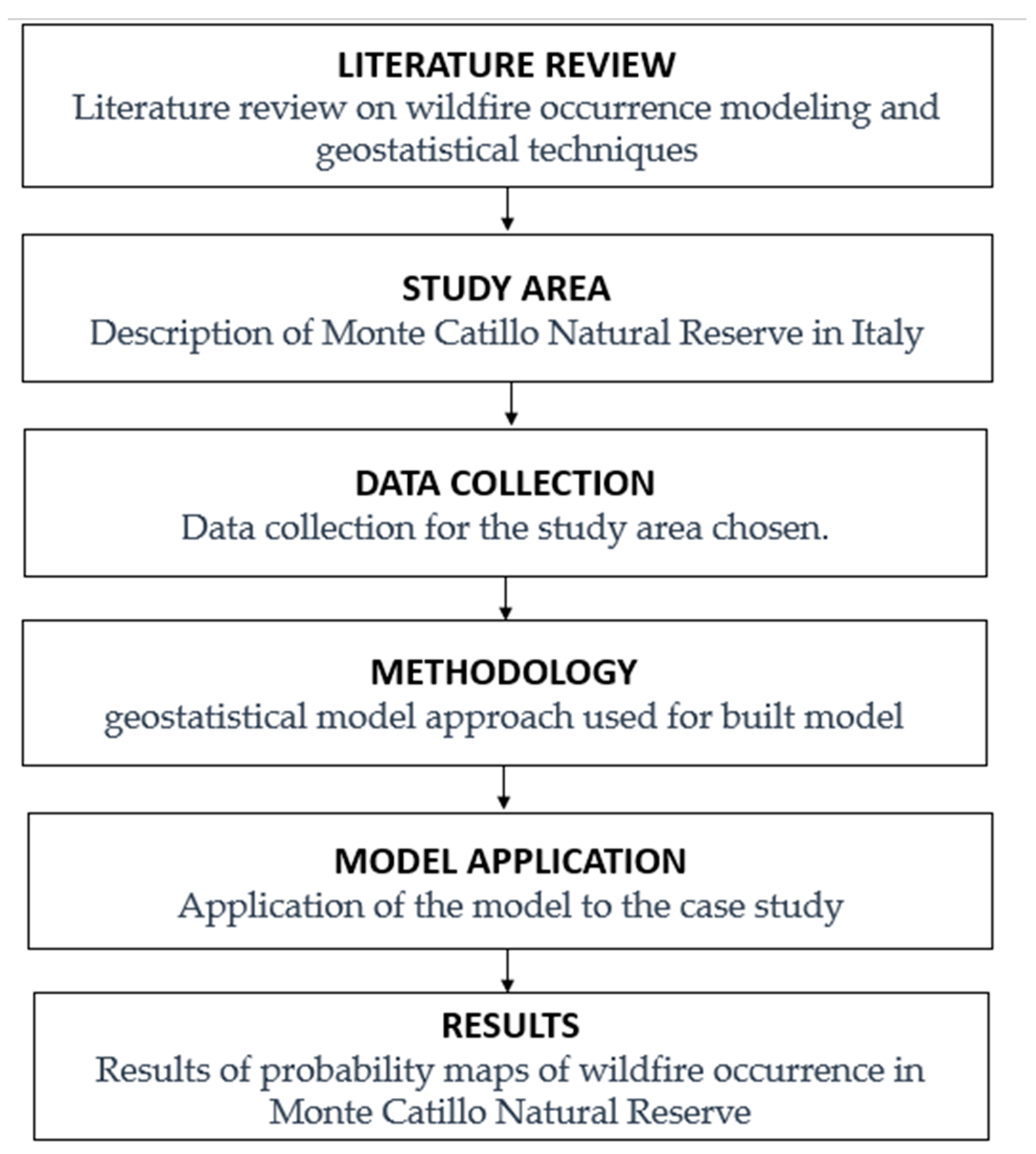
Figure 1. Workflow of the research in the study area of Monte Catillo Natural reserve.
Fire 06 00427 g001
Figure 2. Territorial Framework Map of Monte Catillo Nature Reserve [40].
Fire 06 00427 g002
Figure 3. Territorial destination uses Map of Monte Catillo Nature Reserve [40].
Fire 06 00427 g003
Figure 4. In blue circle phytoclimatic Map of Monte Catillo Nature Reserve, area of Tivoli, Rome.
Fire 06 00427 g004
Figure 5. In the two images is observed the vegetational appearance of the Ampelodesmos Mauritanicus species [43].
Fire 06 00427 g005
Figure 6. Map of Previous Fires in the Monte Catillo Natural Reserve during the Observation Period 2010–2019.
Fire 06 00427 g006
Figure 7. (a) Number of fires over years (2010–2019); (b) Number of fires over time interval (2010–2019); (c) Number of fires over location (2010–2019). [44].
Fire 06 00427 g007aFire 06 00427 g007b
Figure 8. Flow chart of the dataset preparation.
Fire 06 00427 g008
Figure 9. Trigger Points of vegetation A in the study area with roadside buffer.
Fire 06 00427 g009
Figure 10. Trigger Points of vegetation B in the study area with roadside buffer.
Fire 06 00427 g010
Figure 11. Trigger Points of vegetation A with roadside buffer.
Fire 06 00427 g011
Figure 12. Trigger Points of vegetation B with roadside buffer.
Fire 06 00427 g012
Figure 13. Subdivision done in the study area with the comparison of all the 64 cells and the only ones which belong to Monte Catillo Natural Reserve.
Fire 06 00427 g013
Figure 14. The image depicts cells with configurations, on the left without vegetation related to A and B, while in the center and on the right, cells with the co-presence of a road buffer. At the bottom is the legend.
Fire 06 00427 g014
Figure 15. Cells with the presence of Categories A and B, and the others.
Fire 06 00427 g015
Figure 16. The image displays cells with the presence of Categories A and B, as well as the remaining ones, in accordance with the vegetational configuration of Monte Catillo Nature Reserve.
Fire 06 00427 g016
Figure 17. On the left side the entire Vegetation Map and the road buffer. On the right side the road buffer and the vegetation of Categories A (green) and B (blue).
Fire 06 00427 g017
Figure 18. Cells that have vegetational characteristics of Categories A and B that depict the road buffer.
Fire 06 00427 g018
Figure 19. Trigger Points probability in the Monte Catillo Natural Reserve.
Fire 06 00427 g019
Table 1. Monte Catillo Nature Reserve divided into nine areas with homogeneous vegetation characteristics, perimeters, and extent of the area, each with its respective reference locations.
Homogeneous
Vegetation Areas
LocationArea (ha)Perimeter (km)
Vegetation Area 1Crocetta/S.Paul crossroads/SS549.766.12
Vegetation Area 2Saint Paul crossroads72.024.71
Vegetation Area 3Crocetta/Monte
Catillo/Colle Piano
140.746.80
Vegetation Area 4Fonte Bologna/Colle Lucco/S. Polo385.8214.41
Vegetation Area 5San Polo/ Cava Marcellina161.766.45
Vegetation Area 6Marcellina/Cava Marcellina75.545.56
Vegetation Area 7Monte Sterparo/Fosso dell’Obaco164.708.34
Vegetation Area 8Monte Sterparo/Fosso dell’Obaco273.7310.92
Vegetation Area 9Santa Balbina20.073.31
Table 2. Homogeneous vegetation areas, number of ignition points, and their percentage of the total.
Homogeneous
Vegetation Areas
Number
of Fires
Percentage
Vegetation Area 118%
Vegetation Area 200%
Vegetation Area 3215%
Vegetation Area 400%
Vegetation Area 500%
Vegetation Area 600%
Vegetation Area 7323%
Vegetation Area 8754%
Vegetation Area 900%
Table 3. Calculation and statistical representativeness verification of the Poisson λA,s distribution coefficient.
Events
k
Observed
Frequencies
f o
Probability
P λ k = λ k k ! e λ
Observed
Frequencies
f e
χ2 Test
( f o f e ) 2 f e
050.39984.79820.0085
140.36654.39830.0361
220.08401.00800.9764
310.00860.10277.8434
400.00050.00590.0059
Table 4. Calculation and statistical representativeness verification of the Poisson λB,S distribution coefficient.
Events
k
Observed
Frequencies
f o
Probability
P λ k = λ k k ! e λ
Observed
Frequencies
f e
χ2 Test
( f o f e ) 2 f e
0110.920011.04050.0001
110.07670.92000.0069
200.00160.01920.0192
Table 5. Probability of fire within the grid cells with the presence of vegetation categories A and B in interference with the roadside buffer.
Cell
Number
Vegetation Area A with Road Buffer [m2]Vegetation Area B with Road Buffer [m2] 1 P A , S 0 1 P B , S 0 P k > 0 1 P k > 0 [year]
Cell 104750.60020.08000.00017313.7
Cell 229,28942,8840.60020.08000.087511.4
Cell 3081280.60020.08000.0023427.4
Cell 423,04118,4810.60020.08000.064515.5
Cell 522,73264680.60020.08000.060216.6
Cell 6409634,5680.60020.08000.020548.9
Cell 771,22479,4980.60020.08000.20574.9
Cell 8408200.60020.08000.010595.4
Cell 930,48531,2930.60020.08000.087311.5
Cell 10240918,1130.60020.08000.011487.7
Cell 11955126,9620.60020.08000.032331.0
Cell 12856415730.60020.08000.022444.6
Cell 1313,07400.60020.08000.033629.8
Cell 1415,26900.60020.08000.039225.5
Cell 15093250.60020.08000.0027372.5
Disclaimer/Publisher’s Note: The statements, opinions and data contained in all publications are solely those of the individual author(s) and contributor(s) and not of MDPI and/or the editor(s). MDPI and/or the editor(s) disclaim responsibility for any injury to people or property resulting from any ideas, methods, instructions or products referred to in the content.