Article

A Historical Perspective to Inform Strategic Planning for 2020 End-of-Year Wildland Fire Response Efforts

1
USDA Forest Service, Rocky Mountain Research Station, Human Dimensions Science Program, Fort Collins, CO 80526, USA
2
USDA Forest Service, Rocky Mountain Research Station, Fire, Fuel, and Smoke Science Program, Missoula, MT 59808, USA
3
USDA Forest Service, Rocky Mountain Research Station, Human Dimensions Science Program, Missoula, MT 59801, USA
*
Author to whom correspondence should be addressed.
Submission received: 2 February 2022 / Revised: 23 February 2022 / Accepted: 27 February 2022 / Published: 1 March 2022

Abstract

:
A severe outbreak of wildfire across the US Pacific Coast during August 2020 led to persistent fire activity through the end of summer. In late September, Fire Weather Outlooks predicted higher than usual fire activity into the winter in parts of California, with concomitant elevated fire danger in the Southeastern US. To help inform the regional and national allocation of firefighting personnel and equipment, we developed visualizations of resource use during recent late season, high-demand analogs. Our visualizations provided an overview of the crew, engine, dozer, aerial resource, and incident management team usage by geographic area. While these visualizations afforded information that managers needed to support their decisions regarding resource allocation, they also revealed a potentially significant gap between resource demand and late-season availability that is only likely to increase over time due to lengthening fire seasons. This gap highlights the need for the increased assessment of suppression resource acquisition and allocation systems that, to date, have been poorly studied.

1. Introduction

An accounting of available wildfire suppression resources (i.e., firefighting personnel and equipment) is critical for determining whether a proposed strategy to manage a large wildfire is likely to succeed or is even feasible. While the Type 1 and Type 2 Incident Management Teams (IMTs) that manage large fire events order the resources that should allow them to achieve desired outcomes, final resource assignments are outside of their control. IMTs can develop better strategies if they know which resources will be available, but in the United States (US) a combination of resource scarcity and an entrenched, opaque, hierarchical prioritization system leads to much uncertainty regarding actual availability [1].
In the US, resource assignments depend on a highly complex, three-tiered, multiagency system [1]. Within this system, local dispatch centers are responsible both for sending resources out to respond to initial fire reports and for filling resource orders from large fire incidents. Geographic Area Coordination Centers (GACCs) are responsible for facilitating regional-level resource sharing between non-neighboring local areas and supplying additional resources once local resources are depleted [2]. There are ten GACCs in the US, each associated with a specific geographic area (Figure 1). The National Interagency Coordination Center (NICC) is responsible for facilitating resource sharing between geographic areas and supplying national resources to geographic areas once regional and local resources are depleted [1]. Each fire season, this system oversees the distribution of firefighting resources that travel extensively to provide support for large incidents [3,4]. Even with this additional capacity provided by national-level resource sharing, geographic areas still routinely have challenges with resource scarcity [4].
To address the task of allocating scarce suppression resources between multiple fires being managed by a variety of agencies, the FIRESCOPE project formalized the concept of a multiagency coordination (MAC) group in the 1970s and 1980s. The system was developed as a series of compromises from all agencies involved. The MAC framework was designed to allow multiple organizations to work together to efficiently respond to emergency situations [5]. In practice, when resources become scarce at the geographic area level, a geographic MAC group is formed and given authority to prioritize incident- and local-resource allocation within a geographic area [2]. Similarly, when resources become scarce at the national level, the National Multi-Agency Coordinating group (NMAC) is established to determine how resources are distributed between geographic areas [1]. The GACCs and NICC provide the logistical capacity to carry out the decisions made by the MAC groups. Thus, the MAC groups’ decisions play a crucial role in determining feasible strategies for individual wildland fires; their decisions on which geographic area or fire will receive resources limit the decision space in which IMTs can operate. Area Command Teams (ACTs) may also be used to support multiple ongoing fires occurring in close proximity; these teams are empowered to shift resources between the incidents under their control without needing MAC group approval. The roles filled by ACTs go substantially beyond resource allocation decisions; they can provide operational support in diverse operations areas such as risk management, human resource management, agency administrator support, communication and coordination, strategic oversight and direction, natural and culture resource consideration, fiscal concerns, information management, and documentation. A conceptual diagram of the resource sharing system, including the role ACTs play in resource allocation, is provided in Figure 2. In each management arena (national, geographic area, and local) and within each decision-making entity (e.g., NICC, NMAC, GACC, MACs, and ACTs) the mission to efficiently distribute scarce resources critically requires knowledge of resource availability.
Decades of research on decision-making have shown that well-presented, timely data can help decision-makers improve decision quality [6,7,8]. For example, [9] demonstrates the value of providing decision-makers with a comprehensive, multi-agency database documenting fuel management activities in California. Because of the highly complex environment in which wildland fire resource assignment decisions are made, decision-support tools have the potential to improve decisions, particularly during widespread pulses of demand for resources. There are several existing decision-support products used by MAC groups and the NMAC group to provide fire weather risk [10], ongoing fire information [11], and fuels and fire behavior risk [12]. In addition, most MAC groups have independently developed decision-support tools such as multi-criteria hierarchical ranking to help prioritize fires that are currently burning within a geographic area [2]. MAC groups are typically supported by intelligence personnel who organize information regarding ongoing fires and short-term (three to seven days) resource availability. To date, analyses using historical resource use and availability data to inform longer term (monthly to seasonal) resource planning activities have been limited, and current availability does not necessarily help predict future resource availability. This is particularly relevant nearing the end of the traditional fire season, as temporary resource contracts may expire, and permanent resources may become available only for local or regional use or choose to turn down assignments due to fatigue.
In wildland fire management, there are many barriers to delivering historical resource use and availability data to the right people, at the right time, and at the right management level. First, resource use data are usually pulled from a dispatching database, incident management records, or local management units and are therefore incomplete, may include duplicate data, and are generally challenging to work with. Therefore, the appropriate data to support complex wildland fire decisions are challenging to acquire, parse, and interpret and are intractable to anyone who is not a specialist or expert. There are few experts who can access and manipulate the data, and they do not all exist in incident support positions; rather, they often exist in other roles such as dispatching or research. Links between researchers and managers can be challenging to develop for real-time decision support, as researchers are expected to be at the forefront of knowledge discovery, and the support of real-time management decisions can divert them from their primary research objectives.
The Risk Management Assistance program has been working to bridge this divide in recent years and has made substantial progress [13], but information gaps remain, particularly surrounding resource availability. Such challenges result in a limited ability to use such data in decision support systems in time to inform critical decisions [14,15]. As GACCs work to plan how to respond to future incidents, the uncertainty surrounding resource availability can make for sub-optimal decisions. This is particularly critical in the current environment; there is substantial evidence that fire seasons are lengthening [16,17], the annual area burned is increasing [18,19,20], and the simultaneous occurrence of large wildland fires will become more frequent [21,22]. Additionally, to address issues with staffing shortages and employee wellness, many state and federal firefighting agencies are reforming workforce policies to improve recruitment, retention, and employee morale through improved pay and benefits for wildland firefighters [23,24,25]. In the meantime, many fire agencies across the country remain understaffed [26], and this has serious implications for wildfire response capacity, particularly during periods of high concurrent fire demand. These challenges are likely to lead to novel demands for wildland fire response personnel and equipment, increasing future uncertainty surrounding resource availability.
In this paper, we present a case study demonstrating the value of providing managers with the best available data, delivered in highly customized and functional formats to support real-time decisions. In the fall of 2020, numerous lightning events along with several ongoing large fires on the US West Coast led to an extreme amount of fire on the landscape in California (see Figure 3) and the Northwest geographic area (Washington and Oregon; see [27] for additional information). The Fire Weather Outlook predicted higher than usual fire activity to continue throughout the fall and into the winter in parts of California, along with higher than usual fire activity in the Southern geographic area in November [28]. With many fire personnel finishing their season and becoming unavailable for assignments, in addition to an already reduced set of crews in California due to the COVID-19 pandemic, the US Forest Service Pacific Southwest Region 5 (R5) was concerned about managing high late-season fire risk. The R5 boundaries are nearly coincident with the boundary of the state of California; wildland fire resource allocation in that state is overseen by the Northern and Southern California GACCs and the two associated MAC groups [2]. R5 requested that an ACT be assigned to help support complex resource assignment decisions in this critical environment. One of the most pressing questions was how to manage the limited resources for the expected future demand. However, an accounting of resources likely to be available, historical assignment patterns, and assignment durations were not readily visible to key decision-makers. To fill this gap, the ACT engaged Forest Service Research to help produce an analysis of historical resource use; collaboration with Forest Service Research was a critical component to complete the analysis due to their expertise and ongoing work on suppression resource availability and movement (e.g., see [4]). We present this case study along with an improved analysis framework for addressing critical future information gaps that are likely to emerge.

2. Materials and Methods

2.1. Identification of Areas of Concern and Data Gaps in Fall 2020

The multiagency environment of wildland fire in the US has always created challenges for managers, especially when predicting resource availability, and these challenges were amplified by the COVID-19 pandemic [30,31,32,33]. There were restrictions on the sharing of resources between geographic areas as a precaution against spreading COVID-19 [34]. A large portion of California’s Type 1 state crews (20 person modules used for wildfire suppression) were not available for the 2020 fire season due, in part, to the risk of COVID-19 [35,36]. These Type 1 crews are a large part of the response system in California and their loss highlighted a key challenge for the multiagency fire system: agencies make decisions independently regarding the resources they have on staff, which impacts the resources available to any interagency effort to respond to fires. In the past, coordination between agencies has been crucial to fire response, but interagency coordination has focused on allocating resources that are available in the coming one to two weeks rather than looking at longer-term future resource availability.
In the fall of 2020, Forest Service managers in California were concerned that the forecast of high late-season wildfire activity and the reduction in traditionally available suppression resources would create significant management challenges. Area Command Team 2 (ACT2) was mobilized and briefed in early September 2020 by the Assistant Directors of R5 Fire and Aviation Management (FAM). The assignment was defined as one of coordination and support, rather than the command function usually fulfilled by an ACT. The primary tasking was to develop a Regional Strategic Plan in preparation for October–December 2020, which also could be useful in future years. Primary plan objectives were to (1) identify potential gaps between resource needs and availability and (2) produce analytics that could help decision-makers use resources most efficiently and effectively. The work outlined in this manuscript addresses objective (1); objective (2) was addressed by a different effort (see [37] for details). ACT2 routinely engages with Forest Service Research; several Forest Service Researchers fill positions on ACT2 as Technical Specialists. To address objective (1), these researchers and their colleagues (i.e., the authors of this paper) developed plausible scenarios of resource demand based on assessments of needs realized in three recent high-activity late season (October–December) years and the challenges expected nationally with potential competition for resources. Resources of particular concern for managers were IMTs, crews, engines, dozers, and aviation assets; thus, those were the resources included in the analyses.

2.2. Data Sources

The most comprehensive source of assignment data for historical wildland fire suppression resources is the Resource Ordering and Status System (ROSS). We obtained all assignments for IMTs, crews, engines, dozers, and aerial resources (airtankers and helicopters) for wildland fire incidents from 2016, 2017, and 2018. Assignments were attributed by the geographic area of the ordering incident and by the agency that owned or provided the responding personnel or equipment. We also counted the requests for resources that the fire system was “Unable to fill” (UTF). We did not use data from 2019, as 2019 late-season fire activity was minimal and would not have provided a useful perspective for periods that required substantial late-season resource demands. See [3,4,30,38,39,40,41] for other peer-reviewed studies that have used this assignment data.
The assignment data were further stratified by resource type, as different types of crews, engines, aerial resources, and IMTs have differing capabilities. There are four types of crews tracked: (1) Interagency Hotshot Crews (IHCs), (2) Type 1 State and Local (T1 ST/L) crews, (3) Type 2 Initial Attack (T2IA) crews, and (4) Type 2 (T2) crews [42]. The T1 ST/L crews are primarily comprised of crews provided through the California Department of Corrections and Rehabilitation (CDCR). There are seven engine types, which we classified into two classes. Type 1 and 2 (T1–T2) engines are the largest of engines, are typically confined to use on paved roads, and are often involved in structure protection. Type 3, 4, 5, 6, and 7 (T3–T7) engines are smaller vehicles that may be used on unpaved roads and for tasks that may not directly involve structure protection [42]. Airtankers deliver water or retardant and are typed according to aircraft volume capacity. Very large (>8000 gal), Type 1 (3000–5000), and Type 2 airtankers (1800–2999) are grouped in our analyses and labeled as “Large Airtankers”. “Smaller Aircraft” include Type 3 (800–1799 gal) and Type 4 airtankers (<800 gal) [43]. IMTs are also classified by type, indicating the level of complexity they are qualified to manage. Type 1 (T1) IMTs manage the largest and most complex wildfires. Type 2 (T2) IMTs are also highly qualified, though not as highly staffed or trained as T1 IMTs, and they also manage major wildfires. The National Incident Management Organization fields four T1 Incident Management Teams (NIMO), which we tracked separately from the other T1 IMTs [42].
IHCs are a resource of particular importance, as they are the most highly qualified type of crew and they can perform operations that other crews cannot, such as complex firing operations [42]. IHCs are seasonal resources; however, seasons are not standardized and there was uncertainty around exact end dates for all IHCs. Because IHCs were a resource of particular concern, the projected availability data for each crew were collected individually, to determine when they would become unavailable. This was feasible for IHCs because there are a limited number of them (115 crews in 2020). Collecting this type of availability data for all resources of interest was infeasible due to the high number of resources as well as the large number of agencies under which the resources are contracted and employed.
Aircraft assignments generally differ from other resource assignments in that they are often of short duration (less than a single operational period), and sometimes single aircraft may respond to multiple fires in one day. This is particularly true for airtankers, which are relatively scarce and highly valuable resources [44]. To most accurately characterize historical aircraft utilization, as well as large airtanker use and availability, ROSS data were supplemented with Aviation Business Systems (ABS) data, which track costs associated with aircraft availability and flight time for the US Forest Service [4,40]. Supplementing ROSS data in this way also helps account for any underreporting of airtanker use (for example, see the discussion in [4]). However, regional dispatch practices in California tend to adhere to established guides, so we were comfortable providing that data to managers as a reasonable estimate of historical airtanker use. We also gathered the number of large airtankers on exclusive use contracts that were available daily in 2018 [45]. While the number of airtankers on such contracts is available for 2016 and 2017, we did not collect that data, as significant changes resulting from fleet modernization efforts made the data inapplicable for consideration in 2020.

2.3. Data Preparation and Analytics
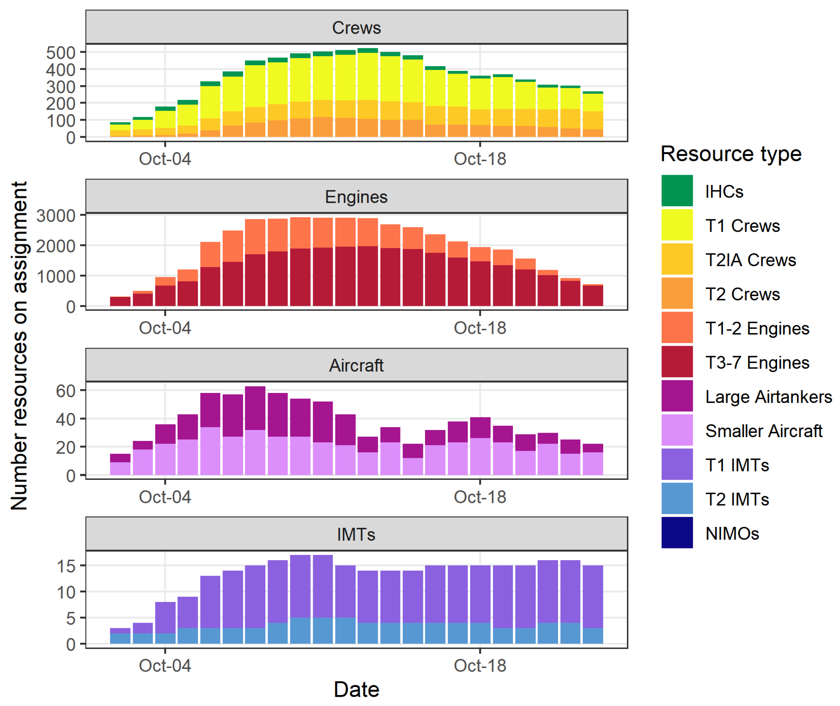
We provided an overview of IMT, crew, engine, dozer, and aerial resource assignments by year. We then delved more deeply into resource assignments, looking at the use of each type of resource by geographic area and provider agency.
In 2016, 2017, and 2018, there was substantial late-season resource use, but the resource demands only occurred in a single geographic area each year. In 2020, there were plausible fire activity scenarios predicted that would have seen substantial fire activity within the Northern and Southern California geographic areas as well as within the Southern geographic area. We created two hypothetical scenarios to provide decision-makers with an estimate of resource needs in the event that California and the Southern geographic area had high concurrent levels of wildland fire response needs in the late season of 2020.
The first scenario was comprised of each geographic area’s maximum daily use of each type of resource from October to December. For each day, we determined the maximum number of crews, engines, helicopters, airtankers, and IMTs used by each geographic area. We summed those maximum use counts from each geographic area to create that day’s national “maximum daily use.” This produces a scenario with three separate pulses of substantial fire activity, as the fire activity occurrences in 2016, 2017, and 2018 did not occur on the same days of the year. This “maximum daily use” scenario provides context for resource needs if individual geographic areas experience high levels of fire activity independently for sustained periods over the final quarter of the year. However, daily resource needs could be higher than estimated in the maximum daily use scenario if multiple geographic areas did have pulses of high fire activity at the same time.
To address the concern that the maximum daily use scenario might not adequately represent the potential impacts of simultaneous fire activity on resource use, we developed a second resource use scenario. In this, we compiled the three weeks of resource needs from Northern California following 7 October 2017, from Southern California following 1 December 2017, from the Southern Area following 8 November 2016, and the rest of the geographic areas following 1 October 2018. This provides a “simultaneous use” scenario for resource needs that could occur if fire activity were synchronous.

3. Results

The data were presented to R5 managers in a series of graphs. While these graphs were produced for the entire set of resource types identified as being of interest to managers, we only reproduce the graphs that provide the most compelling insights here. The graphs have been altered slightly from the original versions presented to managers to facilitate ease of interpretation in a publication format.
As mentioned previously, the data on 2020 IHC availability was collected manually (pers. comm., Greer; Figure 4a); this data confirmed a very limited number of IHCs available after the end of October 2020. Southern California retains IHCs further into the year, yet still has just two IHCs available into late November/early December. Extensions and/or the modulization of resources after their baseline end dates were possible, but in 2020, there was little interest by the crews surveyed (e.g., from SW; Shane Greer, personal communication) and very few crews chose to go this route. Data collected by the IHC Steering Committee (pers. comm Larry Money, Aaron Schuh, Kyle Betty; Figure 4b) confirm that the late-season availability of IHCs was not abnormal but matched the late-season availability from the past several seasons.
Figure 5 shows the daily number of crews assigned to fires in ROSS during October, November, and December of 2016, 2017, and 2018. As previously mentioned, in 2020, over half of the T1 ST/L crews were unavailable due to the COVID-19 pandemic. With most IHCs approaching their season-end dates (Figure 4) in addition to the absence of the T1 ST/L crew, this depiction of previous late-season crew usage (particularly the high reliance on ST/L crews in the past) also confirmed the substantially limited availability of crews in late 2020.
Figure 6 shows the daily number of engines assigned to fires in ROSS for the same period. This graph shows that the high-activity late-season demand for engines in 2017 and 2018 was met largely by nonfederal resources. The 2017 spike in mid-December engine use is associated with the 281,893 acre Thomas Fire [46], which was the largest fire in California’s modern history at the time. This fire burned mostly on Forest Service lands, though it used mostly non-Federal engines. This raised concerns about engine availability for fires on Federal lands, given that non-Federal resources are not guaranteed to be available.
Airtankers are privately owned and contracted for government use. Federal exclusive use contracts typically cover 160-day mandatory availability periods, and while most start dates are in the spring, these vary to accommodate different geographic area demands [45]. Post-season use provisions are available on existing contracts, but this availability is not guaranteed. Figure 7 was provided to managers to highlight late season use patterns for large airtankers for the analysis years. Flight hours vary widely between years for August and September but generally decrease dramatically after October. A mid-October 2017 spike in flight hours from ABS is attributed to the widespread occurrence of large and destructive wildfires that ignited across Northern California on 8 and 9 October 2017 (e.g., Atlas, Tubbs, Nuns, LNU Complex). A small December spike in flight hours in 2017 is attributed to the Thomas Fire, but the burst in activity is relatively small because it did not involve the activation of the entire federal fleet. There were also several large fires burning in Southern California in November 2018 that requested airtankers (Figure 7b); the majority of those airtankers were provided by the state of California. Again, many of the large airtanker requests to the Thomas Fire in 2017 were provided by the state of California. It is important to note that California owns its own fleet of 23 smaller multi-engine airtankers [47], which are used to meet intra-state demand. Further, California contracts with the same private vendors for exclusive state use of one or two large and very large airtankers, but the details of these contracts vary and are not published.
The maximum daily use scenario was derived from the historical resource assignment from 2016 to 2018; some of the resource demands that might be associated with such a scenario are shown in Figure 8. In this case, when the fire activity is spread across the late season rather than occurring simultaneously, many resources would be needed for the duration of the season. However, in such a scenario, the peak number of resources needed on a single day would not be substantially more than has been observed historically. Despite this, the potential lack of state and local resources would have made it more challenging for fire managers to meet such levels of resource demand in 2020 than in previous years.
In addition to crew, engine, and airtanker demand, Figure 8 also shows potential IMT usage, which was another critical resource concern. In 2020, three geographic areas were simultaneously experiencing high levels of fire activity and could have had active fires on the landscape continuously through December. Thus, in October, most IMTs had already been on multiple assignments, and most had extended more than once, some working consecutive 21-day assignments. The results in Figure 8 show that continuous fire activity through December would have substantially stressed the already tired IMTs, potentially requiring relief teams to allow for necessary rest.
The results from the simultaneous use scenario are shown in Figure 9, which provides an example of resource needs if the historical fire activity had occurred simultaneously. This was a plausible scenario for the late season of 2020, given the forecasts of potential for large fire behavior in California and the Southern geographic area. In such a scenario, the demand for crews, engines, and aircraft would be substantially beyond the resource use in the late seasons of recent history. Acquiring the crews, engines, and aircraft to respond to such demand would be remarkably challenging, and the substantial demand for resources would likely go unfilled.
An important aspect of the maximum daily and simultaneous use scenario results is the characteristics of the fires that were represented in this sample of assignment data. Both scenarios included data from the Thomas Fire and the Central LNU complex, which are both fires with anomalous daily resource usage. According to the ROSS records, the Thomas Fire ranks first in the total number of personnel assigned to a fire on a single day across all fires occurring in 2016 through 2019, and the Central LNU Complex ranks seventh. Regardless of fire specifics, the data do show that, historically, the fire system had the number of resources available in the late season to provide coverage for the maximum daily use scenario, though never for that long of a duration. In contrast, the system has never been tested in the off-season by demand even close to the simultaneous resource use scenario, and would likely need to severely ration resources if such a scenario were to ever occur.

4. Discussion

The data products we provided were featured in the final ACT2 presentation to the Northern California Geographic Area. In addition, the products were prominent in the Pacific Southwest Region 2020 Wildfire Situation Regional Strategic Plan, October–December 2020 [37]. In this publication, the ACT used the historical context and plausible scenarios to conclude that the system is not well-positioned to address high fire activity in the fall and early winter and put forward several long-term policy suggestions to address this issue in the future. The publication also recommended developing strategies to deal with short term resource shortages in the fall and early winter of 2020 and, in support of this, the publication featured a variety of other tools provided by researchers and analysts to help managers prioritize resource requests in the event of substantial fire activity and resource scarcity. Some of the results were also used in the Length of Season Report developed for reference in preparation for future seasons [48]. Although the forecast for continued high to extreme fire activity did not occur in California in 2020, a serious vulnerability in the fire management system was identified. These analyses highlight the need to address resource availability in what was historically the shoulder- or off-season but is now a period that can see large wildfire events (e.g., Chimney Tops 2 Fire, Thomas Fire, Camp Fire).
The collaboration documented in this manuscript between fire managers and researchers demonstrates the challenges of providing managers with the best and most appropriate data for real-time decision support and also shows the value of such products. As demonstrated by this case study, fire managers may not have timely access to the information that they need (regarding resource use, in this case). This is, in part, because analysts with detailed knowledge of data sources and the methods to parse them are still rare. Data access is also challenging; identifying key data on resources and providing a standardized location and format for such data would increase the efficiency of related analyses. Current practice requires highly experienced personnel, and the current data management system creates opportunities for error and results in delays that may render the information obsolete for informing real-time decisions. For example, even for IHCs, which are a critical national resource and are relatively well-tracked, obtaining each crew’s season end date was a time-consuming task that had to be done by contacting each crew individually. Similarly, aircraft availability varies across and between years; given the complexities of the contracting systems in a multiagency environment, fleet availability may be unclear. A recent publication developed a list of barriers to the use of science in wildland fire management [49]. While the publication documents several critical barriers reflected in the current literature, missing from that list was the challenge in applying science because of the lack of expert analysts; currently, without such analysts, it is very challenging to build data-driven decision support products to support wildland fire managers in real-time.
The availability of data and decision support for managers is likely to become more important in the coming years as the fire environment continues to evolve and the impacts of climate change intensify. The fire activity observed during the 2020 fire seasons in California provides an example of what may become common in the future [50]. By the end of 2020, the US government had spent $2,274,000,000 on suppression expenditures for fires that burned across 10,122,336 acres [51], driven in part by lightning events followed by wind events that occurred during record-setting heat waves [52]. The damages caused by the 2020 fire season additionally highlight the importance of wildland fire management; for example, 2020 saw 17,904 structures lost to wildfire [52]. The challenges faced by fire managers in such an extreme environment are compounded by the interagency nature of the wildfire management system. For example, the interdependence of agencies on each other’s resources is a critical factor for managers to consider. The current multiagency system leads to a high vulnerability for the whole system if one player changes the availability of their resources. For the 2020 fire season, this was demonstrated by the unanticipated limitations on the Type 1 crews typically provided by the state of California due to the COVID-19 pandemic. Other agencies may also be constrained by unanticipated changes regarding budgets or personnel availability in the future.
Increased fire activity is not the only potential shock that the wildland fire system may experience. In 2020, the system experienced both a high level of simultaneous fire and the COVID-19 global pandemic. In 2021, the wildland fire community experienced other resource shortages [53], as well as fire behavior that was unprecedented. The wildland fire response community should expect other such systemic shocks in the future, as the changes in fire activity and workforce availability are moving wildland fire response resource needs into unexplored territory. While historical resource use data will be valuable for managers as they continue to learn from previous fire seasons, resource-use metrics from previous seasons may not be sufficient for predicting shoulder- and off-season resource use, as they are based upon the limited availability of wildland firefighting resources in those seasons. For example, IMTs may not bother to place an order in the system for resources they know are unavailable. Thus, the demand for resources in the shoulder and off-seasons may be poorly documented. In addition, creating hypothetical resource use scenarios is challenging and deserves further consideration. For this analysis, we were time-constrained, thus, our scenarios were simple, to provide managers with reasonable scenarios in a timely manner. Despite their simplicity, they did provide regional- and national-level fire planning staff with perspectives to which they otherwise would have had no access.
Not only will these products be important for managers making real-time decisions to provide resources to fires in real-time (i.e., the MAC groups), but they will also be critical for decision-makers who are tasked with designing the wildfire response workforce. The current wildland fire response system in the US was designed around fire activity that typically occurred during a more tightly defined season. The expanding fire seasons will likely require more resources in the fall and winter seasons than have been needed in the past. This gap has been recognized but not yet fully addressed. For example, the US Forest Service has been making an effort to transition some of their seasonal workers to permanent workers [54]. However, simply extending existing resources for longer periods of time may exacerbate the identified mental and physical health issues fire responders are currently experiencing [55,56,57,58]. In addition, periods of simultaneous large fire activity are expected to increase, potentially leading to higher peak demand during the summer season, so simply extending seasons may not holistically address the need for wildfire response capacity. Ongoing efforts to change the fuel conditions that have helped lead to higher levels of fire activity may also impact resource needs. Experienced fire crews and resources are needed in the shoulder seasons to accomplish prescribed burning, and in some cases, other specialized fuel treatments, further lengthening their seasons of active field work. The careful consideration of potential resource needs is warranted to balance the range, timing, and coincidence of likely resource demands under future management scenarios.
Analyses examining historical wildfire resource use may also be useful at different management scales than the examples provided here. For example, local-level decision-makers such as National Forest or Bureau of Land Management District managers may benefit from similar analyses examining the origin of resources used over the season on large wildfires within their management unit. Such analyses would allow managers to carefully examine when local resources have historically been able to fill local needs, when local needs have historically exceeded local resource capacity, and to then consider if the external resources that have historically supplemented local resources are likely to be available in the future.
Additional analyses examining resource use on fires may also be useful. Using assignment data provides managers with a historical record of the fires to which resources were assigned but gives no information about what capacity they were providing for the fire or how they were contributing to achieving fire objectives. There are many examples of IMTs ordering additional resources or holding on to resources that are not contributing to containment in the event that an unanticipated or low-likelihood event occurs, while other IMTs unsuccessfully seek resources for their fires that would provide critical capacity towards fire containment (pers. comm. Tim Sexton). Analyzing resource contributions on individual fires would substantially increase MAC groups’ ability to proactively move resources to the fires where they would provide the most value.
In 2020, the ROSS software was replaced by a new dispatching software and database system called the Interagency Resource Ordering Capability (IROC). This system introduced the ability for those with access to develop their own dynamic dashboards based on custom database queries. To create such dashboards, users must be familiar with the assignment data and must have direct access to IROC. While this functionality does provide managers with valuable contextual information, it still requires an IROC subject matter expert to develop the dashboard, and the dashboard functionality has been tailored to daily current information rather than to projections or historical analyses.
Readily available resource data could be particularly useful if paired with emerging technology. For example, recent advances in modeling near-term fire spread using satellite or other imaging data (for example, [59,60,61]) could be used in conjunction with resource availability data to help prioritize resource assignments [61], particularly during times of resource scarcity. Additional technological advances such as unmanned aerial vehicles may also provide support for both data collection (e.g., imaging) and suppression actions (e.g., backfire operations). However, even if substantial improvements in the prediction of fire spread and fire suppression technology are realized, data on the resources available to work on fire suppression will still be critical.
The analytics developed in this manuscript highlight some characteristics of the wildland fire system that managers will need to consider as they develop a vision for a wildland fire response system in the future. Therefore, because the fire system is a national, multiagency system, we need modeling and data products at the national level that consider the multiagency nature of the problem and the regional demand patterns. This case study highlights the significant value of investments in modern data management systems and associated analytical platforms to support high-impact decisions.

Author Contributions

Conceptualization, D.E.C. and K.C.S.; methodology, E.J.B. and C.S.S.; formal analysis, E.J.B. and C.S.S.; investigation, E.J.B., C.S.S. and K.C.S.; resources, D.E.C.; data curation, E.J.B. and C.S.S.; writing—original draft preparation, E.J.B. and D.E.C.; writing—review and editing, C.S.S. and K.C.S.; visualization, E.J.B. and C.S.S.; supervision, D.E.C. and K.C.S.; project administration, D.E.C.; funding acquisition, D.E.C. All authors have read and agreed to the published version of the manuscript.

Funding

This research was supported by the U.S. Department of Agriculture (USDA) Forest Service and was funded in part by joint venture agreement number 18-JV-11221636-099 between Colorado State University and the USDA Forest Service Rocky Mountain Research Station.

Institutional Review Board Statement

Not applicable.

Informed Consent Statement

Not applicable.

Data Availability Statement

The data from the Resource Ordering and Status System (ROSS) and the ABS used in this study is not publicly available due to privacy considerations.

Acknowledgments

The authors would like to thank Tim Sexton for his help and insights, particularly while we were preparing these data products for managers.

Conflicts of Interest

The authors declare no conflict of interest. The funders had no role in the design of the study; in the collection, analyses, or interpretation of data; in the writing of the manuscript; or in the decision to publish the results.

Disclaimer

The findings and conclusions in this report are those of the author(s) and should not be construed to represent any official USDA or U.S. Government determination or policy.

Abbreviations

ABSAviation Business Systems
ACTArea Command Team
ACT2Area Command Team 2 (the name of a specific ACT)
EXUExclusive Use (a type of airtanker contract)
FAMFire and Aviation Management (a branch of the US Forest Service)
GACCGeographic Area Coordination Center
IHCInteragency Hotshot Crew
IMSRIncident Management Situation Report
IMTIncident Management Team
IROCInteragency Resource Ordering Capability
LATLarge Airtanker
MACMultiagency Coordination Group
NICCNational Interagency Coordination Center
NIMONational Incident Management Organization
NMACNational Multiagency Coordination Group
R5Region 5; the US Forest Service Pacific Southwest Region
ROSSResource Ordering and Status System
ST/LState and Local
T1Type 1
T2Type 2
T1–T2Type 1 or Type 2 (generally used to distinguish structure engines)
T3–T7Type 3 through Type 7 (generally used to distinguish wildland engines)
USUnited States
UTFUnable to Fill (a resource request status)

References and Note

  1. National Interagency Coordination Center. National Interagency Mobilization Guide; National Interagency Fire Center: Boise, ID, USA, 2021.
  2. California Wildland Fire Coordinating Group. 2021 California Mobilization Guide; California Wildland Fire Coordinating Group: Riverside, CA, USA, 2021. [Google Scholar]
  3. Belval, E.J.; Wei, Y.; Calkin, D.E.; Stonesifer, C.S.; Thompson, M.P.; Tipton, J.R. Studying Interregional Wildland Fire Engine Assignments for Large Fire Suppression. Int. J. Wildland Fire 2017, 26, 642. [Google Scholar] [CrossRef]
  4. Belval, E.J.; Stonesifer, C.S.; Calkin, D.E. Fire Suppression Resource Scarcity: Current Metrics and Future Performance Indicators. Forests 2020, 11, 217. [Google Scholar] [CrossRef] [Green Version]
  5. Stambler, K.S.; Barbera, J.A. Engineering the Incident Command and Multiagency Coordination Systems. J. Homel. Secur. Emerg. Manag. 2011, 8, 0000102202154773551838. [Google Scholar] [CrossRef]
  6. McAfee, A.; Brynjolfsson, E. Big Data: The Management Revolution. Harv. Bus. Rev. 2012, 90, 60–68. [Google Scholar]
  7. Mandinach, E.B. A Perfect Time for Data Use: Using Data-Driven Decision Making to Inform Practice. Educ. Psychol. 2012, 47, 71–85. [Google Scholar] [CrossRef]
  8. Power, D.J. Data Science: Supporting Decision-Making. J. Decis. Syst. 2016, 25, 345–356. [Google Scholar] [CrossRef]
  9. Knight, C.A.; Tompkins, R.E.; Wang, J.A.; York, R.; Goulden, M.L.; Battles, J.J. Accurate Tracking of Forest Activity Key to Multi-Jurisdictional Management Goals: A Case Study in California. J. Environ. Manag. 2022, 302, 114083. [Google Scholar] [CrossRef]
  10. Predictive Services, Predictive Service Outlooks, National Interagency Fire Center, Boise, Idaho. Available online: https://www.predictiveservices.nifc.gov/ (accessed on 3 January 2022).
  11. National Interagency Coordination Center. Incident Information. Available online: https://www.nifc.gov/nicc/information/information.htm (accessed on 28 February 2022).
  12. Rocky Mountain Research Station Wildland Fire Assessment System. Available online: http://www.wfas.net/ (accessed on 3 January 2022).
  13. Calkin, D.E.; O’Connor, C.D.; Thompson, M.P.; Stratton, R. Strategic Wildfire Response Decision Support and the Risk Management Assistance Program. Forests 2021, 12, 1407. [Google Scholar] [CrossRef]
  14. Colavito, M. The Human Dimensions of Spatial, Pre-Wildfire Planning Decision Support Systems: A Review of Barriers, Facilitators, and Recommendations. Forests 2021, 12, 483. [Google Scholar] [CrossRef]
  15. Schultz, C.A.; Miller, L.F.; Greiner, S.M.; Kooistra, C. A Qualitative Study on the US Forest Service’s Risk Management Assistance Efforts to Improve Wildfire Decision-Making. Forests 2021, 12, 344. [Google Scholar] [CrossRef]
  16. Jolly, W.M.; Cochrane, M.A.; Freeborn, P.H.; Holden, Z.A.; Brown, T.J.; Williamson, G.J.; Bowman, D.M.J.S. Climate-Induced Variations in Global Wildfire Danger from 1979 to 2013. Nat. Commun. 2015, 6, 7537. [Google Scholar] [CrossRef] [PubMed]
  17. Westerling, A.L. Warming and Earlier Spring Increase Western U.S. Forest Wildfire Activity. Science 2006, 313, 940–943. [Google Scholar] [CrossRef] [PubMed] [Green Version]
  18. Abatzoglou, J.T.; Williams, A.P. Impact of Anthropogenic Climate Change on Wildfire across Western US Forests. Proc. Natl. Acad. Sci. USA 2016, 113, 11770–11775. [Google Scholar] [CrossRef] [PubMed] [Green Version]
  19. Williams, A.P.; Abatzoglou, J.T.; Gershunov, A.; Guzman-Morales, J.; Bishop, D.A.; Balch, J.K.; Lettenmaier, D.P. Observed Impacts of Anthropogenic Climate Change on Wildfire in California. Earth’s Future 2019, 7, 892–910. [Google Scholar] [CrossRef] [Green Version]
  20. Holden, Z.A.; Swanson, A.; Luce, C.H.; Jolly, W.M.; Maneta, M.; Oyler, J.W.; Warren, D.A.; Parsons, R.; Affleck, D. Decreasing Fire Season Precipitation Increased Recent Western US Forest Wildfire Activity. Proc. Natl. Acad. Sci. USA 2018, 115, E8349–E8357. [Google Scholar] [CrossRef] [Green Version]
  21. Ager, A.A.; Day, M.A.; Alcasena, F.J.; Evers, C.R.; Short, K.C.; Grenfell, I. Predicting Paradise: Modeling Future Wildfire Disasters in the Western US. Sci. Total Environ. 2021, 784, 147057. [Google Scholar] [CrossRef]
  22. Abatzoglou, J.T.; Juang, C.S.; Williams, A.P.; Kolden, C.A.; Westerling, A.L. Increasing Synchronous Fire Danger in Forests of the Western United States. Geophys. Res. Lett. 2021, 48, e2020GL091377. [Google Scholar] [CrossRef]
  23. Neguse, J. Tim Hart Wildland Firefighter Classification and Pay Parity Act. 2021. Available online: https://www.congress.gov/bill/117th-congress/house-bill/5631 (accessed on 15 January 2022).
  24. Lofgren, Z. Wildland Firefighter Fair Pay Act. 2021. Available online: https://www.congress.gov/bill/117th-congress/senate-bill/138 (accessed on 15 January 2022).
  25. U.S. Department of the Interior, Office of Wildland Fire Workforce. Available online: https://www.doi.gov/wildlandfire/workforce (accessed on 3 January 2022).
  26. Hall-Rivera, J.; Rupert, J.; Martin, K.; Mayfield, L.T.; Dias, M. Wildland Firefighting Workforce Reforms; Longworth House Office Building 1324: Washington, DC, USA, 2021. Available online: https://naturalresources.house.gov/hearings/wildland-firefighting-workforce-reforms (accessed on 15 January 2022).
  27. National Interagency Coordination Center. Incident Management Situation Report Archives. Available online: https://www.predictiveservices.nifc.gov/intelligence/archive.htm (accessed on 28 February 2022).
  28. National Interagency Coordination Center. National Significant Wildland Fire Potential Outlook Archive. Available online: https://www.predictiveservices.nifc.gov/outlooks/outlooks_archive.htm (accessed on 3 January 2022).
  29. National Wildfire Coordinating Group. National Incident Feature Services; National Wildfire Coordinating Group: Boise, ID, USA, 2021.
  30. Thompson, M.P.; Bayham, J.; Belval, E. Potential COVID-19 Outbreak in Fire Camp: Modeling Scenarios and Interventions. Fire 2020, 3, 38. [Google Scholar] [CrossRef]
  31. Thompson, M.P.; Belval, E.J.; Dilliott, J.; Bayham, J. Supporting Wildfire Response during a Pandemic in the United States: The COVID-19 Incident Risk Assessment Tool. Front. For. Glob. Chang. 2021, 4, 655493. [Google Scholar] [CrossRef]
  32. Stoof, C.R.; Poortvliet, M.; Hannah, B.; Steffens, R.; Moore, P.; Poortvliet, M.; Hannah, B.; Steffens, R.; Moore, P. Preview Brief 2: Wildland Fire Management under COVID-19, Survey Results; Wageningen University: Wageningen, The Netherlands, 2020. [Google Scholar]
  33. Moore, P.; Hannah, B.; de Vries, J.; Poortvliet, M.; Steffens, R.; Stoof, C.R.; Poortvliet, M.; Steffens, R.; Stoof, C.R. Wildland Fire Management under COVID-19. Brief 1, Review of Materials; Wageningen University: Wageningen, The Netherlands, 2020. [Google Scholar]
  34. National Multi-Agency Coordinating Group. NMAC Checklist Memorandum—Interagency Checklist for Mobilization of Resources in a COVID-19 Environment 2020. Available online: https://www.nifc.gov/nicc/administrative/nmac/NMAC2020-22UPDATED_a1.pdf (accessed on 28 February 2022).
  35. Newburger, E. As Blazes Spread, COVID-19 in California Prisons Hits Crucial Inmate Firefighting Force. CNBC, 21 August 2020. Available online: https://www.cnbc.com/2020/08/21/california-fires-coronavirus-sidelines-prison-inmate-firefighters.html(accessed on 28 February 2022).
  36. Stark, K. Coronavirus Pandemic Sidelines California’s Inmate Firefighters. National Public Radio, 29 July 2020. Available online: https://www.npr.org/2020/07/29/896179424/coronavirus-pandemic-sidelines-californias-inmate-firefighters(accessed on 28 February 2022).
  37. Area Command Team 2. Pacific Southwest Region 2020 Wildfire Situation Regional Strategic Plan, October–December 2020; 2020. [Google Scholar]
  38. Calkin, D.E.; Stonesifer, C.S.; Thompson, M.P.; McHugh, C.W. Large Airtanker Use and Outcomes in Suppressing Wildland Fires in the United States. Int. J. Wildland Fire 2014, 23, 259. [Google Scholar] [CrossRef]
  39. Lyon, K.M.; Huber-Stearns, H.R.; Moseley, C.; Bone, C.; Mosurinjohn, N.A. Sharing Contracted Resources for Fire Suppression: Engine Dispatch in the Northwestern United States. Int. J. Wildland Fire 2017, 26, 113. [Google Scholar] [CrossRef]
  40. Stonesifer, C.S.; Calkin, D.E.; Thompson, M.P.; Belval, E.J. Is This Flight Necessary? The Aviation Use Summary (AUS): A Framework for Strategic, Risk-Informed Aviation Decision Support. Forests 2021, 12, 1078. [Google Scholar] [CrossRef]
  41. Hand, M.; Katuwal, H.; Calkin, D.E.; Thompson, M.P. The Influence of Incident Management Teams on the Deployment of Wildfire Suppression Resources. Int. J. Wildland Fire 2017, 26, 615. [Google Scholar] [CrossRef]
  42. Interagency Standards for Fire and Fire Aviation Operations Group. Interagency Standards for Fire and Fire Aviation Operations; National Interagency Fire Center: Boise, ID, USA, 2021.
  43. National Wildfire Coordinating Group. NWCG Standards for Wildland Fire Resource Typing; National Wildfire Coordinating Group: Boise, ID, USA, 2021.
  44. Stonesifer, C.S.; Calkin, D.E.; Hand, M.S. Federal Fire Managers’ Perceptions of the Importance, Scarcity and Substitutability of Suppression Resources. Int. J. Wildland Fire 2017, 26, 598–603. [Google Scholar] [CrossRef]
  45. National Interagency Fire Center. 2021 US Forest Service Airtankers—Schedule of Items. Available online: https://www.nifc.gov/nicc/logistics/aviation/Federal_Contract_Air_Tanker_List.pdf (accessed on 3 January 2021).
  46. CalFire. Thomas Fire Incident. Available online: https://www.fire.ca.gov/incidents/2017/12/4/thomas-fire/ (accessed on 3 January 2022).
  47. CAL FIRE. Aviation Program. Available online: https://www.fire.ca.gov/programs/fire-protection/aviation-program/ (accessed on 10 January 2022).
  48. Area Command Team 2. Length of Season and the Effect on Resource Shortages in California; Briefing Paper to the USFS Pacific Southwest Region, Fire and Aviation Management; 1 November 2020; 2p. [Google Scholar]
  49. Hunter, M.E.; Colavito, M.M.; Wright, V. The Use of Science in Wildland Fire Management: A Review of Barriers and Facilitators. Curr. For. Rep. 2020, 6, 354–367. [Google Scholar] [CrossRef]
  50. Swain, D.L. A Shorter, Sharper Rainy Season Amplifies California Wildfire Risk. Geophys. Res. Lett. 2021, 48, e2021GL092843. [Google Scholar] [CrossRef]
  51. National Interagency Fire Center. Federal Firefighting Costs (Suppression Only). Available online: https://www.nifc.gov/fire-information/statistics/suppression-costs (accessed on 16 February 2022).
  52. National Interagency Coordination Center. National Interagency Coordination Center Wildland Fire Summary and Statistics Annual Report 2020; National Interagency Coordination Center: Boise, ID, USA, 2020.
  53. Caldwell, A.A. As the Dixie Fire and Others Burn, the U.S. Struggles to Find Enough Firefighters. The Wall Street Journal, 9 August 2021. Available online: https://www.wsj.com/articles/as-wildfires-burn-u-s-cant-find-enough-firefighters-11628517601(accessed on 28 February 2022).
  54. Hall-Rivera, J. Ground Based Firefighting Resource Modernization–Interagency Hotshot Crews (IHCs). Letter sent on 9 November 2021 to all Regional Foresters in the USDA Forest Service.
  55. Quinton, S. Tough Fire Season Takes Toll on Firefighters’ Mental Health. Stateline, PEW. 22 October 2020. Available online: https://www.pewtrusts.org/en/research-and-analysis/blogs/stateline/2020/10/22/tough-fire-season-takes-toll-on-firefighters-mental-health (accessed on 28 February 2022).
  56. Stanley, I.H.; Hom, M.A.; Gai, A.R.; Joiner, T.E. Wildland Firefighters and Suicide Risk: Examining the Role of Social Disconnectedness. Psychiatry Res. 2018, 266, 269–274. [Google Scholar] [CrossRef]
  57. Britton, C.; Lynch, C.F.; Ramirez, M.; Torner, J.; Buresh, C.; Peek-Asa, C. Epidemiology of Injuries to Wildland Firefighters. Am. J. Emerg. Med. 2013, 31, 339–345. [Google Scholar] [CrossRef]
  58. Rott, N. As Fires Worsen, a Mental Health Crisis for Those Battling Them. National Public Radio, 26 February 2021. Available online: https://www.npr.org/2021/02/26/968391523/as-fires-worsen-a-mental-health-crisis-for-those-battling-them(accessed on 28 February 2022).
  59. Farguell, A.; Mandel, J.; Haley, J.; Mallia, D.V.; Kochanski, A.; Hilburn, K. Machine Learning Estimation of Fire Arrival Time from Level-2 Active Fires Satellite Data. Remote Sens. 2021, 13, 2203. [Google Scholar] [CrossRef]
  60. Mazzeo, G.; De Santis, F.; Falconieri, A.; Filizzola, C.; Lacava, T.; Lanorte, A.; Marchese, F.; Nolè, G.; Pergola, N.; Pietrapertosa, C.; et al. Integrated Satellite System for Fire Detection and Prioritization. Remote Sens. 2022, 14, 335. [Google Scholar] [CrossRef]
  61. Roberto Barbosa, M.; Carlos Sícoli Seoane, J.; Guimarães Buratto, M.; Santana de Oliveira Dias, L.; Paulo Carvalho Raivel, J.; Lobos Martins, F. Forest Fire Alert System: A Geo Web GIS Prioritization Model Considering Land Susceptibility and Hotspots—A Case Study in the Carajás National Forest, Brazilian Amazon. Int. J. Geogr. Inf. Sci. 2010, 24, 873–901. [Google Scholar] [CrossRef]
Figure 1. A map of the nine wildfire management geographic areas in the conterminous US. Hawaii is a part of the Southern California geographic area (not pictured). The tenth geographic area comprises Alaska (not pictured). Boundaries from the National Interagency Fire Center Open Data; available at https://hub.arcgis.com/datasets/nifc::national-gacc-boundaries/about, accessed 28 February 2022. Map created by Erin Belval.
Fire 05 00035 g001
Figure 2. A conceptual diagram of the wildland fire resource allocation system in the US. Each hexagon represents an entity responsible for ordering and/or assigning resources to one or more of the other entities. A description of their responsibilities with regard to resource ordering and/or assignment is included within the hexagon. Entities higher on the diagram are responsible for management at a larger spatial scale. Arrows indicate the direction that requests and assignments flow. Dashed lines indicate requests and assignments associated with ACTs, which are typically only activated when there is a need to support multiple ongoing fires occurring in close proximity. There is a single national coordinating center, ten geographic area coordination centers (see Figure 1 for geographic area boundaries), and multiple local dispatch centers associated with each geographic area. There were three ACTs active in the US during the 2020 fire season and 59 Type 1 and Type 2 IMTs.
Fire 05 00035 g002
Figure 3. (a) Perimeters for active large fires active during the period of 15–19 September 2020 for the state of California. Data from the National Incident Feature Service [29]; map produced by Jon Rieck. (b) Number of uncontained large fires burning in the state of California daily, as reported in the National Incident Management Situation Report (IMSR) [27] during the month of September for 2007–2020. On the morning of 19 September 2020, the National IMSR reported that the active large fires in California had burned slightly more than 52,000 acres since the same time the previous day. The smallest of the fires was 575 acres (the Moraine fire) and the largest was 737,829 acres (the August Complex). For more specifics on the fires burning, see the National IMSR reports [27].
Fire 05 00035 g003
Figure 4. (a) The number of Interagency Hotshot Crews expected to be available for wildland fire assignments each day in the late season of 2020. Data collected manually by Shane Greer in 2020. (b) The number of hotshots available for wildland fire assignments each day in the late season of 2016, 2017, 2018, and 2019. Data aggregated by the Interagency Hotshot Steering Committee.
Fire 05 00035 g004
Figure 5. The daily number of Interagency Hotshot Crews (ICSs), Type 1 State and Local (T1 ST/L) Crews, Type 2 (T2) Crews, and Type 2IA (T2IA) Crews assigned to wildland fires, as well as requests for crews that were returned as “Unable to fill” (UTF) in the United States between 1 October and 31 December in 2016, 2017, and 2018.
Fire 05 00035 g005
Figure 6. The daily number of structure (T1–T2) and wildland (T3–T7) engines assigned to wildland fires in the United States between 1 October and 31 December in 2016, 2017, and 2018.
Fire 05 00035 g006
Figure 7. (a) The number of flight hours recorded in Aviation Business Systems (ABS) during the late season in 2016–2018 for large airtankers. Hourly use is aggregated by half-month periods. (b) The daily number of requests for large airtankers (LATs), both filled and “Unable to fill” (UTF), from 2016 to 2018. In addition, the number of LATs on exclusive use contracts (EXU) available for dispatch to wildland fires daily from the Forest Service in 2018.
Fire 05 00035 g007
Figure 8. Maximum daily resource-use scenario results. A visualization of resources that could have been requested daily in the maximum daily resource use scenario.
Fire 05 00035 g008
Figure 9. Simultaneous use scenario results. Lining up demand from the three peaks that occurred in 2016, 2017, and 2018 gave us an estimate of what resource demand could look like if the Southern California, Northern California, and Southern geographic areas all saw substantial demand simultaneously.
Fire 05 00035 g009
Publisher’s Note: MDPI stays neutral with regard to jurisdictional claims in published maps and institutional affiliations.

