Abstract
The development of fluvial systems over long time scales is a complex interplay of tectonic, climatic, and lithological factors. The initiation and location of fluvial channels in the landscape is less well understood. Recently exposed surfaces provide opportunities to determine factors controlling fluvial channel initiation. During the Würm Last Glacial Maximum (c. 20 ka), the Ain valley in eastern France transformed into a large proglacial lake. Following deglaciation, new drainage channels initiated on the drained lake floor. Extensive morphological and sedimentological mapping and lithogenetic interpretation of the valley fill enable to determine the forcing factors of fluvial channel initiation. The location of the postglacial channels is determined by the initial topography of the lake floor and lithological variability of the sediments. Tributary channels of the Ain preferentially initiated in depressions of gently sloping former delta bottomsets, which prograded from different directions. In addition, the location of channels is determined by the presence of low-permeability, glacio-lacustrine deposits, that favored overland flow and erosion, compared to the highly permeable terrace deposits on the former lake floor. The differences in erodibility of the fine-grained and coarse-grained deposits resulted in relief inversion.
1. Introduction
Fluvial systems often have a long-term evolution from the Neogene up to the present day. The drainage network is the result of the complex interplay of geological structure and tectonics [1,2,3,4], climatic changes [5,6,7,8,9,10], glaciation [11,12,13,14] and river capture [15]. Therefore, reconstructing the factors controlling the initiation and location of drainage channels is complicated [16,17].
Geologically young surfaces or flume experiments [18,19,20,21] on which new drainage channels developed circumvent part of the complexity mentioned above. Recently exposed surfaces may be the result of tectonic [22] or glacio-isostatic uplift [23] and lake drainage during deglaciation [24]. According to Morisawa [22] the development of a drainage system on a raised lake floor, following an earthquake, depends on the slope of the initial land surface and the lithology. Intricate networks with short tributaries developed on silty material, while simpler straighter streams formed on sandy material. Pelletier [19] on the other hand, emphasises the importance of the initial topography on the evolution of the drainage network and the basin denudation. Experimental results provide insight into drainage networks that formed throughout areas affected by continental glaciation [21]. According to their experiments, new drainage networks developed in the glacial deposits after the glaciation. Whether the drainage networks developed by overland flow or by seepage erosion depended on a number of factors, including substrate lithology, rainfall rate and relief [21].
The Ain valley (Jura, eastern France) offers the possibility to study postglacial channel initiation following glacial lake drainage. During the Würm Last Glacial Maximum the Jura mountains were covered by an ice cap, independent of the Alps. Northwestward flowing ice lobes, in combination with the northeast-southwest oriented topography, resulted in extensive proglacial lake formation along the ice front [25]. Also the southward flowing Ain river system was blocked and a proglacial lake developed in the Ain valley at the western margin of the ice cap. Following the first ice retreat, the ice-dammed lake drained and a new river network developed on the pristine lake floor [25,26]. The present-day location of the river network is, however, poorly understood and the forcing factors determining the location of the Ain and its tributaries have not been investigated. Therefore, this paper aims to reconstruct and explain the location of the river channels in the landscape after lake drainage. It is hypothesized that the topography of the former lake floor determined the drainage pattern. On the other hand, the divers lithology and differences in erodibility of the valley floor sediments may have determined the initiation and position of the fluvial channels.
2. Geological and Geomorphologic Setting
The study area and the Ain river are located in the Jura, eastern France (circa 46.6 NL; 5.7 EL). The elevation and topography of the upstream Ain catchment and its tributaries are depicted in Figure 1. The Ain flows from north (~480 m a.s.l.) to south (~430 m a.s.l.) in the study area and debouches circa 100 km downstream in the Rhône. Major tributaries of the Ain are the Drouvenant, Sirène and Hérisson rivers which drain the Plateau de Champagnole (Figure 1).
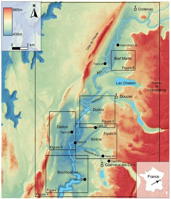
Figure 1.
Digital elevation map of the study area in eastern France, showing the Ain valley and its tributaries. The anticlinal fold of the Côte de l’Heute and the Champagnole plateau (red colors) are situated respectively west and east of the Ain valley (green and blue colors). Black boxes and figure numbers represent the location of figures mentioned later on in the text.
The study area is part of the Plateau Jura, characterized by subhorizontal strata and isolated folds [25]. To the east, the Jura region is characterized by a NE-SW oriented fold and thrust belt that was formed in the Miocene and Pliocene [27]. The study area consists of Middle and Upper Jurassic limestones and marls, that dip slightly to the east [25]. Differential erosion of the limestones and marls since the Pliocene has resulted in cuesta-like relief of the Côte de l’Heute (~650–750 m a.s.l.) and the Plateau de Champagnole (~600–850 m a.s.l.) (Figure 1). The Ain valley is underlain by Upper Jurassic Oxfordian marls. Therefore, the north-south orientation of the Ain valley is tectonically and lithologically controlled by the folding and eastward tilting of the Jurassic rocks [25].
The study area was glaciated during the second last (Riss/Saalian; circa 150 ka) and last (Würm/Weichselian; circa 20 ka) glacials by a separate Jura ice cap, that co-existed west of the Alpine ice cap [25,28]. The morphology and lithology of the Ain valley fill is especially determined by the last glacial (Würm) when the area was situated at the western limit of the ice cap [25,26]. Little is known about the presence and lithology of pre-glacial valley deposits, since they are covered by glacial and glacio-lacustrine sediments [29]. The maximum extent of the Würm glaciation occurred around 18.5 ka BP [30,31]. Age control on the maximum ice extent and ice retreat is partly based on correlation of morainic ridges with the well dated ice-core record [32]. However, direct dating and absolute dates of the glacial (moraines) and proglacial (delta, lacustrine) sediments are lacking. All detrital sediments are derived from Jurassic and Cretaceous carbonate rocks. Siliciclastic bedrock and sediments are not present in the study area. Luminescence-dating attempts, by dissolving the carbonates and extracting minor amounts of quartz, were not successful. The ages were strongly over-estimated, probably because of poor bleaching. Radiocarbon dating of the glacial sediments is impossible, due to the absence of vegetation and organic material in the sediments.
During the Würm glacial maximum, ice advanced into the Ain valley from the southeast at the location of the Chalain, Hérisson and Drouvenant tributary valleys (Figure 1). Therefore, terminal moraine complexes are present along the eastern margin of the Ain valley [25]. A glacier lobe south of the study area, near Orgelet, blocked the Ain drainage and the Ain valley was filled by a proglacial lake at 520 m a.s.l., in which up to 40 m thick, glacio-lacustrine, varved sediments were deposited [25,30,31,32]. The lifetime of the proglacial lake, based on varve counting, was estimated at c. 2500 years [25,31,33]. Coarse-grained, Gilbert-type deltas formed along the margins of the proglacial lake [25,26].
During the first ice-recessional phase, shortly after the glacial maximum of 18.5 ka BP, the Jura ice cap retreated. The recessional moraines of Doucier and Cogna were formed and the large proglacial lake in the Ain valley (520 m a.s.l.) rapidly drained [32]. Catastrophic outburst flooding may have occurred during lake drainage, since no falling-stage deltas have been found [26], comparable to conditions along the margin of the Scandinavian ice sheet in Germany [34]. Lake drainage and associated rapid base-level fall, caused the initiation of a new channel network on the former lake floor. Initial incision occurred of the high-stand deltas and terminal moraine complexes by the Ain and its tributaries with simultaneous deposition of a fluvial gravel sheet (highest terrace) on the former lake floor in front of the deltas and moraine complexes [26]. Ongoing fluvial incision by the Ain, combined with lateral migration, resulted in the formation of an unpaired terrace staircase in the glacio-lacustrine deposits (Figure 1, blue colors) [26,35]. The youngest Holocene terrace and floodplain have been dated by radiocarbon dating and pollen analysis (Section 4.1.4). The dates indicate that channel network initiation and most of the incision already occurred during the late Würm and early Holocene. According to Buoncristiani and Campy [31] the initial incision was rapid, exponentially decreasing over time.
Following the deglaciation, residual lakes in the tributary valleys (Lac Chalain, Lac Chambly, Lac Clairvaux) and on the Plateau de Champagnole were filled with autogenic lake marls, which contain a final Würm Late Pleniglacial, Late Glacial and Holocene archive of climate and vegetation changes [36]. The age of the lake infill shows that the region was already completely deglaciated before the onset of the Late Glacial (circa 15 ka cal BP). Therefore, all glacial and proglacial sediments, and initiation of the new channel network, predate the infill of the lakes and are older than 15 ka.
3. Methods
The study area was investigated and mapped for its last glacial and Holocene geomorphological and geological development for more than 30 years by the Vrije Universiteit Amsterdam. Previously, mapping was performed by using topographic maps (IGN 1:25,000 sheets Champagnole 3326ET, Saint-Claude 3327OT, Lons-le-Saunier 3226ET, St-Amour 3227OT) and aerial photographs. Since 2015 a high-resolution digital elevation model (https://geoservices.ign.fr/rgealti; accessed on 28 April 2025) and digital topographic maps were used. Prior to the fieldwork, topographic maps, aerial photographs and the digital elevation model were studied and morphographic maps were made on which concavities, convexities, crests, slopes and plains were indicated. During the field work, locality, elevation, morphology (concavity, convexity, slope angle, crest) were described (on paper, later on iPads) as well as, sediment texture and admixtures, sorting, roundness, sedimentary bedding and current direction (direction and angle of dip), color, carbonate content and (minimal) thickness of the deposits from sediment cores and exposures. The location of the observation points was selected based on the previous morphographic analysis. Observations were made in natural and artificial exposures along rivers, ditches and road cuts. Additional hand drilling completed this information where exposures were not available. The Edelman corer was used for unsaturated sediments. The gouge (3 cm diameter) was used for saturated clay and organic sediments especially along lakes (Lac Chalain, Lac Clairvaux, Lac Chambly). Grain size of the sediments was based on field estimates using the Dutch standard for grain-size classification (NEN 5104). Sand fractions in the range 50–2000 µm were determined with a sand grain-size ruler. Sorting of the sediments was qualitatively established. Well-sorted sediments contain one grain size class (e.g., sand); moderately sorted sediment consists of two classes (gravel and sand) and poorly sorted sediment has three or more classes (e.g., gravel, sand, silt, clay). Four gravel roundness classes loosely based on Powers [37] were distinguished (angular: gravel particles with sharp edges, subangular with rounded edges, subrounded with convex sides and rounded edges, rounded with rounded sides and edges). Sedimentary bedding was described following Miall [38]. Color was determined using the Munsell Color Chart. Carbonate content was established with the aid of 10% HCl. Color and carbonate content were determined in order to distinguish carbonate-rich parent materials (mostly 2.5Y7/4, pale yellow) from decalcified soil and colluvial material (mostly 10YR4/4, dark yellowish brown). Based on the geomorphological position and lithological characteristics of the sediment (grain size, sorting, roundness, bedding type) the depositional environment was interpreted [39]. The morphographic information and genetic interpretation of all the observation points has been combined into a valley wide morphogenetic map, that shows the units formed during the glacial maximum, the deglaciation and the Holocene interglacial. The morphogenetic map is the base for the present study on river channel establishment after drainage of the glacial lake. Geological cross sections over tributary catchments of the Ain were made to illustrate the subsurface lithology. The rationale for the cross section locations and orientation was to cover the morphology and lithological variability as much as possible. Observation points up to 250 m from the cross section line are indicated above the cross sections. The topography of the cross sections has been generalized. The cross sections are presented together with digital elevation images of the tributary catchments to demonstrate the relation between the location of the river channels, topography and subsurface lithology.
4. Results
4.1. Lithological Description and Interpretation of the Ain Valley Fill Sediments
All glacial and post-glacial sediments are rich in carbonate, since they consist almost exclusively of detrital material derived from the Jurassic and Cretaceous carbonate bedrock in the Ain catchment. Major exposures that show most of the Würm valley fill were studied along cut banks of the Ain river (Chatillon, slump Rozet; Monnet-la-Ville, slump Tilleul; Crotenay, slump Maison du Bois) and along the Drouvenant tributary (Clairvaux-les-Lacs, slump les Forges) (Figure 2). The lithological characteristics of the sedimentary units and their depositional environment are presented in Figure 3. The sedimentary characteristics and their environmental interpretation are combined to increase the readability of the following paragraphs. The morphogenetic map of the Ain valley is presented in Figure 4. Only the major morphogenetic units of large areal extent have been indicated (morainic ridges, high-stand deltas, glacio-lacustrine deposits and subaquatic moraines, lake drainage gravel sheet, terraces and floodplains). Minor occurrences of colluvial and hillslope deposits have not been indicated in Figure 4 for scale reasons. Interglacial lake marl deposits in the tributary valleys have not been depicted because they are outside the focus of this study.
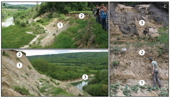
Figure 2.
Major exposures along the Ain and Drouvenant that show the stratigraphy of the Ain valley fill (see Figure 1 for location). (A) Glaciolacustrine deposits, 20 m thick (1) are overlain by subaquatic moraines, 5 m thick (2) (site Roset, cut bank Ain river, total height circa 35 m, basal part not visible; 4.5 km northeast of Chatillon; coordinates 46.6922881; 5.7631039); (B) Glaciolacustrine deposits, 15 m thick (1) are overlain by the highest terrace, 2 m thick (2) and lowest terrace, 3 m thick (3) (site Tilleul, cut bank Ain river, total height circa 30 m, basal part not visible; 1.2 km southwest of Monnet-la-Ville; coordinates 46.7139332; 5.7813010); (C) Fluvioglacial (delta) deposits, >1.5 m (1) are overlain by moraine (basal till, 1.5 m, note large boulder) (2) and delta deposits; >5 m, black ‘curtains’ are root mats (3) (site les Forges, cut bank Drouvenant river, 1.3 km north of Clairvaux-les-Lacs; coordinates 46.5868345; 5.7483263).
4.1.1. Morainic Deposits
The morainic deposits have been observed in ridges (terminal and recessional moraines) and slightly sloping plains (subaquatic moraines). The ridge sediments are massive and consist of a poorly sorted mixture of gravel, sand, silt and clay (Figure 3A) [39]. The grain size of the sediment is always heterogeneous, but the gravel to sand to silt ratio is different at different localities. Most of the gravel clasts are subangular, but roundness is variable. The terminal morainic ridges of the Drouvenant, Hérisson and Ain valleys (Figure 4) are dominated by sand and gravel and contain more subrounded and even some rounded gravel clasts. The terminal morainic ridges west of Chalain and near Baresia are dominated by silt and clay and contain more subangular to angular clasts. These differences in grain size and roundness can be explained by the position of the ridges with respect to former drainage channels. The glacial lobes flowing through the river valleys (Drouvenant, Hérisson and Ain) probably eroded pre-glacial and pro-glacial fluvial sandy and gravelly, more rounded sediments. The glacial lobes of Chalain and Baresia, that protruded further into the Ain valley (Figure 4), eroded previously deposited glacio-lacustrine silts and clay (Figure 2A and Figure 7) enlarging the fine-grained component in the morainic ridge deposits.
The subaquatic moraines consist of silt and clay with low gravel content (5–20%) (Figure 3B). They have a comparable lithological composition as the morainic ridges, but gravel and sand content is lower. They resemble glacio-lacustrine deposits, but the subaquatic moraines are massive and lack any lamination. They are found northwest and west of the morainic ridges of Baresia and Chalain respectively, on a slightly sloping plain (1–2%) dipping away from the ridges (Figure 4). The sediments grade laterally, without a morphological break, into the laminated glacio-lacustrine deposits. The sediments are interpreted as subaquatic moraines because of their elevation (circa 480–500 m a.s.l.) with respect to the glacial lake level (520 m a.s.l.), morphological position in front of morainic ridges and lateral continuation into the laminated glacio-lacustrine deposits [25,26,39]. The fine-grained lithology can be explained by erosion and incorporation of underlying fine-grained glacio-lacustrine sediments by the ice lobes of Baresia and Chalain, that expanded far into the lake in the final stage of maximum glaciation [25] (Figure 2A and Figure 3B). The massive character of the subaquatic moraines points to gravitational mass movements of water-saturated glacio-lacustrine sediments and morainic material in front of the morainic ridges.
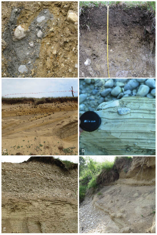
Figure 3.
Sediment characteristics of the major lithogenetic units in the Ain valley (see Figure 1 for location). (A) Poorly sorted, massive, morainic ridge deposits; grey color is reduced; brown color is oxidized sediment (frame is 0.8 m high, location 0.5 km east of Cogna; coordinates 46.5805310; 5.7639488); (B) Poorly sorted, massive, clay-rich subaquatic morainic deposits. Top 20 cm is the dark-colored Ah-soil horizon. Directly below the base of the pit well-laminated, glacio-lacustrine sediment was found (frame is 0.8 m, location 1.5 km northeast of Baresia; coordinates 46.5601167; 5.7215776); (C) Moderately sorted, gravelly coarse sand and medium silty sand, in slightly inclined delta topsets (1 m) and large-scale cross-bedded foresets (3 m). Current direction is to the left, southwest (site Carrières des Lacs, location 1.1 km southwest of Charcier; coordinates 46.6200666; 5.7409636); (D) Well-sorted, horizontally laminated, silt beds (light gray) and massive clay laminae (dark gray) in glacio-lacustrine sediments. Circa nine silt-clay (annual varve) couplets are present. Dropstone occurs in the silt bed and deforms the underlying clay-lamina (location 0.9 km south of Blye; coordinates 46.6147551; 5.7027116); (E) Moderately sorted, subrounded gravel and coarse sand of the highest terrace (2 m) overlying well-laminated glacio-lacustrine clay and silt deposits (>2 m) (site Tilleul, cut bank Ain river, 1.2 km southwest of Monnet-la-Ville; coordinates 46.7139332; 5.7813010); (F) Massive, sandy loam, floodplain deposits (1 m) overlying subrounded, gravel and coarse sand, channel bed and bar deposits (>1 m) (cut bank Ain river, 1.9 km southwest of Charézier; coordinates 46.6039557; 5.7054622).
4.1.2. Delta Deposits
The high-stand deltas consist of moderately sorted sand and gravel (Figure 3C). The gravel components are mostly subangular to subrounded. The deltas north of Monnet-la-Ville (Figure 4: gravel pit Combe Robert, pit Crotenay) are relatively thin (circa 10 to 20 m) and dominated by gravel with horizontal and low-angle cross bedding [26]. The deltas south of Monnet-la-Ville are thicker (up to 40 m near pit Largillay) and characterized by sand and gravel with large-scale, steeply dipping (20–25 degrees) cross bedding (Figure 3C). The sediments reveal an overall coarsening-upward trend from silt and fine sand at the base (incorporated in the glacio-lacustrine deposits), to sand and gravel and gravel at the top. The sedimentary succession indicates fluvial progradation into the glacial lake and coeval deposition of fluvial sand and gravel and glacio-lacustrine clay and silt. The deposits are interpreted as Gilbert-type deltas with topset and foreset beds [25,26,39]. The different bedding types north and south of Monnet-la-Ville are explained by differences in water depth. The Ain valley glacial lake was more shallow in the north (less than 20 m deep) than in the south (up to 60 m in the final stage near Pont-de-Poitte) based on the elevation difference between lake sediments and the delta topset-foreset break at 520 m (=lake level). The greater water depth in the south favors the gravitational deposition of sand and gravel on the delta front, forming steeply inclined foreset beds (Figure 3C). Shallow water hampers gravitational sliding and slumping and horizontal to low-angle cross bedding is formed in fluvial channel environments [26].
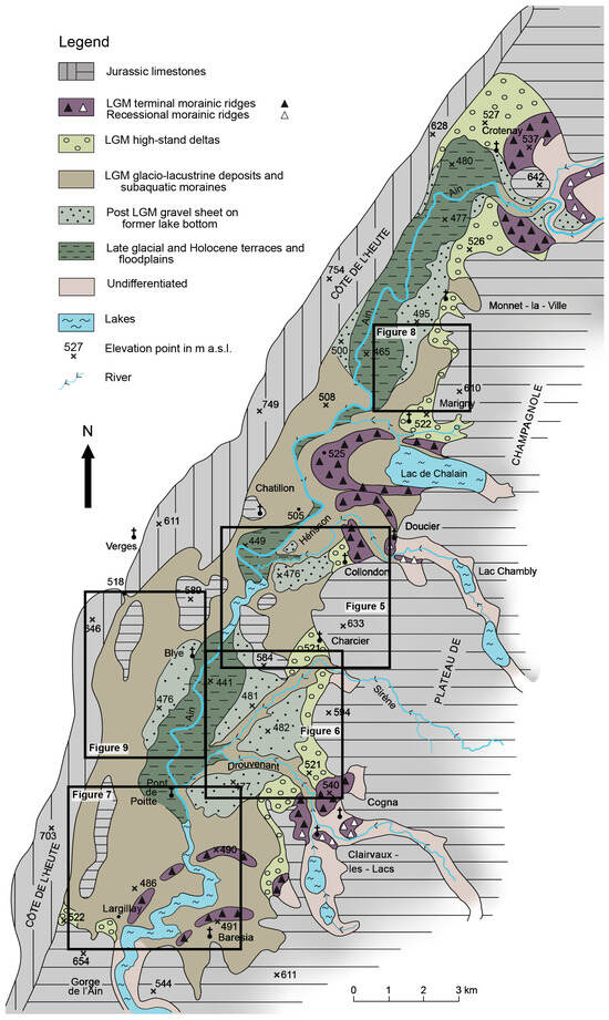
Figure 4.
Lithogenetic map of the Würm glacial and post-glacial deposits in the Ain valley. Coarse-grained moraines and Gilbert-type deltas occur in the east and glacio-lacustrine and younger terrace deposits in the center. The deposits within the tributary valleys are undifferentiated. Black boxes and figure numbers represent the location of figures mentioned later on in the text.
4.1.3. Glacio-Lacustrine Deposits
Glacio-lacustrine deposits consist of well-sorted silt and clay with well-developed horizontal lamination (Figure 3D). The sediments are characterized by a regular repetition of cm-scale, horizontally bedded, light gray (2.5Y7/2) silt beds and mm-scale, massive, greenish gray (5Y6/2) clay laminae. Locally, small-scale current ripples of fine sand and involutions have been observed [26] (location Chatillon, Bief de la Courtine at road bridge of departmental road D39). Isolated pebbles are locally found in the laminated sediments (Figure 3D). The fine-grained texture of the sediments indicates a low-energy lacustrine depositional environment. The silt-clay couplets have been interpreted as glacio-lacustrine annual varves [25,26,31,32]. The horizontal lamination in the silt beds is explained by distal turbidite deposition (Bouma D interval) generated from the delta fronts at the eastern margin of the lake during summer melt-water discharge (Figure 4) [39]. The massive clay laminae reflect deposition from suspension of the finest fraction (Bouma E interval) during winter when the lake was probably frozen. Based on varve counting, the duration of glacio-lacustrine deposition was estimated between 800 and 2500 year [25,31,32,40]. Isolated pebbles in the laminated sediments are interpreted as ice-rafted debris or drop stones from melting ice bergs (Figure 3D). The ice bergs probably originated from the ice lobes at Baresia (and possibly Chalain), that protruded far into the lake (Figure 4). The morainic ridges at Baresia have an elevation of circa 490 m a.s.l., while water level of the glacial lake was at 520 m, enabling ice-calving at the glacier front [39].
4.1.4. Lake-Drainage Gravel Sheet, Terrace and Floodplain Deposits
The gravel sheet (highest terrace), that formed on the former lake floor following lake drainage, and younger terrace sediments (Figure 4) consist of moderately sorted, coarse sand and gravel (Figure 3E). The gravel is mostly subangular to subrounded with increasing roundness in the younger terraces and floodplain. The deposits of the gravel sheets and terraces are mostly 1 to 3 m thick and erosively overlie the glacio-lacustrine sediments (Figure 3E) [26]. Horizontal and low-angle cross bedding is dominant, indicating deposition in shallow channels, probably by braided or gravel-bed meandering rivers [39].
The gravel-sheets form extensive plains overlying the glacio-lacustrine sediments (Figure 4). They are interpreted as braided river deposits, that formed shortly after lake drainage and associated base-level fall. The gravel sheets represent outwash plains related to the recessional moraines of Doucier, Cogna and Crotenay, that formed during the first phase of ice retreat following the glacial maximum (Figure 4). Lake drainage was probably short lived or even catastrophic since no deltas have been found lower than 520 m. The abrupt base-level lowering resulted in initial fluvial incision of the Gilbert-type deltas and moraine complexes along the eastern margin of the Ain valley, in order to restore the longitudinal gradients of the rivers. Simultaneously, extensive fluvial deposition occurred in front of the delta complexes. Topographic gradients of the gravel sheets indicate deposition by the melt-water fed precursors of the Drouvenant (northwest of Cogna, 7–9 m/km), Sirène (southwest of Charcier, 4 m/km), Hérisson (west of Collondon, 7 m/km) and Ain rivers (west of Monnet-la-Ville, south of Blye, 3 m/km) (Figure 4).
The terraces, that formed after the gravel sheet deposition, are mostly unpaired and occur predominantly along the Ain river course (Figure 4). The tributaries of the Ain are dominated by incision. The terraces are best developed and preserved in former depressions of the glacial lake floor, south of Crotenay, south of Chatillon and north of Pont-de-Poitte (Figure 4) [26]. The unpaired terraces formed as a result of ongoing incision, by the base-level lowering due to former glacial lake drainage, in combination with lateral migration [26]. Concave scours along terrace scarps, crop marks and residual channels indicate terrace formation by a meandering system. Incision of the Ain and tributaries in the unconsolidated sediments locally stopped due to emerging bedrock outcrops in the channel bed resulting in the formation of knick-points in the channel gradient (in the Ain river at the Pont-de-Poitte bridge and at the barrage east of Blye; in the Drouvenant at bridge in the departmental road D27) [26]. A radiocarbon date of 6130 ± 90 BP [25] and interglacial pollen assemblages [26] indicate that post-glacial incision and terrace formation exponentially decreased during the Late Glacial and early Holocene.
The floodplain sediments consist of moderately sorted, subrounded, 1–2 m thick sand and gravel (Figure 3F). In contrast to the terrace and gravel sheet deposits, the coarse-grained sediments are overlain by a yellowish brown (10YR6/4), massive, 1–2 m thick, sandy loam with snails (fragments) and charcoal (Figure 3F). The succession is fining-upward, however, the transition of sand and gravel to loam is mostly rapid. The morphology of the floodplain with ridges and swales and residual channels and the sedimentary sequence indicate deposition by a gravel-bed meandering system [41]. The fine-grained upper layer can be explained by land use changes and deforestation in the middle and late Holocene [42]. The region is famous for its Neolithic and Bronze age occupation [43]. Increased agricultural activity and soil erosion may have released the fine-grained weathering residue of carbonate rocks in the Ain catchment and glacio-lacustrine sediments in the Ain valley.
4.2. Fluvial Channel Location and Sub-Surface Lithology
The location of the Ain river and its tributaries in the Ain valley are depicted in Figure 1. Lithogenetic cross sections were made over several tributaries to investigate the subsoil lithological characteristics that might explain the initiation and location of the river channels after glacial-lake drainage. The selection of the river systems and cross sections is based on the geomorphology, which is related to the position of the ice-front and sediment input in the glacial lake, and lithological characteristics of the Ain valley fill (terrace gravel versus glacio-lacustrine clay). The Dudon, Sirène and Bourbouillon systems are located on the glacio-lacustrine sediments in front of coarse-grained Gilbert-type deltas and a subaqueous moraine ridge. Bief Martin and Daillon are located on the glacio-lacustrine sediments, partially covered by terrace gravels (Figure 4).
4.2.1. Ain
The Ain has an east-west flow direction east of Crotenay (Figure 1). Southeast of Crotenay the Ain cuts deeply into morainic deposits, coarse-grained delta deposits and underlying glacio-lacustrine clay and silt (Figure 4) [26]. South of Crotenay the flow direction changes to the south through the Ain valley. The river is generally not in the center of the valley, but occupies a course in the western part of the valley. The Ain has deeply incised in glacio-lacustrine deposits, forming extensive terraces and floodplains (Figure 2A,B, Figure 3E and Figure 4). Carbonate bedrock is close to or in the river bed, and the river flows on the east-dipping carbonate slope of the Côte de l’Heute [29]. West of Lac Chalain, the Ain shows a characteristic bend around the flat-topped, fine-grained morainic ridges (Figure 4). South of Chatillon the Ain flows between residual carbonate hills and bedrock is exposed in the river bed at the barrage east of Blye. Between Blye and Pont-de-Poitte the Ain created a wide terrace staircase and floodplain (Figure 3F) in glacio-lacustrine deposits (Figure 3D) (Figure 4). At the Pont-de-Poitte bridge, the Ain incises into bedrock and a water-fall existed prior to the development of the Vouglans artificial lake. South of Pont-de-Poitte (at 425 m a.s.l.) the Ain has incised deeply in subaqueous fine-grained morainic deposits (Figure 3B) and underlying glacio-lacustrine sediments before entering the bedrock gorge (Gorge d’ Ain) presently filled by the artificial Vouglans lake.
4.2.2. Dudon
The Dudon river is situated between the villages Charcier and Collondon (Figure 5). The east to west flowing river emerges from a karstic source at circa 500 m a.s.l. at the foot of the Plateau de Champagnole and flows into the Ain at 445 m.
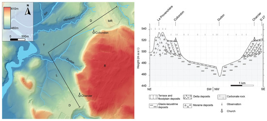
Figure 5.
Digital elevation map and geological cross section over the Dudon catchment (see Figure 1 for location). The Dudon is located in the depression formed by the sloping, distal bottomsets of the Charcier and Collondon deltas. B = carbonate bedrock; MR = morainic ridges; D = deltas; L = glacio-lacustrine deposits; T = terrace. Observation points are indicated by small arrows above the cross section.
The lithogenetic cross section has a general north-south orientation with a break in orientation at the Dudon river. The elevation varies from 535 m a.s.l. on the terminal morainic ridges of la Provenchère and 520 m at the delta topset to foreset slope break at Charcier (Figure 3C) and Collondon. In front of both deltas the elevation of the top of the delta bottomsets and glacio-lacustrine clays and silts decreases from about 495 m to 475 m a.s.l. near the Dudon river (Figure 5). The glacio-lacustrine deposits north of the Dudon are overlain by a thin (1–2 m) gravel sheet. This gravel sheet was deposited by the Hérisson as an outwash plain related to the recessional moraines of Doucier, shortly after the first ice retreat and drainage of the glacial lake (Figure 4) [26]. The Dudon initiated in the lowest area of the glacio-lacustrine plain (i.e., former lake floor) and then incised to its present elevation at circa 460 m a.s.l. The Dudon catchment shows a dendritic network south of the main channel in the glacio-lacustrine deposits (Figure 5: code L). Such a network is absent north of the main channel where the glacio-lacustrine deposits are covered by the gravel sheet (Figure 5: code T).
4.2.3. Sirène
The northeast to southwest flowing Sirène is a tributary of the Ain which debouches on the Plateau de Champagnole near Bonlieu at an altitude of 785 m a.s.l. The river incises deeply at the border of the Plateau de Champagnole near Charcier and flows in a southwesterly direction to the Ain at 435 m a.s.l. (Figure 6).
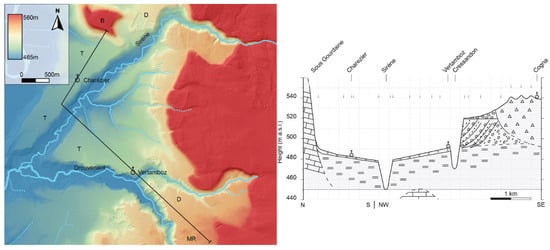
The generally south–north cross section is situated between Cogna-Vertamboz and Sous Gourdaine (Charcier), perpendicular to the morphology, with a break in orientation at the Sirène river. Carbonate bedrock is exposed at the Sous Gourdaine hill (Figure 6: code B) and in the subsurface at circa 450 m, projected from the exposure at the bridge crossing the Drouvenant river (road number D27). In the southeast the terminal morainic ridges west of Cogna are present at circa 540 m (Figure 6: code MR). In front of the ridges the gravel and sand delta complex of Vertamboz is present at 530 m dipping to 520 m a.s.l. at the delta topset-foreset break (Figure 6: code D). Delta bottomsets and glacio-lacustrine clay and silt deposits are present below and in front of the delta complex and show a gentle northward dip from 495 to 480 m a.s.l. near the Sirène. North of the Sirène the glacio-lacustrine deposits increase in elevation to 490 m at the foot of the Sous Gourdaine bed rock hill and the delta complex of Charcier (Figure 3C and Figure 6: code B and D). The dip of the glacio-lacustrine deposits and location of the deltas indicate that the glacio-lacustrine deposits originated from two delta sources in the southeast (Vertamboz) and in the northeast (Charcier). The glacio-lacustrine deposits are covered on both sides of the Sirène by the highest, 1 to 4 m thick, gravel terrace (Figure 4 and Figure 6: T). The northwestern and southwestern dip of the extensive gravel sheet surfaces indicates deposition by the palaeo-Drouvenant and Sirène respectively. The gravel sheets represent outwash plains related to the first phase of ice retreat (recessional moraines of Cogna) shortly after the rapid or catastrophic lake drainage when the ice dam in the south collapsed (Figure 4) [26]. Later the river incised to its present position at circa 450 m a.s.l.
4.2.4. Bourbouillon
In contrast to the southern river flow direction of the Ain, the Bourbouillon tributary flows to the north (Figure 7). It has its headwaters near Largillay-Marsonnay at circa 485 m a.s.l. (Figure 4). The flow direction changes sharply near Blaisnay where the river turns to the east and joins the Ain near Pont-de-Poitte at 435 m.
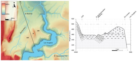
The south to north cross section is almost parallel to the river and runs from Lac Vouglans in the south (425 m a.s.l.) to the bedrock outcrop along the national road (number N78) between Thuron and Buron at 465 to 500 m a.s.l. (Figure 7). The Jurassic carbonate rocks show an eastsoutheast dip (circa 10°) in the west and near Blaisnay. The bedrock is overlain by glacio-lacustrine clays and silts with the top (former lake bottom) at 460 to 465 m a.s.l. In the southern part of the cross section the glacio-lacustrine deposits are covered by fine-grained subaquatic moraines (at 490 m) (Figure 7), that have been deposited by an ice lobe advancing into the glacial lake from the southeast near Baresia (Figure 3B and Figure 4).
4.2.5. Bief Martin
The east to west flowing Bief Martin debouches in several karstic sources at circa 530 m a.s.l. at the foot of the Plateau de Champagnole and flows into the Ain at 460 m (Figure 8). The eastern part of the catchment shows a dendritic drainage network while the western part (west of road number D27) is a single channel straight course.
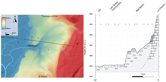
Figure 8.
Digital elevation map and cross section over the Bief Martin catchment (see Figure 1 for location; Figure 5 for legend). Bief Martin has a dendritic network in the east and eroded more intensively into the fine-grained glacio-lacustrine deposits (L) in comparison to the coarse-grained terrace deposits (T). F = floodplain.
The east-west cross section is located north of Marigny, perpendicular to the morphology. The elevation ranges from 560 m a.s.l. at the border of the Plateau de Champagnole (Figure 8: code B) to 460 m at the Ain river. On the eastern side of the transect, a small delta (D) is present at 520 m. Glacio-lacustrine deposits (L), west of the delta, dip from 505 to 490 m. These glacio-lacustrine deposits are covered by the highest, north-south oriented, thin (1–3 m) gravel terraces (code T) at circa 495 and 490 m, dipping south. They were formed, shortly after glacial lake drainage, by the precursor of the Ain, that was fed by melt-water related to the first recessional moraine east of Crotenay, and by small tributaries draining the plateau in the east (Figure 4) [26]. Following the formation of the highest terrace, deep erosion and lateral migration by the Ain resulted in the formation of the alluvial plain at 460 m a.s.l. (Figure 8: code F).
4.2.6. Daillon
The Daillon, which flows from north to south, debouches in the wide plain at circa 470 m a.s.l., west of bedrock hill Grand Mont-Lyon. The Daillon, west of Blye and Mesnois, flows remarkably parallel to the Ain and joins the Ain south of Mesnois at 437 m a.s.l. (Figure 9).
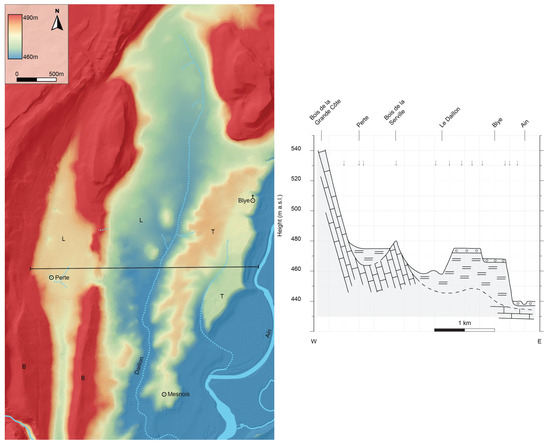
Figure 9.
Digital elevation map and cross section over the Daillon catchment (see Figure 1 for location; Figure 5 for legend). The Daillon has eroded preferentially into the fine-grained glacio-lacustrine deposits (code L) in comparison to the coarse-grained terrace deposits (T) resulting in relief inversion.
The west-east cross section shows the eastward dipping carbonate rocks of the Côte de l’Heute (Figure 9: code B). Note that the dip is not the true dip due to vertical exaggeration of the profile. The subsurface topography of the bedrock is partly unknown, but carbonate rocks crop out in the sink hole (perte) in the west, Bois de la Serville and in the Ain channel bed near the Barrage de Blye. The carbonate bedrock is overlain by glacio-lacustrine deposits (code L) up to 475 m a.s.l. Near Blye and Mesnois the highest, thin gravel terraces occur at circa 475 and 470 m (Figure 9: code T). They dip to the south (3 m/km), indicating formation by the Ain river, during and shortly after glacial lake drainage (Figure 4). The Daillon has incised especially into the fine-grained glacio-lacustrine deposits (L), that occur west of the coarse-grained highest Ain terraces (Figure 9: code T). Later the Ain eroded deeply east of the terraces into glacio-lacustrine deposits, forming the present-day floodplain at 440 m a.s.l.
5. Interpretation and Discussion
Most drainage systems have a long-term evolution related to tectonics [1,2,3,4], climatic changes [5,6,7,8,9,10], glaciation [11,12,13,14,23,24] and river capturing [15]. Therefore, controlling factors of fluvial channel initiation and location are often unknown. Geologically young surfaces or experimental set ups circumvent this problem [19,21]. The post-glacial Ain valley in eastern France (Figure 1) provides an opportunity to establish the forcing factors of fluvial channel initiation. During the last glacial maximum (circa 20 ka) the Ain valley was filled with morainic deposits, coarse-grained deltas and fine-grained glacio-lacustrine deposits [25,26]. Extensive morphogenetic mapping (see Section 4.1) has provided a detailed picture of the morphology, lithology of the sediments and sedimentary architecture of the valley fill (Figure 4). The role of topography of the former lake floor and diverse lithology of the glacial valley fill on post-glacial fluvial channel initiation are discussed below.
5.1. Channel Development Related to Topography
The Ain is located in the central and western part of the Ain valley (Figure 1). The Jurassic carbonate rocks dip eastward in the Côte de l’Heute (Figure 7 and Figure 9) and are subhorizontal along the western margin of the Plateau de Champagnole [25]. The cuesta-like relief suggests that the preglacial course of the river was probably situated along the eastern margin of the Ain valley, close to the cuesta front of the Plateau de Champagnole. Indeed, the glacial-age sediments reach maximum thickness along the eastern margin of the Ain valley as demonstrated by geophysical studies [31,33]. The present Ain course, therefore does not coincide with its preglacial course. This is demonstrated also by the presence of local bedrock sills and gradient knickpoints, near Pont-de-Navoy, Blye and Pont-de-Poitte, in the otherwise unconsolidated sediments of the present river bed. Because of the location of the Jura ice cap, east of the Ain valley, the incised preglacial course was probably buried by glacial deposits (moraine, delta, lacustrine) that filled the proglacial lake at 520 m a.s.l. (Figure 2, Figure 3 and Figure 4). The lake floor in the final stage of glacio-lacustrine deposition, was higher in the east (e.g., circa 490 m a.s.l. northwest of Charcier; 485 m at Vertamboz, Figure 5 and Figure 6) than in the west (e.g., circa 475 m a.s.l. west of Blye; 465 m near Blaisnay, Figure 7 and Figure 9). This elevation difference is likely due to higher sedimentation rates in the eastern part of the lake in closer proximity to the ice front, resulting in an asymmetrical valley fill [26]. After lake drainage, the Ain established a course in the western part of the Ain valley following the lowest areas of the former lake floor (Figure 1) and from there the river incised by headward erosion [35] until bedrock was reached at Pont-de-Poitte and Blye, forming knickpoints in the longitudinal river profile [26]. At some locations (Chalain and Baresia) ice lobes had protruded into the glacial lake and formed gently sloping subaqueous moraine ridges and after lake drainage the Ain was forced to flow around these higher topographic elements on the former lake floor (Figure 4). To summarize, the initiation and present-day course of the Ain is determined by the topography of the drained glacial lake floor, which in turn is related to more intense glacio-lacustrine and glacial deposition along the eastern margin of the glacial lake close to the glacier front (Figure 4).
The cross sections over the Dudon and Sirène valleys (Figure 5 and Figure 6) show that the rivers started to incise at locations where the glacio-lacustrine and overlying gravel deposits (highest terrace) occur at a relatively low elevation. This means that the initiation of the Dudon and Sirène rivers, after glacial lake drainage, is determined by the elevation of the fine-grained, glacio-lacustrine deposits on the former lake floor. Apparently, the lake floor was not completely levelled during glacio-lacustrine deposition. This differential lake floor topography can be related to the glacio-lacustrine sediment sources and transport directions, generally from the east along the Plateau de Champagnole where the ice cap was situated (Figure 4: terminal morainic ridges). The glacio-lacustrine deposits exposed in the Dudon valley originate from the delta complexes of Charcier in the southeast and Collondon in the northeast (Figure 5, code D). The glacio-lacustrine deposits in the Sirène valley originate from the delta complexes of Clairvaux-les-Lacs/Cogna in the southeast and Charcier in the northeast (Figure 6, code D). Coarse-grained sand and gravel was deposited at the lake margin by melt-water rivers that fed Gilbert-type deltas (Figure 3C) [25,26]. Fine-grained, suspended sediments were transported further into the lake and settled as glacio-lacustrine deposits (Figure 3D) [33]. The accumulation rates were likely higher in front of the deltas (proximal glacio-lacustrine deposition with thicker varves) in comparison to more distal lake positions (thinner varves), resulting in gentle slopes and elevation differences of the glacio-lacustrine deposits on the lake floor [39]. Thus, the initial location and later incision of the Dudon and Sirène are determined by elongated depressions on the former lake floor, where distal delta bottomsets of different deltas meet (Figure 5 and Figure 6). The initial location of the rivers can thus be explained by the glacio-lacustrine lake floor topography [19].
The Bourbouillon is situated in a depression between the subaqueous morainic deposits in the southeast at 490 m a.s.l. and the north-south oriented bedrock hills in the west (Figure 7). Intensive subaqueous moraine deposition (Figure 3B) was caused by an ice lobe that entered the lake from the southeast near Baresia [25] (Figure 4). This raised the lake bottom up to 490 m. More distal with respect to the ice front, glacio-lacustrine deposition occurred at 460 m a.s.l, which is the lowest point of the lake floor in the study area (Figure 7). Water depth during the final stage of glacio-lacustrine deposition at this location was 60 m, which is the greatest water depth in the Ain valley. Water level was at 520 m, based on delta topset to foreset transitions (Figure 3C). Therefore, the initiation and northern flow of the Bourbouillon can be explained by the topographic slope of the former lake floor. The sharp changes in flow direction around Blaisnay are related to the carbonate bedrock outcrop at this location (Figure 7).
5.2. Channel Development Related to Lithology
The cross sections across the Bief Martin and Daillon rivers show contrasting lithologies of coarse-grained, gravelly deposits (highest terrace) overlying fine-grained glacio-lacustrine sediments (Figure 3E, Figure 8 and Figure 9). The rivers have incised especially into the fine-grained deposits. The small catchment of the Bief Martin and its tributaries has eroded up to 10 m deep in glacio-lacustrine deposits (Figure 8, code L). The formation of the dendritic network and erosional depression east of the terraces can be explained by the impermeable glacio-lacustrine clay and silt deposits leading to more intense surface runoff and sheet-flow erosion [21]. In contrast, the single-channel river and localized erosion of the terraces (Figure 8, code T) can be explained by the highly permeable gravel deposits, that enhance infiltration, subsurface flow and seepage erosion at the gravel to clay contact [17]. According to Campy et al. [35], most of the incision of the fine-grained glacio-lacustrine deposits in the Ain valley occurred between 18 and 6 ka. Incision started shortly after glacial lake drainage and decreased exponentially over time. This might imply that the clays and silts were still soft and unconsolidated, enhancing erosion. In addition, the well-developed laminations of contrasting lithology (clay versus silt) may have promoted slumping and mass movement. Massive and consolidated clay and silt deposits, on the other hand, are very cohesive and resistant against erosion as demonstrated by the formation of Neogene and Quaternary clay cuestas in northern Belgium [44,45].
The Daillon cross section shows that the former lake floor was at circa 475 m a.s.l., as indicated by the elevation of the glacio-lacustrine plain west of Bois de la Serville (Figure 9). This flat plain was not affected by later erosion, since surface flow (brooks) is absent and drainage occurs subsurface along the sinkhole (perte) (Figure 9). Therefore, water depth in the final stage of the lake was 45 m, since water level was at 520 m. Following lake drainage gravel was deposited by the Ain on top of the glacio-lacustrine sediments (Figure 3E and Figure 4). Gravel represents a palaeofloodplain and it must therefore have been deposited on the lowest parts of the drained lake floor. After deposition of the gravel by the Ain, the Daillon eroded up to 15 m of the fine-grained, glacio-lacustrine deposits, forming an elongated north-south depression, west of the high terraces (Figure 9, code T). The terraces are well preserved, although the margins have been eroded by small-scale, theatre-headed tributaries of the Daillon and Ain rivers. Apparently, the contrasting lithologies (gravel versus clay) on the former lake floor and associated differences in erodibility have caused relief inversion. The terrace gravel forms an erosion-resistant layer, since the gravel is highly permeable, promoting infiltration and reducing erosion by overland flow. The originally low-lying gravels now stand out as higher topographic elements (terraces) in the landscape (Figure 9, code T), while the originally higher, fine-grained sediments, west of the terraces, have been severely eroded by the Daillon (Figure 9, code L). Relief inversion by lithological-controlled differential erosion has been reported previously. The coarse-grained Quaternary terraces of the Allier river in central France occur as erosion-resistant river-parallel hills in the landscape. Oligocene marls are found in erosional depressions west of the Allier river terraces [46,47,48]. The Campine Plateau in northeastern Belgium, covered with Early Pleistocene Meuse and Rhine sand and gravel, stands out as a higher area as a result of stronger erosion of fine-grained Neogene deposits west of the Plateau [44,49,50].
The analysis of Bief Martin and Daillon highlights the importance of lithology on erosion and river channel initiation (Figure 8 and Figure 9). Fine-grained glacio-lacustrine deposits have low permeability and limited water infiltration capacity leading to Horton overland flow. Therefore, surface runoff and sheet-flow erosion are more important [17]. Sockness and Gran [21] (p. 599) conclude that ‘’overland flow channels erode greater volumes of sediment due to their extensive channelized area’’. The stronger erosion of the fine-grained deposits at Bief Martin and Daillon resulted in depressions with a dendritic drainage network, east and west of the Ain terraces respectively (Figure 8 and Figure 9). In contrast, the terrace gravels experienced little erosion by their high permeability and enhanced infiltration. This strongly limited overland flow and favored subsurface flow and seepage-driven erosion (sapping) at the gravel to clay contact at the borders of the terraces. This finding supports previous conclusions about the importance of substrate composition in drainage channel initiation [18,21,22].
In several locations small-scale, often parallel-oriented, drainage channels occur that cannot be explained by topographic or lithologic factors. Northeast-southwest oriented, up to 1 km long, parallel valleys occur northeast of Chatillon (location Sur Rozet) (Figure 1 and Figure 2A) and west and east of the Ain river near Blaisnay (Figure 7). These channels are incised in thin terrace gravel deposits overlying glacio-lacustrine sediments. The orientation of the valleys is similar to the strike of the geological structures (e.g., Côte de l’Heute) (Figure 1), suggesting a tectonic origin. However, the valleys were formed in unconsolidated glacial sediments, possibly indicating neotectonic activity.
6. Conclusions
Factors controlling the post-glacial initiation of fluvial channels on a former glacial lake floor in the Ain river valley in eastern France have been reconstructed. The region was partly glaciated during the Würm (Weichselian) glacial (circa 20 ka) and a large proglacial lake developed in the Ain valley. Extensive morphological and sedimentological mapping and lithogenetic interpretation of the valley fill sediments (moraine, deltaic, lacustrine) show that channel locations, after lake drainage, are determined by the lake floor topography and lithological composition and heterogeneity of the lake floor deposits.
The post-glacial course of the Ain river initiated along the deepest parts of the former glacial lake. The river is situated more westward than the pre-glacial course because the valley was filled asymmetrically due to higher sedimentation rates in the east, near the glacier front.
The initiation and location of the tributaries Dudon, Sirène and Bourbouillon are controlled by the topography of the drained lake floor. The tributaries initiated in elongated depressions, formed by slightly sloping, coalescing, distal delta bottomsets of Gilbert-type deltas, that filled the glacial lake from different directions (east and south). The initiation and location of the Bief Martin and Daillon tributaries are controlled by differences in lithology and grain size of the former lake floor. These tributaries initiated preferentially on fine-grained, glacio-lacustrine, low-permeability deposits, that limited water infiltration and increased surface erosion. Stronger and deeper erosion of the fine-grained, glacio-lacustrine sediments compared to coarse-grained, fluvial deposits resulted in relief inversion and terrace formation on the former lake floor.
Author Contributions
Conceptualization, C.K.; Methodology, C.K.; Software, O.V.; Formal analysis, C.K. and O.V.; Investigation, C.K.; Writing—review and editing, C.K. and O.V.; Visualization, O.V. All authors have read and agreed to the published version of the manuscript.
Funding
This research received no external funding.
Data Availability Statement
All data in this paper are available at the corresponding author upon reasonable request.
Acknowledgments
The observations have been made over a 30 year period of fieldwork by 2nd year students and staff members of the Earth Sciences department of the Vrije Universiteit, Amsterdam. We thank three anonymous reviewers for their valuable comments that improved the manuscript.
Conflicts of Interest
The authors declare no conflicts of interest.
References
- Van den Berg, M.W. Fluvial Sequences of the Maas: A 10 ma Record of Neotectonics and Climate Change at Various Time-Scales. Ph.D. Dissertation, Landbouw Universiteit Wageningen, Wageningen, The Netherlands, 1996; pp. 37–62. [Google Scholar]
- Westerhoff, W.E.; Kemna, H.A.; Boenigk, W. The confluence area of Rhine, Meuse, and Belgian rivers: Late Pliocene and Early Pleistocene fluvial history of the northern Lower Rhine Embayment. Neth. J. Geosci.-Geol. Mijnb. 2008, 87, 107–125. [Google Scholar] [CrossRef]
- Woolderink, H.A.G.; Cohen, K.M.; Kasse, C.; Kleinhans, M.G.; Van Balen, R.T. Patterns in river channel sinuosity of the Meuse, Roer and Rhine rivers in the Lower Rhine Embayment rift-system, are they tectonically forced? Geomorphology 2021, 375, 107550. [Google Scholar] [CrossRef]
- Seybold, H.; Berghuijs, W.R.; Prancevic, J.P.; Kirchner, J.W. Global dominance of tectonics over climate in shaping river longitudinal profiles. Nat. Geosci. 2021, 14, 503–507. [Google Scholar] [CrossRef]
- Busschers, F.S.; Kasse, C.; Van Balen, R.T.; Vandenberghe, J.; Cohen, K.M.; Weerts, H.J.T.; Wallinga, J.; Johns, C.; Cleveringa, P.; Bunnik, F.P.M. Late Pleistocene evolution of the Rhine-Meuse system in the southern North Sea basin: Imprints of climate change, sea-level oscillation and glacio-isostasy. Quat. Sci. Rev. 2007, 26, 3216–3248. [Google Scholar] [CrossRef]
- Nádor, A.; Thamó-Bozsó, E.; Magyari, Á.; Babinszki, E. Fluvial responses to tectonics and climate change during the Late Weichselian in the eastern part of the Pannonian Basin (Hungary). Sediment. Geol. 2007, 202, 174–192. [Google Scholar] [CrossRef]
- Gibbard, P.L.; Lewin, J. River incision and terrace formation in the Late Cenozoic of Europe. Tectonophysics 2009, 474, 41–55. [Google Scholar] [CrossRef]
- Van Huissteden, J.; Vandenberghe, J.; Gibbard, P.; Lewin, J. Periglacial rivers. In The Encyclopedia of Quaternary Science, 2nd ed.; Elias, S.A., Ed.; Elsevier: Amsterdam, The Netherlands, 2013; pp. 490–499. [Google Scholar]
- Kasse, C.; Van Balen, R.T.; Bohncke, S.J.P.; Wallinga, J.; Vreugdenhil, M. Climate and base-level controlled fluvial system change and incision during the last glacial–interglacial transition, Roer river, the Netherlands—Western Germany. Neth. J. Geosci.—Geol. Mijnb. 2017, 96, 71–92. [Google Scholar] [CrossRef]
- Hoek, W.Z.; Lammertsma, E.I.; Bohncke, S.J.P.; Bos, J.A.A.; Bunnik, F.; Kasse, C.; Schokker, J.; Westerhoff, W. Lateglacial and early Holocene vegetation development and fluvial system changes in the northern Meuse valley, the Netherlands: A review of palynological data. Neth. J. Geosci.—Geol. Mijnb. 2017, 96, 93–114. [Google Scholar] [CrossRef]
- Bridgland, D.R.; D’Olier, B. The Pleistocene evolution of the Thames and Rhine drainage systems in the southern North Sea Basin. In Island Britain: A Quaternary Perspective; Preece, R.C., Ed.; Geological Society Special Publication: Bath, UK, 1995; No. 96; pp. 27–45. [Google Scholar]
- Mangerud, J.; Jakobsson, M.; Alexanderson, H.; Astakhov, V.; Clarke, G.K.C.; Henriksen, M.; Hjort, C.; Krinner, G.; Lunkka, J.-P.; Möller, P.; et al. Ice-dammed lakes and rerouting of the drainage of northern Eurasia during the Last Glaciation. Quat. Sci. Rev. 2004, 23, 1313–1332. [Google Scholar] [CrossRef]
- Busschers, F.S.; Van Balen, R.T.; Cohen, K.M.; Kasse, C.; Weerts, H.J.T.; Wallinga, J.; Bunnik, F.P.M. Response of the Rhine-Meuse fluvial system to Saalian ice-sheet dynamics. Boreas 2008, 37, 377–398. [Google Scholar] [CrossRef]
- Peeters, J.; Busschers, F.S.; Stouthamer, E.; Bosch, J.H.A.; Van den Berg, M.W.; Wallinga, J.; Versendaal, A.J.; Bunnik, F.P.M.; Middelkoop, H. Sedimentary architecture and chronostratigraphy of a late Quaternary incised-valley fill: A case study of the late Middle and Late Pleistocene Rhine system in the Netherlands. Quat. Sci. Rev. 2016, 131, 211–236. [Google Scholar] [CrossRef]
- Cordier, S.; Frechen, M.; Harmand, D.; Beiner, M. Middle and Upper Pleistocene fluvial evolution of the Meurthe and Moselle valleys in the Paris Basin and the Rhenish Massif. Quaternaire 2005, 16, 201–215. [Google Scholar] [CrossRef]
- Schumm, S.A. Geomorphic thresholds and complex response of drainage systems. Fluv. Geomorphol. 1973, 6, 69–85. [Google Scholar]
- Dunne, T. Formation and controls of channel networks. Prog. Phys. Geogr. 1980, 4, 211–239. [Google Scholar] [CrossRef]
- Gomez, B.; Mullen, V.T. An experimental study of sapped drainage network development. Earth Surf. Process. Landf. 1992, 17, 465–476. [Google Scholar] [CrossRef]
- Pelletier, J.D. Drainage basin evolution in the Rainfall Erosion Facility: Dependence on initial conditions. Geomorphology 2003, 53, 183–196. [Google Scholar] [CrossRef]
- Kleinhans, M.G.; Schuurman, F.; Bakx, W.; Markies, H. Meandering channel dynamics in highly cohesive sediment on an intertidal mud flat in the Westerschelde estuary, the Netherlands. Geomorphology 2009, 105, 261–276. [Google Scholar] [CrossRef]
- Sockness, B.G.; Gran, K.B. An experimental study of drainage network development by surface and subsurface flow in low-gradient landscapes. Earth Surf. Dyn. 2022, 10, 581–603. [Google Scholar] [CrossRef]
- Morisawa, M. Development of drainage systems on an upraised lake floor. Am. J. Sci. 1964, 262, 340–354. [Google Scholar] [CrossRef]
- MacPherson, J. Raised shorelines and drainage evolution in the Montréal Lowland. Cah. Géographie Québec 1967, 11, 343–360. [Google Scholar] [CrossRef]
- Winsemann, J.; Alho, P.; Laamanen, L.; Goseberg, N.; Lang, J.; Klostermann, J. Flow dynamics, sedimentation and erosion of glacial lake outburst floods along the Middle Pleistocene Scandinavian Ice Sheet (northern central Europe). Boreas 2016, 45, 260–283. [Google Scholar] [CrossRef]
- Campy, M. Le Quaternaire Franc-Comtois: Essai Chronologique et Paléoclimatique. Ph.D. Thesis, University of Franche-Comté, Besançon, France, 1982; 575p. [Google Scholar]
- Kasse, C. Fluvial response to rapid high-amplitude lake-level changes during the Late Weichselian and early Holocene, Ain River valley, Jura, France. Boreas 2014, 43, 403–421. [Google Scholar] [CrossRef]
- Homberg, C.; Bergerat, F.; Philippe, Y.; Lacombe, O.; Angelier, J. Structural inheritance and Cenozoic stress fields in the Jura fold-and-thrust belt (France). Tectonophysics 2002, 357, 137–158. [Google Scholar] [CrossRef]
- Buoncristiani, J.F.; Campy, M. The palaeogeography of the last two glacial episodes in France: The Alps and Jura. In Quaternary Glaciations—Extent and Chronology; Ehlers, J., Gibbard, P.L., Eds.; Elsevier: Amsterdam, The Netherlands, 2004; pp. 101–106. [Google Scholar]
- Aalbersberg, G.; Kasse, C. A Pleniglacial fluvial deposit from the Combe d’Ain (Jura, France). Quaternaire 2003, 14, 97–103. [Google Scholar] [CrossRef]
- Campy, M.; Arn, R. The Jura glaciers: Palaeogeography in the Würmian circum-Alpine zone. Boreas 1991, 20, 17–27. [Google Scholar] [CrossRef]
- Buoncristiani, J.F.; Campy, M. Late Pleistocene detrital sediment yield of the Jura glacier, France. Quat. Res. 2001, 56, 51–61. [Google Scholar] [CrossRef]
- Buoncristiani, J.F.; Campy, M. Expansion and retreat of the Jura ice sheet (France) during the last glacial maximum. Sediment. Geol. 2004, 165, 253–264. [Google Scholar] [CrossRef]
- Buoncristiani, J.F. Production Sedimentaire Détritique des Systèmes Glaciaires. Quantification des Produits Stockés dans un lac Proglaciaire Durant la Dernière Glaciation: Exemple du lac de la Combe d’Ain (Jura, France). Ph.D. Thesis, University of Bourgogne, Dijon, France, 1997; 232p. [Google Scholar]
- Winsemann, J.; Brandes, C.; Polom, U. Response of a proglacial delta to rapid high-amplitude lake-level change: An integration of outcrop data and high-resolution shear wave seismics. Basin Res. 2011, 23, 22–52. [Google Scholar] [CrossRef]
- Campy, M.; Buoncristiani, J.F.; Bichet, V. Sediment yield from glacio-lacustrine calcareous deposits during the postglacial period in the Combe d’Ain (Jura, France). Earth Surf. Process. Landf. 1998, 23, 429–444. [Google Scholar] [CrossRef]
- Magny, M.; Aalbersberg, G.; Bégeot, C.; Benoit-Ruffaldi, P.; Bossuet, G.; Disnar, J.-R.; Heiri, O.; Laggoun-Defarge, F.; Mazier, F.; Millet, L.; et al. Environmental and climatic changes in the Jura Mountains (eastern France) during the Lateglacial-Holocene transition; a multi-proxy record from Lake Lautrey. Quat. Sci. Rev. 2006, 25, 414–445. [Google Scholar] [CrossRef]
- Powers, M.C. A new roundness scale for sedimentary particles. J. Sediment. Petrol. 1953, 23, 117–119. [Google Scholar] [CrossRef]
- Miall, A.D. Principles of Sedimentary Basin Analysis; Springer: New York, NY, USA, 1990; 668p. [Google Scholar]
- Benn, D.I.; Evans, D.J.A. Glaciers and Glaciation; Arnold: London, UK, 1998; 734p. [Google Scholar]
- Van der Zee, R.M.; Weijers, J.W.H. Pleniglaciale Varven uit de Franse Jura; Genese en Cycliciteiten; Internal report Vrije Universiteit Amsterdam: Amsterdam, The Netherlands, 2002; 53p. [Google Scholar]
- Allen, J.R.L. A review of the origin and characteristics of recent alluvial sediments. Sedimentology 1965, 5, 89–191. [Google Scholar] [CrossRef]
- Vannière, B.; Bossuet, G.; Walter-Simonnet, A.-V.; Gauthier, E.; Barral, P.; Petit, C.; Buatier, M.; Daubigney, A. Land use change, soil erosion and alluvial dynamic in the lower Doubs Valley over the 1st millenium AD (Neublans, Jura, France). J. Archeol. Sci. 2003, 30, 1283–1299. [Google Scholar] [CrossRef]
- Petrequin, A.-M.; Petrequin, P. Le Néolitique des lacs. In Préhistoire des lacs de Chalain et de Clairvaux (4000–2000 av. J.-C.); Editions Errance: Paris, France, 1988; 285p. [Google Scholar]
- De Ploey, J. Some experimental data on slopewash and wind action with reference to Quaternary morphogenesis in Belgium. Earth Surf. Process. 1977, 2, 101–115. [Google Scholar] [CrossRef]
- Kasse, C. Early-Pleistocene Tidal and Fluviatile Environments in the Southern Netherlands and Northern Belgium. Ph.D. Thesis, Free University Press, Amsterdam, The Netherlands, 1988; 190p. [Google Scholar]
- Kroonenberg, S.B.; Van den Berg van Saparoea, R.M.; Jonker, A.T.J. Late Glacial and Holocene development of semi-closed depressions (thaw lakes?) in the Limagne Rift Valley, French Central Massif. Geol. Mijnb. 1987, 66, 297–311. [Google Scholar]
- Veldkamp, A.; Kroonenberg, S.B. Late Quaternary chronology of the Allier terrace sediments (Massif Central, France). Geol. Mijnb. 1993, 72, 179–192. [Google Scholar]
- Ballut, C. Évolution géomorphologique et hydrologique dans les marais de Limagne au cours de la seconde moitié de l’Holocène (Massif central, France). Quaternaire 2001, 12, 43–51. [Google Scholar] [CrossRef]
- Vandenberghe, J.; Desmedt, P. Palaeomorphology in the Eastern Scheldt Basin (Central Belgium)—The Dijle—Demer—Grote Nete—Confluence area. Catena 1979, 6, 73–106. [Google Scholar] [CrossRef]
- Beerten, K.; Verbeeck, K.; Laloy, E.; Vanacker, V.; Vandenberghe, D.; Christl, M.; De Grave, J.; Wouters, L. Electron spin resonance (ESR), optically stimulated luminescence (OSL) and terrestrial cosmogenic radionuclide (TCN) dating of quartz from a Plio-Pleistocene sandy formation in the Campine area, NE Belgium. Quat. Int. 2020, 556, 144–158. [Google Scholar] [CrossRef]
Disclaimer/Publisher’s Note: The statements, opinions and data contained in all publications are solely those of the individual author(s) and contributor(s) and not of MDPI and/or the editor(s). MDPI and/or the editor(s) disclaim responsibility for any injury to people or property resulting from any ideas, methods, instructions or products referred to in the content. |
© 2025 by the authors. Licensee MDPI, Basel, Switzerland. This article is an open access article distributed under the terms and conditions of the Creative Commons Attribution (CC BY) license (https://creativecommons.org/licenses/by/4.0/).