Article

Palaeoenvironment, Settlement, and Land Use in the Late Neolithic—Bronze Age Site of Colombare di Negrar di Valpolicella (N Italy, On-Site)

1
PrEcLab Laboratorio di Preistoria, Dipartimento di Beni Culturali e Ambientali, Protostoria e Ecologia Preistorica, Università degli Studi di Milano, 20122 Milan, Italy
2
Ministero della Cultura, Soprintendenza Archeologia, Belle arti e Paesaggio per le province di Verona, Rovigo e Vicenza, 37121 Verona, Italy
3
Dipartimento di Storia, Università degli Studi di Bologna, Cultura e Civiltà, 40126 Bologna, Italy
4
Laboratorio di Palinologia e Paleobotanica, Dipartimento Scienze della Vita, Università degli Studi di Modena e Reggio Emilia, 41125 Modena, Italy
5
National Biodiversity Future Center, 90133 Palermo, Italy
*
Author to whom correspondence should be addressed.
Quaternary 2022, 5(4), 50; https://doi.org/10.3390/quat5040050
Submission received: 21 October 2022 / Revised: 17 November 2022 / Accepted: 21 November 2022 / Published: 5 December 2022

Abstract

:
Palynological and archaeobotanical analyses have been carried out as part of the interdisciplinary project of Colombare di Negrar, a prehistoric site in the Lessini Mountains (northern Italy). The palaeoenvironmental and economic reconstruction from the Late Neolithic to the beginning of the Early Bronze Age was based on 16 pollen samples and three samples of macroremains taken from two contiguous trenches. The landscape reconstruction shows the presence of natural clearings in the wood. Forest cover was characterised by oak wood, with Ulmus and Tilia. The intermediate morphology of size and exine of Tilia cordata/platyphyllos pollen may be regarded as the first palynological evidence of lime hybrids in palaeorecords. Hygrophilous trees and Vitis vinifera testify to the presence of riparian forests and moist soils. Among trees supplying fruits, in addition to the grapevine, hazelnut (Corylus avellana) and walnut (Juglans regia) were present. A mixed economy based on animal breeding and cultivation of cereals (Hordeum vulgare, Triticum monococcum, T. dicoccum, T. timopheevii) emerged from the data. The combined analysis of pollen and plant macroremains suggests that different activities were carried out simultaneously in Colombare and a relationship between natural resources and the socio-economic and cultural evolution of the territory.

1. Introduction

Thanks to the special archaeological context and the history of the excavations, Colombare di Negrar di Valpolicella can be considered a reference site for understanding the socio-economic and cultural evolution of northern Italy in the period between the end of the 5th and the second half of the 2nd millennium BC. Located in the hill belt, the site probably hosted a prolonged occupation and activities related to the extraction of lithic raw material (flint), with the production and export of artifacts [1]. Moreover, at Colombare, the exploitation of high-altitude pastures is documented as elsewhere in the Copper Age [2], perhaps on the nearby Monte Comun in the Venetian pre-Alps [1]. Previous research on faunal remains has essentially gained insights into the subsistence economy and the use and management of natural resources [3,4,5]. In 2020, the interdisciplinary research of Colombare, including archaeology, geoarchaeology and archaeozoology, was enriched by archaeobotanical studies [1,6].
This paper deals with the contribution of archaeobotany to the environmental reconstruction, based on both pollen and macroremains collected from the stratigraphical units of the excavated site. In archaeological sites, archaeobotany greatly contributes to the knowledge of local biodiversity, which is evident from the floristic list, and vegetation can be inferred from the quali-quantitative analysis [7]. The assemblage of pollen taxa provide evidence for detailed plant cover and uses, useful for landscape reconstructions [8]. Anthropogenic indicators from on-site contexts are especially important to infer land use at the local scale, and human behaviour in the environment [9]. In the site of Colombare, anthropogenic indicators [10,11] include pollen from cultivated/cultivable plants (fruit trees, cereals, and other crops), pollen from herbs related to pastures or trampled places, and pollen from plants growing wild in settlements. Plant macroremains greatly help to identify the crop and weed assemblages by improving taxonomy. Altogether, especially in prehistory [12], plant records are direct evidence of the plant cover, availability of resources and economy, and on aspects of the people–plant relationships at the studied site.
This paper illustrates the results obtained from the archaeological and palaeoenvironmental research conducted at the prehistoric site of Colombare di Negrar in the municipality of Nervi Valpolicella (Figure 1). The on-site palynological and carpological investigations represent an important contribution to the reconstruction of the environmental context that favoured the development of settlements in this geographical district of northern Italy, during the Recent and Late Neolithic and the Early Bronze Age.

2. Materials and Methods

2.1. Study Area and Archaeological Context

The site (N: 5045403, E: 1653385, 650 m asl, (EPSG3003 Monte Mario/Italy Zone 1)) is located in the foothills of the Valpolicella, in the Lessini Mountains. The territory is characterized by a hilly landscape dominated by vineyards and is well-known for the production of fine wines. The climate is sub-continental, but is influenced by the relative proximity to Lake Garda, which creates a sub-Mediterranean microclimate.
In prehistoric times, this area was a strategic point for the mining of flint deposits and for the processing and circulation of artifacts and semi-finished products. Flint from the Lessini Mountains was widely exported during the Neolithic and Early Metal Age to the Po Valley and north of the Alps, due to its exceptional quality and workability features. The central place function played by the site was mainly supported by subsistence activities, agriculture, and breeding, for which significant evidence has been gathered during excavations [1].
The first research at the site dates back to the early 1950s. This was followed by a couple of brief interventions by the Veneto Archaeological Superintendency (1967) and the Superintendency of Fine Arts and Landscape for the provinces of Verona, Rovigo, and Vicenza (2015). Research at the site was resumed in 2019, when a collaboration between the Superintendency of Verona and the University of Milan laid the foundations for a new season of investigations. These were oriented not only towards historical and cultural information, but also to the reconstruction of economy and land use through the interdisciplinary approach based on different expertise of the research group.

2.2. Stratigraphy and Chronology

The data already available in the literature and the new information collected since 2019 lead us to assume an occupation of the area over a long period, from the Late Neolithic to the threshold of the Late Bronze Age [13]. In 2019–2021, two contiguous trenches (Trench 4 and 5; [1]) were opened in a small plateau south of the excavation area investigated previously [4,5].
The radiocarbon data obtained so far from animal bones are consistent with the general chronology of the site (Table 1), particularly with the earliest horizon (Late Neolithic). Later occupation phases of the Copper Age (~3500–~2200 cal BC) are currently documented in Trenches 4 and 5 based on archaeological finds. The pollen samples illustrated here are dated to the Late Neolithic (4300–3500 cal BC) based on radiocarbon dates of the deepest layers, and to the Copper Age based on the relative chronology of the finds.
Erosion and landslide phenomena can possibly be postulated along the weak slope in front of Trenches 4 and 5, so the association of younger or residual finds in the same layer cannot be ruled out.

2.2.1. Trench 4 (Excavated in 2019–2021)

Trench 4 is 130 cm deep and extends over an area of 4.5 × 2 m (NS–EW). SU 2 (SU = Stratigraphic unit) has been interpreted as an accumulation of stones and archaeological material due to backfilling after the conclusion of the Zorzi’s excavations [4,5].
The stratigraphic sequence from SU 5 to SU 15 was formed between the Late Neolithic and the Copper Age. In absolute terms, the time span is between ~4300 and ~2500 cal BC.

2.2.2. Trench 5 (Excavated in 2020)

Trench 5 was carried out in correspondence with part of the excavation of Zorzi’s “Hut 1” and was a few meters SW from the Trench 4. Trench 5 measures 4.5 × 2 m (NS–EW). It was intended to verify the presence of the structures described by Zorzi himself, of which, however, no traces were found, and allowed the collection of samples for radiocarbon measurements. Faunal samples were taken from the two existing stratigraphic units in situ, SU 6 and SU 3, with radiocarbon dating between ~4300 and ~3500 cal BC. Like the SU 2 of Trench 4, SU 2 of Trench 5 is a stratigraphic unit of modern anthropogenic origin, resulting from an excavation in the 1950s.

2.3. Archaeobotanical Analyses: Pollen and Macroremains

2.3.1. Palynology

According to the archaeological fieldworks, a total of 16 pollen samples have been collected from two trenches (Table 1).
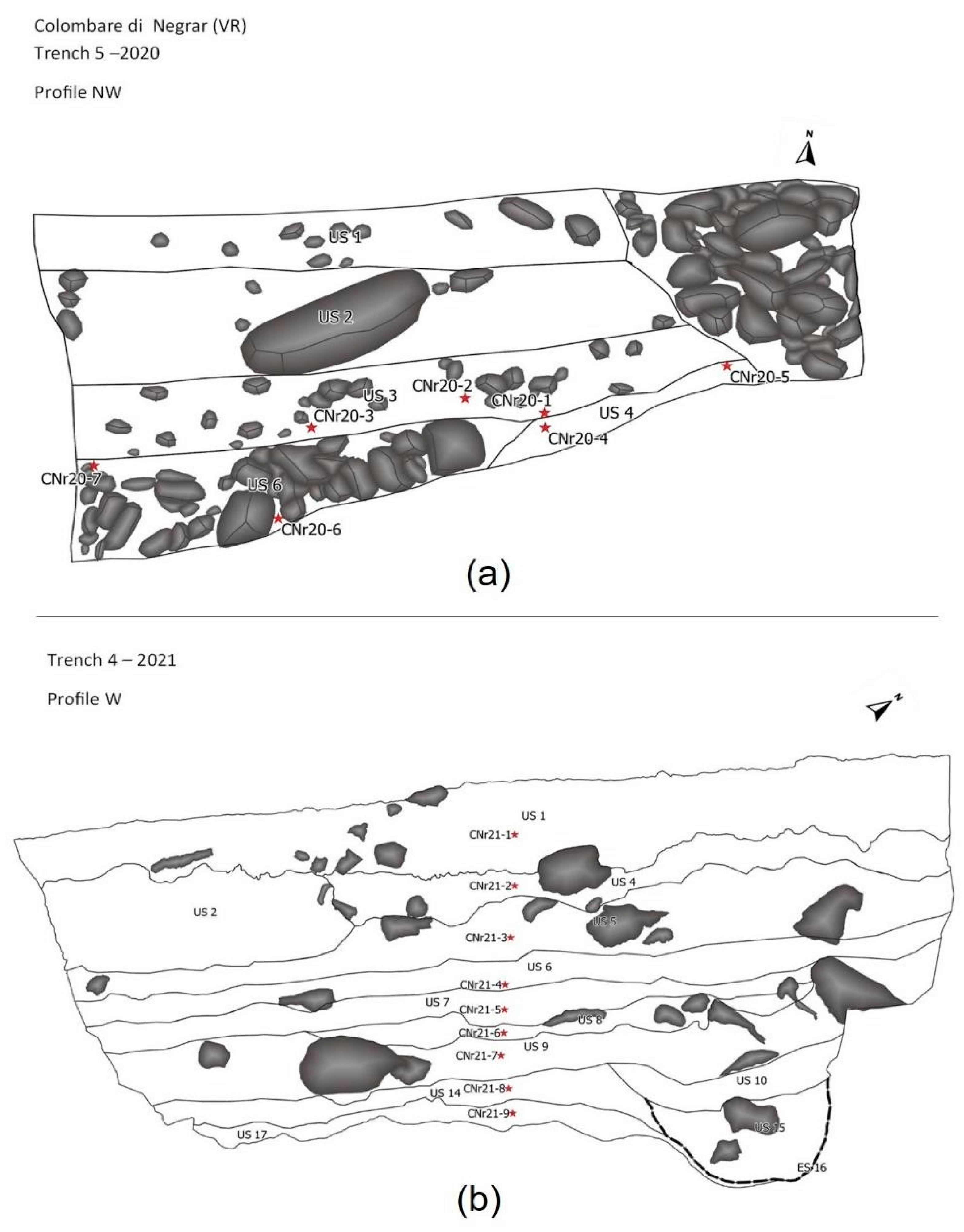
From Trench 5, excavated in 2020, seven samples (CNr20 1–7) were taken which belong to three stratigraphical units, not describing a sequence (Figure 2a). From the Trench 4 excavated in 2021, nine samples (CNr21 1–9) were taken in a vertical sequence through nine stratigraphical units (Figure 2b). The order given by the years of sampling was adopted to present the results.
A moss polster growing near the Trench 4 has been also collected to obtain the modern pollen rain (Table 1).
About 2–4 g of sediment was subjected to pollen extraction according to the method in use at the Laboratory of Palynology and Palaeobotany of Modena, which provides enough pollen even when the pollen concentration is low [14,15]. The pollen extraction method includes sieving and heavy liquid separation (Na-metatungstate hydrate) to allow pollen concentration. Pollen extraction from moss polster required 10% NaOH. Lycopodium spores were added to calculate concentrations, which were expressed as pollen per gram (= p/g). Pollen was identified at 600x and 1000x magnification on permanent slides, with the help of atlases/keys [16,17] and the reference pollen collection of Modena. The identification of cereal pollen was mainly based on the criteria by Andersen [18] and Beug [19], with the correction factor for glycerol jelly [8]. About 300 pollen grains per sample were counted. Pollen percentages were calculated on a pollen sum including all pollen grains. Fern spores and reworked pollen percentages are calculated in a new sum including pollen sum + themselves.
To assess forest cover, the ratio of the percentages of Arboreal pollen (AP–including trees, shrubs, and lianas) to Non-Arboreal pollen (NAP) was calculated. Sums of the selected pollen taxa useful for environmental and land-use reconstructions were calculated: (i) mixed oak wood (deciduous Quercus, Corylus, Carpinus betulus, Ostrya carpinifolia/Carpinus orientalis, Acer, Fraxinus spp., Tilia, Ulmus); (ii) wet environments (hygrophilous trees, hygrophilous herbs, hydrophytes), (iii) anthropogenic pollen (OJC group, wild synanthropic plants, cereals; [11,20]. The botanical nomenclature follows APG IV (The Angiosperm Phylogeny Group, 2016) and The Plant List Version 1.1 (2013). Pollen diagrams were drawn with Tilia [21]. Cluster analysis was applied to Trench 4, and two pollen zones based on CONISS have been identified. Pollen data from both trenches 4 and 5 were ordinated by Principal Component Analysis (PCA) using XLSTAT software. The PCA analysis was performed using pollen taxa as variables.

2.3.2. Seeds and Fruits

From Trench 5, three samples of sediment were analysed from three stratigraphical units (Table 2). A total volume of 40l was processed by wet-sieving with 0.5 mm and 1 mm mesh sieves. Identification of seeds and fruits was carried out using a stereomicroscope (×6.5 to ×40 magnifications) and by employing the Musei Civici di Como reference collection and reference works [22,23,24,25,26,27,28]. The botanical nomenclature of wild plants was reported according to Flora d’Italia [29]; the nomenclature of cultivars follows Zohary et al. [30].

3. Results

3.1. Palynology

A total of ~5230 pollen grains were counted in the 16 archaeological samples (~310 pollen/sample), while another 300 grains were counted in the moss cushion. The moss cushion shows the current pollen rain that includes only three pollen taxa not found in the archaeological samples: Ilex aquifolium, Quercus ilex type, and Artemisia; moreover, Celtis, Juniperus type, and Nerium oleander were found only in Trench 5. The AP/NAP-Arboreal/Non-Arboreal Pollen ratio (48/52) shows a forest cover higher than the past (21/79 on average), prevalently composed by deciduous Quercus and Ostrya carpinifolia/Carpinus orientalis type.
In the archaeological samples, the state of preservation is generally poor, with folded and crumpled pollen grains, but reliable identification was possible (Figure 3). Some secondary (reworked) pollen, which were included in the layer but not coeval, were found. They may be pollen that arrived in the deposit with river sediments (which themselves contain pollen from other places); in this context they may have arrived by unvoluntary human transport or from the runoff of the sloping terraced soil. The pollen concentration is high, from ~62,600 p/g of Trench 5 to ~115,000 p/g of Trench 4.
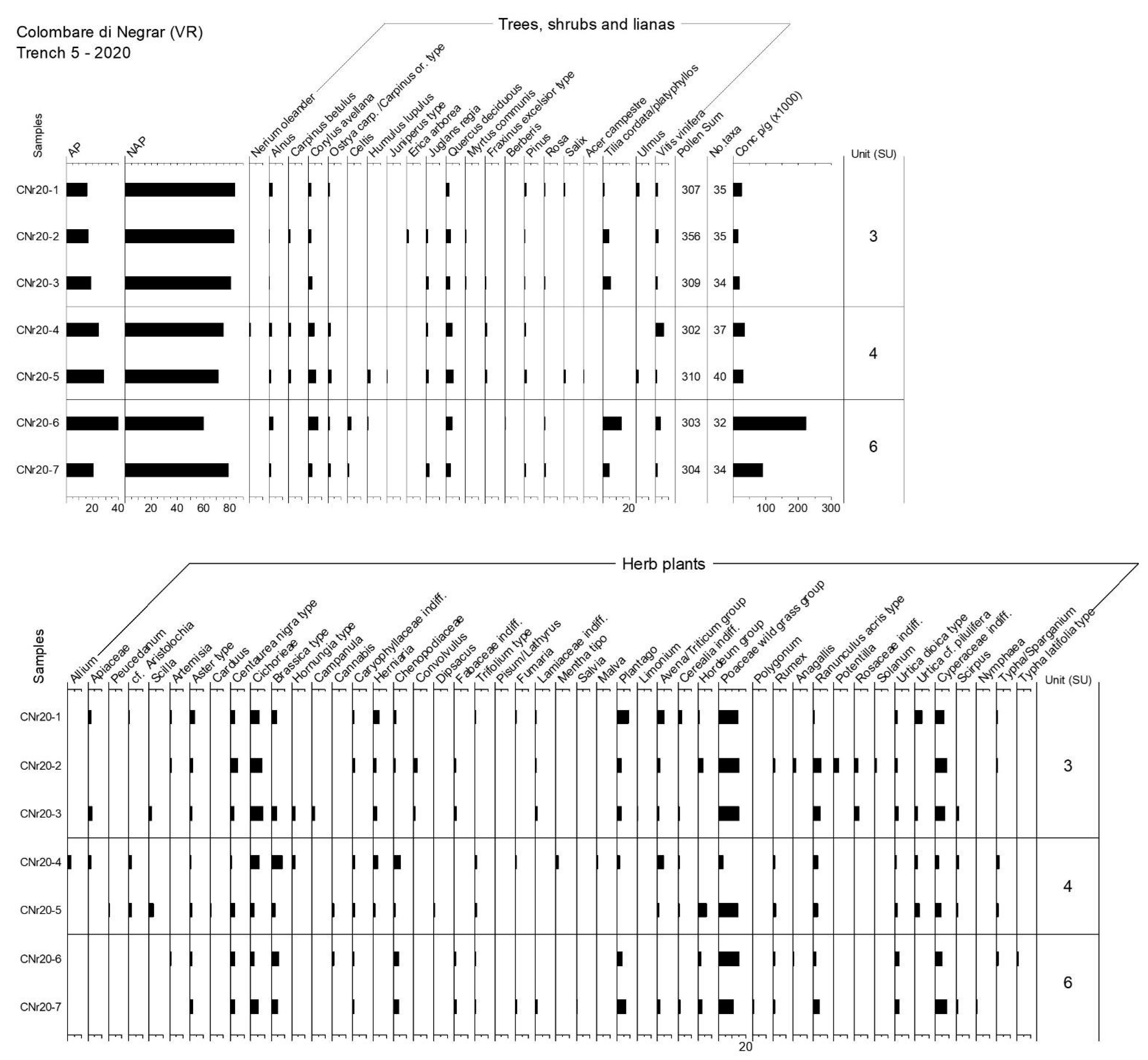
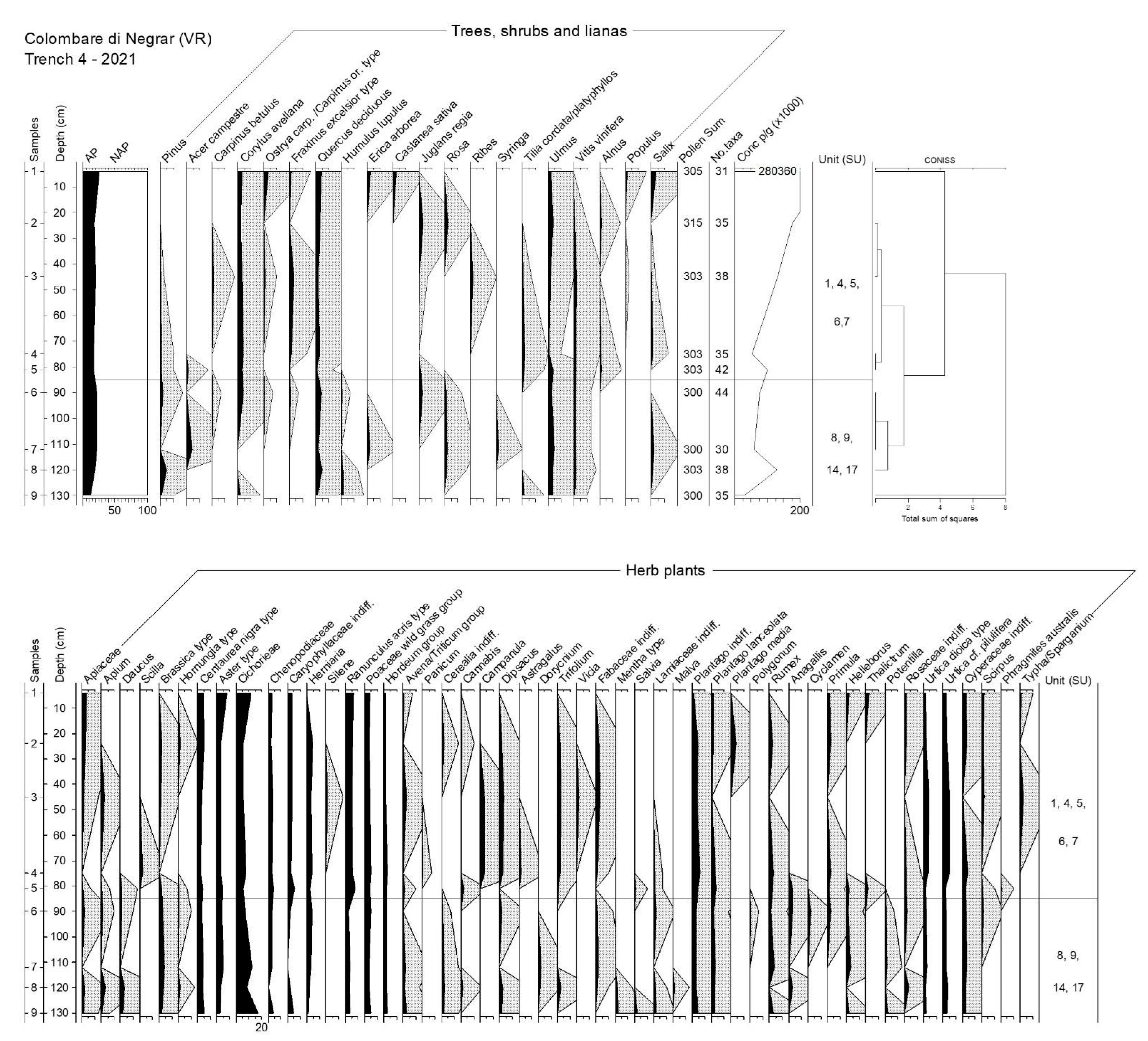
The floristic richness of pollen spectra suggests that the environment in which sediments were deposited was characterised by a quite good biodiversity. The length of the floristic list is quite similar in both trenches (68 taxa in Trench 5, and 75 taxa in Trench 4) but quite variable, from 30 to 44, in each sample. The list of woody taxa (trees, shrubs, and lianas) includes 20 taxa in Trench 5 and 25 taxa in Trench 4. Pollen spectra from the archaeological samples are shown in pollen diagrams (Figure 4 and Figure 5).
Additionally, the AP/NAP ratio is quite comparable in the two trenches (23/77 in Trench 5, and 19/81 in Trench 4) and indicates low forest cover. The presence of trees is marked by deciduous Quercus which has 3–4% on average, and reaches the highest percentage ~5%, in the bottom of Trench 5 (Unit 4–2020), and of Trench 4. Corylus avellana is ubiquitous in Trench 5, with 4% on average, and has similar values in the upper half of the sequence. Ulmus is ubiquitous in Trench 4, with 3% on average, but is sporadic in Trench 5 (<1%).
Tilia cordata/platyphyllos is less common but quite frequent, and interestingly shows ~2% in some samples of Trench 4 (CNr21-4), and ~5% in Trench 5; the very remarkable value of 14% in sample CNr20-6 indicates a local presence of lime flowers (possibly a transport of branches and leaves into the site). The pollen of Tilia is of special interest because it presents an intermediate morphology between Tilia cordata type and Tilia platyphyllos type [31]. The main traits of the two types are as follows:
T. cordata type = pollen grains with an equatorial diameter of 33–40 μm, 3 colpora, and a fine reticulum with 8–11 tectal concavities × 10 μm at the coarsest pole.
T. platyphyllos type = pollen grains with an equatorial diameter of 38–48 μm, 3/4 colpora, and a medium reticulum with 4–6 tectal concavities × 10 μm at the coarsest pole.
In sample CNr20–6, a total of 33 pollen of Tilia were observed. Six of them were very crumpled and not identifiable; among the others, there were some intermediate cases:
-
A total of three grains has large reticulum and diameter 43–47 μm, as T. platyphyllos type;
-
A total of nine grains has four apertures and a diameter < 40 μm;
-
A total of 24 grains has a fine reticulum: 5 are 35–36 μm as T. cordata type, and 19 are 43–47 μm. Therefore, pollen morphology suggests that the lime trees belonged to two species that hybridize between them.
Other significant pollen are Alnus and Salix attesting hygrophilous woods, and Ostrya carpinifolia/Carpinus orientalis type, Juglans and Pinus, with ~1% on average each. Of interest is Vitis, recorded in all samples (absent only in CNr21-1), with 2.7% and 1.4% on average in Trench 5 and Trench 4, respectively. Together with the above- mentioned hazelnut and walnut trees, and with Ribes and Rosa, grapevine represents important plants supplying fruits to people. Among NAP, three families are ubiquitous: Poaceae wild grass-group has the highest percentage (12.5% in Trench 5, and 4% in Trench 4, on average), followed by Cyperaceae (7–4%) and Cichorieae (6–9%). Additionally, Plantago and Asteroideae have values > 4%; Brassicaceae, represented by Brassica type and Hornungia type, are ~3–5% on average, the same percentages reached by Ranunculus acris type in both the trenches. Cereals are represented by Avena/Triticum group, Cerealia undiff., and Hordeum group (4% in Trench 4, and 5.4% in Trench 5). Traces of Panicum were found only in Trench 4. Other possibly used plants are represented by pollen of Cannabis, Mentha type, and Rumex.
Despite a general similarity of pollen spectra throughout the diagram, the pollen diagram of Trench 4 can be divided in two zones (Figure 5):
-
The bottom zone (samples no. 9 to 6; SU 17,14,9,8) is characterised by the presence of Pinus, Acer, Humulus lupulus, and Syringa among the woody plants, while Daucus, Potentilla, Anagallis, Cyclamen, and Lamiaceae are more evident than in the other zone;
-
The top zone (samples no. 5 to 1; SU 7,6,5,4,1) shows the main changes in the increase in values of Ostrya carpinifolia/Carpinus orientalis type, Fraxinus excelsior type, and Tilia cordata/platyphyllos; the latter marks a significant rise in wet conditions as confirmed by the appearance of Alnus and Populus trees, besides Typha/Sparganium among the herbaceous plants. Accordingly, the Cichorieae tribe has a slight decrease.
The PCA (Figure 6) shows a clear environmental and climatic connotation along with evidence of a mixed economy. The first PC explains 16.08% (F1) of the total variance, the second PC explains 14.08% (F2). The first PC has low loadings for many herbaceous pollen taxa in a context characterized by light-demanding species typical of grasslands and pastures together with xerophilous shrubs and plants with a synanthropic value (e.g., Centaurea nigra type, Cichorieae and other Asteraceae, and Erica arborea), while high loadings correspond to many arboreal pollen taxa which may be associated with the presence of mixed oak wood and riparian vegetation (e.g., deciduous Quercus, Corylus avellana, and Vitis vinifera). In accordance with the arrangement of the variables on the PCA plane, the first component separates pollen spectra along a forestation gradient from an “open landscape” to a “forested environment”. The second component has high loadings for pollen taxa related to wet (e.g., Cyperaceae, Typha latifolia type, and Poaceae wild grass group) and cool (e.g., Tilia cordata/platyphyllos) climatic conditions, while prevalently pollen taxa typical of arid or semi-arid environments have low loadings (e.g., Caryophyllaceae, Apiaceae, and Plantago lanceolata). The second component separates pollen spectra along a climatic gradient from a drier to a wetter and cool environment. Samples of Trench 5 and Trench 4 separate perfectly along the second component. Overall, the arrangement of samples in the PCA space seems to reflect the presence of a mixed economy with crop fields and pastures. In particular, anthropogenic pollen indicators are mainly concentrated in quadrants III and IV, suggesting the coexistence of different land uses in the study area.

3.2. Seeds and Fruits

The identified macroremains are 313, of which 63 were not clearly identified (undetermined seeds/fruits). Most of the remains are charred, and only two from SU 2 are mineralized (one seed of cf. Solanum nigrum, and one Rosaceae). The concentration is quite low: 7.9 remains/l in SU 3 and 6.7 remains/l in SU 6. The higher concentration of remains is in SU 2 (10.9 remains/l), but this layer was not radiocarbon dated. In the analysed samples, cereals (166 remains), fruits (70 remains), and weed seeds were ubiquitous, whereas only two pulses (one seed of Pisum sativum in SU 2, and one of Vicia/Lathyrus in SU 3) were found. Cereals are the main crop in the site, although most of the remains are heavily fragmented or deformed. Among the few identified grains, there are Hordeum vulgare (five grains) and Hordeum/Triticum (five grains). The presence of other crops is indicated by chaff remains: most of them were identified at the genus level (Triticum sp.) or with a degree of uncertainty (T. dicoccum/timopheevii, T. monococcum/timopheevii, T. cf. dicoccum, T. cf. monococcum, T. cf. timopheevii); among the identified chaff, Triticum dicoccum is the most abundant followed by T. timopheevii and T. monococcum. The number of remains and cereal diversity are different in SU 3 and SU 6.
In SU 6, we have only chaff remains of emmer and “new” glume wheat, which seems to be quite important in this site (31% of whole cereals); the presence of einkorn appears less significant, and barley is absent. In SU 3, emmer chaff remains are always the most numerous, whereas “new” glume wheat decreases (3% of whole cereals). Furthermore, in this layer, two barley and three Hordeum/Triticum grains are present.
The remains of gathered fruits are not abundant. Hazelnut (Corylus avellana) is one of the main gathered plants together with wild grape (Vitis vinifera subsp. sylvestris). Acorns (Quercus sp.) are present only in SU 2. Few remains of other woody plants with edible fruits are represented by Cornus mas, C. sanguinea, and Sambucus nigra. Weeds of fields or gardens and ruderals have been identified and include Sambucus ebulus, Fallopia convolvulus, Polygonum sp., Ranunculus sp., and Solanum nigrum.

4. Discussion

The pollen spectra from Colombare are quite similar between each other throughout the different phases of occupation. They are characterised by some plant associations: oak wood, hygrophilous wood, wet environments, and many synanthropic plants.
The comparison with the present pollen rain in the site suggests that forest cover of the past (AP average = 22%) was less closed/continuous than today (AP = 48%). In the moss polster, oaks and hop-hornbeam (Ostrya carpinifolia) pollen represent the main elements of the current forest vegetation. Pollen shows that through the chronological frame investigated (4300–3500 cal BC), the landscape was open and influenced by human activities. The availability of natural clearings in the wood probably favoured the establishment of the site. A mixed oak wood with deciduous Quercus, Acer campestre, Fraxinus excelsior type, Carpinus betulus, and Ostrya carpinifolia/Carpinus orientalis type is the main component of the forest cover. Similarly, a mixed oak wood in the surroundings of an open area was also put in evidence by the on-site pollen reconstruction of the prehistoric site of Gardolo, in Trentino, during the Bronze Age [32]. Shrubs belonging to Mediterranean species were also distributed in the sunny slopes: Erica arborea and Myrtus communis.

4.1. Tilia Species and Hybrids in the Wood

In Colombare, the oak wood was probably cool and wet (testified by the abundance of lime-Tilia and elm-Ulmus), and particularly rich in lime trees at ~3700 cal BC (SU 6, and SU 3). Elm, ubiquitous in Trench 4 and present in Trench 5, was likely spread in wet environments that were also suitable for the growth of grapevines. High percentage values of Tilia, comparable to those found here, have been observed in the pollen spectra of sites of the Po Valley dated to the Atlantic and the Subboreal (between ~6200 and ~2200 cal BC; [33], and in the Neolithic site of Lugo di Romagna (FG-LUGO near-site sequence; [34]). In Europe, Tilia was an important component of primary forests, and its abundance with Ulmus characterised many European forests between ~7000 and ~4000 cal BC [35]; then, a decline of elm was followed by that of lime in the last 5000 years [36]. A recent synthesis on past distribution patterns of Tilia in Europe documents that the generalist species T. cordata has been the most successful lime species under the Holocene climate trajectories over most Europe, whereas T. platyphyllos evolved relict subspecies in mountain ranges under the pressure of unfavourable climate conditions [37]. Both natural and anthropogenic causes have led to the decline of lime, such as paludification, inundation, stratigraphic disturbances, and the inability of restoring trees once destroyed [36].
The recovery of the intermediate morphology between Tilia cordata type and Tilia platyphyllos type suggests the presence of lime hybrids within the oak wood. In recent studies, pollen size and shape have been recognised as important features to diagnosing Quercus parental species and hybrids [38]. In the pollen of Tilia × vulgaris Hayne, which is considered a natural hybrid between T. platyphyllos and T. cordata, the exine patterns typical of each pollen type are mixed, and pollen morphology of the hybrids is diagnostic of the phenotypic expression of the mixed genotypes [39]. In the studied site, the intermediate morphology of pollen size and exine may be regarded as the first palynological evidence of lime hybrids in palaeorecords.
Lime pollen is not commonly abundant in sediments, as it is an entomophilous specie and does not spread high quantities of pollen in the air [16]. Therefore, its presence is a clear index of local growing of the plants, suggesting the presence of a mixed oak wood with high presence of lime close to the site. Currently, in Italy, T. platyphyllos Scop. lives in mesophilous mountain forests; in the lowlands it is confined to areas with neutral, humus-rich, moist but well-drained soils [40]. In Veneto, lime trees are frequent in different types of woods: T. cordata Mill. constitutes the Ornithogalum pyrenaici-Carpinetum betuli (‘aceri-tiglieto tipico’), and the mesophilous Carici umbrosae-Quercetum petraeae (‘rovereto con tiglio’ association). The latter may be recognised, for example, in CNr21-5, with Quercus and Acer, while the highest presence of Tilia (14.2%), found in CNr20-6, is linked to a high presence of Corylus (8%) and Vitis (4.5%). Interestingly, lime has been cultivated for leaf-forage and used with elm to grow grapevine with the ‘vite maritata’ technique until recent times [41].

4.2. Hazelnut, Grapevine, and the Other Traits of the Landscape

Hazelnut is an important food plant, and has a wood appreciated for its durability and elasticity, also used for basketry. The significant presence of hazelnut in all the spectra of Trench 5 suggests that probably it was among the trees living in the sub-montane wood phytocoenon Galanthus-Corylus (‘corileto’), a plant association that recolonises grazed or mowed areas and spread within disturbed tree stands [42]. These woods are therefore formations that may have had an anthropic origin rooted in the Neolithic of the region.
The oak wood supplied timber and offered many wild fruits. Not only the above- mentioned hazelnuts and grapevine, but also walnut-Juglans regia, Rosa, and Ribes were found, and chestnut-Castanea sativa was late in Trench 4. Hazelnut shells together with seeds of the wild grape are also attested in the macroremain record. Corylus and Vitis were found as seeds/fruits and wood, and chestnut as wood, from the Middle/Recent Bronze Age record of the Terramara di Montale, while Juglans was common in the pollen sequence [43].

4.3. Wet Environments

The hygrophilous wood, with Alnus, Salix, and Populus, together with hygrophilous herbs, such as Cyperaceae and Typha, were also present, suggesting that the site was located near a watercourse or close to springs. Wet environments likely also hosted elm trees and wild grapevine lianas. Vitis vinifera is, in fact, strictly dependent on riparian woodland and wet soil conditions. Vitis pollen is generally considered an underrepresented pollen, even in past contexts [44,45]. In this site, Vitis pollen is so frequent, also occurring in high percentages (max 6.3% in CNr20-4, SU 4), that it is plausible to assume some special care of this plant, probably for its edible fruit. Plants were transported on-site or grew next to the site. We argue that this may be evidence of a complex relationship of people with these food plants: not only the harvesting of wild fruits as a food supplement, but also an initial practice of caring for the woody plants that grew in the mixed oak forest surrounding the site, even prior to cultivation. The records from Colombare highlight the importance of such economic exploitation during the Neolithic and Bronze Age in northern Italy. The key role in the prehistory of grapevine has been already well attested for the Middle Bronze Age in the Po Valley (~1600–1200 cal BC; terramaras of Poviglio, Montale, Baggiovara in Emilia Romagna: [43,46,47], and in other regions such as Sardinia (~1300–1100 cal BC; [48]). The tartaric acid residues found together with pips in the Bronze Age pottery recovered from the two sites Pilastri di Bondeno (Ferrara) and Canale Anfora (Aquileia, Udine), dated to the 15th and 14th centuries BC, testified to the early consumption of wine or other grape derivatives, such as vinegar or must, in north-eastern Italy [49].
In the spectra of Trench 5, noteworthy is the presence of Nerium oleander (only in the pre-site sample CNr20-4). Oleander has spread in the Mediterranean vegetation during the last post-glacial period, subsequently favoured by humans that used this species as an ornamental cultivated plant [50]. This Mediterranean evergreen shrub is attested in a relatively drier phase in Colombare, whose microclimate has always been influenced by the proximity to Lake Garda.

4.4. Cereals and Pasturelands

Significant amount of cereal pollen, common in the spectra, suggests that crop fields were present in the area. Barley is ubiquitous, but both the major cereal types reach the highest amount in Trench 5: barley has its maximum 5.8% in CNr20-5, while oat/wheat has its maximum 4.9% in CNr20-1. This evidence well-matches plant macroremains from the same trench: barley (Hordeum vulgare) and chaff residues from the threshing of wheats (Triticum monoccoccum and T. dicoccum, and a wheat like durum wheat T. timopheevii) were identified. The presence of chaff remains suggests that Triticum species have been processed on site. Naked wheat (T. aestivum/durum/turgidum) and spelt (T. spelta) were absent and instead were found in the Square Mouthed Pottery sites (Middle Neolithic, ~5000–4000/3800 cal BC; N Italy), even though they had few remains [51], whereas in the northern Alps, spelt seemed to be already present in the Bell Beaker [52], even if it was not part of the culture set [53]. Panicum is so poorly represented that no evidence of local cultivation can be inferred from the pollen diagram of Trench 4 (Figure 5). Nevertheless, millet is quite common in Italian Bronze Age sites (macroremains: [54,55,56]; pollen and miliacin: [57,58]; stable isotopes: [59]) and its cultivation in European contexts has been documented since the 16th century BC [60].
Finally, the presence of pasture meadows is suggested by significant and diversified pollen of Asteraceae (14.6% on average), with Aster type, Carduus, Centaurea nigra type, and Cichorieae [61]. The latter pollen was ubiquitous but not high in the spectra, confirming their role of bitter plants often avoided by herbivores and as excellent indicators of the continuous agro-pastoral activities practiced in the territory.

4.5. Environmental Conditions at the Establishment of the Site

Colombare di Negrar was settled in a place where the forest was rather sparse (SU 4 of Trench 5; Figure 4) and the onset of the site had an impact on the local vegetation. In fact, the pre-settlement (SU 6) and early settlement levels show the highest forest cover values of the record. In Trench 5, the bottom samples have the highest values of deciduous Quercus and Corylus avellana, but they decrease with the forest cover at the top (SU 3). Woodland was low at the time of occupation of the site. Synanthropic species characterise the spectra including Urtica, Centaurea nigra type, and Cichorieae, suggesting nitrogen-rich soils and the presence of pasturelands locally. Accordingly, Plantago supports the occurrence of on-site trampling as it occurs in the case of animal breeding. Archaeozoological data show the interesting presence of some domestic animals such as Bos taurus, Capra/Ovis (SU 6,3), Sus, and Ovis aries (SU 3) [1,3].

4.6. Environmental Transformations during the Site Occupation

The environmental changes that occurred during the occupation of the site can be inferred by the palynological sequence of Trench 4. Cluster analysis identified two main zones corresponding to a relatively dry and open environment at the bottom, and a cooler and wet phase, with a shrubbier plant cover at the half top of the diagram (Figure 5 and Figure 6).
At the bottom of the diagram, forest cover is very low and then remains substantially steady towards the top, while remaining far (below) from the value of the current pollen rain (Figure 5). In the oldest sample, the anemophilous trees (i.e., Pinus and Quercus) largely represent the sparse wood, with hop and rose (Humulus lupulus and Rosa) and some wet environments significantly marked by Ulmus, (wild) Vitis, and some Salix. The open landscape was covered with a large set of herbaceous plants, largely including numerous pastureland indicators such as Apiaceae, Brassica type, Cichorieae and other Asteraceae, Caryophyllaceae, Ranunculus acris type, Anagallis, Rumex, and Plantago. The presence of quite diversified cereals and Cannabis marks the agrarian economy at the site, with crops transported into the site from the fields. A mixed economy based on crop fields and the breeding of domestic animals is attested in this zone. These features continue to be quite constant along the profile, suggesting that no major interferences have affected the forest cover in the millennia of occupation documented in Trench 4 and 5. Some changes in wood floristic composition are visible in the top zone: there is the reduction in Pinus, Acer campestre, and Rosa, while Corylus avellana, Fraxinus excelsior type, Tilia, and Alnus clearly increase. Additionally, Juglans regia is more common and increases towards the top of the diagram, then is substituted by Castanea, which spreads with Ostrya carpinifolia/Carpinus orientalis type and Populus—the latter growing next to water places. Accordingly, cattails and sedges are more present in this zone, suggesting the enlargement of freshwater places. Pollen concentration increases in the second zone, showing that a greater amount of organic matter has been transported and accumulated in the deposit as result of human activities. Fabaceae increase and possibly reveal the presence of wet pasturelands.

5. Conclusions

Based on the new archaeobotanical and palynological data, a clear environmental profile emerges from the interdisciplinary research carried out in the site of Colombare di Negrar di Valpolicella in 2019–2021. First, pollen evidence shows that the site settled in a place with the availability of natural, non- flooded open spaces and where the forest was rather sparse.
Proximity to the forest ensured supply for leaf-forage, timber, and wild fruits. Hazelnut should have played a key role among food plants, together with walnut. Vitis vinifera was strictly dependent on riparian woodlands, and it is plausible that people paid special attention to this food plant. The combined approach of pollen and plant macroremains analysis has provided new information on local biodiversity and on the precise intertwining between the resources offered by the natural environment and the socio-economic and cultural evolution at the prehistoric site of Colombare di Negrar during the Late Neolithic and Early Bronze Age.
Archaeobotanical records from the site highlight the local presence of a mixed economy based on animal breeding, also confirmed by archaeozoological data, and crop fields including many cereals and hemp. As already observed in other sites in Europe within the Mediterranean basin from the Pre-Neolithic to the Recent Bronze Age [12], several subsistence strategies existed simultaneously at Colombare di Negrar, including forest management for fruit and leaf collection, pastures, and cereal cultivation. Human activities probably took place within a sylvo-pastoral and crop farming mixed systems to make the most of the natural resources offered by a hilly landscape characterised by a general ecological and phytogeographical diversity.
Interestingly, among the arboreal pollen, the presence of an intermediate pollen morphology between Tilia cordata type and Tilia platyphyllos type suggests the occurrence of hybrid lime trees in the forest cover; this may be considered the first palynological evidence of lime hybrids in palaeoenvironmental contexts.

Author Contributions

Conceptualization, U.T. and A.M.M.; methodology, U.T. and A.M.M.; formal analysis, E.R. and B.P.; data curation, A.F., E.C., C.R. and C.P.; writing—original draft preparation, U.T., F.G., B.P., A.M.M., E.R. and E.C.; writing—review and editing, A.M.M., A.F., U.T., F.G. and B.P.; visualisation: C.P., C.R. and P.S.; supervision, U.T. and P.S.; project administration, U.T. and P.S.; funding acquisition, U.T. All authors have read and agreed to the published version of the manuscript.

Funding

This research was funded by State University of Milan, Linea 2_2020_AZIONE_A.

Institutional Review Board Statement

Not applicable.

Informed Consent Statement

Not applicable.

Data Availability Statement

The data that support the findings of this study are available from the corresponding author upon request.

Acknowledgments

We sincerely thank the Administrative Office (head Dario Barbera) of the Department of Cultural and Environmental Heritage of the University of Milan (head Alberto Bentoglio), and also Paola Galimberti (head of Performance, Quality Assurance, Evaluation, and Open Science Policy Directorate.) and the staff of the university fund Article Processing Charges for their cooperation and sensitivity.

Conflicts of Interest

The authors declare no conflict of interest.

References

  1. Tecchiati, U.; Salzani, P.; Orioli, M.; Mercuri, A.M.; Talamo, S.; Nicosia, C.; Amato, A.; Casati, S.; Cercatillo, S.; Florenzano, A.; et al. Agricoltura e gestione del territorio nell’età del Rame dei Lessini occidentali: Lavori in corso nel sito di Colombare di Villa (Negrar di Valpolicella, VR). IpoTESI di Preistoria 2021, 14, 59–74. [Google Scholar] [CrossRef]
  2. Tecchiati, U.; Castiglioni, E.; Rottoli, M. Economia di sussistenza nell’età del Rame dell’Italia settentrionale. Il contributo di archeozoologia e archeobotanica. In L’età del Rame: La Pianura Padana e le Alpi al Tempo di Ötzi; de Marinis, R.C., Ed.; La Compagnia Della Stampa Massetti Rodella: Brescia, Italy, 2013; pp. 39–52. [Google Scholar]
  3. Riedel, A. La fauna del villaggio eneolitico delle Colombare di Negrar (Verona). Bollettino del Museo Civico di Storia Naturale di Verona 1976, 3, 205–238. [Google Scholar]
  4. Zorzi, F. Resti di un abitato capannicolo eneolitico alle Colombare di Negrar (Verona). In Actes du IV Congrès International du Quaternaire (Rome-Pise, août-septembre 1953); Blanc, G.A., Ed.; Istituto Italiano di Paleontologia Umana: Roma, Italy, 1956; pp. 3–15. [Google Scholar]
  5. Zorzi, F. Insediamenti e stirpi. Capitolo II: Le culture oloceniche in Preistoria Veronese. In Verona e il Suo Territorio; Cavallari, V., Gazzola, P., Scolari, A., Eds.; Istituto per gli Studi Storici Veronesi: Valdonega, Italy, 1960; Volume 1, pp. 98–114. [Google Scholar]
  6. Tecchiati, U.; Salzani, P.; Orioli, M.; Mercuri, A.M.; Talamo, S.; Amato, A.; Casati, S.; Florenzano, A.; Palmisano, E.; Proserpio, B.; et al. Indagini archeologiche e paleoambientali nel sito neolitico e dell’età del Rame delle Colombare di Villa (Comune di Negrar di Valpolicella, VR). In Abstract Book della Riunione Scientifica dell’Istituto Italiano di Preistoria e Protostoria (Ferrara, 20–23 ottobre 2021); Arzarello, M., Fontana, F., Peresani, M., Thun Hohenstein, U., Eds.; Istituto Italiano di Preistoria e Protostoria: Firenze, Italy, 2021; pp. 5–6. [Google Scholar]
  7. Pearsall, D.M. Palaeoethnobotany: A Handbook of Procedures, 2nd ed.; Academic Press: San Diego, CA, USA, 2000. [Google Scholar]
  8. Faegri, K.; Kaland, P.E.; Krzywinski, K. Textbook of Pollen Analysis, 4th ed.; John Wiley and Sons: Chichester, UK, 1989. [Google Scholar]
  9. Mercuri, A.M. Genesis and evolution of the cultural landscape in central Mediterranean: The ‘where, when and how’ through the palynological approach. Landsc. Ecol. 2014, 29, 1799–1810. [Google Scholar] [CrossRef]
  10. Behre, K.E. Anthropogenic Indicators in Pollen Diagrams; A.A.Balkema: Rotterdam, The Netherlands, 1986. [Google Scholar]
  11. Mercuri, A.M.; Bandini Mazzanti, M.; Florenzano, A.; Montecchi, M.C.; Rattighieri, E.; Torri, P. Anthropogenic Pollen Indicators (API) from archaeological sites as local evidence of human-induced environments in the Italian peninsula. Ann. Bot. 2013, 3, 143–153. [Google Scholar] [CrossRef]
  12. Mercuri, A.M.; Florenzano, A.; Burjachs, F.; Giardini, M.; Kouli, K.; Masi, A.; Picornell-Gelabert, L.; Revelles, J.; Sadori, L.; Servera-Vives, G.; et al. From influence to impact: The multifunctional land-use in Mediterranean prehistory emerging from palynology of archaeological sites (8.0–2.8 ka BP). Holocene 2019, 29, 830–846. [Google Scholar] [CrossRef] [Green Version]
  13. Tecchiati, U.; Putzolu, C. Un approccio globale al concetto di sistema territoriale: Alcune riflessioni di metodo. In Tiziano Mannoni: Attualità e Sviluppi di Metodi e Idee; ISCUM, Ed.; All’Insegna del Giglio: Firenze, Italy, 2021; Volume 2, pp. 521–523. [Google Scholar]
  14. Florenzano, A.; Mercuri, A.M.; Pederzoli, A.; Torri, P.; Bosi, G.; Olmi, L.; Rinaldi, R.; Bandini Mazzanti, M. The significance of intestinal parasite remains in pollen samples from Mediaeval pits in the Piazza Garibaldi of Parma, Emilia-Romagna, Northern Italy. Geoarchaeology 2012, 27, 34–47. [Google Scholar] [CrossRef]
  15. van der Kaars, S.; Penny, D.; Tibby, J.; Fluin, J.; Dam, R.; Suparan, P. Late Quaternary palaeoecology, palynology and palaeolimnology of a tropical lowland swamp: Rawa Danau, West Java, Indonesia. Palaeogeogr. Palaeoclimatol. Palaeoecol. 2001, 171, 185–212. [Google Scholar] [CrossRef]
  16. Moore, P.D.; Webb, J.A.; Collins, M.E. Pollen Analysis, 2nd ed.; Blackwell Sc. Publ.: Oxford, UK, 1991. [Google Scholar]
  17. Reille, M. Pollen et Spores d’Europe et d’Afrique du Nord; Laboratoire de Botanique Historique et Palinologie: Marseille, France, 1992. [Google Scholar]
  18. Andersen, S.T. Identification of Wild Grass and Cereal Pollen; Danmarks Geologiske Undersøgelse Aarbog: Copenaghen, Denmark, 1979. [Google Scholar]
  19. Beug, H.-J. Leitfaden der Pollenbestimmung für Mitteleuropa und Angrenzende Gebiete, 2nd ed.; Verlag Dr. Friedrich Pfeil: München, Germany, 2015. [Google Scholar]
  20. Mercuri, A.M.; Bandini Mazzanti, M.; Florenzano, A.; Montecchi, M.C.; Rattighieri, E. Olea, Juglans and Castanea: The OJC group as pollen evidence of the development of human-induced environments in the Italian peninsula. Quat. Int. 2013, 303, 24–42. [Google Scholar] [CrossRef]
  21. Grimm, E.C. Tilia and TGView; Illinois State Museum: Springfield, IL, USA, 2004. [Google Scholar]
  22. Berggren, G. Atlas of Seeds and Small Fruits of Nortwest-European Plant Species (Sweden, Norway, Denmark, East Fennoscandia and Iceland) with Morphological Descriptions: Part 2—Cyperaceae; Swedish Museum of Natural History: Stockholm, Sweden, 1969. [Google Scholar]
  23. Berggren, G. Atlas of Seeds and Small Fruits of Nortwest-European Plant Species (Sweden, Norway, Denmark, East Fennoscandia and Iceland) with Morphological Descriptions: Part 3—Salicaceae and Cruciferae; Swedish Museum of Natural History: Stockholm, Sweden, 1981. [Google Scholar]
  24. Jacomet, S. Identification of Cereal Remains from Archaeological Sites, 2nd ed.; Basel University: Basel, Switzerland, 2006. [Google Scholar]
  25. Jaquat, C. Les plantes de l’âge du Bronze. Catalogue des friuts et graines. Archeologie Neucheteloise. Bulletin Mensuel de la Société Linnéenne de Lyon 1989, 58, 5. [Google Scholar]
  26. Knörzer, K.H.; Kalis, A.J.; Meurers-Balke, J.; Tegtmeier, U. Geschichte Der Synanthropen Flora Im Niederrheingebiet: Pflanzenfunde Aus Archäologischen Ausgrabungen; Zabern: Mainz, Germany, 2007. [Google Scholar]
  27. Schoch, W.H.; Pawlik, B.; Schweingruber, F.H. Botanische Makroreste: Ein Atlas Zur Bestimmung Häufig Gefundener und Ökologisch Wichtiger Pflanzensamenn; Paul Haupt: Bern-Stuttgart, Switzerland, 1988. [Google Scholar]
  28. Cappers, R.; Neef, R.; Bekker, R. Digital Atlas of Economic Plants in Archaeology; Barkhuis & Groningen University Library: Groeniungen, The Netherlands, 2012. [Google Scholar]
  29. Pignatti, S. Flora d’Italia; Edizioni Edagricole: Bologna, Italy, 1982. [Google Scholar]
  30. Zohary, D.; Hopf, M.; Weiss, E. Domestication of Plants in the Old World: The Origin and Spread of Domesticated Plants in Southwest Asia, Europe, and the Mediterranean Basin, 4th ed.; Oxford University Press: Oxford, UK, 2012. [Google Scholar]
  31. Christensen, P.B.; Blackmore, S. Tiliaceae. In The Northwest European Pollen Flora V, Review of Palaeobotany and Palynology, 57; Punt, W., Blackmore, S., Clarke, G.C.S., Eds.; Elsevier: Amsterdam, The Netherlands, 1988; pp. 33–43. [Google Scholar]
  32. Zappa, J.; Torri, P.; Clò, E.; Rottoli, M.; Castiglioni, E.; Bassetti, M.; Mottes, E.; Mercuri, A.M. Vegetation changes and land-use history in the ritual site of Gardolo, Copper and Bronze Age site in Trentino (N Italy). Quaternary 2022. to be submitted. [Google Scholar]
  33. Accorsi, C.A.; Bandini Mazzanti, M.; Mercuri, A.M.; Rivalenti, C.; Trevisan Grandi, G. Holocene Forest pollen vegetation of the Po plain—Northern Italy (Emilia Romagna data). Allionia 1996, 34, 233–276. [Google Scholar]
  34. Torri, P.; Fornaciari, R.; Mercuri, A.M. Inferenze paleoambientali ed etnobotaniche dalla serie pollinica ‘FG-LUGO near-site’. In Il Villaggio Neolitico di Lugo di Romagna-Fornace Gattelli: Strutture Ambiente Culture; Steffè, G., Degasperi, N., Eds.; Istituto Italiano di Preistoria e Protostoria: Firenze, Italy, 2019; pp. 179–188. [Google Scholar]
  35. Giesecke, T.; Brewer, S.; Fisinger, W.; Leydet, M.; Bradshaw, R.H.W. Patterns and dynamics of European vegetation change over the last 15000 years. J. Biogeogr. 2017, 44, 1441–1456. [Google Scholar] [CrossRef] [Green Version]
  36. Grant, M.J.; Waller, M.P.; Groves, J.A. The Tilia decline: Vegetation change in lowland Britain during the mid and late Holocene. Quat. Sci. Rev. 2011, 30, 394–408. [Google Scholar] [CrossRef]
  37. De Benedetti, C.; Gerasimenko, N.; Ravazzi, C.; Magri, D. History of Tilia in Europe since the Eemian: Past distribution patterns. Rev. Palaeobot. Palynol. 2022, 307, 104778. [Google Scholar] [CrossRef]
  38. Wrońska-Pilarek, D.; Danielewicz, W.; Bocianowski, J.; Maliński, T.; Janyszek, M. Comparative pollen morphological analysis and its systematic implications on three European Oak (Quercus L., Fagaceae) species and their spontaneous hybrids. PLoS ONE 2016, 11, e016176. [Google Scholar] [CrossRef] [PubMed] [Green Version]
  39. Andrew, R. Exine pattern in the pollen of British species of Tilia. New Phytol. 1971, 70, 683–686. [Google Scholar] [CrossRef]
  40. Bernetti, G. Le Piante del Bosco. Forme, vita e Gestione; Compagnia delle Foreste: Arezzo, Italy, 2015. [Google Scholar]
  41. Associazione Culturale Borgo Baver Onlus. Dossier di Candidatura di una Pratica Tradizionale: La Piantata Veneta; Associazione Culturale Borgo Baver onlus: Godega di Sant’Urbano, Italy, 2017. [Google Scholar]
  42. Del Favero, R.; Carraro, G.; Dissegna, M.; Giaggio, C.; Savio, D.; Zen, S.; Abramo, E.; Andrich, O.; Corona, P.; Cassol, M.; et al. Biodiversità e Indicatori nei Tipi Forestali del Veneto; Regione del Veneto-Direzione Regionale Delle Foreste e Dell’Economia Montana, Accademia Italiana di Scienze Forestali: Mestre-Venezia, Italy, 2000. [Google Scholar]
  43. Mercuri, A.M.; Accorsi, C.A.; Bandini Mazzanti, M.; Bosi, G.; Cardarelli, A.; Labate, D.; Marchesini, M.; Trevisan Grandi, G. Economy and environment of Bronze Age settlements—Terramare—In the Po Plain (Northern Italy): First results of the archaeobotanical research at the Terramara di Montale. Veg. Hist. Archaeobotany 2006, 16, 43–60. [Google Scholar] [CrossRef]
  44. Turner, S.D.; Brown, A.G. Vitis pollen dispersal in and from organic vineyards I. Pollen trap and soil pollen data. Rev. Palaeobot. Palynol. 2004, 129, 117–132. [Google Scholar] [CrossRef]
  45. Mercuri, A.M.; Torri, P.; Florenzano, A.; Clò, E.; Mariotti Lippi, M.; Sgarbi, E.; Bignami, C. Sharing the agrarian knowledge with archaeology: First evidence of the dimorphism of Vitis pollen from the Middle Bronze Age of N Italy (Terramara Santa Rosa di Poviglio). Sustainability 2021, 13, 2287. [Google Scholar] [CrossRef]
  46. Cremaschi, M.; Mercuri, A.M.; Torri, P.; Florenzano, A.; Pizzi, C.; Marchesini, M.; Zerboni, A. Climate change versus land management in the Po Plain (Northern Italy) during the Bronze Age: New insights from the VP/VG sequence of the Terramara Santa Rosa di Poviglio. Quat. Sci. Rev. 2016, 136, 153–172. [Google Scholar] [CrossRef]
  47. Mercuri, A.M.; Montecchi, M.C.; Pellacani, G.; Florenzano, A.; Rattighieri, E.; Cardarelli, A. Environment, human impact and the role of trees on the Po plain during the Middle and Recent Bronze Age: Pollen evidence from the local influence of the terramare of Baggiovara and Casinalbo. Rev. Palaeobot. Palynol. 2015, 218, 231–249. [Google Scholar] [CrossRef]
  48. Ucchesu, M.; Orrù, M.; Grillo, O.; Venora, G.; Usai, A.; Serreli, P.F.; Bacchetta, G. Earliest evidence of a primitive cultivar of Vitis vinifera L. during the Bronze Age in Sardinia (Italy). Veget. Hist. Archaeobotany 2015, 24, 587–600. [Google Scholar] [CrossRef]
  49. Pecci, A.; Borgna, E.; Mileto, S.; Dalla Longa, E.; Bosi, G.; Florenzano, A.; Mercuri, A.M.; Corazza, S.; Marchesini, M.; Vidale, M. Wine consumption in Bronze Age Italy: Combining organic residue analysis. J. Archaeol. Sci. 2020, 123, 105256. [Google Scholar] [CrossRef]
  50. Lazzaro, L.; Sarracco, E.; Benesperi, R.; Coppi, A. A probable anthropic origin of Nerium oleander L. (Apocynaceae) population in Montecristo island (Italy, Tuscany): Evidence from loci polymorphism and ISSR analysis. Caryologia 2018, 71, 50–57. [Google Scholar] [CrossRef]
  51. Castiglioni, E.; Rottoli, M. I resti botanici da Maserà—Via Bolzani, Monselice—Via Valli e Este—Località Meggiaro nel quadro del Neolitico medio-recente e dell’Eneolitico in Italia settentrionale. In Dinamiche Insediative nel Territorio dei Colli Euganei dal Paleolitico al Medioevo, Atti del Convegno di Studi di Archeologia e Territorio, Este-Monselice, Italy, 27–28 November 2009; Bianchin Citton, E., Rossi, S., Zavonello, P., Eds.; Beni Culturali: Firenze, Italy, 2014; pp. 86–92. [Google Scholar]
  52. Akeret, O. Plant remains from Bell Beker site in Switzerland and the beginnings of Triticum spelta (spelt) cultivation in Europe. Veg. Hist. Archaeobotany 2005, 14, 279–286. [Google Scholar] [CrossRef]
  53. Lechterbeck, J.; Kerig, T.; Kleinmann, A.; Sillimann, M.; Wick, L.; Rösch, M. How was Bell Beker economy related to Corded Ware and Early Bronze Age lifestyles? Archaeological, botanical and palynological evidence from the Hegau, Western Lake Constance region. Environ. Archaeol. 2013, 19, 95–113. [Google Scholar] [CrossRef]
  54. Perego, R. Contribution to the Development of the Bronze Age Plant Economy in the Surrounding of the Alps: An Archaeobotanical Case Study of Two Early and Middle Bronze Age Sites in Northern Italy (Lake Garda region). Ph.D. Thesis, University of Basel, Basel, Switzerland, 2015. [Google Scholar]
  55. Berto, F.; Rottoli, M. Agricoltura e raccolta in un insediamento del Bronzo recente della pianura veronese: Il pozzetto US 317 di Fondo Paviani (Verona)—Scavi Università di Padova 2007–2012. In Preistoria e Protostoria del Veneto—(Studi di preistoria e Protostoria; Leonardi, G., Tiné, V., Eds.; Istituto Italiano di Preistoria e Protostoria: Firenze, Italy, 2015; pp. 829–832. [Google Scholar]
  56. Rottoli, M.; Castiglioni, E. Indagini sui resti vegetali macroscopici. In Acqua e Civiltà Nelle Terramare. La Vasca Votiva di Noceto; Bernabò Brea, M., Cremaschi, M., Eds.; Skira: Milano, Italy, 2009; pp. 152–163. [Google Scholar]
  57. Dal Corso, M.; Zanon, M.; Heron, C.; Rottoli, M.; Cupitò, M.; Dalla Longa, E.; Kirleis, W. Tracing millet through biomarker analyses in archaeological sites in alluvial plains: The first miliacin data from the northern Italian Bronze Age. In Millet and What Else? The Wider Context of the Adoption of Millet Cultivation in Europe—Scales of Transformation in Prehistoric and Archaic Societies 14; Kirleis, W., Dal Corso, M., Filipović, D., Eds.; Sidestone Press: Leiden, Germany, 2022; pp. 231–252. [Google Scholar]
  58. Florenzano, A.; Clò, E.; Jacob, J. Pollen and molecular biomarkers from sedimentary archives: Complementary tools to improve knowledge on agriculture and human impact in the central Po Plain (N Italy). Sustainability 2022. to be submitted. [Google Scholar]
  59. Tafuri, M.A.; Craig, O.E.; Canci, A. Stable Isotope Evidence for the Consumption of Millet and Other Plants in Bronze Age Italy. Am. J. Phys. Anthropol. 2009, 139, 146–153. [Google Scholar] [CrossRef]
  60. Filipović, D.; Meadows, J.; Dal Corso, M.; Kirleis, W.; Alsleben, A.; Akeret, Ö.; Bittmann, F.; Bosi, G.; Ciută, B.; Dreslerová, D.; et al. New AMS 14C dates track the arrival and spread of broomcorn millet cultivation and agricultural change in prehistoric Europe. Sci. Rep. 2020, 10, 13698. [Google Scholar] [CrossRef]
  61. Florenzano, A. The history of pastoral activities in S Italy inferred from palynology: A long-term perspective to support biodiversity awareness. Sustainability 2019, 11, 404. [Google Scholar] [CrossRef]
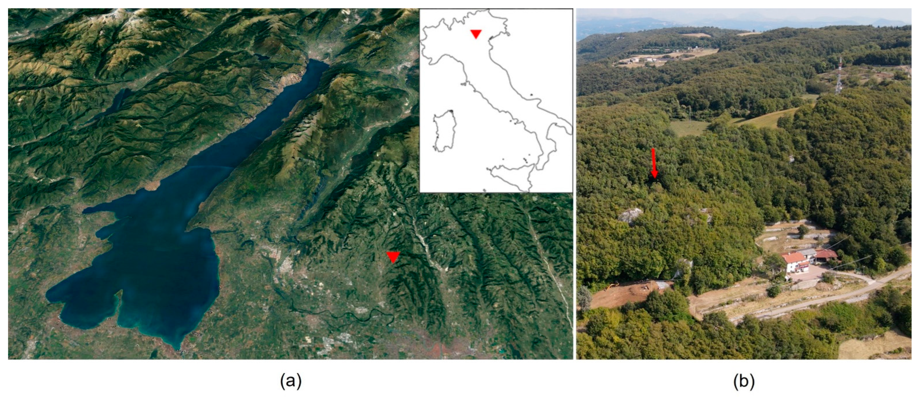
Figure 1. Colombare di Negrar: Location map. (a) The Garda Lake area in Italy; the basemap is a modified satellite image provided by GoogleEarth™; (b) aerial photograph of the site in 2021 marked by the red arrow (photo by Angelo Cimarosti—Archeoreporter; September 2021).
Quaternary 05 00050 g001
Figure 2. Colombare di Negrar: (a) Stratigraphy and pollen samples taken from Trench 5; (b) Stratigraphy and pollen samples taken from Trench 4.
Quaternary 05 00050 g002
Figure 3. Colombare di Negrar: Pollen from Trench 5: (a) Avena/Triticum group, CNr21-3, SU 5, 44 µm; (b) Vitis, CNr20-3, SU 3, 22µm; (c) Tilia cordata/platyphyllos, CNr20-4, SU 4, 40 µm; (d) Tilia cordata/platyphyllos, CNr20-6, SU 6, 48 µm; (e) Juglans, CNr20-1, SU 3, 43 µm; (f) Corylus, CNr20-2, SU 3, 26 µm; (g) Corylus, CNr20-6, SU 6, 25 µm; (h) Cichorieae, CNr20-6, SU 6, 25 µm. The scale bar is 10 μm.
Quaternary 05 00050 g003
Figure 4. Colombare di Negrar: Percentage pollen diagram of Trench 5—2020; histograms show data from the 7 samples taken as drawn in Figure 2.
Quaternary 05 00050 g004
Figure 5. Colombare di Negrar: Percentage pollen diagram of Trench 4—2021; data are arranged in curves following the sequence of samples shown in Figure 2. Dark curves are the true values; grey curves represent the data enhanced ×10.
Quaternary 05 00050 g005
Figure 6. Colombare di Negrar: Principal Component Analysis (PCA) of pollen data from the two trenches (5 and 4). The first component separates pollen spectra along a forestation gradient from an “open landscape” to a “forested environment”, and the second one along a climatic gradient from a drier to a wetter and cool environment.
Quaternary 05 00050 g006
Table 1. Colombare di Negrar: List of pollen samples from the two trenches (5 and 4) excavated in the site (~4300–3500 cal BC).
TrenchPollen SampleArchaeological LabelUnitChronology
(cal BC 2σ)
Description
5CNr20-123 Grey silt-sandy layer, not heavily anthropized, containing remains of material culture: pottery, flint, lumps of clay probably resulting from the breaking up of structural planes such as hearths, faunal remains, and charred plant macroremains
CNr20-243
CNr20-3533957–3799
3941–3660
3765–3643
3651–3532
CNr20-414 interf. 3 Pre-site. Brown/yellowish loamy-clayey soil with limestone inclusions and charcoals. It is noticeably sloping, replicating the current slope of the forest. Possibly burned forest at the time of occupation.
CNr20-534Before SU 3 and 6
CNr20-666 Filling of US 5, consisting of loose soil with abundant rubble; it contains sparse cultural remains of flint, animal bones, and charred plant macroremains
CNr20-7764318–4074
4246–4064
3955–3810
3891–3711
4CNr21-0 Moss polster (current pollen rain)
CNr21-111 SU 1 Dark brown clayey silt layer, strongly bioturbated, with slip material and secondary deposit
CNr21-2
CNr21-3
CNr21-4
CNr21-5
CNr21-6
4
5
6
7
8
4
5
6
7
8
Copper AgeSU 4 Light grey silt-sandy layer extended throughout the area south of the bedrock
SU 5 Calcareous clayey layer of grey colour with yellow streaks south of bedrock.
SU 6 Dark brown sandy silt layer with white and yellow speckles and large-sized stones
US 7 Layer of predominantly sandy matrix of grey colour with medium and small stones
SU 8 Brown silty-sandy layer with charcoal and limestone intercalations
CNr21-799Late NeolithicSU 9 Yellowish-brown silty-clay layer
Evidence of settlement with pottery and faunal remains
CNr21-81414Before Late NeolithicPre-site
CNr21-91717
Table 2. Colombare di Negrar: List of macroremain samples from Trench 5.
TrenchMacroremain SampleUnitChronology
(cal BC 2σ)
Litres of Sediment
522-20
333957–3799
3941–3660
3765–3643
3651–3532
10
664318–4074
4246–4064
3955–3810
3891–3711
10
Publisher’s Note: MDPI stays neutral with regard to jurisdictional claims in published maps and institutional affiliations.