Detection and Characterisation of Eemian Marine Tephra Layers within the Sapropel S5 Sediments of the Aegean and Levantine Seas


Abstract
1. Introduction
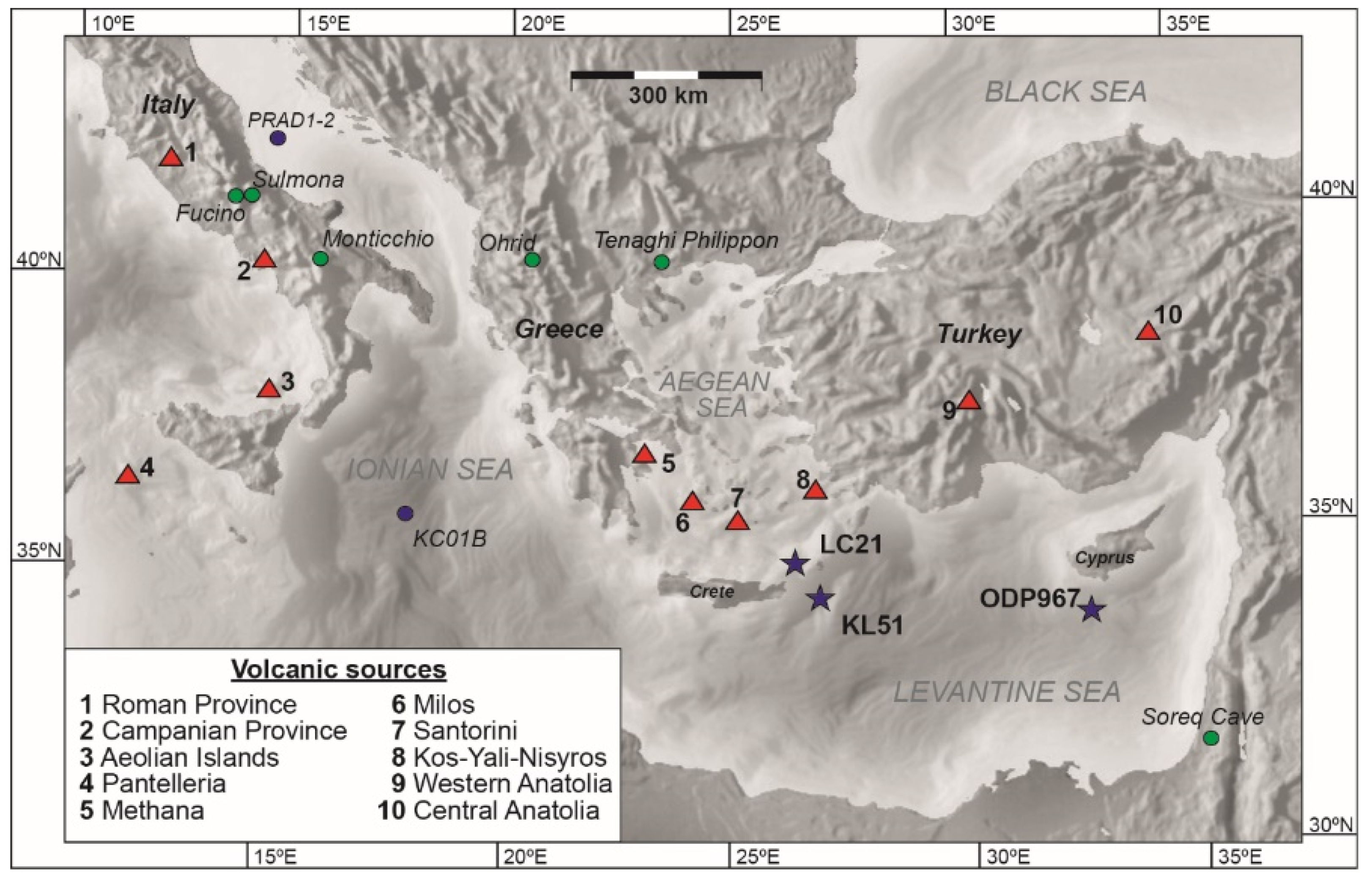
2. Materials and Sample Locations
2.1. ODP Site 967
2.2. Site LC21
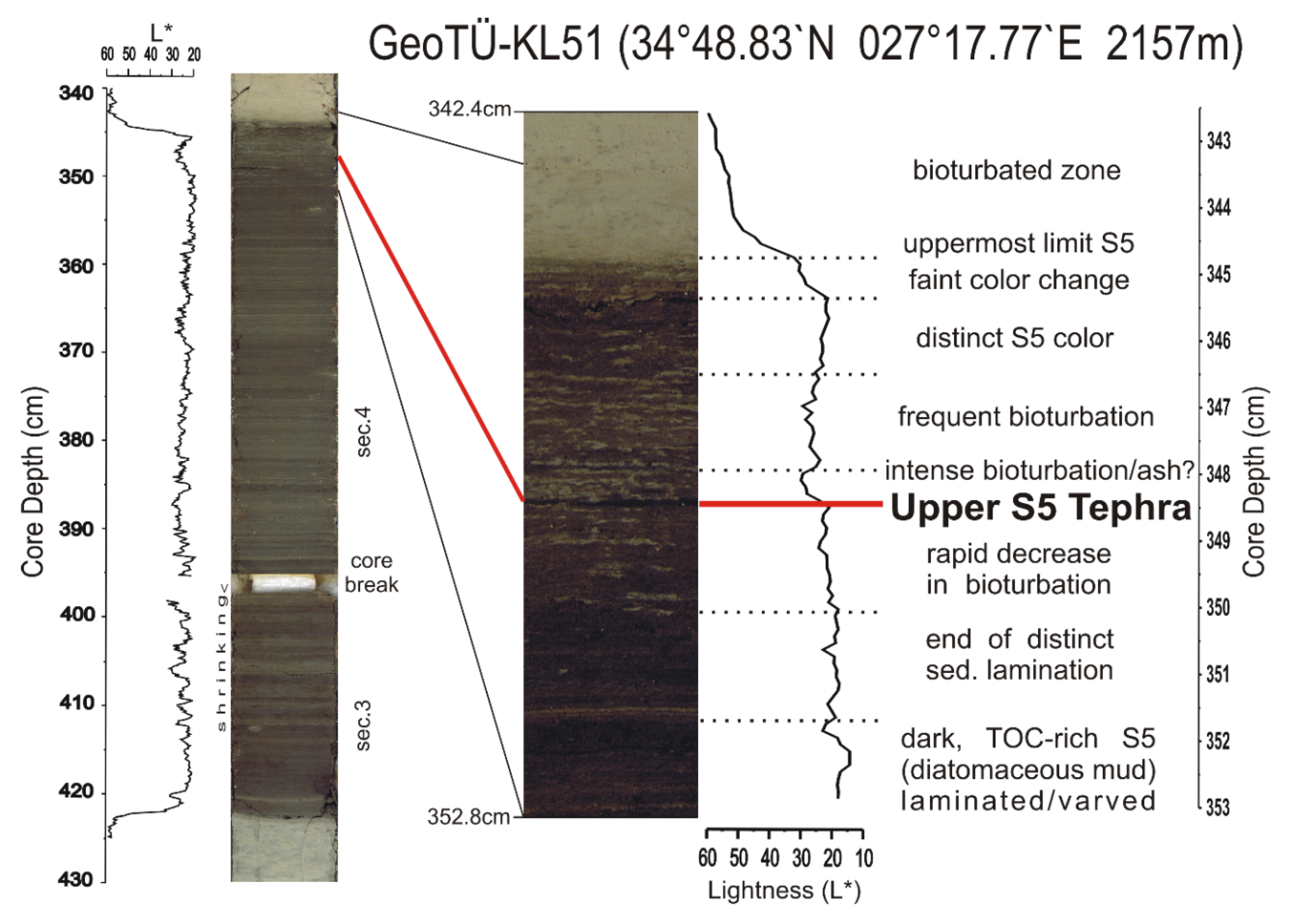
2.3. Site KL51
3. Analytical Methods
3.1. Tephra Sample Preparation (Cores ODP967B and LC21)
3.2. Visible Tephra Preparation (Core KL51)
3.3. Electron Probe Microanalysis (EPMA)
3.3.1. Samples from Cores LC21 and ODP967
3.3.2. Sample from Core KL51
3.4. Data Analysis
4. Results
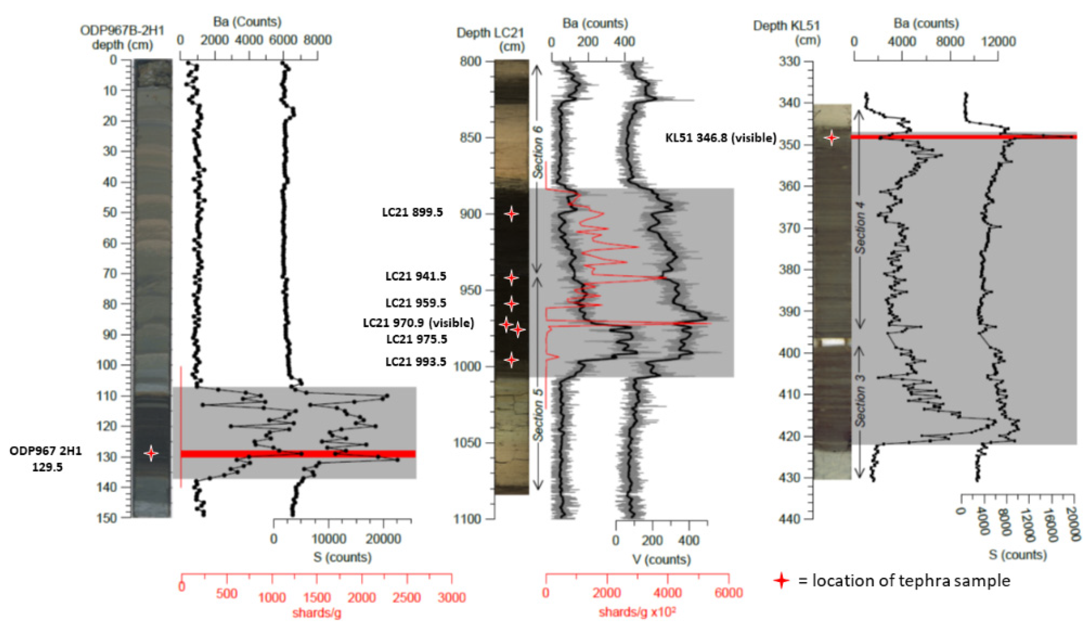
4.1. Geochemical Composition and Description of the ODP967B-2H1 129.5 Tephra
Sedimentological Context of Tephra ODP967B-2H1 129.5
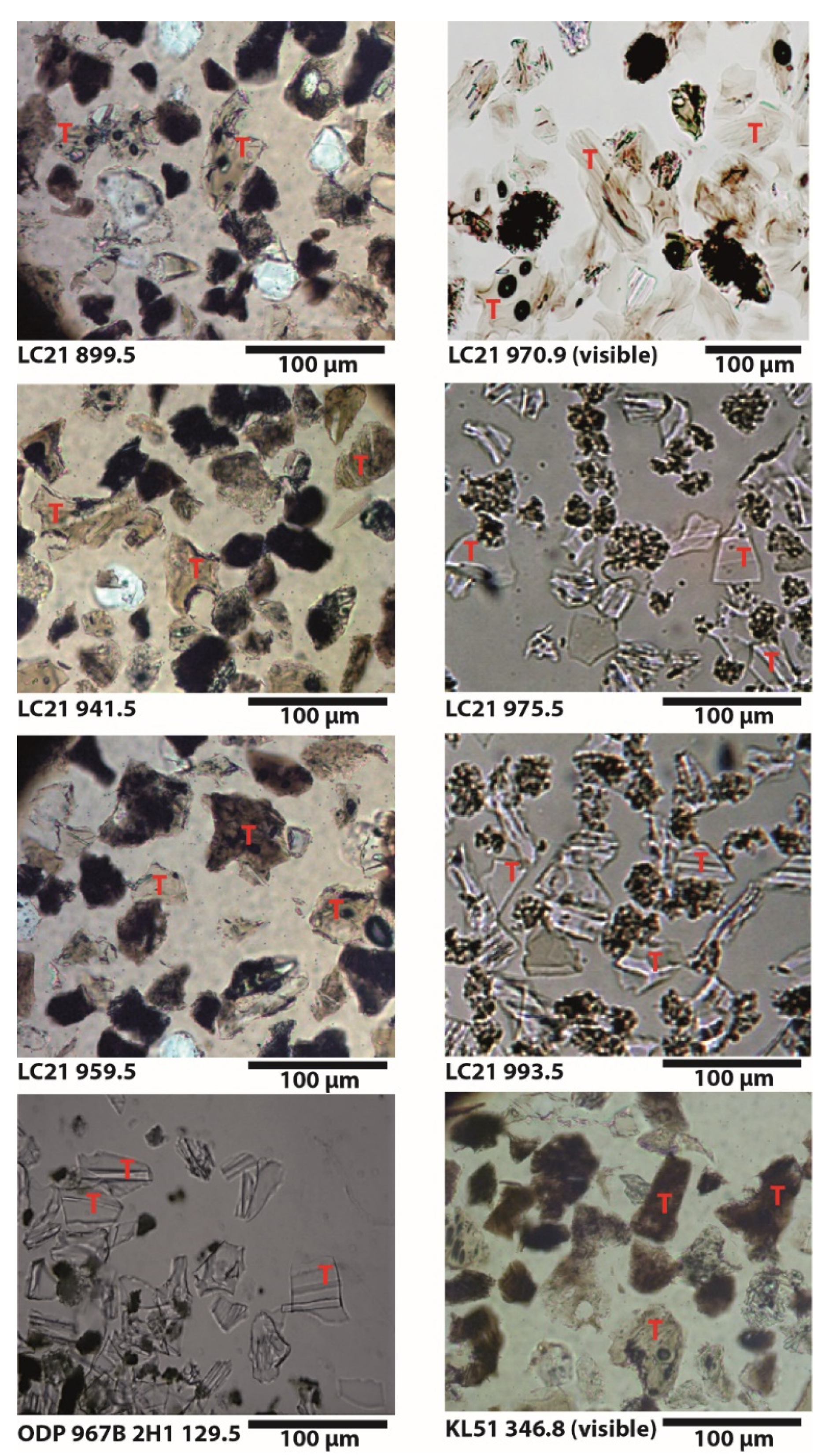
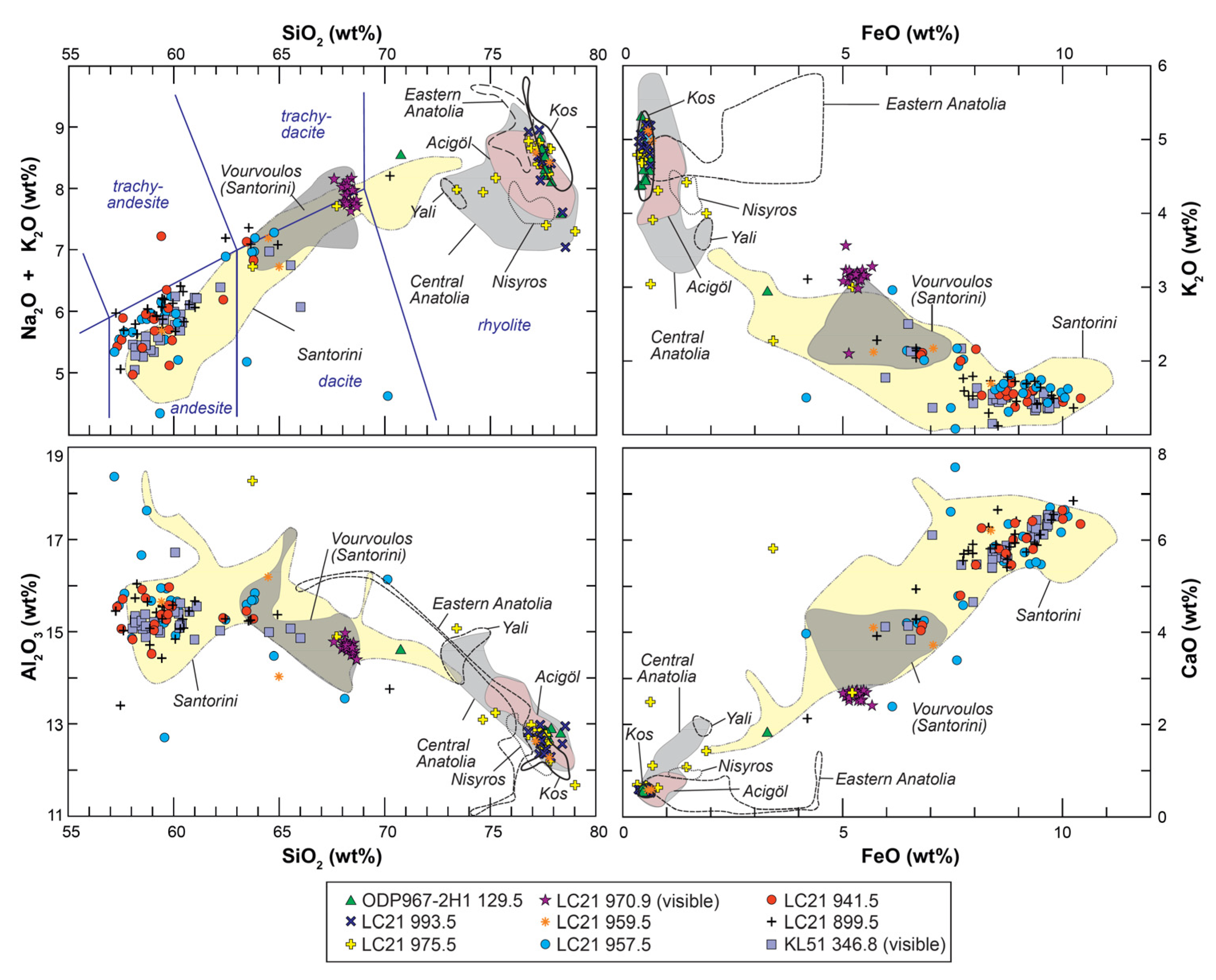
4.2. Geochemical Composition and Description of LC21 Tephra Samples
4.2.1. Cryptotephra LC21 993.5
4.2.2. Cryptotephra LC21 975.5
4.2.3. Visible Tephra LC21 970.9
4.2.4. Cryptotephras LC21 899.5, LC21 941.5 and LC21 959.5
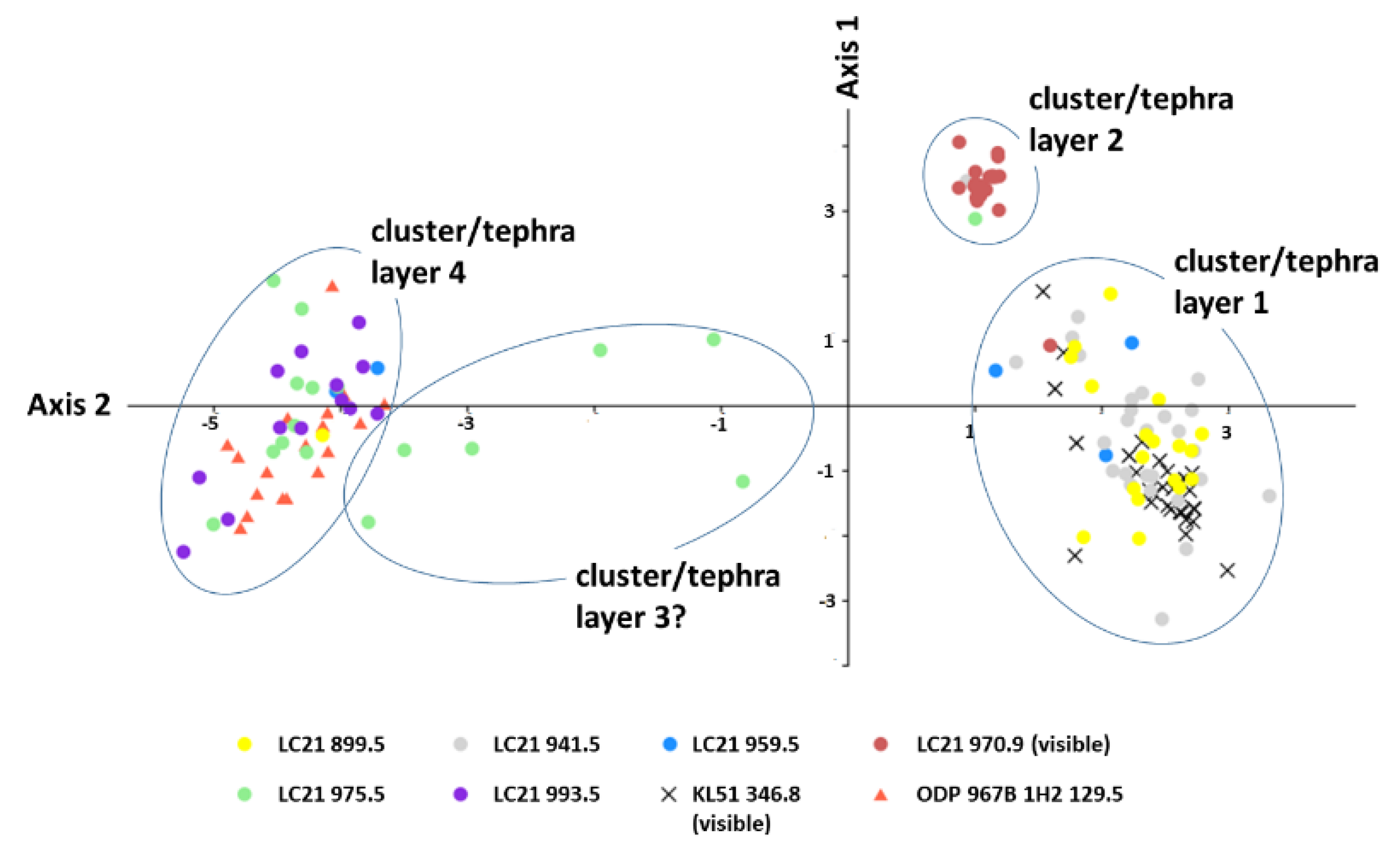
4.2.5. Sedimentological Context of LC21 Tephra Samples
- (1)
- The tephra was continuously erupted and deposited throughout the period of time in which the upper part of Sapropel S5 was formed. However, linear interpolation between the dates for the top and the bottom of the sapropel (121.5 ka and 128.3 ka respectively) in LC21 suggests a timespan of approximately 4000 to 5000 years for the period during which this spread of tephras was deposited; continuous eruption of geochemically homogeneous eruptive material over such a long time span seems highly unlikely.
- (2)
- The spread reflects reworking by burrowing animals. Reworking on this scale seems unlikely, as sapropels are formed by anoxia of bottom waters, which would not support a thriving community of sea bottom burrowers. Furthermore, a detailed oxygen isotope stratigraphy for LC21 based on foraminifera [21,54] appears to be intact and coherent (i.e., it is not a “noisy” signal), while the sediments consist of undisturbed laminations and the visible tephra layer at 970.9 cm in the same core shows no upward or downward reworking [17] (Figure 2). However, some limited reworking by burrowing may have occurred as indicated by tephra sample LC21 959.5 which contains a mix of glass components from primary over- and underlying tephras.
- (3)
- Prolonged deposition of tephra in the vicinity of LC21 could have been fed by reworked material removed from the trough slopes that surround the core site, in a similar manner to the process proposed by [81] which appears to generate “pseudo-isochrons” in deltaic sediments on a millennial timescale (see [81], Figure 5). In this process the reworked tephra shards (and other sediment grains) can be co-deposited with primary pelagic sediment for a long time after the eruption event.
4.3. Geochemical Composition and Description of the KL51 346.8 Tephra
Sedimentological Context of Tephra Sample KL51 346.8
5. Discussions
5.1. Correlations Between Cores and Possible Sources of the Tephra
5.2. Age Estimates of the Tephra Deposits
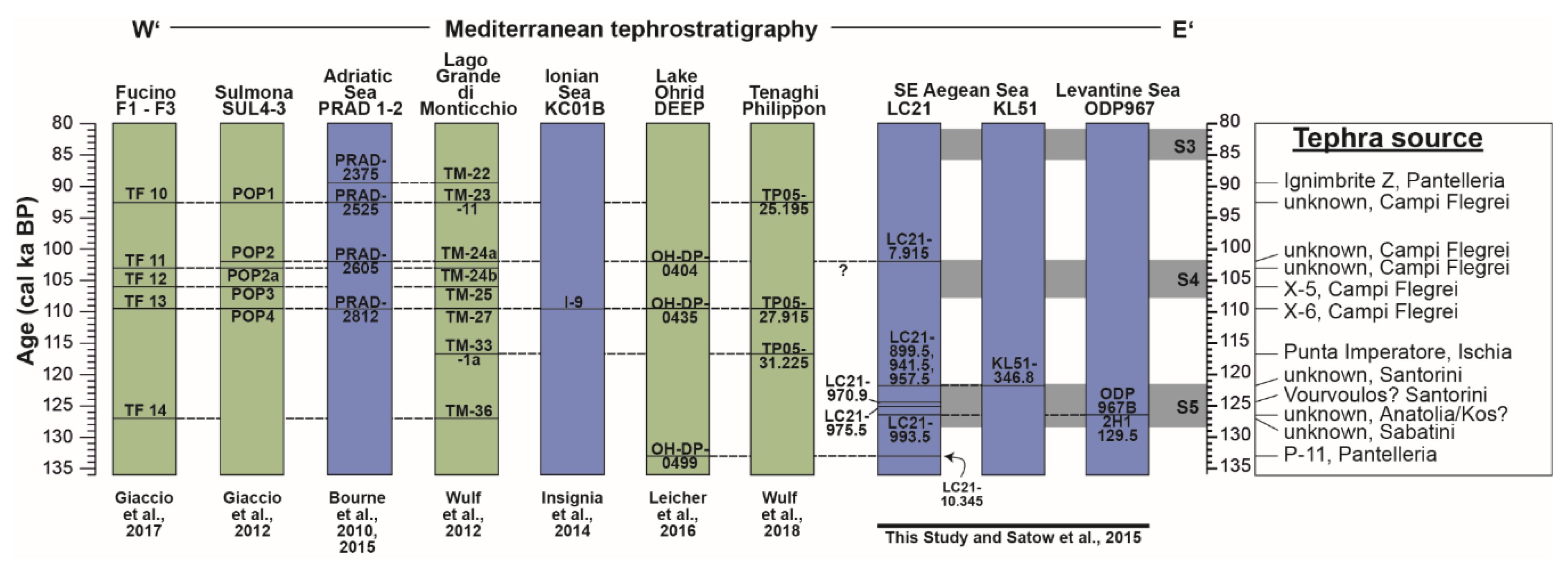
5.3. Synthesis with the Regional Tephrostratigraphy
6. Conclusions
Supplementary Materials
Author Contributions
Funding
Acknowledgments
Conflicts of Interest
References
- Lowe, J.; Barton, N.; Blockley, S.; Ramsey, C.B.; Cullen, V.; Davies, W.; Gamble, C.; Grant, K.; Hardiman, M.; Housley, R.; et al. Volcanic Ash layers illuminate the resilience of Neanderthals and early modern humans to natural hazards. Proc. Natl. Acad. Sci. USA 2012, 34, 13532–13537. [Google Scholar] [CrossRef]
- Lane, C.S.; Brauer, A.; Blockley, S.P.E.; Dulski, P. Volcanic ash reveals time-transgressive abrupt climate change during the Younger Dryas. Geology 2013, 41, 1251–1254. [Google Scholar] [CrossRef]
- Lane, C.S.; Lowe, D.J.; Blockley, S.P.E.; Suzuki, T.; Smith, V.C. Advancing tephrochronology as a global dating tool: Applications in volcanology, archaeology, and palaeoclimatology. Quat. Geochronol. 2017, 40, 1–7. [Google Scholar] [CrossRef]
- Wulf, S.; Keller, J.; Paterne, M.; Mingram, J.; Lauterbach, S.; Opitz, S.; Sottili, G.; Giaccio, B.; Albert, P.G.; Satow, C.; et al. The 100–133 ka record of Italian explosive volcanism and revised tephrochronology of Lago Grande di Monticchio. Quat. Sci. Rev. 2012, 58, 104–123. [Google Scholar] [CrossRef]
- Bourne, A.J.; Albert, P.G.; Matthews, I.P.; Trincardi, F.; Wulf, S.; Asioli, A.; Blockley, S.P.E.; Keller, J.; Lowe, J.J. Tephrochronology of core PRAD 1-2 from the Adriatic Sea: Insights into Italian explosive volcanism for the period 200–80ka. Quat. Sci. Rev. 2015, 116, 28–43. [Google Scholar] [CrossRef]
- Matthews, I.P.; Trincardi, F.; Lowe, J.J.; Bourne, A.J.; MacLeod, A.; Abbott, P.M.; Andersen, N.; Asioli, A.; Blockley, S.P.E.; Lane, C.S.; et al. Developing a robust tephrochronological framework for Late Quaternary marine records in the Southern Adriatic Sea: New data from core station SA03-11. Quat. Sci. Rev. 2015, 118, 84–104. [Google Scholar] [CrossRef]
- Allan, A.S.R.; Baker, J.A.; Carter, L.; Wysoczanksi, R.J. Reconstructing the Quaternary evolution of the world’s most active silicic volcanic system: Insights from an ~1.65 Ma deep ocean tephra record sourced from Taupo Volcanic Zone, New Zealand. Quat. Sci. Rev. 2008, 27, 2341–2360. [Google Scholar] [CrossRef]
- Paterne, M.; Guichard, F.; Duplessy, J.C.; Siani, G.; Sulpizio, R.; Labeyrie, J. A 90,000–200,000 yrs marine tephra record of Italian volcanic activity in the central Mediterranean Sea. J. Volcanol. Geoth. Res. 2008, 177, 187–196. [Google Scholar] [CrossRef]
- Lane, C.S.; Andric, M.; Cullen, V.; Blockley, S. The occurrence of distal Icelandic and Italian tephra in the Lateglacial of Lake Bled, Slovenia. Quat. Sci. Rev. 2011, 30, 1013–1018. [Google Scholar] [CrossRef]
- Albert, P.G.; Tomlinson, E.L.; Smith, V.C.; Di Roberto, A.; Todman, A.; Rosi, M.; Marani, M.; Müller, W.; Menzies, M.A. Marine-continental tephra correlations: Volcanic glass geochemistry from the Marsili Basin and the Aeolian Islands, South Tyrrhenian Sea, Italy. J. Volcanol. Geoth. Res. 2012, 229, 74–94. [Google Scholar] [CrossRef]
- Wall-Palmer, D.; Coussens, M.; Talling, P.J.; Jutzeler, M.; Cassidy, M.; Marchant, I.; Palmer, M.R.; Watt, S.F.L.; Smart, C.W.; Fisher, J.K.; et al. Late Pleistocene stratigraphy of IODP Site U1396 and compiled chronology offshore of south and south west Montserrat, Lesser Antilles. Geochem. Geophys. Geosyst. 2014, 15, 3000–3020. [Google Scholar] [CrossRef]
- Fontijn, K.; Rawson, H.; Van Daele, M.; Moernaut, J.; Abarzúa, A.M.; Heirman, K.; Bertrand, S.; Pyle, D.M.; Mather, T.A.; De Batist, M.; et al. Synchronisation of sedimentary records using tephra: A postglacial tephrochronological model for the Chilean Lake District. Quat. Sci. Rev. 2016, 137, 234–254. [Google Scholar] [CrossRef]
- Federman, A.N.; Carey, S.N. Electron Microprobe correlation of tephra layers from Eastern Mediterranean. Quat. Res. 1980, 13, 160–171. [Google Scholar] [CrossRef]
- Vinci, A. Distribution and chemical composition of Tephra layers from the Eastern Mediterranean abyssal sediments. Mar. Geol. 1985, 64, 143–155. [Google Scholar] [CrossRef]
- Aksu, A.E.; Jenner, G.; Hiscott, R.N.; Isler, E.B. Occurrence, stratigraphy and geochemistry of late Quaternary tephra layers in the Aegean Sea and Marmara Sea. Mar. Geol. 2008, 252, 174–192. [Google Scholar] [CrossRef]
- Çağatay, M.N.; Wulf, S.; Sancar, Ü.; Özmaral, A.; Vidal, L.; Henry, P.; Appelt, O.; Gasperini, L. The tephra record from the Sea of Marmara for the last ca. 70 ka and its palaeoceanographic implications. Mar. Geol. 2015, 361, 96–110. [Google Scholar] [CrossRef]
- Satow, C.; Tomlinson, E.L.; Grant, K.M.; Albert, P.G.; Smith, V.C.; Manning, C.J.; Ottolini, L.; Wulf, S.; Rohling, E.J.; Lowe, J.J.; et al. A new contribution to the Late Quaternary tephrostratigraphy of the Mediterranean: Aegean Sea core LC21. Quat. Sci. Rev. 2015, 117, 96–112. [Google Scholar] [CrossRef]
- Rohling, E.J.; Marino, G.; Grant, K.M. Mediterranean climate and oceanography, and the periodic development of anoxic events (sapropels). Earth-Sci. Rev. 2015, 143, 62–97. [Google Scholar] [CrossRef]
- Revel, M.; Ducassou, E.; Grousset, F.E.; Bernasconi, S.M.; Migeon, S.; Revillon, S.; Mascle, J.; Murat, A.; Zaragosi, S.; Bosch, D. 100,000 years of African monsoon variability recorded in sediments of the Nile margin. Quat. Sci. Rev. 2010, 29, 1342–1362. [Google Scholar] [CrossRef]
- Ziegler, M.; Tuenter, E.; Lourens, L.J. The precession phase of the boreal summer monsoon as viewed from the eastern Mediterranean (ODP Site 968). Quat. Sci. Rev. 2010, 29, 1481–1490. [Google Scholar] [CrossRef]
- Grant, K.M.; Grimm, R.; Mikolajewicz, U.; Marino, G.; Ziegler, M.; Rohling, E.J. The timing of Mediterranean sapropel deposition relative to insolation, sea-level and African monsoon changes. Quat. Sci. Rev. 2016, 140, 125–141. [Google Scholar] [CrossRef]
- Grant, K.M.; Rohling, E.J.; Westerhold, T.; Zabel, M.; Heslop, D.; Konijnendijk, T.; Lourens, L.J. A 3 million year index for North African humidity/aridity and the implication of potential pan-African Humid Periods. Quat. Sci. Rev. 2017, 171, 100–118. [Google Scholar] [CrossRef]
- Rohling, E.; Mayewski, P.; Abu-Zied, R.; Casford, J.; Hayes, A. Holocene atmosphere-ocean interactions: Records from Greenland and the Aegean Sea. Clim. Dynam. 2002, 18, 587–593. [Google Scholar]
- Casford, J.S.L.; Rohling, E.J.; Abu-Zied, R.H.; Fontanier, C.; Jorissen, F.J.; Leng, M.J.; Schmiedl, G.; Thomson, J. A dynamic concept for eastern Mediterranean circulation and oxygenation during sapropel formation. Palaeogeogr. Palaeoclimatol. Palaeoecol. 2003, 190, 103–119. [Google Scholar] [CrossRef]
- Van der Meer, M.T.J.; Baas, M.; Rijpstra, W.I.C.; Marino, G.; Rohling, E.J.; Sinninghe Damsteé, J.S.; Schouten, S. Hydrogen isotopic compositions of long-chain alkenones record freshwater flooding of the Eastern Mediterranean at the onset of sapropel deposition. Earth Planet. Sci. Lett. 2007, 262, 594–600. [Google Scholar] [CrossRef]
- Marino, G.; Rohling, E.J.; Rijpstra, W.I.C.; Sangiorgi, F.; Schouten, S.; Sinninghe Damsteé, J.S. Aegean Sea as driver of hydrographic and ecological changes in the eastern Mediterranean. Geol. Soc. Am. 2007, 35, 675–678. [Google Scholar] [CrossRef]
- Marino, G.; Rohling, E.J.; Sangiorgi, F.; Hayes, A.; Casford, J.L.; Lotter, A.F.; Kucera, H.; Brinkhuis, H. Early and middle Holocene in the Aegean Sea: Interplay between high and low latitude climate variability. Quat. Sci. Rev. 2009, 28, 3246–3262. [Google Scholar] [CrossRef]
- Siani, G.; Magny, M.; Paterne, M.; Debret, M.; Fontugne, M. Paleohydrology reconstruction and Holocene climate variability in the South Adriatic Sea. Clim. Past 2013, 9, 499–515. [Google Scholar] [CrossRef]
- Gogou, A.; Triantaphyllou, M.; Xoplaki, E.; Izdebski, A.; Parinos, C.; Dimiza, M.; Bouloubassi, I.; Luterbacher, J.; Kouli, K.; Martrat, B.; et al. Climate variability and socio-environmental changes in the northern Aegean (NE Mediterranean) during the last 1500 years. Quat. Sci. Rev. 2016, 136, 209–228. [Google Scholar] [CrossRef]
- Bourne, A.; Lowe, J.J.; Trincardi, F.; Asioli, A.; Blockley, S.P.E.; Wulf, S.; Matthews, I.P.; Piva, A.; Vigliotti, L. Distal tephra record for the last ca 105,000 years from core PRAD 1-2 in the central Adriatic Sea: Implications for marine tephrostratigraphy. Quat. Sci. Rev. 2010, 29, 3079–3094. [Google Scholar] [CrossRef]
- Damaschke, M.; Sulpizio, R.; Zanchetta, G.; Wagner, B.; Böhm, A.; Nowaczyk, N.R.; Rethemeyer, J.; Hilgers, A. Tephrostratigraphic studies on a sediment core from Lake Prespa in the Balkans. Clim. Past 2013, 9, 267–287. [Google Scholar] [CrossRef]
- Wulf, S.; Hardiman, M.; Staff, R.A.; Koutsodendris, A.; Appelt, O.; Blockley, S.P.E.; Lowe, J.J.; Manning, C.J.; Ottolini, L.; Schmitt, A.K.; et al. The marine isotope stage 1–5 cryptotephra record of Tenaghi Philippon, Greece: Towards a detailed tephrostratigraphic framework for the Eastern Mediterranean region. Quat. Sci. Rev. 2018, 186, 236–262. [Google Scholar] [CrossRef]
- Vakhrameeva, P.; Koutsodendris, A.; Wulf, S.; Fletcher, W.J.; Appelt, O.; Knipping, M.; Gertisser, R.; Trieloff, M.; Pross, J. The cryptotephra record of the Marine Isotope Stage 12 to 10 interval (460–335 ka) at Tenaghi Philippon, Greece: Exploring chronological markers for the Middle Pleistocene of the Mediterranean region. Quat. Sci. Rev. 2018, 200, 313–333. [Google Scholar] [CrossRef]
- Mellis, O. Volcanic ash-horizons in deep-sea sediments from the eastern Mediterranean. Deep-Sea Res. 1954, 2, 89–92. [Google Scholar] [CrossRef]
- Richardson, D.; Ninkovich, D. Use of K2O, Rb, Zr, and Y versus SiO2 in volcanic ash layers of the eastern Mediterranean to trace their source. Bull. Geol. Soc. Am. 1976, 87, 110–116. [Google Scholar] [CrossRef]
- Cita, M.B.; Vergnaud-Grazzini, C.; Robert, C.; Chamley, H.; Ciaranfi, N.; d’Onofrio, S. Paleoclimatic record of a long deep sea core from the eastern Mediterranean. Quat. Res. 1977, 8, 205–235. [Google Scholar] [CrossRef]
- Keller, J.; Ryan, W.B.F.; Ninkovich, D.; Altherr, R. Explosive volcanic activity in the Mediterranean over the past 20,000 year as recorded in deep sea sediments. Geol. Soc. Am. Bull. 1978, 89, 591–604. [Google Scholar] [CrossRef]
- Sparks, R.S.J.; Brazier, S.; Huang, T.C.; Muerdter, D. Sedimentology of the Minoan Deep-Sea Tephra layer in the Aegean and Eastern Mediterranean. Mar. Geol. 1983, 54, 131–167. [Google Scholar] [CrossRef]
- Vinci, A. Chemical differences between the island and submarine pumice layers of Thera. Mar. Geol. 1984, 55, 487–491. [Google Scholar] [CrossRef]
- Narcisi, B.; Vezzoli, L. Quaternary stratigraphy of distal tephra layers in the Mediterranean—An overview. Global. Planet. Chang. 1999, 21, 31–50. [Google Scholar] [CrossRef]
- Calanchi, N.; Cattaneo, A.; Dinelli, E.; Gasparotto, G.; Lucchini, F. Tephra layers in Late Quaternary sediments of the central Adriatic Sea. Mar. Geol. 1998, 149, 191–209. [Google Scholar] [CrossRef]
- Siani, G.; Paterne, M.; Michel, E.; Sulpizio, R.; Sbrana, A.; Arnold, M.; Haddad, G. Mediterranean sea surface radiocarbon reservoir age changes since the Last Glacial Maximum. Science 2001, 294, 1917–1920. [Google Scholar] [CrossRef] [PubMed]
- Siani, G.; Sulpizio, R.; Paterne, M.; Sbrana, A. Tephrostratigraphy study for the last 18,000 14C years in a deep-sea sediment sequence for the South Adriatic. Quat. Sci. Rev. 2004, 23, 2485–2500. [Google Scholar] [CrossRef]
- Paterne, M.; Guichard, F.; Labeyrie, J.; Gillot, P.; Duplessy, J.C. Tyrrhenian Sea tephrochronology of the oxygen isotope record for the past 60,000 years. Mar. Geol. 1986, 72, 259–285. [Google Scholar] [CrossRef]
- Paterne, M.; Guichard, F.; Labeyrie, J. Explosive activity of the South Italian volcanoes during the past 80,000 years as determined by marine tephrochronology. J. Volcanol. Geoth. Res. 1988, 34, 153–172. [Google Scholar] [CrossRef]
- Insinga, D.D.; Tamburrino, S.; Lirer, F.; Vezzoli, L.; Barra, M.; De Lange, G.J.; Tiepolo, M.; Vallefuoco, M.; Mazzola, S.; Sprovieri, M. Tephrochronology of the astronomically-tuned KC01B deep-sea core, Ionian Sea: Insights into the explosive activity of the Central Mediterranean area during the last 200 ka. Quat. Sci. Rev. 2014, 85, 63–84. [Google Scholar] [CrossRef]
- Crocitti, M.; Sulpizio, R.; Insinga, D.D.; De Rosa, R.; Donato, P.; Iorio, M.; Zanchetta, G.; Barca, D.; Lubritto, C. On ash dispersal from moderately explosive volcanic eruptions: Examples from Holocene and Late Pleistocene eruptions of Italian volcanoes. J. Volcanol. Geoth. Res. 2019, 385, 198–221. [Google Scholar] [CrossRef]
- Tomlinson, E.L.T.; Smith, V.; Albert, P.G.; Aydar, E.; Civetta, L.; Cioni, R.; Çubukçu, E.; Gertisser, R.; Isaia, R.; Menzies, M.A.; et al. The major and trace element glass composition of the productive Mediterranean volcanic sources: Tools for correlating distal tephra layers in and around Europe. Quat. Sci. Rev. 2015, 118, 48–66. [Google Scholar] [CrossRef]
- Hamann, Y.; Wulf, S.; Ersoy, O.; Ehrmann, W.; Aydar, E.; Schmiedl, G. First evidence of a distal early Holocene ash layer in Eastern Mediterranean deep-sea sediments derived from the Anatolian province. Quat. Res. 2010, 73, 497–506. [Google Scholar] [CrossRef]
- Clift, P.; Blusztajin, J. The trace-element characteristics of Aegean and Aeolian volcanic arc tephra. J. Volcanol. Geoth. Res. 1999, 92, 321–347. [Google Scholar] [CrossRef]
- Dacassou, E.; Capotanodi, L.; Murat, A.; Bernasconi, S.M.; Mulder, T.; Gonthier, E.; Migeon, S.; Duprat, J.; Giraudeau, J.; Mascale, J. Multiproxy Late Quaternary stratigraphy of the Nile deep-sea turbidite system—Towards a chronology of deep-sea terrigenous systems. Sediment. Geol. 2007, 200, 1–13. [Google Scholar] [CrossRef]
- Allen, S.R.; Cas, R.A.F. Rhyolitic fallout and pyroclastic density current deposits from a phreatoplinian eruption in the eastern Aegean Sea, Greece. J. Volcanol. Geoth. Res. 1998, 86, 219–251. [Google Scholar] [CrossRef]
- Allen, S.R.; Stadlbauer, E.; Keller, J. Stratigraphy of the Kos Plateau Tuff: Product of a major Quaternary explosive rhyolitic eruption in the eastern Aegean, Greece. Int. J. Earth Sci. 1999, 88, 132–156. [Google Scholar] [CrossRef]
- Grant, K.M.; Rohling, E.J.; Bar-Matthews, M.; Ayalon, A.; Medina-Elizalde, M.; Bronk-Ramsey, C.; Satow, C.; Roberts, A.P. Rapid coupling between ice volume and polar temperature over the past 150,000 years. Nature 2012, 491, 744–747. [Google Scholar] [CrossRef]
- Cane, T.; Rohling, E.J.; Kemp, A.E.S.; Cooke, S.; Pearce, R.B. High-resolution stratigraphic framework for Mediterranean sapropel S: Defining temporal relationship between records of Eemian climate variability. Palaeogeogr. Palaeoclimatol. Palaeoecol. 2002, 183, 87–101. [Google Scholar] [CrossRef]
- Albert, P.G.; Smith, V.C.; Susuki, T.; Tomlinson, E.L.; Nakagawa, T.; Mclean, D.; Yamada, M.; Staff, R.A.; Schlolout, G.; Takemura, K.; et al. Constraints on the frequency and dispersal of explosive eruptions at Sambe and Daisen volcanoes (South-West Japan Arc) from the distal Lake Suigetsu record (SG06 core). Earth Sci. Rev. 2019, 185, 1004–1028. [Google Scholar] [CrossRef]
- Wulf, S.; Keller, J.; Satow, C.; Gertisser, R.; Kraml, M.; Grant, K.M.; Appelt, O.; Vakhrameeva, P.; Koutsodendris, A.; Hardiman, M.; et al. Advancing Santorini’s tephrostratigraphy: New glass geochemical data and improved marine-terrestrial tephra correlations for the past ~360 kyrs. Earth Sci. Rev. 2020, 200, 102964. [Google Scholar] [CrossRef]
- Tomlinson, E.L.; Kinvig, H.S.; Smith, V.C.; Blundy, J.D.; Gottsmann, J.; Müller, W.; Menzies, M.A. The Upper and Lower Nisyros Pumices: Revisions to the Mediterranean tephrostratigraphic record based on micron-beam glass geochemistry. J. Volcanol. Geoth. Res. 2012, 243–244, 69–80. [Google Scholar] [CrossRef]
- Keller, J.; Gertisser, R.; Reusser, E.; Dietrich, V. Pumice deposits of the Santorini Lower Pumice 2 eruption on Anafi island Greece: Indications for a Plinian event of exceptional magnitude. J. Volcanol. Geoth. Res. 2014, 278, 120–128. [Google Scholar] [CrossRef]
- Moller, T.; Schulz, H.; Hamann, Y.; Dellwig, O.; Kucera, M. Sedimentology and geochemistry of an exceptionally preserved last interglacial sapropel S5 in the Levantine Basin (Mediterranean Sea). Mar. Geol. 2012, 291, 34–48. [Google Scholar] [CrossRef]
- Grant, K.M.; Rohling, E.J.; Bronk Ramsey, C.; Cheng, H.; Edwards, F.; Florindo, F.; Heslop, D.; Marra, F.; Roberts, A.P.; Tamisiea, M.E.; et al. Sea-level variability over five glacial cycles. Nat. Commun. 2014, 5, 5076. [Google Scholar] [CrossRef] [PubMed]
- Emeis, K.C.; Robertson, A.H.F.; Richter, C. Shipboard crew of ODP leg 160. Chapter 8, Site 967. Proc. Ocean Drill. Program 1996, 160, 215–287. [Google Scholar]
- Emeis, K.C.; Schulz, H.M.; Struck, U.; Sakamoto, T.; Doose, H.; Erlenkeuser, H.; Howell, M.; Kroon, D.; Paterne, M. Stable isotope and alkenone temperature records of sapropels from sites 964 and 967: Constraining the physical environment of sapropel formation in the eastern Mediterranean Sea. Proc. Ocean Drill. Program Sci. Results 1998, 160, 309–331. [Google Scholar]
- Kroon, D.; Alexander, I.; Little, M.; Lourens, L.J.; Matthewson, A.; Robertson, A.H.F.; Sakamoto, T. Oxygen isotope and sapropel stratigraphy in the Eastern Mediterranean during the last 3.2 million years. Proc. Ocean Drill. Program 1998, 160, 181–189. [Google Scholar]
- De Rijk, S.; Hayes, A.; Rohling, E.J. Eastern Mediterranean sapropel S1 interruption: An expression of the onset of climatic deterioration around 7 ka BP. Mar. Geol. 1999, 153, 337–343. [Google Scholar] [CrossRef]
- Hayes, A.; Rohling, E.; De Rijk, S.; Kroon, D.; Zachariasse, W. Mediterranean planktonic foraminiferal faunas during the last glacial cycle. Mar. Geol. 1999, 153, 239–252. [Google Scholar] [CrossRef]
- Hieke, W.; Hemleben, C.; Linke, P.; Türkay, M.; Weikert, H. Mittelmeer 1998/99, Cruise No. 40, 28 October 1997–10 February 1998Mittelmeer 1998. In METEOR-Berichte; Universität Hamburg: Hamburg, Germany, 1999; p. 286. [Google Scholar]
- Blockley, S.P.E.; Pyne-O’Donnel, S.; Lowe, J.J.; Matthews, I.P.; Stone, A.; Pollard, A.M.; Turney, C.S.M.; Molyneux, E.G. A new and less destructive laboratory procedure for the physical separation of distal glass shards from sediments. Quat. Sci. Rev. 2005, 24, 1952–1960. [Google Scholar] [CrossRef]
- Jochum, K.P.; Stoll, B.; Herwig, K.; Willbold, M.; Hofmann, A.W.; Amini, M.; Aarburg, S.; Abouchami, W.; Hellebrand, E.; Mocek, B.; et al. MPI-DING reference glasses for in situ microanalysis: New reference values for element concentrations and isotope ratios. Geochem. Geophys. Geosyst. 2006, 7. [Google Scholar] [CrossRef]
- Pearce, N.J.S.; Bendall, C.A.; Westgate, J.A. Comment on “Some numerical considerations in the geochemical analysis of distal microtephra” by A.M. Pollard, S.P.E. Blockley and C.S. Lane. Appl. Geochem. 2008, 23, 1353–1364. [Google Scholar] [CrossRef]
- Hunt, J.B.; Hill, P.G. An inter-laboratory comparison of the electron probe microanalysis of glass geochemistry. Quat. Int. 1996, 34, 229–241. [Google Scholar] [CrossRef]
- Kuehn, S.C.; Froese, D.G.; Shane, P.A.R. INTAV Intercomparison Participants. The INTAV intercomparison of electron-beam microanalysis of glass by tephrochronology laboratories: Results and recommendations. Quat. Int. 2011, 246, 19–47. [Google Scholar] [CrossRef]
- Aitchison, J.; Barcelo-Vidal, C.; Pawlowsky-Glahn, V. Some comments on compositional data analysis in archaeometry, in particular the fallacies in Tangri and Wright’s dismissal of logratio analysis. Archaeometry 2002, 44, 295–304. [Google Scholar] [CrossRef][Green Version]
- Pollard, A.M.; Blockley SP, E.; Lane, C.S. Some numerical considerations in the geochemical analysis of distal microtephra. Appl. Geochem. 2006, 21, 1692–1714. [Google Scholar] [CrossRef]
- Hammer, Ø.; Harper, D.A.T.; Ryan, P.D. PAST: Paleontological statistics software package for education and data analysis. Palaeontol. Electron. 2001, 4, 1–9. Available online: https://palaeo-electronica.org/2001_1/past/issue1_01.htm (accessed on 12 March 2020).
- Ryan, P.D.; Hammer, Ø.; Harper, D.A.; Paul Ryan, D.D. PAST: Paleontological Statistics Software Package for Education and Data Analysis; Geological Museum: Copenhagen, Denmark, 2001; Available online: https://omictools.com/past-2-tool (accessed on 12 March 2020).
- Le Bas, M.J.; Le Maitre, R.W.; Streckeisen, A.; Zanettin, B. A chemical classification of volcanic rocks based on the total alkali-silica diagram. J. Petrol. 1985, 27, 745–750. [Google Scholar] [CrossRef]
- Schmincke, H.U.; Sumita, M. Impact of volcanism on the evolution of Lake Van (eastern Anatolia) III: Periodic (Nemrut) vs. episodic (Süphan) explosive eruptions and climate forcing reflected in a tephra gap between ca. 14 ka and ca. 30 ka. J. Volcanol. Geoth. Res. 2014, 285, 195–213. [Google Scholar] [CrossRef]
- Tryon, C.A.; Logan, M.A.V.; Mouralis, D.; Kuhn, S.; Slimak, L.; Balkan-Atli, N. Building a tephrostratigraphic framework for the Paleolithic of Central Anatolia, Turkey. J. Archaeol. Sci. 2009, 36, 637–652. [Google Scholar] [CrossRef]
- Menzel, D.; Schouten, S.; van Bergen, P.F.; Sinninghe Damsteé, J.S. Higher plant vegetation changes during Pliocene sapropel formation. Org. Geochem. 2004, 35, 1343–1353. [Google Scholar] [CrossRef]
- Kataoka, K.S.; Urabe, A.; Nagahashi, Y. Millennial-scale reworking of tephra in alluvial to shallow marine settings: Distinguishing pseudo-isochrons from genuine ones. Quat. Int. 2016, 397, 173–193. [Google Scholar] [CrossRef]
- Druitt, T.H.; Edwards, L.; Mellors, R.A.A.; Pyle, D.M.; Sparks, R.S.J.; Lanphere, M.; Davies, M.; Barriero, B. Santorini Volcano. Geol. Soc. Mem. 1999, 19. Available online: https://pubs.er.usgs.gov/publication/70094778 (accessed on 5 March 2020).
- Vespa, M.; Keller, J.; Gertisser, R. Interplinian explosive activity of Santorini volcano (Greece) during the past 150,000 years. J. Volcanol. Geoth Res. 2006, 153, 262–286. [Google Scholar] [CrossRef]
- Volentik, A.; Vanderkluysen, L.; Principe, C. Stratigraphy of the Caldera walls of Nisyros volcano, Greece. Eclogae Geolgicae Helv. 2002, 95, 223–235. [Google Scholar]
- Bachmann, O.; Schoene, B.; Schnyder, C.; Spikings, R. The 40Ar/39Ar and U/Pb dating of young rhyolites in the Kos-Nisyros volcanic complex, Eastern Aegean Arc, Greece: Age discordance due to excess 40Ar in biotite. Geochem. Geophys. Geosyst. 2010, 11. [Google Scholar] [CrossRef]
- Bachmann, O.; Deering, C.D.; Ruprecht, J.S.; Huber, C.; Skopelitis, A.; Schnyder, C. Evolution of silicic magmas in the Kos-Nisyros volcanic center, Greece: Cycles associated with caldera collapse. Contrib. Mineral. Petrol. 2012, 163, 151–166. [Google Scholar] [CrossRef]
- Klaver, M.; Mateev, S.; Berndt, J.; Lissenberg, C.J.; Vroon, P.Z. A mineral and cumulate perspective to magma differentiation at Nisyros volcano, Aegean arc. Contrib. Mineral. Petrol. 2017, 172, 95. [Google Scholar] [CrossRef]
- Bachmann, O.; Wallace, P.J.; Bourquin, J. The melt inclusion record from the rhyolitic Kos Plateau Tuff (Aegean Arc). Contrib. Mineral. Petrol. 2010, 159, 187–202. [Google Scholar] [CrossRef]
- Kuzucuoglu, C.; Pastre, J.-F.; Black, S.; Ercan, T.; Fontugne, M.; Guillou, H.; Hatté, C.; Karabiyikoglu, M.; Orth, P.; Türkecan, A. Identification and dating of tephra layers from Quaternary sedimentary sequences of Inner Anatolia, Turkey. J. Volcanol. Geoth. Res. 1998, 85, 152–172. [Google Scholar] [CrossRef]
- Giaccio, B.; Niespolo, E.M.; Pereira, A.; Nomade, S.; Renne, P.R.; Albert, P.G.; Arienzo, I.; Regattieri, E.; Wagner, B.; Zanchetta, G.; et al. First integrated tephrochronological record for the last ~190 kyr from the Fucino Quaternary lacustrine succession, central Italy. Quat. Sci. Rev. 2017, 158, 211–234. [Google Scholar] [CrossRef]
- Bar-Matthews, M.; Ayalon, A.; Gilmour, M.; Matthews, A.; Hawkesworth, C.J. Sea-land oxygen isotopic relationships from planktonic foraminifera and speleothems in the Eastern Mediterranean region and their implication for paleo rainfall during interglacial intervals. Geochim. Cosmochim. Acta 2003, 67, 3181–3199. [Google Scholar] [CrossRef]
- Giaccio, B.; Nomade, S.; Wulf, S.; Isaia, R.; Sottili, G.; Cayuoto, G.; Galli, P.; Messina, P.; Sposato, A.; Sulpizio, R.; et al. The late MIS 5 Mediterranean tephra markers: A reappraisal from peninsular Italy terrestrial records. Quat. Sci. Rev. 2012, 56, 31–45. [Google Scholar] [CrossRef]
- Leicher, N.; Zanchetta, G.; Sulpizio, R.; Giaccio, B.; Wagner, B.; Nomade, S.; Francke, A.; Del Carlo, P. First tephrostratigraphic results of the DEEP site record from Lake Ohrid (Macedonia and Albania). Biogeosciences 2016, 13, 2151–2178. [Google Scholar] [CrossRef]
- Marino, G.; Rohling, E.J.; Rodríguez-Sanz, L.; Grant, K.M.; Heslop, D.; Roberts, A.P.; Stanford, J.D.; Yu, J. Bipolar seesaw control on last interglacial sea level. Nature 2015, 522, 197–201. [Google Scholar] [CrossRef]


| Samples Comprising Tephra Layer (Figure 7) | Tephra Layer Number (Figure 6 and Figure 7) | TAS Classification of Tephra Layer (Figure 5) | Interpolated Age of Tephra Layer | Method of Age Interpolation | Suggested Sources for Tephra Layer (from Figure 5) |
|---|---|---|---|---|---|
| LC21 899.5, 941.5 and 959.5; KL 51 346.8 (visible) | 1 | Andesitic to dacitic | 121.8 ± 2 ka | Linear Interpolation between top (121.5 ka) and base (128.3 ka) of S5 in core KL51 | Santorini |
| LC21 970.9 (visible) | 1 | Dacitic to trachytic | >121.8 ± 2 ka <126.4 ± 2 ka | Youngest age constrained by KL51 346.8 (visible). Oldest age constrained by ODP967B 2H1 129.5 | Santorini (Vourvoulos eruption) |
| LC21 975.5 | 3? | Rhyolitic | >121.8 ± 2 ka <126.4 ± 2 ka | Youngest age constrained by KL51 346.8 (visible). Oldest age constrained by ODP967B 2H1 129.5 | Santorini, Kos/Yali/Nisyros, Central/Eastern Anatolia |
| LC21 993.5 and ODP967B 2H1 129.5 | 4 | Rhyolitic | >126.4 ± 2 ka | Linear Interpolation between top (121.5 ka) and base (128.3 ka) of S5 in core ODP967B 2H1 | Kos/Yali/Nisyros, Central/Eastern Anatolia |
© 2020 by the authors. Licensee MDPI, Basel, Switzerland. This article is an open access article distributed under the terms and conditions of the Creative Commons Attribution (CC BY) license (http://creativecommons.org/licenses/by/4.0/).
Share and Cite
Satow, C.; Grant, K.M.; Wulf, S.; Schulz, H.; Mallon, A.; Matthews, I.; Lowe, J. Detection and Characterisation of Eemian Marine Tephra Layers within the Sapropel S5 Sediments of the Aegean and Levantine Seas. Quaternary 2020, 3, 6. https://doi.org/10.3390/quat3010006
Satow C, Grant KM, Wulf S, Schulz H, Mallon A, Matthews I, Lowe J. Detection and Characterisation of Eemian Marine Tephra Layers within the Sapropel S5 Sediments of the Aegean and Levantine Seas. Quaternary. 2020; 3(1):6. https://doi.org/10.3390/quat3010006
Chicago/Turabian StyleSatow, Christopher, Katharine M. Grant, Sabine Wulf, Hartmut Schulz, Addison Mallon, Ian Matthews, and John Lowe. 2020. "Detection and Characterisation of Eemian Marine Tephra Layers within the Sapropel S5 Sediments of the Aegean and Levantine Seas" Quaternary 3, no. 1: 6. https://doi.org/10.3390/quat3010006
APA StyleSatow, C., Grant, K. M., Wulf, S., Schulz, H., Mallon, A., Matthews, I., & Lowe, J. (2020). Detection and Characterisation of Eemian Marine Tephra Layers within the Sapropel S5 Sediments of the Aegean and Levantine Seas. Quaternary, 3(1), 6. https://doi.org/10.3390/quat3010006