

Unmanned Aerial Vehicle Technology for Glaciology Research in the Third Pole
 ,
,
Abstract
1. Introduction
2. Method
2.1. The Eligibility Criteria
2.2. The Data Sources and Search Strategy
3. Results
3.1. Publications’ Characteristics
3.2. Glacier Monitoring
3.3. Glaciology Research
4. Discussion
4.1. Trends in UAV Technology for Glaciology Research
4.2. The Future Potential of UAV Technology for Glaciology Research
5. Conclusions
- (1)
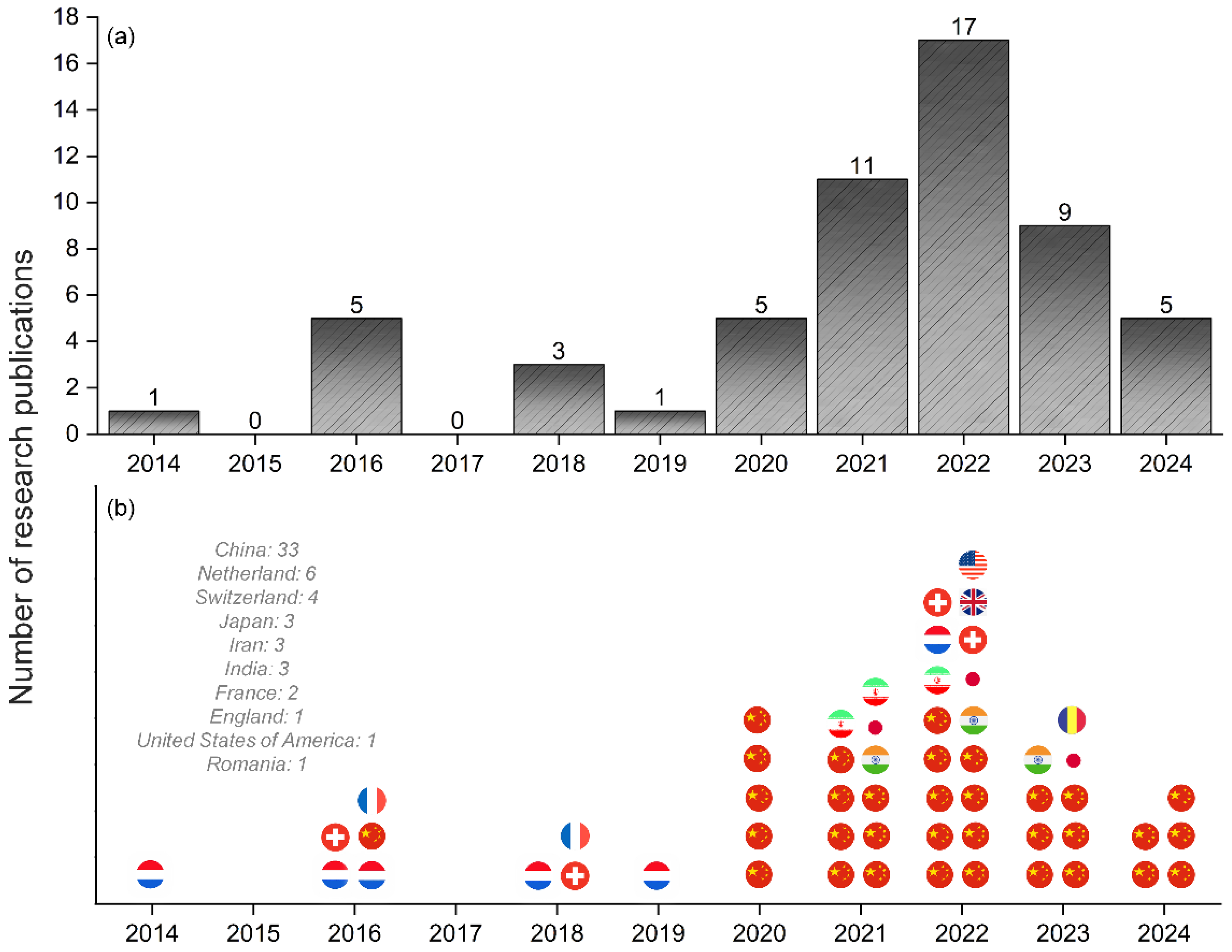
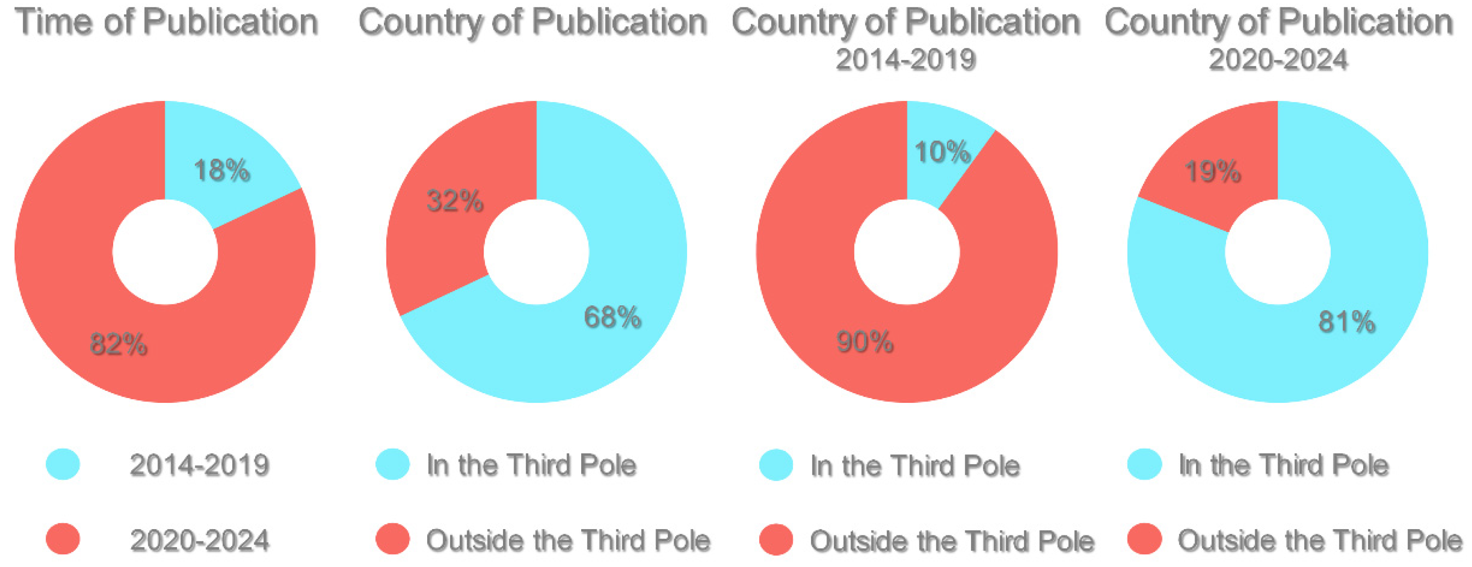
- A total of 57 articles in the related research area were published between 2014 and 2024. After 2020, the number of studies increased dramatically, with 82% of these publications emerging in the last five years. Research from Third Pole region countries accounted for nearly 70% over the past decade, while non-Third Pole countries contributed 30%. Since 2020, Third Pole countries have become the dominant contributors to this research field.
- (2)
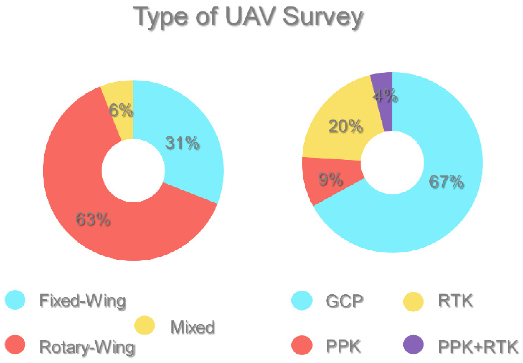
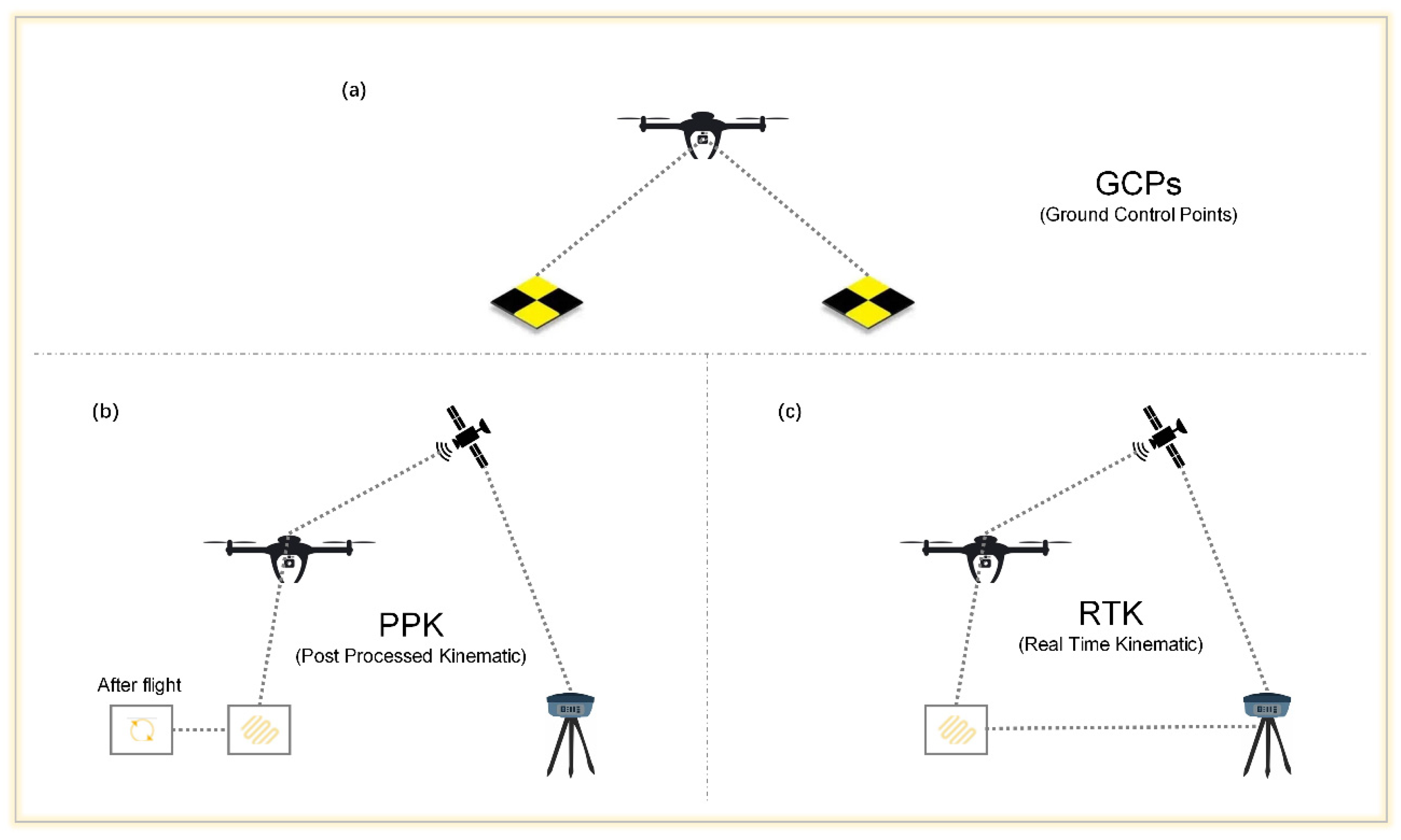
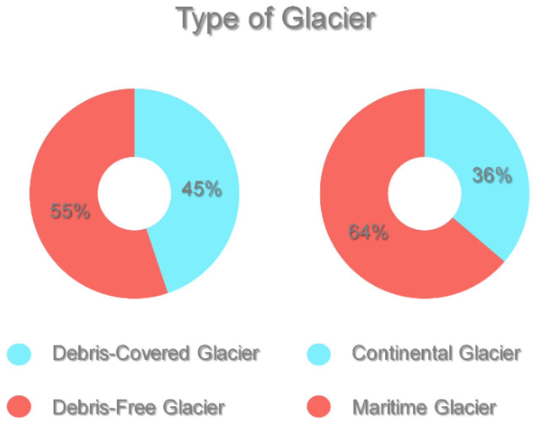
- The rotary-wing type of UAV dominates in its usage, accounting for 63% of deployments. GCPs are primarily employed, representing 67% of the usage, to ensure data accuracy. Related research has focused primarily on the Himalayan region, particularly on the Lirung Glacier in Nepal, with comparatively less focus on the western and central Third Pole areas. An analysis of the published articles indicated that 55% of the focus was on debris-free glaciers, whereas 45% was on debris-covered glaciers. Additionally, 64% were related to continental glaciers, whereas 36% were related to maritime glaciers.
- (3)
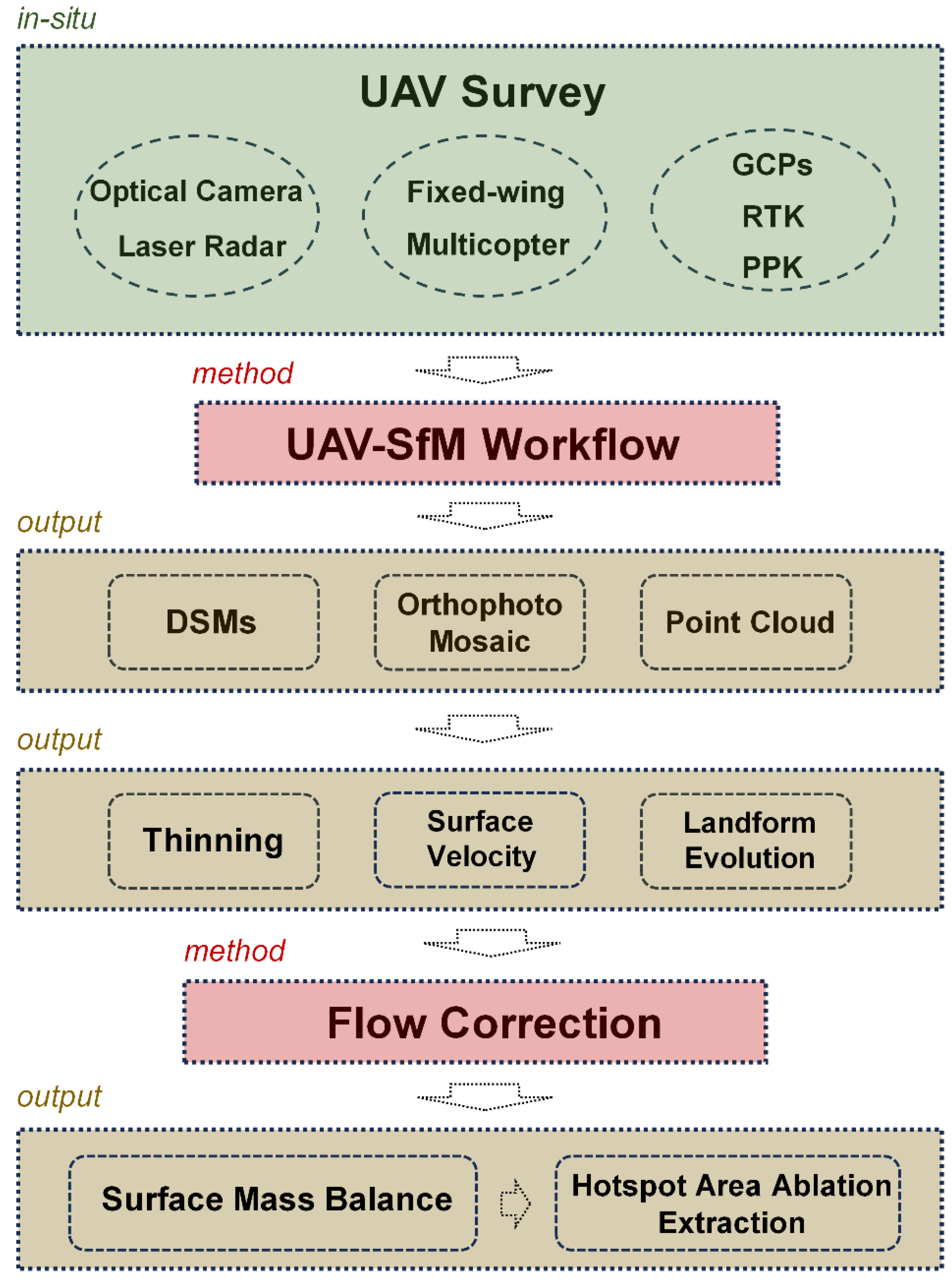
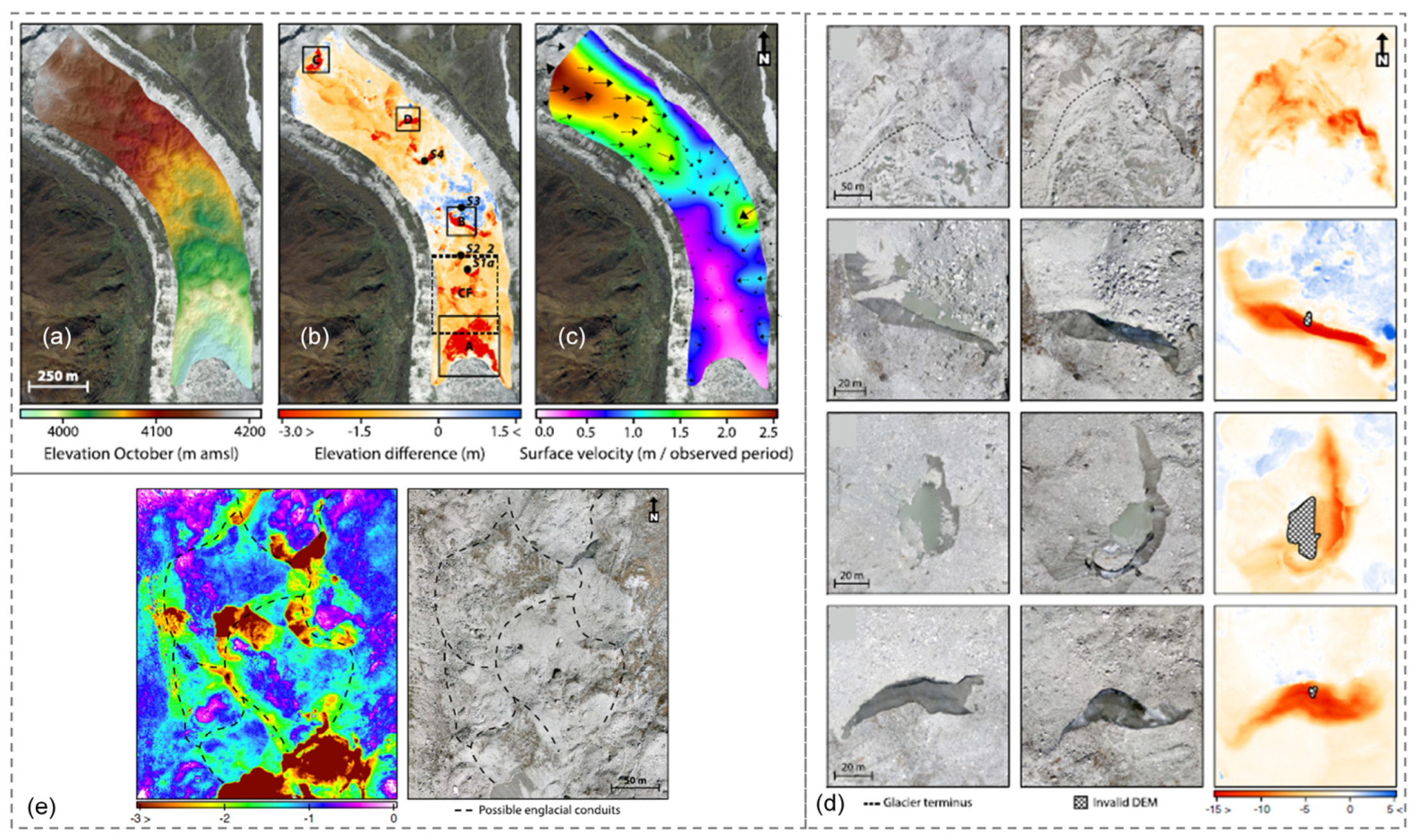
- Immerzeel [32] pioneered UAV applications in the Third Pole, laying the groundwork for future research. Since 2016, improved ice-flow correction methods have enhanced the surface mass balance measurements, facilitating insights into glacier responses to climate change. Debris-covered glaciers have become a key focus, with UAV data essential to ablation analyses in complex micro-geomorphic areas. Since 2018, UAV data have increasingly supported broader glacier change studies.
- (4)
- Emerging sensors, such as multispectral cameras, thermal infrared cameras, and LiDAR, offer the promise of enhanced monitoring capabilities. Advancements in battery technology are expected to improve UAVs’ efficiency and coverage, thereby enhancing our understanding of glacier dynamics and their responses to climate change. Furthermore, technologies such as AI may enhance UAV photogrammetry applications in glacier research in the Third Pole region.
Author Contributions
Funding
Conflicts of Interest
References
- Immerzeel, W.W.; Lutz, A.F.; Andrade, M.; Bahl, A.; Biemans, H.; Bolch, T.; Hyde, S.; Brumby, S.; Davies, B.J.; Elmore, A.C.; et al. Importance and vulnerability of the world’s water towers. Nature 2020, 577, 364–369. [Google Scholar] [PubMed]
- Yao, T.; Bolch, T.; Chen, D.; Gao, J.; Immerzeel, W.; Piao, S.; Su, F.; Thompson, L.; Wada, Y.; Wang, L.; et al. The imbalance of the Asian water tower. Nat. Rev. Earth. Environ. 2022, 3, 618–632. [Google Scholar]
- Yao, T.; Chen, F.; Cui, P.; Ma, Y.; Xu, B.; Zhu, L.; Zhang, F.; Wang, W.; Ai, L.; Yang, X. From Tibetan Plateau to Third Pole and Pan-Third Pole. Bull. Chin. Acad. Sci. 2017, 32, 924–931. [Google Scholar]
- Yao, T.; Thompson, L.; Yang, W.; Yu, W.; Gao, Y.; Guo, X.; Yang, X.; Duan, K.; Zhao, H.; Xu, B.; et al. Different glacier status with atmospheric circulations in Tibetan Plateau and surroundings. Nat. Clim. Change 2012, 2, 663–667. [Google Scholar]
- Brun, F.; Berthier, E.; Wagnon, P.; Kääb, A.; Treichler, D. A spatially resolved estimate of High Mountain Asia glacier mass balances from 2000 to 2016. Nat. Geosci. 2017, 10, 668–673. [Google Scholar]
- Dehecq, A.; Gourmelen, N.; Gardner, A.S.; Brun, F.; Goldberg, D.; Nienow, P.W.; Berthier, E.; Vincent, C.; Wagnon, P.; Trouvé, E. Twenty-first century glacier slowdown driven by mass loss in High Mountain Asia. Nat. Geosci. 2019, 12, 22–27. [Google Scholar]
- Bhattacharya, A.; Bolch, T.; Mukherjee, K.; King, O.; Menounos, B.; Kapitsa, V.; Neckel, N.; Yang, W.; Yao, T.D. High Mountain Asian glacier response to climate revealed by multi-temporal satellite observations since the 1960s. Nat. Commun. 2021, 12, 4133. [Google Scholar] [PubMed]
- Miles, E.; McCarthy, M.; Dehecq, A.; Kneib, M.; Fugger, S.; Pellicciotti, F. Health and sustainability of glaciers in High Mountain Asia. Nat. Commun. 2021, 12, 2868. [Google Scholar]
- Chen, W.; Yao, T.; Zhang, G.; Woolway, R.I.; Yang, W.; Xu, F.; Zhou, T. Glacier Surface Heatwaves Over the Tibetan Plateau. Geophys. Res. Lett. 2023, 50, e2022GL101115. [Google Scholar]
- Ren, S.; Yao, T.; Yang, W.; Miles, E.; Zhao, H.; Zhu, M.; Li, S. Changes in glacier surface temperature across the Third Pole from 2000 to 2021. Remote Sens. Environ. 2024, 305, 114076. [Google Scholar]
- Fischer, A. Glaciers and climate change: Interpretation of 50 years of direct mass balance of Hintereisferner. Glob. Planet. Change 2010, 71, 13–26. [Google Scholar] [CrossRef]
- Racoviteanu, A.E.; Williams, M.W.; Barry, R.G. Optical Remote Sensing of Glacier Characteristics: A Review with Focus on the Himalaya. Sensors 2008, 8, 3355–3383. [Google Scholar] [CrossRef] [PubMed]
- Colomina, I.; Molina, P. Unmanned aerial systems for photogrammetry and remote sensing: A review. ISPRS J. Photogramm. Remote Sens. 2014, 92, 79–97. [Google Scholar] [CrossRef]
- Román, A.; Tovar-Sánchez, A.; Roque-Atienza, D.; Huertas, I.E.; Caballero, I.; Fraile-Nuez, E.; Navarro, G. Unmanned aerial vehicles (UAVs) as a tool for hazard assessment: The 2021 eruption of Cumbre Vieja volcano, La Palma Island (Spain). Sci. Total Environ. 2022, 843, 157092. [Google Scholar] [CrossRef]
- Bemis, S.P.; Micklethwaite, S.; Turner, D.; James, M.R.; Akciz, S.; Thiele, S.T.; Bangash, H.A. Ground-based and UAV-Based photogrammetry: A multi-scale, high-resolution mapping tool for structural geology and paleoseismology. J. Struct. Geol. 2014, 69, 163–178. [Google Scholar] [CrossRef]
- Hu, S.; Qiu, H.J.; Wang, X.G.; Gao, Y.; Wang, N.L.; Wu, J.; Yang, D.D.; Cao, M.M. Acquiring high-resolution topography and performing spatial analysis of loess landslides by using low-cost UAVs. Landslides 2018, 15, 593–612. [Google Scholar] [CrossRef]
- Cirillo, D.; Zappa, M.; Tangari, A.C.; Brozzetti, F.; Ietto, F. Rockfall Analysis from UAV-Based Photogrammetry and 3D Models of a Cliff Area. Drones 2024, 8, 31. [Google Scholar] [CrossRef]
- Groos, A.R.; Bertschinger, T.J.; Kummer, C.M.; Erlwein, S.; Munz, L.; Philipp, A. The Potential of Low-Cost UAVs and Open-Source Photogrammetry Software for High-Resolution Monitoring of Alpine Glaciers: A Case Study from the Kanderfirn (Swiss Alps). Geosciences 2019, 9, 356. [Google Scholar] [CrossRef]
- Wufu, A.; Chen, Y.; Yang, S.; Lou, H.; Wang, P.; Li, C.; Wang, J.; Ma, L. Changes in Glacial Meltwater Runoff and Its Response to Climate Change in the Tianshan Region Detected Using Unmanned Aerial Vehicles (UAVs) and Satellite Remote Sensing. Water 2021, 13, 1753. [Google Scholar] [CrossRef]
- Li, T.; Zhang, B.; Cheng, X.; Westoby, M.J.; Li, Z.; Ma, C.; Hui, F.; Shokr, M.; Liu, Y.; Chen, Z.; et al. Resolving Fine-Scale Surface Features on Polar Sea Ice: A First Assessment of UAS Photogrammetry Without Ground Control. Remote Sens. 2019, 11, 784. [Google Scholar] [CrossRef]
- Liao, X.; Xiao, Q.; Zhang, H. UAV remote sensing: Popularization and expand application development trend. J. Remote Sens. 2019, 23, 1046–1052. [Google Scholar]
- Gaffey, C.; Bhardwaj, A. Applications of Unmanned Aerial Vehicles in Cryosphere: Latest Advances and Prospects. Remote Sens. 2020, 12, 948. [Google Scholar] [CrossRef]
- Moher, D.; Liberati, A.; Tetzlaff, J.; Altman, D.G.; Group, P. Reprint--preferred reporting items for systematic reviews and meta-analyses: The PRISMA statement. Phys. Ther. 2009, 89, 873–880. [Google Scholar] [CrossRef] [PubMed]
- Jing, F.; Li, Z.; Qiao, S.; Zhang, J.; Olatosi, B.; Li, X. Using geospatial social media data for infectious disease studies: A systematic review. Int. J. Digital Earth 2023, 16, 130–157. [Google Scholar]
- Li, G.; Guo, J.; Shang, J.; Zhu, S. Qinghai-Tibet Plateau Glacier-DEM product derived from the Chinese stereo mapping satellites. Int. Arch. Photogramm. Remote Sens. Spat. Inf. Sci. 2024, 48, 311–316. [Google Scholar]
- LI, J.; Chen, X.; Bao, A.; Shen, Z.; Ji, S. Glacier hazard emergency monitoring of the Jiubie Peak in Kongur Mountains using unmanned aerial vehicle photogrammetry. Arid. Land Geogr. (Chin.) 2016, 39, 378–386. [Google Scholar]
- Che, Y.; Wang, S.; Yi, S.; Wei, Y.; Cai, Y. Summer Mass Balance and Surface Velocity Derived by Unmanned Aerial Vehicle on Debris-Covered Region of Baishui River Glacier No. 1, Yulong Snow Mountain. Remote Sens. 2020, 12, 3280. [Google Scholar] [CrossRef]
- Liu, Y.; Qin, X.; Guo, W.; Gao, S.; Chen, J.; Wang, L.; Li, S.; Jin, Z. Influence of the use of photogrammetric measurement precision on low-altitude micro-UAVs in the glacier region. J. Remote Sens. (Chin.) 2020, 24, 161–172. [Google Scholar]
- Zhao, C.; Yang, W.; Wang, Y.; Ding, B.; Xu, X. Changes in surface elevation and velocity of Parlung No.4 glacier in southeastern Tibetan Plateau: Monitoring by UAV technology. J. Beijing Norm. Univ. (Nat. Sci.) 2020, 56, 557–565. [Google Scholar]
- Fu, Y.; Liu, Q.; Liu, G.; Zhang, B.; Cai, J.; Wang, X.; Zhang, R. Monitoring glacier surface velocity and ablation using high-resolution UAV imagery. Acta Geogr. Sin. (Chin.) 2021, 76, 1245–1256. [Google Scholar]
- Xue, Y.; Jing, Z.; Kang, S. Application of Unmanned Aerial Vehicle in Glacier Change Monitoring: Taking the Xiao Dongkemadi Glacier in the Tanggula Mountains as an Example. Prog. Geogr. (Chin.) 2021, 40, 1590–1599. [Google Scholar] [CrossRef]
- Immerzeel, W.W.; Kraaijenbrink, P.D.A.; Shea, J.M.; Shrestha, A.B.; Pellicciotti, F.; Bierkens, M.F.P.; de Jong, S.M. High-resolution monitoring of Himalayan glacier dynamics using unmanned aerial vehicles. Remote Sens. Environ. 2014, 150, 93–103. [Google Scholar]
- Vincent, C.; Wagnon, P.; Shea, J.M.; Immerzeel, W.W.; Kraaijenbrink, P.; Shrestha, D.; Soruco, A.; Arnaud, Y.; Brun, F.; Berthier, E.; et al. Reduced melt on debris-covered glaciers: Investigations from Changri Nup Glacier, Nepal. Cryosphere 2016, 10, 1845–1858. [Google Scholar]
- Brun, F.; Buri, P.; Miles, E.S.; Wagnon, P.; Steiner, J.; Berthier, E.; Ragettli, S.; Kraaijenbrink, P.; Immerzeel, W.W.; Pellicciotti, F. Quantifying volume loss from ice cliffs on debris-covered glaciers using high-resolution terrestrial and aerial photogrammetry. J. Glaciol. 2016, 62, 684–695. [Google Scholar]
- Kraaijenbrink, P.D.A.; Meijer, S.W.; Shea, J.M.; Pellicciotti, F.; De Jong, S.M.; Immerzeel, W.W. Seasonal surface velocities of a Himalayan glacier derived by automated correlation of unmanned aerial vehicle imagery. Ann. Glaciol. 2016, 57, 103–113. [Google Scholar]
- Kraaijenbrink, P.D.A.; Shea, J.M.; Pellicciotti, F.; de Jong, S.M.; Immerzeel, W.W. Object-based analysis of unmanned aerial vehicle imagery to map and characterise surface features on a debris-covered glacier. Remote Sens. Environ. 2016, 186, 581–595. [Google Scholar]
- Brun, F.; Wagnon, P.; Berthier, E.; Shea, J.M.; Immerzeel, W.W.; Kraaijenbrink, P.D.A.; Vincent, C.; Reverchon, C.; Shrestha, D.; Arnaud, Y. Ice cliff contribution to the tongue-wide ablation of Changri Nup Glacier, Nepal, central Himalaya. Cryosphere 2018, 12, 3439–3457. [Google Scholar]
- Buri, P.; Pellicciotti, F. Aspect controls the survival of ice cliffs on debris-covered glaciers. Proc. Natl. Acad. Sci. USA 2018, 115, 4369–4374. [Google Scholar]
- Kraaijenbrink, P.D.A.; Shea, J.M.; Litt, M.; Steiner, J.F.; Treichler, D.; Koch, I.; Immerzeel, W.W. Mapping Surface Temperatures on a Debris-Covered Glacier With an Unmanned Aerial Vehicle. Front. Earth. Sci. 2018, 6, 64. [Google Scholar]
- van Woerkom, T.; Steiner, J.F.; Kraaijenbrink, P.D.A.; Miles, E.S.; Immerzeel, W.W. Sediment supply from lateral moraines to a debris-covered glacier in the Himalaya. Earth. Surf. Dynam. 2019, 7, 411–427. [Google Scholar]
- Che, Y.; Wang, S.; Liu, J. Application of Unmanned Aerial Vehicle (UAV) in the Glacier Region with Complex Terrain: A case study in Baishui River Glacier No.1 located in the Yulong Snow Mountain. J. Glaciol. Geocryol. (Chin.) 2020, 42, 1391–1399. [Google Scholar]
- Yang, W.; Zhao, C.; Westoby, M.; Yao, T.; Wang, Y.; Pellicciotti, F.; Zhou, J.; He, Z.; Miles, E. Seasonal Dynamics of a Temperate Tibetan Glacier Revealed by High-Resolution UAV Photogrammetry and In Situ Measurements. Remote Sens. 2020, 12, 2389. [Google Scholar] [CrossRef]
- Karimi, N.; Farokhnia, A.; Sheshangosht, S.; Bahreinimotlagh, M. Using UAV and satellite image data for analyzing the elevation change of debris-covered glaciers and its associated driving factors. Environ. Earth Sci. 2021, 80, 577. [Google Scholar] [CrossRef]
- Karimi, N.; Sheshangosht, S.; Roozbahani, R. High-resolution monitoring of debris-covered glacier mass budget and flow velocity using repeated UAV photogrammetry in Iran. Geomorphology 2021, 389, 107855. [Google Scholar] [CrossRef]
- Wu, K.; Liu, S.; Zhu, Y.; Xie, F.; Gao, Y. High-resolution monitoring of glacier dynamics based on unmanned aerial vehicle survey in the Meili Snow Mountain. Prog. Geogr. (Chin.) 2021, 40, 1581–1589. [Google Scholar] [CrossRef]
- Wang, P.; Li, H.; Li, Z.; Liu, Y.; Xu, C.; Mu, J.; Zhang, H. Seasonal Surface Change of Urumqi Glacier No. 1, Eastern Tien Shan, China, Revealed by Repeated High-Resolution UAV Photogrammetry. Remote Sens. 2021, 13, 3389. [Google Scholar] [CrossRef]
- Cao, B.; Guan, W.; Li, K.; Pan, B.; Sun, X. High-Resolution Monitoring of Glacier Mass Balance and Dynamics with Unmanned Aerial Vehicles on the Ningchan No. 1 Glacier in the Qilian Mountains, China. Remote Sens. 2021, 13, 2735. [Google Scholar] [CrossRef]
- Sato, Y.; Fujita, K.; Inoue, H.; Sunako, S.; Sakai, A.; Tsushima, A.; Podolskiy, E.A.; Kayastha, R.; Kayastha, R.B. Ice Cliff Dynamics of Debris-Covered Trakarding Glacier in the Rolwaling Region, Nepal Himalaya. Front. Earth. Sci. 2021, 9, 623623. [Google Scholar] [CrossRef]
- Guo, W.; Guo, X.; Liu, Y.; Li, J.; Shangguan, D.; Chen, L.; Ga, J. Ablation Patterns of the Debris Covered Tongue of Halong Glacier Revealed by Short Term Unmanned Aerial Vehicle Surveys. Front. Earth. Sci. 2021, 9, 740160. [Google Scholar] [CrossRef]
- Wei, T.; Shangguan, D.; Yi, S.; Ding, Y. Characteristics and controls of vegetation and diversity changes monitored with an unmanned aerial vehicle (UAV) in the foreland of the Urumqi Glacier No. 1, Tianshan, China. Sci. Total Environ. 2021, 771, 145433. [Google Scholar] [CrossRef]
- Ramsankaran, R.; Navinkumar, P.J.; Dashora, A.; Kulkarni, A.V. UAV-Based Survey of Glaciers in Himalayas: Challenges and Recommendations. J. Indian Soc. Remote Sens. 2021, 49, 1171–1187. [Google Scholar]
- Dhote, P.R.; Thakur, P.K.; Chouksey, A.; Srivastav, S.K.; Raghvendra, S.; Rautela, P.; Ranjan, R.; Allen, S.; Stoffel, M.; Bisht, S.; et al. Synergistic analysis of satellite, unmanned aerial vehicle, terrestrial laser scanner data and process-based modelling for understanding the dynamics and morphological changes around the snout of Gangotri Glacier, India. Geomorphology 2022, 396, 108005. [Google Scholar]
- Karimi, N.; Sheshangosht, S.; Farokhnia, A. Determining the spatio-temporal variability of glacier surface velocity using high-resolution satellite images and UAV data: Alamkuh glacier, Iran. Remote Sens. Lett. 2022, 13, 138–150. [Google Scholar]
- Xu, S.; Fu, P.; Quincey, D.; Feng, M.; Marsh, S.; Liu, Q. UAV-based geomorphological evolution of the Terminus Area of the Hailuogou Glacier, Southeastern Tibetan Plateau between 2017 and 2020. Geomorphology 2022, 411, 108293. [Google Scholar] [CrossRef]
- Sato, Y.; Fujita, K.; Inoue, H.; Sakai, A. Karma Land- to lake-terminating transition triggers dynamic thinning of a Bhutanese glacier. Cryosphere 2022, 16, 2643–2654. [Google Scholar]
- Liu, S.; Wang, F.; Xie, Y.; Xu, C.; Xue, Y.; Yue, X.; Wang, L. Quantifying the Artificial Reduction of Glacial Ice Melt in a Mountain Glacier (Urumqi Glacier No. 1, Tien Shan, China). Remote Sens. 2022, 14, 2802. [Google Scholar] [CrossRef]
- Racoviteanu, A.E.; Glasser, N.F.; Robson, B.A.; Harrison, S.; Millan, R.; Kayastha, R.B.; Kayastha, R. Recent Evolution of Glaciers in the Manaslu Region of Nepal From Satellite Imagery and UAV Data (1970–2019). Front. Earth. Sci. 2022, 9, 767317. [Google Scholar]
- Mishra, N.B.; Miles, E.S.; Chaudhuri, G.; Mainali, K.P.; Mal, S.; Singh, P.B.; Tiruwa, B. Quantifying heterogeneous monsoonal melt on a debris-covered glacier in Nepal Himalaya using repeat uncrewed aerial system (UAS) photogrammetry. J. Glaciol. 2022, 68, 288–304. [Google Scholar]
- Fu, Y.; Liu, Q.; Liu, G.X.; Zhang, B.; Zhang, R.; Cai, J.; Wang, X.; Xiang, W. Seasonal ice dynamics in the lower ablation zone of Dagongba Glacier, southeastern Tibetan Plateau, from multitemporal UAV images. J. Glaciol. 2022, 68, 636–650. [Google Scholar]
- Wu, K.; Liu, S.; Zhu, Y.; Xie, F.; Gao, Y.; Qi, M.; Miao, W.; Duan, S.; Han, F.; Grünwald, R. Monitoring the Surface Elevation Changes of a Monsoon Temperate Glacier with Repeated UAV Surveys, Mainri Mountains, China. Remote Sens. 2022, 14, 2229. [Google Scholar] [CrossRef]
- An, B.; Wang, W.; Yang, W.; Wu, G.; Guo, Y.; Zhu, H.; Gao, Y.; Bai, L.; Zhang, F.; Zeng, C.; et al. Process, mechanisms, and early warning of glacier collapse-induced river blocking disasters in the Yarlung Tsangpo Grand Canyon, southeastern Tibetan Plateau. Sci. Total Environ. 2022, 816, 151652. [Google Scholar] [CrossRef] [PubMed]
- Zhong, Y.; Liu, Q.; Westoby, M.; Nie, Y.; Pellicciotti, F.; Zhang, B.; Cai, J.; Liu, G.; Liao, H.; Lu, X. Intensified paraglacial slope failures due to accelerating downwasting of a temperate glacier in Mt. Gongga, southeastern Tibetan Plateau. Earth. Surf. Dynam. 2022, 10, 23–42. [Google Scholar] [CrossRef]
- Liu, Y.; Qin, D.; Jin, Z.; Li, Y.; Xue, L.; Qin, X. Dynamic Monitoring of Laohugou Glacier No. 12 with a Drone, West Qilian Mountains, West China. Remote Sens. 2022, 14, 3315. [Google Scholar] [CrossRef]
- Zhao, F.; Long, D.; Li, X.D.; Huang, Q.; Han, P. Rapid glacier mass loss in the Southeastern Tibetan Plateau since the year 2000 from satellite observations. Remote Sens. Environ. 2022, 270, 112853. [Google Scholar] [CrossRef]
- Li, H.; Wang, P.; Li, Z.; Jin, S.; Xu, C.; Liu, S.; Zhang, Z.; Xu, L. An Application of Three Different Field Methods to Monitor Changes in Urumqi Glacier No. 1, Chinese Tien Shan, During 2012-18. J. Glaciol. 2022, 68, 41–53. [Google Scholar]
- Kneib, M.; Miles, E.S.; Buri, P.; Fugger, S.; McCarthy, M.; Shaw, T.E.; Zhao, C.X.; Truffer, M.; Westoby, M.J.; Yang, W.; et al. Sub-seasonal variability of supraglacial ice cliff melt rates and associatedprocesses from time-lapse photogrammetry. Cryosphere 2022, 16, 4701–4725. [Google Scholar] [CrossRef]
- Jouberton, A.; Shaw, T.E.; Miles, E.; McCarthy, M.; Fugger, S.; Ren, S.; Dehecq, A.; Yang, W.; Pellicciotti, F. Warming-induced monsoon precipitation phase change intensifies glacier mass loss in the southeastern Tibetan Plateau. Proc. Natl. Acad. Sci. USA 2022, 119, e2109796119. [Google Scholar] [PubMed]
- Li, H.; Wang, P.; Li, Z.; Jin, S.; Xu, C.; Mu, J.; He, J.; Yu, F. Effect of topography on the changes of Urumqi Glacier No. 1 in the Chinese Tianshan Mountains. J. Arid. Land. 2022, 14, 719–738. [Google Scholar] [CrossRef]
- Sunako, S.; Fujita, K.; Izumi, T.; Yamaguchi, S.; Sakai, A.; Kayastha, R.B. Up-glacier propagation of surface lowering of Yala Glacier, Langtang Valley, Nepal Himalaya. J. Glaciol. 2023, 69, 425–432. [Google Scholar] [CrossRef]
- Xu, S.; Fu, P.; Quincey, D.; Feng, M.; Marsh, S.; Jia, T. Recent (2018-2021) glaciological, hydrological and geomorphological landscape changes of Hailuogou Glacier tongue, southeastern Tibetan Plateau. J. Maps. 2023, 19, 2147029. [Google Scholar] [CrossRef]
- Garg, S.; Navinkumar, P.J.; Godara, A.; Sahu, R.; Singh, D.K.; Ramsankaran, R. Remote sensing the evolution of debris-covered Panchi Nala-A glacier, India (1971-2021) from satellites and Unmanned Aerial Vehicles. Reg. Environ. Change. 2023, 23, 103. [Google Scholar]
- Zholdoshbekov, E.; Duishonakunov, M.; Du, Q.Y.; Voda, M. Assessing Glacier Boundaries in the Ala-Archa Valley of Kyrgyzstan by Using Sentinel-1 SAR Dataset and High-Resolution UAV Imagery. Remote Sens. 2023, 15, 1131. [Google Scholar] [CrossRef]
- Xie, Y.; Wang, F.; Xu, C.; Yue, X.; Yang, S. Applying Artificial Cover to Reduce Melting in Dagu Glacier in the Eastern Qinghai-Tibetan Plateau. Remote Sens. 2023, 15, 1755. [Google Scholar] [CrossRef]
- Wu, Y.; Zhang, W.; Zhang, S.; Mao, Z.; Chen, A.; Li, Z.; Zhang, Q.; Guo, Z.; Jiang, X.; Long, Y. Emerging Signal of Englacial Debris on One Clean Surface Glacier Based on High Spatial Resolution Remote Sensing Data in Northeastern Tibetan Plateau. Remote Sens. 2023, 15, 3899. [Google Scholar] [CrossRef]
- Zhao, C.; Yang, W.; Miles, E.; Westoby, M.; Kneib, M.; Wang, Y.; He, Z.; Pellicciotti, F. Thinning and surface mass balance patterns of two neighbouring debris-coveredglaciers in the southeastern Tibetan Plateau. Cryosphere 2023, 17, 3895–3913. [Google Scholar] [CrossRef]
- He, Z.; Yang, W.; Wang, Y.; Zhao, C.; Ren, S.; Li, C. Dynamic Changes of a Thick Debris-Covered Glacier in the Southeastern Tibetan Plateau. Remote Sens. 2023, 15, 357. [Google Scholar] [CrossRef]
- Zhang, T.; Yang, W.; Zhao, C.; Wang, Z.; He, Z.; Wang, Y.; Wu, G.; Li, J.; An, B. Changes of Kuoqionggangri No. 1 Glacier in the Nyainqêntanglha Mountains, Qinghai-Tibet Plateau. J. Glaciol. Geocryol. (Chin.) 2024, 46, 379–391. [Google Scholar]
- Wang, P.; Li, H.; Li, Z.; Xu, L.; Yu, F.; He, J.; Dai, Y.; Zhou, P.; Mu, J.; Yue, X. Rapid mass losses of Urumqi River Basin glaciers, eastern Tianshan Mountains revealed from multi-temporal DEMs, 1964-2021. Int. J. Digital Earth 2024, 17, 1964–2021. [Google Scholar]
- Zhao, C.; He, Z.; Kang, S.; Zhang, T.; Wang, Y.; Li, T.; He, Y.; Yang, W. Contrasting Changes of Debris-Free Glacier and Debris-Covered Glacier in Southeastern Tibetan Plateau. Remote Sens. 2024, 16, 918. [Google Scholar] [CrossRef]
- Li, L.; Yang, Y.; Wang, S.; Wang, C.; Wang, Q.; Chen, Y.; Wang, J.; Ai, S.; Che, Y. Yearly Elevation Change and Surface Velocity Revealed from Two UAV Surveys at Baishui River Glacier No. 1, Yulong Snow Mountain. Atmosphere 2024, 15, 231. [Google Scholar] [CrossRef]
- Westoby, M.J.; Brasington, J.; Glasser, N.F.; Hambrey, M.J.; Reynolds, J.M. ’Structure-from-Motion’ photogrammetry: A low-cost, effective tool for geoscience applications. Geomorphology 2012, 179, 300–314. [Google Scholar]
- Benoit, L.; Gourdon, A.; Vallat, R.; Irarrazaval, I.; Gravey, M.; Lehmann, B.; Prasicek, G.; Gräff, D.; Herman, F.; Mariethoz, G. A high-resolution image time series of the Gorner Glacier—Swiss Alps—Derived from repeated unmanned aerial vehicle surveys. Earth Syst. Sci. Data 2019, 11, 579–588. [Google Scholar]
- Harwin, S.; Lucieer, A. Assessing the Accuracy of Georeferenced Point Clouds Produced via Multi-View Stereopsis from Unmanned Aerial Vehicle (UAV) Imagery. Remote Sens. 2012, 4, 1573–1599. [Google Scholar] [CrossRef]
- Sanz-Ablanedo, E.; Chandler, J.H.; Rodríguez-Pérez, J.R.; Ordóñez, C. Accuracy of Unmanned Aerial Vehicle (UAV) and SfM Photogrammetry Survey as a Function of the Number and Location of Ground Control Points Used. Remote Sens. 2018, 10, 1606. [Google Scholar] [CrossRef]
- Sefercik, U.G.; Nazar, M. Consistency Analysis of RTK and Non-RTK UAV DSMs in Vegetated Areas. IEEE J. Sel. Top. Appl. Earth Obs. Remote Sens. 2023, 16, 5759–5768. [Google Scholar]
- Stroner, M.; Urban, R.; Reindl, T.; Seidl, J.; Broucek, J. Evaluation of the Georeferencing Accuracy of a Photogrammetric Model Using a Quadrocopter with Onboard GNSS RTK. Sensors 2020, 20, 2318. [Google Scholar] [CrossRef]
- Rosas, M.A.; Clapuyt, F.; Viveen, W.; Vanacker, V. Quantifying geomorphic change in Andean river valleys using UAV-PPK-SfM techniques: An example from the western Peruvian Andes. Geomorphology 2023, 435, 108766. [Google Scholar]
- Zhang, H.; Aldana-Jague, E.; Clapuyt, F.; Wilken, F.; Vanacker, V.; Van Oost, K. Evaluating the potential of post-processing kinematic (PPK) georeferencing for UAV-based structure-from-motion (SfM) photogrammetry and surface change detection. Earth Surf. Dynam. 2019, 7, 807–827. [Google Scholar]
- Cirillo, D.; Cerritelli, F.; Agostini, S.; Bello, S.; Lavecchia, G.; Brozzetti, F. Integrating Post-Processing Kinematic (PPK)-Structure-from-Motion (SfM) with Unmanned Aerial Vehicle (UAV) Photogrammetry and Digital Field Mapping for Structural Geological Analysis. ISPRS Int. J. Geo-Inf. 2022, 11, 437. [Google Scholar] [CrossRef]
- Pellicciotti, F.; Stephan, C.; Miles, E.; Herreid, S.; Immerzeel, W.W.; Bolch, T. Mass-balance changes of the debris-covered glaciers in the Langtang Himal, Nepal, from 1974 to 1999. J. Glaciol. 2015, 61, 373–386. [Google Scholar]
- Herreid, S.; Pellicciotti, F. The state of rock debris covering Earth’s glaciers. Nat. Geosci. 2020, 13, 621–627. [Google Scholar]
- Rounce, D.R.; Hock, R.; McNabb, R.W.; Millan, R.; Sommer, C.; Braun, M.H.; Malz, P.; Maussion, F.; Mouginot, J.; Seehaus, T.C.; et al. Distributed Global Debris Thickness Estimates Reveal Debris Significantly Impacts Glacier Mass Balance. Geophys. Res. Lett. 2021, 48, e2020GL091311. [Google Scholar] [PubMed]
- McCarthy, M.; Miles, E.; Kneib, M.; Buri, P.; Fugger, S.; Pellicciotti, F. Supraglacial debris thickness and supply rate in High-Mountain Asia. Commun. Earth. Environ. 2022, 3, 269. [Google Scholar]
- Zhang, Y.; Gu, J.; Liu, S.; Wang, X.; Jiang, Z.; Wei, J.; Zheng, Y. Spatial pattern of the debris-cover effect and its role in the Hindu Kush-Pamir-Karakoram-Himalaya glaciers. J. Hydrol. 2022, 615, 128613. [Google Scholar]
- Kneib, M.; Fyffe, C.L.; Miles, E.S.; Lindemann, S.; Shaw, T.E.; Buri, P.; McCarthy, M.; Ouvry, B.; Vieli, A.; Sato, Y.; et al. Controls on Ice Cliff Distribution and Characteristics on Debris-Covered Glaciers. Geophys. Res. Lett. 2023, 50, e2022GL102444. [Google Scholar] [CrossRef]
- Bisset, R.R.; Nienow, P.W.; Goldberg, D.N.; Wigmore, O.; Loayza-Muro, R.A.; Wadham, J.L.; Macdonald, M.L.; Bingham, R.G. Using thermal UAV imagery to model distributed debris thicknesses and sub-debris melt rates on debris-covered glaciers. J. Glaciol. 2023, 69, 981–996. [Google Scholar]
- Messmer, J.; Groos, A.R. A low-cost and open-source approach for supraglacial debris thickness mapping using UAV-based infrared thermography. Cryosphere 2024, 18, 719–746. [Google Scholar]
- Westoby, M.J.; Rounce, D.R.; Shaw, T.E.; Fyffe, C.L.; Moore, P.L.; Stewart, R.L.; Brock, B.W. Geomorphological evolution of a debris-covered glacier surface. Earth. Surf. Processes. Landforms. 2020, 45, 3431–3448. [Google Scholar]
- Bello, A.B.; Navarro, F.; Raposo, J.; Miranda, M.; Zazo, A.; Alvarez, M. Fixed-Wing UAV Flight Operation under Harsh Weather Conditions: A Case Study in Livingston Island Glaciers, Antarctica. Drones 2022, 6, 384. [Google Scholar] [CrossRef]
- Tjoelker, A.R.; Baraër, M.; Valence, E.; Charonnat, B.; Masse-Dufresne, J.; Mark, B.G.; McKenzie, J.M. Drone-Based Ground-Penetrating Radar with Manual Transects for Improved Field Surveys of Buried Ice. Remote Sens. 2024, 16, 2461. [Google Scholar] [CrossRef]
- Vivero, S.; Bodin, X.; Farias-Barahona, D.; Macdonell, S.; Schaffer, N.; Robson, B.A.; Lambiel, C. Combination of Aerial, Satellite, and UAV Photogrammetry for Quantifying Rock Glacier Kinematics in the Dry Andes of Chile (30°S) Since the 1950s. Front Remote Sens 2021, 2, 784015. [Google Scholar] [CrossRef]
- Bash, E.A.; Moorman, B.J.; Gunther, A. Detecting Short-Term Surface Melt on an Arctic Glacier Using UAV Surveys. Remote Sens. 2018, 10, 1547. [Google Scholar] [CrossRef]
- Zaman-Allah, M.; Vergara, O.; Araus, J.L.; Tarekegne, A.; Magorokosho, C.; Zarco-Tejada, P.J.; Hornero, A.; Albà, A.H.; Das, B.; Craufurd, P.; et al. Unmanned aerial platform-based multi-spectral imaging for field phenotyping of maize. Plant Methods 2015, 11, 35. [Google Scholar] [CrossRef] [PubMed]
- Yue, J.; Yang, G.; Li, C.; Li, Z.; Wang, Y.; Feng, H.; Xu, B. Estimation of Winter Wheat Above-Ground Biomass Using Unmanned Aerial Vehicle-Based Snapshot Hyperspectral Sensor and Crop Height Improved Models. Remote Sens. 2017, 9, 708. [Google Scholar] [CrossRef]
- Aguasca, A.; Acevo-Herrera, R.; Broquetas, A.; Mallorqui, J.J.; Fabregas, X. ARBRES: Light-Weight CW/FM SAR Sensors for Small UAVs. Sensors 2013, 13, 3204–3216. [Google Scholar] [CrossRef] [PubMed]
- Li, D.; Li, M. Research Advance and Application Prospect of UnmannedAerial Vehicle Remote Sensing System. Geomat. Inf. Sci. Wuhan Univ. 2014, 39, 505–513.s. [Google Scholar]
- Li, Y.; Qiao, G.; Popov, S.; Cui, X.; Florinsky, I.V.; Yuan, X.; Wang, L. Unmanned Aerial Vehicle Remote Sensing for Antarctic Research: A review of progress, current applications, and future use cases. IEEE Geosci. Remote Sens. Mag. 2023, 11, 73–93. [Google Scholar] [CrossRef]
- Zhang, Z.; Zhu, L. A Review on Unmanned Aerial Vehicle Remote Sensing: Platforms, Sensors, Data Processing Methods, and Applications. Drones 2023, 7, 398. [Google Scholar] [CrossRef]
- Garcia-Fernandez, M.; Alvarez-Narciandi, G.; Lopez, Y.A.; Andres, F.L.-H. Improvements in GPR-SAR imaging focusing and detection capabilities of UAV-mounted GPR systems. ISPRS J. Photogramm. Remote Sens. 2022, 189, 128–142. [Google Scholar] [CrossRef]
- Ruols, B.; Baron, L.; Irving, J. Development of a drone-based ground-penetrating radar system for efficient and safe 3D and 4D surveying of alpine glaciers. J. Glaciol. 2023, 69, 2087–2098. [Google Scholar] [CrossRef]


| Publication Time | Country of Leading Author’s Affiliation | Study Area | Supported Content from UAV Data | Journal | Reference |
|---|---|---|---|---|---|
| 2014 | The Netherlands | Lirung | Glacier Debris Changes | Remote Sensing of Environment | [32] |
| 2016 | France | Changri Nup | Glacier Debris Changes | The Cryosphere | [33] |
| 2016 | China | Jiubie | Glacial Disasters | Arid Land Geography (in Chinese) | [26] |
| 2016 | Switzerland | Lirung | Glacier Debris Changes | Journal of Glaciology | [34] |
| 2016 | The Netherlands | Lirung | Glacier Debris Changes | Annals of Glaciology | [35] |
| 2016 | The Netherlands | Langtang | Glacial Landforms | Remote Sensing of Environment | [36] |
| 2018 | France | Changri Nup | Glacier Debris Changes | The Cryosphere | [37] |
| 2018 | Switzerland | Lirung | Complementary to Other Research | Proceedings of the National Academy of Sciences | [38] |
| 2018 | The Netherlands | Lirung | Surface Temperature of Glaciers | Frontiers in Earth Science | [39] |
| 2019 | The Netherlands | Lirung | Glacial Landforms | Earth Surface Dynamics | [40] |
| 2020 | China | Baishui River No. 1 | Glacial Landforms | Journal of Glaciology and Geocryology (in Chinese) | [41] |
| 2020 | China | Laohugou No. 12 | GCP Distribution Layout | Journal of Remote Sensing (in Chinese) | [28]) |
| 2020 | China | Parlung No. 4 | Glacier Elevation Changes, Surface Velocity | Journal of Beijing Normal University (Natural Science) (in Chinese) | [29] |
| 2020 | China | Baishui River No. 1 | Glacier Elevation Changes, Surface Velocity | Remote Sensing | [27] |
| 2020 | China | Parlung No. 4 | Glacier Elevation Changes, Surface Velocity | Remote Sensing | [42] |
| 2021 | Iran | Alamkouh | Glacier Debris Changes | Environmental Earth Sciences | [43] |
| 2021 | Iran | Alamkouh | Glacier Debris Changes | Geomorphology | [44] |
| 2021 | China | Mingyong | Glacier Debris Changes | Progress in Geography (in Chinese) | [45] |
| 2021 | China | Dongkemadi | Glacier Elevation Changes | Progress in Geography (in Chinese) | [31] |
| 2021 | China | Gongba | Glacier Elevation Changes, Surface Velocity | Acta Geographica Sinica (in Chinese) | [30] |
| 2021 | China | Urumqi No. 1 | Glacier Elevation Changes, Surface Velocity | Remote Sensing | [46] |
| 2021 | China | Ningchan No. 1 | Glacier Elevation Changes, Terminus Changes | Remote Sensing | [47] |
| 2021 | Japan | Trakarding | Glacial Landforms | Frontiers in Earth Science | [48] |
| 2021 | China | Halong | Glacial Landforms | Frontiers in Earth Science | [49] |
| 2021 | China | Urumqi No. 1 | Complementary to Other Research | Science of the Total Environment | [50] |
| 2021 | India | East Rathong, Hamtah, and Panchinala | Glacial Landforms | Journal of the Indian Society of Remote Sensing | [51] |
| 2022 | India | Gangotri | Glacial Landforms | Geomorphology | [52] |
| 2022 | Iran | Alamkouh | Glacier Debris Changes | Remote Sensing Letters | [53] |
| 2022 | China | Hailuogou | Glacial Landforms | Geomorphology | [54] |
| 2022 | Japan | Thorthormi and Lugge | Glacier Elevation Changes, Surface Velocity | The Cryosphere | [55] |
| 2022 | China | Urumqi No. 1 | Complementary to Other Research | Remote Sensing | [56] |
| 2022 | The Netherlands | Lirung | Glacier Debris Changes | Frontiers in Earth Science | [57] |
| 2022 | The United States of America | Annapurna III | Glacier Debris Changes | Journal of Glaciology | [58] |
| 2022 | China | Dagongba | Glacier Debris Changes | Journal of Glaciology | [59] |
| 2022 | China | Melang | Glacial Landforms, Glacier Elevation Changes | Remote Sensing | [60] |
| 2022 | China | Sedongpu | Complementary to Other Research | Science of the Total Environment | [61] |
| 2022 | England | Manaslu | Glacier Elevation Changes, Surface Velocity | Frontiers in Earth Science | [57] |
| 2022 | China | Hailuogou | Glacial Landforms | Earth Surface Dynamics | [62] |
| 2022 | China | Laohugou No. 12 | Glacier Elevation Changes, Surface Velocity | Remote Sensing | [63] |
| 2022 | China | Parlung No. 4 | Complementary to Other Research | Remote Sensing of Environment | [64] |
| 2022 | China | Urumqi No. 1 | Glacier Mass Balance | Journal of Glaciology | [65] |
| 2022 | Switzerland | 24K, Langtang | Glacier Debris Changes | The Cryosphere | [66] |
| 2022 | Switzerland | Parlung No. 4 | Complementary to Other Research | Proceedings of the National Academy of Sciences | [67] |
| 2022 | China | Urumqi No. 1 | Complementary to Other Research | Journal of Arid Land | [68] |
| 2023 | Japan | Yala | Glacier Debris Changes | Journal of Glaciology | [69] |
| 2023 | China | Hailuogou | Glacier Debris Changes | Journal of Maps | [70] |
| 2023 | India | Panchi Nala-A | Glacier Mass Balance | Regional Environmental Change | [71] |
| 2023 | Romania | Ak-Sai | Complementary to Other Research | Remote Sensing | [72] |
| 2023 | China | Dagu No. 17 | Complementary to Other Research | Remote Sensing | [73] |
| 2023 | China | QiYi | Glacier Debris Changes | Remote Sensing | [74] |
| 2023 | China | 23K, 24K | Glacier Debris Changes | The Cryosphere | [75] |
| 2023 | China | Zhuxi | Glacier Debris Changes | Remote Sensing | [76] |
| 2024 | China | Kuoqionggangri | Glacier Elevation Changes, Surface Velocity | Journal of Glaciology and Geocryology (in Chinese) | [77] |
| 2024 | China | Urumqi No. 1-7 | Glacier Mass Balance | International Journal of Digital Earth | [78] |
| 2024 | China | Weigele Dangxiong | Complementary to Other Research | The International Archives of the Photogrammetry, Remote Sensing and Spatial Information Sciences | [25] |
| 2024 | China | Parlung No. 4, 24K | Glacier Elevation Changes, Surface Velocity | Remote Sensing | [79] |
| 2024 | China | Baishui River No. 1 | Glacier Elevation Changes, Surface Velocity | Atmosphere | [80] |
Disclaimer/Publisher’s Note: The statements, opinions and data contained in all publications are solely those of the individual author(s) and contributor(s) and not of MDPI and/or the editor(s). MDPI and/or the editor(s) disclaim responsibility for any injury to people or property resulting from any ideas, methods, instructions or products referred to in the content. |
© 2025 by the authors. Licensee MDPI, Basel, Switzerland. This article is an open access article distributed under the terms and conditions of the Creative Commons Attribution (CC BY) license (https://creativecommons.org/licenses/by/4.0/).
Share and Cite
Zhao, C.; Kang, S.; Fan, Y.; Wang, Y.; He, Z.; Tan, Z.; Gao, Y.; Zhang, T.; He, Y.; Fan, Y. Unmanned Aerial Vehicle Technology for Glaciology Research in the Third Pole. Drones 2025, 9, 254. https://doi.org/10.3390/drones9040254
Zhao C, Kang S, Fan Y, Wang Y, He Z, Tan Z, Gao Y, Zhang T, He Y, Fan Y. Unmanned Aerial Vehicle Technology for Glaciology Research in the Third Pole. Drones. 2025; 9(4):254. https://doi.org/10.3390/drones9040254
Chicago/Turabian StyleZhao, Chuanxi, Shengyu Kang, Yihan Fan, Yongjie Wang, Zhen He, Zhaoqi Tan, Yifei Gao, Tianzhao Zhang, Yifei He, and Yu Fan. 2025. "Unmanned Aerial Vehicle Technology for Glaciology Research in the Third Pole" Drones 9, no. 4: 254. https://doi.org/10.3390/drones9040254
APA StyleZhao, C., Kang, S., Fan, Y., Wang, Y., He, Z., Tan, Z., Gao, Y., Zhang, T., He, Y., & Fan, Y. (2025). Unmanned Aerial Vehicle Technology for Glaciology Research in the Third Pole. Drones, 9(4), 254. https://doi.org/10.3390/drones9040254