Article

Using Drones to Reveal the Distribution and Population Abundance of Threatened Dasyatid Rays at a Nursery Site in Seychelles

1
Save Our Seas Foundation, D’Arros Research Centre (SOSF-DRC), 1201 Geneva, Switzerland
2
Durrell Institute of Conservation and Ecology, University of Kent, Canterbury CT1 7NZ, UK
*
Author to whom correspondence should be addressed.
Drones 2024, 8(2), 48; https://doi.org/10.3390/drones8020048
Submission received: 21 December 2023 / Revised: 25 January 2024 / Accepted: 1 February 2024 / Published: 4 February 2024
(This article belongs to the Section Drones in Ecology)

Abstract

:
Drones are becoming increasingly valuable tools for studying species in marine environments. Here, a consumer-grade drone was used to elucidate the distribution and population abundance of two threatened dasyatid rays, Pastinachus ater and Urogymnus granulatus, in a remote marine protected area in the Republic of Seychelles. Over six weeks in March and April 2023, a total of 80 survey flights, covering an area of 3.2 km2, recorded 1262 P. ater and 822 U. granulatus. Findings revealed previously unresolved high-use areas for both species, which almost exclusively used sandy areas within the habitat and were found in greater abundances in areas closer to the shoreline. Spatial patterns in abundance were strongly correlated between species, with both often found in mixed-species groups. The site was shown to support large populations of both species with total population abundance estimates of 2524 (2029–3019 95% CI, 0.1 CV) for P. ater and 2136 (1732–2539 95% CI, 0.09 CV) for U. granulatus. This study highlights the applicability of drones in acquiring highly useful data for delineating critical habitats and informing the adaptive management of marine protected areas.

1. Introduction

Batoid rays constitute the most diverse elasmobranch group and are facing a global extinction crisis with exploitation, habitat loss and climate change driving population declines for many species [1,2,3,4,5]. Despite this, important research into their populations, habitat use and ecological role remains lacking, and this hinders management and conservation efforts [4,6,7]. Evaluating the effectiveness of conservation requires data on species distributions and abundance [8], particularly for critical habitats such as nurseries. For most ray species, however, such data do not exist, and ray nurseries remain poorly understood when compared to sharks [9,10,11]. As global declines for many ray species persist, acquiring such data is increasingly important.
Choosing a methodological approach for a particular study requires consideration of the study aims, the subject species and the location [12,13]. Traditionally, methods such as acoustic telemetry and capture–mark–recapture have been used in assessing marine species distributions and population abundance, respectively, but both of these methods have limitations to their application. Many studies investigating movements of sharks and rays in atoll and lagoon habitats have relied on acoustic telemetry [14,15,16,17]. However, in shallow water environments, signal transmission distances can be limited or affected by environmental conditions [18,19,20], and this can influence estimates of habitat use and residency, for example [17,21]. Equally, capture–mark–recapture studies have been used to estimate species population sizes; however, these studies can be difficult to implement as they require intense effort, significant resources and can be impractical or infeasible if assumptions are not met. Additionally, if population sizes are large or capture probability is low, it can be difficult to acquire enough data to ensure a reasonable estimation of abundance [22]. Both of these methods also require the capture and handling of animals which can cause acute stress responses in elasmobranchs [23], with consequences for post-release fitness and survival [24]. When studying threatened species with declining populations, it is particularly meaningful to acquire high-resolution data over short timeframes, in cost-effective ways and without the risk of causing harm to animals.
Drones offer a rapid, cost-effective and non-invasive means to gather high-resolution data on the spatial ecology, abundance and behaviour of species in their natural environments. Their application in wildlife management and research has expanded rapidly in the last decade [25,26]. In the marine realm, drones have been used to elucidate movements and estimate population abundance of species using shallow water marine habitats such as coral reef sites (e.g., [26,27]) and an increasing number of studies have utilized drones to assess habitat use and population parameters of sharks [28,29,30,31,32]; however, studies of rays remain sparce [11]. Baseline information on the distribution and abundance of rays using key shallow-water habitats should therefore help to fill this knowledge gap, supporting effective monitoring, defining high-use areas and informing adaptive management processes.
The St. Joseph Atoll is a remote coral reef atoll situated in the Amirantes island group of the Republic of Seychelles and has recently been designated as a part of a large marine protected area (MPA) (Seychelles Marine Spatial Plan 2020—Official Gazette No 34). St. Joseph is a critical ecosystem for many species, including threatened sharks and rays [33], and it is used by the juvenile life stages of several species that remain within the atoll through the first years of life [34,35]. Large juvenile populations of threatened dasyatid ray species, Pastinachus ater and Urogymnus granulatus, occupy the shallow reef-flat habitats of the atoll year-round [20]. Previous studies have investigated the dietary niches of P. ater and U. granulatus [35], and prior acoustic-tracking studies have also provided information on the residency and habitat use of these species in the atoll [17,20], though restrictions on unit placement and detection ranges of the receiver array may have limited the resolution with which species distributions could be determined. Further, despite the breadth of previous research, there has been no quantification of the population abundance of rays at the site. For this study, a consumer-grade drone was used to investigate the distribution and population abundance of these two ray species at the St. Joseph Atoll. The specific study aims were to (1) elucidate spatial patterns in distribution and define high-use areas; and (2) estimate densities and absolute abundances of juvenile populations across the reef-flat habitat. Given that the development of management and conservation measures for this recently established marine protected area are ongoing, findings from this study should prove timely and valuable.

2. Materials and Methods

2.1. Study Site

This study was conducted at the remote St. Joseph Atoll in the Amirantes island group of the Republic of Seychelles, Western Indian Ocean (5.43° S, 53.35° E, Figure 1A). St. Joseph Atoll (~22 km2) comprises 16 small islands and sand banks that sit atop a continuous reef flat, enclosing a shallow (2–9 m) lagoon of approximately 5 km2. The flats surrounding the central lagoon become exposed at low tide, causing temporary isolation of the lagoon from the outer reef. Over high tides, up to 2 m of water covers the flats. The lagoon is divided into a series of basins by parallel-flat-topped reef ridges or so-called ribbon reefs. These ridges support the dense growth of seagrasses, consisting of mostly Thalassadendron ciliatum and Thalassia hemprichii. The St. Joseph Atoll became an officially gazetted marine protected area in March 2020, encompassed by and part of the broader Amirantes to Fortune Bank sustainable use area (Seychelles Marine Spatial Plan 2020—Official Gazette No 34, Nature Reserves and Conservancy Act 2022—Official Gazette No S.I. 48 of 2023).

2.2. Drone Surveys

A DJI Phantom 4 Pro quadcopter drone (DJI, Shenzhen, China) was used to conduct aerial surveys (Seychelles Civil Aviation Authority—registration number: SCAA/SSR/DRONE/2021/525) and flown beyond visual line of sight from a small (5 m) outboard skiff. Twenty 1 km long strip transects were created in the Litchi platform (https://flylitchi.com, accessed on 1 October 2023) to cover areas of the shallow sand and seagrass flats of the St. Joseph Atoll (Figure 1B) where large but unquantified populations of juvenile P. ater and U. granulatus reside for their first years of life [17,35]. Using the Litchi app, automated drone flights were conducted along each transect during March and April 2023. Drones were flown at 30 m altitude, above water level, to reduce disturbance whilst retaining resolution to identify animals and were flown at 20 km h−1 (5.55 m s−1, similar to other studies, e.g., [27]. Video was set to record in 4K resolution with the camera angle at 90° (facing directly below the drone). Each transect was surveyed four times over the course of the study, and no flights of the same transect were conducted on the same day. Changes in water visibility due to tide, light availability and water depth can influence detection [11], and therefore, all flights were conducted on clear days and in less than 15 knots of wind, during flooding or ebbing tides to maximize visibility (tide times were taken from the Seychelles Maritime Safety Authority tide tables). Each transect was flown in both directions and the pass with the least sunlight glare was chosen for analysis. For each flight, data were recorded on flight start time, tidal phase (flooding or ebbing) and tidal height (estimated using tide tables and time of survey flight). A pre-survey calibration was also conducted to measure the transect strip width (field of view at 30 m height), using a tape measure laid over flat ground. This was then used to inform density estimates over the known area of each survey transect (40 m strip width; 0.04 km2 transect area).

2.3. Video Analysis

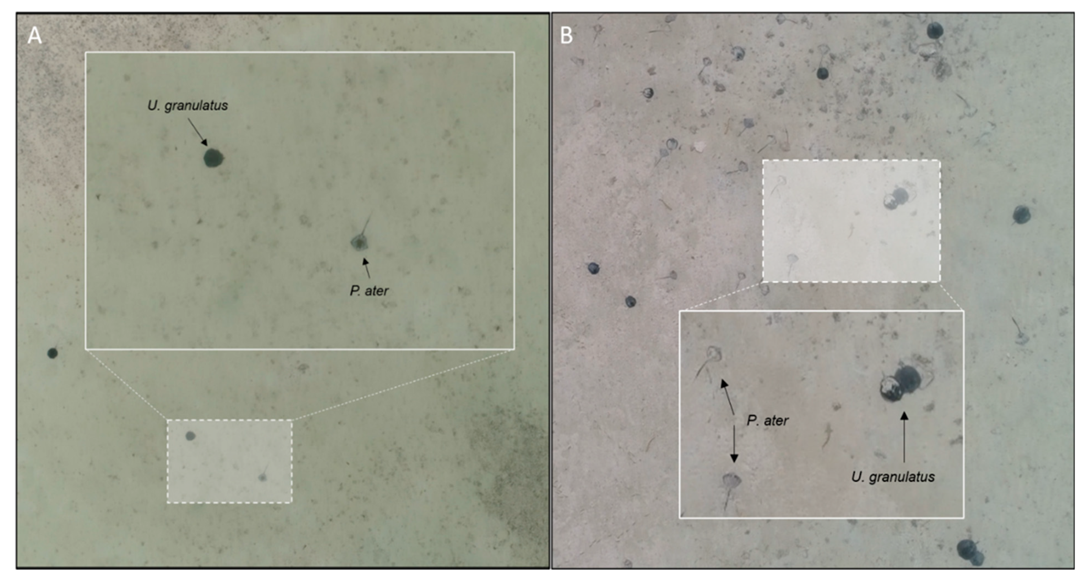
The two study species were readily distinguished from one another and highly visible in video analyses due to distinct disc and tail features. Pastinachus ater has a broad, rhombic disc and is light brown in colour with a well-developed ventral tail fold. Urogymnus granulatus has an oval disc and is dark brown to dark grey in colour with a white, whip-like tail [4]. These features meant that even when buried in the sand, individuals could be identified to species level (Figure 2). Neither species digs deep feeding pits, only covering their body in a thin layer of sand, and in both species, their tails remained exposed and apparent even when buried (corroborated by on-the-ground observations). A third dasyatid ray species (Urogymnus asperrimus) also inhabits the site year-round, and though this species is also highly distinct, due to its pale colouration, it is near impossible to see when buried in sand and so was not included in the study. This species is also easily discerned from the two study species, characterized by a near-circular, sandy coloured disc and a thin tail without any folds. The dorsal side of its disc is also covered in thorns. This meant that, when visible, this species could be easily distinguished from study species. Video analysis was conducted by experienced observers (RB, DF) in either Quicktime player (Apple Inc. Cupertino, CA, USA) or Adobe Premier Pro (Adobe Inc. San Jose, CA, USA) and counts of individuals of each species were noted for each flight. A 4K ultra-HD monitor and high-performance computer were used for analysis. For each individual count, information on the substrate upon which the ray was recorded as well as the transect section were noted. Substrate type was classified as either sand or seagrass and based on the majority substrate immediately below an individual (>50% sand or >50% seagrass). Transect sections for all counts were classified by the time of record (entry of individual onto the screen). Given that flights took 3 min to cover the 1 km transect length, counts were grouped into transect sections by the first, second and third min of the flight. Videos were played back at 0.5× speed and frequently paused when counting. Only certain identifications were included in counts and analysis. Adult rays of both species are known to use the site intermittently, but no adults were recorded in any transect (disk width >80 cm, calculated using Tracker image analysis software v.6.0 and based on size at maturity estimates for both species).

2.4. Data Analysis

A Spearman’s rank correlation was generated in R Studio [36] to test for associations in counts of P. ater and U. granulatus across all survey flights. Multivariate analyses were used to model the influence of distance to the shoreline on the abundance of rays. Distance to the nearest point of shore was measured at the start, centre and end points of each transect (using a near table function in ArcGIS), and a mean of these measurements taken as the distance-to-shore of that transect. Transects were then grouped into three categories; 0–250 m, 251–500 m and 500+ m, based on their distance-to-shore value. The influence of tidal height was also modelled to assess whether water depth affected visibility and thereby count estimates. A permutational multivariate analysis of variance (PERMANOVA) was generated in PRIMER v7 [37] with the PERMANOVA+ add on [38]. Tests with 9999 permutations were based on a Bray–Curtis similarity matrix constructed from square-root transformed abundance data. Mean counts for each species in each transect section were calculated, and abundance plots were generated in ArcMap v.10.6.1 using the start, centre and end points of each transect.
Mean population densities in sand and seagrass substrates were calculated for each transect using mean counts, divided by the total area of each transect (0.04 km2) and presented as rays per km2 (as in [27]). Procedures for estimating absolute population abundance ( N ^ ) were based on extrapolation of count-derived density estimates to the total habitat area [39,40,41]. Extrapolating to obtain estimates of abundance requires the division of the count (n) by the survey area (a), generating an estimate of animal density (as noted above). This is then multiplied by the size of the study area (A). The statistical model for this can be presented as N ^ = n a × A. This assumes, however, that densities of animals in survey counts are representative of the broader habitat, and this is rarely the case [40]. To account for habitat and density heterogeneity and inform more precise estimates of absolute abundance for each species, the total habitat area (the flats of St Joseph Atoll) was delineated by substrate type and proximity to the shoreline (using the same categories as above) into sub-habitat areas. Polygons were created for these sub-habitat zones in ArcGIS, producing area values for both sand and seagrass habitat at 0–250 m, 251–500 m and 500+ m from the shoreline of all islands. Abundance estimates were then calculated through direct extrapolation of mean population densities to the appropriate sub-habitat area. Per-habitat abundance estimates were then summed to produce absolute population abundance estimates ( N ^ ) for each species. These were presented with 95% Poisson confidence intervals (95% CI) and coefficient of variation percentage values ( C V N ^ = s N ^ N ^ ×100).

3. Results

Between 5 March and 22 April 2023, 80 automated drone survey flights were conducted across the 20 transect sites, summing to a total surveyed distance of 80 km and an area covered of 3.2 km2. A total of 1262 P. ater and 822 U. granulatus were observed throughout the survey equating to a mean of 15.65 (±4.4 SE) P. ater and 10.28 (±2.4 SE) U. granulatus individuals per survey flight.

3.1. Patterns in Abundance

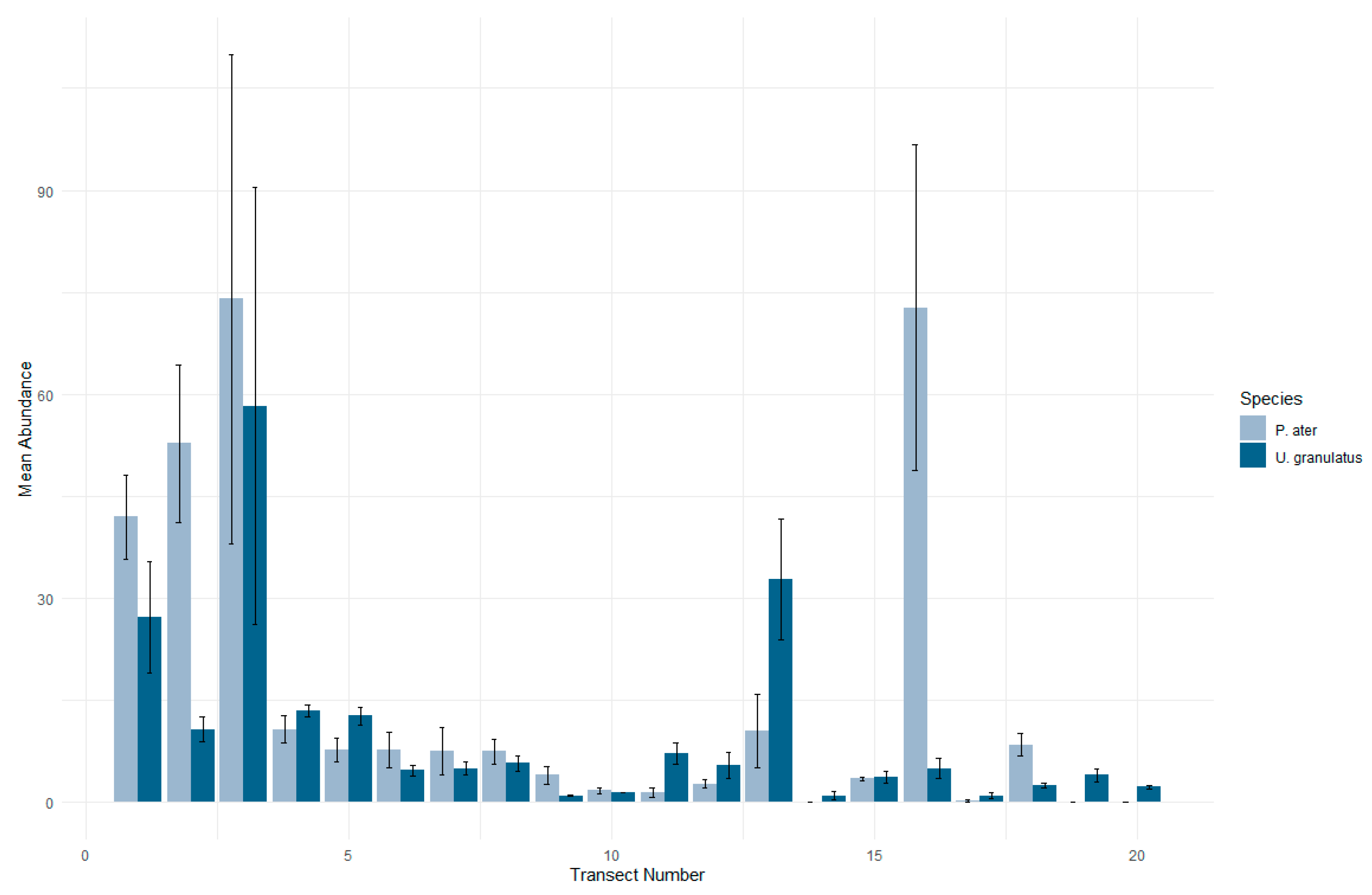
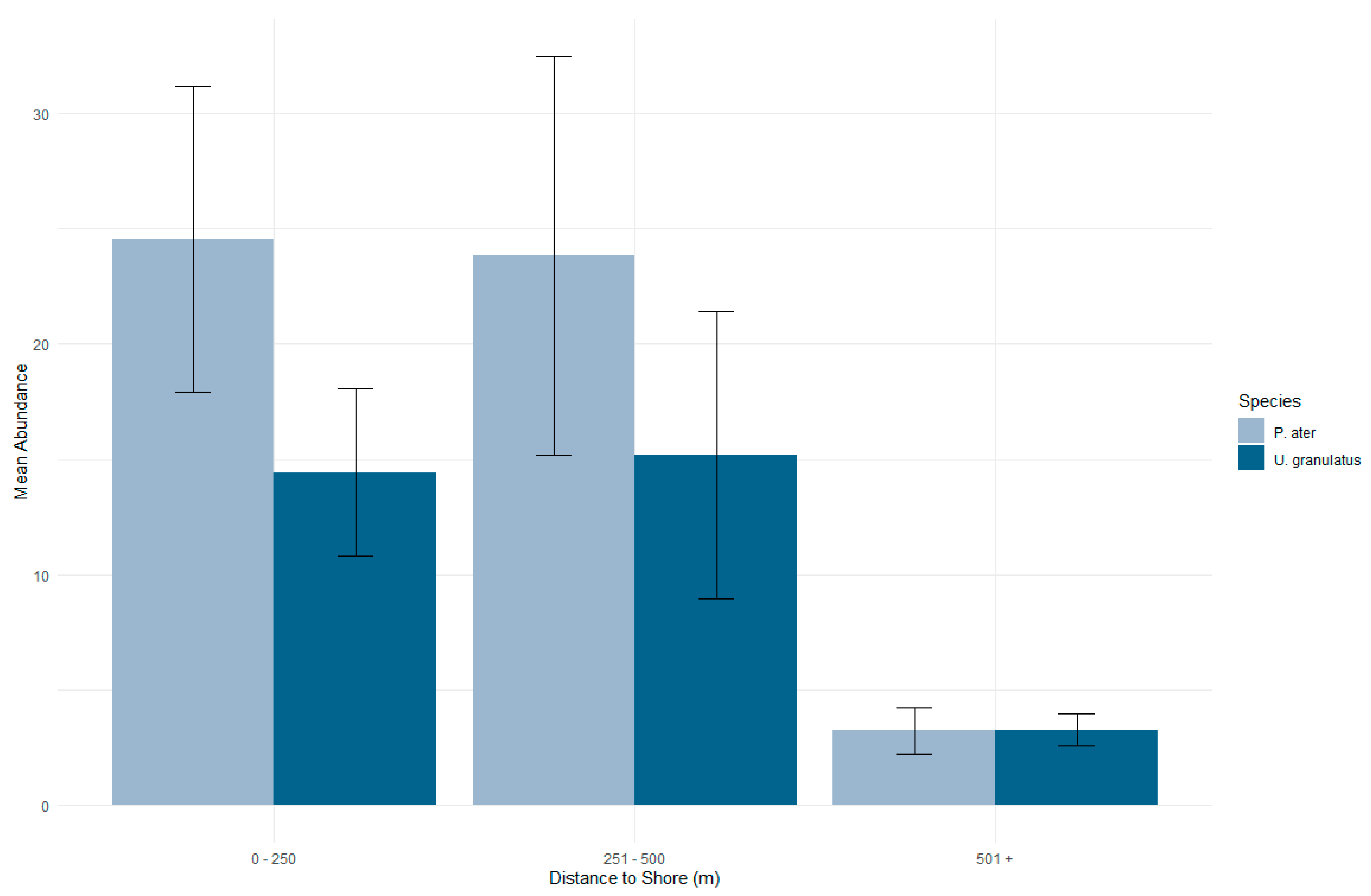
Survey data showed that both species almost exclusively used areas of sand substrate as opposed to seagrass. A total of 99.2% of all P. ater and 93.9% of all U. granulatus counts were made over sand substrate. Counts of each species across all survey flights were highly associated (Spearman’s rank correlation: rs = 0.7 p = < 0.001), and differences in counts between survey transects were similar for both species (Figure 3). Mean distance to the shoreline of survey transects also correlated significantly with ray abundance (PERMANOVA: Pseudo F = 2.79, p = 0.03). Both species occurred in greater abundances in areas closer to the shoreline, and abundance was markedly reduced in areas further than 500 m from shore (Figure 4). No significant effect of tidal height was found, indicating no effect of water depth on visibility and count estimation. No observable evidence of disturbance from the drone was noted with no changes to swimming behaviour or sinuosity in any swimming rays recorded. The majority of rays were stationary during recording and remained so as the drone passed overhead.

3.2. Distribution in the Habitat

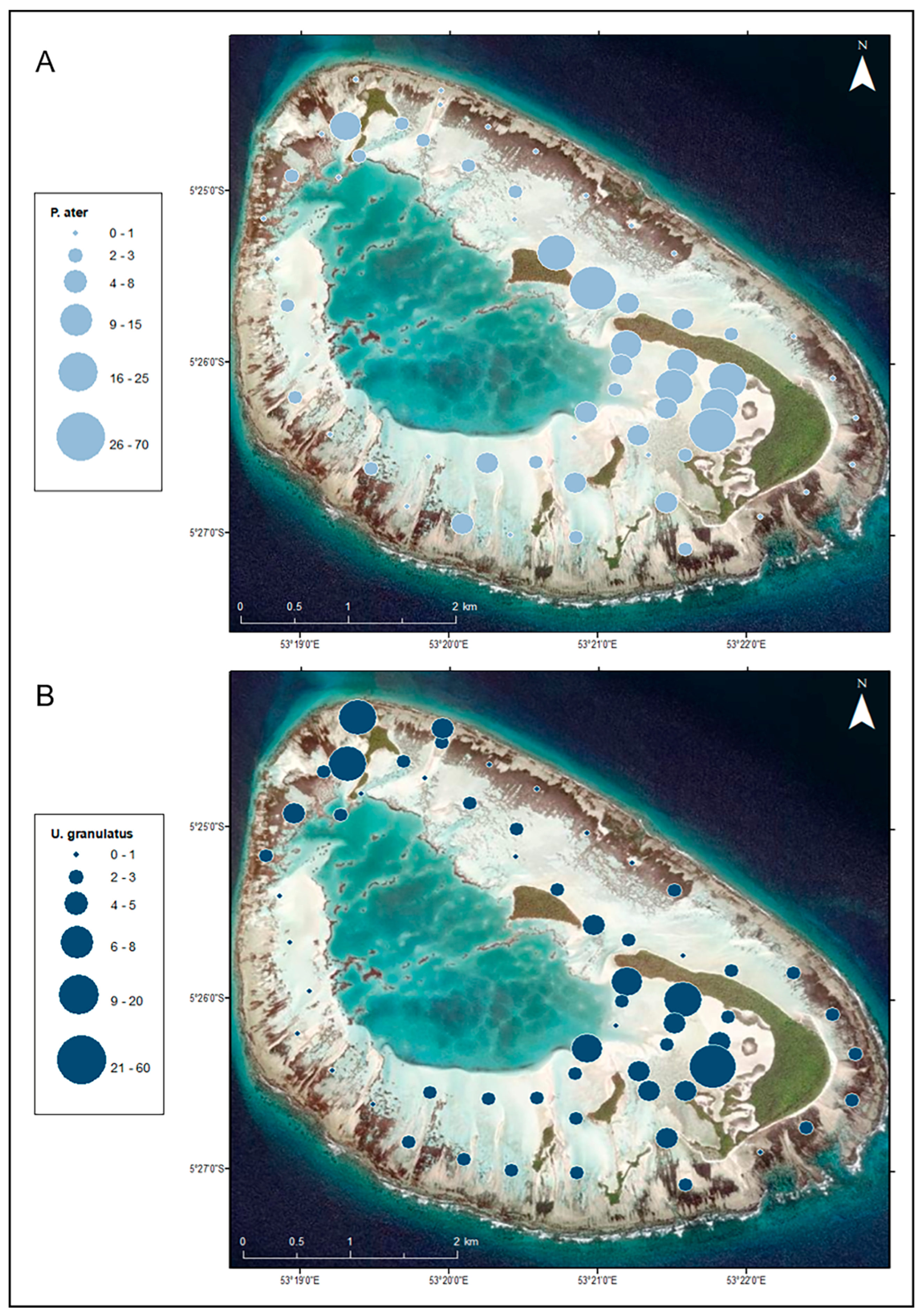
Distribution mapping highlighted high-use areas for P. ater and U. granulatus. Both species were found in the greatest numbers on the flats of the inner atoll, particularly to the east of the lagoon, along the inner shore of the main island of the atoll and nearshore of the northern atoll islands (Figure 5A,B). Pastinachus ater occupied open flats to the west of the atoll that were unused by U. granulatus, and conversely, U. granulatus used areas towards the outer edges of the atoll to the east that were not used by P. ater. Additionally, markedly greater abundances of P. ater were recorded in Transect 2 and Transect 16.

3.3. Population Density and Abundance

Estimated population densities for P. ater were 235.6 rays per km2 in the sand habitat and only 2.4 individuals per km2 in seagrass. For U. granulatus, 192.7 individuals per km2 was estimated for sand and 13.7 individuals per km2 for the seagrass habitat (Table S1). Extrapolated to the available habitat, absolute population abundance estimates across the entirety of St Joseph Atoll flats were 2524 (2029–3019 95% CI, 0.1 CV) for P. ater and 2136 (1732–2539 95% CI, 0.09 CV) for U. granulatus (Table S2).

4. Discussion

In this study, drones were shown to be a highly effective tool in delineating the distribution and abundance of rays in shallow water habitats, gathering high resolution data in a rapid, low-cost and non-invasive manner. Findings highlight high-use areas and produce absolute abundance estimates for juvenile populations of P. ater and U. granulatus. These data form a baseline from which it should be possible to monitor the populations of these species over time at St. Joseph Atoll and through the evolution of its MPA.
Findings relating to the habitat use and distribution of these species likely relate to feeding and predator avoidance strategies. Both species were found to almost exclusively use sandy areas over the reef flats, as opposed to seagrass areas, and occurred in greater abundances closer to the shoreline. The preferential use of sand over seagrass makes sense given that most batoid rays feed on in- and meiofauna within soft sediments and that the feeding strategies used by rays to access these resources require the excavation of these sediments [10,42,43]. The previously described diets for both species in the St. Joseph Atoll showed that the majority of prey species occurred in the benthos associated with sandy reef-flat habitats [35]. Additionally, many ray species bury themselves in sand to hide from predators [4], something they cannot do in seagrass areas. Predator avoidance is likely also a driver of the high observed abundances in nearshore areas. At St. Joseph, the shallow reef flats are largely inaccessible to larger sharks [16,44], and juvenile rays likely use the flats to avoid these predators [20]. Elsewhere, towed float GPS telemetry has shown similarly that U. granulatus had a strong affinity for sand flats and nearshore areas, suggesting that these areas provide abundant food resources and protection from predators [45]. The use of communal nurseries in rays has also been shown to reduce predation risk [46]. Here, both species occurred across the site in large mixed-species groups. The degree of space sharing between two species can often be related to the extent to which those species compete for or partition resources [47]. Previous studies into the diets of juveniles of these two species at the St. Joseph site showed distinct dietary niche differentiation [35]. Pastinachus ater were found to feed mainly on bivalve molluscs, and U. granulatus consumed mostly decapod crustaceans. Similarly, previous research into the trophic ecology of these two species sharing a nursery site in Australia showed that these rays also shared sand and reef-flat areas with stable isotope analyses indicating niche differentiation [48]. In the absence of any meaningful resource competition, larger multispecies aggregations may improve individual predator protection [49].
This study highlighted key high-use areas for both species across the atoll flats habitat that were hitherto unresolved. Previous research has shown that juveniles of both species remain almost exclusively on the reef flats, avoiding the coral reef and lagoon habitats of the atoll [20]. These findings add to those already reported [17,20] by identifying specific areas of use by large numbers of rays, particularly in very shallow (<50 cm) and intertidal areas of the habitat that are beyond the reach of acoustic unit deployment and detection ranges. For both species, the shallow and sandy areas along the lagoon facing shores of St. Joseph Island (the largest island of the atoll) were areas of the highest recorded abundance, which was not reflected by acoustic telemetry detections in previous studies [17]. This highlights how drone surveys can be used to overcome the limitations of other methods and more precisely resolve species distributions in especially shallow, clear-water habitats. Telemetry revealed seasonal changes in habitat use of both species at the site [17], and future research could implement longer-term repeated drone surveys to monitor distribution shifts of species over longer-term scales. Despite the noted advantages of drones, acoustic telemetry has great benefits in providing longer-term data and is naturally superior in mapping habitat use in deeper-water areas where drone detection is prohibited. In combination, both acoustic telemetry and drone survey may therefore offer the most intuitive approach to best resolve the habitat use and distribution of rays in well-defined, shallow habitats.
Deriving abundance estimates from density data is a key aspect of conservation science [8]; however, very few studies, to date, have utilised drones to assess densities and population abundances of rays [28,50,51,52]. To the authors knowledge, this is the first study to use drones to estimate the abundance of juvenile ray populations in a given habitat. Though adult rays are known to use the site intermittently, no adult individuals were observed in video analyses in this study. Large estimates of absolute population abundance were made for both study species, though with so few additional studies to draw comparisons to, and the different life stages considered in those studies, it is difficult to define how the size of these population estimates compare to other areas. Densities of pink whiprays Pateobatis fai at a shallow coral reef site in Moorea have been reported at ~0.7 individuals per hectare [28]. Southern stingrays Dasyatis americana and spotted eagle rays Aetobatus narinari were found in abundances of up to 3.8 individuals per survey in relatively small habitats (<3 km2) in the Bahamas [50], and cownose rays Rhinoptera neglecta were reported at ~100 individuals per km2 in coastal areas in Australia (based on extrapolation from numbers of animals per survey presented by Tagliafico et al. [52]. Though only limited comparisons, these data suggest that the densities and abundances reported here represent particularly large populations of rays, given the size of the study site. An uncommon feature of the St. Joseph Atoll is that it lacks a dominant channel and thus strong currents, which results in an abundance of soft sand sediments and seagrass beds that provide a highly suitable habitat to support large numbers of rays [20]. Further, it has been shown that dietary differentiation also supports the coexistence of abundant populations [35,53,54]. The use of drones for scientific surveys, although advantageous in many ways, does come with its own sources of error that must be considered in the study design. Two major sources of bias in count-based aerial survey are availability and perception biases [29,55]. Availability bias refers to the potential for animals to be unavailable for counting (animals are hidden from view, obstructed or otherwise difficult to detect). By conducting surveys in clear, shallow waters and in calm conditions, as was done here, this error is significantly reduced [28,56,57]. Water depth was also shown here to have no effect on the numbers of animals detected. Further, the high degree of conspicuity of both species, even when buried in the sand, ensured reliable detection and no other objects in the environment were likely to be mistaken as rays. Flight patterns, and aircraft speed were also selected such that the chance of double detections with drones was small [29]. No transect was flown more than once in a day and adjacent transects were at least 250 m apart and were only ever surveyed within minutes of one another. Perception bias refers to variation in detecting targeted objects. By recording the video, much of this bias is removed [29,58], and the analysis here was conducted only by experienced individuals. Despite this, it was not possible to collect direct reference data in the field to verify drone-based counts, and this limited the capacity to statistically quantify the error. Several studies have used the placement of mock or replica animals in survey areas to test for perception error, and such trials may be of value in future studies. Various machine learning methods are increasingly being used to analyse population abundance data with the advantage of accounting for sources of imperfect detection. These methods require large datasets for training and to ensure robustness but offer powerful means to produce reliable abundance estimates and should be considered for drone-based estimates of absolute population abundance.
Juvenile survivorship in batoid rays is an important factor in sustaining populations [13,59,60], and effective conservation of batoid nursery areas is therefore critical. MPAs are important tools for conservation, supporting species populations and mitigating biodiversity loss; however, their placement and regulations should be reflective of threats that they can realistically manage [33,61]. Many large MPAs, including that which encompasses the St. Joseph Atoll, allow for various uses rather than a complete prohibition of activities. For areas such as these, it is unrealistic to designate vast swathes of habitat for complete protection. However, precisely targeting discrete areas within broader MPA boundaries for more realistically manageable protection measures is likely to have more successful outcomes. The findings here identify large populations and key high-use areas at the St. Joseph Atoll site for juvenile populations of two threatened dasyatid rays. St. Joseph likely represents an important area in supporting the viability of these ray populations across the broader region and more specific management measures should be considered for this site, as the implementation and adaption of the Amirantes to Fortune Bank sustainable-use zone progresses.

Supplementary Materials

The following supporting information can be downloaded at: https://www.mdpi.com/article/10.3390/drones8020048/s1. Table S1: Summary of mean counts and per-habitat densities for P. ater and U. granulatus recorded from 80 drone flights at 20 survey transects across the St. Joseph Atoll, Seychelles.; Table S2: Summary of per-habitat and absolute abundance estimates for P. ater and U. granulatus from drone survey across the St. Joseph Atoll, Seychelles.

Author Contributions

Conceptualization, R.B.; methodology, R.B., D.F., E.M., D.P. and H.G.; formal analysis, R.B. and D.F.; investigation, R.B., D.F., E.M., D.P. and H.G.; data curation, R.B. and D.F.; writing—original draft preparation, R.B.; writing—review and editing, R.B., D.F., E.M., D.P. and H.G.; project administration, H.G. All authors have read and agreed to the published version of the manuscript.

Funding

This research received no external funding.

Data Availability Statement

The data presented in this study are available on request from the corresponding author. The data are not publicly available due to their continued use for other research projects.

Acknowledgments

The authors gratefully acknowledge the founder of the Save Our Seas Foundation who provided all funds to carry out this study.

Conflicts of Interest

The authors declare no conflicts of interest.

References

  1. Stevens, J.D.; Bonfil, R.; Dulvy, N.K.; Walker, P. The effects of fishing on sharks, rays and chimaeras (Chondrichthyans), and the implications for marine ecosystems. ICES J. Mar. Sci. 2000, 57, 476–494. [Google Scholar] [CrossRef]
  2. White, W.T.; Kyne, P.M. The status of chondrichthyan conservation in the Indo-Australasian region. J. Fish Biol. 2010, 76, 2090–2117. [Google Scholar] [CrossRef] [PubMed]
  3. Chin, A.; Kyne, P.M.; Walker, T.I.; McAuley, R.B. An integrated risk assessment of climate change: Analysing the vulnerability of sharks and rays on Australia’s Great Barrier Reef. Glob. Chang. Biol. 2010, 16, 1936–1953. [Google Scholar] [CrossRef]
  4. Last, P.R.; Naylor, G.J.P.; Seret, B.; White, W.T.; de Carvalho, M.R.; Stehmann, M.F.W. Rays of the World; CSIRO Publishing: Clayton, Australia, 2016. [Google Scholar]
  5. Dulvy, N.K.; Pacoureau, N.; Rigby, C.L.; Pollom, R.A.; Jabado, R.W.; Ebert, D.A.; Finucci, B.; Pollock, C.M.; Cheok, J.; Derrick, D.H.; et al. Overfishing drives over one-third of all shark and rays towards a global extinction crisis. Curr. Biol. 2021, 31, 4773–4787. [Google Scholar] [CrossRef] [PubMed]
  6. Cerutti-Pereya, F.; Thums, M.; Austin, C.M.; Bradshaw, C.J.A.; Stevens, J.D.; Babcock, R.C.; Pillans, R.D.; Meekan, M.G. Restricted movements of juvenile rays in the lagoon of Ningaloo Reef, Western Australia—Evidence for the existence of a nursery. Environ. Biol. Fishes 2014, 97, 371–383. [Google Scholar] [CrossRef]
  7. Flowers, K.I.; Heithaus, M.R.; Papastamatiou, Y.P. Buried in the sand: Uncovering the ecological roles and importance of rays. Fish Fish. 2021, 22, 105–127. [Google Scholar] [CrossRef]
  8. Wich, S.A.; Hudson, M.; Andrianandasana, H.; Longmore, S.N. Drones for conservation. In Conservation Technology; Wich, S.A., Piel, A.K., Eds.; Oxford University Press: Oxford, UK, 2021. [Google Scholar] [CrossRef]
  9. Martins, A.P.B.; Heupel, M.R.; Chin, A.; Simpfendorfer, C.A. Batoid nurseries: Definition, use and importance. Mar. Ecol. Prog. Ser. 2018, 595, 253–267. [Google Scholar] [CrossRef]
  10. Martins, A.P.B.; Heupel, M.R.; Bierwagen, S.L.; Chin, A.; Simpfendorfer, C.A. Diurnal activity patterns and habitat use of juvenile Pastinachus ater in a coral reef flat environment. PLoS ONE 2020, 15, e0228280. [Google Scholar] [CrossRef]
  11. Oleksyn, S. The Application of Drones in Ray Research. Master’s Thesis, Macquarie University, Sydney, Australia, 2022. [Google Scholar]
  12. Riding, T.A.C.; Dennis, T.E.; Stewart, C.L.; Walker, M.M.; Montgomery, J.C. Tracking fish using ‘buoy-based’ GPS telemetry. Mar. Ecol. Prog. Ser. 2009, 377, 255–262. [Google Scholar] [CrossRef]
  13. Martins, A.P.B. Refining the Ecological Role of Stingrays in Coral Reef Ecosystems. Ph.D. Thesis, James Cook University, Douglas, Australia, 2019. [Google Scholar]
  14. Heupel, M.R.; Simpfendorfer, C.A. Using acoustic monitoring to evaluate MPAs for shark nursery areas: The importance of long-term data. Mar. Technol. Soc. J. 2005, 39, 10–18. [Google Scholar] [CrossRef]
  15. Heupel, M.R.; Ledee, E.J.; Simpfendorfer, C.A. Telemetry reveals spatial separation of co-occurring reef sharks. Mar. Ecol. Prog. Ser. 2018, 589, 179–192. [Google Scholar] [CrossRef]
  16. Lea, J.S.E.; Humphries, N.E.; Bortoluzzi, J.; Daly, R.; von Brandis, R.G.; Patel, E.; Patel, E.; Clarke, C.R.; Sims, D.W. At the turn of the tide: Space use and habitat partitioning in two sympatric shark species is driven by tidal phase. Front. Mar. Sci. 2020, 7, 624. [Google Scholar] [CrossRef]
  17. Elston, C.; Cowley, P.D.; von Brandis, R.G.; Lea, J. Stingray habitat use is dynamically influenced by temperature and tides. Front. Mar. Sci. 2022, 8, 754404. [Google Scholar] [CrossRef]
  18. Heupel, M.R.; Semmens, J.M.; Hobday, A.J. Automated acoustic tracking of aquatic animals: Scales, design and deployment of listening station arrays. Mar. Freshw. Res. 2006, 57, 113. [Google Scholar] [CrossRef]
  19. Davy, L.E.; Simpfendorfer, C.A.; Heupel, M.R. Movement patterns and habitat use of juvenile mangrove whiprays (Himantura granulata). Mar. Freshw. Res. 2015, 66, 481–492. [Google Scholar] [CrossRef]
  20. Elston, C.; Cowley, P.D.; von Brandis, R.G.; Lea, J. Residency and habitat use patterns by sympatric stingrays at a remote atoll in the Western Indian Ocean. Mar. Ecol. Prog. Ser. 2021, 662, 97–114. [Google Scholar] [CrossRef]
  21. Cagua, E.F.; Berumen, M.L.; Tyler, E.H.M. Topography and biological noise determine acoustic detectability on coral reefs. Coral Reefs 2013, 32, 1123–1134. [Google Scholar] [CrossRef]
  22. Royle, J.A. N-mixture models for estimating population size from spatially replicated counts. Biometrics 2004, 60, 108–115. [Google Scholar] [CrossRef] [PubMed]
  23. Skomal, G.; Bernal, D. Physiological responses to stress in sharks. In Biology of Sharks and Their Relatives; Carrier, J.C., Musick, J.A., Heithaus, M.R., Eds.; CRC Press: Boca Raton, FL, USA, 2010; pp. 459–490. [Google Scholar]
  24. Murchie, K.J.; Danylchuk, A.J.; Cooke, S.J.; O’Toole, A.C.; Shultz, A.; Haak, C.; Brooks, E.; Suski, C.D. Considerations for tagging and tracking fish in tropical coastal habitats: Lessons from bonefish, barracuda, and sharks tagged with acoustic transmitters. In Handbook of Fisheries Telemetry; American Fisheries Society Special Publication: Bethesda, MD, USA, 2012. [Google Scholar]
  25. Johnson, D.W. Unoccupied aircraft systems in marine science and conservation. Annu. Rev. Mar. Sci. 2019, 11, 439–463. [Google Scholar] [CrossRef] [PubMed]
  26. Robinson, N.J.; Bigelow, W.F.; Cuffley, J.; Gary, M.; Hoefer, S.; Mills, S.; Smith, A.; Miguel Blanco, A. Validating the use of drones for monitoring the abundance and behaviour of juvenile green sea turtles in mangrove creeks in the Bahamas. Testudo 2020, 9, 24–35. [Google Scholar]
  27. Stokes, H.J.; Mortimer, J.A.; Laloe, J.-O.; Hays, G.C.; Esteban, N. Synergistic use of UAV surveys, satellite tracking data, and mark-recapture to estimate abundance of elusive species. Ecosphere 2023, 14, e4444. [Google Scholar] [CrossRef]
  28. Kiszka, J.J.; Mourier, J.; Gastrich, K.; Heithaus, M.R. Using unmanned aerial vehicles (UAVs) to investigate shark and ray densities in a shallow coral lagoon. Mar. Ecol. Prog. Ser. 2016, 560, 237–242. [Google Scholar] [CrossRef]
  29. Kiszka, J.J.; Heithaus, M.R. Using aerial surveys to investigate the distribution, abundance, and behavior of sharks and rays. In Shark Research: Emerging Technologies and Applications for the Field and Laboratory; Carrier, C., Heithaus, M.R., Simpfendorfer, C.A., Eds.; CRC Press: Boca Raton, FL, USA, 2018; pp. 71–82. [Google Scholar]
  30. Pate, J.H.; Marshall, A.D. Urban manta rays: Ptoential manta ray nursery habitat along a highly developed Florida coastline. Endanger. Species Res. 2020, 43, 51–64. [Google Scholar] [CrossRef]
  31. Desgarnier, L.; Mouillot, D.; Vigliola, L.; Chaumont, M.; Mannocci, L. Putting eagle rays on the map by coupling aerial video-surveys and deep learning. Biol. Conserv. 2022, 267, 109494. [Google Scholar] [CrossRef]
  32. McIvor, A.J.; Spaet, J.L.Y.; Williams, C.T.; Berumen, M.L. Unoccupied aerial video (UAV) surveys as alternatives to BRUV surveys for monitoring elasmobranch species in coastal waters. ICES J. Mar. Sci. 2022, 79, 1604–1613. [Google Scholar] [CrossRef]
  33. Bullock, R.W.; Grimmel, H.M.V.; Moulinie, E.E.; Pouponeau, D.P.; Lea, J.S.E. Using global Red List data to inform localized research and conservation priorities—A case study in the Republic of Seychelles. Diversity 2022, 14, 681. [Google Scholar] [CrossRef]
  34. Weideli, O.C.; Papastamatiou, Y.P.; Planes, S. Size frequency, dispersal distances and variable growth rates of young sharks in a muliti-species aggregation. J. Fish Biol. 2019, 94, 789–797. [Google Scholar] [CrossRef]
  35. Elston, C.; Cowley, P.D.; von Brandis, R.G.; Fisk, A. Dietary niche differentiation in a mesopredatory dasyatid assemblage. Mar. Biol. 2020, 167, 89. [Google Scholar] [CrossRef]
  36. R Core Team. R: A Language and Environment for Statistical Computing; R Foundation for Statistical Computing: Vienna, Austria, 2020; Available online: https://www.R-project.org/ (accessed on 1 October 2023).
  37. Clarke, K.R.; Gorley, R.N. Getting started with PRIMER v7; Plymouth Marine Laboratory: Plymouth, UK, 2015; Volume 20. [Google Scholar]
  38. Anderson, M. PERMANOVA+ for PRIMER: Guide to Software and Statistical Methods. Primer-E Limited; 2008. Available online: https://cir.nii.ac.jp/crid/1370572092711312918 (accessed on 1 October 2023).
  39. Kappes, M.A.; Coustaut, K.; Le Corre, M. Census of wedge-tailed shearwaters Puffinus pacificus breeding at D’Arros Island and St Joseph Atoll, Seychelles. Mar. Ornithol. 2013, 41, 29–34. [Google Scholar]
  40. Hammond, P.S.; Francis, T.B.; Heinemann, D.; Long, K.J.; Moore, J.E.; Punt, A.E.; Reeves, R.R.; Sepulveda, M.; Mar Sigurosson, G.; Siple, M.C.; et al. Estimating the Abundance of Marine Mammal Populations. Front. Mar. Sci. 2021, 8, 735770. [Google Scholar] [CrossRef]
  41. Preston, T.M.; Wildhaber, M.L.; Green, N.S.; Albers, J.L.; Debenedetto, G.P. Enumerating white-tailed deer using unmanned aerial vehicles. Wildl. Soc. Bull. 2021, 45, 97–108. [Google Scholar] [CrossRef]
  42. O’Shea, O.; Thums, M.; van Keulen, M.; Meekan, M.G. Bioturbation by stingrays at Ningaloo reef, Western Australia. Mar. Freshw. Res. 2011, 63, 189. [Google Scholar] [CrossRef]
  43. Takeuchi, S.; Tamaki, A. Assessment of benthic disturbance associated with stingray foraging for ghost shrimp by aerial survey over an intertidal sandflat. Cont. Shelf Res. 2014, 84, 139–157. [Google Scholar] [CrossRef]
  44. Filmalter, J.D.; Dagorn, L.; Cowley, P.D. Spatial behaviour and site fidelity of the sicklefin lemon shark Negaprion acutidens in a remote Indian Ocean atoll. Mar. Biol. 2013, 160, 2425–2436. [Google Scholar] [CrossRef]
  45. Martins, A.P.B.; Heupel, M.R.; Bierwagen, S.L.; Chin, A.; Simpfendorfer, C.A. Tidal-diel patterns of movement, activity and habitat use by juvenile mangrove whiprays using towed-float GPS telemetry. Mar. Freshw. Res. 2020, 72, 534–541. [Google Scholar] [CrossRef]
  46. Simpfendorfer, C.A.; Milward, N.E. Utilisation of a tropical bay as a nursery area by sharks of the families Carcharhinidae and Sphyrnidae. Environ. Biol. Fishes 1993, 37, 337–345. [Google Scholar] [CrossRef]
  47. McPeek, M.A. Limiting factors, competitive exclusion, and a more expansive view of species coexistence. Am. Nat. 2014, 183, 3–5. [Google Scholar] [CrossRef] [PubMed]
  48. Martins, A.P.B.; Matley, J.K.; Heupel, M.R.; Fis, A.T.; Chin, A.; Simpfendorfer, C.A. Trophic ecology of sympatric juvenile stingrays within a nursery area. Mar. Freshw. Res. 2022, 73, 678–688. [Google Scholar] [CrossRef]
  49. Semeniuk, C.A.D.; Dill, L.M. Anti-predator benefits of mixed-species groups of cowtail rays (Pastinachus sephen) and whiprays (Himantura uarnak) at rest. Ethology 2006, 112, 33–43. [Google Scholar] [CrossRef]
  50. Hensel, E.; Wenclawski, S.; Layman, C.A. Using a small, consumer-grade drone to identify and count marine megafauna in shallow habitats. Lat. Am. J. Aquat. Res. 2018, 46, 1025–1033. [Google Scholar] [CrossRef]
  51. Kelaher, B.P.; Colefax, A.P.; Tagliafico, A.; Bishop, M.J.; Giles, A.; Butcher, P.A. Assessing variation in assemblages of large marine fauna off ocean beaches using drones. Mar. Freshw. Res. 2020, 71, 68–77. [Google Scholar] [CrossRef]
  52. Tagliafico, A.; Butcher, P.A.; Colefax, A.P.; Clark, G.F.; Kelaher, B.P. Variation in cownose ray Rhinptera neglecta abundance and group size on the central east coast of Australia. J. Fish Biol. 2020, 96, 427–433. [Google Scholar] [CrossRef]
  53. Bornatowski, H.; Braga, R.R.; Abilhoa, V.; Correa, M.F.M. Feeding ecology and trophic comparisons of six shark species in a coastal ecosystem off southern Brazil. J. Fish Biol. 2014, 85, 246–263. [Google Scholar] [CrossRef]
  54. Pardo, S.A.; Burgess, K.B.; Teixeira, D.; Bennett, M.B. Local-scale resource partitioning by stingrays on an intertidal flat. Mar. Ecol. Prog. Ser. 2015, 533, 205–218. [Google Scholar] [CrossRef]
  55. Brack, I.V.; Kindel, A.; de Oliveira, L.F.B.; Lahoz-Monfort, J.J. Optimally designing drone-based surveys for wildlife abundance estimation with N-mixture models. Methods Ecol. Evol. 2023, 14, 898–910. [Google Scholar] [CrossRef]
  56. Rieaucau, G.; Kiszka, J.J.; Castillo, J.C.; Mourier, J.; Boswell, K.M.; Heithaus, M.R. Using unmanned aerial vehicles (UAV) surveys and image analysis in the study of large surface-associated marine species: A case study on the reef sharks Carcharhinus melanopterus shoaling behaviour. J. Fish Biol. 2018, 93, 119–127. [Google Scholar] [CrossRef]
  57. Colefax, A.P.; Butcher, P.A.; Pagendam, D.E.; Kelaher, B.P. Reliability of marine faunal detections in drone-based monitoring. Ocean. Coast. Manag. 2019, 174, 108–115. [Google Scholar] [CrossRef]
  58. Buckland, S.T.; Burt, M.L.; Rexstad, E.A.; Mellor, M.; Williams, A.E.; Wooward, R. Aerial surveys of seabirds: The advent of digital methods. J. Appl. Ecol. 2012, 49, 960–967. [Google Scholar] [CrossRef]
  59. Frisk, M.G.; Martell, S.J.D.; Miller, T.J.; Sosebee, K. Exploring the population dynamics of winter skate (Leucoraja ocellata) in the Georges Bank region using a statistical catch-at-age model incorporating length, migration, and recruitment process errors. Can. J. Fish. Aquat. Sci. 2010, 67, 774–792. [Google Scholar] [CrossRef]
  60. Goldman, K.J.; Cailliet, G.M.; Andrews, A.H.; Natanson, L.J. Assessing the age and growth of chondrichthyan fishes. In Biology of Sharks and Their Relatives; Carrier, J.C., Musick, J.A., Heithaus, M.R., Eds.; CRC Press: Boca Raton, FL, USA, 2012; pp. 423–451. [Google Scholar]
  61. Kuempel, C.D.; Jones, K.R.; Watson, J.E.M.; Possingham, H.P. Quantifying biases in marine protected area placement relative to abatable threats. Conserv. Biol. 2019, 33, 1350–1359. [Google Scholar] [CrossRef]
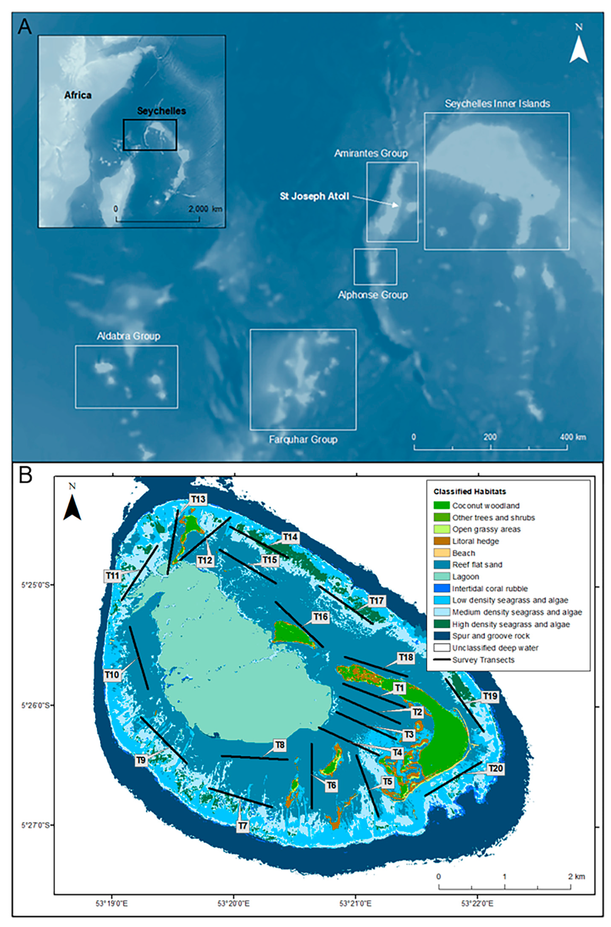
Figure 1. (A) Geographic position of the St. Joseph Atoll in the Amirantes island group with an inset map of the Republic of Seychelles in relation to the wider Western Indian Ocean (created using GEBCO_08 bathymetry data: GEBCO Compilation Group 2020) and (B) the St. Joseph Atoll with classified habitats and drone survey transects displayed. Habitat data created by n + p biologists (www.nplusp.ch, accessed on 1 October 2023) using supervised image classification of 2 m 8 band MS 16-bit orthorectified WorldView-2 high-resolution satellite images from LAND INFO Worldwide Mapping, LLC., (Denver, CO, USA) and is Copyright of Save Our Seas Foundation.
Drones 08 00048 g001
Figure 2. Example still images from drone video survey flown at 30 m (A,B), with a zoomed section (white box—solid line) highlighting the light brown colour and diamond shape of P. ater versus the darker body colour and round disc of U. granulatus.
Drones 08 00048 g002
Figure 3. Mean counts (error bars: ± SD) of P. ater and U. granulatus across all 20 survey transects.
Drones 08 00048 g003
Figure 4. Differences in mean counts (error bars: ± SD) of P. ater and U. granulatus between different distance—to—shoreline categories.
Drones 08 00048 g004
Figure 5. Plots displaying the distribution of mean abundances for (A) P. ater and (B) U. granulatus across the shallow, reef-flat habitats of the St. Joseph Atoll site. Plot points taken from GPS coordinates at the start, centre and end points of all 20 survey transects. Map base layer source: Esri ® (Esri, Redlands, CA, USA).
Drones 08 00048 g005
Disclaimer/Publisher’s Note: The statements, opinions and data contained in all publications are solely those of the individual author(s) and contributor(s) and not of MDPI and/or the editor(s). MDPI and/or the editor(s) disclaim responsibility for any injury to people or property resulting from any ideas, methods, instructions or products referred to in the content.