Article

Urban Forest Above-Ground Biomass Estimation Based on UAV 3D Real Scene

1
State Key Laboratory of Subtropical Silviculture, Zhejiang A & F University, Hangzhou 311300, China
2
Key Laboratory of Carbon Cycling in Forest Ecosystems and Carbon Sequestration of Zhejiang Province, Zhejiang A & F University, Hangzhou 311300, China
3
School of Environmental and Resources Science, Zhejiang A & F University, Hangzhou 311300, China
4
Research Center of Forest Management Engineering of State Forestry and Grassland Administration, Beijing Forestry University, Beijing 100083, China
*
Author to whom correspondence should be addressed.
Drones 2023, 7(7), 455; https://doi.org/10.3390/drones7070455
Submission received: 6 June 2023 / Revised: 25 June 2023 / Accepted: 5 July 2023 / Published: 8 July 2023
(This article belongs to the Section Drones in Agriculture and Forestry)

Abstract

:
(1) Background: A three-dimensional (3D) real scene is a digital representation of the multidimensional dynamic real-world structure that enables the realistic and stereoscopic expression of actual scenarios, and is an important technological tool for urban refinement management. The above-ground biomass (AGB) of urban forests is an important indicator that reflects the urban ecological environment; therefore, the accurate estimation of AGB is of great significance for evaluating urban ecological functions. (2) Methods: In this study, multiangle aerial photographs of urban street trees were obtained via an unmanned aerial vehicle (UAV) single-lens five-way flight, from 0°, 0°, 90°, 180°, 270°, and five other directions. The multiple view stereo (MVS) algorithm was used to construct three-dimensional realistic models of two tree species: ginkgo and camphor. Then, structural parameters such as tree height, crown diameter, and crown volume were estimated from the 3D real-scene models. Lastly, single-tree AGB models were developed based on structural parameters. (3) Results: The results of this study indicated the following: (A) The UAV visible-light realistic 3D model had clear texture and truly reflected the structural characteristics of two tree species, ginkgo and camphor. (B) There was a significant correlation between the reference tree height, crown diameter and crown volume obtained from the realistic 3D model and the measured values; the R2 for ginkgo height was 0.90, the R2 for camphor crown diameter was 0.87, and the R2 for ginkgo crown volume was 0.89. (C) The accuracy of the AGB estimation models constructed with tree height and canopy volume as variables was generally higher than that of models with tree height and canopy diameter; the model with the highest accuracy of AGB estimation for ginkgo was the linear model with a validation accuracy R2 of 0.96 and RMSE of 8.21 kg, while the model with the highest accuracy of AGB estimation for camphor was the quadratic polynomial model with a validation accuracy R2 of 0.92 and RMSE of 27.74 kg. (4) Conclusions: This study demonstrated that the UAV 3D real-scene model can achieve high accuracy in estimating single-wood biomass in urban forests. In addition, for both tree species, there was no significant difference between the AGB estimates based on the UAV 3D real scene and LiDAR and the measured AGB. These results of urban single-wood AGB estimation based on the UAV 3D real-scene model were consistent with those of LiDAR and even with the measured AGB. Therefore, based on the UAV 3D real-scene model, the single-wood biomass can be estimated with high accuracy. This represents a new technical approach to urban forest resource monitoring and ecological environment function evaluation.

1. Introduction

A three-dimensional (3D) real scene is a digital description and expression of the structure and appearance of the multidimensional dynamic real world with three basic characteristics: three-dimensional, realistic and physical [1,2,3]. Realistic 3D presents actual scenes by virtual means, improves the efficiency of resource use, and helps to improve productivity with high quality. It has been widely used in mapping, water conservation, natural resources’ management, construction, transportation, and electricity [4,5,6,7,8,9,10,11]. For example, high-precision 3D building model scenes were generated from mobile laser scanning (MLS) point clouds and 3D meshes using multisource data fusion [12] and road spatial reorganization and landscape construction by quantifying highway 3D spatial features [13]. The application of 3D real scenes in forestry is still in the exploration stage, and single-wood 3D real scene construction can intuitively obtain parameters such as tree height, crown height, and crown diameter. It can provide advanced technical support for rapid single-wood construction of anisotropic growth models and an accurate estimation of the above-ground biomass (AGB) of forest trees.
Traditional measures of AGB of single wood are mostly obtained through manual ground surveys for parameters such as tree height and diameter and are estimated using growth models [14]. This method is accurate but large-scale ground surveys are time-consuming and laborious and it is difficult to obtain three-dimensional structural information on a forest’s structure [15]. Remote sensing technology has the advantages of fast information acquisition and the ability to observe large areas dynamically and in real time. It has become an important technical tool for forest parameters and AGB estimation [16,17,18]. However, urban forests consist of scattered trees, forest strips, and patch forests [19] with diverse structures and fragmented distributions. Thus, obtaining the three-dimensional structure of urban forests, such as single-tree height and diameter at breast height, from satellite remote sensing data is difficult [20].
Unmanned aerial vehicles (UAV) have the advantages of low cost, flexible take-off and landing, safety, ability to fly under clouds, and high image resolution [21,22,23]; they are a new technological means for forest resource monitoring. In recent years, LiDAR sensors mounted on UAVs have become popular in domestic and international research for acquiring 3D forest structures and AGB estimation [19,24,25,26,27,28,29]. For example, scholars have accurately extracted single-wood structure information of mangrove forests using laser lightning technology to achieve a high-precision estimation of parameters such as mangrove forest height, crown width and AGB [30,31]. Reda Fekry et al. fused UAV-LiDAR and ground-based radar data to achieve the quantitative structural modeling and tree parameter inversion of subtropical plantation forests [32]. Zhang et al. estimated urban forest biomass using three models based on unmanned aerial vehicle LiDAR (UAV-LiDAR) with two schemes for extracting canopy point cloud height and density feature variables and combining canopy structure variables, obtaining a maximum AGB R2 of 0.85 [29]. Zhou et al. estimated three-dimensional urban forest green matter using LiDAR [19]. Liu et al. obtained forest structure parameters for southern human-made forests based from UAV-LiDAR samples and multispectral satellite images [33].
UAV-LiDAR forest 3D information representation technology has gradually matured, and UAVs carrying visible-light cameras are becoming increasingly common for forest resource monitoring. For example, the revised local maximum (RLM) algorithm obtained using the improved algorithm local maximum (LM) by Xu et al. was used to search for local maxima on transverse tangents in the row and column directions of images to find crown seeds in order to detect canopy centers [34]. Lin et al. used structure of motion (SfM) photogrammetry to extract single-wood height and canopy radius from overlapping images and then used tree height and crown diameter to construct anisotropic growth equations. The AGB was estimated using the tree height and crown diameter to construct anisotropic growth equations [33]. All of these methods can be used to obtain good estimates; however, visible-light cameras essentially acquire two-dimensional information, making it difficult to directly calculate parameters such as canopy position, tree height, and diameter at breast height when the tree canopy is obscured, thus affecting the extension of these aspects. LiDAR point cloud data elevate our understanding of spatial patterns from the traditional two-dimensional distribution model to a three-dimensional thematic space [33], providing a new perspective on the depth of forest resource information mining. The use of multiangle tilt photography via UAV visible cameras to obtain multi-viewpoint stereoscopic point cloud data for building a realistic 3D model of forest trees and applying it to the estimation of forest structure parameters is a popular topic of research.
Creating urban forests is an important component of building a low-carbon, green and sustainable city. The rapid monitoring of tree height, diameter at breast height and other forest growth factors to estimate urban forest biomass is the most direct means of evaluating the ecological function of urban forests. In this study, we construct a 3D real-scene model of urban forests by using the multiple view stereo (MVS) algorithm based on multiangle aerial photographs of urban street trees obtained using a UAV visible-light camera. We obtained structural parameters such as tree height, crown diameter and crown volume from a single-wood 3D model and compare them with the results extracted based on LiDAR point cloud data. This approach provides a new technical means for the rapid and accurate estimation of urban forest AGB and ecological environment function evaluation based on UAV 3D real scenes.

2. Materials and Methods

2.1. Study Area

As shown in Figure 1, the study area is in the East Lake Campus of Zhejiang Agriculture and Forestry University, Lin’an District, Hangzhou City, Zhejiang Province, China (30°15′18.97″ to 30°15′43.90″ N and 119°43′36.27″ to 119°44′28.79″ E). The study area belongs to the subtropical monsoonal humid climate zone, with an average annual temperature of 17.8 °C and an annual precipitation of 1454 mm; rain and heat tend to co-occur, with high temperatures and rain in the summer, a warm and humid climate in the winter, and a suitable climate in the spring and autumn [19]. Ginkgo biloba (ginkgo) and Cinnamomum Camphora (Linn) Presl (camphor) are typical vegetation types in this area, and street trees are mostly dominated by these two species. Therefore, in this study, ginkgo and camphor were used as examples to conduct relevant research.

2.2. Data Acquisition

2.2.1. UAV Data

UAV visible-light data acquisition occurred in October 2022. The DJI Phantom 4 Pro V2.0 quadcopter UAV was used as the remote sensing platform equipped with a DJI FC6310 digital camera for data acquisition under clear weather and a low wind speed. To meet the accuracy requirements of SfM photogrammetry in the later stage [33], the aerial photography was set with a heading overlap of 80%, a side overlap of 70%, a flight height of 60 m, and a flight speed of 8 m/s considering the terrain factors and accuracy requirements. The UAV tilt photography used a single-lens five-way flight, from 0°, 0°, 90°, 180°, 270° and five other directions to obtain data with gimbal angles of −90° and −45°. A total of 2301 photos were acquired, with an image resolution of 5472 × 3648 pixels.
In this study, we also used a DJI Matrice 600 Pro hexacopter UAV with a Velodyne Puck LITETM lightweight laser scanner for UAV-LiDAR data acquisition in the same test area. An estimation of the biomass and a comparison with real-world 3D results were carried out. The flight altitude was 60 m, the flight speed was 8 m/s, the route interval was 25 m, the parallactic overlap was 50%, the scanning frequency was 20 Hz, and the laser emission frequency was 300 kHz. The point cloud average density was 230 points/m2.

2.2.2. Field Measurements

After aerial photography using a UAV, 70 single ginkgo trees and 70 camphor trees within the marked range of Figure 1b were surveyed on the ground, and the diameter, tree height, subbranch height, crown height, crown diameter and crown volume and single-plant biomass were obtained. The diameter was measured at 1.3 m using a diameter measuring tape; the single-plant height and under-branch height were measured using a quasi-continuous variable distance height measuring device; the crown height was calculated as the tree height minus the under-branch height; the crown diameter was obtained by determining the average crown width in the east-west and north-south directions; and the crown volume was calculated based on the crown diameter and crown height. The measurement results of single-standing trees of both species are summarized in Table 1. The AGB of single trees was calculated using the anisotropic growth equation biomass shown in Table 2.

2.3. Study Methods

2.3.1. UAV Visible-Light 3D Real-Scene Model Construction Method

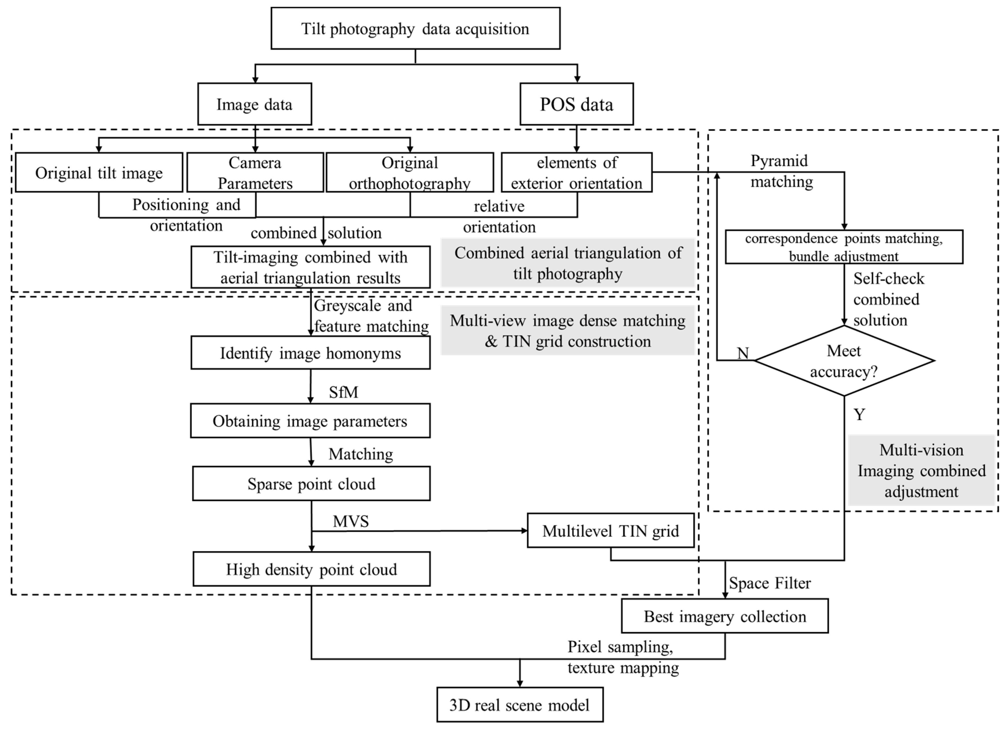
The technical route for the construction of the UAV visible-light 3D real-scene models of the two tree species in this study is shown in Figure 2, including the following steps:
Tilt photography acquires both vertical and tilt view images, while the traditional eponymous point automatic extraction algorithm is only applicable to vertical images. Therefore, the tilt image joint aerial triangulation is needed before the UAV visible-light 3D real-scene model. Due to the small measurement area and flat terrain in this experiment, no ground control points were deployed. Therefore, the POS value of the initial shooting instant is provided by the UAV GPS-IMU, which is combined with the imaging model of the sensor. The POS value is used as a rough initial outer orientation element to calculate the object-square coordinates for relative orientation. From there, the tilt image triangulation results are obtained after the solution.
Next, dense matching of multi-view images is performed. In dense matching, the homonymous image points among images are determined according to grayscale matching, relationship matching and feature matching; the camera parameters of each image are estimated using the SfM algorithm. These parameters are used to generate sparse point clouds, and the sparse point clouds are then densified to obtain high-density point clouds based on the multi-view stereo (MVS) algorithm [37]. Thus, triangulated irregular network (TIN) models and feature 3D information are obtained at different levels of detail.
The joint leveling is based on the POS data acquired using the GPS/IMU system as the outer orientation element of the multi-view image, and the coarse-to-fine pyramidal matching method is used to extract the homonymous points to achieve an automatic matching of homonymous points and beam network leveling at all levels of the image [38]. The joint solution of error equations of the self-checking area network leveling of multi-view images ensures the accuracy of the results [29,39,40].
Lastly, the TIN model is based on the combination of digital 3D technology and spatial geometry technology to spatially filter each image’s data to find the image set that best fits the model, perform image pixel sampling and read into the model, automatically complete texture mapping, and map the texture to the high-density point cloud model to obtain the final study area’s realistic 3D model [41].

2.3.2. Single-Wood Parameter Extraction Method

Single-wood segmentation is the basis for extracting single-wood parameters from a 3D real scene and UAV-LiDAR model. Based on the constructed 3D real-scene model and the acquired UAV-LiDAR point cloud, we generated a digital elevation model (DEM) with a spatial resolution of 0.5 m, digital surface model (DSM) and canopy height model (CHM) [42] via inverse distance weighted interpolation (IDW) [43]; then, the CHM data were used to obtain tree boundaries using a watershed segmentation algorithm, thus realizing single-wood segmentation in the 3D real-scene model mode [44].
Based on single-wood segmentation, the local maximum of the Z coordinate in 3D coordinates was the single-wood height. The crown diameter of a single wood was extracted by selecting the maximum and minimum values of the X and Y coordinates, respectively, in the local area, and the average value of the difference between one half of the X and Y coordinates was the crown diameter.
The canopy volume was extracted using the method of 3D convex wrapping. The 3D convex envelope was used to find the smallest set of points so that the 3D shape composed of these points contained all points in space. In this study, the point cloud of the single-wood canopy was projected onto the 2D plane, and the 2D convex envelope was calculated first. Then, the projected area of the single-wood canopy was extracted based on the convex envelope function [19,23].

2.3.3. Single-Wood AGB Estimation Method

As shown in Table 3, common models for estimating the AGB of single wood include binary linear models, power function models, logarithmic models, and quadratic polynomial models, among other types [33,45,46]. Therefore, in this study, the tree height, crown diameter and crown volume obtained from the live-view 3D model were considered independent variables, and the measured single-wood AGB was used as the dependent variable to construct the prediction models shown in Table 3. The model with the highest accuracy was selected as the final model.
The 3D real scene and UAV-LiDAR can be used to obtain 3D structural parameters such as crown diameter and crown volume, while the traditional biomass anisotropic growth equation parameters are mainly two-dimensional parameters, such as diameter at breast height and tree height. To assess the influence of crown diameter and crown volume on the accuracy of AGB estimation, as shown in Table 3, we built two types of AGB prediction models: those with tree height and crown diameter as variables, and those with tree height and crown volume as variables.

2.3.4. Evaluation of the Accuracy of AGB Estimation

To verify the accuracy of AGB estimation based on 3D realistic single wood, 40 trees were randomly selected for model construction from 70 ginkgo and 70 camphor trees, while the remaining 30 were used for model accuracy evaluation in this study. As shown in Equations (1) and (2), two indicators, the coefficient of determination (R2) and root mean squared error (RMSE), were used in this study to evaluate the accuracy of AGB estimation. Generally, the larger the values of R2 and the smaller the RMSE, the higher the model prediction accuracy.
R 2 = 1 i = 1 n ( x i x i ^ ) 2 i = 1 n ( x i x ¯ i ) 2
R M S E = 1 n i = 1 n ( x i x ^ i ) 2
where x i represents the observed AGB for the ith tree, x ^ i represents the predicted AGB for the ith tree, and n is the number of trees.

3. Results

3.1. 3D Real-Scene Model Construction Results

Based on the technical route of Figure 2, the constructed 3D real scene of the study area is shown in Figure 3a. The self-calibration accuracy of the joint parity of multi-view images constructed using the 3D real-scene model was suppressed by several iterations, and the mis-matching rate of the image point of the same name was less than 5% so that the realistic scenes of ginkgo and camphor could be characterized. Figure 3b–f shows the frontal view and five directions of the ginkgo single tree of the 3D real-scene model, respectively. The texture of the model was clear, and the resolution of the model reached 0.05 m. Figure 3g shows the point cloud structure of one of the segmented single trees. The structure of the single tree shown was similar to that of the real single tree, indicating that the high-density point cloud obtained using the MVS algorithm can meet the requirements of single-tree segmentation and parameter extraction.

3.2. Single-Wood Parameter Extraction Results

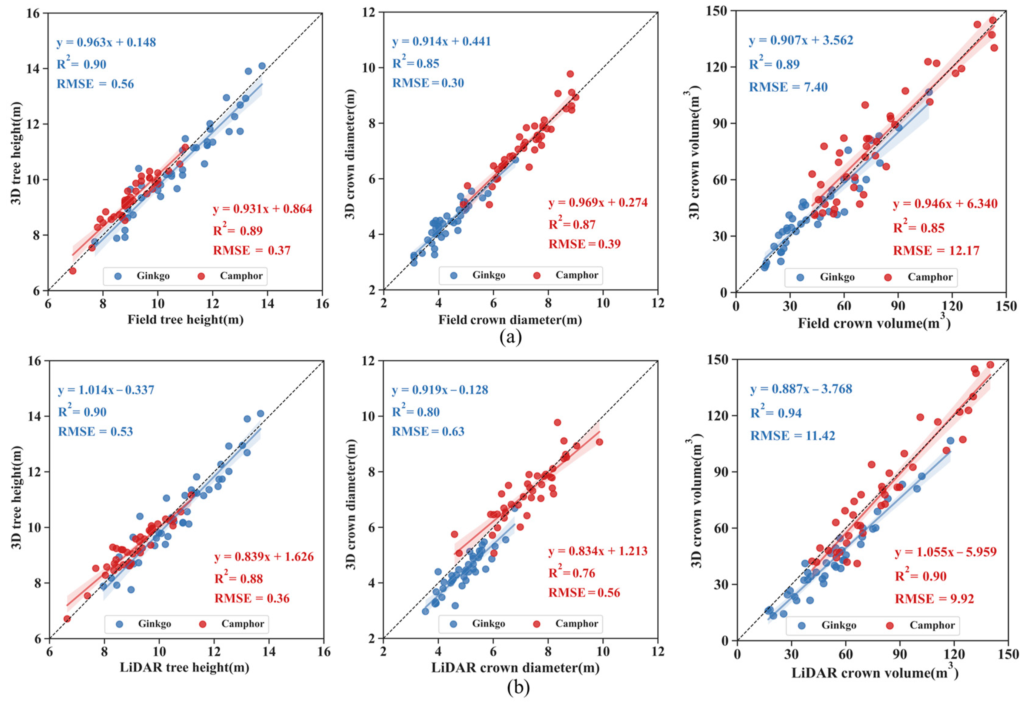
Figure 4a shows the correlation between the three parameters extracted from the 3D real-scene model and the measured parameters, such as tree height, crown diameter and crown volume of ginkgo and camphor. As seen in Figure 4a, there was a significant correlation between the parameters extracted from the 3D real-scene model and the measured parameters: the R2 of ginkgo tree height reached 0.90; the R2 of the camphor crown diameter was 0.87, and the RMSE was 0.39 m; the R2 of the ginkgo canopy volume was 0.89, and the RMSE was only 7.4 m3. Domestic and international research indicates that UAV-LiDAR can accurately obtain single-wood tree height parameters [47,48]; therefore, in this study, we also compared the correlation between the 3D real-scene and LiDAR single-wood parameter extraction results, as shown in Figure 4b. As seen in Figure 4b, the same significant correlations were found between the parameters extracted from the 3D real-scene model involved in LiDAR extraction, among which the highest R2 of the ginkgo tree crown volume reached more than 0.94 and the RMSE was 11.42 m³. In summary, the analysis shows that the single-wood parameters extracted based on the UAV 3D real-scene model can realize the accurate extraction of urban forest single-wood parameters, which lays an important foundation for the estimation of urban single-wood AGB based on 3D real scenes.

3.3. Single-Wood AGB Model Construction

Table 4 and Table 5 shows the constructed AGB estimation models for ginkgo and camphor single trees constructed on the basis of the extracted parameters of tree height, crown diameter and crown volume of the 3D real-scene model single trees in the two groups, i.e., tree height and crown diameter as variables (Table 4), and tree height and crown volume as variables (Table 5). As seen in Table 4 and Table 5, the constructed model fit accuracy and validation accuracy met the requirements at the 0.05 significance level; however, the linear model and quadratic polynomial model among the three types of models had a higher fit accuracy and validation accuracy R2 and a lower RMSE, while those of the power function model and the logarithmic model were relatively low; for example, the power function model accuracy R2 of camphor showed a minimum value of 0.67, and the RMSE reached 49 kg.
Comparing the models constructed according to the two groups of variables, the accuracy R2 and RMSE of the model constructed with Table 5 were generally better than those of Table 4, indicating that the canopy volume is more important for single-wood AGB estimation, which is precisely the advantage of extracting the canopy volume from the UAV 3D real-scene model. In terms of tree species, the accuracy R2 and RMSE for the linear model ginkgo AGB estimation constructed using the two groups of variables were better than those of the quadratic polynomial model. For camphor, the quadratic polynomial model AGB had a higher prediction accuracy and a lower RMSE.
In summary, in this study, we used a linear model to estimate the AGB of ginkgo with tree height and crown volume as variables, while a quadratic polynomial model was used to estimate the AGB of camphor.

3.4. Single-Wood AGB Estimation and Evaluation

Figure 5a,b and Table 6 shows the correlations between the estimated and measured AGB of ginkgo and camphor based on the 3D real scene, respectively, using the constructed models. As shown in Figure 5, the accuracy and validation accuracy of ginkgo biomass estimation and R2 were 0.93 and 0.96, respectively, and the RMSE was only 8.21 kg and 6.02 kg, while the training and validation accuracy and validation accuracy of camphor biomass estimation also reached R2 values of 0.90 and 0.92, respectively, and the RMSE was 20.75 kg and 27.74 kg. The results showed that the single-wood biomass estimation of urban forests can be achieved with high accuracy based on the UAV 3D real-scene model.
Relevant domestic and international studies have shown that UAV-LiDAR can extract forest parameters and estimate biomass with better results. Therefore, in this study, an AGB estimation model based on UAV-LiDAR for ginkgo (R2 = 0.93, RMSE = 7.19 kg) and camphor (R2 = 0.92, RMSE = 17.40 kg) was also constructed, as shown in Equations (3) and (4).
A G B = 0.182 · V c + 13.935 · H 87.094
A G B = 0.002 · V c 2 + 61.787 · H 369.785
where H is the single-wood tree height and V c is the single-wood crown volume.
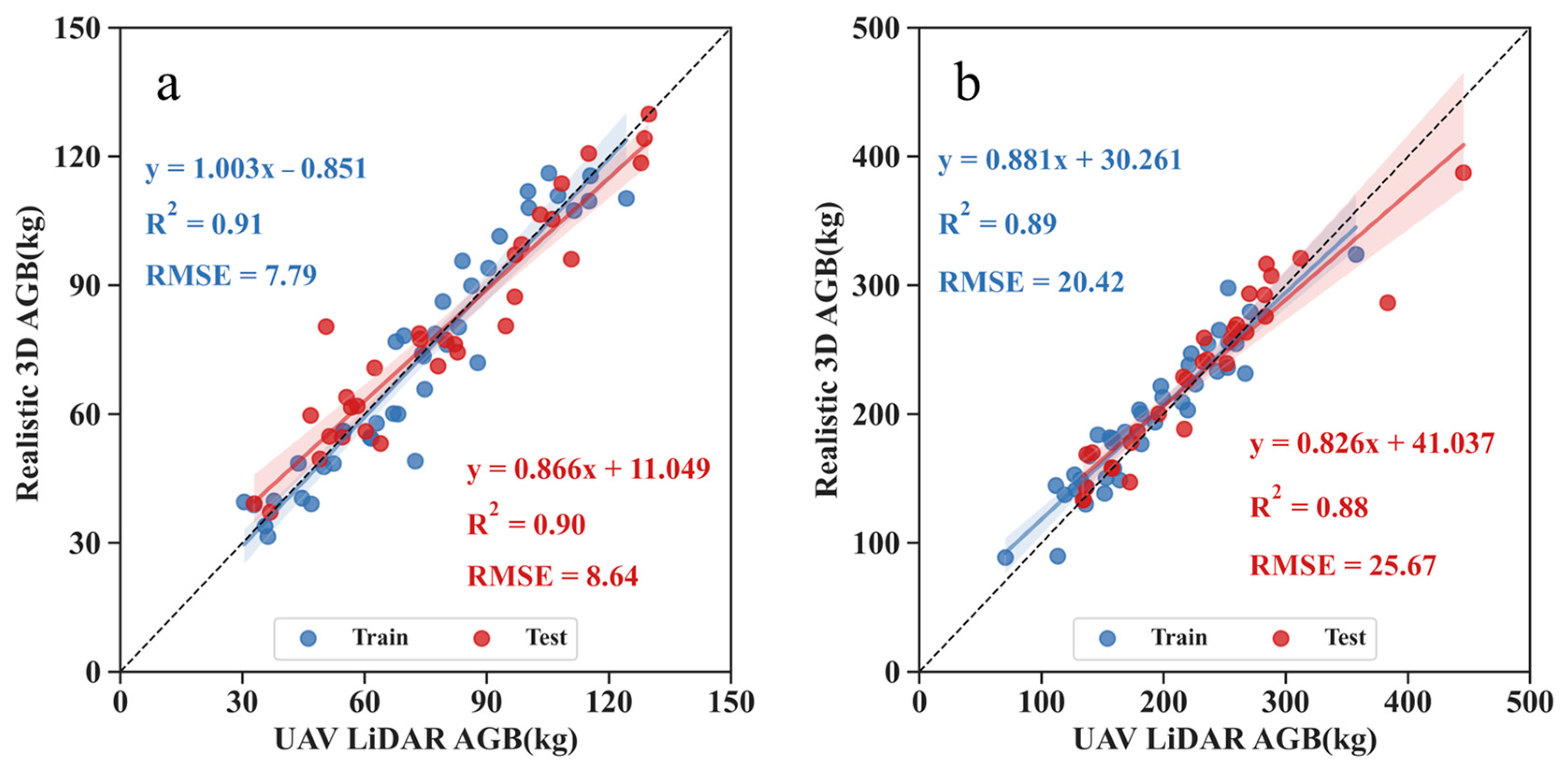
Figure 6 and Table 6 shows the correlation between the results of the 3D real-scene AGB estimation and the UAV-LiDAR AGB results; the coefficients of determination R2 for the training and testing of the ginkgo biomass model estimation were 0.91 and 0.90, respectively, and the RMSEs were 7.79 kg and 8.64 kg, respectively. The R2 values for the training and testing sets of the camphor single-wood biomass estimation were 89 and 0.88, respectively, and the RMSE values were 20.42 kg and 25.67 kg, respectively, indicating that the UAV-based 3D real-scene single-wood AGB estimation can achieve consistent results with LiDAR.

4. Discussion

Unlike LiDAR, which obtains the 3D structure of target features through laser ranging, 3D real scene is a three-dimensional, realistic reproduction of real-world structures and phenology through multiangle aerial photography using virtual means, and RGB images can characterize features such as spectra and the texture of features [49,50]. In this study, we constructed a 3D real-scene model of the study area based on SfM, MVS and other algorithms using aerial images of the UAV in five directions: orthophoto and front, back, left and right, with a clear texture and a resolution of 0.05 m. The model truly inverted the structural characteristics of the two tree species, ginkgo and camphor. The crown diameter is the average of the width of the tree canopy in the north-south and east-west directions, and the branches and leaves at the edges of the tree canopy are relatively sparse, which makes it difficult to obtain relevant information when the density of the UAV laser LiDAR point cloud is low, while the 3D real-scene RGB image can obtain the texture features of the object. This may be the reason behind the higher crown diameter estimates compared to those of LiDAR.
The breast diameter is an important parameter for the construction of forest AGB anisotropic growth models, while the biggest advantage of UAVs, either LiDAR or 3D real scenes, is the ability to obtain parameters such as the tree height, crown diameter, and canopy volume of forest trees [51,52,53,54,55]. However, it is difficult to obtain the diameter at breast height. Therefore, in this study, an AGB estimation model with tree height, crown diameter, and canopy volume as variables was constructed based on linear, power function, logarithmic, and quadratic polynomial models commonly used for single-wood AGB estimation. The results showed that these models can achieve a high accuracy of AGB estimation for two urban tree species, ginkgo and camphor (Table 4), among which the linear model had the highest accuracy of AGB estimation for ginkgo, and the model validation accuracy R2 reached 0.96; the quadratic polynomial model had the highest accuracy of AGB estimation for camphor, and the model validation accuracy R2 reached 0.92. Although it is difficult for UAVs to obtain the diameter of a single tree at breast height, they can be used to obtain the height, crown diameter and canopy volume. These variables can be used to build a new model for AGB and to estimate AGB with high accuracy; this is an important technical means of quickly realizing urban forest AGB estimation and eco-environmental benefit evaluation due to its advantage of obtaining structural parameters such as tree height, crown diameter and canopy volume.
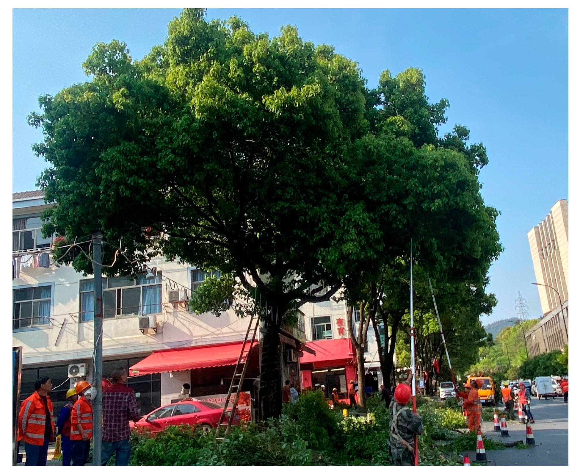
This study showed that the estimation accuracy of the AGB model for ginkgo and camphor constructed based on crown volume and tree height was higher than that of the model constructed according to crown diameter and tree height (Table 4). Urban trees are often truncated and cut to maintain an aesthetic appearance and to avoid interfering with traffic (Figure 7); therefore, canopy 3D parameters such as crown volume are important variables to reflect the size of urban single-wood biomass. For example, Lin et al. [33] used crown diameter combined with tree height to estimate single-wood biomass to achieve a high accuracy. Zhang et al. [29] introduced canopy structure parameters to achieve a high accuracy estimation of AGB in LiDAR-based tree AGB estimation. Zhou et al. [19] calculated the canopy volume using a three-dimensional convex package method and used it as a variable to estimate tree AGB in order to improve the accuracy of AGB estimation.
In this study, we further compared the results of the 3D real-scene-based AGB estimation with the LiDAR-based AGB estimation, and the analysis showed that they had a significant correlation, with R2 reaching values above 0.9 (Figure 6). In addition, Figure 8 also further shows the differences between the 3D real-scene AGB, the measured AGB and the LiDAR AGB. The estimated results are plotted as box plots after removing the outliers according to quartiles and interquartile distances. The quartiles and the median values of the three results are essentially equal. These show that there was no significant difference between the different AGB estimates of the two tree species based on the UAV 3D real-scene, the LiDAR, and the measured AGB for both the training sample and the validation sample, indicating that the urban single-wood AGB estimates based on the UAV 3D real scene can achieve the same results as those of the LiDAR or even the measured AGB. Therefore, based on the UAV 3D real-scene model, single-wood biomass can be estimated with a high accuracy.

5. Conclusions

In this study, based on the multiangle aerial photography of urban street trees acquired using a UAV visible camera, a 3D real-scene model of the study area was constructed to build a 3D real-scene model of urban forest using SfM, MVS and other algorithms; then, the structural parameters, such as tree height, crown diameter and crown volume, of two tree species, ginkgo and camphor, were extracted using the single-wood 3D model, and an AGB estimation model was constructed to achieve a high-accuracy estimation of AGB. The results of this study show that the UAV visible-light 3D real-scene model had a clear texture and realistic inversion of the structural characteristics of two tree species: ginkgo and camphor. There was a significant correlation between the structural parameters, such as tree height, crown volume and crown diameter extracted based on the 3D real-scene model, and the actual measured structures; in addition, the extracted results of crown diameter parameters are better than the UAV-LiDAR estimated structures to some extent. This study showed that the accuracy of the AGB estimation models constructed with tree height and canopy volume as variables was generally higher than that based on tree height and crown diameter, where the model constructed with the highest accuracy of AGB estimation for ginkgo was a linear model, while the model with the highest accuracy of AGB estimation for camphor was a quadratic polynomial model. The UAV visible-light camera for 3D real-scene modeling has the advantages of low cost and portability, and its AGB estimation can reach a high accuracy and almost the accuracy of UAV-LiDAR 3D point clouds; therefore, the UAV 3D real-scene model will have broader application prospects in urban forest resource monitoring, 3D scene reproduction, AGB estimation, ecological environment evaluation and urban refinement management.

Author Contributions

Conceptualization, H.D.; methodology, L.Z. and X.L.; software, L.Z.; validation Y.Z. and L.Z.; formal analysis, Y.Z. and L.Z.; investigation, Y.Z., J.Y., L.L., L.H. and M.S.; resources, H.D.; data curation, C.C., Y.Z. and L.Z.; writing—original draft preparation, Y.Z.; writing—review and editing, H.D., Y.Z. and L.Z.; visualization, H.D.; supervision, H.D.; project administration, H.D.; funding acquisition, H.D. All authors have read and agreed to the published version of the manuscript.

Funding

This research was funded by the Leading Goose Project of Science Technology Department of Zhejiang Province (No. 2023C02035), the National Natural Science Foundation of China (No. U1809208), the Scientific Research Project of Baishanzu National Park (No. 2022JBGS02), the Talent launching project of scientific research and development fund of Zhejiang A & F University (No. 2021LFR029), and the Key Research and Development Program of Zhejiang Province (No. 2021C02005).

Data Availability Statement

Not applicable.

Acknowledgments

The authors gratefully acknowledge the support of various foundations. The authors are grateful to the editor and anonymous reviewers whose comments have contributed to improving the quality of this manuscript.

Conflicts of Interest

The authors declare no conflict of interest.

References

  1. Cai, Z.; Peng, B.; Ji, X.; Ji, P. Construction and application of city-level real 3D city: A case study of Linyi real 3D city. Bullet. Survey. Mapp. 2021, 11, 115–119+144. [Google Scholar]
  2. Zlatanova, S.; Rahman, A.A.; Shi, W. Topological models and frameworks for 3D spatial objects. Comput. Geosci. 2004, 30, 419–428. [Google Scholar] [CrossRef]
  3. Chen, J.; Dowman, I.; Li, S.; Li, Z.; Madden, M.; Mills, J.; Paparoditis, N.; Franz, R.; Sester, M.; Toth, C.; et al. Information from imagery: ISPRS scientific vision and research agenda. ISPRS J. Photogramm. Remote Sens. 2016, 115, 3–21. [Google Scholar] [CrossRef] [Green Version]
  4. Arruda, W.D.S.; Oldeland, J.; Filho, A.C.P.; Pott, A.; Cunha, N.L.; Ishii, I.H.; Damasceno-Junior, G.A. Inundation and Fire Shape the Structure of Riparian Forests in the Pantanal, Brazil. PLoS ONE 2016, 11, e0156825. [Google Scholar] [CrossRef] [Green Version]
  5. Zachmann, L.J.; Shaw, D.W.; Dickson, B.G. Prescribed fire and natural recovery produce similar long-term patterns of change in forest structure in the Lake Tahoe basin, California. For. Ecol. Manag. 2018, 409, 276–287. [Google Scholar] [CrossRef]
  6. Wang, Y.; Lehtomäki, M.; Liang, X.; Pyörälä, J.; Kukko, A.; Jaakkola, A.; Liu, J.; Feng, Z.; Chen, R.; Hyyppä, J. Is field-measured tree height as reliable as believed—A comparison study of tree height estimates from field measurement, airborne laser scanning and terrestrial laser scanning in a boreal forest. ISPRS J. Photogramm. Remote. Sens. 2019, 147, 132–145. [Google Scholar] [CrossRef]
  7. Wiggins, H.L.; Nelson, C.R.; Larson, A.J.; Safford, H.D. Using LiDAR to develop high-resolution reference models of forest structure and spatial pattern. For. Ecol. Manag. 2019, 434, 318–330. [Google Scholar] [CrossRef]
  8. Hartling, S.; Sagan, V.; Maimaitijiang, M.; Dannevik, W.; Pasken, R. Estimating tree-related power outages for regional utility network using airborne LiDAR data and spatial statistics. Int. J. Appl. Earth Obs. Geoinf. 2021, 100, 102330. [Google Scholar] [CrossRef]
  9. Guo, Q.; Hu, T.; Liu, J.; Jin, S.; Xiao, Q.; Yang, G.; Gao, X.; Xu, Q.; Xie, P.; Peng, Z.; et al. Advances in light weight unmanned aerial vehicle remote sensing and major industrial applications. Progress Geogr. 2021, 40, 1550–1569. [Google Scholar] [CrossRef]
  10. Kohek, S.; Žalik, B.; Strnad, D.; Kolmanič, S.; Lukač, N. Simulation-driven 3D forest growth forecasting based on airborne topographic LiDAR data and shading. Int. J. Appl. Earth Obs. Geoinf. 2022, 111, 102844. [Google Scholar] [CrossRef]
  11. Tang, L.; Peng, X.; Chen, C.; Huang, H.; Lin, D. Three-dimensional Forest growth simulation in virtual geographic environments. Int. J. Environ. Sci. Technol. 2019, 12, 31–41. [Google Scholar] [CrossRef]
  12. Liu, W.; Zang, Y.; Xiong, Z.; Bian, X.; Wen, C.; Lu, X.; Wang, C.; Marcato, J.; Gonçalves, W.N.; Li, J. 3D building model generation from MLS point cloud and 3D mesh using multi-source data fusion. Int. J. Appl. Earth Obs. Geoinf. 2023, 116, 103171. [Google Scholar] [CrossRef]
  13. Jia, X.; Zhang, Y.; Du, A. Three-dimensional characterization and calculation of highway space visual perception. Heliyon 2022, 8, e10118. [Google Scholar] [CrossRef]
  14. Wang, C.; Jia, X.; Zhao, Y.; Jin, H.; Liu, L.; Yin, H.; Wang, Z. Review of Methods on Estimating Forest Biomass. J. Beihua Univ. 2019, 20, 391–394. [Google Scholar]
  15. Jayathunga, S.; Owari, T.; Tsuyuki, S. Evaluating the Performance of Photogrammetric Products Using Fixed-Wing UAV Imagery over a Mixed Conifer–Broadleaf Forest: Comparison with Airborne Laser Scanning. Remote. Sens. 2018, 10, 187. [Google Scholar] [CrossRef] [Green Version]
  16. Li, X.; Du, H.; Zhou, G.; Mao, F.; Zhang, M.; Han, N.; Fan, W.; Liu, H.; Huang, Z.; He, S.; et al. Phenology estimation of subtropical bamboo forests based on assimilated MODIS LAI time series data. ISPRS J. Photogramm. Remote. Sens. 2021, 173, 262–277. [Google Scholar] [CrossRef]
  17. Yadav, S.; Padalia, H.; Sinha, S.K.; Srinet, R.; Chauhan, P. Above-ground biomass estimation of Indian tropical forests using X band Pol-InSAR and Random Forest. Remote. Sens. Appl. Soc. Environ. 2021, 21, 100462. [Google Scholar] [CrossRef]
  18. Li, H.; Zhang, G.; Zhong, Q.; Xing, L.; Du, H. Prediction of Urban Forest Aboveground Carbon Using Machine Learning Based on Landsat 8 and Sentinel-2: A Case Study of Shanghai, China. Remote. Sens. 2023, 15, 284. [Google Scholar] [CrossRef]
  19. Zhou, L.; Li, X.; Zhang, B.; Xuan, J.; Gong, Y.; Tan, C.; Huang, H.; Du, H. Estimating 3D Green Volume and Aboveground Biomass of Urban Forest Trees by UAV-Lidar. Remote. Sens. 2022, 14, 5211. [Google Scholar] [CrossRef]
  20. Zuo, S.D.; Ren, Y. Study on the temporal and spatial variation of forest landscape and ecological quality during the fast urbanization process. Environ. Sci. Technol. 2015, 38, 191–198. [Google Scholar] [CrossRef] [Green Version]
  21. Lin, J.; Shu, L.; Zuo, H.; Zhang, B. Experimental observation and assessment of ice conditions with a fixed-wing unmanned aerial vehicle over Yellow River, China. J. Appl. Remote. Sens. 2012, 6, 063586. [Google Scholar] [CrossRef]
  22. Sofonia, J.J.; Phinn, S.; Roelfsema, C.; Kendoul, F.; Rist, Y. Modelling the effects of fundamental UAV flight parameters on LiDAR point clouds to facilitate objectives-based planning. ISPRS J. Photogramm. Remote. Sens. 2019, 149, 105–118. [Google Scholar] [CrossRef]
  23. An, P.T.; Huyen, P.T.T.; Le, N.T. A modified Graham’s convex hull algorithm for finding the connected orthogonal convex hull of a finite planar point set. Appl. Math. Comput. 2021, 397, 125889. [Google Scholar] [CrossRef]
  24. Li, Q.; Li, B.; Cen, J. Research on Laser Range Scanning and lts Application. Geomat. Inform. Sci. Wuhan Univ. 2000, 4, 387–392. [Google Scholar]
  25. Hilker, T.; van Leeuwen, M.; Coops, N.C.; Wulder, M.A.; Newnham, G.J.; Jupp, D.L.B.; Culvenor, D.S. Comparing canopy metrics derived from terrestrial and airborne laser scanning in a Douglas-fir dominated forest stand. Trees Struct. Funct. 2010, 24, 819–832. [Google Scholar] [CrossRef]
  26. Guo, L.; Chehata, N.; Mallet, C.; Boukir, S. Relevance of airborne lidar and multispectral image data for urban scene classification using Random Forests. ISPRS J. Photogramm. Remote. Sens. 2011, 66, 56–66. [Google Scholar] [CrossRef]
  27. Wulder, M.A.; White, J.C.; Nelson, R.F.; Næsset, E.; Ørka, H.O.; Coops, N.C.; Hilker, T.; Bater, C.W.; Gobakken, T. Lidar Sampling for Large-Area Forest Characterization: A Review. Remote Sens. Environ. 2012, 121, 196–209. [Google Scholar] [CrossRef] [Green Version]
  28. Liu, H.; Zhang, Z.; Cao, L. Estimating forest stand characteristics in a coastal plain forest plantation basedon vertical structure profile parameters derived from ALS data. J. Remote Sens. 2018, 22, 872–888. [Google Scholar] [CrossRef]
  29. Zhang, B.; Li, X.; Du, H.; Zhou, G.; Mao, F.; Huang, Z.; Zhou, L.; Xuan, J.; Gong, Y.; Chen, C. Estimation of Urban Forest Characteristic Parameters Using UAV-Lidar Coupled with Canopy Volume. Remote. Sens. 2022, 14, 6375. [Google Scholar] [CrossRef]
  30. Tian, Y.; Zhang, Q.; Huang, H.; Huang, Y.; Tao, J.; Zhou, G.; Zhang, Y.; Yang, Y.; Lin, J. Aboveground biomass of typical invasive mangroves and its distribution patterns using UAV-LiDAR data in a subtropical estuary: Maoling River estuary, Guangxi, China. Ecol. Indic. 2022, 136, 108694. [Google Scholar] [CrossRef]
  31. Wu, P.; Ren, G.; Zhang, C.; Wang, H.; Liu, S.; Ma, Y. Fine identification and biomass estimation of mangroves based on UAV multispectral and LiDAR. Nat. Remote Sens. Bulletin. 2022, 26, 1169–1181. [Google Scholar] [CrossRef]
  32. Fekry, R.; Yao, W.; Cao, L.; Shen, X. Ground-based/UAV-LiDAR data fusion for quantitative structure modeling and tree parameter retrieval in subtropical planted forest. For. Ecosyst. 2022, 9, 100065. [Google Scholar] [CrossRef]
  33. Lin, J.; Chen, D.; Wu, W.; Liao, X. Estimating aboveground biomass of urban forest trees with dual-source UAV acquired point clouds. Urban For. Urban Green. 2022, 69, 127521. [Google Scholar] [CrossRef]
  34. Xu, X.; Zhou, Z.; Tang, Y.; Qu, Y. Individual tree crown detection from high spatial resolution imagery using a revised local maximum filtering. Remote. Sens. Environ. 2021, 258, 112397. [Google Scholar] [CrossRef]
  35. Liu, K.; Cao, L.; Wang, G.; Cao, F. Biomass allocation patterns and allometric models of Ginkgo biloba. J. Beijing For. Univ. 2017, 39, 12–20. [Google Scholar] [CrossRef]
  36. Cao, Z. Biomass and Distribution Pattern of Cinnamomum camphora in Yangzhou. For. Sci. Technol. 2020, 574, 69–71. [Google Scholar]
  37. Iglhaut, J.; Cabo, C.; Puliti, S.; Piermattei, L.; O’Connor, J.; Rosette, J. Structure from Motion Photogrammetry in Forestry: A Review. Curr. For. Rep. 2019, 5, 155–168. [Google Scholar] [CrossRef] [Green Version]
  38. Hu, Q.; Woldt, W.; Neale, C.; Zhou, Y.; Drahota, J.; Varner, D.; Bishop, A.; LaGrange, T.; Zhang, L.; Tang, Z. Utilizing unsupervised learning, multi-view imaging, and CNN-based attention facilitates cost-effective wetland mapping. Remote. Sens. Environ. 2021, 267, 112757. [Google Scholar] [CrossRef]
  39. Xie, L.; Lee, F.; Liu, L.; Yin, Z.; Yan, Y.; Wang, W.; Zhao, J.; Chen, Q. Improved spatial pyramid matching for scene recognition. Pattern Recognit. 2018, 82, 118–129. [Google Scholar] [CrossRef]
  40. Wang, Y.; Liu, X.; Yang, J.; Dang, J. Dense Matching of Multi-View Remote Sensing Terrain lmage Based on lmproved PMVS Algorithm. Laser Optoelectron. Progress 2021, 58, 516–525. [Google Scholar] [CrossRef]
  41. Kang, C.; Cheng, Y.; Shi, L. Application of UAV tilt photography modeling technology in virtual reality. J. Guilin Univ. Technol. 2020, 40, 138–142. [Google Scholar]
  42. Hao, Y.; Zhen, Z.; Li, F.; Zhao, Y. A graph-based progressive morphological filtering (GPMF) method for generating canopy height models using ALS data. Int. J. Appl. Earth Obs. Geoinf. 2019, 79, 84–96. [Google Scholar] [CrossRef]
  43. Fan, Z.; Li, J.; Deng, M. An Adaptive lnverse-Distance Weighting Spatial lnterpolation Method with the Consideration of Multiple Factors. Geomat. Inform. Sci. Wuhan Univ. 2016, 41, 842–847. [Google Scholar] [CrossRef]
  44. Chen, Z.; Liu, Q.; Li, C.; Li, M.; Zhou, X.; Yu, Z.; Su, K. Comparison in linear and nonlinear estimation models of carbon storage of plantations based on UAV LiDAR. J. Beijing For. Univ. 2021, 43, 9–16. [Google Scholar]
  45. Feng, Y.; Lu, D.; Chen, Q.; Keller, M.; Moran, E.; Dos-Santos, M.N.; Bolfe, E.L.; Batistella, M. Examining effective use of data sources and modeling algorithms for improving biomass estimation in a moist tropical forest of the Brazilian Amazon. Int. J. Digit. Earth 2017, 10, 996–1016. [Google Scholar] [CrossRef]
  46. Pati, P.K.; Kaushik, P.; Khan, M.; Khare, P. Allometric equations for biomass and carbon stock estimation of small diameter woody species from tropical dry deciduous forests: Support to REDD+. Trees, For. People 2022, 9, 100289. [Google Scholar] [CrossRef]
  47. Münzinger, M.; Prechtel, N.; Behnisch, M. Mapping the urban forest in detail: From LiDAR point clouds to 3D tree models. Urban For. Urban Green. 2022, 74, 127637. [Google Scholar] [CrossRef]
  48. Qin, H.; Zhou, W.; Yao, Y.; Wang, W. Individual tree segmentation and tree species classification in subtropical broadleaf forests using UAV-based LiDAR, hyperspectral, and ultrahigh-resolution RGB data. Remote. Sens. Environ. 2022, 280, 113143. [Google Scholar] [CrossRef]
  49. Anderson, K.; Gaston, K.J. Lightweight unmanned aerial vehicles will revolutionize spatial ecology. Front. Ecol. Environ. 2013, 11, 138–146. [Google Scholar] [CrossRef] [Green Version]
  50. Zellweger, F.; Braunisch, V.; Baltensweiler, A.; Bollmann, K. Remotely sensed forest structural complexity predicts multi species occurrence at the landscape scale. For. Ecol. Manag. 2013, 307, 303–312. [Google Scholar] [CrossRef]
  51. Geng, L.; Li, M.; Fan, W.; Wang, B. Individual Tree Structure Parameters and Effective Crown of the Stand Extraction Base on Airborn LiDAR Data. Sci. Silvae Sinicae. 2018, 54, 62–72. [Google Scholar] [CrossRef]
  52. Wang, D.; Wan, B.; Liu, J.; Su, Y.; Guo, Q.; Qiu, P.; Wu, X. Estimating aboveground biomass of the mangrove forests on northeast Hainan Island in China using an upscaling method from field plots, UAV-LiDAR data and Sentinel-2 imagery. Int. J. Appl. Earth Obs. Geoinf. 2020, 85, 101986. [Google Scholar] [CrossRef]
  53. Xu, Z.; Shen, X.; Cao, L.; Coops, N.C.; Goodbody, T.R.; Zhong, T.; Zhao, W.; Sun, Q.; Ba, S.; Zhang, Z.; et al. Tree species classification using UAS-based digital aerial photogrammetry point clouds and multispectral imageries in subtropical natural forests. Int. J. Appl. Earth Obs. Geoinf. 2020, 92, 102173. [Google Scholar] [CrossRef]
  54. Donager, J.; Sankey, T.T.; Meador, A.J.S.; Sankey, J.B.; Springer, A. Integrating airborne and mobile lidar data with UAV photogrammetry for rapid assessment of changing forest snow depth and cover. Sci. Remote. Sens. 2021, 4, 100029. [Google Scholar] [CrossRef]
  55. Scheeres, J.; de Jong, J.; Brede, B.; Brancalion, P.H.; Broadbent, E.N.; Zambrano, A.M.A.; Gorgens, E.B.; Silva, C.A.; Valbuena, R.; Molin, P.; et al. Distinguishing forest types in restored tropical landscapes with UAV-borne LIDAR. Remote. Sens. Environ. 2023, 290, 113533. [Google Scholar] [CrossRef]
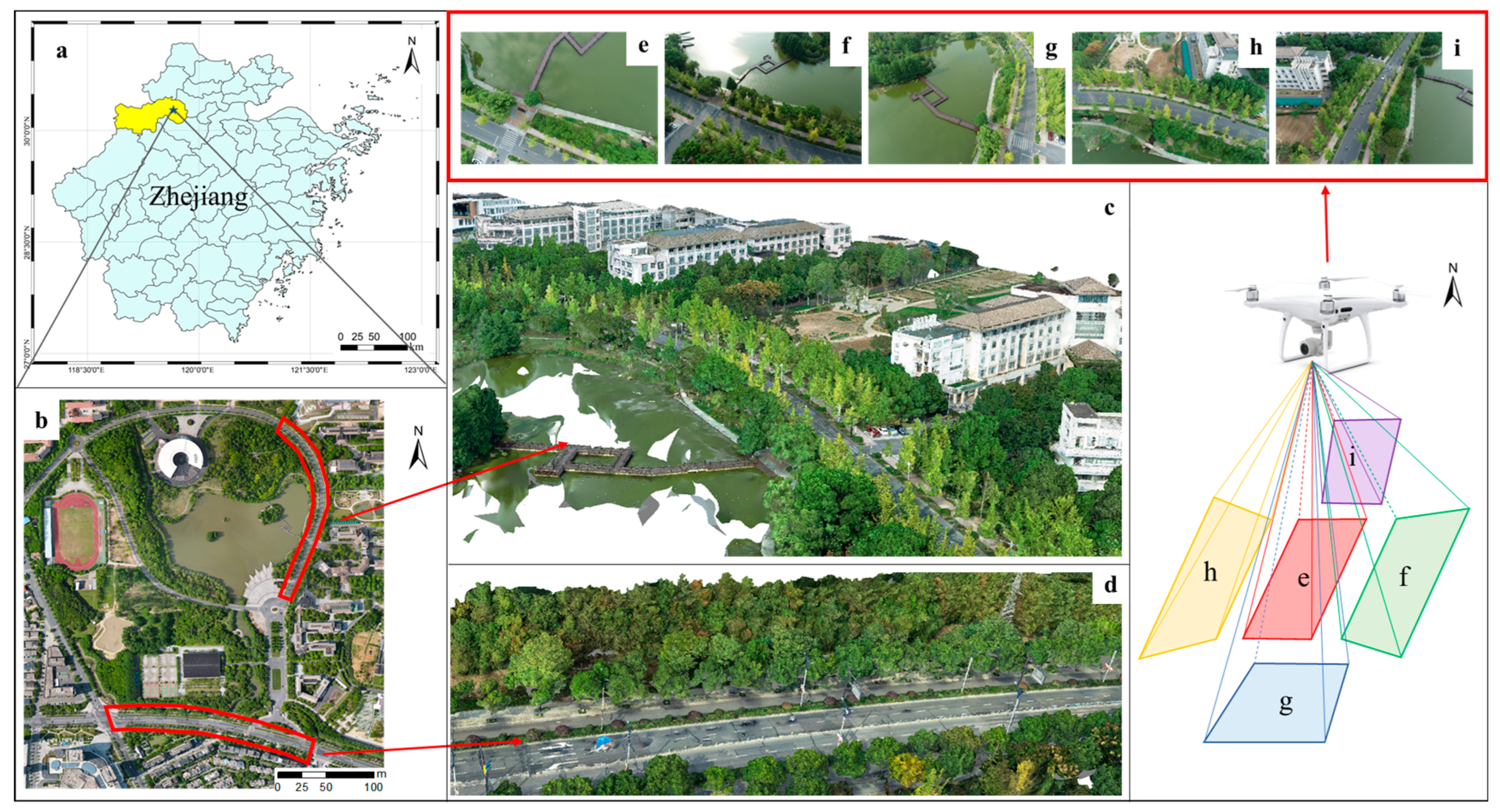
Figure 1. Overview of the study area: (a) location of Lin’an and study area, (b) aerial photograph of the study area, (c) UAV 3D real scene of ginkgo, (d) UAV 3D real scene of the camphor, and (ei) presentations of the same scene from five different perspectives: orthographic, east, south, west, and north.
Drones 07 00455 g001
Figure 2. UAV realistic 3D model construction technology route.
Drones 07 00455 g002
Figure 3. 3D real scene and single-wood schematic ((a) panoramic view, (b) single-wood orthographic schematic, (c) single-wood forward schematic, (d) single-wood backward schematic, (e) single-wood leftward schematic, (f) single-wood rightward schematic, (g) single-wood 3D point cloud and tree height, crown diameter calculation method).
Drones 07 00455 g003
Figure 4. Comparison of the accuracy of the 3D real-scene model and the LiDAR forest parameters ((a) 3D real scene and measured data, (b) 3D real scene and LiDAR).
Drones 07 00455 g004
Figure 5. Accuracy of estimation of the single-wood biomass model for ginkgo and camphor constructed with tree height and crown volume ((a) ginkgo (b) camphor).
Drones 07 00455 g005
Figure 6. LiDAR data to construct the accuracy of single-wood biomass estimation of ginkgo and camphor ((a) ginkgo (b) camphor).
Drones 07 00455 g006
Figure 7. Urban street tree pruning.
Drones 07 00455 g007
Figure 8. Significance analysis of the difference between 3D real-scene AGB and measured AGB and LiDAR AGB ((a) training (b) test).
Drones 07 00455 g008
Table 1. Statistical analysis of ground survey parameters for two tree species.
Tree SpeciesNumberDBH 1 Range/mDBH Mean/mH 2 Range/mH Mean/m
Ginkgo700.149–0.2280.1876.8–14.311.1
Camphora700.157–0.3080.2306.2–11.08.6
1 DBH is diameter at breast height (m). 2 H is tree height (m).
Table 2. Anisotropic growth equations for biomass of two tree species.
Tree SpeciesBiomass Allometric EquationsReferences
Ginkgo ln W = 4.320 + 1.040 · ln ( D 2 H ) [35]
Camphora ln W = 3.491 + 1.033 · ln ( D 2 H ) [36]
Table 3. Single-wood AGB estimation model.
Group 1: Tree Height, Crown DiameterGroup 2: Tree Height, Crown Volume
A G B = a × R c + b × H c   1 A G B = a × V c + b × H c   2
A G B = a × R c 2 + b × H c A G B = a × V c 2 + b × H c
A G B = a × ( R c + H ) b A G B = a × ( V c + H ) b
A G B = a × ( R c × H ) b A G B = a × ( V c × H ) b
A G B = a × ln R c + H b A G B = a × ln V c + H b
A G B = a × ln R c × H b A G B = a × ln V c × H b
1 Rc is the single-wood diameter. 2 Vc is the single-wood crown volume.
Table 4. Models for estimating single-wood biomass with tree height and crown diameter.
SpeciesModelTrainTest
R2RMSE/
(kg)
R2RMSE/
(kg)
GinkgoAGB = 7.029 × Rc + 13.608 × H − 101.1410.918.340.946.62
AGB = 0.847 × R c 2 + 13.503 × H − 85.9780.898.680.947.18
AGB = 0.103 × (Rc + H)2.4150.898.970.928.01
AGB = 0.731 × (Rc × H)1.1910.8410.790.8212.46
AGB = 171.008 × ln(Rc + H) − 387.4960.8610.100.889.78
AGB = 81.401 × ln(Rc × H) − 237.3450.8012.120.8012.70
CamphoraAGB = 1.564 ×Rc + 64.574 × H − 421.2760.8920.750.9030.46
AGB = 0.189 × R c 2 + 63.811 × H − 413.1200.8821.510.9030.09
AGB = 0.133 × (Rc + H)2.5740.6734.290.6749.11
AGB = 1.343 × (Rc × H)1.1680.7430.790.8043.71
AGB = 418.021 × ln(Rc + H) − 983.5880.8127.070.8439.74
AGB = 191.899 × ln(Rc × H) − 617.9970.7729.570.7743.74
Table 5. Models for estimating single-wood biomass with tree height and crown volume.
SpeciesModelTrainTest
R2RMSE/
(kg)
R2RMSE/
(kg)
GinkgoAGB = 0.281 × Vc + 59.488 × H − 385.3140.938.220.966.02
AGB = 0.372   ×   V c 2 + 10.608 × H − 55.1120.918.580.947.15
AGB = 2.624 × (Vc + H)0.7900.908.900.927.96
AGB = 2.121 × (Vc × H)0.5530.889.620.908.66
AGB = 54.151 × ln(Vc+ H) − 150.7330.8412.060.8710.56
AGB = 37.595 × ln(Vc× H) − 162.9580.8311.110.899.60
CamphoraAGB = 0.281 × Vc + 59.488 × H − 385.3140.9119.270.9029.53
AGB = 0.002   ×   V c 2 + 59.686 × H − 376.1650.9020.750.9227.74
AGB = 14.769 × (Vc+ H)0.5690.7729.380.7545.73
AGB = 6.629 × (Vc × H)0.5080.7625.830.7444.37
AGB = 104.272 × ln(Vc+ H) − 274.2720.8031.560.8636.92
AGB = 91.899 × ln(Vc × H) − 412.2140.8321.760.8335.09
Table 6. Statistics of single-wood biomass estimation results.
GinkgoCamphor
TrainTestTrainTest
MinMaxAverageMinMaxAverageMinMaxAverageMinMaxAverage
Field32.60134.8575.2032.85129.7878.3479.72373.32188.34116.14448.85229.28
3D34.36138.0577.8341.60129.4079.8565.30376.88190.22133.32367.42222.70
LiDAR31.49120.2876.5733.55128.7879.0277.37362.26189.87133.84445.48230.39
Disclaimer/Publisher’s Note: The statements, opinions and data contained in all publications are solely those of the individual author(s) and contributor(s) and not of MDPI and/or the editor(s). MDPI and/or the editor(s) disclaim responsibility for any injury to people or property resulting from any ideas, methods, instructions or products referred to in the content.