


Exploring the Feasibility of Mitigating Flood Hazards by an Existing Pond System in Taoyuan, Taiwan

 ,
,  , , ,
, , ,
Abstract
:1. Introduction
1.1. Pond Network in Taoyuan
1.2. Methods for Measuring Inland Waterbodies
1.3. A Novel Bathymetry Technique
2. Methodology
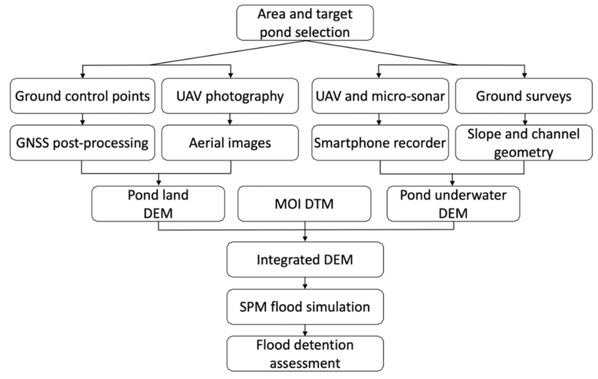
2.1. Workflow
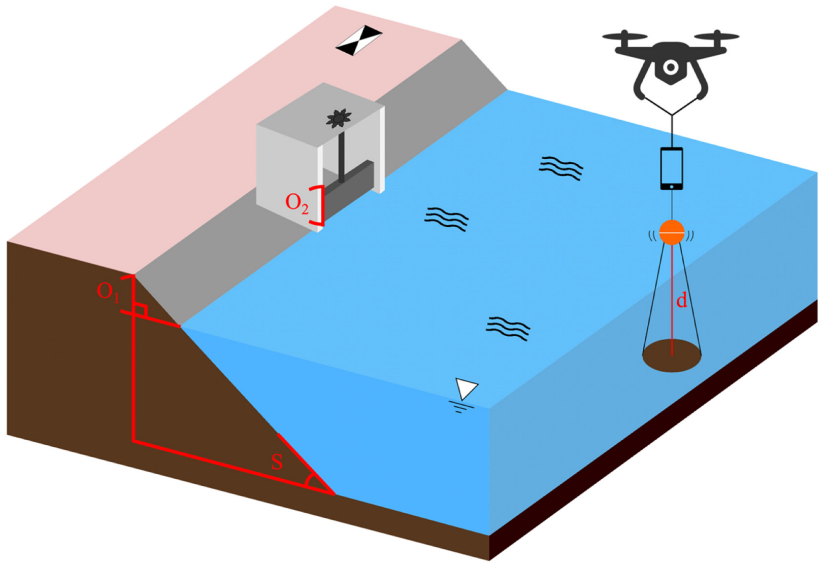
2.2. Fieldwork Procedure
2.2.1. Modeling of Terrain DEM
2.2.2. Modeling of Pond DEM
2.3. Flood Simulation
2.3.1. Simplified Inundation Model (SPM)
2.3.2. A Virtual Channel Scheme to Dissipate Floodwater
3. Result
3.1. Validation of UAV Depth Measurements
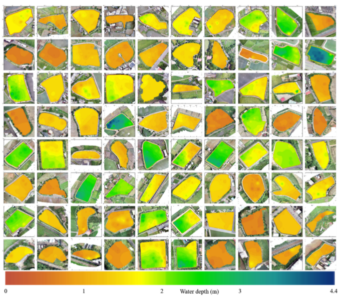
3.2. Validation of Integrated Pond Models
3.3. Design of Drainage Channels from Virtual Network Dissipating Scheme
4. Discussion
5. Conclusions
Author Contributions
Funding
Data Availability Statement
Acknowledgments
Conflicts of Interest
Appendix A

| NUM | ID | S [°] | Min Depth [m] | Max Depth [m] | Estimated Area [m2] | TYWR Area [m2] | Ok [m] | Estimated Storage [m3] | TYWR Storage [m3] |
|---|---|---|---|---|---|---|---|---|---|
| 1 | GI275 | 20 | 1.0 | 2.0 | 68,737 | 71,039 | 0.2 | 106,664 | 163,711 |
| 2 | CL086 | 60 | 0.5 | 1.5 | 36,456 | 39,632 | 0.6 | 51,313 | 22,194 |
| 3 | BD293 | 25 | 1.2 | 1.8 | 24,394 | 24,219 | 0.7 | 45,185 | 31,152 |
| 4 | BD027 | 60 | 0.7 | 1.1 | 25,922 | 25,975 | 0.8 | 39,370 | 39,890 |
| 5 | YM145 | 25 | 1.1 | 2.2 | 21,350 | 22,033 | 0.5 | 39,399 | 67,300 |
| 6 | GI277 | 25 | 1.2 | 2.2 | 64,744 | 62,735 | 0.7 | 134,353 | 145,900 |
| 7 | CL170 | 30 | 0.9 | 2.1 | 31,474 | 29,986 | 0.2 | 43,348 | 16,200 |
| 8 | CL143 | 27 | 1.3 | 2.5 | 62,326 | 64,182 | 0.5 | 133,196 | 4705 |
| 9 | HW256 | 30 | 1.4 | 2.9 | 22,477 | 21,696 | 0.5 | 54,315 | 22,060 |
| 10 | HW279 | 60 | 0.5 | 1.2 | 5732 | 7413 | 0 | 4303 | 12,416 |
| 11 | GI278 | 60 | 0.5 | 0.7 | 9187 | 9824 | 0 | 4915 | 7398 |
| 12 | GI279 | 60 | 0.5 | 0.8 | 23,608 | 25,315 | 0 | 13,343 | 19,063 |
| 13 | GI281 | 30 | 0.8 | 1.5 | 25,078 | 28,369 | 0.6 | 40,726 | 20,450 |
| 14 | GI283 | 60 | 0.5 | 1.2 | 36,175 | 37,414 | 0 | 28,719 | 21,290 |
| 15 | CL186 | 60 | 0.7 | 1.5 | 5693 | 5529 | 0 | 5497 | 1493 |
| 16 | PZ159 | 60 | 1.1 | 1.8 | 8068 | 8104 | 0 | 10,349 | 4537 |
| 17 | PZ160 | 60 | 0.5 | 1.5 | 4289 | 4239 | 0 | 4338 | 2373 |
| 18 | BD031 | 30 | 0.5 | 1.4 | 11,026 | 12,093 | 1.5 | 22,346 | 15,001 |
| 19 | BD032 | 23 | 1.8 | 3.1 | 11,216 | 10,548 | 0.7 | 29,465 | 13,085 |
| 20 | BD033 | 23 | 1.9 | 4.1 | 13,007 | 13,006 | 0.4 | 42,129 | 16,134 |
| 21 | GI260 | 30 | 1.0 | 3.2 | 27,918 | 26,917 | 0.6 | 64,578 | 37,331 |
| 22 | BD089 | 30 | 1.2 | 1.7 | 38,247 | 36,961 | 0.5 | 66,582 | 33,027 |
| 23 | BD090 | 30 | 0.7 | 2.1 | 12,514 | 8411 | 0.5 | 21,510 | 7516 |
| 24 | YM421 | 27 | 1.4 | 2.2 | 8661 | 8402 | 0.1 | 13,431 | 6715 |
| 25 | YM422 | 60 | 1.4 | 1.8 | 2683 | 3610 | 0 | 3530 | 2885 |
| 26 | YM427 | 30 | 0.9 | 1.8 | 6378 | 4918 | 0 | 6985 | 14,990 |
| 27 | PZ047 | 28 | 1.4 | 2.7 | 12,712 | 12,427 | 0.4 | 28,408 | 33,626 |
| 28 | PZ048 | 30 | 1.3 | 2.0 | 6846 | 6510 | 0.3 | 11,599 | 17,616 |
| 29 | CL233 | 35 | 0.8 | 3.5 | 5648 | 9360 | 0.3 | 9371 | 7696 |
| 30 | BD025 | 25 | 0.7 | 1.3 | 11,983 | 12,441 | 0 | 10,278 | 4336 |
| 31 | BD026 | 25 | 0.5 | 1.0 | 4745 | 5118 | 0.4 | 4602 | 1784 |
| 32 | BD010 | 30 | 1.0 | 1.4 | 5788 | 6340 | 0 | 6619 | 5790 |
| 33 | BD011 | 30 | 1.0 | 1.9 | 23,093 | 22,898 | 1 | 48,102 | 47,323 |
| 34 | YM187 | 30 | 2.2 | 4.4 | 40,608 | 38,727 | 0 | 112,656 | 42,380 |
| 35 | YM189 | 30 | 0.9 | 1.7 | 24,959 | 21,433 | 0.4 | 35,428 | 23,454 |
| 36 | YM344 | 22 | 0.7 | 1.9 | 86,244 | 86,085 | 0.7 | 155,564 | 247,140 |
| 37 | CL128 | 60 | 0.5 | 0.8 | 13,516 | 13,763 | 0 | 7378 | 13,073 |
| 38 | CL120 | 26 | 1.5 | 3.0 | 28,955 | 27,882 | 0.5 | 64,892 | 39,693 |
| 39 | YM346 | 25 | 0.5 | 0.9 | 63,450 | 65,130 | 0.4 | 60,790 | 137,743 |
| 40 | HW251 | 60 | 0.5 | 0.7 | 6560 | 6670 | 0.6 | 7169 | 5870 |
| 41 | YM049 | 25 | 2.1 | 2.7 | 21,001 | 21,473 | 0.3 | 47,260 | 60,638 |
| 42 | YM300 | 30 | 1.3 | 2.2 | 21,921 | 20,457 | 0.6 | 46,038 | 70,000 |
| 43 | CL158 | 30 | 0.9 | 2.2 | 14,476 | 14,385 | 0 | 15,972 | 10,450 |
| 44 | YM029 | 25 | 0.8 | 1.5 | 35,804 | 38,775 | 0.5 | 51,139 | 59,900 |
| 45 | YM030 | 25 | 1.9 | 3.4 | 22,437 | 23,245 | 0.8 | 66,584 | 29,072 |
| 46 | YM330 | 25 | 0.9 | 2.7 | 25,951 | 25,184 | 1 | 61,341 | 65,300 |
| 47 | YM375 | 23 | 2.1 | 3.5 | 22,264 | 20,916 | 0 | 49,162 | 30,800 |
| 48 | YM377 | 25 | 1.5 | 2.4 | 15,931 | 18,164 | 1.5 | 46,481 | 126,000 |
| 49 | PZ144 | 30 | 1.9 | 2.2 | 2587 | 3261 | 0.6 | 5918 | 5454 |
| 50 | PZ145 | 30 | 1.4 | 1.9 | 2712 | 2557 | 0.3 | 4618 | 4276 |
| 51 | PZ175 | 30 | 0.9 | 1.3 | 5752 | 5391 | 0.5 | 8314 | 5355 |
| 52 | PZ172 | 60 | 0.6 | 0.8 | 9652 | 10,337 | 0 | 6267 | 6206 |
| 53 | YM051 | 30 | 2.1 | 3.8 | 46,761 | 45,493 | 0.6 | 137,851 | 12,495 |
| 54 | YM052 | 27 | 1.9 | 2.5 | 31,836 | 30,557 | 0.4 | 71,891 | 40,334 |
| 55 | YM343 | 30 | 0.8 | 2.0 | 37,884 | 36,331 | 0.5 | 69,664 | 82,160 |
| 56 | YM082 | 35 | 1.4 | 1.9 | 14,798 | 15,159 | 0 | 21,119 | 5940 |
| 57 | HW294 | 30 | 1.2 | 1.5 | 10,794 | 10,408 | 0 | 13,006 | 11,980 |
| 58 | YM076 | 25 | 0.5 | 1.5 | 52,130 | 51,825 | 1 | 87,449 | 108,110 |
| 59 | YM095 | 23 | 1.1 | 2.0 | 24,241 | 25,701 | 0.6 | 41,776 | 34,469 |
| 60 | YM350 | 25 | 1.1 | 2.1 | 24,434 | 24,433 | 0.5 | 43,389 | 31,618 |
| 61 | YM352 | 25 | 1.7 | 2.5 | 27,336 | 27,713 | 1 | 75,154 | 79,000 |
| 62 | BD075 | 60 | 1.1 | 1.4 | 3639 | 4237 | 0 | 4154 | 2892 |
| 63 | BD036 | 30 | 0.8 | 1.6 | 10,233 | 9402 | 0.6 | 15,025 | 9750 |
| 64 | BD165 | 30 | 0.7 | 1.7 | 10,464 | 10,945 | 0.8 | 17,381 | 13,672 |
| 65 | YM378 | 30 | 1.5 | 2.9 | 36,501 | 37,547 | 0.5 | 82,852 | 63,390 |
| 66 | YM379 | 25 | 1.4 | 3.2 | 21,051 | 23,766 | 0.8 | 53,320 | 68,865 |
| 67 | BD012 | 30 | 1.2 | 1.5 | 5894 | 5382 | 0 | 6943 | 11,123 |
| 68 | CL273 | 60 | 0.5 | 0.7 | 14,079 | 14,365 | 0 | 7722 | 18,810 |
| 69 | CL313 | 30 | 0.9 | 1.3 | 3906 | 4960 | 0 | 4060 | 6205 |
| 70 | YM542 | 30 | 0.5 | 1.4 | 6108 | 6214 | 0.3 | 7016 | 11,380 |
| 71 | YM520 | 30 | 0.9 | 1.7 | 3074 | 3379 | 0 | 3965 | 3210 |
| 72 | YM462 | 30 | 0.8 | 1.2 | 5580 | 6647 | 0.6 | 7979 | 12,330 |
| 73 | YM461 | 60 | 0.5 | 1.8 | 6256 | 7037 | 0 | 5392 | 11,776 |
| 74 | YM147 | 60 | 0.6 | 0.9 | 5090 | 4703 | 0 | 3576 | 10,380 |
| 75 | YM310 | 20 | 0.8 | 2.4 | 26,442 | 26,155 | 0.8 | 61,280 | 82,000 |
| 76 | YM313 | 20 | 1.5 | 3.4 | 27,814 | 26,497 | 0.5 | 66,586 | 36,329 |
| 77 | HW259 | 60 | 0.5 | 0.9 | 3462 | 4333 | 0 | 2192 | 5769 |
| 78 | HW260 | 60 | 0.7 | 1.6 | 4444 | 3856 | 0 | 3904 | 5400 |
| 79 | YM120 | 60 | 0.7 | 1.5 | 6448 | 7145 | 0 | 5347 | 10,298 |
| 80 | YM163 | 30 | 0.8 | 1.5 | 6870 | 5573 | 0 | 6469 | 8034 |
Appendix B

References
- Fang, W.T.; Chu, H.J.; Cheng, B.Y. Modeling waterbird diversity in irrigation ponds of Taoyuan, Taiwan using an artificial neural network approach. Paddy Water Environ. 2009, 7, 209–216. [Google Scholar] [CrossRef]
- Shih, N.J.; Qiu, Y.T. The Morphology of Evolved Urban Fabric around Farm Ponds. Remote Sens. 2021, 13, 437. [Google Scholar] [CrossRef]
- Hakka Affairs Council. Taoyuan Tableland and Ponds. Available online: https://english.hakka.gov.tw/Content/Content?NodeID=692&PageID=42603&LanguageType=ENG (accessed on 1 August 2022).
- Fang, W.; Huang, Y. Modelling Geographic Information System With Logistic Regression In Irrigation Ponds, Taoyuan Tableland. Procedia Environ. Sci. 2012, 12, 505–513. [Google Scholar] [CrossRef] [Green Version]
- Department of Budget, Accounting and Statistics, Taoyuan. Available online: https://dbas.tycg.gov.tw/home.jsp?id=206&parentpath=0,13,47 (accessed on 1 August 2022).
- Wang, J.J. Feasibility Analysis of Using Farm Ponds as Adaptation Tools for Stormwater Management. Int. J. Clim. Chang. Impacts Responses 2013, 4, 71–90. [Google Scholar] [CrossRef]
- Wang, J.J.; Chang, S.S. Detention Analysis of Farm Pond and Ditch Network in Taoyuan City. J. City Plan. 2016, 43, 157–187. (In Chinese) [Google Scholar]
- Kasvi, E.; Salmela, J.; Lotsari, E.; Kumpula, T.; Lane, S. Comparison of remote sensing based approaches for mapping bathymetry of shallow, clear water rivers. Geomorphology 2019, 333, 180–197. [Google Scholar] [CrossRef]
- Xing, S.; Wang, D.D.; Xu, Q.; Lin, Y.Z.; Li, P.C.; Jiao, L.; Zhang, X.L.; Liu, C.B. A Depth-Adaptive Waveform Decomposition Method for Airborne LiDAR Bathymetry. Sensors 2019, 19, 5065. [Google Scholar] [CrossRef] [Green Version]
- Wang, C.K.; Philpot, W.D. Using airborne bathymetric lidar to detect bottom type variation in shallow waters. Remote Sens. Environ. 2007, 106, 123–135. [Google Scholar] [CrossRef]
- Costa, B.M.; Battista, T.A.; Pittman, S.J. Comparative evaluation of airborne LiDAR and ship-based multibeam SoNAR bathymetry and intensity for mapping coral reef ecosystems. Remote Sens. Environ. 2009, 113, 1082–1100. [Google Scholar] [CrossRef]
- Hilldale, R.C.; Raff, D. Assessing the ability of airborne LiDAR to map river bathymetry. Earth Surf. Proc. Land 2008, 33, 773–783. [Google Scholar] [CrossRef]
- Stumpf, R.P.; Holderied, K.; Sinclair, M. Determination of water depth with high-resolution satellite imagery over variable bottom types. Limnol. Oceanogr. 2003, 48, 547–556. [Google Scholar] [CrossRef]
- Getirana, A.; Jung, H.C.; Tseng, K.H. Deriving three dimensional reservoir bathymetry from multi-satellite datasets. Remote Sens. Environ. 2018, 217, 366–374. [Google Scholar] [CrossRef]
- Lurton, X. Introduction to Underwater Acoustics; Springer: Berlin, Germany, 2016. [Google Scholar]
- Nex, F.; Remondino, F. UAV For 3D Mapping Applications: A Review. Appl. Geomat. 2013, 6, 1–15. [Google Scholar] [CrossRef]
- Liu, P.; Chen, A.Y.; Huang, Y.N.; Han, J.Y.; Lai, J.S.; Kang, S.C.; Wu, T.H.; Wen, M.C.; Tsai, M.H. A review of rotorcraft Unmanned Aerial Vehicle (UAV) developments and applications in civil engineering. Smart Struct. Syst. 2014, 13, 1065–1094. [Google Scholar] [CrossRef]
- Fonstad, M.A.; Dietrich, J.T.; Courville, B.C.; Jensen, J.L.; Carbonneau, P.E. Topographic structure from motion: A new development in photogrammetric measurement. Earth Surf. Proc. Land 2013, 38, 421–430. [Google Scholar] [CrossRef] [Green Version]
- Javemick, L.; Brasington, J.; Caruso, B. Modeling the topography of shallow braided rivers using Structure-from-Motion photogrammetry. Geomorphology 2014, 213, 166–182. [Google Scholar] [CrossRef]
- Alvarez, L.V.; Moreno, H.A.; Segales, A.R.; Pham, T.G.; Pillar-Little, E.A.; Chilson, P.B. Merging Unmanned Aerial Systems (UAS) Imagery and Echo Soundings with an Adaptive Sampling Technique for Bathymetric Surveys. Remote Sens. 2018, 10, 1362. [Google Scholar] [CrossRef] [Green Version]
- Bandini, F.; Olesen, D.; Jakobsen, J.; Kittel, C.M.M.; Wang, S.; Garcia, M.; Bauer-Gottwein, P. Technical note: Bathymetry observations of inland water bodies using a tethered single-beam sonar controlled by an unmanned aerial vehicle. Hydrol. Earth Syst. Sci. 2018, 22, 4165–4181. [Google Scholar] [CrossRef] [Green Version]
- Yang, T.H.; Chen, Y.C.; Chang, Y.C.; Yang, S.C.; Ho, J.Y. Comparison of Different Grid Cell Ordering Approaches in a Simplified Inundation Model. Water 2015, 7, 438–454. [Google Scholar] [CrossRef] [Green Version]
- Takasu, T.; Yasuda, A. Development of the low-cost RTK-GPS receiver with an open source program package RTKLIB. In Proceedings of the International Symposium on GPS/GNSS, 2009, International Convention Center, Jeju, Republic of Korea, 4–6 November 2009; Volume 1. [Google Scholar]
- Hung, Y.C.; Wan, H.H.; Tsai, P.Y.; Liao, W.T.; Tseng, K.H. Using UAV with Low-cost Sonar to Measure Parameters of Ponds. J. Photogramm. Remote Sens. 2019, 24, 135–146. (In Chinese) [Google Scholar]
- Kong, S.H. Fast Multi-Satellite ML Acquisition for A-GPS. IEEE T Wirel Commun. 2014, 13, 4935–4946. [Google Scholar] [CrossRef]
- Curtarelli, M.; Leão, J.; Ogashawara, I.; Lorenzzetti, J.; Stech, J. Assessment of spatial interpolation methods to map the bathymetry of an Amazonian hydroelectric reservoir to aid in decision making for water management. ISPRS Int. J. Geo-Inf. 2015, 4, 220–235. [Google Scholar] [CrossRef]
- Henrico, I. Optimal interpolation method to predict the bathymetry of Saldanha Bay. Trans. GIS 2021, 25, 1991–2009. [Google Scholar] [CrossRef]
- Bartier, P.M.; Keller, C.P. Multivariate interpolation to incorporate thematic surface data using inverse distance weighting (IDW). Comput. Geosci. 1996, 22, 795–799. [Google Scholar] [CrossRef]
- Lu, G.Y.; Wong, D.W. An adaptive inverse-distance weighting spatial interpolation technique. Comput. Geosci. 2008, 34, 1044–1055. [Google Scholar] [CrossRef]
- Tarboton, D.G. A new method for the determination of flow directions and upslope areas in grid digital elevation models. Water Resour. Res. 1997, 33, 309–319. [Google Scholar] [CrossRef] [Green Version]
- Bulti, D.; Abebe, B. A Review Of Flood Modeling Methods For Urban Pluvial Flood Application. Model. Earth Syst. Environ. 2020, 6, 1293–1302. [Google Scholar] [CrossRef]
- Hung, Y.C. Using Mobile Bathymetry System to Produce Bathymetry Model in Shallow Water Area. Master’s Thesis, National Central University, Taoyuan City, Taiwan, 2020. [Google Scholar]
- Zheng, S.T. It Rained Heavily in Afternoon in Taoyuan, and Serval Road Sections in Bade Were Flooded. Liberty Times Net. 25 June 2019. Available online: https://news.ltn.com.tw/news/life/breakingnews/2833370. (accessed on 1 August 2022). (In Chinese).
- Department of Public Information, Taoyuan. Available online: https://news.tycg.gov.tw/home.jsp?id=2&parentpath=0&mcustomize=news_view.jsp&dataserno=201708220001&aplistdn=ou=news,ou=chinese,ou=ap_root,o=tycg,c=tw&toolsflag=Y#U (accessed on 1 August 2022). (In Chinese)
- Chou, C.; Weng, M.; Huang, H.; Chang, Y.; Chang, H.; Yeh, T. Monitoring The Spring 2021 Drought Event In Taiwan Using Multiple Satellite-Based Vegetation And Water Indices. Atmosphere 2022, 13, 1374. [Google Scholar] [CrossRef]
- Bouman, B. How much water does rice use. Management 2009, 69, 115–133. [Google Scholar]


Disclaimer/Publisher’s Note: The statements, opinions and data contained in all publications are solely those of the individual author(s) and contributor(s) and not of MDPI and/or the editor(s). MDPI and/or the editor(s) disclaim responsibility for any injury to people or property resulting from any ideas, methods, instructions or products referred to in the content. |
© 2022 by the authors. Licensee MDPI, Basel, Switzerland. This article is an open access article distributed under the terms and conditions of the Creative Commons Attribution (CC BY) license (https://creativecommons.org/licenses/by/4.0/).
Share and Cite
Tseng, K.-H.; Yang, T.-H.; Chen, P.-Y.; Chien, H.; Chen, C.-F.; Hung, Y.-C. Exploring the Feasibility of Mitigating Flood Hazards by an Existing Pond System in Taoyuan, Taiwan. Drones 2023, 7, 1. https://doi.org/10.3390/drones7010001
Tseng K-H, Yang T-H, Chen P-Y, Chien H, Chen C-F, Hung Y-C. Exploring the Feasibility of Mitigating Flood Hazards by an Existing Pond System in Taoyuan, Taiwan. Drones. 2023; 7(1):1. https://doi.org/10.3390/drones7010001
Chicago/Turabian StyleTseng, Kuo-Hsin, Tsun-Hua Yang, Pei-Yuan Chen, Hwa Chien, Chi-Farn Chen, and Yi-Chan Hung. 2023. "Exploring the Feasibility of Mitigating Flood Hazards by an Existing Pond System in Taoyuan, Taiwan" Drones 7, no. 1: 1. https://doi.org/10.3390/drones7010001
APA StyleTseng, K.-H., Yang, T.-H., Chen, P.-Y., Chien, H., Chen, C.-F., & Hung, Y.-C. (2023). Exploring the Feasibility of Mitigating Flood Hazards by an Existing Pond System in Taoyuan, Taiwan. Drones, 7(1), 1. https://doi.org/10.3390/drones7010001