Abstract
The objective of this work was to perform a quantitative analysis of the correlation between the forest burning index and abnormal decrease in river discharge under conditions of the cryolithozone of Siberia. We analyzed the long-term and seasonal variation of river discharge in Central Siberia (Nizhnyaya Tunguska and Podkamennaya Tunguska rivers) and in Eastern Siberia (Aldan, Viluy rivers) together with the forest burning dynamics within the river basins. The data on river discharge were obtained from the archive of The Global Runoff Data Centre for 1939–2015. The relative burned area (RBA) index was calculated from wildfire databases collected using satellite technique for 1996–2017. RBA was evaluated as the ratio of the annual burned area within the river basin to the total area of the river basin. RBA values of 2.5–6.1% per year were considered as extremely high. The analysis of available chronologies of extreme fire events in Central and Eastern Siberia showed high correlation (r > −0.55) with long-term data on the runoff minima. Abnormally low levels of discharge were 68–78% of the averaged annual rate. The most significant response of river discharge to the wildfire effect was shown for the summer–autumn period of the season after extreme burning in mid-summer.
1. Introduction
In Siberia, significant and long-term post-fire effects are observed in the permafrost zone [1,2,3,4]. In particular, these are changes in and degradation of the near-surface layers of permafrost, and short-term and long-term anomalies of temperature and water balance [5,6,7,8,9]. This affects the flow regime of small and medium rivers of Siberia, the supply of which is determined by groundwater (10–25% of total) [10]. Interannual fluctuations and trends in river discharge are mainly associated with climatic processes in Siberia [11,12,13,14], and the results of analyses of wildfire impact on river flows are have not been thoroughly discussed in the literature.
In this work, we determined the degree of connection between intra- and interseasonal variations in river runoff with the relative burned area (RBA) of forests in the river basins of Siberia. The following aspects of the issue were considered: (i) The correlation of long-term data on river flow anomalies and RBA; (ii) the intraseasonal variations of the river flow under post-fire conditions; and (iii) features of post-fire river runoff dynamics.
The study of this issue allows us to predict the long-term response of the boreal ecosystems to the fire impact, one of the most significant factors under current climate conditions and fire regimes [3,13].
2. Results
Data on fires and river discharge are presented in Table 1.

Table 1.
Long-term mean of discharge anomalies and relative burned area (RBA; γmean ± σ, γmax) for the river basin territories.
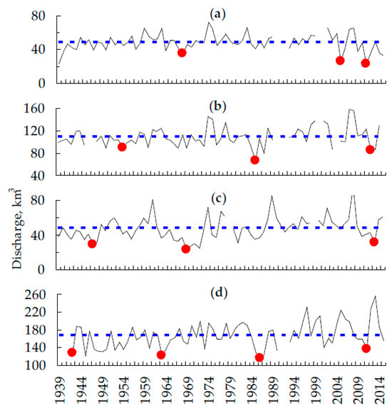
In some seasons, we fixed the level of runoff at 68–78% of the average annual rate. When analyzing the available chronologies of extreme fire events in Central and Eastern Siberia [15,16,17,18], it was possible to compare the discharge minima with extreme fire events (Figure 1). The frequency of extremely low runoffs, ranging from 18 to 25 years, is consistent with the reported data on the variability of the width of the tree rings in larch forests of Central Siberia [19], which is determined by the temperature and the moisture regimes of weather. Thus, the phase coincidence of the flow anomalies and extreme fire events associated with the precipitation deficit is expected.

Figure 1.
Long-term data on total annual runoff (km3). The dots indicate the minima which correspond to the dates of extreme fire events. Dotted line—annual mean value. River basins: (a) Podkamennaya Tunguska; (b) Lower Tunguska; (c) Viluy; and (d) Aldan.
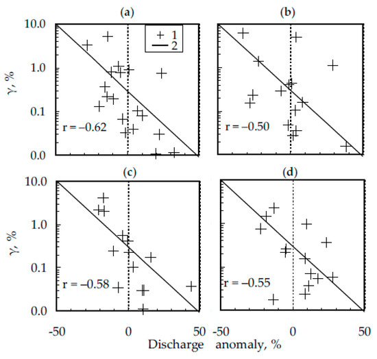
To solve the problem of quantitative descriptions of the relationship, we jointly analyzed data on the forest fire in the borders of river basins (γ, %) and runoff anomalies for the first half of the growing season (March–July) for 2002–2015 (Figure 2). The results of the correlation analysis of the relationship between the intraseasonal dynamics of the discharge and the RBA are presented in (Table 2).

Figure 2.
Correlation field for RBA within the river basins (γ, %) and discharge anomalies for the first half of the vegetation season (March–July) for the rivers of Yakutia: Aldan (a), Viluy (b) and Central Siberia: Podkamennaya Tunguska (c), Lower Tunguska (d). 1—experimental data, 2— linear model.

Table 2.
Correlation between discharge anomalies and RBA during the season.
3. Discussion
In Ref. [14], it was shown that the data on the moisture content in the soil are an effective indicator of the prediction of forest burning in the permafrost zone of Siberia. At the same time, it is noted that the moisture reserves in the soil in the current season determines the degree of fire danger of this and the subsequent season. To use these results in fire monitoring practice requires a wide network of data collection points, which is not always possible to implement in remote areas of Central and Eastern Siberia. An alternative solution is the development of methods for remote monitoring of water mass dynamics according to gravimetric survey data [1,20]. In our work, a qualitatively similar result was obtained, while the data on anomalies of river discharge are a more effective criterion for predicting the fire regime within the river basins.
The response to the fire impact was also recorded in the territories of the considered basins of the rivers in Central Siberia, which expressed an abnormal low discharge in the post-fire summer–autumn period (r > −0.55). At the same time, the level of relation is lower for the basins of rivers in Eastern Siberia/Yakutia (r < −0.45).
The revealed differences can be a consequence of the post-fire condition of permafrost soils, which determines the share of groundwater in the formation of the total river flow. The post-fire transformation of vegetation and on-ground cover can be the cause of heat and water balance anomalies [17,21], changes in the depth of seasonally thawed layers of soils, or changes in water permeability of soil horizons [22,23]. Thus, if we do not take into account seasonal variations in the precipitation regime, the features of the post-fire discharge anomalies are determined by the interdependency of “fire effect”, “ground cover and vegetation”, and “soil”. The influence of wildfires is significant only for the seasonally thawed layer that is active in the summer–autumn period.
A more detailed study of post-fire effects on river discharge anomalies is important for predicting the response of boreal ecosystems to the fires effects, which currently tends to increase [1,4,24].
4. Materials and Methods
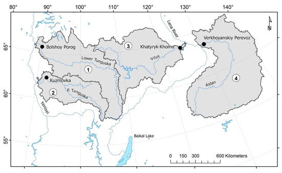
The area of interest is the territory of Siberia within the boundaries of 57–67 N, 85–110 E. The total area is more than 110 million hectares. The studies were performed for four river basins of Central Siberia and Yakutia (Figure 3), such as Lower Tunguska, Podkamennaya Tunguska (Basin District of Yenisei River), and Aldan, Viluy (Basin District of Lena River).

Figure 3.
Area of interest. River basins and hydrological points for data collection. River basins are 1—Lower Tunguska, 2—Podkamennaya Tunguska, 3—Viluy, and 4—Aldan.
The long-term data on the flow rate (m3/s) and river discharge (km3) were compiled from the open database R-ArcticNET 4.0 (http://www.R-ArcticNET.sr.unh.edu), an integrated monitoring system Arctic-RIMS (Rapid Integrated Monitoring System; UNH Earth Systems Research Center, Durham, NH, USA, http://rims.unh.edu/index.shtml), The Global Runoff Data Center (http://www.bafg.de), and Composite Runoff Field V 1.0 (http: //www.compositerunoff.sr.unh.edu/) [25,26,27]. We analyzed the monthly average water runoff for 1936–2015 at the following hydrological posts: Bolshoy Porog (basin of Lower Tunguska), Kuzmovka (basin of Podkamennaya Tunguska), Khatyryk-Khomo (basin of Viluy River), Verkhoyanskiy Perevoz (basin of Aldan River).
We determined the average annual value of the discharge () and analyzed deviations () from the average statistical norm (discharge anomalies) for the each month (i) as
We determined the relative burned area (RBA) of forests within the river basins on the basis of satellite fire monitoring data of the Sukachev Institute of Forest (Federal Research Center KSC SB RAS, Krasnoyarsk, Russia). The data were presented in the format of a geoinformation (Geographic Information System, GIS) wildfire database for 1996–2015 [28]. RBA (γ) was defined for each month as the ratio of the total area of fires (Sburned) to the total area of the river basin (S):
Data processing was performed using geospatial pre-processing of vector data layers using GIS tools, correlation and statistical analysis, and a method for the optimization of regression coefficients.
5. Conclusions
For the current river basins, the scale of wildfire impact is up to 2.5–6.1% of the total area per year. Its effects are strong on the forest ecosystems of the permafrost zone. Within the river basins of Central Siberia, the response to pyrogenic (post-fire) impact is expressed in anomalies of discharge in the post-fire summer–autumn period (r > −0.52). For river basins in Eastern Siberia, the correlation is lower. The level of significance is determined as highly likely by the state of and post-fire changes in the permafrost soil conditions.
Author Contributions
Conceptualization, E.I.P. and T.V.P.; methodology, E.I.P.; writing—original draft preparation, E.I.P. and T.V.P.; writing—review and editing, E.I.P.; funding acquisition, E.I.P., T.V.P.
Acknowledgments
This research was funded by the Russian Foundation for Basic Research (RFBR) grant number 17-04-00589 “Radiometric method for quantitative analysis of soils structure organization”, RFBR and Government of the Krasnoyarsk krai, and Krasnoyarsk krai Foundation for Research and Development Support, grant number 18-41-242003 “Modeling and satellite monitoring of effects from thermal anomalies of he underlying surface in the seasonally thawed soil layer of the permafrost zone of Siberia”. River discharge data were provided by The Global Runoff Data Centre, 56068 Koblenz, Germany. The satellite data-receiving equipment used was provided by the Regional Center for Remote Sensing, Federal Research Center “Krasnoyarsk Science Center, Siberian Branch of Russian Academy of Sciences”, Krasnoyarsk, Russia.
Conflicts of Interest
The authors declare no conflict of interest.
Abbreviations
The following abbreviations are used in this manuscript:
| RBA | Relative burned area |
| RIMS | Rapid Integrated Monitoring System |
| RD | river discharge |
| KSC SB RAS | Krasnoyarsk Science Center of Siberian Branch of Russian Academy of Sciences |
| GIS | Geographic Information System |
References
- Forkel, M.; Thonicke, K.; Beer, C.; Cramer, W.; Bartalev, S.; Schmullius, C. Extreme fire events are related to previous-year surface moisture conditions in permafrost-underlain larch forests of Siberia. Environ. Res. Lett. 2012, 7, 044021. [Google Scholar] [CrossRef]
- Kharuk, V.I.; Dvinskaya, M.L.; Petrov, I.A.; Im, S.T.; Ranson, K.J. Larch Forests of Middle Siberia: Long-Term Trends in Fire Return Intervals. Reg. Environ. Chang. 2016, 8, 2389–2397. [Google Scholar] [CrossRef] [PubMed]
- Kharuk, V.I.; Ponomarev, E.I. Spatiotemporal characteristics of wildfire frequency and relative area burned in larch-dominated forests of Central Siberia. Rus. J. Ecol. 2017, 48, 507–512. [Google Scholar] [CrossRef]
- Ponomarev, E.I.; Kharuk, V.I.; Ranson, J.K. Wildfires Dynamics in Siberian Larch Forests. Forests 2016, 7, 125. [Google Scholar] [CrossRef]
- Anisimov, O.A.; Sherstiukov, A.B. Evaluating the effect of environmental factors on permafrost in Russia. Earth’s Cryosph. 2016, XX, 90–99. (In Russian) [Google Scholar]
- Bezkorovaynaya, I.N.; Borisova, I.V.; Klimchenko, A.V.; Shabalina, O.M.; Zakharchenko, L.P.; Il’in, A.A.; Beskrovny, A.K. Influence of the pyrogenic factor on the biological activity of the soil in permafrost conditions (Central Evenkia). Vestnik KrasGAU 2017, 9, 181–189. (In Russian) [Google Scholar]
- Desyatkin, R.V.; Desyatkin, A.R. Temperature regime of solonetzic meadow-chernozemic permafrost-affected soil in a long-term cycle. Euras. Soil Sci. 2017, 50, 1301–1310. [Google Scholar] [CrossRef]
- Onuchin, A.A. The reasons for conceptual contradictions in evaluating hydrological role of boreal forests. Sib. J. For. Sci. 2015, 2, 41–54. (In Russian) [Google Scholar] [CrossRef]
- Brown, D.R.N.; Jorgenson, M.T.; Kielland, K.; Verbyla, D.L.; Prakash, A.; Koch, J.C. Landscape Effects of Wildfire on Permafrost Distribution in Interior Alaska Derived from Remote Sensing. Rem. Sens. 2016, 8, 22. [Google Scholar] [CrossRef]
- Water of Russia. Electronic Resource. Available online: http://water-rf.ru/ (accessed on 18 October 2018).
- Georgiadi, A.G.; Kashutina, E.A. Long-term runoff changes of the largest Siberian Rivers. Izv. Rus. Akad. Sci. Ser. Geograph. 2016, 5, 70–81. [Google Scholar] [CrossRef]
- Shiklomanov, A.I.; Lammers, R.B.; Rawlins, M.A.; Smith, L.C.; Pavelsky, T.M. Temporal and spatial variations in maximum river discharge from a new Russian data set. J. Geophys. Res. 2007, 112, 14. [Google Scholar] [CrossRef]
- Ponomarev, E.I.; Skorobogatova, A.S.; Ponomareva, T.V. Wildfire Occurrence in Siberia and Seasonal Variations in Heat and Moisture Supply. Rus. Meteorol. Hydrol. 2018, 43, 456–463. [Google Scholar] [CrossRef]
- Bartsch, A.; Balzter, H.; George, C. Influence of regional surface soil moisture anomalies on forest fires in Siberia observed from satellites. Environ. Res. Lett. 2009, 4, 9. [Google Scholar] [CrossRef]
- Arbatskaya, M.K. The Long-Term Variability of Climate, Trees Growth and Fires Frequency in the Taiga of Central Siberia. Ph.D. Thesis, Krasnoyarsk, Institute of Forest SB RAS, Russia, 1998. (In Russian). [Google Scholar]
- Valendik, E.N.; Ivanova, G.A. Extreme fire seasons in the boreal forests of Central Siberia. For. Sci. 1996, 4, 12–19. (In Russian) [Google Scholar]
- Kharuk, V.I.; Dvinskaya, M.L.; Ranson, K.J. Spatio-temporal dynamics of fires in the larch forests of the northern taiga of Central Siberia. Rus. J. Ecol. 2005, 5, 1–10. (In Russian) [Google Scholar]
- Ivanova, G.A. The history of forest fire in Russia. Dendrochronology 1999, 16–17, 147–161. [Google Scholar]
- Panuyshkina, I.P.; Arbatskaya, M.K. Dendrochronological approach to Study of Flammability of Forests in Evenkia (Siberia). Cont. Probl. Ecol. 1999, 2, 167–173. (In Russian) [Google Scholar]
- Im, S.T.; Kharuk, V.I. Water mass dynamics in permafrost of Central Siberia based on GRACE gravity data Izvestiya. Atmos. Ocean. Phys. 2015, 51, 806–818. [Google Scholar] [CrossRef]
- Ponomarev, E.I.; Ponomareva, T.V. The Effect of Postfire Temperature Anomalies on Seasonal Soil Thawing in the Permafrost Zone of Central Siberia Evaluated Using Remote Data. Cont. Probl. Ecol. 2018, 11, 420–427. [Google Scholar] [CrossRef]
- Dymov, A.A.; Dubrovsky, Y.A.; Gabov, D.N. Pyrogenic Changes in Iron-Illuvial Podzols in the Middle Taiga of the Komi Republic. Euras. Soil Sci. 2014, 47, 47–56. [Google Scholar] [CrossRef]
- Krasnoshchekov, Y.N.; Evdokimenko, M.D.; Dorjsuren, C. Fire Impact on Subtaiga Larch Forest Ecosystems of the Eastern Khentey Area in Mongolia. Sib. J. For. Sci. 2014, 3, 53–63. (In Russian) [Google Scholar]
- Flannigan, M.; Stocks, B.; Turetsky, M.; Wotton, M. Impacts of climate change on fire activity and fire management in the circumboreal forest. Glob. Change Biol. 2009, 15, 49–560. [Google Scholar] [CrossRef]
- Bring, A.; Shiklomanov, A.; Lammers, R.B. Pan-Arctic river discharge: Prioritizing monitoring of future climate change hot spots. Earth’s Future 2017, 5, 72–92. [Google Scholar] [CrossRef]
- Holmes, R.M.; Shiklomanov, A.I.; Tank, S.E.; McClelland, J.W.; Tretiakov, M. River Discharge. Arctic Report Card: Update for 2015. Available online: https://www.arctic.noaa.gov/Report-Card/Report-Card-2015/ArtMID/5037/ArticleID/227/River-Discharge (accessed on 18 October 2018).
- Lehner, B.; Grill, G. Global river hydrography and network routing: Baseline data and new approaches to study the world’s large river systems. Hydrolog. Proc. 2013, 27, 2171–2186. [Google Scholar] [CrossRef]
- Ponomarev, E.I.; Shvetsov, E.G. Satellite detection of forest fires and GIS-methods for result calibration. Issled. Zemli iz Kosmosa (Remote Sens.) 2015, 1, 84–91. (In Russian) [Google Scholar] [CrossRef]
Publisher’s Note: MDPI stays neutral with regard to jurisdictional claims in published maps and institutional affiliations. |
© 2018 by the authors. Licensee MDPI, Basel, Switzerland. This article is an open access article distributed under the terms and conditions of the Creative Commons Attribution (CC BY) license (https://creativecommons.org/licenses/by/4.0/).