Abstract

Centimeter-Accurate Railway Key Objects Detection Using Point Clouds Acquired by Mobile LiDAR Operating in the Infrared †

1
“Nello Carrara” Applied Physics Institute-National Research Council of Italy (CNR-IFAC), 50019 Sesto Fiorentino, Italy
2
Te.Si.Fer Srl, 50127 Firenze, Italy
3
Durazzani Srl Territorio e Ambiente, 50142 Firenze, Italy
*
Author to whom correspondence should be addressed.
Presented at the 18th International Workshop on Advanced Infrared Technology and Applications (AITA 2025), Kobe, Japan, 15–19 September 2025.
Proceedings 2025, 129(1), 39; https://doi.org/10.3390/proceedings2025129039
Published: 12 September 2025

Abstract

The automatic detection and accurate geolocation of key railway objects plays a crucial role in the mapping, monitoring and management of railway infrastructure. This study presents a novel approach for the identification and geolocation of key railway elements through point cloud analysis. The methodology relies on high-density LiDAR point clouds acquired along railway lines using a mobile laser-scanning system operating in the infrared (IR). This research contributes to the advancement of railway mapping and monitoring technologies by providing an innovative solution that can be integrated into railway infrastructure management software.

1. Introduction

In European and international railway design, the need for interoperability between technological systems-such as ERTMS [1] and the systems that make up the railway infrastructure requires the development of increasingly accurate and effective processes and procedures for the collection and digitalization of data. The “NeMeSy-RAIL” project, funded by Regione Toscana in 2024, has been proposed with the aim to answer to this need, making the detection and digitalization of data for the design of ERTMS systems more accurate and effective, thanks to the adoption of a new mobile mapping system (MMS) equipped also with two mobile LiDAR systems working in the infrared and the development of an automated image-processing procedure for the identification and precise geolocation of key objects in the railway system. LiDAR systems are renowned for precise mapping and their extensive range [2]. The digital output of LiDAR systems is a 3D point cloud. A point cloud contains very precise spatial information; however, this information is not ordered and not structured, making recognizing objects of interest challenging. This paper is focused on the development of an automatic point-cloud-processing procedure for the accurate key object detection of railway infrastructure.

2. Materials and Methods

The MMS employed to acquire the dataset analyzed in this paper is the Leica TRK700 Evo from Leica Geosystems (Heerbrugg, Switzerland) [3]. Its main characteristics are reported in Table 1, while the system is depicted in Figure 1a. Figure 1b shows the track of the San Donato railway test circuit, where the dataset was acquired. The San Donato test circuit is 5.759 m long and was completely acquired with 73 raw point clouds intheWCS (World Coordinate System) of approximately 1 GB each. Many techniques are reported in the literature for processing 3D point clouds data, based on both classical data processing and machine learning approaches [4]; unfortunately, the lack of a common test dataset prevents us from making comparisons between the different developed methods. For now, in the NeMeSy-RAIL project, we have decided to process the data using a classical approach, mostly because we only have a dataset with quite homogeneous characteristics. We have implemented an original procedure in MATLAB® (version 2025) from MathWorks (Natick, MA, USA), whose block diagram is depicted in Figure 2. It is mainly based on a statistical analysis approach. The key objects to be identified are the balises (Figure 1c).

3. Results

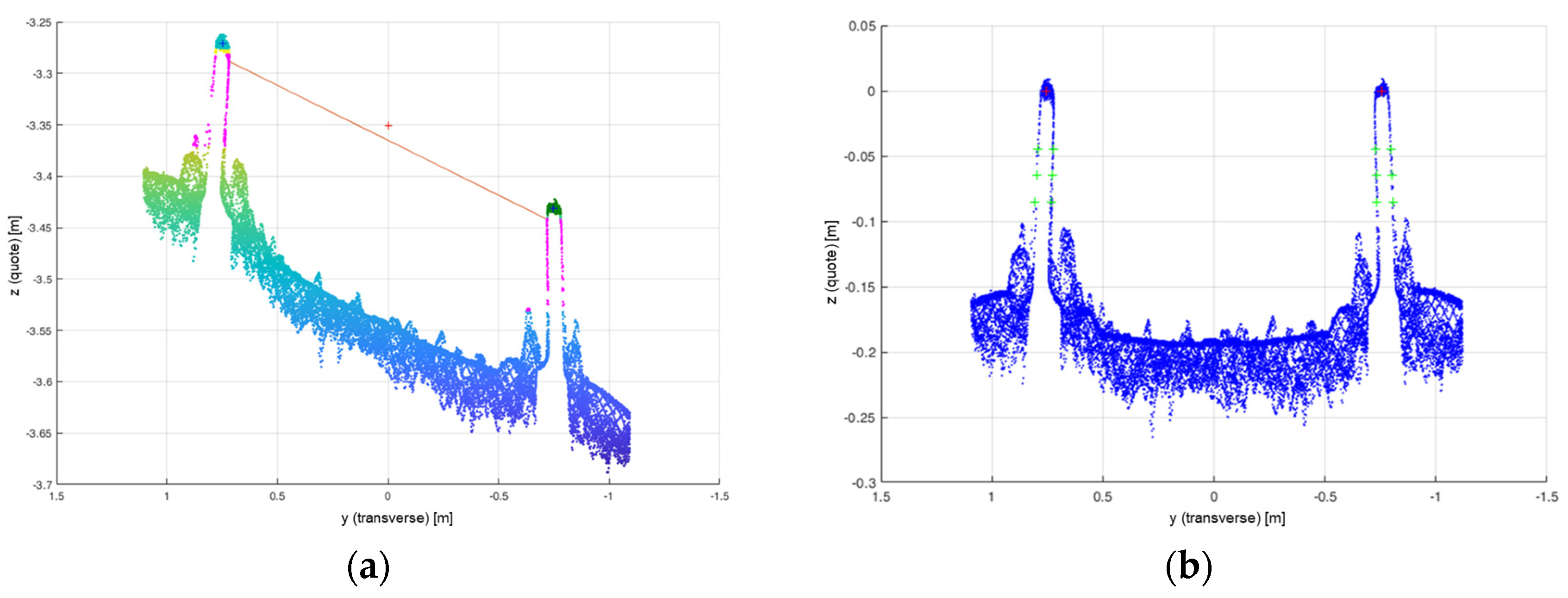
The procedure described in Figure 2 was applied to the entire dataset of 73 LAS files, along the full 5.797 m of the test circuit. Figure 3 shows two scatterplots for a 25 cm section located in one of the main curved regions of the circuit. Figure 3a reports a section of the original point cloud, while Figure 3b shows the same section after the change in coordinate system, which was correctly centered and rotated to compensate for the difference in height of the two rails. This was particularly evident in curves and permitted to have the top of rails at the z = 0 quote. This operation, which is completely invertible, section by section, facilitates the identification of balises, allowing the entire route to be equalized in terms of orientation, inclination, and roll.
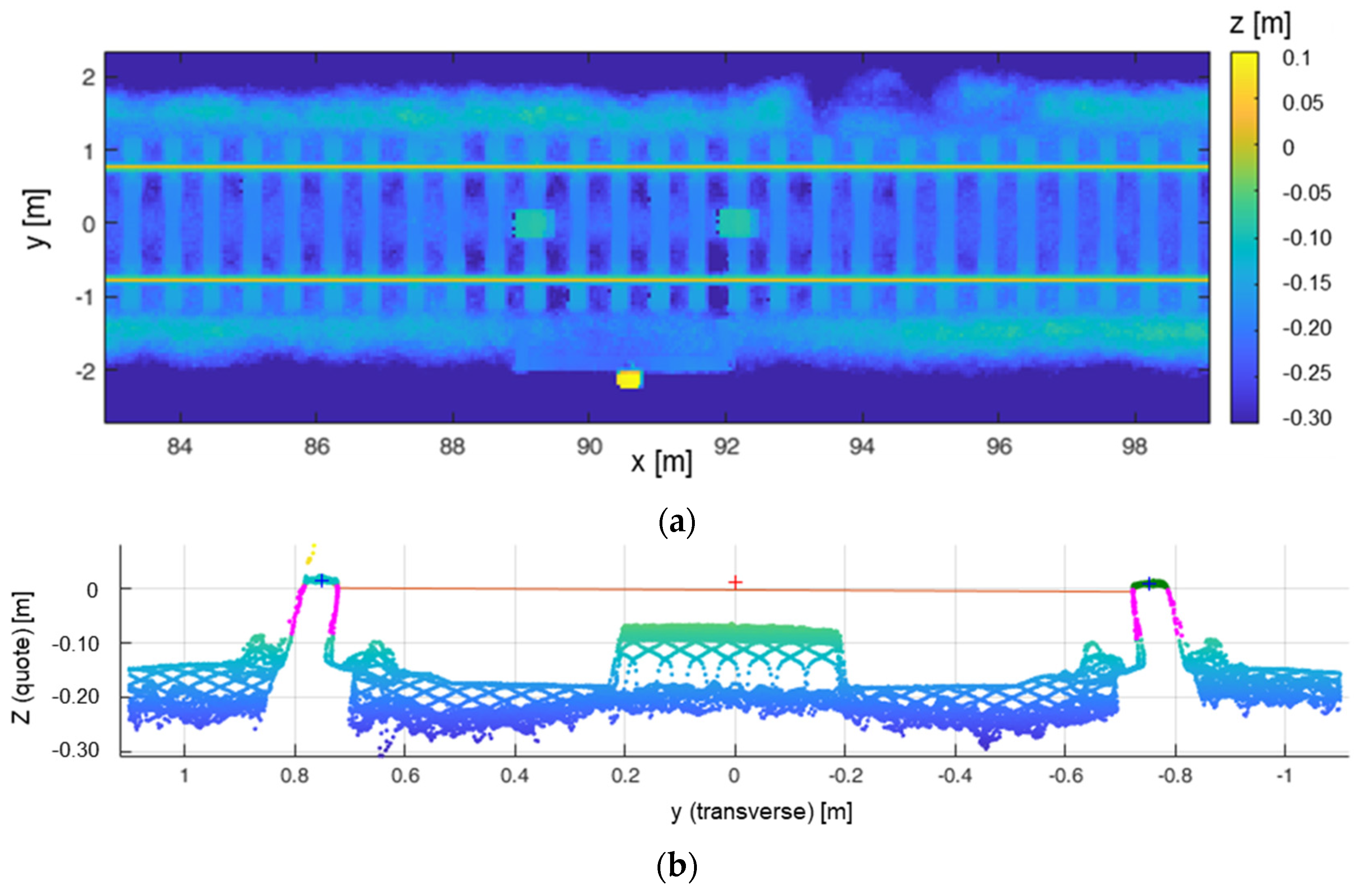
Figure 4a shows, as an example, the quote of a section along the trajectory as it would be seen from above, in which two balises are clearly visible. Figure 4b represents a scatterplot for a 25 cm transverse section containing a balise. Table 2 reports the scores of the procedure in terms of accuracy, precision, and recall [4] for the three detection strategies. All the three methods work well, but the smoothness method gives the better results. Seventy-two balises are present in the S. Donato circuit.

4. Discussion

We have developed an original procedure capable of identifying all the balises in the circuit, by processing the 3D point cloud dataset acquired by means of a LIDAR working in the IR. Thanks to the excellent detection performances, the center of the balises are identified with centimetric precision (the same as the LIDAR itself). We have chosen to make use of a classical data-processing algorithm because the uniformity of the only available dataset could cause overfitting problems if processed with a machine learning algorithm. If other datasets become available in future, experiments with those methods will be carried out.

Author Contributions

Conceptualization, C.L., L.P. and V.R.; methodology, C.L. and L.P.; software, L.P.; validation, C.L., D.P. and A.M.; formal analysis, C.L. and L.P.; investigation, C.L. and L.P.; resources, D.P. and A.M.; data curation, L.P. and A.M.; writing—original draft preparation, C.L.; writing—review and editing, C.L.,L.P. and V.R.; visualization, L.P.; supervision, V.R.; project administration, S.D. and C.L.; funding acquisition, S.D. and C.L. All authors have read and agreed to the published version of the manuscript.

Funding

This research was funded by REGIONE TOSCANA, PR FESR TOSCANA 2021–2027, AZIONE 1.1.4 Ricerca e sviluppo per le imprese anche in raggruppamento con organismi di ricerca. BANDO N.2: Progetti di R&S per MPMI e Midcap. CUP ST 27717.29122023.043000431. Name of the project: NeMeSy- RAIL.

Informed Consent Statement

Not applicable.

Data Availability Statement

The datasets presented in this article are not readily available because the data are part of an ongoing study. Requests to access the datasets should be directed to c.lastri@ifac.cnr.it.

Conflicts of Interest

Simone Durazzani and Daniele Poggi were employed by the company Te.Si.Fer Srl, and Alessio Morabito was employed by the company Durazzani Srl Territorio e Ambiente. The remaining authors declare that the research was conducted in the absence of any commercial or financial relationships that could be construed as a potential conflict of interest.

References

  1. European Rail Traffic Management System (ERTMS). Available online: https://www.era.europa.eu/domains/infrastructure/european-rail-traffic-management-system-ertms_en (accessed on 21 May 2025).
  2. Di Stefano, F.; Chiappini, S.; Gorreja, A.; Balestra, M.; Pierdicca, R. Mobile 3D scan LiDAR: A literature review. Geomat. Nat. Hazards Risk 2021, 12, 2387–2429. [Google Scholar] [CrossRef]
  3. Leica Geosystems. Available online: https://leica-geosystems.com/it-it/products/mobile-mapping-systems/hardware/leica-pegasus-trk-evo (accessed on 21 May 2025).
  4. Dekker, B.; Ton, B.; Meijer, J.; Bouali, N.; Linssen, J.; Ahmed, F. Point Cloud Analysis of Railway Infrastructure: A Systematic Literature Review. IEEE Access 2023, 11, 134355–134373. [Google Scholar] [CrossRef]
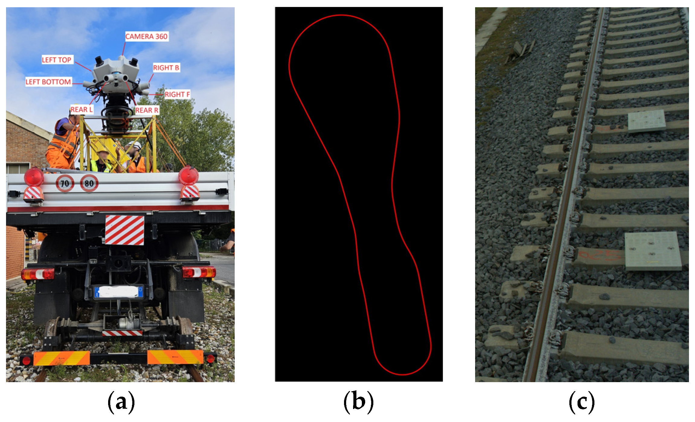
Figure 1. (a) Leica TRK700 Evo MMS mounted on a hybrid vehicle for the acquisition of the test dataset. (b) Track of the San Donato railway test circuit (Bologna, Italy), (c) image of two balises.
Proceedings 129 00039 g001
Figure 2. Block diagram of the proposed object identification procedure.
Proceedings 129 00039 g002
Figure 3. (a) Original section of a 3D point cloud (mean intensity along x), (b) same section in the new coordinate system (invertible transformation).
Proceedings 129 00039 g003
Figure 4. (a) Section of the trajectory seen from above containing two balises. (b) Transversal section containing a balise.
Proceedings 129 00039 g004
Table 1. Main performance of the MMS.
CharacteristicsValue
Absolute accuracy in [X,Y], [Z]11 mm, 11 mm (no GNSS outage),
14 mm, 16 mm (60 s GNSS outage)
Maximum pulse rate2 × 2.2 MHz
Maximum rotational speed2 × 267 Hz
Precision1 mm
Maximum range 50% reflectivity at 200 kHz/500 kHz182 m
Maximum range 10% reflectivity at 200 kHz/500 kHz182 m
Number of returns1
Minimum range0.3 m
Field-of-view360° full circle
Data acquisition rateMax. 2 × 1.094 million pixel/s.
Table 2. Performance of the three methods developed.
Detection MethodAccuracyPrecisionRecall
Section Profile0.90.9350.923
Rectangle0.8670.9860.911
Smoothness111
Disclaimer/Publisher’s Note: The statements, opinions and data contained in all publications are solely those of the individual author(s) and contributor(s) and not of MDPI and/or the editor(s). MDPI and/or the editor(s) disclaim responsibility for any injury to people or property resulting from any ideas, methods, instructions or products referred to in the content.