Behind the 3D Scene: A GIS Approach for Managing the Chronological Information of Historic Buildings


Abstract

1. Introduction
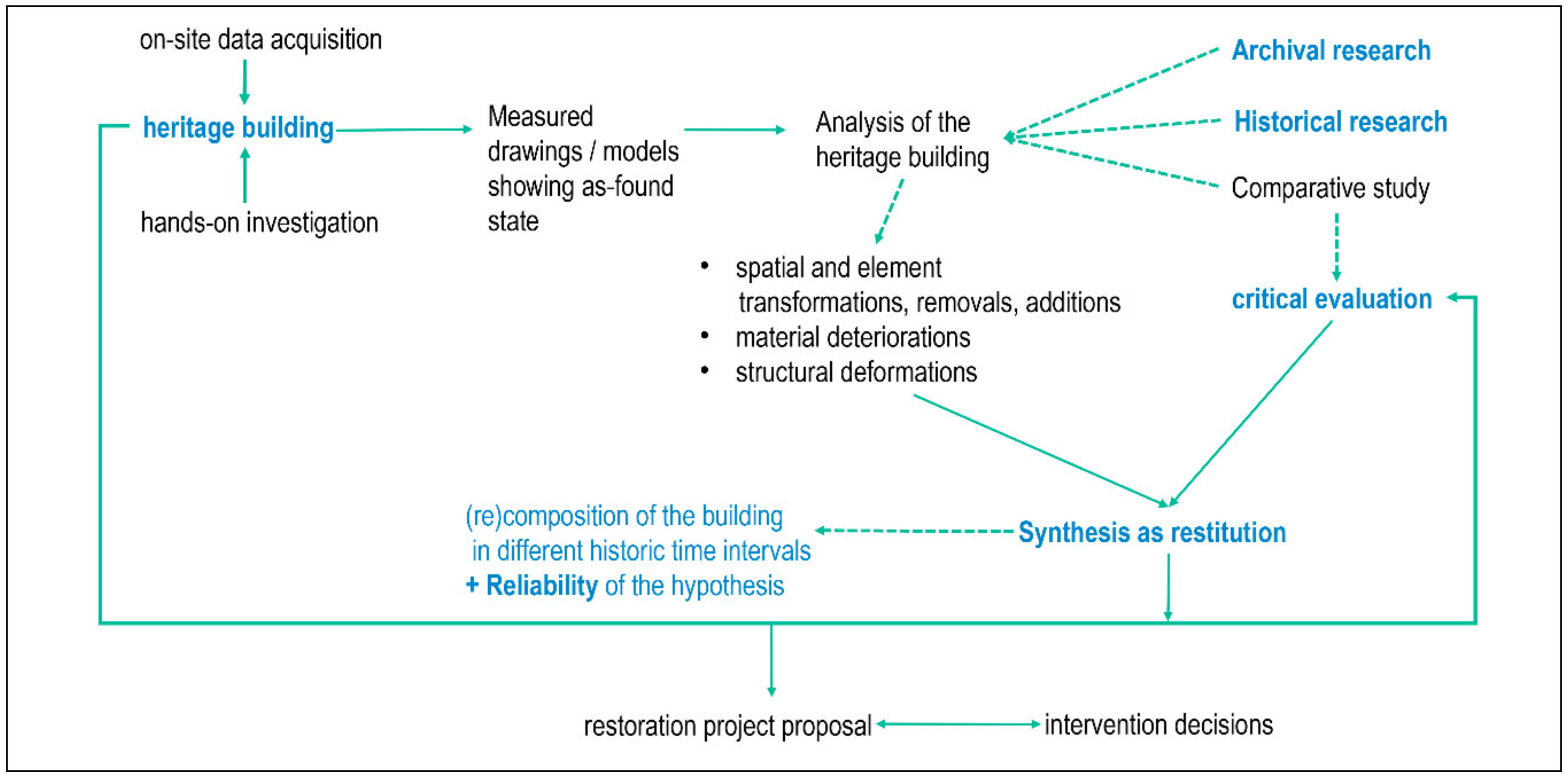
- (i)
- On-site data acquisition,
- (ii)
- Hands-on investigations of the building’s characteristics, which result in the production of measured drawings which show the as-found state of the heritage building,
- (iii)
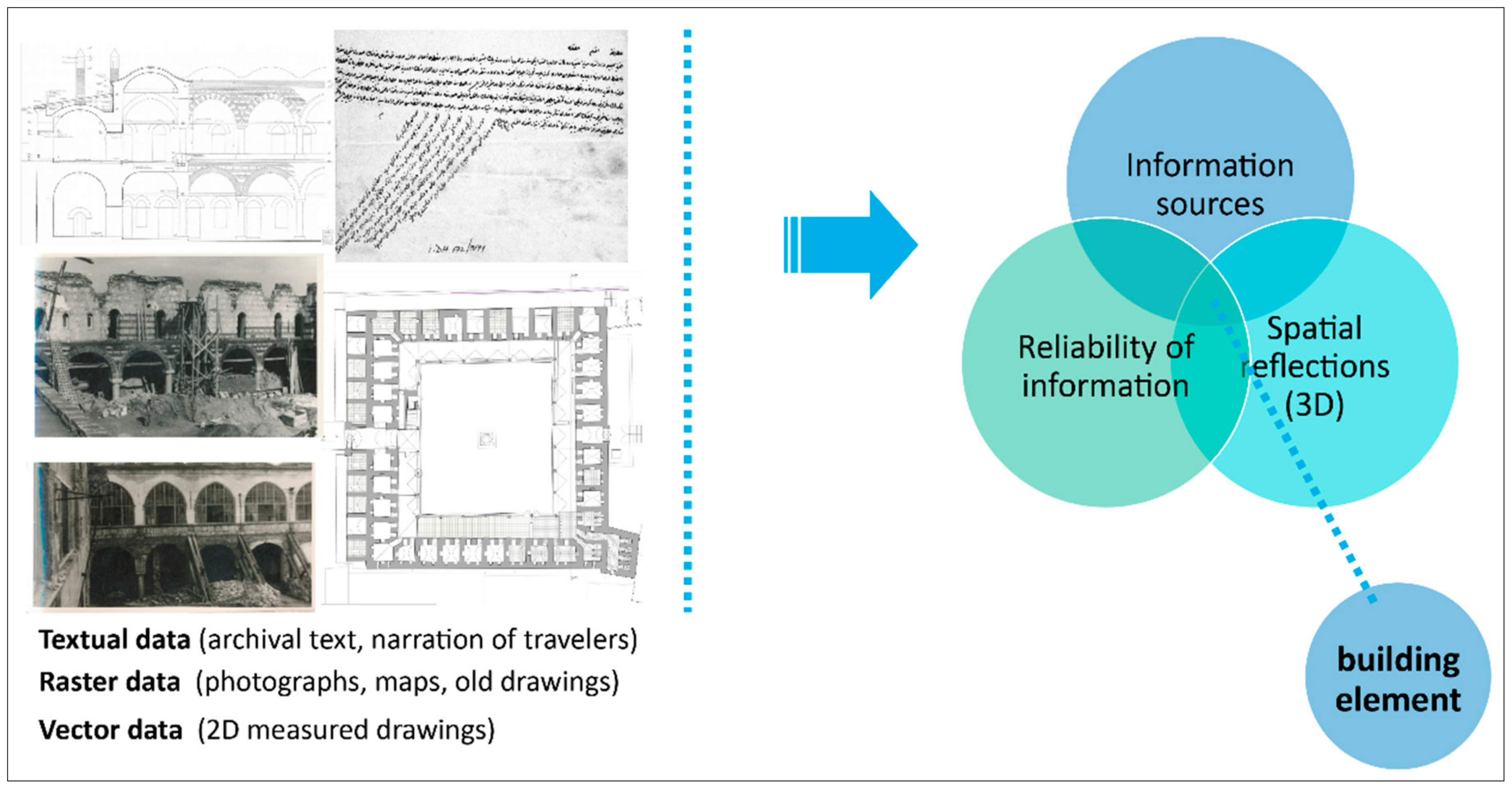
- Complementary archival and historical research, and comparative study for supporting analysis, which is a comprehensive process covering spatial and/or element alterations (transformations, removals, additions), structural failures or deformations, and material deteriorations,
- (iv)
- Synthesis for the (re)establishing of the building’s chronology in different historical time intervals, and a critical evaluation of the physical aspects and other aspects beyond those,
- (v)
- Development of intervening decisions, with regard to the proposed conservation actions.
1.1. State-of-the-Art
- -
- Level 1: basic outline as a solid object,
- -
- Level 2: outline of the building as a solid object, with the principal and generic architectural features,
- -
- Level 3: outline of the building represented as a solid object with all features, and
- -
- Level 4: the detailed survey of the building represented as a solid object, covering all architectural custom components. Nevertheless, one should select the optimum level of graphical detail sufficient for the purpose considering time, cost, and effectiveness.
1.2. Potentials and Current Limitations
1.3. Research Aim and Content
2. Materials and Methods
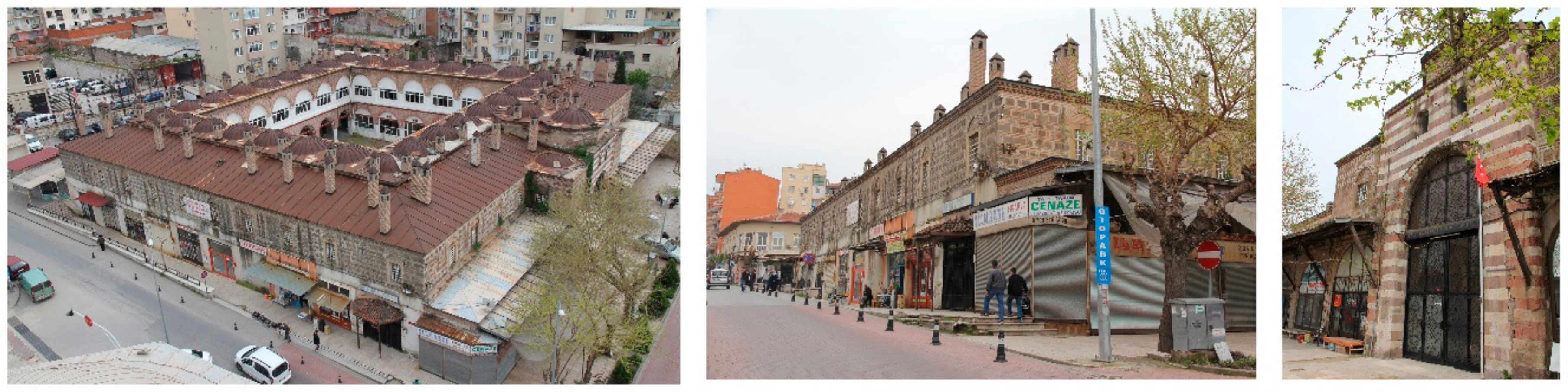
2.1. The Case Study
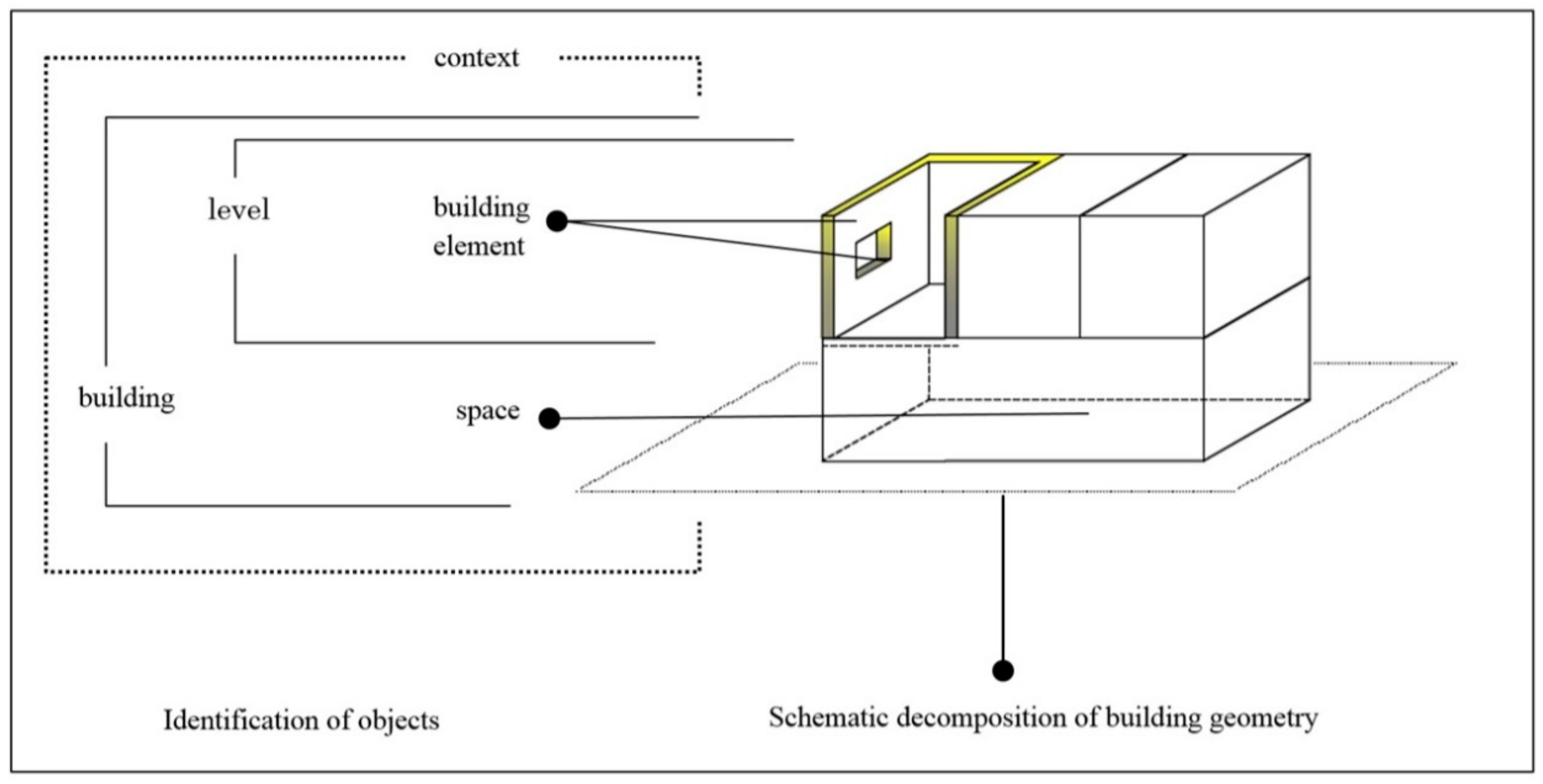
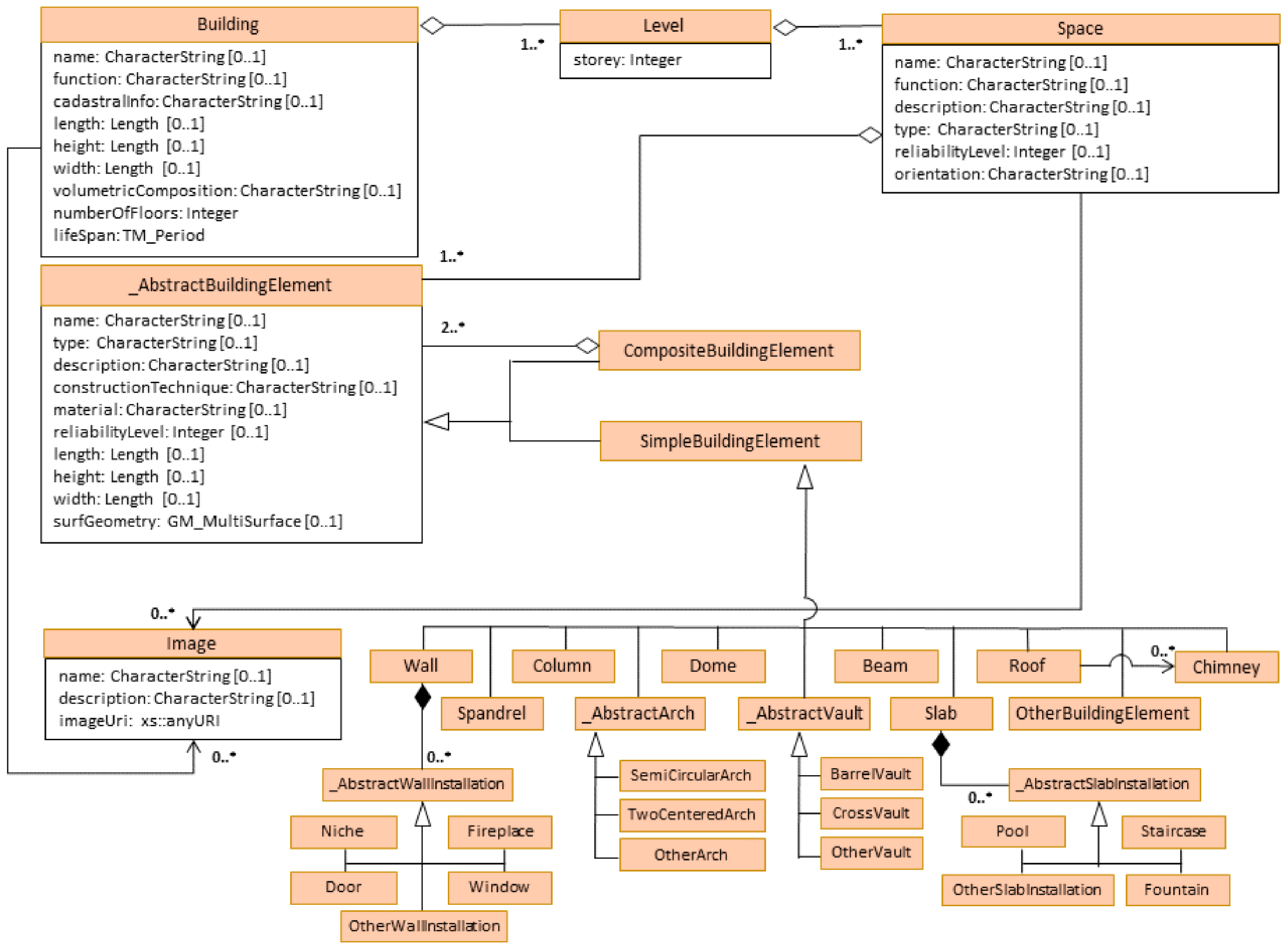
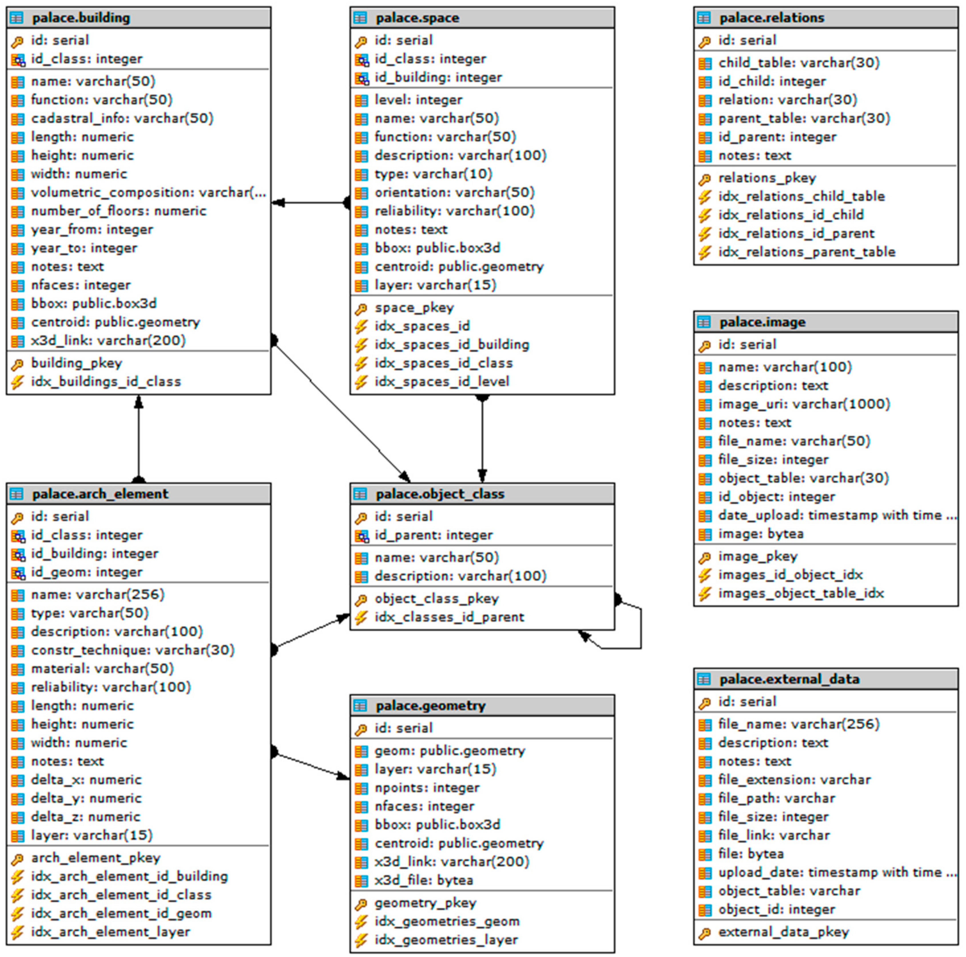
2.2. Conceptual Modeling and Design
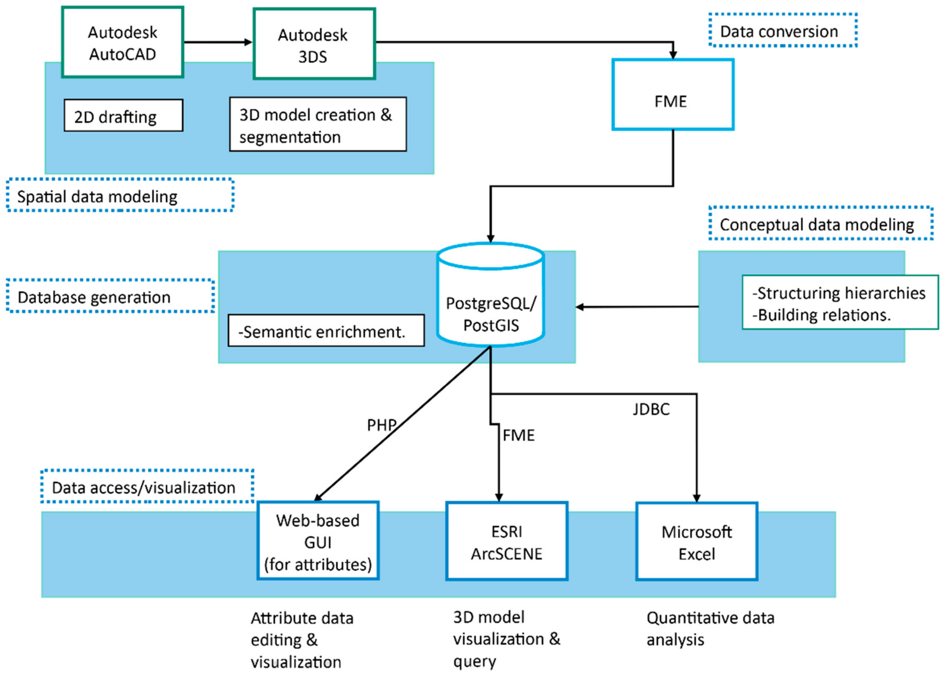
2.3. Workflow of the Process
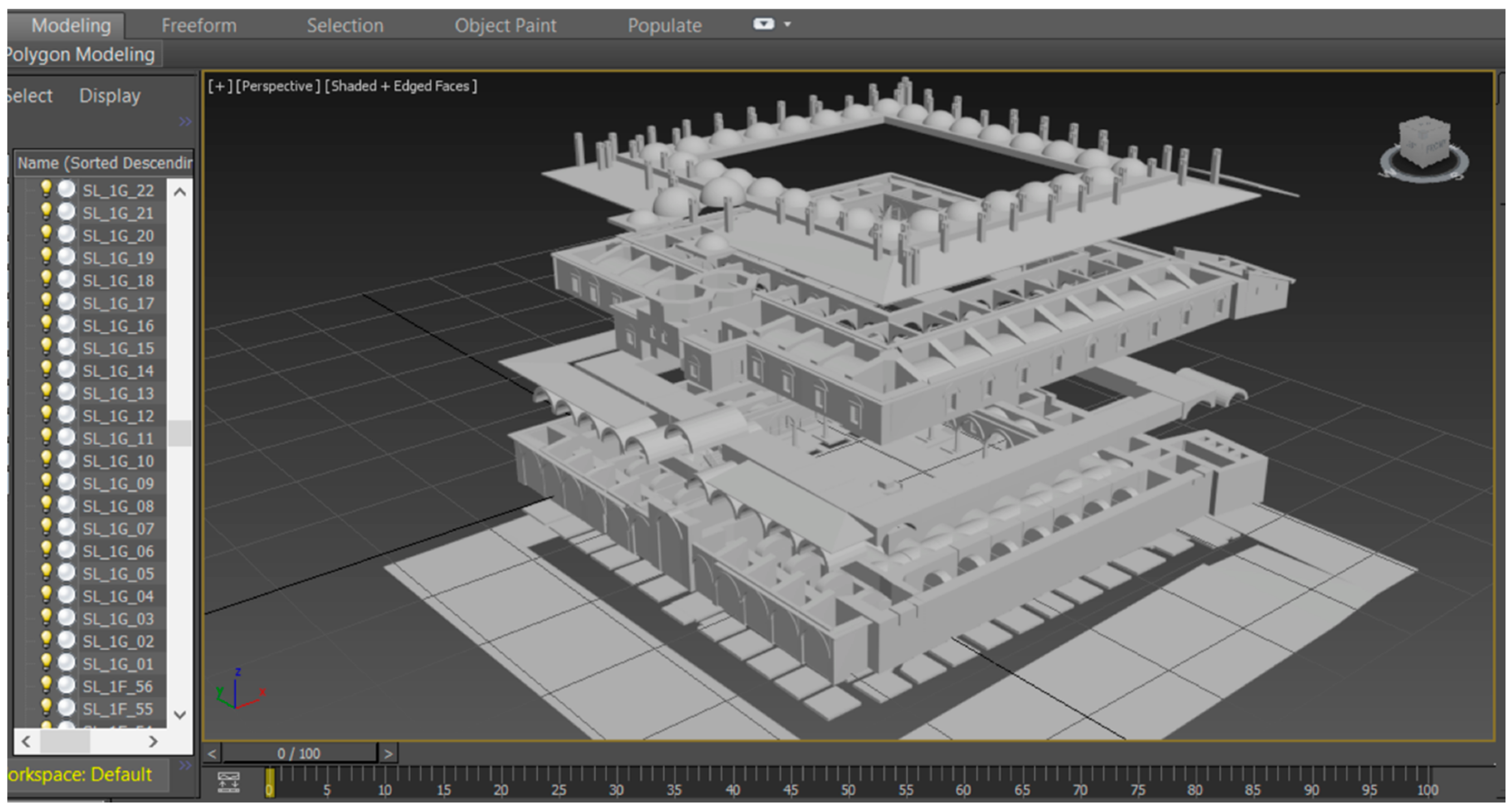
2.3.1. Preparation of the 3D Model
2.3.2. Semantic Enrichment
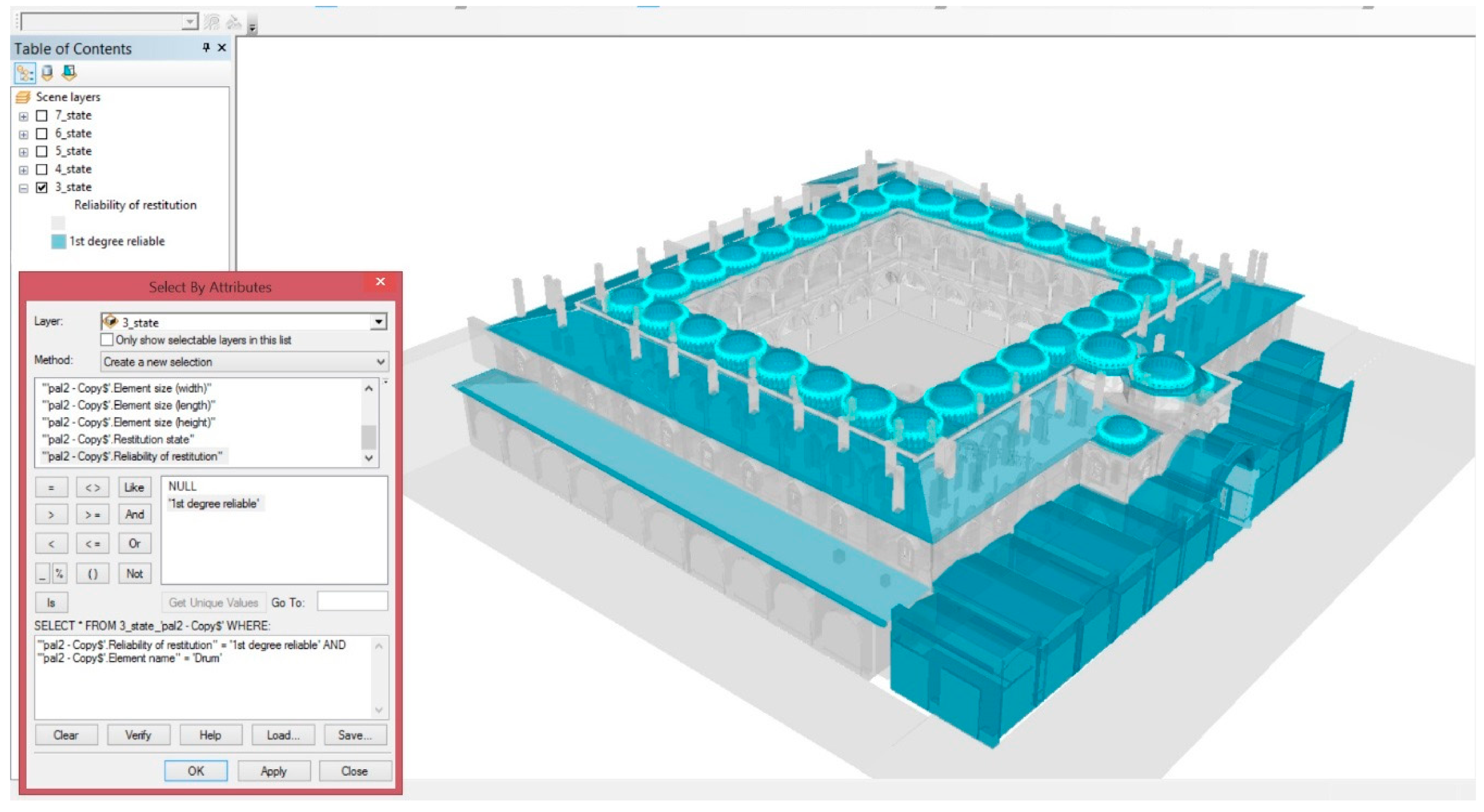
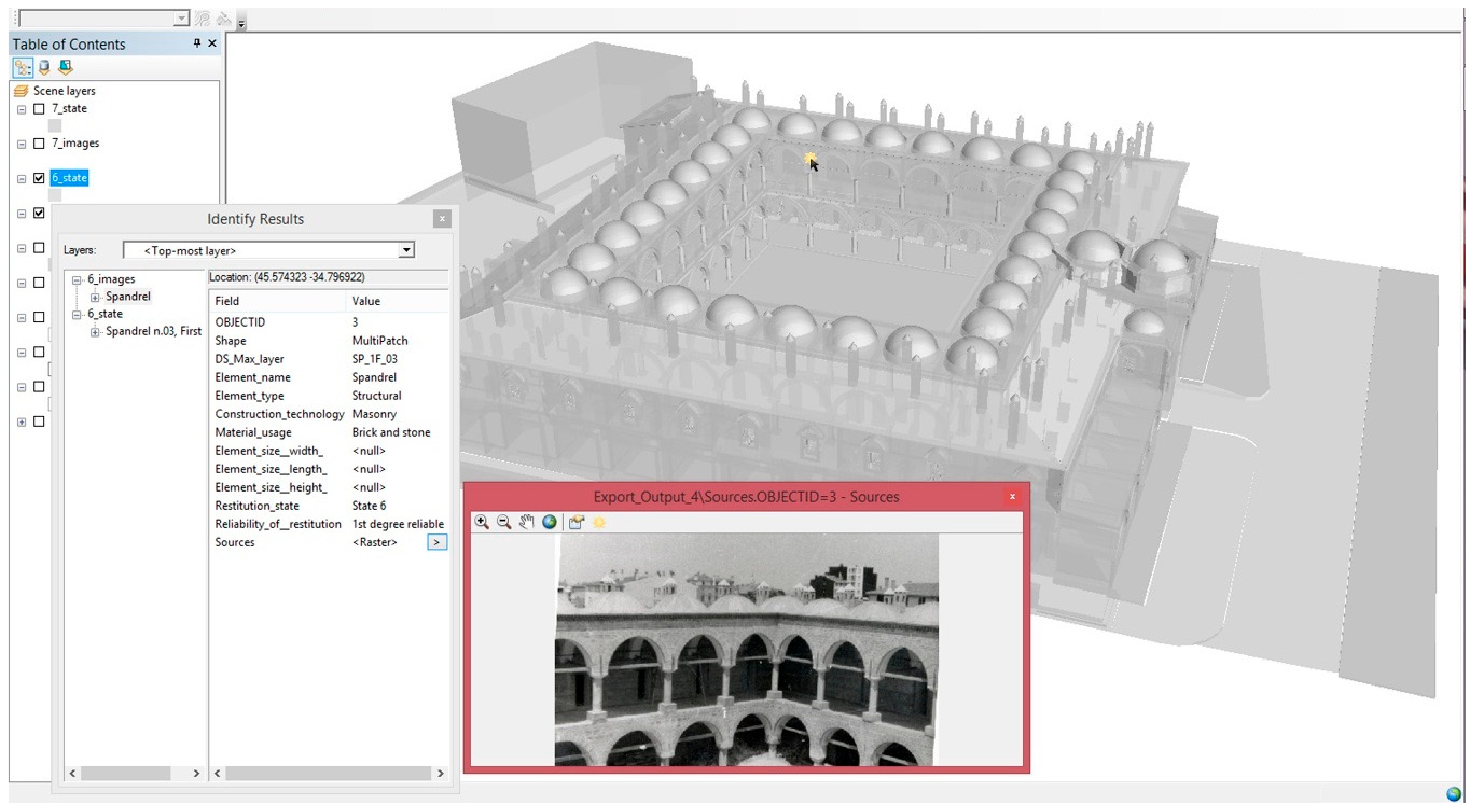
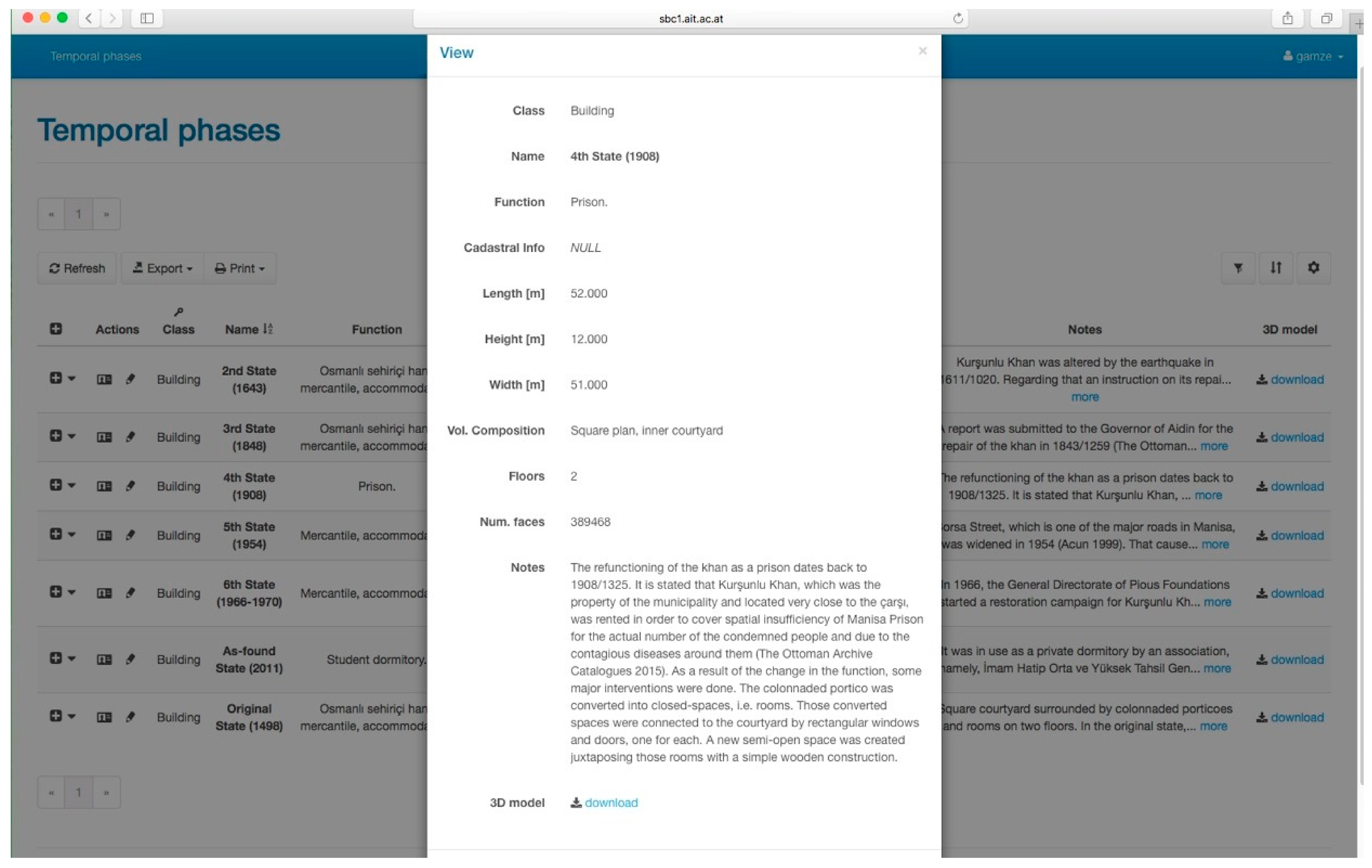
2.3.3. Data Access and Visualization Options
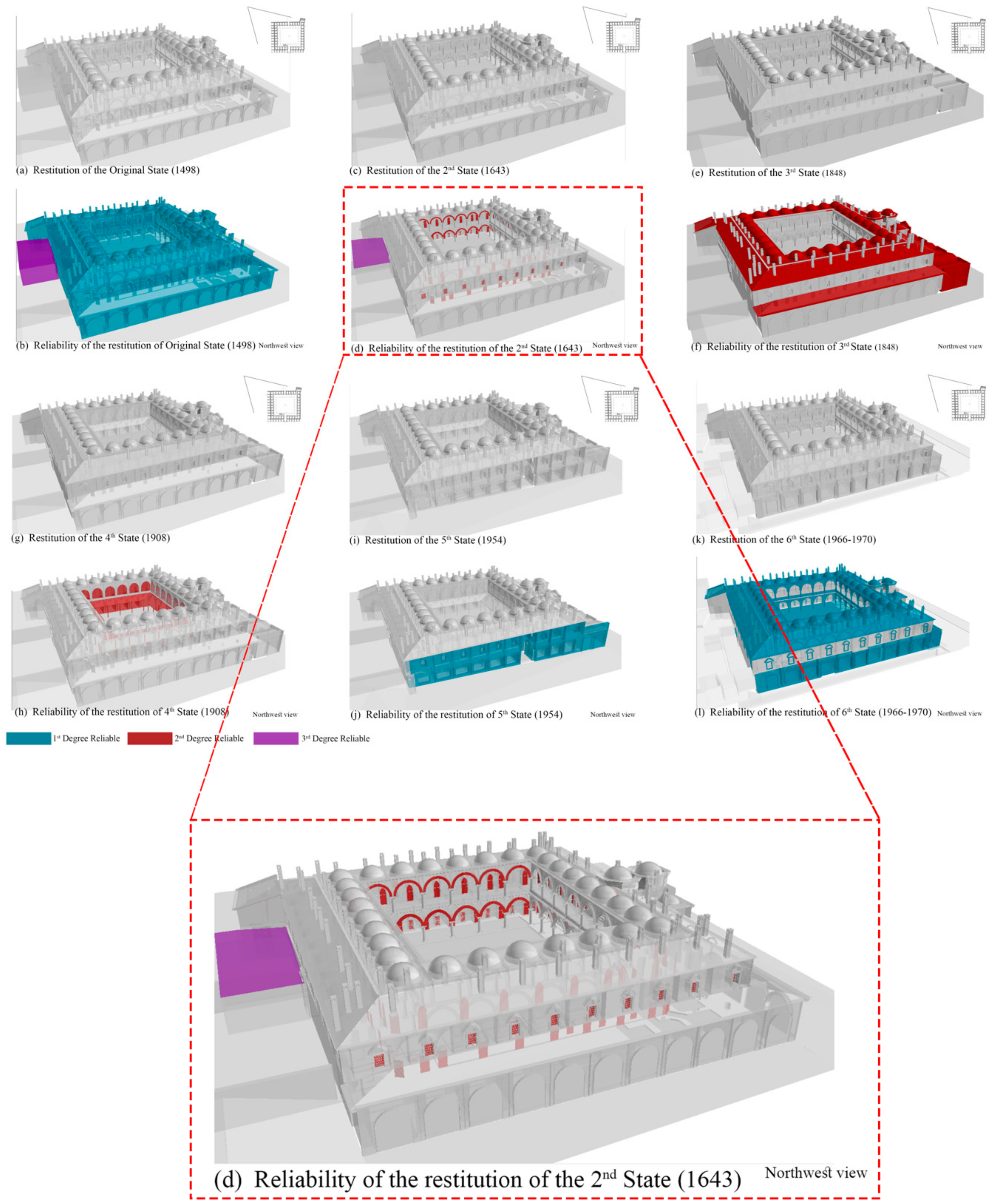
3. Results
4. Discussion
Directions for Future Studies
Author Contributions
Acknowledgments
Conflicts of Interest
References
- Letellier, R. Recording and Information Management for the Conservation of Heritage Places: Guiding Principles. Available online: http://www.getty.edu/conservation/publications_resources/pdf_publications/recordim.html (accessed on 12 April 2018).
- El-Hakim, S.; Gonzo, L.; Voltolini, F.; Girardi, S.; Rizzi, A.; Remondino, F.; Whiting, E. Detailed 3D Modelling of Castles. Int. J. Archit. Comput. 2007, 5, 199–220. [Google Scholar] [CrossRef]
- Doulamis, A.; Ioannides, M.; Doulamis, N.; Hadjiprocopis, A.; Fritsch, D.; Balet, O.; Santos, P. 4D reconstruction of the past. In Proceedings of the First International Conference on Remote Sensing and Geoinformation of Environment, Paphos, Cyprus, 5 August 2013. [Google Scholar]
- Georgopoulos, A. 3D virtual reconstruction of archaeological monuments. Mediterr. Archaeol. Archaeom. 2014, 14, 155–164. [Google Scholar]
- Canciani, M.; Falcolini, C.; Buonfiglio, M.; Pergola, S.; Saccone, M.; Mammì, B.; Van Gool, L. A method for virtual anastylosis: The case of the arch of Titus at the Circus Maximus in Rome. In Proceedings of the IEEE Computer Society Conference on Computer Vision and Pattern Recognition Workshops, Madison, WI, USA, 16–22 June 2003; pp. 2–4. [Google Scholar]
- Dudek, I.; Blaise, J.-Y. Understanding Changes in Heritage Architecture. In Proceedings of the IMAGAPP/IVAPP (International Conference on Information Visualization Theroy and Applications), Angers, France, 17–21 May 2010; pp. 91–100. [Google Scholar]
- Rodríguez-Gonzálvez, P.; Muñoz-Nieto, A.L.; DelPozo, S.; Sanchez-Aparicio, L.J.; Gonzalez-Aguilera, D.; Micoli, L.; Hejmanowska, B. 4D reconstruction and visualization of cultural heritage: Analyzing our legacy through time. Int. Arch. Photogramm. Remote Sens. Spat. Inf. Sci. 2017, 42, 609–616. [Google Scholar] [CrossRef]
- Historic England. Photogrammetric Applications for Cultural Heritage. Guidance for Good Practice; Historic England: Swindon, UK, 2017. [Google Scholar]
- AEC (UK) Committee. AEC (UK) BIM Technology Protocol, Practical Implementation of BIM for the UK Architectural, Engineering and Construction (AEC) Industry. Available online: https://aecuk.files.wordpress.com/2015/06/aecukbimtechnologyprotocol-v2-1-1-201506022.pdf (accessed on 12 April 2018).
- Andrews, D.; Bedford, J.; Bryan, P. Metric Survey Specifications for Cultural Heritage. 2015. Available online: http://archaeologydataservice.ac.uk/archiveDS/archiveDownload?t=arch-1416-1/dissemination/pdf/9781848021716.pdf (accessed on 12 April 2018).
- Saygi, G.; Agugiaro, G.; Hamamcıoğlu-Turan, M.; Remondino, F. Evaluation of Gis and Bim Roles for the Information Management of Historical Buildings. ISPRS Ann. Photogramm. Remote Sens. Spat. Inf. Sci. 2013, II-5/W1, 283–288. [Google Scholar] [CrossRef]
- Dore, C.; Murphy, M. Current State of the Art Historic Building Information Modelling. Int. Arch. Photogramm. Remote Sens. Spat. Inf. Sci. 2017, XLII-2/W5. [Google Scholar] [CrossRef]
- Historic England. BIM for Heritage; Antonopoulou, S., Cons, A., Bryan, P., Eds.; Historic England: Swindon, UK, 2017; Available online: https://content.historicengland.org.uk/images-books/publications/bim-for-heritage/heag-154-bim-for-heritage.pdf/ (accessed on 12 April 2018).
- Hichri, N.; Stefani, C.; De Luca, L.; Veron, P. Review of the “As-Built Bim” Approaches. Int. Arch. Photogramm. Remote Sens. Spat. Inf. Sci. 2013, XL-5/W1, 107–112. [Google Scholar] [CrossRef]
- Chiabrando, F.; Lo Turco, M.; Rinaudo, F. Modeling the Decay in an Hbim Starting From 3D Point Clouds. A Followed Approach for Cultural Heritage Knowledge. Int. Arch. Photogramm. Remote Sens. Spat. Inf. Sci. 2017, XLII-2/W5, 605–612. [Google Scholar] [CrossRef]
- Brumana, R.; Oreni, D.; Raimondi, A.; Georgopoulos, A.; Bregianni, A. From survey to HBIM for documentation, dissemination and management of built heritage: The case study of St. Maria in Scaria d’Intelvi. In Proceedings of the 2013 Digital Heritage International Congress (DigitalHeritage), Marseille, France, 28 October–1 November 2013; Volume 1, pp. 497–504. [Google Scholar]
- Fai, S.; Filippi, M.; Paliaga, S. Parametric modelling (BIM) for the documentation of vernacular construction methods: a BIM model for the commissariat building, Ottawa, Canada. ISPRS Ann. Photogramm. Remote Sens. Spat. Inf. Sci. 2013, II-5/W1, 115–120. [Google Scholar] [CrossRef]
- Yajing, D.; Cong, W. Research on the Building Information Model of the stone building for heritages conservation with the outer south gate of the Ta Keo Temple as an example. In Proceedings of the 2011 International Conference on Electric Technology and Civil Engineering (ICETCE), Lushan, China, 22–24 April 2011; pp. 1488–1491. [Google Scholar] [CrossRef]
- Vosselman, G.; Gorte, B.; Sithole, B.G.; Rabbani, B.T. Recognising structure in laser scanner point clouds. Inter. Arch. Photogramm. Remote Sens. Spat. Inf. Sci. 2003, 46, 33–38. [Google Scholar]
- Pu, S.; Vosselman, G. Automatic extraction of building features from terrestrial laser scanning. Int. Arch. Photogramm. 2006, 36, 25–27. [Google Scholar]
- Rusu, R.B.; Marton, Z.C.; Blodow, N.; Holzbach, A.; Beetz, M. Model-based and learned semantic object labeling in 3D point cloud maps of kitchen environments. In Proceedings of the 2009 IEEE/RSJ International Conference on Intelligent Robots and Systems, St. Louis, MO, USA, 10–15 October 2009; pp. 3601–3608. [Google Scholar] [CrossRef]
- Xiong, X.; Huber, D. Using Context to Create Semantic 3D Models of Indoor Environments. In Proceedings of the British Machine Vision Conference, Wales, UK, 31 August–3 September 2010; p. 45. [Google Scholar] [CrossRef]
- Yue, K.; Huber, D.; Akinci, B.; Krishnamurti, R. The ASDMCon project: The challenge of detecting defects on construction sites. In Proceedings of the 3D Data Processing, Visualization, and Transmission, Third International Symposium, Chapel Hill, NC, USA, 14–16 June 2006; pp. 1048–1055. [Google Scholar] [CrossRef]
- Ben Hmida, H.; Cruz, C. From 3D Point Clouds to Semantic Objects—An Ontology-based Detection Approach. In Proceedings of the International Conference on Knowledge Engineering and Ontology Development, Paris, France, 26–29 October 2011; pp. 255–260. [Google Scholar]
- Saygi, G.; Remondino, F. Management of Architectural Heritage Information in BIM and GIS: State-of-the-Art and Future Perspectives. Int. J. Heritage Digit. Era 2013, 2, 695–713. [Google Scholar] [CrossRef]
- Centofanti, M.; Continenza, R.; Brusaporci, S.; Trizio, I. the Architectural Information System Siarch3D-Univaq for Analysis and Preservation of Architectural Heritage. Int. Arch. Photogramm. Remote Sens. Spat. Inf. Sci. 2012, 5, 9–14. [Google Scholar] [CrossRef]
- SanJosé-Alonso, J.; Finat, J. Information and knowledge systems for integrated models in Cultural Heritage. ISPRS Arch. Photogramm. Remote Sens. Spat. Inf. Sci. 2009, 38. Available online: http://citeseerx.ist.psu.edu/viewdoc/download?doi=10.1.1.445.2498&rep=rep1&type=pdf (accessed on 12 April 2018).
- ICOMOS. Charter for the Interpretation and Presentation of Cultural Heritage. 2008. Available online: https://www.icomos.org/charters/interpretation_e.pdf (accessed on 12 April 2018).
- Koller, D.; Frischer, B.; Humphreys, G. Research challenges for digital archives of 3D cultural heritage models. J. Comput. Cult. Heritage 2009, 2, 1–17. [Google Scholar] [CrossRef]
- Brusaporci, S. The Importance of Being Honest: Issues of Transparency in Digital Visualization of Architectural Heritage. In Handbook of Research on Emerging Technologies for Architectural and Archaeological Heritage; IGI Global: Hershey, PA, USA, 2017. [Google Scholar]
- Apollonio, F.I.; Gaiani, M.; Sun, Z. 3D Modeling and Data Enrichment in Digital Reconstruction of Architectural Heritage. Int. Arch. Photogramm. Remote Sens. Spat. Inf. Sci. 2013, XL-5/W2, 43–48. [Google Scholar] [CrossRef]
- Garagnani, S.; Manferdini, A.M. Parametric accuracy: Building information modeling process applied to the cultural heritage preservation. Int. Arch. Photogramm. Remote Sens. Spat. Inf. Sci. 2013, XL-5/W1, 87–92. [Google Scholar] [CrossRef]
- Kolbe, T.H.; Gröger, G.; Plümer, L. CityGML–3D City Models and their Potential for Emergency Response. Available online: https://www.researchgate.net/publication/254899282_Bimserverorg_-_an_Open_Source_IFC_model_server (accessed on 12 April 2018).
- Beetz, J.; van Berlo, L.; de Laat, R.; van den Helm, P. bimserver.org—An Open Source IFC Model Server. In Proceedings of the CIB W78 2010: 27th International Conference, Cairo, Egypt, 16–18 November 2010; pp. 16–18. Available online: http://bimserver.org/wp-content/uploads/2010/11/Beetz_Berlo-CIB-W78_Cairo.pdf (accessed on 12 April 2018).
- BuildingSMART. 2018. Available online: http://www.buildingsmart-tech.org/ (accessed on 12 April 2018).
- Ma, Z.; Ren, Y. Integrated Application of BIM and GIS: An Overview. Procedia Eng. 2017, 196, 1072–1079. [Google Scholar] [CrossRef]
- Alp, S.Ç.; Güçhan, N.Ş. Challenges in use of geographical information systems (GIS) in a research for understanding conservation of cultural heritage in Bursa. J. Cult. Heritage Manag. Sustain. Dev. 2017, 7, 328–344. [Google Scholar] [CrossRef]
- Baik, A.; Yaagoubi, R.; Boehm, J. Integration of jeddah historical bim and 3D GIS for documentation and restoration of historical monument. Int. Arch. Photogramm. Remote Sens. Spat. Inf. Sci. 2015, XL-5/W7, 29–34. [Google Scholar] [CrossRef]
- Güran, C. Türk Hanlarının Gelişimi ve İstanbul Hanları Mimarisi; Vakıflar Genel Müdürlüğü Yayınları. 1976. Available online: https://books.google.fr/books?id=8tnTnQEACAAJ (accessed on 12 April 2018).
- UNESCO. Universal Declaration on Cultural Diversity; Stenou, K., Ed.; United Nations Educational, Scientific and Cultural Organization: Paris, France, 2002; Available online: http://scholar.google.com/scholar?hl=en&btnG=Search&q=intitle:Universal+Declaration+on+Cultural+Diversity#3 (accessed on 12 April 2018).
- Brandi, C.; Basile, G. Theory of Restoration; Istituto Centrale per il Restauro: Roma/Firenze, Italy, 2005. [Google Scholar]
- ARK Insaat. Kurşunlu Han Rölöve, Restitüsyon; Restorasyon Projesi; ARK Insaat: Ankara, Turkey, 2011. [Google Scholar]
- Agugiaro, G.; Remondino, F.; Girardi, G.; Von Schwerin, J.; Richards-Rissetto, H.; De Amicis, R. QueryArch3D: Querying and Visualising 3D Models of a Maya Archaeological Site in a Web-Based Interface. Geoinform. FCE CTU 2011, 6, 10–17. [Google Scholar] [CrossRef][Green Version]
- Von Schwerin, J.; Richards-Rissetto, H.; Remondino, F.; Agugiaro, G.; Girardi, G. The mayaarch3d project: A 3D webgis for analyzing ancient architecture and landscapes. Lit. Linguist. Comput. 2013, 28, 736–753. [Google Scholar] [CrossRef]
- Von Meiss, P. Elements of Architecture: From Form to Place; Routledge: Abingdon-on-Thames, UK, 2011. [Google Scholar]
- Booch, G.; Rumbaugh, J.; Jacobson, I. The Unified Modeling Language User Guide. Techniques; 1998; Volume 3. Available online: http://portal.acm.org/citation.cfm?id=1088874 (accessed on 12 April 2018).
- The PostgreSQL Global Development Group. PostgreSQL 10.3 Documentation. 2018. Available online: https://www.postgresql.org/docs/10/static/index.html (accessed on 12 April 2018).
- Obe, R.; Hsu, L. PostGIS in Action. Manning. 2011. Available online: https://books.google.fr/books?id=4kEBRQAACAAJ (accessed on 12 April 2018).
- Or, S.-H.; Wong, K.; Yu, Y.-K.; Chang, M.; Kong, H.; Highly Automatic Approach to Architectural Floorplan Image Understanding & Model Generation. Pattern Recognit. 2005, 25–32. Available online: http://www.cse.cuhk.edu.hk/~shor/project/building/vmv05.pdf (accessed on 12 April 2018).
- Moloo, R.K.; Dawood, M.A.S.; Auleear, A.S. 3-Phase Recognation Approach to Pseudo 3D Building Generation from 2D Floor Plan. Int. J. Comput. Graph. Anim. 2011, 1, 13–27. [Google Scholar] [CrossRef]
- Lewis, R.; Sequin, C. Generation of 3D building models from 2D architectural plans. Comput.-Aided Des. 1998, 30, 765–779. [Google Scholar] [CrossRef]
- Gimenez, L.; Hippolyte, J.-L.; Robert, S.; Suard, F.; Zreik, K. reconstruction of 3D building information models from 2D scanned plans. J. Build. Eng. 2015, 2, 24–35. [Google Scholar] [CrossRef]
- Safe Software Inc. FME® Desktop Training Manual. 2015. Available online: http://docs.safe.com/fme_training/2015/pdf/FME_Desktop_Training_Manual.pdf (accessed on 12 April 2018).
- Cignoni, P.; Cignoni, P.; Callieri, M.; Callieri, M.; Corsini, M.; Corsini, M.; Ranzuglia, G. MeshLab: An Open-Source Mesh Processing Tool. In Proceedings of the Sixth Eurographics Italian Chapter Conference, Salerno, Italy, 2–4 July 2008; pp. 129–136. [Google Scholar]
- ICOMOS. Principles for the Recording of Monuments, Groups of Buildings and Sites. 1996. Available online: https://www.icomos.org/charters/archives-e.pdf (accessed on 12 April 2018).


© 2018 by the authors. Licensee MDPI, Basel, Switzerland. This article is an open access article distributed under the terms and conditions of the Creative Commons Attribution (CC BY) license (http://creativecommons.org/licenses/by/4.0/).
Share and Cite
Saygi, G.; Agugiaro, G.; Hamamcioglu-Turan, M. Behind the 3D Scene: A GIS Approach for Managing the Chronological Information of Historic Buildings. Multimodal Technol. Interact. 2018, 2, 26. https://doi.org/10.3390/mti2020026
Saygi G, Agugiaro G, Hamamcioglu-Turan M. Behind the 3D Scene: A GIS Approach for Managing the Chronological Information of Historic Buildings. Multimodal Technologies and Interaction. 2018; 2(2):26. https://doi.org/10.3390/mti2020026
Chicago/Turabian StyleSaygi, Gamze, Giorgio Agugiaro, and Mine Hamamcioglu-Turan. 2018. "Behind the 3D Scene: A GIS Approach for Managing the Chronological Information of Historic Buildings" Multimodal Technologies and Interaction 2, no. 2: 26. https://doi.org/10.3390/mti2020026
APA StyleSaygi, G., Agugiaro, G., & Hamamcioglu-Turan, M. (2018). Behind the 3D Scene: A GIS Approach for Managing the Chronological Information of Historic Buildings. Multimodal Technologies and Interaction, 2(2), 26. https://doi.org/10.3390/mti2020026