Abstract
This paper examines a 12th-century Virupaksha temple through the reconstruction and exploration of space, movement, devotee corporeal experiences, and the use of natural landscape microtopographic features in monument design. The Mula Virupaksha Temple presents a dramatic change in the previously non-imperial sacred landscape in the Hemakuta Hill area at Hampi (Bellary District, Karnataka). With its construction, Hampi transitioned from a local Shaiva pilgrimage center dedicated to the river goddess Pampa and her counterpart Bhairava to a popular Shaiva pilgrimage and cult center of the newly imported god, Virupaksha. The Mula Virupaksha Temple presents a design thoroughly novel to the area that ushered in a period of sophisticated and unprecedented architectural planning at the site which incorporated natural landscape features for the management and cultivation of devotee ritual corporeal experiences. Virupaksha, his patrons, and associated artisans brought significant cultic change and architectural innovation that took root and persisted into the imperial Vijayanagara period, from the mid-14th to late 16th centuries. The present paper relies on a digital methodology developed to identify ritual changes in early medieval South Asian sacred spaces, focusing on time-sensitive maps created through a geographic information system (GIS), and coupled with the immersive panoramic capabilities of Google Street View (GSV) for a ground-based investigation of the non-ephemeral pilgrimage landscape features.
1. Introduction
The earliest stone temples of the greater Hampi area, in the Bellary District of Karnataka, India, reside on the Tungabhadra River’s northern bank, on the granitic slopes of the Hemakuta Hill (Figure 1). These early medieval Shaiva temples date back to the 9th century, growing in number over the next five centuries into a ritually complex sacred landscape. Later temple complexes built in the Hampi area during the architectural innovation and construction heyday of the Vijayanagara Empire, from approximately the 14th through 16th centuries, as well as the wealth of inscriptions generated by the empire, dwarf the evidence available for earlier periods. As a result, the greater Hampi area’s historical significance is generally attributed to the imperial period, and its early medieval history has remained understudied—both historically and as a built landscape. Moreover, the landscape of the greater Hampi area has commonly been treated in modern scholarship as a relatively homogenous antecedent to the imperial period (Malville and Fritz 1996; Verghese 2000). This article, employing a digital methodology, contradicts this notion of a rather homogenous antecedent to the imperial period and analyzes a major cultic and ritual shift in the religious landscape of the Hampi area prior to the establishment of the Vijayanagara Empire in c. 1336. By analyzing the construction and spatial details of a 12th-century Virupaksha temple in the Hemakuta Hill sacred space, a site for pilgrimage since at least the 7th century, I argue that the religious history of the greater Hampi area was diverse and more complex than it has generally been portrayed in contemporary scholarly works. Although this article focuses on the material culture of the Hemakuta Hill area and Shaiva pilgrimage traditions, they did not exist and develop in a vacuum. Other religions, such as Jainism and Buddhism, were also influential in the surrounding regions during this and the proceeding Vijayanagara imperial period.
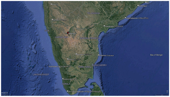
Figure 1.
Modern state boundaries and capital cities of South India plus the location of Hampi and the Hemakuta Hill area, in the state of Karnataka. Imagery from Google Earth.
Supplementing the limited textual primary sources and in order to shed light on the complex history predating the Vijayanagara imperial period, the sacred landscape, both natural and built features, has been digitized, using a geographic information system (GIS). The movement and sensorial experience of a devotee moving through this space was then investigated through the immersive panoramic capabilities of Google Street View (GSV) for ground-based investigation of non-ephemeral pilgrimage landscape features. This methodology has been permitted for the creation and exploration of time-sensitive landscape maps of the Hemakuta Hill area throughout the early medieval period, in which ritual and cultic changes are perceptible. This paper, however, focuses on the analysis of a major cultic change that began in the 12th century that laid the foundations for later imperial adoption of the site as a significant religious center. Ephemeral structures such as dwellings, shops, and stalls have not been identified for this research. Recognizing that these structures would have influenced a pilgrim’s experience, they would not alter the findings of this study.
The GIS and GSV tools that I utilized for this article allow researchers to examine cues in structural-spatial ordering to identify choices in the development of architectural forms over time and the inter-relationships of particular forms with the surrounding landscape. Using this method, one can assess visual and physical alignments between objects and from subjects to objects without prioritizing an analytical focus on viewsheds, as is common in GIS-based archaeological research. By analytically emphasizing the visual relationship between two points in space, the visual accessibility between subjects and/or objects, and the process of a body worshipping and moving through space, the concept of darshan and Bell’s “ritual body” can further inform this methodology (Bell 2009, pp. 81–82).
The Mula Virupaksha Temple, built in the 12th century with the austere architectural Phamsana language, represented a thoroughly novel design for Hampi and ushered in a period of sophisticated and unprecedented architectural planning that incorporated natural landscape features. The sophisticated incorporation of microtopographic elements for the temple’s construction in this sacred space provided patrons the opportunity to manage and cultivate particular ritual corporeal experiences for the devotees visiting the site. Through the use of terrain and structural alignments to sacred symbols within the Hemakuta Hill area, the Virupaksha cult and his temple were naturalized in an already long-established sacred space. Prior to the Virupaksha cult’s introduction to the Hampi pilgrimage space, however, temple and shrine architecture and spatial planning concerns were limited to a structure’s physical and visual accessibility to other buildings and the river, or lack thereof. The dramatic material and religious changes that the Mula Virupaksha Temple brought about in this landscape, which are analyzed below, lasted into the imperial period, signaling the pilgrimage site’s transition to a religious center of increasing ritual and political complexity, manifested in architecture and the use of sacred space.
The earliest epigraphic evidence for the religious life in the Hemakuta Hill area, dating back to 689–690, establishes that the site was an early tantric Shaiva River pilgrimage (tirtha) associated with death and salvation through its connection to the local river goddess, Pampa. As was typical in the medieval tantric tradition, the goddess Pampa was paired with a bhairava, a fierce type of deities that are often guardians, the most famous of which is Kala Bhairava from Kashi (“the Black Terror”), who took on the duties of the god of Death (Hiltebeitel 1989; Kramrisch 1994). Both deities, Pampa and Bhairava, had their own powerful soteriological properties similar to much older pilgrimage sites, such as Kashi, where devotees believed liberation from the cycle of rebirth (samsara) was possible. Together, Pampa and Bhairava provided their tirtha with the same corporeal and soteriological death-related services in Hampi as a Kashi of the south.
2. Pre-12th-Century Hemakuta Hill Sacred Space
The Hemakuta Hill on the Deccan Plateau, measures approximately 300 m long from north to south and is 150 m wide (see Figure 2). The hill itself is a pre-Cambrian granitic outcrop that has very little to no sediment deposition and has shallow undulations, creating natural paths of movement across its face. There are granitic boulders clustered into a mound on the eastern edge of the hill. Altogether, its granitic face creates a setting characterized by a range of granite microtopographic features. The hill transitions, almost seamlessly, into a vegetated terrain with soil accumulation and a large temple water tank, known as the Manmatha Tank, which was likely a natural spring. There is a cluster of shrines and small temples grouped to the west of the Manmatha Tank. The area of vegetation at the north foot of the hill connects to the Tungabhadra River 200 m to the north.
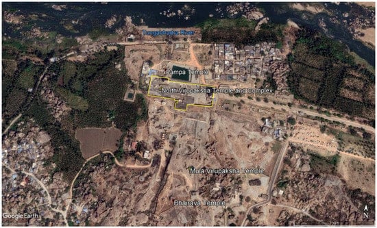
Figure 2.
Google Earth Satellite imagery of the Hemakuta Hill area with major early medieval temples identified.
The primary and normative axis of movement that devotees used to traverse the granite shelf of the Hemakuta Hill is mapped out in Figure 3, running from the south end of the hill towards the Tungabhadra River to the north. The placement of shrines and temples as well as the addition of gateways in the 7th through 13th centuries gradually accentuated the natural route navigating boulders and granitic features. A depression at the hill’s summit, concealed by the gentle hill crest surrounding it, was the southernmost space of the hill used during the early medieval period. The south side of the hill contains large, irregularly-spaced boulders and uneven granitic outcrops across a gentle slope and was not developed during the period of this research. A southern entry route to the apex of the hill is difficult to determine as the Sangama dynasty of Vijayanagara rulers (c. 1336–1485) built an enclosure wall around the then-extant monuments (Michell et al. 2001, p. 153), which still stands and obstructs the identification of a possible route. The slope on the west side of the Hemakuta Hill is abrupt and steep, making a western route up the hill an unlikely path, and was also left undeveloped. The hill’s summit is best accessed via its east side. The east side of the hill is composed of granitic boulder clusters through which there is a natural path around the south end of a boulder mound, located on the south end of the east side, leading to the crest of the hill. Overall, the Hemakuta Hill area is characterized by its range of unique microtopographic features that form physically and visually distinct areas. However, they are unified through natural pathways linking the monuments from the south to the north, along which devotees processed.
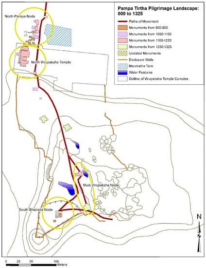
Figure 3.
Digitized site plan of the Hemakuta Hill area, including monuments, topographic, and microtopographic features, plus paths of movement from the 800 to 1325. Made using Esri’s ArcMap program.
Ritual activity in the Hemakuta Hill area prior to the foundation of the Vijayanagara Empire (c. 1336) can be divided into four periods based on observable spatial-architectural developments, cultic changes, and patterns of patronage: 800–900, 1050–1100, 1100–1250, and 1250–1325 (Haak 2018; Wagoner 1996). Architectural and epigraphic evidence consisting of extant religious monuments and auxiliary structures, as well as nine inscriptions, have allowed scholars to trace the development of the sacred space in the Hemakuta Hill area. Analyses of these two types of evidence supplemented by digital tools expose groups and even individuals, investing in the maintenance and development of the site (Haak 2022).
The stone monuments of the Hampi area from the 9th to the 13th centuries developed on and at the northern foothill of the sacred Hemakuta Hill. There are 28 extant monuments including shrines, temples, gateways, and several auxiliary temple structures, such as an ambulatory and a feeding house for brahmins from this period, all of which have been archaeologically identified and recorded by the Vijayanagara Research Project (VRP). Of these structures, there are approximately 22 temples and shrines, 15 are located at the northern foot of the hill and seven on the hill itself (Haak 2018, pp. 113–20). In addition to the construction of new monuments, an important part of the development of the Hemakuta Hill sacred space was the renovation of existing shrines and temples. Renovation activity occurred through the early medieval period, typically by expanding a shrine (vimana) that consisted of a garbhagriha (sanctum sanctorum that houses a deity) and an antarala (antechamber) or small porch, into a temple (consisting of a vimana and mandapa [pillared hall]), or through the addition of auxiliary architectural elements onto or in relation to the religious monument. The latter is the case for the Mula Virupaksha Temple which was renovated through the addition of a freestanding monolithic stone gateway during the final period of this research, 1250–1325.
The ritual change discussed here began in the period between 1100 and 1250, in which only four extant temples and shrines plus five auxiliary structures were built. From 800 to 1100, 15 temples and shrines of small scale were constructed. Of those, nine are from 800 to 900, and five from 1050 to 1100. Following the aforementioned period of cultic and ritual change, from 1250 to 1325, we see the construction of even fewer structures, though on a larger scale and with increasing architectural sophistication. These included three temples and one auxiliary structure. Thus, over time and most evident in the period of 1100–1250, the earlier trend of erecting a larger number of small shrines left its place to fewer but bigger and more complex temples in the sacred Hemakuta Hill space.
The earliest architectural evidence of the pilgrimage site for the river goddess Pampa (Pampa tirtha or Pampakshetra) during the early medieval period began with the construction of nine stone religious monuments in the period of 800–900. Seven of them were at the northern foot of the hill and on the west side of the south-north path of movement leading through the site to the Tungabhadra River. Within this group are the Pampa Shrine and six memorial shrines. Together they establish the northernmost group of monuments of the pilgrimage space (the north Pampa node). The memorial shrines were part of a broader cult of ancestors (Bakker 2007) based primarily on their use of the austere Phamsana architectural language (easily identifiable through the use of a low, stepped pyramidal superstructure over the garbhagriha (Meister 1976). This was a tradition corroborated through limited inscriptional evidence associated with Phamsana temples, discussed further below, and documented by Wagoner at the South Indian site of Telangana (Wagoner 1986; Wagoner 1996; Haak 2018). Two shrines, including the Bhairava Shrine, were established at the apex of the hill within a microtopographic depression (the south Bhairava node). They established the southernmost group of monuments of the south-north axis organizing the site.
The positioning of the memorial shrines devoted to ancestor worship in the north Pampa node suggests an interest in proximity to Pampa and her powers of salvation as a river goddess, in addition to the purifying abilities of the nearby river and the auspiciousness of north as a cardinal direction, as opposed to the south Bhairava node. During this early period, the two nodes of monuments, south and north, defined the primary axis of the spatial organization in the Hemakuta Hill area and by extension, the movement of the devotees in the sacred space that linked nodes. This axis persisted until the 12th-century addition of two Virupaksha temples, including the Mula Virupaksha Temple, creating an increasingly complex network of nodes that intervene and branch out from the south-north axis.
In the subsequent period of 1050 to 1100, no new Phamsana memorial shrines were built. Instead, three temples and three shrines, using the more ornate architectural styles of Dravida and Proto-Vesara, were established. Furthermore, the Pampa and Bhairava shrines were renovated into a temple form (along with the Naganandeshvara Temple) with the addition of a mandapa (pillared hall). Of the three new shrines, two were built on the north-facing slope of the Hemakuta Hill. The remainder of the new monuments were established in the north Pampa node (Haak 2018, 2022).
Extant textual evidence from the early medieval period in the Hampi area comes from epigraphical sources, in particular, religious donative inscriptions. They were primarily written in Kannada and inscribed on stone slabs. Their content includes the date the donation was made, the donor’s identity, the nature of the donation contents, and the deity to whom the donation was made. If applicable, they also mentioned the donor’s ruler. Together, the pre-12th century epigraphic evidence and monuments establish the Hampi area as a pilgrimage space with salvific properties through the grace of Pampa.
An inscription located at Togurshode (Kurnool District, Andhra Pradesh), dated to 689–690, is the earliest record referring to the Pampa tirtha (Wagoner 1996). It mentions “the Pampa tirtha” in the context of a religious donation made to a Vedic scholar on behalf of an Early Chalukya king after a successful military campaign (Burgess 1877, pp. 85–88). Likewise, two later inscriptions from 1014 and 1018 commemorate visits and donations made by Nolamba chiefs to the Pampa tirtha after military campaigns for their fallen soldiers, suggesting that they were performing rituals for the dead (SII 1939, pp. 10–12; Wagoner 1996, p. 153). Their investment in the Hemakuta Hill area’s sacred space was limited to their visits, facilitated by the convenience of being in the vicinity while on campaigns, as evidenced by the decisions to erect their associated donative inscriptions in locations of greater political importance to each donor so that the recognition of their munificence and piety could be read by a non-Hampi audience. Furthermore, all three inscriptions identify the sacred space as Pampa or belonging to her. The 1014 inscription records a religious donation made by Iriva-Nolambadhiraja “to the god Mahakaladeva of Pampa”. This is the first inscription identifying a second deity worshipped at the site and identifies Bhairava as Mahakaladeva, the “great lord of death”, echoing Kala Bhairava’s role at Kashi, and presenting him as the goddess’ subordinate. Similarly, the 1018 inscription records a religious donation by the Nolamba chief Udayaditadeva “to the tirtha at the village of Pampa” (Wagoner 1996, p. 145).
A shift in architectural patterns and use of space analyzed below marks the start of the 1100–1250 period. In this period, the Hemakuta Hill sacred space dramatically developed from a local Shaiva pilgrimage center focused on a river goddess and her counterpart, Bhairava, into a major cult center of Virupaksha, a Sanskritic god from the brahmanical pantheon and a form of Shiva. The epigraphic evidence accounts for how the sacred space was expanding as a religious center, particularly as it became a site that appealed to the politically ambitious to assert socio-political influence on an expanding devotee base. For example, an inscription commissioned in 1199 by a Sinda chief, Maiduna Chaudayya, feudatory to Sinda King Srivirakalidevarasa, captures a new trend of local and politically motivated patrons heavily invested in the material and ritual landscape of the Pampa tirtha (SII [1923] 1986, p. 54). This lengthy inscription records a significant list of donations and is placed on the wall of the Pampa Temple for maximum visibility at the site. Similarly, another inscription from 1236 records a financial gift from Hoysala King Someshvaradeva to feed and support the brahmans worshipping Virupaksha in the Hemakuta Hill area (ARIE 1935, p. 355). This inscription is on the northern gateway out of the Virupaksha Temple Complex, also a highly visible location. These two inscriptions are in stark contrast with the aforementioned earlier inscriptions from 689–690, 1014, and 1018 in which rulers commemorated their post-battle visits and subsequently erected their inscriptions off-site at other strategic locations. However, beginning in 1100, influential individuals were conspicuously advertising and investing in the growing religious center of the Hemakuta Hill sacred space.
3. 12th-Century Changes in the Hemakuta Hill Area
The growth of the Hemakuta Hill sacred space, however, continued to follow the basic organizational principle of the site in relation to the path of movement. A prescriptive path of movement, following the natural microtopographic features onto the apex of the hill and down the north-facing slope towards the Manmatha Tank area, organized the site’s development from the 9th through to the 14th centuries. Through a diachronic architectural analysis in a GIS and GSV, we can also identify a trend in which monuments were consistently positioned so that they visually and physically dominated devotee experience at particular points along this south-north path of movement. It was this path that mediated devotees’ physical and ritual experience of the Pampa tirtha’s sacred space and, through the unifying property of movement, was the foundation for the spatial and conceptual development of the site.
Likewise, contemporary ethnographic accounts of the Virupaksha Temple Complex explicitly remark on the fundamental nature of ritual movement in the temple’s life and its relationship with the surrounding landscape (Kotecha 1982; Wagoner 1991). For example, Dipak Kotecha describes a bi-annual ritual that involved the ceremonial activation of the sacred space of the Hemakuta Hill area known as Giri Pradakshina (the path referred to as the Giri Pradakshinapatha), namely circumambulation of the mountain (see Figure 4). It consists of a processional circumambulation of the entire hill area out to the Tungabhadra River and back to Virupaksha Temple Complex by devotees, priests, musicians, fire-bearers, and light carriers with Virupaksha and Pampa idols (Bharne and Krusche 2013, p. 202). The contemporary path reaffirms the view of the Hemakuta Hill area as a unit of ritual space and the importance of ritual movement to the long history of the site. To a similar effect, the south-north path of movement, much like circumambulation, likely functioned as an act of worship that defined and integrated the sacred space (Kotecha 1982). The linear trajectory across the hill most likely was not the only prescribed form of movement worship occurring at the site from the 9th through to the 14th centuries, although it was a path that connected notions of death (south and Bhairava) to life (north, Pampa, and the river).
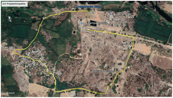
Figure 4.
Giri Pradakshinapatha, the modern circumambulation path around the Hemakuta Hill area. Imagery from Google Earth.
During the 1100–1250 period, all new temples, including one of the two Virupaksha temples, were built at the north foot of the Hemakuta Hill. The exception was the Mula Virupaksha Temple, erected adjacent to the south Bhairava node. The northern Virupaksha temple was established at the very foot of the hill and included an ambulatory, a mandapa that served as a sattra-sale (brahmin feeding house), and three ceremonial gateways (this temple would develop into a temple complex under the Sanagamas), all built using the ornate Dravida architectural language. These early components of the temple have been identified in the architectural accretion that has risen up around them through investigative work (Wagoner 1996; Michell et al. 2001). The 12th century also witnessed the return of Phamsana architecture and of the memorial shrines, re-emerging from their hiatus since the 10th century. Specifically, the royal Immadi Rachamallesvara II Memorial Shrine has been identified in the north Pampa node (Patil 1992, pp. 131, 236).
Among these changes, the Mula Virupaksha Temple’s structural-spatial planning presents a distinctive and sophisticated use of microtopographic landscape features to cultivate a type of corporeal experience of a devotee distinct to that space. Spatial analysis with GIS and GSV illustrates how it was designed to engage the corporeal experience of the devotee in a highly nuanced and carefully planned manner that had not been previously seen at the site. Although the importance of the natural features in the placement and design of the Mula Virupaksha Temple to create this unique corporeal ritual experience within the site was not identifiable through only a GIS analysis, it was very clear through a GSV walk-through of the temple, particularly through spatial planning and the use or appropriation of microtopographic features into the temple’s design, orientation, and placement within the context of the south-north path of movement.
4. Monument Orientation and Use of Microtopographic Features
Temple and shrine orientation is one of the attributes that can easily be analyzed in a GIS as spatial and temporal indices, both as individual structures with potential alignments to landscape features and as group patterns based on structural-spatial, temporal, and cultic factors. The religious setting of the Hemakuta Hill area, initially related to funerary rites and ancestral worship, appears to have necessitated a range of ritual activity spaces signaled through the nonverbal features associated with architecture such as architectural languages, orientation of monuments, location within the Hemakuta Hill area, and integration of microtopographic features. The general uniformity of structures throughout the site from 800 to 900—primarily memorial shrines built in the Phamsana architectural language, in the north Pampa node, facing eastward and the path of movement—suggests that the Hemakuta Hill area then served as a setting for a particular type of religious structure and associated community needs. Divergence from this pattern would have been visually remarkable, communicating nonverbal cues for these exceptional spaces to devotees visiting the Pampa tirtha—three Phamsana shrines, including the Bhairava Shrine and companion shrine in the south Bhairava node, were oriented to face west, and the Pampa Shrine was built using an ornate architectural language, Dravida in a Rastrakuta idiom. These patterns, though based on limited data, signal the types of nonverbal features of importance for monitoring as the pilgrimage space developed over time.
Differences in monument orientation between the south and the north ends of the site materialized diverse ritual needs. The importance of alignment considerations of temples and shrines with cardinal directions and/or with significant landscape or astronomical events is discussed in many texts (sastras and Agamas). Many specialists consider them to be a primary guiding principle for spatial orientation of South Asian religious structures (Hardy 1995, p. 16; Hudson 1995, p. 309; Kramrisch and Burnier 1986, p. 235; Malville 2014; Michell 1988, p. 73) and for imperial era spatial and architectural planning of the Vijayanagara capital city that developed along with the Hemakuta Hill to form an area referred to as the Sacred Center by the Vijayanagara Research Program (Malville and Fritz 1993, 1996, 2006a, 2006b). Temples and shrines could be built facing any direction, and the choice is often dependent on the particular rites staged in the structure (Hudson 1995, p. 309). Consideration is also given to the aspect of the housed deity for its orientation: peaceful gods who should look and be oriented towards habitations versus wrathful gods who should face away from settlements (Kramrisch and Burnier 1986, p. 235). As it is not clear where the local settlement was in relation to the Pampa tirtha, but it is known that the fearsome Bhairava Temple faced west, it can be surmised that temple and shrine orientation at the Pampa tirtha was communicating information about the housed deities and the associated rituals.
Additional considerations were also clearly given for the Mula Virupaksha Temple’s orientation and intentional divergence from true cardinality. The variety of exact orientations of the Pampa tirtha memorial shrines and temples from 800 to 1100 shows that the majority of the shrines faced an easterly direction, with varying degrees of divergence from a true easterly cardinality. Easterly orientations range from 99° to 106° from north. This divergence can be explained, in part, based on the techniques used for establishing cardinal directions, a first and critical part of a temple’s foundation ceremony. Techniques for establishing cardinal directions and shrine orientation in South Asia were already advanced and continued to be refined from the Vedic period into the early medieval period, notably the “Indian Circle” method. Various methods of establishing orientation come from textual sources (sulbasutras [Vedic manuals for building altars], silpa- or vastu-sastras, and the Agamas) based on astronomical knowledge (jyotihsastra), specifically from a Shaiva Siddhanta manual (Ishana Shiva Guru Deva Paddhati) written in the late 11th–early 12th century (Yano 1986). These textual sources were most likely known and used by the Mula Virupaksha Temple’s artisans. The 12th-century Mula Virupaksha Temple, however, was oriented to 83° from magnetic north. Thus, it was built using the Phamsana memorial monument architectural language, oriented outside of the previously established range of what was considered “easterly”. Considering the then known advanced techniques of establishing cardinality, the temple’s divergence from cardinality was likely a calculated decision that warrants investigation.
The Mula Virupaksha Temple consists of an ekanga garbhagriha (a square sanctuary), a narrower antarala (antechamber), and a mostly open nine-bayed mandapa, built to abut the western side of a natural water feature. The water feature is a small spring-fed cistern or pool. The temple is oriented east-northeast (83° east of north (Michell et al. 2001, p. 187)) so that its longitudinal axis is open to the pool. The monument sits on a four-course platform that visibly conforms to the gentle undulation of a granite before the pool (Figure 5). The microtopographic undulation slopes gradually to the north so that the south entrance to the mandapa is even with the granite, whereas the north exit has a flight of stairs leading down a four-course platform foundation, as does the east exit, though the east stairs lead into the adjacent pool. Moreover, the Phamsana superstructure over the garbhagriha consists of three stepped storeys, in keeping with other Phamasana monuments up to this point. Unlike other monuments at the Pampa tirtha, the roof of the mandapa has two drain spouts extending from the parapet on the east side that channeled rain into a pool—signaling a very intentional, proprietary, and intimate relationship between the temple and the water feature.
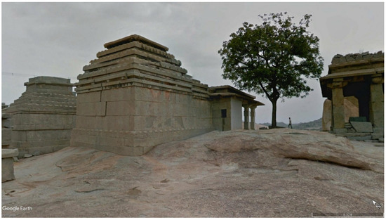
Figure 5.
View looking northwest of the back (west side) of the Mula Virupaksha Temple. Imagery from Google Earth.
Additionally, the Mula Virupaksha Temple’s nine-bayed mandapa was not fully open. The row of bays closest to the entrance of the temple was enclosed, which was uncommon in the Hemakuta Hill area, while the other bays remained open, thus creating an intimate space for worship. Figure 6 is a view slightly west of south, capturing the north exit of the temple (whitewashed), the cistern, and the kalla upparige (gateway, discussed further below) to the south. This unique mandapa plan and temple orientation intentionally framed the lines of sight for the devotee entering and exiting the temple space and while in the mandapa. The mandapa space and siting of the Mula Virupaksha Temple encouraged an intimate space for ritual activity and darshan (the sacred act of beholding, visual correspondence) between the devotee and the housed deity, unseen from the surrounding landscape in the alcove-type space that the semi-closed mandapa form provided. Indeed, when looking out of the temple, along its longitudinal axis, the devotee sees the pool, granitic boulders of the hill, then in the distance, the sacred Matanga Hill; not the other devotees moving through and worshipping in the Pampa tirtha space, nor other monuments (Figure 7). The only other structures at the top of the Hemakuta Hill by the 12th century were the Bhairava Temple and a companion shrine in the south Bhairava node. As mentioned, these two monuments are in a slight depression that is not observable through digital elevation data available for the site, but the depression is perceptible through GSV. This depression hides the Bhairava Temple and companion shrine from the view of the Mula Virupaksha Temple, possibly acting to hide the gaze of the fearsome Bhairava. Likewise, the rest of the pilgrimage site was not visible once inside the depression, at least not until the 1250–1325 period. As such, it is clear that the microtopographic feature was utilized as a location for the Bhairava Temple and companion shrine to restrict their visibility and thus engendered an introspective and contained experience for devotees.
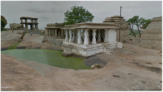
Figure 6.
View looking south-southwest of the Mula Virupaksha Temple (whitewashed) and the water feature (from the east side of the water feature). The kalla upparige is pictured in the far left. Imagery from Google Earth.
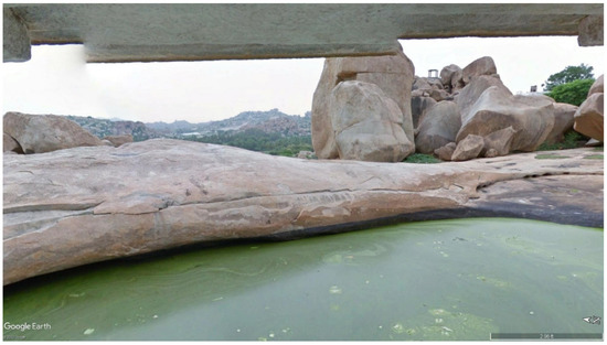
Figure 7.
View looking west from the Mula Virupaksha mandapa, looking out over the cistern and the Matanga Hill in the far distance. Imagery from the Google Earth website.
Traditionally, temples are entered along their longitudinal axis, however, the unique design of the Mula Virupaksha Temple that allowed it to appropriate the pool and its particular southern remarkable view presents a temple plan in which the devotee enters the mandapa space from the south, exits from the north, along its transverse, south-north axis. Such a plan intercepts devotees moving northward through the site, reproducing the original south-north axis of movement that orients the site in space and conceptually. Thus, when the devotee enters into the sacred space of the hill from the southeast boulder mound, they can choose to travel into the microtopographic depression of the south Bhairava node, or they can proceed immediately northwards to the Mula Virupaksha Temple and continue onwards towards Pampa and the river. Indeed, as the devotee exits the mandapa, the artisans crafted another carefully manufactured line of sight to the north Pampa node and the north Virupaksha area, establishing a deep connection between Pampa and Virupaksha, part of a series of strategies for naturalizing Virupaksha at the Pampa tirtha (Figure 8).
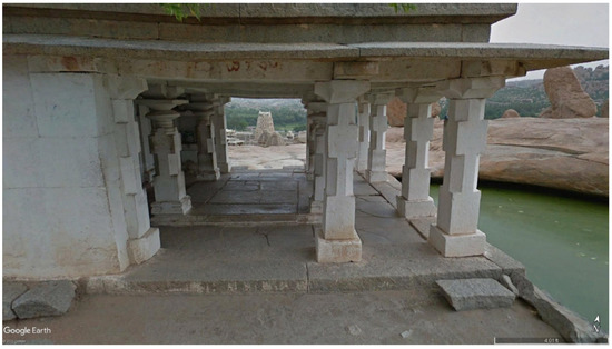
Figure 8.
View looking north of the Mula Virupaksha mandapa, along the transverse axis of the temple. Imagery from Google Earth.
5. The Pampa-Virupaksha Relationship
The incorporation of the microtopographic feature of the pool and the granitic contours of the hill into the overall design of the Mula Virupaksha Temple was unprecedented at the site. Previously, relatively flat surfaces of the hill or the flat surface of the foot of the hill was prioritized for the placement of shrines and temples. Moreover, architectural plans of shrines and temples did not incorporate topographic features in their siting arrangements. (Figure 9 of two 1050–1100 shrines built on the north face of Hemakuta Hill, plus the Pampa Temple with the Royal Immadi Rachamalessvara Memorial Shrine in the background). Additionally, monuments that were built pre-12th century were situated to be in proximity or have a direct line of sight to the Pampa Temple, in the north, and to the path of movement across the site. Only the west-facing Bhairava and companion shrine were situated to have no line of sight to Pampa through their intentional placement in the microtopographic depression at the south end of the Hemakuta Hill.
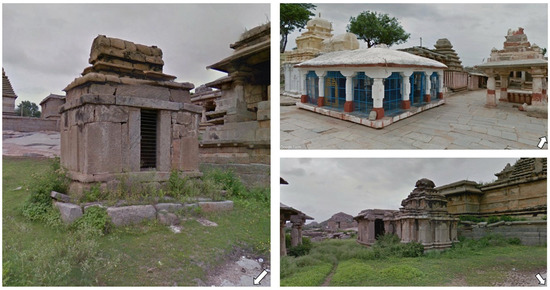
Figure 9.
Bottom right image and left image of two Dravida shrines built during the 1050–1100 period, located on the north face of the Hemakuta Hill. Top right image of the Pampa Temple in the foreground and the Royal Immadi Rachamallesvara Memorial Shrine. Imagery from Google Earth.
Much like the Mula Virupaksha Temple’s placement and use of space, the artisans’ choice to utilize the Phamsana architectural language for it suggests that their choices were meant to naturalize the temple’s place at the tirtha. Before the 12th century, the use of Phamsana was not consistent. As pointed out above, it was popular during the 800–900 period for memorial cult shrines. There was a considerable gap in the construction activity at the site for a couple of generations after 900 until the erection of the first structures of the 1050–1100 period. The beginning of the renewed construction activity in the 1050–1100 period saw a break from the simple Phamsana shrines. Newly built shrines and small temples were designed with the ornate Dravida architectural language. During this period, the ritual activities associated with the Pampa and Bhairava were still a part of the tirtha’s function, attested to by renovations to their shrines, expanding them into temple form. The 12th-century changes in the site connected Virupaksha to the earliest trends of Phamsana architecture in the Hemakuta Hill area. The choice to use the earliest architectural language of the site by the new artisans enabled them to present an impression of a god that was already a part of the original sacred fabric of the site. Such calculated application of older architectural forms was a deliberate political move, as identified and discussed by Eaton and Wagoner in their work throughout the Deccan Plateau during the medieval and early modern period (Eaton and Wagoner 2014).
The importation of Virupaksha into the Pampa tirtha marks a deliberate Sanskritization of the sacred space, a change made possible through the ritual and mythological marriage of the god to the goddess Pampa, who personified the sacred power of the site. Sanskritization herein refers to the process of tying a minor local deity or genii loci to a manifestation of Shiva, an observed process at other early medieval sites across South Asia (e.g., Tanjavur and Madurai) by ambitious regional political players, such as local chieftains, in an attempt to benefit from such local progenitors of power (Stein and Arnold 2010, pp. 118–19). As such, this process not only elevated the site of a local goddess, but also the status of a local ruler through his association and investment in such sacred spaces (Stein 1960, p. 119). Therefore, politically ambitious elites seized upon the trend of conspicuously donating for the maintenance and development of the Pampa tirtha as an opportunity to influence the ritual experience of a growing and diversifying devotee base. Thankfully, a lengthy donative inscription was left by one such ambitious local ruler, a Sinda chief, Maiduna Chaudayya in 1199 (SII [1923] 1986, p. 54). They took control of the area in the 12th century until another local group, the Kampili, replaced them in the following century. The 1199 inscription illustrates the extent to which one individual was able to influence the Hemakuta Hill landscape. In addition to installing a linga for his Sinda overlord, Rachamallesvara in the Immadi Rachamallesvara memorial shrine, he gave a litany of gifts to the three primary gods of the site: Pampa, Bhairava, and Virupaksha (this is the first epigraphic evidence available that records the presence of Virupaksha). Chaudayya donated plots of land that supplied funds for daily food offerings to the gods, ritual objects, and he was the patron for several key Virupaksha auxiliary structures (associated with the northern Virupaksha Temple), including the ambulatory and gateways. His inscription also records grants for feeding a newly arrived brahman community associated with Virupaksha. Although this inscription does not mention the Mula Virupaksha Temple explicitly, it is clear that Chauddaya’s ambitions benefited from investing in the Pampa tirtha at a moment when it was transforming through Sanskritization.
Virupaksha’s marriage to Pampa was recorded in the Pampamahatmyam (a sthala purana, myths of place), written in Kannada, promoting the site’s mythic origin and traditions. The date that the Pampamahatmyam was originally written is uncertain, but it primarily recounts the marriage of Pampa to Virupaksha. This act was so important that the marriage became part of the seasonal festivals of the Virupaksha Temple Complex during the imperial era, if not earlier, and continues to be practiced (Das 2006; Kotecha 1982; Verghese 1995; Wagoner 1991, 1996). To this day, annual festivals are held to celebrate the betrothal of Pampa and Virupaksha (Phalapuja), and their marriage festival (Kalyanotsava) (Kotecha 1982; Verghese 2004, p. 420). Perhaps more importantly, with the transition to a Virupaksha-Pampa pilgrimage and cult center, as opposed to its previous life as Pampa-Bhairava tirtha, the Hemakuta Hill area became accessible to a wider and non-local audience of devotees through Virupaksha associated with Shiva. By transforming a god whose name translates to “misformed eye” into a householder (he is not married at other sites of his worship in the Bellary District), Pampa also acquired a larger audience through their mythological marriage and her correspondence to Parvati, the wife of Siva. Establishing a Sanskritic deity at the pilgrimage site thus assured a ritual space for future religious expansion beyond local deities, and also established the growing importance and non-local reach of the center. However, after the merging of their two cults, Pampa lost her primacy over the religious life in the Hemakuta Hill area as she became the wife of Virupaksha.
6. Mid-13th Century Renovation: The Kalla Upparige and Devotee Movement
In the 1250–1325 period, the Mula Virupaksha Temple was renovated through a novel architectural form of an auxiliary ritual structure: the kalla upparige (stone palace), a multistoried stone entrance pavilion or freestanding gateway (Wagoner 2001). This monumental gateway was erected 60 m south of the temple, along its south-north axis of orientation, which served to enhance the significance of the south-north path of movement and overall axis of the site. In fact, the Mula Virupaksha Temple’s kalla upparige was the first of the five recorded examples of this monument type, three of which were in the Vijayanagara area. All were built in the 13th through to the 15th centuries and were associated with a temple (located to their south) to which a southern doorway, passageway, and monumental flight of stairs led (Wagoner 2001). Built on the granitic sheetrock outcropping of the hill, the multistoried stone entrance pavilion was square with a raised rectangular platform on either side of a central and equally proportioned rectangular passageway. Traces of plaster indicate that the first floor’s perimeter was walled in, unlike the second floor for which Wagoner has identified perforated holes, suggesting that it was partitioned with fabric (Michell et al. 2001, pp. 192–93). Based on the two intact kalla upparige at Citradurga, the Mula Virupaksha entrance pavilion likely had a third storey, which was not preserved. Similar to a palace, as its name implies, a portable image of Virupaksha, belonging to the Mula Virupaksha Temple, would have taken residence here and been displayed for special rituals from the second or third storey. The upper floors provided excellent vantage points for devotees to have darshan with the god, especially for worshippers unable to enter the Mula Virupaksha Temple or the north Virupaksha Temple due to their low social class.
As was the case with the temple, the gateway’s location served several strategic corporeal management functions for enhancing the presence and authority of the Virupaksha cult in the Hemakuta Hill area. Situated to the south of the Mula Virupaksha Temple, along its transverse south-north axis of orientation, the kalla upparige extended Virupaksha’s ritual space on the hill, establishing its own node of ritual activity. The kalla upparige’s siting allowed it to directly channel devotees into the sacred space of the Pampa tirtha from the natural point of entry in the sacred space of the hill, beside a mound of boulders on the south-east side of the hill (visible in Figure 10). In addition to directing the body into the pilgrimage space, the structure’s orientation at 352° from north also channeled the devotee’s gaze directly to the Mula Virupaksha Temple. Moreover, the passageway’s narrow space limited the amount of social interaction possible (as can be seen in Figure 11), suggesting that the transition of spaces was designed for one person at a time. Thus, Virupaksha was further integrated into the south-north path of movement organizing and structuring the site (see Figure 3).
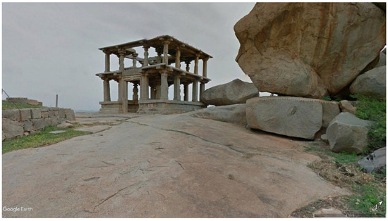
Figure 10.
View looking north-west of the kalla upparige from the mound of boulders situated before the natural entry point onto the Hemakuta Hill. Imagery from Google Earth.
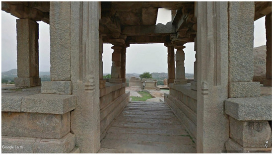
Figure 11.
View looking north through the kalla upparige, towards the Mula Virupaksha Temple. Imagery from Google Earth.
Consequently, this monumental gateway provided a unique means for a physical and sensorial transition into an area, which was conceptualized as a contained sacred space. For this reason, Wagoner points out that this new form of architecture, the kalla upparige, led the devotee “to a ritually defined space” much as a gopura (towered temple gateways) led the devotee into a walled temple precinct (Wagoner 2001, p. 173). The Mula Virupaksha kalla upparige conceptually resembles the eight mystic entrances into the Pampa tirtha discussed in later sthala puranas (Das 2006). Das describes these gateways as “places fit for engaging in spiritual practices that lead to devotion, thus qualifying one to enter the sacred area” (Das 2006, p. 382). Like the kalla upparige, they functioned to “create the proper frame of mind to comprehend the dignity of Pampakshetra and…attain proximity to Siva” (Das 2006, p. 382).
The corporeal experience of moving through a dim passage in the walled-in gateway towards the light of the exit and the Mula Virupaksha Temple, was likely intense and personal, echoing the quality of ritual space provided by the temple’s architectural and spatial planning for devotee worship in the mandapa. The grandeur and centrality of the god Virupaksha was enhanced through the corporeal experience of the gateway through which the devotee was moved into an introspective and personal space that culminated in the revelation of the Mula Virupaksha Temple. Thus, this gateway marked and mediated devotee access to the Hemakuta Hill sacred space and was intended to stress the importance of Virupaksha through corporeal management of the devotees, in addition to functionally providing additional ritual space of the temple’s icon to be displayed for worship.
Therefore, we can interpret the gateway as a means for spiritually preparing the devotee’s entrance into the sacred space, albeit with an agenda of creating an experience initiated and dominated by Virupaksha. Conversely, during previous periods, a devotee entered the Hemakuta Hill space from the same point of entry on which the kalla upparige sits, namely on the upper ridge of the microtopographic depression where the Bhairava Temple is. Thereby, until the mid-13th century, a devotee could summit the hill and immediately see and descend towards the Bhairava Temple. With the aforementioned stone gateway in place, this was no longer the case, as the structure mostly blocked from view the Bhairava Temple and instead led the devotee to the Mula Virupaksha Temple. Besides, situated at the highest point of the sheetrock part of the hill—excluding boulder formations—the kalla upparige provided unparalleled visibility for a Virupaksha icon placed in the second or third storey and towered over the southern and once Bhairava-dominated space. As observed through GSV, the gateway visually imposes itself on the path of movement, as it is visible along much of the path and outside of the Hemakuta Hill area. Therefore, the height of the gateway and its location on the hill’s highest point established the structure as a major landmark. After it was built and functional, the gateway drastically changed the way devotees conceptualized and oriented themselves in the sacred space of the Pampa tirtha.
7. Conclusions
Together, the Mula Virupaksha Temple and its monumental stone gateway came to coopt and command devotee corporeal experience on the Hemakuta Hill. The innovation of the kalla upparige was certainly the latest mechanism in a brahman and ambitious local ruler-led program to integrate and naturalize Virupaksha into the once Pampa-and-Bhairava-dominated space. The overall design of the Mula Virupaksha Temple and the gateway suggests that the Virupaksha’s influence in the Hemakuta Hill area, as of the 12th century, brought about an evolving religious architectural tradition promoting intense darshan experiences while simultaneously naturalizing the newly imported god in the sacred space of the Hemakuta Hill. The very features of the Hemakuta Hill, the microtopographic features, became crucial elements of composing a unique and powerful ritual experience focused on Virupaksha.
It is impossible to “know” all of the different perceptions and experiences of space from the past, as Fogelin rightly discusses in his analysis of sacred landscapes (Fogelin 2006, p. 74). Many of the differences in perception of space are dictated through social codes that permit and restrict actions based on age, gender, and social class, but also through the sheer fact that each body and mind have its own corporeality, history, and attitudes affecting movements, meanings, and experience (Ashmore and Knapp 1999, p. 16). The differences between particular individuals and groups may be amplified, or there may be attempts to dissolve interpersonal boundaries through specific experiences choreographed into spatial ordering. These are the sorts of experiences that we can identify through spatial analysis. The intended corporeal experiences of devotees as orchestrated by dominant groups are among those experiences. The spatial and temporal patterns in the Hemakuta Hill area indicate that space and devotee ritual corporeal experience was a resource that underwent certain changes and was managed through novel mechanisms in the 12th century to naturalize and embed a new cult, its patrons, and its associated religious community at the sacred space that once was dominated by the goddess Pampa and her counterpart Bhairava.
As the present article has argued, a significant shift in the cultic nature of the site occurred with the introduction of Virupaksha. We can say through the use of GSV and GIS that this change at the Hemakuta Hill area, appearing circa 1100, presents a religious architectural tradition that promoted intense ocular sensorial experiences and naturalized the newly imported Virupaksha and its religious community. The Hemakuta Hill area transformed from a site characterized by small and accessible memorial monuments where local kin groups worshipped their ancestor to the Virupaksha cult of increasing complexity and ritual experiences. The novel architectural decisions in the design and placement of the Mula Virupaksha Temple and associated kalla upparige had no precedence at the site, marking a major alteration in its spatial organization. The temple imposed itself into the flow of movement that maintained the site’s directional organization and used orientation and lines of sight to manage devotee experience while establishing visual associations between Virupaksha structures. The artisans of the Mula Virupaksha monuments did, however, adopt and develop the established architectural language of Phamasana and a precedence for using microtopographic features to promoting and managing devotee introspection from the Bhairava Temple located in a microtopographic depression. Consequently, the temple and gateway greatly expanded on the use of the landscape to naturalize and heighten the presence of the new cult at the Pampa tirtha, while affording devotees amplified embodied ritual experiences. This trend continued and expanded into the early imperial phase as part of an architectural program to order space and elevate the status of Virupaksha, adopted as the imperial patron deity, and enhanced the reputation of the new Vijayanagara imperial rulers.
Funding
This research received no external funding.
Conflicts of Interest
The author declares no conflict of interest.
References
- ARIE. 1935. Annual Report on Indian Epigraphy, 1934–1935. Delhi: Manager of Publications. [Google Scholar]
- Ashmore, Wendy, and Arthur Bernard Knapp. 1999. Archaeology of Landscapes: Contemporary Perspectives. Malden: Wiley. [Google Scholar]
- Bakker, Hans. 2007. Monuments to the Dead in Ancient North India. Indo-Iranian Journal 50: 11–47. [Google Scholar] [CrossRef]
- Bell, Catherine. 2009. Ritual Theory, Ritual Practice. New York: Oxford University Press. [Google Scholar]
- Bharne, Vinayak, and Krupale Krusche. 2013. Rediscovering the Hindu Temple: The Sacred Architecture and Urbanism of India. Newcastle: Cambridge Scholars Publishing. [Google Scholar]
- Burgess, Jas, ed. 1877. Indian Antiquary 6 (1877). Bombay: Education Society’s Press. [Google Scholar]
- Das, Asim Krishna. 2006. The Mystic Gateways into Pampakshetra: Based on the Pampamahatmyan and Inscriptional Evidence. In Vijayanagara: Archaeological Exploration, 1990–2000. Edited by Channabasappa S. Patil, John M. Fritz, Robert P. Brubaker and Teresa Raczec. New Delhi: Manohar, pp. 381–402. [Google Scholar]
- Eaton, Richard, and Philip Wagoner. 2014. Power, Memory, Architecture: Contested Sites on India’s Deccan Plateau, 1300–1600. New Delhi: Oxford University Press. [Google Scholar]
- Fogelin, Lars. 2006. Archaeology of Early Buddhism. Lanham: Altamira Press. [Google Scholar]
- Haak, Candis. 2018. Corporeal Experience and the Material World of the Vijayanagara Sacred Landscape: 600–1325 CE. Ph.D. dissertation, University of Toronto, Toronto, ON, Canada. [Google Scholar]
- Haak, Candis. 2022. An Early Saivite Pilgrimage Landscape: The Persistence of Pampa and Bhairava in the Hemakuta Hill Sacred Space, 800–1325 CE. Religions 13: 569. [Google Scholar] [CrossRef]
- Hardy, Adam. 1995. Indian Temple Architecture: Form and Transformation. New Delhi: Indira Gandhi National Center for the Arts and Abhinav Publications. [Google Scholar]
- Hiltebeitel, Alf, ed. 1989. Criminal Gods and Demon Devotees. Essays on the Guardians of Popular Hinduism. Albany: State University of New York Press. [Google Scholar]
- Hudson, D. Dennis. 1995. How to Worship at Siva’s Temple. In Religions of India in Practice. Edited by Donald S. Lopez. Princeton: Princeton University Press, pp. 304–20. [Google Scholar]
- Kotecha, Dipak. 1982. The Hindu Ritual Movement: Study of Sri Virupaksha Temple, Humpi. Completion’s thesis, School of Architecture, Ahmedabad, India. [Google Scholar]
- Kramrisch, Stella. 1994. The Presence of Śiva. Princeton: Princeton University Press. [Google Scholar]
- Kramrisch, Stella, and Raymond Burnier. 1986. The Hindu Temple. Delhi: Motilal Banarsidass. [Google Scholar]
- Malville, J. McKim. 2014. Astronomy of Indian Cities, Temples, and Pilgrimage Centers. In Handbook of Archaeoastronomy and Ethnoastronomy. Edited by Clive L. N. Ruggles. New York: Springer Reference, pp. 1969–80. [Google Scholar]
- Malville, J. McKim, and John M. Fritz. 1993. Recent Archaeo-Astronomical Research at Vijayanagara. In South Asian Archaeology. Edited by Adalbert J. Gail and Gerd J. R. Mevissen. Stuttgart: Franz Steiner Verlag Wiesbaden, pp. 415–25. [Google Scholar]
- Malville, J. McKim, and John M. Fritz. 1996. Astronomical Studies of Vijayanagara: The Sacred Hills. In Vijayanagara: Progress of Research 1988–1991. Edited by D. V. Devaraj and Channabasappa S. Patil. Mysore: Directorate of Archaeology and Museums, pp. 221–35. [Google Scholar]
- Malville, J. McKim, and John M. Fritz. 2006a. Astronomical Orientations of the Larger Temples. In Vijayanagara: Archaeological Exploration, 1990–2000. VRP Monograph 10. Edited by Channabasappa S. Patil, John M. Fritz, Robert P. Brubaker and Teresa P. Raczek. New Delhi: Manohar and American Institute of Indian Studies, pp. 363–74. [Google Scholar]
- Malville, J. McKim, and John M. Fritz. 2006b. Astronomical Orientations of the Smaller Temples, Shrines and Palaces. In Vijayanagara: Archaeological Exploration, 1990–2000. VRP Monograph 10. Edited by Channabasappa S. Patil, John M. Fritz, Robert P. Brubaker and Teresa P. Raczek. New Delhi: Manohar and American Institute of Indian Studies, pp. 375–80. [Google Scholar]
- Meister, Michael W. 1976. Phāṁsanā in Western India. Artibus Asiae 38: 167–88. [Google Scholar] [CrossRef]
- Michell, George. 1988. The Hindu Temple: An Introduction to Its Meaning and Forms. Chicago: University of Chicago Press. [Google Scholar]
- Michell, George, Phillip B. Wagoner, and Jayaram Poduval. 2001. Vijayanagara: Architectural Inventory of the Sacred Centre. New Delhi: Manohar, vols. 1–3. [Google Scholar]
- Patil, Channabasappa S. 1992. Temples of Raichur and Bellary Districts, Karnataka, 1000–1325 A.D. Mysore: Directorate of Archaeology and Museums. [Google Scholar]
- SII. 1939. South Indian Inscriptions. Madras: Government of India, Manager of Publications, vol. IX. [Google Scholar]
- SII. 1986. South Indian Inscriptions. Mysore: The Director General Archeological Survey of India, vol. IV. First published 1923. [Google Scholar]
- Stein, Burton. 1960. The Economic Function of a Medieval South Indian Temple. Journal of Asian Studies 19: 163–76. [Google Scholar] [CrossRef]
- Stein, Burton, and David Arnold. 2010. A History of India. Chichester: Wiley-Blackwell. [Google Scholar]
- Verghese, Anila. 1995. Religious Traditions at Vijayanagara as Revealed through Its Monuments. New Delhi: Manohar. [Google Scholar]
- Verghese, Anila. 2000. Archaeology, Art and Religion: New Perspectives on Vijayanagara. New York: Oxford University Press. [Google Scholar]
- Verghese, Anila. 2004. Deities, Cults and Kings at Vijayanagara. World Archaeology 36: 416–31. [Google Scholar]
- Wagoner, Phillip B. 1986. Mode and Meaning in the Architecture of Early Medieval Telangana (C. 1000–1300). Ph.D. dissertation, University of Wisconsin–Madison, Madison, WI, USA. [Google Scholar]
- Wagoner, Phillip B. 1991. Architecture and Mythic Space at the Hemakuta Hill: A Preliminary Report. In Vijayanagara Progress of Research, 1984–1987. Edited by D. V. Devaraj and Channabasappa S. Patil. Mysore: Directorate of Archaeology and Museums, pp. 142–48. [Google Scholar]
- Wagoner, Phillip B. 1996. From “Pampa’s Crossing” to “The Place of Lord Virupaksha”: Architecture, Cult, and Patronage at Hampi before the Founding of Vijayanagara. In Vijayanagara: Progress of Research 1988–91. Edited by D. V. Devaraj and Channabasappa S. Patil. Mysore: Directorate of Archaeology and Museums, pp. 141–74. [Google Scholar]
- Wagoner, Phillip B. 2001. Kannada Kalla Upparige (Stone Palace): Multistoried Entrance Pavilions in Pre- and Early Vijayanagara Architecture. Ars Orientalis 31: 167–83. [Google Scholar]
- Yano, Michio. 1986. Knowledge of Astronomy in Sanskrit Texts of Architecture (Orientation Methods in the Īśānaśivagurudevapaddhati). Indo-Iranian Journal 29: 17–29. [Google Scholar]
Publisher’s Note: MDPI stays neutral with regard to jurisdictional claims in published maps and institutional affiliations. |
© 2022 by the author. Licensee MDPI, Basel, Switzerland. This article is an open access article distributed under the terms and conditions of the Creative Commons Attribution (CC BY) license (https://creativecommons.org/licenses/by/4.0/).