Article

Modeling the Future of a Wild Edible Fern Under Climate Change: Distribution and Cultivation Zones of Pteridium aquilinum var. latiusculum in the Dadu–Min River Region

1
Sichuan Provincial Forest and Grassland Key Laboratory of Alpine Grassland Conservation and Utilization of Tibetan Plateau, College of Grassland Resources, Southwest Minzu University, Chengdu 610041, China
2
Key Laboratory of Biodiversity and Environment on the Qinghai-Tibetan Plateau, Ministry of Education, School of Ecology and Environment, Tibet University, Lhasa 850000, China
3
Ecological Security and Protection Key Laboratory of Sichuan Province, Mianyang Normal University, Mianyang 621000, China
4
School of Life Science, South China Normal University, Guangzhou 510631, China
*
Author to whom correspondence should be addressed.
These authors contributed equally to this work.
Plants 2025, 14(14), 2123; https://doi.org/10.3390/plants14142123
Submission received: 3 June 2025 / Revised: 7 July 2025 / Accepted: 8 July 2025 / Published: 9 July 2025
(This article belongs to the Section Plant Response to Abiotic Stress and Climate Change)

Abstract

Under the pressures of global climate change, the sustainable management of plant resources in alpine gorge regions faces severe challenges. P. aquilinum var. latiusculum is widely harvested and utilized by residents in the upper reaches of the Dadu River–Min River basin due to its high edible and medicinal value. This study employed ensemble models to simulate the potential distribution of P. aquilinum var. latiusculum in this region, predicting the impacts of future climate change on its distribution, the centroid migration of suitable habitats, and niche dynamics. A production dynamics model was also constructed to identify current and future potential cultivation areas by integrating ecological suitability and nutritional component synergies. The results show that current high-suitability areas and core cultivation zones of P. aquilinum var. latiusculum are predominantly distributed in patchy, fragmented patterns across the Wenchuan, Li, Mao, Luding, and Xiaojin Counties and Kangding City. Under climate change, the “mountain-top trap effect” drives a significant increase in high-suitability areas and core cultivation zones, while moderate-to-low-suitability areas and marginal cultivation zones decrease substantially. Meanwhile, suitable habitats and cultivation areas exhibit a northward migration trend toward higher latitudes. The most significant changes in suitable area and cultivation zone extent, as well as the most pronounced niche shifts, occur under high-emission climate scenarios. This research facilitates the development of suitability-based management strategies for P. aquilinum var. latiusculum in the study region and provides scientific references for the sustainable utilization of montane plant resources in the face of climate change.

1. Introduction

The utilization of plant resources under climate change has long been a focal area of global concern, attracting the attention of researchers across various disciplines, including geography, ecology, and archeology [1,2,3,4,5]. Existing studies indicate that among numerous influencing factors, non-climatic factors dominate short-term biological changes in plants. In contrast, climate change remains the primary driver affecting plant growth, development, and suitable distribution [5,6]. Herbivorous plant resources, as a unique category, are closely intertwined with human development [1,7,8]. The nutritional components of herbivorous plants form the basis for their edibility, with rich nutrients and favorable flavors serving as critical prerequisites for their selection by local communities [9,10]. Research indicates that climate change will affect the habitats of herbivorous plants, potentially leading to significant shifts and migrations in their spatial distribution, while altering the quantity and quality of their nutritional components [11,12,13,14,15]. Given the long-term persistence of climate change, scientifically evaluating its future impacts on the distribution of herbivorous plants is of great value for biodiversity conservation and sustainable ecosystem management.
Species distribution models (SDMs) utilize species occurrence records and environmental data (e.g., climate, topography) to construct species niches through specific algorithms, project them onto the entire study area, and ultimately display suitable habitats or potential distribution areas as probability maps [16,17,18,19]. Over the past decade, using SDMs and climate change scenarios to predict plant species’ suitable habitats has become a hotspot in global change ecology and plant ecology research [20,21,22]. SDMs encompass diverse types with significant methodological differences. The Biomod2(V4.25) platform in R software allows users to customize ensemble models by freely combining algorithms for target species [19,23,24]. While inherent flaws in individual models are unavoidable, optimal simulation results can be achieved by assigning weights to each model within the ensemble [25,26].
Pteridium aquilinum var. latiusculum, renowned as the “king of wild vegetables,” is also called Jixiangcai (lucky vegetable) or Longtoucai (dragon-head vegetable). Belonging to the genus Pteridium within the family Pteridaceae, this herbaceous plant thrives in sunny areas, and is primarily found in sparse coniferous and mixed broad-leaved forests. It is harvested when its young stems and leaves are tender and covered with white villi [27,28]. Fresh P. aquilinum var. latiusculum is rich in nutrients, including protein, dietary fiber, and vitamins, and contains eight essential amino acids and multiple trace elements, making it a delicious, tender, and highly nutritious option [27,29]. Additionally, it is abundant in bioactive components, including terpenoids, steroids, organic acids, flavonoids, and polysaccharides, offering health benefits such as swelling reduction, sedation, nourishment, anti-inflammatory effects, heat-clearing properties, expectorant effects, antioxidant properties, and hypoglycemic effects through regular consumption [30,31,32,33]. It is noteworthy that moderate consumption of P. aquilinum var. latiusculum is safe, but excessive or long-term heavy consumption may pose health risks. This is because P. aquilinum var. latiusculum contains ptaquiloside, which may pose a carcinogenic risk, while oxalic acid and crude fiber may trigger indigestion or carry stone-related risks [29,32,33].
The upper reaches of the Dadu River–Min River basin are characterized by a dual attribute of “alpine gorge barrier” and “resource-constrained livelihoods” [34,35]. Due to topographical constraints and transportation barriers, traditional livelihoods still play a significant role in the daily lives of residents. Field surveys indicate that P. aquilinum var. latiusculum is widely utilized by residents in this region; it is primarily collected and consumed as a food source. From April to May each year, locals harvest their young shoots as wild vegetables, which are processed through stir-frying, blanching, or cold dressing (Figure S1). Relevant studies indicate that some wild herbivorous plants in this region are highly vulnerable to climate change [36,37]. Current research on P. aquilinum var. latiusculum primarily focuses on its chemical composition, plant physiology, and pharmacological effects [30,31,32,33,38], but the mechanisms of adaptation to climate change in the Dadu River–Min River basin remain unclear.
In summary, this study focuses on the upper reaches of the Dadu River–Min River basin and P. aquilinum var. latiusculum to achieve the following objectives: (1) predict changes in suitable habitat areas under different climate scenarios, (2) analyze niche dynamics of P. aquilinum var. latiusculum under future climate conditions, and (3) develop a suitability–productivity model to delineate potential cultivation areas. These results will provide a theoretical foundation for the sustainable utilization of P. aquilinum var. latiusculum in this region.

2. Results

2.1. Current Distribution Projections and Model Accuracy Validation

The simulation results from each model for P. aquilinum var. latiusculum show that suitable areas are generally concentrated in the eastern, southern, and central parts of the upper Dadu River–Min River basin. While all models exhibited consistent overall trends, notable differences existed in their specific predictions (Figure S2). Evaluating model accuracy using valid metrics is critical for determining model reliability and applicability. This study used the “biomod_tuning” function to optimize model parameters, checking them in each iteration against selected metrics (ROC, Kappa, or TSS). Among single models, GBM, RF, and Maxent were ideal for predicting the potential spatial distribution of P. aquilinum var. latiusculum, whereas GAM, ANN, and SRE performed poorly (Figure 1). The ensemble model (“Ensemble”) demonstrated exceptional accuracy, with mean values of 0.972 for TSS, 0.998 for ROC, and 0.950 for KAPPA (Figure 1). The test results showed that Ensemble, constructed via weighted averaging, significantly outperformed other models in terms of precision. Thus, Ensemble provided the best fit and most reliable predictions.

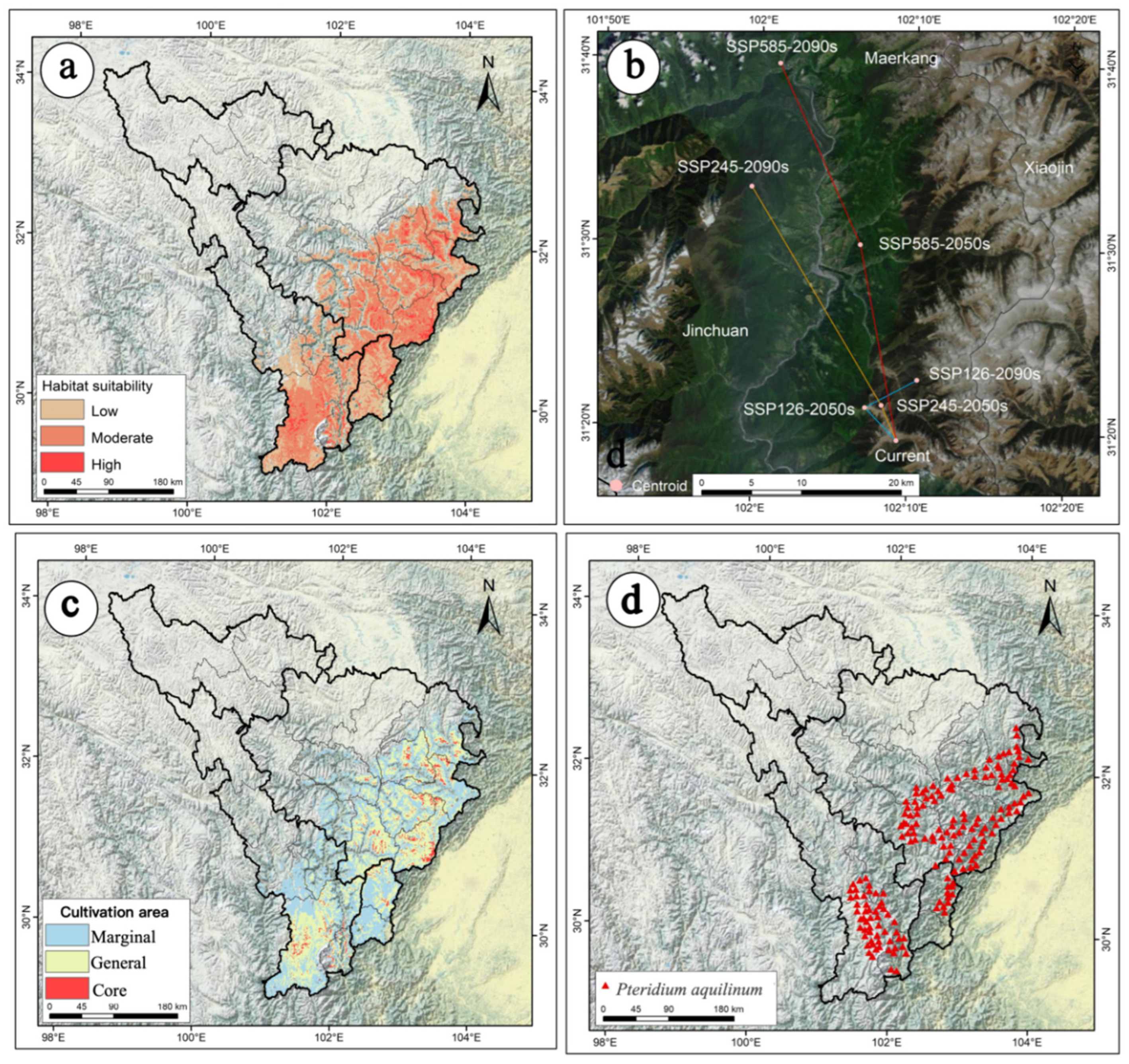
2.2. The Current Potential Distribution of P. aquilinum var. latiusculum in the Upper Dadu River–Min River Basin

The predictive model for P. aquilinum var. latiusculum’s potential suitable habitat exhibited excellent fitting performance. As shown in Figure 2a, the total area of suitable habitat was 6.23 × 10⁴ km2 (Table 1). High-suitability areas accounted for 0.36 × 10⁴ km2 (5.78% of total suitable habitat), primarily distributed in patchy, fragmented patterns across the Wenchuan, Li, Mao, Luding, and Xiaojin Counties and Kangding City (Figure 2a). Moderate-suitability areas covered 3.25 × 10⁴ km2 (52.17% of total suitable habitat), forming a massive perimeter around high-suitability zones (Figure 2a).

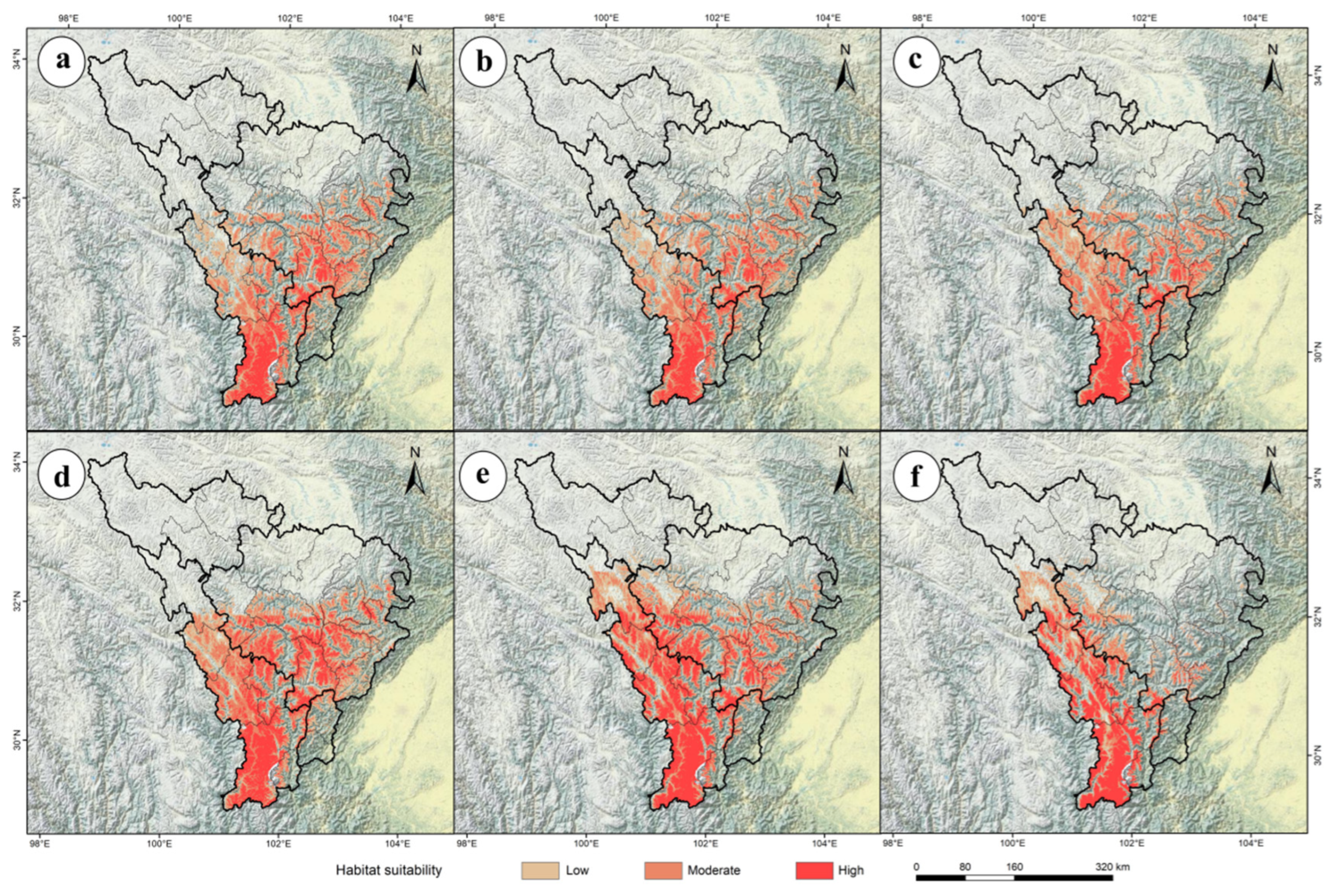
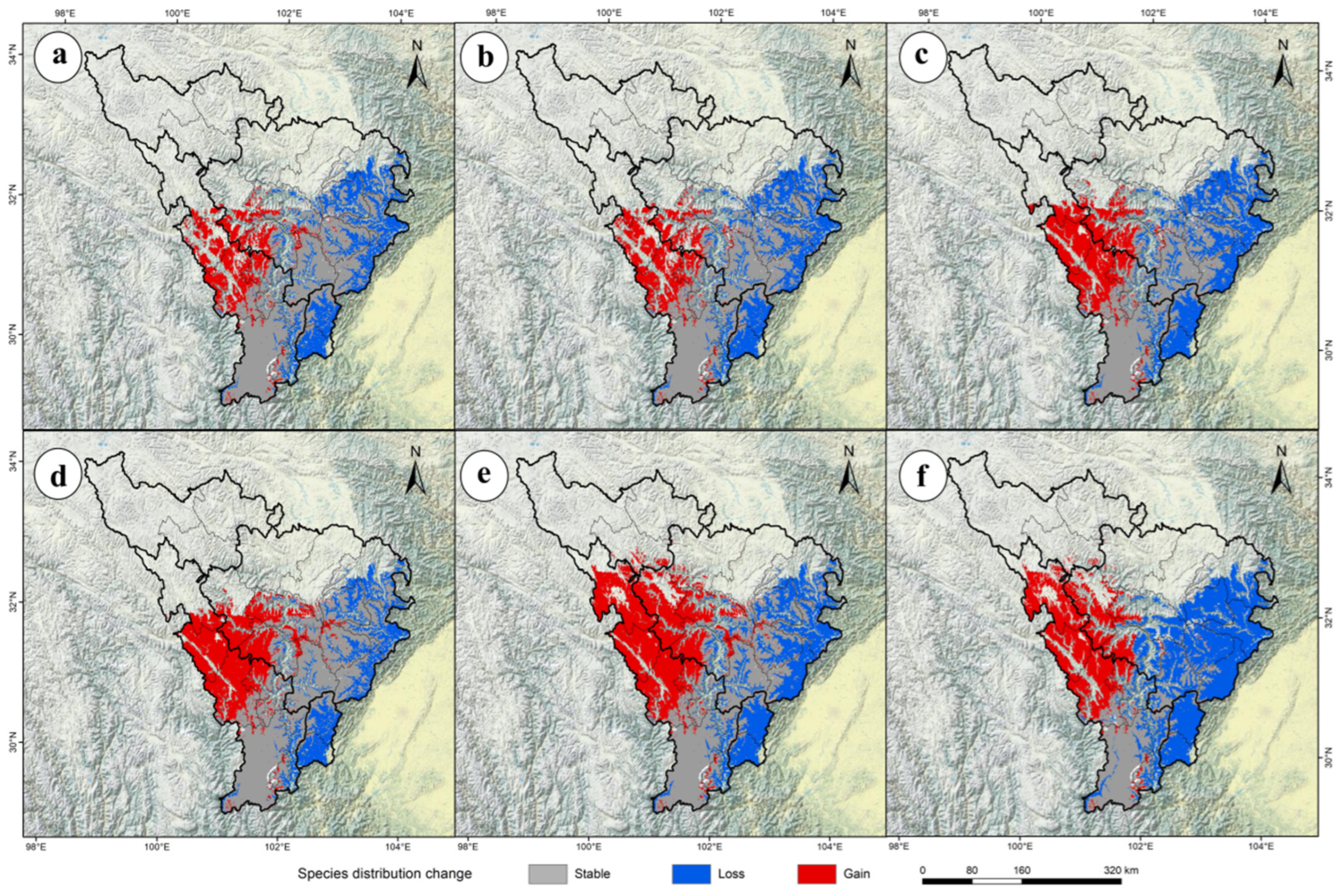
2.3. The Future Potential Distribution of P. aquilinum var. latiusculum in the Upper Dadu River–Min River Basin

The ensemble model (Ensemble) was used to predict the potential geographic distribution of P. aquilinum var. latiusculum in the upper Dadu River–Min River basin under three emission scenarios (SSP1-2.6, SSP2-4.5, SSP5-8.5) for 2050 and 2090 (Figure 3), yielding the area of potential geographic distribution under future climate change scenarios (Table 1). The total suitable habitat for P. aquilinum var. latiusculum increased most significantly under the SSP1-2.6 scenario in the 2090 period, with a 13.00% increase (0.81 × 10⁴ km2), while the sharpest decrease occurred under the SSP5-8.5 scenario in the 2090 period, with a 24.07% reduction (1.50 × 10⁴ km2) (Table 1). High-suitability areas showed the most significant increase under the SSP5-8.5 scenario in the 2090 period (397.22%, 1.43 × 10⁴ km2), whereas the smallest increase occurred under the SSP2-4.5 scenario in the 2050 period (211.11%, 0.76 × 10⁴ km2) (Table 1). Moderate-suitability areas rebounded most notably under the SSP1-2.6 scenario in the 2090 period, with the decline narrowing to 11.08% (0.36 × 10⁴ km2), while the most severe reduction occurred under the SSP5-8.5 scenario in the 2090 period (58.46%, 1.90 × 10⁴ km2) (Table 1). Low-suitability areas experienced the most significant decline under the SSP5-8.5 scenario in the 2090 period (39.31%, 1.03 × 10⁴ km2), with the smallest reduction under the SSP2-4.5 scenario in the 2050 period (14.50%, 0.38 × 10⁴ km2) (Table 1). These results indicate complex trends under climate change, where high-suitability areas increase concurrently with decreases in moderate- and low-suitability areas for P. aquilinum var. latiusculum.
Using the ensemble model (Ensemble), the potential geographic distribution of P. aquilinum var. latiusculum in the upper Dadu River–Min River basin was predicted under three emission scenarios (SSP1-2.6, SSP2-4.5, SSP5-8.5) for 2050 and 2090 (Figure 3). Spatial overlay analysis of the results in ArcGIS revealed changes in the potential distribution of P. aquilinum var. latiusculum under future climate change scenarios (Figure 4). Compared to the current period, the area of suitable habitat for P. aquilinum var. latiusculum is projected to contract in the future (Figure 4). The SSP5-8.5 scenario exhibited the most pronounced trends in both habitat expansion and contraction. In the 2050 period, the most severe contraction occurred under SSP5-8.5, with a 42.09% reduction (2.62 × 10⁴ km2) (Table 2). By the 2090 period, contraction under SSP5-8.5 became even more severe, reaching 65.51% (4.08 × 10⁴ km2) (Table 2). Conversely, the largest expansion under SSP5-8.5 occurred in the 2050 period (32.65%, 2.03 × 10⁴ km2), and further increased to 41.47% (2.58 × 10⁴ km2) in the 2090 period (Table 2). These findings indicate that the distribution range of P. aquilinum var. latiusculum undergoes drastic habitat changes and faces significant stress under high-emission scenarios.

2.4. The Movement Trajectory of the Centroid of Suitable Habitats Under Future Climate Change

Based on the centroid of suitable habitats for P. aquilinum var. latiusculum under current climatic conditions and future climate change scenarios, this study reveals the movement trajectory and trends of its potential suitable habitats. The centroid of the suitable habitat for P. aquilinum var. latiusculum in the upper Dadu River–Minjiang River basin under the current climate is located at 102.1547° E/31.3252° N (Figure 2b). Under the SSP126 scenario, the centroid of the suitable habitat first moves 4.61 km northwestward to 102.1202° E, 31.3543° N by the 2050s, then shifts 5.96 km northeastward to 102.1750° E, 31.3803° N by the 2090s (Figure 2b). Under the SSP245 scenario, the centroid first moves 3.84 km northwestward to 102.1378° E, 31.3566° N by the 2050s, then continues moving 25.68 km northwestward to 101.9925° E, 31.5518° N by the 2090s (Figure 1b). Under the SSP585 scenario, the centroid first moves 20.02 km northwestward to 102.1105° E, 31.5017° N by the 2050s, then shifts another 19.98 km northwestward to 102.0193° E, 31.6642° N by the 2090s (Figure 2b). Overall, from the baseline climate to the 2050s and 2090s, the centroid of suitable habitats for P. aquilinum var. latiusculum exhibits the following trends: Under the low-emission (SSP126) scenario, it first moves northwestward toward higher latitudes, then shifts northeastward. Under medium- and high-emission (SSP245, SSP585) scenarios, it consistently moves northwestward toward higher latitudes.

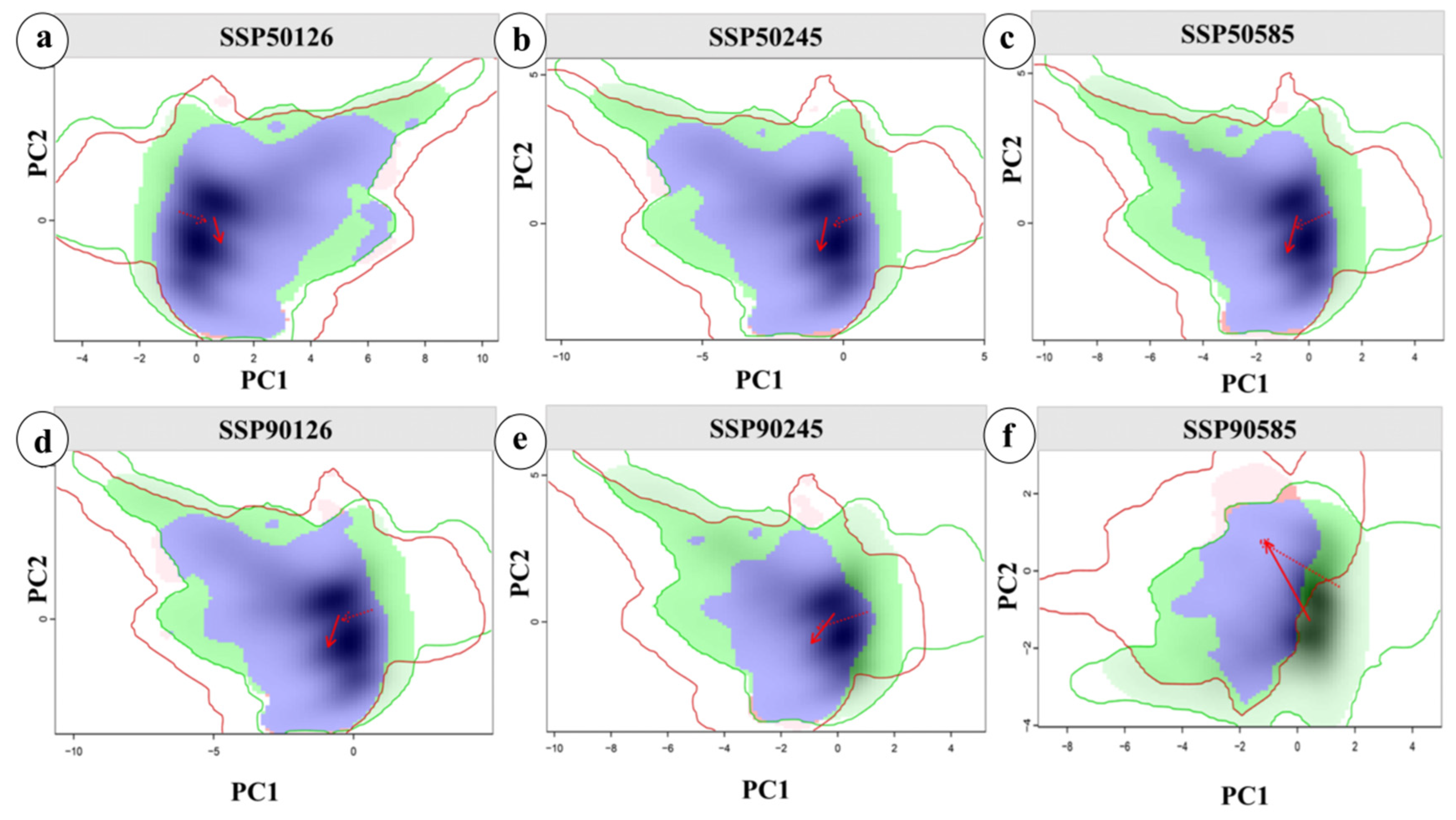
2.5. Analysis of Niche Changes in Future Periods

This study quantitatively analyzed the niche differentiation and environmental drivers of P. aquilinum var. latiusculum in the upper Dadu River–Min River basin under three emission scenarios (SSP1-2.6, SSP2-4.5, and SSP5-8.5) for 2050 and 2090. Using distribution points and climate data under different climate backgrounds, the ecospat package was employed to calculate niche overlap rates and visualize niche changes for important wild herbivorous resources in the study area (Figure 5). As shown in Figure 5, changes in climatic niches under current and future climate conditions align with background climate trends. The niche overlap rate of P. aquilinum var. latiusculum significantly decreased under the SSP5-8.5 scenario, with D values of 0.427 in the 2050s and 0.307 in the 2090s, indicating intensified niche differentiation under high-emission scenarios and potential migration to higher-altitude regions. Principal component analysis (PCA) showed that the first two principal components explained 68.69–72.10% of the variance in environmental factors (PC1: 51.53–53.31%; PC2: 17.16–18.79%). The coefficients of variation in temperature seasonality, the annual temperature range, and the minimum temperature of the coldest month identified these as the primary drivers of niche changes. The future climatic niche center will shift toward areas with higher annual temperature ranges and temperature seasonality coefficients.

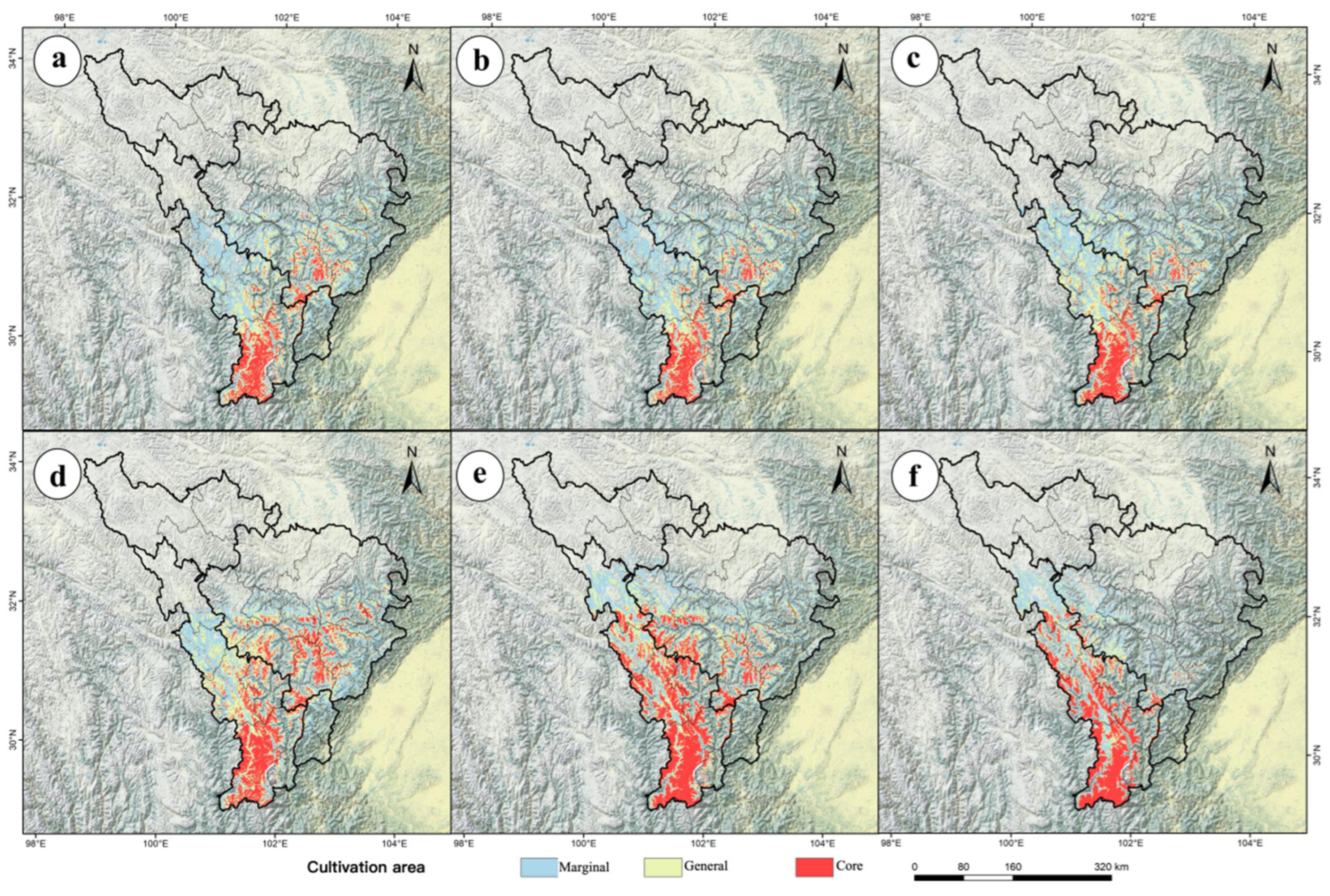
2.6. Delineation of Potential Cultivation Areas for P. aquilinum var. latiusculum in Different Periods

According to the Akaike Information Criterion (AIC), among the seven linear models, the linear model shown in Figure S3c was identified as the optimal model for this study. Figure S3 illustrates a significant positive correlation between habitat suitability and productivity for P. aquilinum var. latiusculum.
Based on the production dynamics model, productivity was categorized into three levels: high productivity (>0.58), medium productivity (0.37–0.58), and low productivity (<0.37). High-productivity areas were designated as core cultivation zones, medium-productivity areas as general cultivation zones, and low-productivity areas as marginal cultivation zones (Figure 6).
Under current climate conditions, the total cultivation area is 6.12 × 10⁴ km2, including 0.24 × 10⁴ km2 of core cultivation zones and 2.68 × 10⁴ km2 of general cultivation zones (Table 3). Current cultivation areas for P. aquilinum var. latiusculum are primarily concentrated in the entire upper Min River basin and parts of Kangding City, Daofu County, and Danba County in the upper Dadu River basin. Core cultivation zones are predominantly distributed in patchy, fragmented patterns across Tianquan County, Kangding City, Wenchuan County, Xiaojin County, Li County, Mao County, and Heishui County (Figure 2c).
Quantitative analysis of spatiotemporal changes in cultivation areas under different Shared Socioeconomic Pathways (SSPs) (Figure 6) revealed significant shifts across the three cultivation zones compared to the current period. The results show that as time progresses or the intensity of the emission pathway increases, the total cultivation area of P. aquilinum var. latiusculum exhibits a contraction trend, with core cultivation areas increasing, general cultivation areas fluctuating, and marginal cultivation areas decreasing (Figure 6, Table 3). Climate change induces a northward migration of cultivation areas toward higher latitudes, with core cultivation zones gradually shifting to Kangding City, Danba County, and Daofu County in the upper Dadu River basin (Figure 6). This indicates that under climate change, a large portion of unsuitable areas in the upper Dadu River basin may transform into general or marginal cultivation zones, and even some general/marginal zones could become core cultivation areas. Conversely, many general and marginal cultivation zones in the upper Min River basin may turn unsuitable, with some general/core zones degrading to marginal status (Figure 6). These complex responses highlight that species adaptation to climate change is nonlinear, underscoring the need for adaptive management strategies for P. aquilinum var. latiusculum in the future.

3. Discussion

3.1. The Significance of Conducting Distribution Modeling for P. aquilinum var. latiusculum

P. aquilinum var. latiusculum, a traditionally harvested wild vegetable for residents in the upper Dadu River–Min River basin, serves not only as a supplement to food security in alpine regions, but also as a vital source of nutritional health and economic income [35]. This wild vegetable is renowned for its high nutritional value and medicinal potential [27,29,30,31,32,33]. The biological characteristics and utilization history of P. aquilinum var. latiusculum in the study area are detailed in Text S2. Field surveys indicate that locals highly favor P. aquilinum var. latiusculum for its perceived efficacy in reducing phlegm, clearing heat, and calming the mind. The annual collection volume in the upper Min River basin reaches 500 tons, generating an average annual income of CNY 2000 per household. Therefore, understanding changes in its potential distribution and cultivation areas under climate change is crucial for its sustainable utilization in this region. To quantify the potential impacts of climate change on the distribution of P. aquilinum var. latiusculum, this study implemented a four-phase analytical framework. Set in the context of the upper reaches of the Dadu River–Minjiang River, and focusing on P. aquilinum var. latiusculum, the research first involved conducting a comparative analysis of 12 common SDMs. Optimal SDMs for the study area were screened via three evaluation metrics. Secondly, environmental variables for modeling were preselected based on collinearity analysis. Thirdly, the optimal SDM was applied to these variables to derive the current and future potential distribution areas, niche change trends, and habitat centroid migration trajectories of P. aquilinum var. latiusculum. Fourthly, a production dynamics model was constructed using standardized nutritional composition data of P. aquilinum var. latiusculum to explore its current and future potential natural cultivation regions.

3.2. Advantages of Using Ensemble Models in This Study

Niche models utilize known species distribution data and environmental variables to deduce ecological requirements via algorithms, projecting results onto corresponding spatiotemporal regions to simulate actual and potential distributions [39]. Recent studies highlight limitations of single-species distribution models like discriminant analysis or support vector machines, including overfitting, high uncertainty, and data-type dependencies [40,41]. Ensemble models integrate multiple single models to combine their strengths, separate output uncertainties and errors, and map primary trends, thereby mitigating these limitations [40,42]. In this study, the ensemble model was constructed using top-performing single models based on predictive results and evaluation metrics. With mean values of 0.972 for TSS, 0.998 for ROC, and 0.950 for KAPPA, the ensemble model outperformed single models in both scoring and prediction accuracy. This indicates that ensemble models leverage complementarity among single models to reduce bias and uncertainty, yielding more reliable predictions. Notably, the suitable habitats predicted for P. aquilinum var. latiusculum in the study area align with distribution heatmaps from iPlant (https://www.iplant.cn accessed on 1 April 2025), and the field survey records fall within predicted suitable habitats, further validating the model’s accuracy.

3.3. Impacts of Climate Change on P. aquilinum var. latiusculum

Climate change may accelerate species extinction, reduce biodiversity, and weaken regional ecosystems, though some species may develop new physiological traits to adapt [43,44]. Over recent decades, global climate and environmental change research has gained increasing scientific prominence [1,21,23]. Based on environmental factors under three emission scenarios for 2050 and 2090, combined with current climate data, this study predicted the potential geographic distribution of P. aquilinum var. latiusculum. The results show that under climate change, the potential suitable habitats and cultivation areas generally decline in the upper Dadu River–Min River basin, while high-suitability areas and primary cultivation zones increase drastically. Pauli et al. [45] documented a “mountain-top trap effect” in alpine ecosystems under climate warming, where suitable plant habitats become constrained by summit boundaries. Similarly, P. aquilinum var. latiusculum in alpine regions faces this effect. Thomas et al.’s research on extinction risks in 20% of global sample areas showed bidirectional impacts of climate warming on species distributions, with neither a risk of universal extinction nor benefits [3]. Parmesan and Yohe [46] noted that climate change may expand the ranges of some species while shrinking those of others, highlighting its dual role as a double-edged sword. For P. aquilinum var. latiusculum in alpine ecosystems, climate warming induces a polarized pattern, with moderate/low-suitability habitats and low-quality cultivation areas decreasing. In contrast, high-suitability habitats and high-quality cultivation areas increase, rather than a simple linear response occurring.
Regarding niche dynamics, P. aquilinum var. latiusculum showed decreasing niche overlap between current and future scenarios as climate change intensity increased. The coefficient of variation in temperature seasonality, annual temperature range, and minimum temperature of the coldest month were identified as the primary drivers of niche differentiation (Supplementary Table S1), consistent with the biological characteristics described by Wang [27] and Thepsilvisut et al. [29]. Bai et al. [47] showed that the budding rate and stem emergence period of P. aquilinum var. latiusculum vary significantly under different environmental conditions. Excessive temperature differences or extremely low temperatures can dramatically affect the yield and distribution of P. aquilinum var. latiusculum, further validating the accuracy of this study. Rapid temperature changes in high-altitude regions like Tibet and Qinghai [48,49] significantly impact the upper Dadu River–Min River basin, located at the eastern edge of the Qinghai–Tibet Plateau [34], and its flora.
The northward or upward migration of plant habitat centroids under climate change is well-documented. Parmesan and Yohe [46] found that 80% of species migrated poleward or to higher altitudes due to warming, with temperate plants showing particularly strong responses. This pattern is validated across Eurasian ecosystems: Chen et al. [48] observed the northward expansion of European beech (Fagus sylvatica) into Scandinavia at 30–50 km per decade, driven by reduced winter cold constraints. Lenoir et al. [50] reported a 29 m per decade upward shift in plant communities across six European mountain ranges, correlated with regional warming rates. In East Asia, Zhu et al. [51] found that 53% of Chinese plant species shifted their climatic niches northward, with alpine/subalpine species in the Hengduan Mountains migrating at a rate of 11 km per decade—faster than low-altitude species—confirming differential climate impacts on mountain ecosystems. The northward and northeastward shift of P. aquilinum var. latiusculum’s potential habitats in this study aligns with the “climate-driven niche shift” mechanism, supporting the latitude adaptation strategy of Northern Hemisphere plants to warming. The upper reaches of the Dadu River and Minjiang River represent the forest-steppe ecotone of the Qinghai–Tibet Plateau [33,34,35]. This study reveals that the niche of P. aquilinum var. latiusculum is shifting from the current forest-steppe ecotone to high-altitude grasslands, with a more pronounced migration under high-carbon emission scenarios compared to low-carbon ones. The stability of grassland ecosystems is far lower than that of forest and shrub ecosystems [52]. Therefore, the large-scale development and utilization of P. aquilinum var. latiusculum in grassland ecosystems would undoubtedly pose a significant challenge to grassland ecological stability and biodiversity. Thus, future development and utilization of P. aquilinum var. latiusculum in the upper reaches of the Dadu River–Minjiang River should consider its potential migration to high-altitude grasslands under climate change.

3.4. Adaptive Management of P. aquilinum var. latiusculum Under Climate Warming

The predicted increase in suitable areas for P. aquilinum var. latiusculum under climate change offers opportunities for sustainable resource use. The suitability–productivity model developed here delineates potential cultivation zones, providing a scientific basis for future management. Current cultivation areas are concentrated in the upper Min River basin and in the Kangding, Daofu, and Danba Counties in the upper Dadu River basin (Figure 2c), where the hydrothermal conditions match the plants ecological needs. Under the SSP5-8.5 scenario, core cultivation areas are expected to expand to higher altitudes and latitudes by 2090 (Figure 5), suggesting that climate change may enable large-scale cultivation while posing management challenges. As a dual-purpose food–medicine plant [27,29], the predicted expansion of core cultivation areas could facilitate artificial cultivation as an alternative to wild harvesting.
Based on the region’s unique climate, three recommendations are proposed for the sustainable utilization of P. aquilinum var. latiusculum: (1) Enhance awareness and promote rational exploitation: Increase surveys of wild vegetable resources like P. aquilinum var. latiusculum to understand their efficacy, distribution, and growth patterns. Adopt a “utilization–protection balance” to ensure ecological sustainability and income growth for local communities. (2) Strengthen systematic research and scientific utilization: Invest in cultivar development through nutritional and health efficacy studies. Develop key cultivation technologies to increase commercial yields and meet growing consumer demand. (3) Amplify promotion and encourage integration with wellness industries: Leverage the region’s status as a core area of the Tibetan–Qiang–Yi Cultural Industry Corridor (State Council Bulletin, https://www.gov.cn accessed on 5 April 2025). Promote wild vegetable products alongside wellness tourism to boost local economies and public health. Prioritize standardized cultivation in current core zones and adopt adaptive management strategies that incorporate dynamic adjustments to cultivation zones.

3.5. Research Prospects

This study provides a macro-planning foundation for the sustainable management of P. aquilinum var. latiusculum resources in alpine valley areas under climate change scenarios, but several aspects require further refinement. First, although the Human Footprint Index was incorporated into the modeling, its contribution rate was not fully quantified due to the spatial characteristic of overall low human activity intensity in the study area. In the future, there is an urgent need to integrate high-spatiotemporal-resolution dynamic data on human activities to construct a “climate–human dual-driving model” for the precise assessment of picking pressure and land use competition effects in hotspot regions, such as Wenchuan County and Kangding City. Second, the synergistic effects of multidimensional influencing mechanisms need to be systematically analyzed. This involves coupling land use change models to simulate habitat fragmentation processes, incorporating community-level socioeconomic driving factors, and quantifying the competition coefficients between P. aquilinum var. latiusculum and associated plants through field control experiments to improve niche dynamic predictions. Given the inherent unpredictability of future variables, practical applications must comprehensively evaluate these confounding factors within adaptive management frameworks to ensure effective decision-making.

4. Materials and Methods

4.1. Sample Collection and Species Distribution Records

From July 2022 to May 2024, our research team conducted field surveys across the potential distribution areas of P. aquilinum var. latiusculum in the upper Dadu River–Min River basin, which yielded 256 validated occurrence records. Using the subset and clean_coordinates functions in the R package CoordinateCleaner(V2.0), we corrected spatial biases in the dataset by retaining only one occurrence point per 1 km × 1 km grid cell. This process resulted in 176 high-quality occurrence points (Figure 2d) [53].

4.2. Selection and Processing of Environmental Variables

A total of 41 environmental variables were initially considered, including 19 bioclimatic factors, 16 soil properties, 3 topographic variables, 1 Human Footprint Index, 1 land use type, and 1 Normalized Difference Vegetation Index (NDVI). Current and future climate data were downloaded from the WorldClim database (http://worldclim.org/data/index.html accessed on 1 August 2023) under three Shared Socioeconomic Pathways (SSP1-2.6, SSP2-4.5, and SSP5-8.5), representing scenarios of low, medium, and high greenhouse gas emissions, respectively. Soil and topographic data were sourced from the Harmonized World Soil Database (HWSD) of the Food and Agriculture Organization (FAO) (http://www.fao.org/faostat/en/#data accessed on 1 August 2023). The Human Footprint Index 2009, derived from eight variables (built environments, population density, electrical infrastructure, cropland, pasture, roads, railways, and navigable waterways), was compiled by the NASA Socioeconomic Data and Applications Center (SEDAC). NDVI data, calculated as the difference between near-infrared and red reflectance, were provided by the Land Processes Distributed Active Archive Center (LPDAAC) at the U.S. Geological Survey’s Earth Resources Observation and Science (EROS) Center (http://LPDAAC.usgs.gov accessed on 1 August 2023). Land use data were acquired from the Resource and Environment Data Cloud Platform of the Chinese Academy of Sciences (http://www.resdc.cn/Default.aspx accessed on 1 August 2023).
To mitigate multicollinearity and overfitting in model predictions, we performed variable screening using variance inflation factor (VIF) analysis, principal component analysis (PCA), and Spearman’s correlation tests in R [16]. Variables were retained if they met the following criteria: (1) a pairwise Spearman correlation coefficient < 0.7, (2) VIF < 5, and (3) higher ecological relevance for Pteridium aquilinum var. latiusculum. This process resulted in the selection of 16 environmental variables (Table S1).

4.3. Ensemble Model Construction

Biomod2 was used to develop an ensemble model based on species distribution data and pseudo-absence points. The package generates non-occurrence data (pseudo-absences) from background environmental data using predefined methods. The random command was employed to create 1200 pseudo-absence points for model simulation. The biomod_tuning function optimized model parameters and selected 75% of the dataset for training, with the remaining 25% reserved for validation. Equal weights were assigned to occurrence and pseudo-absence data, and the process was repeated 10 times to produce 100 model simulations. Model accuracy was evaluated using the Receiver Operating Characteristic (ROC), Kappa, and True Skill Statistic (TSS). Single models with TSS ≥ 0.7 were retained, and a weighted average method was applied to construct the ensemble model [10]. A binary threshold (cutoff) of 0/1 was derived from model outputs, where areas below the threshold were classified as unsuitable. Regions above the threshold were divided into three equal suitability tiers: low, moderate, and high. The final classifications were visualized in ArcGIS v10.4.1.

4.4. Niche Dynamics Analysis

For current climate conditions, the background point selection area for Pteridium aquilinum var. latiusculum was defined by a 1-degree buffer around known distribution points. Under future climate scenarios, background areas were delineated using ensemble-modeled suitable habitats. Niche overlap between current and future climates was calculated using the ecospat package, which visualized niche shifts and quantified the D statistic (range: 0–1), where 0 indicates no overlap and 1 signifies complete overlap [13,23]. This assessed the impacts of climate change on species niche dynamics.

4.5. Centroid Migration Trajectory

Using the SDMTool package (v1.1-21) in R, centroid coordinates of suitable habitats were calculated for different periods and climate scenarios. Longitude/latitude values and migration distances between centroids were computed in ArcGIS, and trajectory visualizations were generated to illustrate centroid shifts.

4.6. Establishing Cultivation Productivity–Suitability Relationships

This study employed food science methods to determine the nutritional components (conventional nutrients, bioactive compounds, and amino acid profiles) of P. aquilinum var. latiusculum across 36 randomly selected distribution sites. An assessment model integrating ecological suitability and nutritional components was developed to evaluate the cultivation productivity of P. aquilinum var. latiusculum. The assessment model is presented below.
P = S + N
To evaluate the relationship between the cultivation productivity and environmental suitability of P. aquilinum var. latiusculum, the ecological suitability value (S) was derived from the presence probability values output by the species distribution model, with suitability data for each cultivation area extracted via spatial interpolation and weighted accordingly. Nutritional components (N) had their indicator weights determined by the entropy weight method. The types of P. aquilinum var. latiusculum nutritional components, weight ratios, and rationales are detailed in Text S1 and Table S4. After standardizing each indicator (Table S2) [54], a weighted summation was performed using the following formula:
N = i = 1 4 w i · X i n o r m
Model validation utilized the ggtrendline package in R (v4.1.2) to fit quantitative relationships between cultivation productivity and ecological suitability using seven types of nonlinear regression models (Table S3) [53]. The optimal model was selected based on the Akaike Information Criterion (AIC), with ΔAIC < 2. The potential cultivation areas of P. aquilinum var. latiusculum under current and future climate conditions were then predicted using this optimal model [55].

5. Conclusions

This study employed an ensemble modeling approach to systematically evaluate the impacts of climate change on the potential distribution and cultivation areas of P. aquilinum var. latiusculum in the upper Dadu River–Min River basin, revealing complex response mechanisms in its suitable habitats and cultivation patterns. The results indicate that current high-suitability areas and core cultivation zones for P. aquilinum var. latiusculum are fragmented across low-altitude river valleys, such as those in the Wenchuan and Li Counties. Under climate warming, both potential distribution and cultivation areas exhibit a polarized pattern of “expansion in high-quality zones and contraction in moderate/low-quality zones,” accompanied by gradual shifts in climatic niches. Adaptive management strategies are recommended for sustainable utilization, involving the standardization of cultivation practices in existing core zones to meet market demands while dynamically adjusting cultivation areas in response to changing climate suitability. This research not only provides decision-making support for the sustainable use of P. aquilinum var. latiusculum resources, but also offers insights for biodiversity conservation and livelihood adaptation in alpine valley regions under global change.

Supplementary Materials

The following supporting information can be downloaded at https://www.mdpi.com/article/10.3390/plants14142123/s1: Figure S1: (a) Field habitat of P. aquilinum var. latiusculum; (b–d) Three processing and consumption methods of P. aquilinum var. latiusculum: (b) Blanched and served with cold dressing; (c) Blanched and stir-fried with meat; (d) Dried, blanched, and served with cold dressing; Figure S2: Potential distribution of P. aquilinum var. latiusculum in the upper Dadu River–Minjiang River basin based on multi-model predictions: (a) ANN model, (b) GTA model, (c) FDA model, (d) GAM model, (e) GBM model, (f) GLM model, (g) MARS model, (h) MaxEnt model, (i) RF model, (j) SER model, (k) XGBOOST model, (l) Ensemble model. Figure S3: Relationships between suitability and productivity for P. aquilinum var. latiusculum. (a) exp2P model, (b) exp3P model, (c) line2P model, (d) line3P model, (e) log2P model, (f) power2P model, (g) power3P model; Text S1: Nutritional Component Types, Weight Proportions, and Rationale for Setting Weights; Text S2: Biological Characteristics and Utilization History of P. aquilinum var. latiusculum in the Study Area. Table S1: 16 environmental variables involved in modeling; Table S2: Seven model types used for modeling the relationship between productivity and suitability; Table S3: Standardized results of various indicators for P. aquilinum var. Latiusculum; Table S4: Types of Nutritional Components and Assigned Weight Proportions for P. aquilinum var. Latiusculum.

Author Contributions

Conceptualization, Y.H. and J.Y. (Jingtian Yang); methodology, J.Y. (Jingtian Yang); software, Y.H.; validation, J.Y. (Jingtian Yang) and G.Z.; formal analysis, Y.H. and Q.G.; investigation, Y.H.; resources, Y.Y.; data curation, Y.H. and J.Y. (Jingtian Yang); writing—original draft preparation, Y.H. and Z.S.; writing—review and editing, J.Y. (Jian Yang); visualization, J.Y. (Jian Yang); supervision, Y.H. and G.Z.; project administration, J.Y. (Jian Yang); funding acquisition, J.Y. (Jian Yang). All authors have read and agreed to the published version of the manuscript.

Funding

This work was funded by the Project of Grassland Multifunctionality Evaluation in Three-River-Source National Park (QHQXD-2023-28), the Southwest Minzu University Research Startup Funds (Grant No. RQD2022046). The WeiZhou Team Funds, Southwest Minzu University (Grant No. SMUWZ202410). Innovation Team for Alpine Grassland Ecological Protection Research on the Qinghai—Tibetan Plateau, Southwest Minzu University (SMUWZ202410, 2024CXTD01).

Institutional Review Board Statement

Not applicable.

Informed Consent Statement

Not applicable.

Data Availability Statement

Data will be made available on request.

Acknowledgments

We are grateful to the editors and anonymous reviewers for their valuable comments.

Conflicts of Interest

The authors declare no conflicts of interest.

References

  1. Wan, J.N.; Wang, S.W.; Leitch, A.R.; Leitch, I.J.; Jian, J.B.; Wu, Z.Y.; Xin, H.P.; Rakotoarinivo, M.; Onjalalaina, G.E.; Gituru, R.W.; et al. The Rise of Baobab Trees in Madagascar. Nature 2024, 629, 1091–1099. [Google Scholar] [CrossRef] [PubMed]
  2. Mi, C.; Ma, L.; Yang, M.; Li, X.; Meiri, S.; Roll, U.; Oskyrko, O.; Pincheira-Donoso, D.; Harvey, L.P.; Jablonski, D.; et al. Global Protected Areas as Refuges for Amphibians and Reptiles under Climate Change. Nat. Commun. 2023, 14, 1389. [Google Scholar] [CrossRef] [PubMed]
  3. Thomas, C.D.; Cameron, A.; Green, R.E.; Bakkenes, M.; Beaumont, L.J.; Collingham, Y.C.; Erasmus, B.F.N.; de Siqueira, M.F.; Grainger, A.; Hannah, L.; et al. Extinction Risk from Climate Change. Nature 2004, 427, 145–148. [Google Scholar] [CrossRef] [PubMed]
  4. Chen, F.H.; Dong, G.H.; Zhang, D.J.; Liu, X.Y.; Jia, X.; An, C.B.; Ma, M.M.; Xie, Y.W.; Barton, L.; Ren, X.Y.; et al. Agriculture Facilitated Permanent Human Occupation of the Tibetan Plateau after 3600 B.P. Science 2015, 347, 248–250. [Google Scholar] [CrossRef]
  5. Avasthi, A. California Tries to Connect Its Scattered Marine Reserves. Science 2005, 308, 487–488. [Google Scholar] [CrossRef] [PubMed]
  6. Brooks, T.M.; Mittermeier, R.A.; da Fonseca, G.A.B.; Gerlach, J.; Hoffmann, M.; Lamoreux, J.F.; Mittermeier, C.G.; Pilgrim, J.D.; Rodrigues, A.S.L. Global Biodiversity Conservation Priorities. Science 2006, 313, 58–61. [Google Scholar] [CrossRef] [PubMed]
  7. Teixidor-Toneu, I.; Jordan, F.M.; Hawkins, J.A. Comparative Phylogenetic Methods and the Cultural Evolution of Medicinal Plant Use. Nat. Plants 2018, 4, 754–761. [Google Scholar] [CrossRef] [PubMed]
  8. Cantwell-Jones, A.; Ball, J.; Collar, D.; Diazgranados, M.; Douglas, R.; Forest, F.; Hawkins, J.; Howes, M.-J.R.; Ulian, T.; Vaitla, B.; et al. Global Plant Diversity as a Reservoir of Micronutrients for Humanity. Nat. Plants 2022, 8, 225–232. [Google Scholar] [CrossRef]
  9. Cheng, Z.; Lu, X.; Hu, X.; Zhang, Q.; Ali, M.; Long, C. Dulong People’s Traditional Knowledge of Caryota obtusa (Arecaceae): A Potential Starch Plant with Emphasis on Its Starch Properties and Distribution Prediction. Econ. Bot. 2023, 77, 63–81. [Google Scholar] [CrossRef]
  10. Cheng, Z.; Lu, X.; Lin, F.; Naeem, A.; Long, C. Ethnobotanical Study on Wild Edible Plants Used by Dulong People in Northwestern Yunnan, China. J. Ethnobiol. Ethnomed. 2022, 18, 3. [Google Scholar] [CrossRef]
  11. Pan, Y.; Guan, Y.; Lv, S.; Huang, X.; Lin, Y.; Wei, C.; Xu, D. Assessing the Potential Distribution of Lonicera Japonica in China Under Climate Change: A Biomod2 Ensemble Model-Based Study. Agriculture 2025, 15, 393. [Google Scholar] [CrossRef]
  12. Yu, H.; Zhuo, Z.; He, Z.; Liu, Q.; Deng, X.; Xu, D. Distribution of Trachelospermum Jasminoides Under the Influence of Different Environmental Factors. Agriculture 2025, 15, 285. [Google Scholar] [CrossRef]
  13. Wen, X.; Fang, G.; Chai, S.; He, C.; Sun, S.; Zhao, G.; Lin, X. Can Ecological Niche Models Be Used to Accurately Predict the Distribution of Invasive Insects? A Case Study of Hyphantria cunea in China. Ecol. Evol. 2024, 14, e11159. [Google Scholar] [CrossRef]
  14. Zhan, P.; Wang, F.; Xia, P.; Zhao, G.; Wei, M.; Wei, F.; Han, R. Assessment of Suitable Cultivation Region for Panax Notoginseng under Different Climatic Conditions Using MaxEnt Model and High-Performance Liquid Chromatography in China. Ind. Crops Prod. 2022, 176, 114416. [Google Scholar] [CrossRef]
  15. Chen, C.; Xiao, W.; Chen, H.Y.H. Meta-Analysis Reveals Global Variations in Plant Diversity Effects on Productivity. Nature 2025, 638, 435–440. [Google Scholar] [CrossRef] [PubMed]
  16. Zhao, G.; Cui, X.; Sun, J.; Li, T.; Wang, Q.; Ye, X.; Fan, B. Analysis of the Distribution Pattern of Chinese Ziziphus jujuba under Climate Change Based on Optimized Biomod2 and MaxEnt Models. Ecol. Indic. 2021, 132, 108256. [Google Scholar] [CrossRef]
  17. Yang, J.; Huang, Y.; Jiang, X.; Chen, H.; Liu, M.; Wang, R. Potential Geographical Distribution of the Edangred Plant Isoetes under Human Activities Using MaxEnt and GARP. Glob. Ecol. Conserv. 2022, 38, e02186. [Google Scholar] [CrossRef]
  18. Guisan, A.; Thuiller, W. Predicting Species Distribution: Offering More than Simple Habitat Models. Ecol. Lett. 2005, 8, 993–1009. [Google Scholar] [CrossRef] [PubMed]
  19. Thuiller, W.; Lafourcade, B.; Engler, R.; Araújo, M.B. BIOMOD–a Platform for Ensemble Forecasting of Species Distributions. Ecography 2009, 32, 369–373. [Google Scholar] [CrossRef]
  20. Wang, Y.; Zhao, R.; Zhou, X.; Zhang, X.; Zhao, G.; Zhang, F. Prediction of Potential Distribution Areas and Priority Protected Areas of Agastache Rugosa Based on Maxent Model and Marxan Model. Front. Plant Sci. 2023, 14, 1200796. [Google Scholar] [CrossRef]
  21. Huang, Y.; Zeng, Y.; Jiang, P.; Chen, H.; Yang, J. Prediction of Potential Geographic Distribution of Endangered Relict Tree Species Dipteronia Sinensis in China Based on MaxEnt and GIS. Pol. J. Environ. Stud. 2022, 31, 3597–3609. [Google Scholar] [CrossRef]
  22. Liu, L.; Liang, S.; Xie, C.; Liu, J.; Zheng, Y.; Xue, J. Predicting the Potential Distribution of Aralia chinensis L.(Wild Vegetable) in China Under Different Climate Change Scenarios. Biology 2024, 13, 937. [Google Scholar] [CrossRef]
  23. Liu, M.; Li, X.; Yang, L.; Chen, K.; Shama, Z.; Jiang, X.; Yang, J.; Zhao, G.; Huang, Y. Prediction of the Potential Distribution and Conservation Strategies of the Endangered Plant Tapiscia sinensis. Forests 2024, 15, 1677. [Google Scholar] [CrossRef]
  24. Xie, C.; Chen, L.; Li, M.; Jim, C.Y.; Liu, D. BIOCLIM Modeling for Predicting Suitable Habitat for Endangered Tree Tapiscia sinensis (Tapisciaceae) in China. Forests 2023, 14, 2275. [Google Scholar] [CrossRef]
  25. Hao, T.; Elith, J.; Guillera-Arroita, G.; Lahoz-Monfort, J.J. A Review of Evidence about Use and Performance of Species Distribution Modelling Ensembles like BIOMOD. Divers. Distrib. 2019, 25, 839–852. [Google Scholar] [CrossRef]
  26. Wen, X.; Zhao, G.; Cheng, X.; Chang, G.; Dong, X.; Lin, X. Prediction of the Potential Distribution Pattern of the Great Gerbil (Rhombomys opimus) under Climate Change Based on Ensemble Modelling. Pest Manag. Sci. 2022, 78, 3128–3134. [Google Scholar] [CrossRef] [PubMed]
  27. Wang, J. Extraction, Activity Analysis of Flavonoids from Pteridium aquilinum var. latiusculum and Their Effects on Storage Quality of Pteridium aquilinum var. latiusculum Filling. Master’s Thesis, Northeast Agricultural University, Harbin, China, 2024. [Google Scholar]
  28. Zimeng, F.; Xiang, H.; Shuangli, L.; Xiaohui, W. Antidepressant-like Effects of Flavonoids from Pteridium aquilinum var. latiusculum. Med. Plant 2023, 14, 55. [Google Scholar] [CrossRef]
  29. Thepsilvisut, O.; Iad-Ak, R.; Chutimanukul, P. The Effects of Shading and Nutrient Management on Yield Quality of Vegetable Fern. Horticulturae 2023, 9, 259. [Google Scholar] [CrossRef]
  30. Reddy, M.N.; Adnan, M.; Alreshidi, M.M.; Saeed, M.; Patel, M. Evaluation of Anticancer, Antibacterial and Antioxidant Properties of a Medicinally Treasured Fern Tectaria coadunata with Its Phytoconstituents Analysis by HR-LCMS. Anti-Cancer Agents Med. Chem. 2020, 20, 1845–1856. [Google Scholar] [CrossRef]
  31. Hao, J.; Fan, X.; Chen, N.; Wang, Y.; Xiao, J.; Zhang, M. A Novel Method for the Simultaneous Determination of Flavonoids in Pteridium aquilinum via SPE Combined with UPLC-DAD via QAMS. J. Food Compos. Anal. 2025, 137, 106881. [Google Scholar] [CrossRef]
  32. Adebayo, O.T.; Oluremi, B.B.; Ogunlakin, A.D.; Gyebi, G.A.; Sonibare, M.A. Pharmacognostic Evaluation and Antimicrobial Activity of Pteridium aquilinum (L.) Kuhn Leaves (Onocleaceae) via in Vitro and in Silico Perspectives. PLoS ONE 2025, 20, e0318943. [Google Scholar] [CrossRef]
  33. Li, S.; Chen, N.; Bu, Y.; Hao, J.; Huang, H.; Zheng, S. Network Pharmacology Analysis of the Renal Protective Effects of the Bracken (Pteridium aquilinum) Using Experimental Data Obtained in an Avian (Quail) Hyperuricemia Model. Int. J. Clin. Pharmacol. Ther. 2024, 62, 178–193. [Google Scholar] [PubMed]
  34. Huang, Y.; Zhao, G.; Yang, J.; Yang, L.; Yang, Y.; Jiaba, W.; Shama, Z.; Yang, J. Evolution of Potential Distribution Areas and Cultivation Zones of Morchella esculenta (L.) Pers. Under Climate Warming: Application of Ensemble Models and Production Dynamics Models. J. Fungi 2025, 11, 475. [Google Scholar]
  35. Huang, Y.; Yang, J.; Zhao, G.; Yang, Y. Potential Distribution and Cultivation Areas of Argentina anserina (Rosaceae) in the Upper Reaches of the Dadu River and Minjiang River Basin Under Climate Change: Applications of Ensemble and Productivity Dynamic Models. Biology 2025, 14, 668. [Google Scholar] [CrossRef]
  36. Liu, M.; Su, M.M.; Cai, K.; Qi, P.S.; Gong, W.; Chen, D.-C.; He, L.; Wu, H.W.; Deng, D.Z.; Huang, Y. Distributional Response of Paeonia decomposita to Climate Change and Conservation Strategies. Pol. J. Environ. Stud. 2025, 34, 3657–3669. [Google Scholar] [CrossRef]
  37. Liu, L.; Zhang, Y.; Huang, Y.; Zhang, J.; Mou, Q.; Qiu, J.; Wang, R.; Li, Y.; Zhang, D. Simulation of Potential Suitable Distribution of Original Species of Fritillariae Cirrhosae Bulbus in China under Climate Change Scenarios. Environ. Sci. Pollut. Res. 2022, 29, 22237–22250. [Google Scholar] [CrossRef]
  38. Ghorbani, J.; Cox, E.S.; Alday, J.G.; Santana, V.M.; Lee, H.; McAllister, H.A.; Pakeman, R.J.; Le Duc, M.G.; Marrs, R.H. What Happens When You Turn Weed Management off? A Long-Term Appraisal of the Effectiveness of Pteridium aquilinum (L.) Kuhn Control Treatments and the Role of Sheep Grazing. J. Environ. Manag. 2025, 374, 124111. [Google Scholar] [CrossRef]
  39. Allouche, O.; Tsoar, A.; Kadmon, R. Assessing the Accuracy of Species Distribution Models: Prevalence, Kappa and the True Skill Statistic (TSS). J. Appl. Ecol. 2006, 43, 1223–1232. [Google Scholar] [CrossRef]
  40. Araújo, M.B.; New, M. Ensemble Forecasting of Species Distributions. Trends Ecol. Evol. 2007, 22, 42–47. [Google Scholar] [CrossRef]
  41. Linderman, M.; Liu, J.; Qi, J.; An, L.; Ouyang, Z.; Yang, J.; Tan, Y. Using Artificial Neural Networks to Map the Spatial Distribution of Understorey Bamboo from Remote Sensing Data. Int. J. Remote Sens. 2004, 25, 1685–1700. [Google Scholar]
  42. Thuiller, W. BIOMOD–Optimizing Predictions of Species Distributions and Projecting Potential Future Shifts under Global Change. Glob. Change Biol. 2003, 9, 1353–1362. [Google Scholar] [CrossRef]
  43. Garcia, K.; Lasco, R.; Ines, A.; Lyon, B.; Pulhin, F. Predicting Geographic Distribution and Habitat Suitability Due to Climate Change of Selected Threatened Forest Tree Species in the Philippines. Appl. Geogr. 2013, 44, 12–22. [Google Scholar] [CrossRef]
  44. Carosi, A.; Ghetti, L.; Padula, R.; Lorenzoni, M. Population Status and Ecology of the Salmo Trutta Complex in an Italian River Basin under Multiple Anthropogenic Pressures. Ecol. Evol. 2020, 10, 7320–7333. [Google Scholar] [CrossRef]
  45. Pauli, H.; Gottfried, M.; Dullinger, S.; Abdaladze, O.; Akhalkatsi, M.; Alonso, J.L.B.; Coldea, G.; Dick, J.; Erschbamer, B.; Calzado, R.F.; et al. Recent Plant Diversity Changes on Europe’s Mountain Summits. Science 2012, 336, 353–355. [Google Scholar] [CrossRef] [PubMed]
  46. Parmesan, C.; Yohe, G. A Globally Coherent Fingerprint of Climate Change Impacts across Natural Systems. Nature 2003, 421, 37–42. [Google Scholar] [CrossRef]
  47. Bai, Y.; Han, Z.; Wang, L.; Lian, P. The influence of different cultivation environment conditions on the growth and yield of ferns. Shelter. For. Technol. 2019, 6, 19–20. [Google Scholar] [CrossRef]
  48. Chen, I.C.; Hill, J.K.; Ohlemüller, R.; Roy, D.B.; Thomas, C.D. Rapid Range Shifts of Species Associated with High Levels of Climate Warming. Science 2011, 333, 1024–1026. [Google Scholar] [CrossRef]
  49. Guo, B.; Zang, W.; Yang, F.; Han, B.; Chen, S.; Liu, Y.; Yang, X.; He, T.; Chen, X.; Liu, C.; et al. Spatial and Temporal Change Patterns of Net Primary Productivity and Its Response to Climate Change in the Qinghai-Tibet Plateau of China from 2000 to 2015. J. Arid Land 2020, 12, 1–17. [Google Scholar] [CrossRef]
  50. Lenoir, J.; Gégout, J.C.; Marquet, P.A.; de Ruffray, P.; Brisse, H. A Significant Upward Shift in Plant Species Optimum Elevation During the 20th Century. Science 2008, 320, 1768–1771. [Google Scholar] [CrossRef]
  51. Zhu, K.; Woodall, C.W.; Clark, J.S. Failure to Migrate: Lack of Tree Range Expansion in Response to Climate Change. Glob. Change Biol. 2012, 18, 1042–1052. [Google Scholar]
  52. Brandt, J.S.; Haynes, M.A.; Kuemmerle, T.; Waller, D.M.; Radeloff, V.C. Regime shift on the roof of the world: Alpine meadows converting to shrublands in the southern Himalayas. Biol. Conserv. 2013, 158, 116–127. [Google Scholar]
  53. Zizka, A.; Silvestro, D.; Andermann, T.; Azevedo, J.; Duarte Ritter, C.; Edler, D.; Farooq, H.; Herdean, A.; Ariza, M.; Scharn, R. CoordinateCleaner: Standardized Cleaning of Occurrence Records from Biological Collection Databases. Methods Ecol. Evol. 2019, 10, 744–751. [Google Scholar]
  54. Sun, J.; Jiao, W.; Wang, Q.; Wang, T.; Yang, H.; Jin, J.; Feng, H.; Guo, J.; Feng, L.; Xu, X.; et al. Potential Habitat and Productivity Loss of Populus Deltoides Industrial Forest Plantations Due to Global Warming. For. Ecol. Manag. 2021, 496, 119474. [Google Scholar] [CrossRef]
  55. Beier, P. Model Selection and Inference: A Practical Information-Theoretic Approach. J. Wildl. Manag. 2001, 65, 606–608. [Google Scholar] [CrossRef]
Figure 1. Evaluation of model accuracy using three metrics. (a) ROC; (b) KAPPA; (c) TSS.
Plants 14 02123 g001
Figure 2. (a) The current potential distribution of P. aquilinum var. latiusculum in the upper Dadu River–Min River basin; (b) the migration trajectory of the habitat centroid for P. aquilinum var. latiusculum in the upper Dadu River–Min River basin; (c) the current potential cultivation areas of P. aquilinum var. latiusculum in the upper Dadu River–Min River basin; (d) distribution records of P. aquilinum var. latiusculum in the upper Dadu River–Min River basin.
Plants 14 02123 g002
Figure 3. Changes in the potential geographic distribution of P. aquilinum var. latiusculum in the upper Dadu River–Min River basin under future climate change scenarios. Potential geographic distributions under different climate scenarios: SSP1-2.6 (a,d), SSP2-4.5 (b,e), and SSP5-8.5 (c,f). Potential geographic distributions in different periods: the 2050s (ac) and the 2090s (df).
Plants 14 02123 g003
Figure 4. Changes in the potential geographic distribution of P. aquilinum var. latiusculum in the upper Dadu River–Min River basin under climate change. Potential geographic distribution changes under different climate scenarios: SSP1-2.6 (a,d), SSP2-4.5 (b,e), and SSP5-8.5 (c,f). Changes in potential geographic distribution across different periods: the 2050s (ac) and the 2090s (df).
Plants 14 02123 g004
Figure 5. Niche changes in P. aquilinum var. latiusculum under climate change. Niche shifts under different climate scenarios: SSP1-2.6 (a,d), SSP2-4.5 (b,e), and SSP5-8.5 (c,f). Niche changes across different periods: the 2050s (ac) and the 2090s (df). Green and red shading indicate the density of species occurrence in current and future scenarios, respectively, with blue representing overlap. The solid and dashed lines denote 100% and 50% of available environmental space, respectively. The red arrows illustrate how the climatic niche centroid (solid line) and background range centroid (dashed line) shift between these ranges.
Plants 14 02123 g005
Figure 6. The distribution of the three-level cultivation zones for P. aquilinum var. latiusculum in the upper Dadu River–Min River basin under future climate scenarios. The three-level cultivation zones under different climate scenarios: SSP1-2.6 (a,d), SSP2-4.5 (b,e), and SSP5-8.5 (c,f). Cultivation zone changes across different periods: the 2050s (ac) and the 2090s (df).
Plants 14 02123 g006
Table 1. Potential suitable areas for P. aquilinum var. latiusculum in different periods (104 km2).
PeriodClimate ScenarioLow Suitability ZoneModerate Suitability ZoneHigh Suitability ZoneTotal Suitability Zone
Current 2.623.250.366.23
2050SSP1262.292.181.195.66
2050SSP2452.242.051.125.41
2050SSP5852.112.311.225.64
2090SSP1262.092.892.067.04
2090SSP2452.082.422.747.24
2090SSP5851.591.351.794.73
Table 2. Changes in suitable habitat areas for P. aquilinum var. latiusculum under climate change scenarios (104 km2).
PeriodClimate ScenarioHabitat AreaLossStableGain
2050SSP1265.662.044.191.48
2050SSP2455.412.293.941.47
2050SSP5855.642.623.612.03
2090SSP1267.041.824.412.63
2090SSP2457.242.553.683.56
2090SSP5854.734.082.152.58
Table 3. Areas of potential cultivation zones for P. aquilinum var. latiusculum in different periods (104 km2).
PeriodClimate ScenarioMarginal CultivationGeneral CultivationCore CultivationTotal Cultivation
Current 3.202.680.246.12
2050SSP1262.551.950.985.48
2050SSP2452.491.840.915.24
2050SSP5852.462.051.015.52
2090SSP1262.432.771.716.91
2090SSP2452.312.382.397.08
2090SSP5851.681.281.634.59
Disclaimer/Publisher’s Note: The statements, opinions and data contained in all publications are solely those of the individual author(s) and contributor(s) and not of MDPI and/or the editor(s). MDPI and/or the editor(s) disclaim responsibility for any injury to people or property resulting from any ideas, methods, instructions or products referred to in the content.

