1. Introduction
Hangzhou 杭州, located in southeast China (approximately 120 km southwest of Shanghai 上海), a cultural center of the Jiangnan 江南 region, was the former imperial capital (previously known as Lin’an Fu 臨安府, Lin’an Prefecture) in the Southern Song dynasty (1127–1279). It was also one of the most prominent pilgrimage destinations for the Buddhist and Daoist communities, and home to a robust popular religion. Hangzhou, as pointed out by Albert Welter, is the center for reimagining East Asian Buddhism—in that Indian Buddhism was translocated to Hangzhou and manifested in various ways. It was then recognized as a new homeland for Buddhism (
Welter 2022). In the Song dynasty, when Hangzhou was one of China’s largest international trading hubs, the trading network successfully spread Buddhism. Buddhist establishments can reflect this highly esteemed status of Buddhism in Hangzhou—since those establishments delineate the cultural landscape within a locality. Moreover, Buddhist sites are highly dependent on sociocultural phenomena that are capable of telling us much about society.
With the advent of the spatial turn in the field of humanities, numerous endeavors have been undertaken to collect data from religious sites in East Asia. The projects include the Buddhist Geographical Information System Project (BGIS, The University of Arizona), Atlas of Religion in China (ECAI, Berkeley), China Historical Geographic Information System (CHGIS, Harvard University), Buddhist Temples in Taiwan (Academia Sinica, Taiwan), Chinese Civilization in Time and Space (Academia Sinica, Taiwan), Buddhist Studies Authority Database Project (Dharma Drum Buddhist College, Taiwan), and Spatial Religion Information Network (Purdue University). Data collected in these repositories provides us with great potential to conduct further analysis on the sociocultural aspects of religion.
Although the data collected in these projects offers much insight, the collections are aimed at a nationwide-level scale rather than targeted at regional aspects. Studying religion by using the data of large-scale areas often prevents us from observing regional characteristics, such as how religion interacted with local factors—including but not limited to imperial and local powers, commercial activities, urbanization, etc. These regional features can be best investigated in Hangzhou, for it is a political, economic, and religious epicenter in the Southern Song dynasty (it earned the appellation of
dongnan foguo 東南佛國, which means a southeastern Buddha land). Hangzhou, as stated by Jacques Gernet (1921–2018), was considered the richest and the most populated city in the world during this time period. (
Gernet 1962). This project uses the spatial data of Buddhist temples, drawn by Wu’s team from a Hangzhou local gazetteer titled the
Xianchun Lin’an zhi 咸淳臨安志 (
Records about Lin’an from the Xianchun Reign)—a 100-fascicle local chronicle that depicted the Lin’an Prefecture in the Southern Song dynasty, to create a visualization and conduct synchronic spatial analysis for all Buddhist establishments in the Southern Song. Our visualization and interpretation expect that we can observe how a religious landscape is portrayed when a given region was renowned as a political, cultural, and economic center at a given time—Hangzhou in the Southern Song in this case. Furthermore, by adapting GIS analysis to the temple distributions and corroborating the results with factual information (recorded in historical materials), including imperial power, urbanization, and commercial exchanges, we can highlight the interactions between Buddhism and sociopolitical factors that are not easily spotted via traditional textual approaches or using data that is scaled nationwide.
2. A Regional Approach to Religion
How should we proceed when investigating religion within a locality? Or perhaps a more important question, why should we focus on the aspect of religion at a regional rather than national level? As pointed out by Jiang Wu, the study of religious sites can be approached from the following three methodological perspectives: (1) a religious understanding of sacred space, (2) the geographical study of religion, and (3) a postmodern interpretation of social space (
Wu 2022). The common ground between the methods is regionalism in the study of religion—all of them address the notion of space, a delimited space dependent on the data being chosen. For instance, the
Xianchun Lin’an zhi axiomatically limits its regional boundaries within the Southern Song dynasty Lin’an (present-day Hangzhou) region. These boundaries confine the scope of the study within a locality (and a specific time frame) without significant digression. This regional approach is promoted by the Huanan School 華南學派 led by David Faure and Zheng Zhenman 鄭振滿, who believe that we should not acknowledge a region as a portion of a larger-scaled area and discuss its dynamics. Instead, a region should be examined as a whole to achieve a comprehensive understanding.
Wu claimed that this regional approach fuels the method of microhistory in Chinese regional studies, as it has the potential to reconstruct our understanding of historical and religious developments within a locality (
Wu and Wang 2021). Many scholars with their expertise in Chinese studies have advocated the approach of regionality from different perspectives. For William Rowe, a region means more than a zone with specific features within a larger state, but a locality system that should be studied on its own (
Rowe 1993). In Naito Konan’s 內藤湖南 (1866–1934) theory of the Tang–Song Transition 唐宋變革論, he pointed out that the advent of early modernity in China was fueled by social-intellectual changes that are better observed within a region (
Fogel 2003). For social linguists such as Willem Grootaers and Ray Iwata, dividing the whole study area into smaller grids or units is best for defining regional characteristics. (
Grootaers et al. 1995;
Iwata 2010).
Studying religious sites within a region is beneficial for investigating the complex dynamics between religion and the local community (commercial exchanges, urbanization, or state power vs. local power) because religious sites are one of the elements that construct the sociocultural landscape in China. As suggested by the religious theorist and anthropologist E. E. Evans-Pritchard (1902–1973), “They [religious facts] must be seen as a relation of parts to one another within a coherent system, each part making sense only in relation to the others, and the system itself making sense only in relation to other institutional systems, as part of a wider set of relations....” (
Pals 2009). Religious facts become meaningful only if they are accounted for in light of the totality of the culture and society in which they are found.
To exemplify religion in line with a regional coherent system, on the relation of religion with the administrative system, for instance, Albert Welter visualized the distribution of Buddhist stupas constructed by emperors of the Wuyue kingdom (907–978) within Hangzhou religion. He pointed out that this endeavor indicates the regime’s ambition to establish power and religious legitimacy in a region, hence forming a spatial pattern that is unique to this particular area (
Welter 2022). Moreover, on the relation between religion and the local socioeconomic system, Zhang Weiran mapped out the spatial structure of Guanyin pilgrimages in the Yangtze Delta. He discovered the spatial pattern of religious activities is related to economic nodes in local areas—pilgrimage activities brought about commercial exchanges such as trading in markets along the pilgrimage routes (
Zhang 2022). It thus indicates that religious institutions in China depend much on the local economy. The information on pilgrimage routes and trading markets is drawn by Zhang from a variety of historical sources, not only including poems, prose, newspapers, records, and novels; but mostly from local temple and official gazetteers, which indicates how resourceful gazetteers are when studying religion from a regional perspective.
3. Geoparsing Source of This Study, the Xianchun Lin’an zhi and Some References
One of the most inclusive sources of regional historiography is the genre of gazetteers, especially local gazetteers. Gazetteers (including officially commissioned, local, and private ones) are cumulative records within a locality, usually published in a book format, and arranged by topics such as topography, institutions, religion, population, taxes, economic exchanges, biographies, and literature (
Dennis 2015). The spectrum of gazetteer content is vast—it can be based on provinces, prefectures, counties, villages, temples, mountains, schools, and prominent figures. In terms of religion, gazetteers often dedicate sections that provide detailed descriptions focusing on religious venues, including temples, shrines, mountains, caves, etc., recorded in an entry-by-entry format similar to what a dictionary presents. The religious venues are usually named establishments, and gazetteers would tell us their names, date of establishment, location information, and some other peripheral information that the compiler felt necessary to record.
The primary source of the spatial data of Buddhist temples in this study is the
Xianchun Lin’an zhi, a local gazetteer of the Lin’an prefecture 臨安府 (Hangzhou, Zhejiang), which was the capital of the Southern Song dynasty (1127–1279 AC). It is a government-published gazetteer, compiled and supervised by a
zhifu 知府 (Lin’an prefect) Qian Shuoyou 潛說友 (1216–1277 AC). The
Xianchun Lin’an zhi and the two older gazetteers of the Song-dynasty Lin’an—the
Qiandao linanzhi 乾道臨安志 (Records about Lin’an from the Qiandao Reign, 1165–1173) and the
Chunyou linanzhi 淳祐臨安志 (Records about Lin’an from the Chunyou Reign, 1241–1252)—are the earliest existing local gazetteers of Hangzhou. Among the three Lin’an gazetteers from the Song period, the
Xianchun Lin’an zhi is the best in quality and preservation (
Lin 1990). Qian compiled a 100-fascicle-long
Xianchun Lin’an zhi (95 fascicles extant), an updated and expanded version based on the older two Lin’an gazetteers. The first 15 fascicles recorded the capital city and the seat of the imperial government, and the remaining fascicles (fascicles 16–100) documented the surroundings of the capital city, with detailed information on topography, literary works, customs, local products, eminent persons, temples, and shrines. The
Xianchun Lin’an zhi is a rich source for studying the history of Hangzhou, and it inspired later texts such as the
Menglianglu 夢粱錄, where the author of the
Menglianglu referenced more than half of the contents of the latter from the former (
Zeng 2012). Fascicles 76–85 of the
Xianchun Lin’an zhi, dedicated to the entries of Buddhist temples located within the Lin’an prefecture, are the primary sources for geoparsing.
The geoparsing project was led by Jiang Wu in 2020, his team
1 (including the two authors of this article) extracted the information of temple name, historical location, construction date, description, and geographical region into a spreadsheet. They converted all historical locations of Buddhist temples to modern coordinates by consulting more than 60 historical and contemporary sources. Historical sources include local gazetteers, miscellaneous notes, anthologies, and biographies. Contemporary sources include academic publications, maps, dictionaries, contemporary gazetteers, academic research databases, and governmental websites.
4. GIS Results with Distant Reading
However, while historical sources such as gazetteers give us a great deal of information about religious sites, they do not offer a comprehensive overview of all sites. With the application of GIS, we can examine more clearly how religion is portrayed in a locality within a sociocultural context by distant reading. GIS tools and analytical approaches are beneficial to visualize the geographical elements of religious establishments that cannot be seen through reading texts—they enable us with new mapping techniques to religious texts that were not possible, or too laborious to be practical (
Protass 2016). One of the major advantages of GIS approaches in this regard is the freedom to manipulate datasets to generate very specific results catered just for the researcher. For instance, if we performed a spatial query in ArcGIS Pro, we could answer questions such as “which county/counties in Hangzhou have/has more Chan temples than Pure Land temples?” or “are the temples built within 500 m of the Grand Canal established earlier than the ones that are not?” More evidential work is needed to make conclusions to those hypothetical questions, but it gives us opportunities to explore beyond the texts.
Recently, scholars are taking advantage of GIS distant readings to generate new questions and results. For example, Peter Bol stated that while gazetteers did inform readers of a clear description of religious sites, they seldom include records that directly pertain to the personnel involved in religious activities. In Bol’s study, he categorized religious sites by sorting them through construction dates and religious affiliations provided in gazetteers and utilized GIS analysis to map the distributions of the sites. He attempts to explore how those visualizations can bring about new kinds of analyses—including urbanization, state control of religion, lay patronage, and commercialization—that may not be apparent by reading the gazetteer entries about religious sites (
Bol 2022).
Marcus Bingenheimer discovered a pattern of pilgrimage routes that are not easily observed from reading local sources. In his study, Bingenheimer georeferenced more than one thousand pilgrimage waypoints in a local record and visually conceptualized that the Chinese Buddhist pilgrimage is a network of routes. On the north side of the network is an enclosed quadrilateral that he coined as a “pilgrimage square”—a term not mentioned and not recognizable from reading the source. Such patterns are constructed via overlaying multiple routes in ArcGIS Pro, and the patterns were discussed by Bingenheimer from literary, historical, political, and commercial perspectives. (
Bingenheimer 2022).
Observing the spatial patterns of Buddhist establishments, this article aims to investigate Buddhism as a phenomenon in the Southern Song dynasty and how it expanded its influence into many aspects of sociocultural settings. For this study, all our data are confined within the study area of what is now Hangzhou, with some additional layers including the administrative border of Hangzhou in the Southern Song dynasty that demarcates all counties in Hangzhou, and the city walls surrounding the city that encloses the Hangzhou Prefecture, both of which are in an enclosed polygon format.
2We collected 505 Buddhist temple entries (495 temples and 10 stupas/steles)
3 that were recorded in the
Xianchun Lin’an zhi. We distinguish each temple entry in our source into six different segments—location of the temple, time and people involved in the construction, miscellaneous information pertaining to the temple, scenic depiction either of the temple or its surroundings, literature written for the temple, usually by famous literati, and amalgamation records of Buddhist temples. A paradigmatic entry can be deconstructed into the following:
Buddhist temple name (Temple X):
Temple X is located at [location];
It was constructed in [time or location, sometimes both], by [person name];
Temple X was/had [previous renovations, underwent disasters, imperial visits, a center for rituals, famous for pilgrimages, known for certain products, received awards and accolades…etc.];
The scenery around is [either describes the temple or its surroundings];
[Person name] wrote one/multiple piece(s) of literature for Temple X, [literature content];
During [a time period or an emperor’s reign], this temple amalgamated [other temple names and/or location].
Segments (1) and (2) are the main attributes—location and time—that we use for visualizing Buddhist temples since they are pure numeric data, the most straightforward for quantitative analysis.
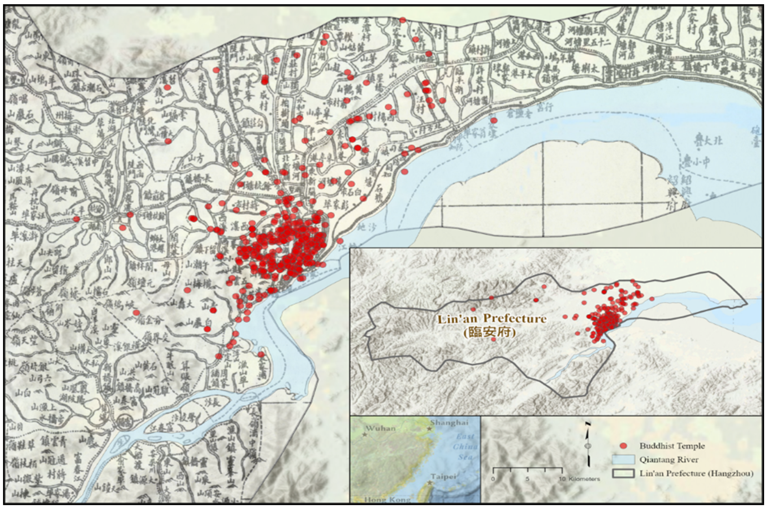
Figure 1 below is the visualization of all Buddhist temples recorded in the
Xianchun Lin’an zhi as follows:
The base map of choice in
Figure 1 (and the remaining figures with base maps) is the Qing-dynasty Hangzhou prefecture map (
Hangzhoufushu quantu 杭州府屬全圖) in the
Historical Atlas of Hangzhou (
Hangzhou gujiu dituji 杭州古舊地圖集), published by the Hangzhou Archives Bureau 杭州市檔案館 in 2006. It was georeferenced by the authors in ArcGIS Pro with a second order polynomial by adding 63 control points.
The following two trends can be observed from the map: (1) Buddhist temples in the study area are unevenly distributed, and (2) there is a noticeable cluster in the bottom right corner of the study area. However, the scale of the map is too large for us to define the degree of its spatial distribution—we do know that, from its appearance, the data seems to be clustered, but to what degree? More importantly, where are those temples clustered? Hence, we need to perform a series of quantitative analyses to identify the data on a smaller scale in a logical order as follows: (1) Average Nearest Neighbor (ANN) analysis that testifies to the tendency of data distribution, ruling out the possibility of a random distribution, (2) quadrat analysis for studying the spatial arrangements of the point locations, and (3) kernel density to find out where precisely the points are located.
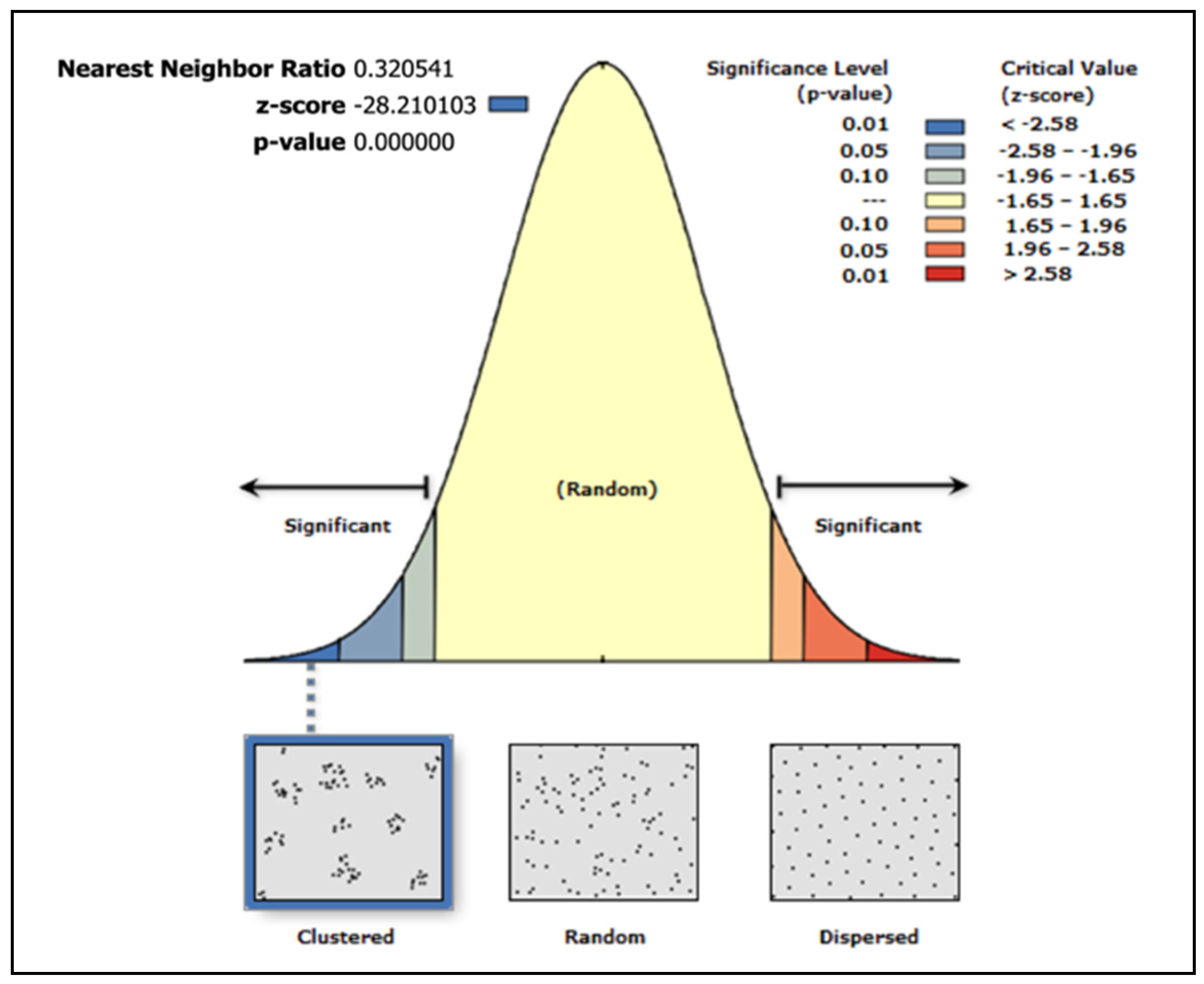
4.1. Average Nearest Neighbor (ANN)
The ANN analysis can determine whether the data is dispersed, clustered, or distributed randomly by calculating the average distance between all data and their nearest data points to determine the degree of distribution. Its formula is shown as
while
and
. In the formulas above,
is the observed average distance and
is the expected average distance for a hypothetical randomized distribution.
is the distance in between the data point
and its nearest points,
is the number of all points within this dataset, and
is the study area that encloses all the temple points. The result of the ANN analysis generates a graph to indicate the distribution as in
Figure 2 below as follows:
From the extremely low z-score and p-value, we can see that there is less than a 1% chance that the distribution is random. Hence, we can claim that Buddhist temples are very clustered in our study area. However, this result only tells us about the tendency of the clustered data points, but not how and where the points are clustered.
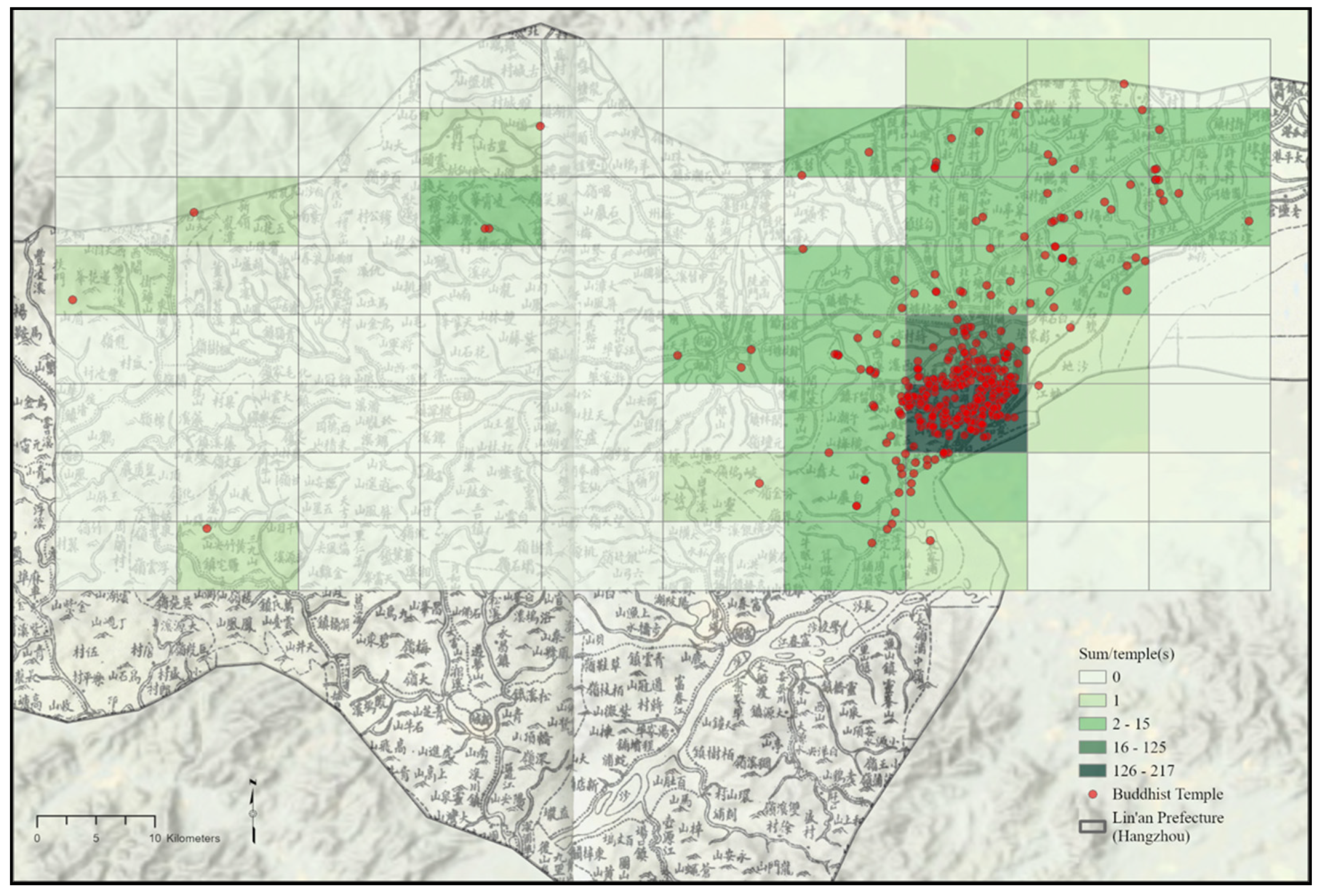
4.2. Quadrat Analysis
Given the results from ANN indicating clustered points, we can determine how the data points are arranged in the study area in a two-step process. First, we superimpose a fishnet constructed of rectangular cells (59 square kilometers per cell) onto the study area and calculate the number of points in every cell. This superimposed fishnet can also tell us how the points are arranged in the study area; see
Figure 3 below:
Building upon the results from ANN that the data points are clustered, we can see that the temples are clustered within the darkest cells from the image above. Second, we calculate the frequency of points in all cells. This frequency value, VMR (variance-mean ratio), represents the variability of data points in cells in terms of the observed frequency and the mean frequency. Then, we calculate the pattern of data distribution based on the numbers in each cell.
From
Table 1, we can see that 338 Buddhist temples (72.1% of the total number) inhabit the top-three populated cells within the study area. They are heavily clustered in only three cells out of one hundred cells—within 3.33% of the landmass in our study area lies 72.1% of Buddhist temples. Coincidentally, 72% of the cells are empty without Buddhist temples. The results indicate a significantly uneven distribution but without a clear indicator of the exact locations.
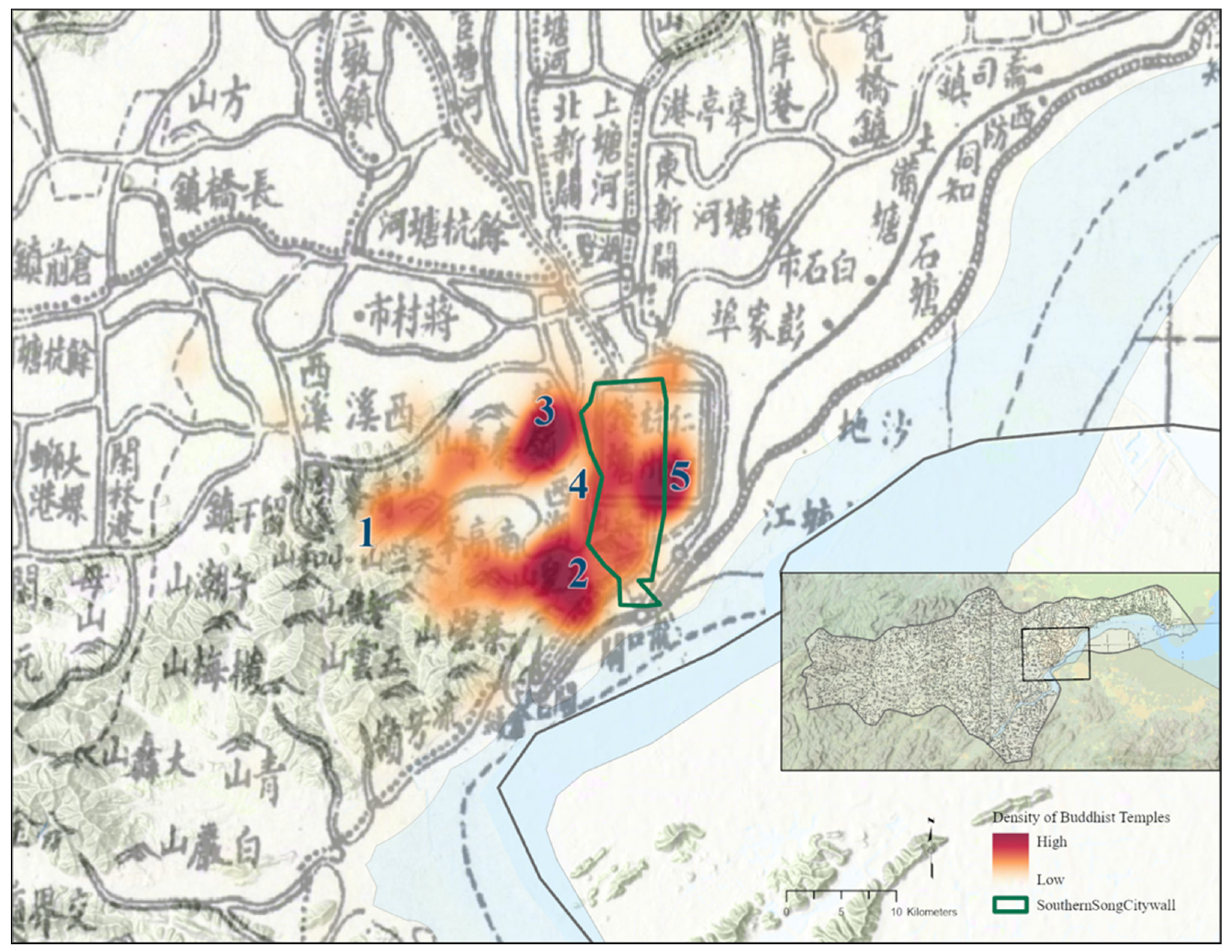
4.3. Kernel Density
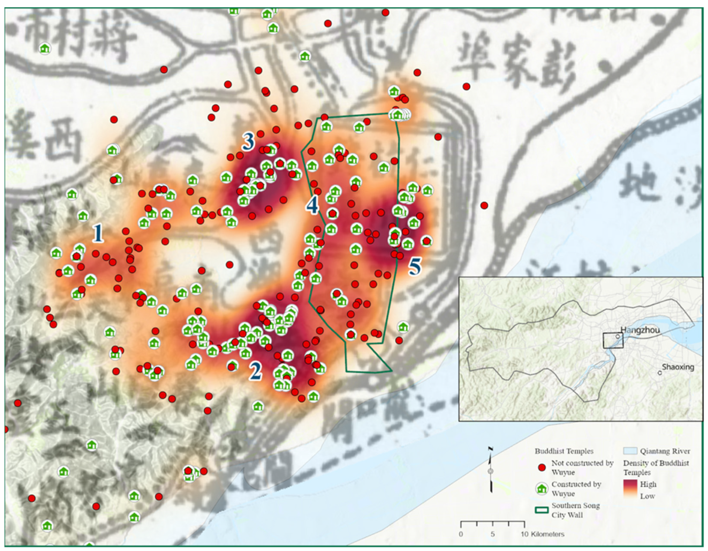
We have narrowed the scale to three cells with the highest frequency of temples, but the clustered locations remain unclear. The result of kernel density for Buddhist temples is represented by kernels with a cell size of 0.0001 square kilometers and the search radius is left blank. It is to this analytical approach of kernel density that we can add a feature (as shown in
Figure 4 below) for further clarification—city walls. The Lin’an city walls of the Southern Song were reconstructed based on the groundwork of the city walls built in the Wuyue kingdom period for military purposes. The Southern Song city walls were pulled inwards on the northwestern and southwest sides; the total area that was enclosed shrank and became smaller than the Wuyue city walls. The Lin’an city walls in the Southern Song did not have a large-scale expansion compared with the past. The Lin’an city walls only expanded once at the southeastern corner in the early times of the Southern Song, for the convenient commute of imperial officials to enter the palace.
There are the following five noticeable hot zones (marked with blue numbers) on this map with higher temple density: (1) the middle-left spot located at Mt. Tianzhu 天竺山, (2) the bottom left spot at Mt. Yuhuang 玉皇山, (3) the upper left spot at Yuhang Gate 餘杭門 (present-day Wulin Gate 武林門), (4) a meridional path-like zone connecting Mt. Yuhuang and Yuhang Gate, and (5) the center east area on the edge of the city wall. However, acknowledging the clustered zones is not enough to construct a narrative that fulfills the thesis of this article—to view religion at a regional scale and observe its interactions. To achieve this goal, we will now turn to the interpretation of those digitized mapping results via corroborating with historical materials in the upcoming section.
5. Interpretation via Close Reading
As mentioned previously, GIS approaches provide the opportunity to use distance reading in studying Chinese religious texts. The advantage of employing distant reading is being able to discover whatever patterns are already present in texts but cannot be observed by close reading, a traditional textual approach. Distant reading is assisted with GIS in processing a large quantity of texts and further mapping the texts out. This term was proposed by Franco Moretti as a counterpart of close reading, where he intended to argue against the “narrow” pursuits of area studies and national literatures and to renew the study of world literature (
Moretti 2013). Later, scholars employed distant reading to discuss the application of GIS and received beneficial results.
However, the results from GIS distant reading often lack the evidential interpretation gained from close readings. We need to corroborate the results with religion-related facts recorded in historical sources, which provide a new insight into socioreligious manifestation within a locality. For example, Jason Protass examines how religious lineage changed over time in China by studying the spatial pattern of the Northern Song Chan lineage recorded in
Lamp Records. He mapped out the five Chan sects and corroborated the pattern with textual records (
Protass 2016).
5.1. Explanation of Distribution
5.1.1. Fengshui 風水
From our results, three of the five zones of the distribution of Buddhist temples—Zones 1, 2, and 3—were built surrounding the West Lake. The seclusion and the tranquil atmosphere attracted monks and practitioners to conduct Buddhist practices, a description of the Yunqi Temple 雲棲寺 coincides with this statement, “[The temple] …being separated from the urban activities…the enclosing mountain and riverine system…is the perfect and only place for a person with the Way (
youdaozhe 有道者) to stay at.” (
Wu 1780). Apart from the scenic views, the
fengshui tradition is an important reason for its distribution. The temples that are situated with the mountains at the back and overlooking the river are ideal for accumulating “
qi 氣,” and thus are in good
fengshui conditions.
Take Zone 1 for example, the mountainous and riverine landscape surrounding Mt. Tianzhu 天竺山 makes it ideal for constructing Buddhist temples with good
fengshui, such as the Lingyin Temple 靈隱寺, the three Tianzhu temples 三天竺寺, and the Gaoli Temple 高麗寺. A passage from the
Gazetteer of the Lingyin Temple 靈隱寺志 recorded as follows:
“for ancient saints who practice the Buddha’s teachings, it was always the case for them to leave the urban areas and dwell in the mountains and woods. Such a place serves best for ‘venue of the Way (daochang 道場).’ A venue of the Way is a place for practitioners to concentrate; it is not to mix with the profane! Hence, ancient temples must be located at famous mountains, so that practitioners can absorb the ‘qi 氣’ from the mountain and the water.”
In Zone 2, the stele erected at the Hupao Temple 虎跑寺 also stated that “the surrounding mountain and river are filled with auspicious aura (
lingqi 靈氣), and the Hupao Spring is the best location to construct a temple.” (
Wu 1780). Hence, since Hangzhou is naturally endowed with mountain and river landscapes, it is not surprising that a cluster of Buddhist temples is located here.
The fame of the temples around the West Lake also attracted travelers for pilgrimage and sightseeing fueled the tourism industry—in Zhou Mi’s 周密 (1232–1298)
Old Affairs of the Martial Grove (
Wulin jiushi 武林舊事), a comprehensive record of Hangzhou in the Southern Song, had a chapter specifically titled “Spectacular Scenes of Lakes and Mountains (
hushan shenggai 湖山勝概)” to record religious sites as popular tourist sites. In Xiaolin Duan’s
The Rise of West Lake: A Cultural Landmark in the Song Dynasty, she calculated the percentage of religious sites amongst all the sightseeing routes recorded in the
Wulin Jiushi and discovered that the routes of three Tianzhu temples, Southern Mountain 南山, and Ge Hill 葛嶺 (Zone 1, Zone 2, and Zone 3 respectively) are the most popular (
Duan 2020). Moreover, the high temple density in Zone 5 made it popular amongst pilgrimage travelers in future dynasties. For instance, the Zhenhai Chan Temple 鎮海禪院 (also known as the Haichao Temple 海潮寺), was a major hub for pilgrimage in the Ming dynasty—it served as a facility filled with pilgrimage-related services for travelers, and it also received government support to promote Buddhism. (
Zhang 2022) Hangzhou was one of the waypoints for the Guanyin pilgrimage at Mt. Putuo, and it received travelers from multiple directions as follows: north from Huzhou 湖州, northeast from Jiaxing 嘉興 and Suzhou 蘇州 (also from the Grand Canal), and southeast from Ningbo 寧波. Although the distribution of Buddhist temples around the West Lake was not solely influenced by pilgrimage and tourism, the temples directly resulted in the rise of pilgrimage and excursion that showcases the interaction between religion and leisure activities.
5.1.2. State Power
Besides the
fengshui tradition, the hot zones are also a manifestation of state power in the form of religion, especially from the Wuyue kings’ ambitions to transform Hangzhou into a Buddha land. We mapped out the distribution of the Buddhist temples that were constructed by the Wuyue kings, as shown in
Figure 5 below. This piece of information was extracted from the temple description in the
Xianchun Lin’an zhi (fascicles 76–85). We then performed a spatial query via ArcGIS Pro to identify which temples were constructed by the Wuyue kings. We can clearly see from the map that the temples built by Wuyue are mostly situated around the hot zones (apart from Zone 1).
Ever since the Wuyue kingdom, the Hangzhou region has undergone an initiation of transformation into a Buddhist sacred space. The Wuyue kings endeavored to define their Buddhist regime through “expansion and promotion of the Buddhist clergy, printing and publication of Buddhist texts, production of Buddhist images and sculptures, and, above all, the building of monasteries, temples, and pagodas.” (
Welter 2022) Buddhist temples and stupas were erected to serve as markers to represent the rulers’ power, illicit harmony, and translocate Buddhism from its Indian roots into China. For example, the Jingci Temple 淨慈寺 in Zone 2 was constructed by the Wuyue king Qian Hongshu 錢弘俶 (929–988) for the famous monk Yongming Yanshou 永明延壽 (904–975), which then became prominent within the Five Mountain and Ten Monastery (
wushan shicha 五山十刹) system in the Southern Song.
Besides receiving influence from the Wuyue court, Zones 4 and 5 can also observe the state’s power during the Southern Song. The Southern Song court built many official Buddhist temples (
guansi 官寺) in Zones 4 and 5 for the sake of establishing state power and serving the imperial correspondents—royal families and government officials often partook in Buddhist festivals and rituals in those official Buddhist temples. For instance, the
Xianchun Lin’an zhi recorded that in the Mingqing Temple 明慶寺, one of the official Buddhist temples in Zone 5, “whenever the emperor is holding a ritual, all of his subordinate officials will be present.” (
Qian 1970).
Although Zone 1 has fewer temples that were constructed by the Wuyue kings, we can still observe the impetus of state power in its temple developments. For instance, though the Lingyin Temple was not initially constructed by the Wuyue kings, its prominence is highly associated with imperial courts in different reigns. In Wuyue’s regime, king Qian Liu 錢鏐 (852–932) expanded the Lingyin Temple by building 1300 rooms and halls. In the Northern Song, the temple became an empress’s merit temple (gongde miao 功德廟, a temple built to accumulate merits for the afterlife for whom it was built for). The emperor thus bestowed the temple with a large mass of farmland. The prestige of the Lingyin Temple was sustained until the Southern Song and it was also established as one of the temples of the Five Mountain and Ten Monastery system.
5.1.3. Politics
The policy of the empress/concubine family temple system, unique to the Southern Song dynasty, also played an essential role in the distribution of Buddhist temples in Zones 1, 2, and 3. The system was established and institutionalized in the Southern Song, being unprecedented and not seen in later dynasties in Chinese history. In this system, almost every established empress can have their own merit temple or burial temple (
fensi 墳寺) (
Hong 2012). Many of the imperial merit temples were built around the West Lake (in Zones 1, 2, and 3) because the Lin’an city (especially within the city walls) was too crowded to construct temples (
Mou 2008). Zone 1, for instance, includes the Jiqing Temple 集慶寺, which was built by the Southern Song emperor Lizong 宋理宗 (1205–1264) for Concubine Yan 閻氏, with records that “the halls and shrines are even greater than the Lingyin Temple and the Tianzhu Temple.” Other examples of Zone 1 include the Zifu Temple 資福寺 built for Concubine Feng 奉妃 as her merit temple, and the Jianfu Temple 薦福寺 for the Empress Dowager as her burial temple. There were also temples in Zone 2 newly constructed in the Southern Song that served the function as merit temples or burial temples for empresses, as recorded in the
Silent Records by Zhanyuan (
Zhanyuan jingyu 湛淵靜語), “After bounding south, all seven emperors are buried at Dongyue 東粵, and all five empresses are buried at Chishan 赤山 (present day Chishanfu 赤山埠) in Hangzhou.” (
Bai 1985). Hence, the empress/concubine family temple system and the ties with state power are reflected in the influence of politics on temples.
5.1.4. Commercial Activities
The three sections above explained how factors including
fengshui, state power, and politics directly influence the distribution of Buddhist temples. In this section, however, we would like to turn to discussing how the distribution of Buddhist temples became factors that influenced other spatial patterns. In our observation from the visualized maps, the distribution contributes to a cluster of certain commercial activities—or the term “sacred economy”—used by Michael Walsh to describe the situation in which humans endeavor to “conduct communal actions and transactions within a monastic setting.” (
Walsh 2010).
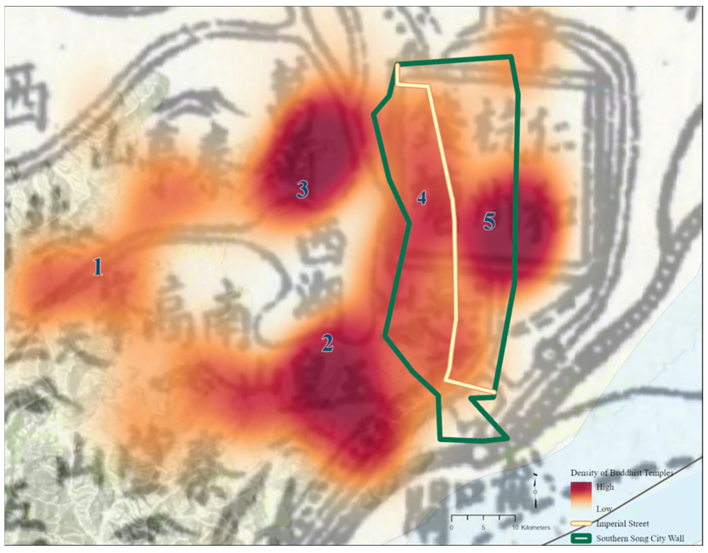
In Zones 4 and 5, the meridional pathway between the two zones coincidentally highlights a unique feature that is recorded in the
Xianchun Lin’an zhi as follows: the Imperial Street (
yujie 御街, sometimes also recorded as
Hangcheng dajie 杭城大街 or
Hangzhou dajie 杭州大街). We highlighted the pathway in
Figure 6 below. The location of Imperial Street is georeferenced with Shiba Yoshinobu’s historical map of Lin’an city in his
Chūgoku toshi shi 中國都市史. (
Yoshinobu 2002).
Both sides of the Imperial Street were called the Imperial Corridor (
yulang 御廊), it was a national trading hub filled with regional goods from all over the country. Recorded in Nai Dewong’s 奈德翁 (date of birth and death unknown)
Splendor Records of a Capital (
Ducheng jisheng 都城紀勝), “pearls and jewels, treasures and rarities, fresh flowers and fruits, seafood and wild food, marvelous implements and utensils, all the unique commodities in the world are assembled here in the morning.” (
Nai 1982;
Xie 2016). There were more than 150 stores on the Imperial Street that the historian Lin Zhengqiu 林正秋 divided into the following seven categories: daily groceries, restaurants, clothing, books and stationaries, medicine, pawnshops, and entertainment centers (
Lin 1990). Almost half of the population within the city lived along this path—324 people per acre as estimated by Gernet, which approximately delineates Zones 4 and 5. (
Gernet 1962).
According to the
Xianchun Lin’an zhi, the Imperial Street is explicitly built for the emperor’s seasonal ancestor worship (4 times per year) from the imperial palace to the Jingling Temple 景靈宮. The route of the emperor’s worship began from the imperial palace (on the southern end of the city) and ended at the northwestern corner of Lin’an city. In addition to the emperor’s ancestral worship, there were also many Buddhist festivals, birthday celebrations for the emperor or the empress, and rituals that royal members, government officials, and commoners participated in at Buddhist official temples. As mentioned in earlier sections, many official Buddhist temples were newly built by the Southern Song court along the Imperial Street (Zones 4 and 5) for the sake of serving the imperial family or government officials. For instance, the
Mengliang lu 夢梁錄 documented that the Qianqing Guanghua Temple 千傾廣化院 was the venue for “praying for merits in the Lin’an Prefecture” and “governmental officials celebrating and praying for the emperor’s birthday.” (
Wu 1980).
Owing to those religious activities, many worship-related items were in demand in the proximity of the official Buddhist temples—including incense, candles, paper money, flowers, pastries, fruits, and exquisitely handcrafted artisan souvenirs (
Duan 2020;
Chen 2013). The
Mengliang lu recorded that whenever the emperor worshipped at the official Buddhist temple, he bestowed handcrafted flowers (made from paper and fabric) to surrounding officials and his entourages, and those artisans were bought from shops in the Imperial Corridor (
Wu 1980). Those religious activities not only increased the demand for worship-related items but also generated great market opportunities for the surrounding businesses, including restaurants or entertainment hubs.
We are not to claim that all the prosperity of the Imperial Street was attributed to the worshiping activities of temples. There were still other conditions, such as Daoist and folk religious festivals, or locations of official institutions. For instance, the Three Institutions (
sanxue 三學; Imperial Clan School, Imperial University, and Military Academy) and the Examination Hall of the Ministry of Rites (
libu gongyuan 禮部貢院) were on the Imperial Street, which hence promoted book markets and house rental services for students (
Yao 2019). However, this project aims to the distribution of Buddhist temples, we only focus on the commercial exchanges associated with its religious activities. Hence, since our findings indicate that the temples coincidentally reside in commercial districts, what we are trying to explain above is that certain commercial exchanges within the commercial districts are results of the congregation of Buddhist temples; not the other way around that the temples were built because of the congregation of commercial activities.
5.2. Theoretical Considerations
One of the ironies in Chinese Buddhism, especially in monastic life, is the contradiction between the renunciation of the materialistic world and also being able to accumulate wealth through this act of renunciation—i.e., Buddhist practices. As stated by Michael Walsh in his
Sacred Economies: Buddhist Monasticism and Territoriality in Medieval China, the Buddhist community is one of the most powerful economic forces in society (
Walsh 2010). For Buddhist entities, including establishments, institutions, and communities, to secure their longevity as a religion down the road of history, wealth accumulation is necessary. After all, a Buddhist temple
“needed funding, donors, lay supporters, monks to inhabit it, an abbot to oversee it, offices, bookkeepers, workers, farmers, wood, and tiles. To acquire these necessities, it depended on a reciprocal exchange process between institution and social agent, which in turn produced a space of consumption; meaning infused into that process made it sacred.”
In his
Practical Reason: On the Theory of Action, Pierre Bourdieu (1930–2002) framed religion within an economy by stating that religion is simultaneously an enterprise with an economic dimension but at the same time cannot openly admit participation in the economy (
Bourdieu 1998). In other words, religious institutions are aware of being engaged in economic exchange but are able to persuade themselves that it is not an act of economic exchange. The rationale, provided by Bourdieu, was that as soon as religious agents realize that this action can benefit their religion, they are willing to overlook the definition of the notion of “economic exchange” to justify their actions and functions. It is “a network of relations where those forces are instituted, shaped, and conditioned” that greatly benefits the sustenance of a religion (
Walsh 2010). For religious institutions to flourish, they should be situated within the social-economic territory that generates power and legitimacy within a certain cultural context. Hence, the combination of cultural and economic capital produced longevity for a religious institution. Starting from the Song, monasteries served as market or economic centers due to their active participation in local exchanges, including the following:
“trading, allowing for the interaction of literati and monks, disseminating Buddhist texts and lectures, sometimes even paying taxes in support of underemployed farmers, hiring field laborers, supporting local fairs and markets, and fully participating in the kind of sociopolitical atmosphere that allowed such an increase in commercialism and exchange to happen.”
Apart from commercial exchanges that fueled religious growth, our results verified Walsh’s statement and indicated that the spatial pattern of Buddhist temples is also related to factors including influences from state power, governmental policies, population, and geographic landscapes. The relationship between the spatial formation of religious sites and external factors in a region can be explained by a theory proposed by Jiang Wu, Daoqin Tong and Karl Ryavec in 2013—Regional Religious System (RRS)—a new theoretical understanding of the regional pattern of the religious sites’ distribution. They took a combinational approach of utilizing GIS technology on regionalism and suggested that the spatial formation of religious sites in the locality can be understood as a regional religious system in which religious institutions “are conditioned by physical, geographical, administrative, cultural, or socioeconomic systems and are highly dependent on regionally and locally distributed variables such as population, economy, transportation, education, culture, ethnicity, and language, etc.” (
Wu et al. 2013). Hence, discerning the distribution of religious sites suggests an existing regional system or model surrounding religion.
Sophisticated sociocultural integration with Chinese religion can be observed as a structural formation, and the results of our study depict this phenomenon from a regional perspective. GIS analyses and interpretations are not the final steps in this study. The meaning and value of the results are more effectively generated via combining distant and close readings—distant reading of the Xianchun Lin’an zhi provides us with details of religious elements, and close reading of it and other historical sources offers evidence for further interpretation of the visualized maps (resulting from distant reading). GIS serves as a vehicle that enables us to acknowledge when, where, and how geographical attributes might have contributed to answering specific questions.
6. Concluding Remarks and Ways Forward
Through geoparsing Buddhist elements in the
Xianchun Lin’an zhi, we can closely examine how Buddhism was imagined and manifested in a regional context that may not be easily performed by close reading. This process of data distillation from historical materials is what we in the field of the humanities have yearned for. As claimed by Jason Protass, “GIS is a tool that magnifies whatever patterns are already present in our source texts” (
Protass 2016)—we make use of this approach and paint the Southern Song dynasty Buddhist landscape on a canvas that is ArcGIS Pro and its visualized maps.
For locating religious sites from historical sources, we are aware of the limitation and the veracity of the data source—government records are not as accurate as fieldwork results (i.e., to physically locate the temples on-site). Kenneth Dean once claimed that “one of the greatest sources of frustration in historical GIS research in China concerns the limited scope of data within the traditional official gazetteers” and Fenggang Yang remarked that “county-level government officials may routinely underreport numbers of religious site because of political considerations.” (
Dean 2022;
Yang et al. 2022). It is true that datasets compiled in recent years can be corroborated via intensive fieldwork that Dean and Yang did in their respective works. However, for historical datasets (such as the Song dynasty Buddhist temples in the article), what we can do is construct a preliminary database and distill key information from historical sources. In this way, we can still achieve the integrity of the data that Dean said on gazetteers to “indicate historical peaks in religious construction.” (
Dean 2022).
The potential of applying GIS to Buddhist research is vast and immense. GIS provides us with a new pair of lenses to look through—the role of spatial information in the Buddhist world. In this case, the essential materials required to apprehend the Hangzhou Buddhist culture are easily captured via GIS. Materials include implicit intertextuality between people, places, and events that can be linked together via a broader knowledge originating from conducting direct research on the database itself.
Although GIS can enhance our processes and understanding, we should know that GIS cannot be treated as a replacement for traditional Buddhist studies research. There is no denying that GIS approaches are competent in bringing out novelty and depth of research, but it is always the primary sources that engender research questions and hypotheses. Though digital approaches in the humanities (especially Buddhism) seek to alter the means of research fundamentally, “the traditional focus on language, texts, art, culture and ideas remain the same.” (
Veidlinger 2019). GIS does not self-generate issues to solve but acts as a magnifying glass that amplifies the minute nuances in the materials that we may not be able to discern via close reading.
This study does not claim that Hangzhou can represent all of China, either spatially or temporally. Instead, we regard this study as a stepping stone for future research on religion focusing on regionality. Hangzhou is merely one of the many regions in China with a rich Buddhist culture; there is ample data recorded in various methods across different places and dynasties. According to Timothy Brook’s calculations, there are over 1500 unique regions with rich local materials to explore all across China. Indeed, there is a gold mine of data for regional religious studies that deserves our scrutiny. However, not all of these data are ready for conducting analysis. One of the major obstacles to acquiring data for regional studies is the paucity of digitization. Quantitative analyses and visualization cannot be performed without converting qualitative textual data into quantitative numeric data—geoparsing the Xianchun Lin’an zhi is an attempt made in this regard. Hence, data acquisition and digitization would be the next steps forward. For future steps in terms of the methodologies during quantitative analysis, we believe that performing more sophisticated analyses (including spatial regression, network analysis, and even XML/TEI tagging applied with AI) can bring more depth to understanding the data.


