1. Introduction
This paper presents an analysis of the spatial organization and ritual movement of the early medieval (800–1325 CE) Śaiva pilgrimage landscape in the Hemakuta Hill area of Hampi, Bellary District, Karnataka, South India (
Figure 1). The Pampa
tirtha (pilgrimage), prior to the foundation of the Vijayanagara Empire (c. 1336), is generally considered a relatively homogenous, albeit sacred space. The wealth of inscriptions and architectural innovations that flourished in this area during the Vijayanagara imperial era dominates research and easily overshadows the earlier history of the site. This study aims to develop a more nuanced and historicized understanding of this sacred space through the lens of spatial organization and pilgrim movement in the hitherto understudied early medieval period. In order to achieve this, two spatial data platforms have been used: a geographic information system (GIS) and Google Earth Street View to supplement epigraphic, architectural and textual evidence. The natural and built landscape features of the area were digitized through Esri’s ArcMap (ArcMap is Esri’s traditional desktop application for mapping and spatial analysis that will be phased out and replaced with ArcGIS Pro by 2026) to historically situate the extant stone monuments, as recorded by the Vijayanagara Research Project (
Michell et al. 2001, vol. 3) and as identified through satellite imagery. Then, devotee movement has been modelled through the pilgrimage space on time-sensitive maps of architectural and natural features. Pathways of movement across the site that pilgrims followed in the time period under investigation have been subsequently explored in the immersive panoramic imagery captured for the Hampi landscape in Google Street View. The nature of Google’s Street View technology and imagery enables a ground-based assessment of visual and physical accessibility, as well as a sensorial engagement with non-ephemeral pilgrimage landscape features to be assessed. By combining these digital tools, a historicized analysis of the character and qualities of place, based on the organization of the site, are identifiable. The Pampa
tirtha is thereby conceptualized and analyzed as a network composed of distinct spaces (nodes) linked through devotee paths of movement, the result of which highlights how central cultic relationships were influencing the organization and development of the pilgrimage space over time. The most important and enduring of these relationships was between the deities Pampa and Bhairava.
The earliest religious stone architecture built in the Hemakuta Hill area was a shrine devoted to the local river goddess, Pampa, and another dedicated to her counterpart, Bhairava, also referred to as Mahakaladeva (c. 800 CE). The river goddess Pampa personifies the nearby Tungabhadra River and is the progenitor of the sacred space. Bhairava, the fierce manifestation of Śiva, is one of the three major deities of the site. From this foundation, an organizational influence of Pampa and Bhairava extended throughout the early medieval period and across a continuously developing pilgrimage area. The location of their shrines demarcated the physical and metaphysical north (Pampa) and south (Bhairava) extents of the sacred pilgrimage space. The northern area of the site was a space of auspiciousness, emanating from Pampa, versus the south end of the sacred pilgrimage area, centered on the Bhairava temple, associated with inauspiciousness. In the 12th century, the third major deity of the Pampa tirtha, Virupaksha, was introduced to the sacred space. In the following centuries, Virupaksha became the Sanskritic tutelary deity of the Vijayanagara Empire.
The Hemakuta Hill pilgrimage space provides a unique sacred setting for the exploration of ritual movement due, in part, to its excellent preservation. To this day, it is understood by visitors and local residents as a nucleus of sacred space within a broader sacred landscape. In addition, the tirtha was part of a larger Deccan-wide cult of memorial shrines for ancestor worship, which brought about royal memorial shrines to be established at the site. Through a digital and temporal reconstruction of the Hemakuta Hill sacred space in Hampi, spatial patterns of architectural development throughout the early medieval period (800 to 1325) support the assertion that the presence of Pampa and Bhairava, at their oppositional ends of the site, conferred and shared their qualities to their temple vicinity, influencing organizational decisions for the location of subsequent religious architecture in the period of interest. Furthermore, the distinct qualities of the north and south spaces were developed through the use of natural landscape features for the placement of religious architecture identifiable when explored through the lens of devotee movement and sensorial experience.
Unique minor topographic features (microtopographic features) that characterize the surface and northern foothill of the Hemakuta Hill substantially influenced how surrounding religious architecture placed themselves in relation to them. For example, microtopographic features, such as depressions, natural pools, high points, and flat spaces, were used to create lines of sight or intentionally blocked sightlines. Influencing orientation and the placement of shrines and temples, microtopographic features were also used with precision in architectural planning to create structural alignments (that may not have been visible) and correspondences with elements in the broader landscape or other local architectural features. Additionally, in some instances, microtopographic features were incorporated into temple and shrine structures, thus integrating the sacred hill into themselves. Microtopographic features also provided natural pathways for moving across the undulating granitic surface of the Hemakuta Hill, progressing from the south to the north end of the pilgrimage space, subsequently connecting the temples and shrines through a path of movement. The placement of temples, shrines, and gateways in relation to the pathways certainly affected spatial organization and devotee experience in this pilgrimage space.
Altogether, the Pampa tirtha espouses a sophisticated and intentional concomitant use of microtopographic features in the architectural organization of the site. The natural landscape lent itself as a tool for the creation of private and open spaces (physical accessibility), in addition to an interplay between what could be seen and what could not be seen (visual accessibility). My digital–temporal investigation of the Hemakuta Hill sacred space confirms that the interplay between religious architecture and natural features specific to the Hampi landscape was used to cultivate a spectrum of place-specific experiences for the pilgrim that was tied together by a path of movement and axis of organization for the site. It was along this axis into which the god Virupaksha was insinuated in the 12th century to naturalize his dominance at the pilgrimage space as it expanded into also being his cult center.
2. Materials and Methods
The religious architecture of the Hampi area from the 9th to the 13th centuries developed on and at the northern foothill of the sacred Hemakuta Hill. There are 28 extant monuments, including shrines, temples, monolithic gateways, and several subsidiary temple structures, such as an ambulatory and a feeding house for brahmins, as well as a large temple tank, the Manmatha Tank. The Vijayanagara Research Project recorded over 16 features added to the Hemakuta Hill after the period of this research, including perimeter walls and gateways enclosing and restricting access to the sacred space of the hill, stairs carved into the hill, and additional shrines and temples.
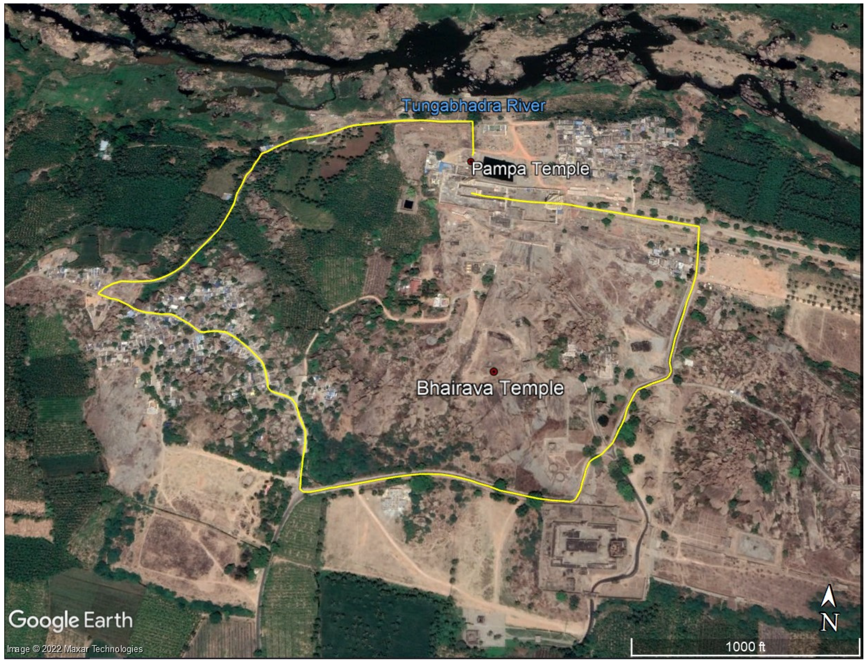
The Hemakuta Hill surface on which temples and shrines were erected measures approximately 300 m long from north to south and 150 m wide (
Michell 1992, p. 425). The hill itself is a gently undulating granite shelf, with soil accumulation in some slight depressions. Other depressions act as pools for natural springs or collect precipitation. Overall, the granitic face of the hill creates a setting characterized by microtopographic features. Weaving through these features, natural paths across the face and north foot of the hill organized devotees’ movement in this sacred space. These paths are suggested by several key factors: the undulations and boulder-free areas of the hill, and stone structures that channel passages running from the south end of the Hemakuta Hill to the northern foot of the hill. Over time, the path was enhanced by built features, such as gateways, and the general orientations and placement of shrines and temples that either intentionally faced or faced away from the paths. Through a spatial and temporal analysis, five spatial nodes, or distinct areas, have been identified based on their particular topographic and topological attributes within the Pampa
tirtha. The five nodes are in the following locations: the northern flat foot of the Hemakuta Hill (referred to as the north Pampa node); the northern base of the hill, between the slope and flat foot of the Hemakuta Hill (referred to as the north Virupaksha node); the north-facing slope of the hill (referred to as the north face node); the apex of the hill located to the southwest (referred to as the south Virupaksha node); and the depression at the summit of the hill, located at the southernmost end of the site (referred to as the south Bhairava node). The digital reconstruction of Hampi landscape in 800–1325, including the nodes and dominant paths of pilgrim movement, is presented in
Figure 2.
For the early medieval period, religious inscriptions found in Hampi play an invaluable role in shedding light on the people investing and developing the architectural and religious life of the site, as well as on dominant practices and ideologies. They also aid in constructing a chronology of site development, particularly when coupled with analyses of the religious monuments. There are nine inscriptions that reference and/or are located within the Hemakuta Hill area for the period under investigation. They record religious donations made at the Pampa tirtha in addition, but not limited to, the name of the donor, the reason for the donation, and the deity to whom the donation was made. The language and script employed was primarily Kannada. Additionally, eight were recorded on stone slabs, but the earliest four were not located in the Hampi area.
Although the earliest epigraphic evidence for the Pampa
tirtha is dated to 689 CE, the first stone monuments do not appear until the 9th century. From the existing body of architecture available for analysis between 800 and c.1336 (1336 is the approximate date for the founding of the Vijayanagara Empire), the long pre-imperial life of the Hemakuta Hill area can be divided into four distinct periods: 800–900, 1050–1100, 1100–1250, and 1250–1325. This periodization is adopted from Wagoner’s work (
Michell et al. 2001;
Wagoner 1996) and captures the changes that occurred according to observed spatial–architectural developments, cultic changes, and patterns of patronage.
During the period under investigation, the pilgrimage landscape saw the foundation of 22 temples and shrines plus 12 “renovations” to the existing temples and shrines. The term “renovations” is employed broadly in this paper, much in the same way that
Branfoot (
2013) observed in Tamil temples. It denotes identifiable upkeep and/or changes to a religious structure. For example, “renovation” in this context can refer to shrines that were expanded into temples. The rudimentary form of a shrine (
vimana) consists of a square or rectangular sanctum sanctorum (
garbhagriha) that houses the deity, with an attached antechamber (
antarala) or a small porch (the distinction between a shrine and a temple is a matter of modern terminology, useful for classifying structures, and is adopted herein from the work by
Michell et al. (
2001, pp. xiv–xvii)). This form can be expanded into a temple whose rudimentary form is composed of a shrine (
vimana) attached to a square or rectangular
mandapa (
Michell et al. 2001, pp. xiv–xv). “Renovation” can also refer to temples that were expanded with the addition of auxiliary structures such as a monolithic gateway (
kalla upparige), a freestanding ceremonial gateway, a feeding house (
sattra-sale), or an ambulatory. Lastly, “renovation” can refer to a temple that was expanded with the addition of new elements to the structure itself, such as an addition of another shrine or another architectural element (e.g., a bay or a columned hall [
mandapa]). The dataset for this research on the Hampi area shows that both the creation of new temples and shrines, as well as the renovation of existing structures, affected the overall organization of space and established new paths of devotee movement.
Many of the structures from the early medieval period in the Hemakuta Hill area are relatively intact due to the excellent preservation of the site after its almost-complete abandonment in 1565 CE. Looting that occurred at the site targeted the monuments outside of the hill area, indicating politico-religious tensions between Śaivas and Vaishnavas (
Rao 2016), and did not disturb the material of this study. Therefore, the stone architectural history of the Pampa
tirtha is observable for research. The body of material evidence has three significant traits. These include relatively intact stone religious monuments built in one of two architectural languages (Phamsana or Dravida), the use of the natural setting and features by patrons and artisans within a site that has not been grossly altered over time, as well as a limited epigraphic dataset. This rare and full picture of a sacred landscape from the early medieval period is at odds with the types of settings archaeologists commonly examine.
To begin the analysis, a digital landscape was assembled in ArcMap, rendering a 2D map of structures of interest and topographic features with associated attribute data that could be stored and queried (for an introduction to GIS and its applications to historical research, see
Gregory 2003;
Gregory and Ell 2007). Rendered architectural features (as polygon features with associated attributes that are stored in tabular form) were based on published data including site plans/maps and measured drawings, architectural descriptions, and photographic records from the Vijayanagara Research Project, particularly from
Vijayanagara: Architectural Inventory of the Sacred Centre (
Michell et al. 2001). The placement of these features in space, as well as the identification and digitization of microtopographic natural features, was initially performed through satellite data (Google Maps and Google Earth Pro [CNES/Astrium 2017], and GeoEye-1 imagery).
The material world of the Hemakuta Hill area has been investigated as it shifted over time, through a diachronic analysis of digitized material features of the landscape, which includes both architectural features and natural features, from microtopographic features to larger landscape features such as entire hills and rivers. A diachronic analysis enabled the identification and visualization of spatial and temporal patterns and processes in ArcMap. For example, monuments and natural features, once digitized, were assessed in terms of size, relative location in space (orientation, height/z-axis, and distance to surrounding landscape and monuments), topological relationships, as well as physical and visual access (line-of-sight and alignment between site features and to the broader landscape). If visual accessibility could not be determined in ArcMap, Google Street View was utilized. However, the qualitative nature of immersive data does not translate easily for tabulation in a database. For this reason, structural–spatial relationships that could engage sensorial experiences and affect movement were also examined alongside non-hierarchical descriptive categories stored in the ArcMap database. Indeed, the immersive panoramic capabilities of Google Street View were used to pinpoint natural topographic and microtopographic features on the surface of the Hemakuta Hill and those visible from the hill within the broader landscape. Such features and correspondences were generally too subtle to be identified through digital elevation models (DEMs) and satellite imagery in ArcMap.
It is not possible to “know” all the different perceptions and experiences of space (
Fogelin 2006, p. 74). Many of the differences in the perception of space are dictated through social codes that permit and restrict actions based on age, gender, and social class, but also through the sheer fact that each body and mind has its own corporeality, history, and attitudes affecting movements, meanings, and experience (
Ashmore and Knapp 1999, p. 16). The differences between individuals and groups may be amplified, or there may be attempts to dissolve interpersonal boundaries through the particular experiences choreographed into spatial ordering. These latter are the sorts of experiences that spatial analysis is specifically purposed to identify. The intended corporeal experiences and social interactions of devotees as orchestrated by dominant groups can thus be identified through spatial analysis. The spatial and temporal patterns that were present in the Hemakuta Hill area indicate that space was a resource used in increasingly complex and diverse ways into the Vijayanagara period, with the potential of regulating social interactions and religious corporeal experiences. Space, as a resource, was bound to rules for social activity, providing analysts with a schema that structured past behavior (
Ferguson 1996, p. 10;
Fisher 2009, p. 56;
Shapiro 2005).
As a tool for this research, Google Street View has facilitated remote access to ground level visibility of the site, a “humanistic perspective” (
Llobera 1996, p. 612), permitting the identification of “invisible” landscape features not discernible through the remote sensing or published data available for the Vijayanagara area, such as the microtopographic feature in which the Bhairava Temple was situated and various sightlines between monuments. My research has shown that microtopographic features guided, oriented, and were indeed perceptible to a devotee moving through space. This element of perspective constitutes an access point for exploring ritual movement in a space known to be sacred to the groups creating and living in it in the early medieval period. Perspective is absent from a fixed, bird’s eye-view plan or GIS-generated map. Google Street View provides the opportunity to emplace a mobile body as the center of perspective which traditional GIS spatial analysis, based mainly on map layers, does not afford (
Llobera 1996, p. 613). Microtopographic features structuring the site can be observed through the virtual interactions with the landscape, using Google Street View. In this way, GIS was used to record spatial–temporal footprints of features (built and natural), whereas Google Street View allowed for spaces to be “active agents” as opposed to simply “passive media” (
Llobera 1996, p. 614). In other words, these two approaches could be combined to investigate how the landscape of the Hemakuta Hill area played a major role in shaping the devotee’s ocular experience, movement, and the spatial organization of the site.
Additionally assessed were the inter-relationships between monuments and natural features as visual and physical alignments between objects (allocentric) and from subjects to objects (egocentric) without prioritizing an analytical focus on viewsheds, as is common in GIS-based archaeological research (
Fisher 2009;
Llobera et al. 2011;
Papadopoulos and Earl 2014). Viewsheds are the geographic areas visible from one particular position in space. Most spatial analysis software, such as geographic information systems, provides the tools to perform spatial analyses from an allocentric perspective that codes “relative to external features of the environment” (
Vasilyeva and Lourenco 2012, p. 353). Such a perspective is useful but is much more revealing when coupled with information from the egocentric perspective that Street View provides: the perspective tied to an observer. The ArcMap and Google Street View images have enabled analytical prioritization of the visual relationship between two points in space, the visual accessibility between subjects and/or objects. This distinction between viewsheds and lines-of-sight highlights the intentional landscape development and experience from a devotee, or pilgrim’s perspective. However, ephemeral dwellings, shops, stalls, and other structures of a temporary nature, as in most archaeological urban sites, have not been identified for this research.
The terrain of 1100 to 600 years ago was not identical to the present day, and minor changes are identifiable. However, such changes, overall, would not alter the findings of this study. For example, there is now sediment built up in the microtopographic depression in which the Bhairava Temple sits. The ground level in the past was lower than it is at present in this area, but the natural feature and the architecture are still observable and intact. Visibility obstructions through ground level change are less of an issue on the remainder of the granitic surface of the Hemakuta Hill, due to low rates of soil development typical of pre-Cambrian granitoid inselbergs and outcrops (
Porembski et al. 2016, pp. 28–29). Vegetation on and at the foot of the hill would have been minimal, similar to current conditions, due to the limitations on soil formation. Moreover, ways of seeing through Google Street View are also historically situated, and the photographic technology that it presents is from a viewpoint of a healthy modern adult, most likely male, who moved through the Hemakuta Hill space in 2015. The photographs frame and produce images from a particular modern body; however, it should be recognized that it is not the same as a medieval body. Alone, Google Street View images do not capture other sensory, haptic, or tactile experiences. As such, these images have been used to explore the visual field, but this process is significantly informed by personal physical field experience in the Hemakuta Hill area and qualified with topographic and environmental information derived from geospatial data where possible.
The present digital analysis of the Pampa
tirtha exposed numerous distinct areas within the sacred space with their own unique visibility, alignment, and topographic characteristics. All areas are connected by a natural path of movement running south to north through the site, across the undulating granitic surface and to the foot of the Hemakuta Hill. These areas can also be conceptualized as nodes, connected by pathways of ritual movement that form the larger pilgrimage sacred space network. Thus, space syntax concepts related to the configuration of space, a theory interested in how people divide and connect spaces (originating from
Hillier and Hanson 1984), as a heuristic and descriptive device, can be utilized for our purposes. Space syntax theory is a powerful tool for investigating and describing the ordering of space, human perception, and movement with a dataset that is both limited in terms of space and the number of structures available for analysis. Such is particularly the case for describing changes in the use of space for inter-structural spatial organization. The foundation of space syntax theory holds that society has an intrinsic spatial aspect and that spatial configuration is informed by social rules and ideas—as opposed to space being purely form and society being content (
Hillier and Hanson 1984, p. 9). In this way, the discussion of how space and society interact is one which is dynamic and active. The manipulation of space (acted upon) can consequently influence those worshipping (or inhabiting) it. As such, the chosen dataset of the Hemakuta Hill area from 800 to 1325 enabled the historical identification and description of the built environment through the application of access and configuration concepts found in space syntax. The term “configuration” denotes the transformation and ordering space into discrete and connected units through inhabitation (
Bafna 2003, p. 17).
Archaeological research examining the structuration and use of space, on any scale, typically has to strategize and account for missing material, including features such as routes and/or structure that provide data on accessibility, ordering, and movement (
Llobera et al. 2011). This is less of an issue in this area and period of study, due to the high level of preservation and integrity of artifacts that order space. The experience of movement and the pilgrimage space network structure can thus be identified and discussed with relative confidence in terms of how space was configured and developed.
Thanks to the nature of the topography, the Pampa pilgrimage space is contained in a small, clearly defined landscape, in which the role of movement in ordering space for experiential purposes is an inferable phenomenon. As will be shown, in this landscape, a network of linking ritual spaces became the foundation for the spatial development of structures and the unifying properties of movement. In modern ethnographic accounts of the Virupaksha Temple Complex established at Hampi in the 12th century (one of two Virupaksha temples established in the 12th century at the Pampa
tirtha that was expanded into a temple complex under the Vijayanagara Empire’s Sangama dynasty),
Kotecha (
1982) explicitly remarks on the fundamental nature of ritual movement in the life of the temple, as well as in the architectural development of the complex, and its relationship with the surrounding landscape. In effect, this movement functioned as an act of worship of the site, in a similar fashion to the documented imperial and modern ritual of circumambulating the Hemakuta Hill area, which functioned to define and integrate the sacred space within.
A linear trajectory across the hill, from the south to the north, most likely was not the only prescribed form of movement-worship (much like circumambulation as a “symbolic act of veneration” (
Bharne and Krusche 2012, p. 202)) occurring at the site from 800 to 1100, although it appears to have been the most dominant path of movement in the sacred pilgrimage space throughout most of the early medieval period. As such, the conceptual and organizational logic of the Pampa
tirtha rested on a southern and northern anchor: the Bhairava temple, located at the far south end of the Hemakuta Hill space; and Pampa temple, at the far northern end of the sacred space. A third major deity of the site was introduced in the 12th century: Virupaksha. The placement of two new temples dedicated to the Śaiva god was intentionally situated to disrupt the Pampa–Bhairava relationship, although the flow of movement through the site, until the Vijayanagara imperial period, continued to run south-to-north.
3. Architectural Setting of the Hemakuta Hill Sacred Space
The sacred space of the Hemakuta Hill area provides a unique ritualized and sacred setting for the exploration of ritual movement in a pilgrimage destination. According to South Asian tradition and pilgrimage research (
Fuller 2004, p. 209), echoed in the broader field of the anthropological study of pilgrimage (
Coleman 2002), the devotee enters into a sacred time and scape in the pilgrimage center, both physically and conceptually distant from their mundane life. The Hemakuta Hill area was and continues to be understood by visitors and local residents as a nucleus of sacred space within a broader sacred landscape. Although the city of Hampi was largely abandoned in 1565, several temples remained active, including the Virupaksha temples established in the 12th century. Modern ethnographic accounts of the current ritual life of the Virupaksha Temple Complex elucidate the bi-annual ritual that involves the ritual activation of the sacred space of the Hemakuta Hill area (
Kotecha 1982, p. 73). The ritual itself is known as
Giri Pradakshinapatha and consists of a processional circumambulation of the entire hill area (including the northern foot of the hill with the Pampa Temple, memorial structures, and Manmatha Tank area), out to the river and back to Virupaksha Temple with Virupaksha idols, priests and devotees (
Figure 3). The path taken demonstrates the local conceptualization of the Hemakuta Hill area as a unit of ritual space. This act of circumambulation ritually re-activates the sacrality of the Pampa pilgrimage space (
tirtha) through movement as a ritualized and “symbolic act of veneration” (
Bharne and Krusche 2012, p. 202;
Kotecha 1982, pp. 73–76).
The primary axis of spatial organization, and by extension, of movement, of the Pampa tirtha throughout the early medieval period was defined and anchored by two separate areas, referred to here as nodes, of religious architecture. The two nodes were established in the earliest period of this research, 800 to 900: one node defined the north end of the site and the other node the south end, on the summit of Hemakuta Hill. The north node consists of a cluster of shrines and temples built on a flat expanse at the foot of the Hemakuta Hill. There is a clear division of space between the granite outcrop of the hill proper and the foot of the hill that continues to the river, from the cessation of the slope and exposed granite to an area of increased sediment deposition with low-lying vegetation. From the 12th century onwards, one of the two newly established Virupaksha Temple areas (which would eventually be enclosed into a temple complex by a wall during the Vijayanagara period), came to mark this transition from hill to the terrain leading to the river. During the early period of 800 to 900, however, the terrain change would have been visually remarkable, between the smooth grey and boulder-strewn stonescape of the hill and the comparatively lush, fertile green grassy terrain where the Pampa Temple and its associated structures were positioned.
Religious monuments were not spread equally across the surface of the Hemakuta Hill. The areas that were developed during the early medieval period emphasized the south–north alignment and path of movement that connected either end of the pilgrimage space. Shrines and temples were primarily situated to be in close proximity to the south–north pilgrim path, as well as to take advantage of microtopographic features that enabled particular lines of site, predominantly a line of sight to the Pampa Temple area. The exception to this was the Bhairava Temple and companion shrine, situated at the southernmost end of the pilgrimage space, within a microtopographic depression at the summit of the Hemakuta Hill that hid the monuments from areas outside of the apex of the hill. The south side of the hill was not developed with monuments during the early medieval period and is characterized by irregularly spaced large boulders and uneven granitic outcrops with a gentle slope. The slope on the west side of Hemakuta Hill is abrupt and steep, making a western route up the hill an unlikely path. However, the east side of the hill is composed of large granitic boulder formations, such as a large mound near the south end of this east side of the hill. There is a natural path around the south end of this boulder mound that leads to the crest of the hill. Additionally, from this crest, the devotee enters the sacred space of the hill.
3.1. The 800 to 900 Period
As mentioned, stone architecture within the sacred space of the Pampa
tirtha was established in the 800 to 900 period through the foundation of two distinct nodes of monuments. At the north end and foot of the Hemakuta Hill, the earliest known stone temple, dated through stylistic analysis by Wagoner (
Michell et al. 2001), is the Pampa Temple. Originally, it was built as a shrine and was expanded into a temple form during the subsequent 1050 to 1100 period. Soon after the Pampa Shrine was built, six memorial shrines were constructed immediately to its south side. The south–north pilgrim path of movement runs along the eastern side of the northern node of monuments. These six shrines have been identified as memorials, based on their use of the austere Phamsana architectural language (
Wagoner 1996), akin to the memorial temples discussed by
Bakker (
2007) that have been erected to transfer merit to the deceased. The memorial nature of the monuments at Hampi is supported by later and limited inscriptional evidence associated with Phamsana temples, discussed below. The cult of ancestors was also a tradition documented by
Wagoner (
1986) at the South Indian site of Telangana (a site with a similar temple architectural heritage as Hampi). Five of the six memorial shrines, plus the Pampa Shrine, face an auspicious easterly direction, ranging from 100° to 114° from north, so that their longitudinal axis allows for the morning sun to shine in on the housed deity. By facing east, these shrines also established a tradition, extending into the other periods, of facing the path of movement which links the nodes of the site. Thus, by facing eastwards, the shrines also were open to the devotees that walked along the south–north pilgrimage path.
Sitting on the east side of the northern node of shrines and temples is the large Manmatha Tank, visible in
Figure 2. Although there is no established date for its construction, the spatial organization of built features at the foot of the Hemakuta Hill suggests that it was present in at least a rudimentary capacity during the early period of 800 to 900. The tank itself was most likely formalized during the Vijayanagara period, under Sangama patronage, into the stepped, polygon structure as it appears today, with shrine facades, relief carvings, and a small gateway pavilion (
Michell et al. 2001, vol. 1), as well as architectural elaborations and a paved terrace (
Michell et al. 2001, vol. 1). It measures roughly 50 m north–south by 37 m east–west. However, the tank was likely a natural pool without architectural elaboration during the 800 to 900 period.
The southernmost node on the hill was situated in a depression of the granite shelf on the summit. The shrines located within the microtopographic feature, the Bhairava Temple and a companion shrine (identified as H.40 by the Vijayanagara Research Project (
Michell et al. 2001)), are concealed by the gentle hill crests surrounding it so that the structures built within and any devotees therein were not visible beyond the crest. Both temples, built in the Phamsana architectural mode, are unusually oriented so that their longitudinal axis is open to the west (the Bhairava Shrine 267°, and H.40 ~270°), an inauspicious direction.
The prescribed point at the south end of the Hemakuta Hill at which devotees entered the pilgrimage’s Pampa
tirtha’s sacred space and the pilgrimage network of nodes, is not definitive for this period. They may have entered onto the hill from the southern slope, taking a path between patches of the sheetrock. If a natural pathway from the south was used, it has been obstructed through a later Sangama-constructed enclosure wall (an irregular two-faced wall, greater than one meter wide and of varying heights) that still encircles the pilgrimage space (
Michell et al. 2001, p. 153). Alternatively, devotees entered the sacred space from the south-east side of the hill, passing a large conglomeration of granite boulders to reach the summit. The later Sangama gateway attached to the enclosure on the south-east end of the hill suggests that this was the normalized entry point into the sacred space as it was situated in proximity to the 13th-century
kalla upparige (a freestanding monumental gateway discussed below), which channeled devotees entering the Pampa
tirtha.
Unfortunately, there are no inscriptional data on the pilgrimage for the 800 to 900 period. However, inscriptions prior to this period, and from the intermediary period in which there were no new monuments built (from 900 to 1050), are available and help establish the religious nature of the pilgrimage as well as the primary deities of the site. An inscription dated to 689–690 is in Togurshode, Kornool District of Andhra Pradesh, and mentions the Pampa
tirtha (
Wagoner 1996). It records a religious donation made by a Badami Chalukya king after a successful military campaign (
Burgess 1877, pp. 85–88). Two inscriptions from 1014 and 1018 also record religious donations made at the
tirtha after military campaigns by Nolamba chiefs, Iriva-Nolambadhiraja and Udayadityadeva, respectively (
SII 1939, pp. 10–12). The inscription dated 1014 records a religious donation offered “to the god Mahakaladeva of Pampa”; Mahakaladeva is the “great lord of death” (also identified as Bhairava). Similarly, the 1018 inscription records a religious donation by the Nolamba chief Udayaditadeva “to the
tirtha at the village of Pampa”. An additional inscription that mentions the pilgrimage is dated to 998. It records the religious donation by King Irivabedanga Satyasraya of the Later Chalukya Empire (also called Ahavamalla), to one of his ministers (
Patil and Patil 1995, pp. xv, 13;
Sastri 2002, p. 198). Based on these, we understand that as early as at least the seventh century CE, the site was a modest yet established local pilgrimage destination, the two primary deities were Pampa and a death-associated god, even though there are no extant structures from before the ninth century.
The non-local, royal donors of inscriptions, dated to 689–690, 1014, and 1018, visited the Pampa
tirtha while in proximity to the site after military campaigns for death-related rituals for their fallen soldiers. Their investment in the deities and religious life at Hampi appears to have been limited and based on the circumstantial convenience of its location. This assertion is supported through the location of the epigraphs in that they were not made and established at the site, but rather meant to be displayed elsewhere. The inscription from 689–690 is in Togurshode, Kurnool District, Andhra Pradesh, recording a gift to a Vedic scholar. The original location for the inscription from 1014 is unknown; however, it was relocated to Hospet, Bellary District. The inscription from 1018 records a gift to recipients in Bagali, in Bellary District, where it was erected (for further discussion of the inscriptions see (
Haak 2018;
Wagoner 1996)), also mentioning a donation made of food offerings to a deity, Kalidevasvami of Bagali.
The four inscriptions available before the 1050 to 1100 period refer to the goddess Pampa in such a manner that it is clear the pilgrimage site was identified first and foremost with her, either as the river pilgrimage site or as a goddess; it was “Pampa-tirtha” or “tirtha at the village of Pampa”. As such, she was the source of sacrality for the area. Her close identification with the sacred landscape, from at least 689 onwards, is especially evident in the 1014 inscription that records a second deity: Mahakaladeva. Pampa’s pre-eminence is supported through the identification of Mahakaladeva being subsidiary to the goddess. He is, after all, “Mahakaladeva of Pampa”.
The association with death at the Pampa
tirtha is supported by Vinayaditya I (inscription dated to 1014) and Udayadityadadeva’s (inscription dated to 1018) visits to the site for death-related purposes for their fallen soldiers after campaigning. This death association is further corroborated by several other contextual details. Pilgrimages to rivers in South Asia are integral to death rituals, as exemplified by Varanasi/Banaras, where pilgrims travel to submerge the ashes of loved ones into the sacred Ganges River (also a river goddess, the River of Heaven), to use the riverside cremation grounds, or even to die in the city to automatically gain liberation (
Eck 1982). The Ganges is the archetypical river of the subcontinent and other rivers are often deemed surrogates or manifestations of this great watercourse. Rivers and river crossings are also identified in textual sources, as critical pilgrimage nodes for mainly death-ritual purposes (
Wagoner 1996, p. 149), such as in the authoritative medieval Sanskrit text on pilgrimage and
tirtha, the
Tristhalisetu of Narayana Bhatta (
Schopen 1994, p. 287;
Wagoner 1996, p. 169).
In the proceeding period, epigraphic evidence identifies Mahakaladeva as the god Bhairava, which helps us understand his role at the
tirtha, particularly his relationship with the goddess Pampa and their organization power over the sacred space of the Hemakuta Hill area. Bhairavas often have a guardian role to a goddess or to another god, as seen in the central and western parts of the Deccan Plateau (
Cohen 1997). They can also act as guardians of water sources (
Masilamani-Meyer 2004, p. 218). Moreover, they have a fierce aspect (bhairava translates as the “frightful ones” (
Eck 1982, p. 60;
Wagoner 1996, p. 149)), and in that role, the
Śiva Purana 3.8.47 states the following: “You are called Bhairava because you are of terrifying features and you are capable of supporting the universe. Since even Kala [time] is afraid of you, you are called Kalabhairava” (
Cohen 1997, p. 28). In this form, the deity is connected to the origin-myth of Kashi, the archetype of the
tirtha (
Eck 1982, p. 213), in which he commits Brahmanicide in addition to acquiring suzerainty over Kashi (Varanasi). With suzerainty over Kashi, there is no god of Death, Yama. Instead, Bhairava metes out justice through a process called
bhairavi yatana that allows the deceased to suffer the consequences of their karma (bad karma) in an instant, thus allowing them or any other creature to be liberated (
moksha) afterwards (
Eck 1982).
In the period before 1050 to 1100, the goddess Pampa, associated with riverine soteriological properties of the site, and the god Bhairava, associated with death and indeed referred to as Mahakaladeva, firmly anchored and defined the Hemakuta Hill pilgrimage space. The path of movement, therefore, connects death and life, the south and the north, through devotee ritual movement and spatial organization.
3.2. The 1050 to 1100 Period
The architectural development of the period of 1050 to 1100 CE consists of the addition of two shrines to the north face of Hemakuta Hill and two new shrines and one temple to the nucleus of Phamsana shrines adjacent to the Pampa Shrine in the north Pampa node. This period also marks the beginning of shrine and temple renovations. Four shrines were renovated into temples through the addition of a
mandapa (pavilion). As mentioned, the distinction between a shrine and a temple is a matter of modern terminology, useful for classifying structures, and is adopted from the work by
Michell et al. (
2001, pp. xiv–xvii).
The two shrines built on the north face of the Hemakuta Hill, on a moderately flat shelf, were architecturally distinct from the shrines built during the previous period. The shrines have been named H.9 and H.12 through the survey work carried out by the Vijayanagara Research Project (
Michell et al. 2001). Together, they inaugurate the start of a new node, referred to herein as the north face node. The general location of the new node, situated approximately 100 m from the north Pampa node, has a view out over the foot of the hill and further north to the Tungabhadra River and Anjaneya Hill (one of five sacred hills of the area situated on the north side of the river (
Das 2006)). H.9 was built oriented to the east (99° from north) in a proto-Vesara mode of Karnata Dravida architectural mode (the only example at the site). Additionally, H.12 presents a unique form of Dravida whilst also being the first shrine built to face north at the site (6° from north) (see (
Michell et al. 2001;
Haak 2018, p. 135) for a detailed description of the architectural form). The isolated location of the node and the use of visually more ornate architectural modes from the many austere Phamsana memorial shrines in the north Pampa node mark this space on the hill as an intentionally visibly distinct space crafted by the shrine patrons and artisans.
A minimum of three new shrines were built in the north Pampa node in close proximity to the Pampa Shrine: the Nagandeshvara Temple, the Gulaganji Madhava Temple, and the M.12 Temple. Built initially as shrines, they were also renovated into temples with the addition of a mandapa during this same period—the exception being the M.12 shrine, that was renovated in the 13th century. There are at least four shrines in the north Pampa node that have not been dated because they are missing the architectural features necessary for dating (these are M.9, M.10, M.11A, and M.7A). It is likely that they were also built in this period. Regardless of the period in which they were built, the north Pampa node was in a constant state of development during the early medieval period with new monuments and monument renovations. However, the tradition of building in the austere Phamsana style (characterized by its stepped pyramidal superstructure) appears to no longer be favored in this period, and instead, the more ornate Karnata Dravida architectural mode was used for all new shrines. The new monuments continued the trend for this node of facing a generally eastward direction and were located on the western side of the path of movement and Manmatha Tank.
During this period, the Pampa and Bhairava shrines were renovated into temples. The Pampa Shrine expanded through the addition of a mandapa. However, the Bhairava Shrine began a long and interesting journey of piecemeal and unusual renovations that went on throughout the periods of this research. Two renovation events have been roughly dated to the 1050 to 1100 period: the porch was enclosed and a transverse rectangular mandapa was added.
This period is comparatively short; therefore, there is limited inscriptional evidence available. The only inscription dated for this period is from 1076, and akin to the inscription from 998, it records a religious donation associated with the Later Chalukya Empire. These inscriptions demonstrate the interest of their kings and ministers in the patronage and administration of the area during the tenth through eleventh centuries (transition between the 800–900 and 1050–1100 periods). However, their patronage evaporated seventy-five years after the 1076 inscription, when their empire disintegrated in the mid-12th century. The 1076 inscription records the gift of an annual donation to the teachers of a
matha (religious school and monastery) in the Hampi area. The gift was made by a minister of King Vikramanditya IV of the Later Chalukya Empire (
Patil and Patil 1995, pp. 13, 108). Additionally, the amount of the gift to the teachers (80
lokki-gadyanas, a type of coin minted at Lakkundi, in Gadag Taluka of Dharwar District (
Desai 1960)) suggests a sizable religious community was established at the Pampa
tirtha by this period (
Verghese 1995, p. 116). Notably, however,
mathas and
asramas were traditionally built of perishable materials (
Verghese 1995, p. 116), making their identification outside of epigraphic evidence extremely difficult.
Mathas, as a broad South Asian institution, were attached to a temple and fulfilled many roles for local communities, including serving as monasteries for ascetics. For a detailed discussion on the role of
mathas and ascetics in medieval South Asia see (
Sears 2007,
2014)
Mathas were also centers for learning and fulfilled the religious and intellectual needs of local communities, providing instruction in the religious tenets of their denominations. The larger, brahmanical counterpart (
agraharas) to the
matha was heavily supported by later Vijayanagara rulers (
Sears 2007;
Verghese 1995, pp. 115, 117–18). The 12th-century construction of the Virupaksha Temple’s subsidiary structure of a feeding house for the brahman is the first architectural evidence for the presence of a major religious community at Hampi.
3.3. The 1100 to 1250 Period
During the 1100 to 1250 period, new patterns of architectural activity were established: changes to spatial organization and monument additions to the site were focused primarily on the growth of a new cult to the Pampa tirtha (or may not have previously visible), the Virupaksha cult. As such, two new Virupaksha nodes were added to the pilgrimage network. One node was situated on the south-eastern crest of the Hemakuta Hill, and the other at the northern base of the hill. The significant amount of patronage Virupaksha received enabled the cult to transform the Pampa-and-Bhairava-centered pilgrimage into his cult center. Additionally, the cult of ancestors, as identified through memorial shrines, returned, signaled by new memorial shrines built in the north Pampa node.
Starting in the 12th century, the limited space between the memorial shrines of the north Pampa node and the granite face of the hill was developed with Virupaksha Temple-related structures. Considering the dense development of this pocket of space, right at and including a small portion of the base of the north face slope, it does not appear to be an extension of the north Pampa node; rather, it was its distinct unit of space that is referred to herein as the north Virupaksha node. This Virupaksha Temple and subsidiary structures include an ambulatory, a southern, eastern, and a theoretical northern gateway (difficult to identify due to later architectural developments of this space into a temple complex), and a
mandapa that served as a brahman feeding house (
sattra-sale). The colonnaded and roofed ambulatory encircles the north, west, and south side of the
vimana.
Wagoner (
1996, p. 153) identified the location of the
sattra-sale, mentioned in epigraphic evidence (discussed below) as an irregularly shaped
mandapa on the south side of the ambulatory. Theoretically, there would also have been a
vimana proper; however, researchers today do not have access to the
vimana because it is only accessible to priests (
Kotecha 1982, p. 38). It is presumed that it was in the same spot as the current
vimana. What we know is that it is a rather small
garbha-grha containing a single
linga (
Michell et al. 2001, vol. 1) and was oriented to face the east. The Virupaksha Temple was expanded considerably by the Vijayanagara Sangamas, into a temple complex, extending along its east–west axis. Consequently, this complex has enveloped and embedded several nearby shrines, including the Gulaganji Madhava Temple (built during the 1050 to 1100 period) and these 12th-century Virupaksha subsidiary structures.
The north Virupaksha node was visually distinguishable as a group of monuments through the use of the more ornate Dravida architectural mode from the memorial, Phamsana, shrines and temples surrounding the Pampa Temple. Indeed, in this period and next (1250 to 1325), the tradition of the Phamsana memorial temple returned to the site and was patronized by local rulers, the Sindas and subsequently the Kampili. The Sinda royal memorial temple, the Immadi Rachamallesvara II shrine, has been identified in the north Pampa node, as part of a conglomeration of several Phamsana shrines, built up through discrete construction episodes. Initially, the M.12 Temple (currently missing a
vimana) was erected in c. 1050 (
Wagoner 1996, p. 145). Subsequently, the Immadi Rachamallesvara II royal memorial shrine was built, then renovated into a double shrine from 1100 to 1250. Then, these monuments were conjoined through the addition of an irregularly shaped colonnade that also reached the north side of the Pampa Temple. By abutting the Pampa Temple, they were clearly signaling their membership in the north Pampa node.
The second Virupaksha node established during this period consists of a Phamsana temple situated at south-east crest of the hilltop. The temple is still functional today. The
linga housed in the temple and worshipped by the local Virashaivas is called Mula-virupakshesvara, “the original lord Virupaksha” (
Wagoner 1996, p. 157). Thus, this monument is herein referred to as the Mula Virupaksha Temple in the south Virupaksha node. The temple was situated to appropriate a striking microtopographic feature of the granite hill, as it was built immediately in front of and abutting the western side of a spring-fed cistern. The temple is oriented east-north-east (83° east of north), so that stairs leading from the
mandapa exit into the pond. Although this orientation prioritizes the view and the physical presence of the pond as part of the node, it prevents the devotee from entering on the axis to which the structure is aligned. Rather, the devotee enters and exits through the south–north axis of the
mandapa, mirroring the south–north flow of movement through the larger pilgrimage space, from the hill to the river.
Figure 4 shows the view eastwards toward the water feature from the
mandapa, and
Figure 5 captures the south and main entrance of the temple (whitewashed). This unique
mandapa plan frames and directs lines of sight for the devotee once in the sacred space of the temple. Beyond the cistern are granitic boulders beyond which the devotee can see the neighboring sacred hill in the landscape. Leaving the temple via the open bay on the north side of the
mandapa, the devotee was provided a line of sight of the other Virupaksha-dedicated structures (that were unobstructed during the 1100 to 1250 period) (
Figure 6).
The cult of Bhairava continued to receive patronage during this period. It was renovated through the addition of two self-contained bays added to the
mandapa: one to the south of the
mandapa and the other south of the
antarala (antechamber). The exterior walls of the additions consist of horizontal infill slabs running between the columns, visible in
Figure 7 as part of the south side of the monument. The placement and form of these new bays altered access to the interior of the temple by blocking the southern entrance of the
mandapa completely, thus physically enforcing the use of the northern entrance. Based on the addition of the
mandapa in the previous period, its northern entrance appears to have already served as the primary entrance, a conclusion supported by the sculptural embellishment and the addition of framing benches along the enclosing walls of the doorway (
Michell et al. 2001, vol. 1).
Data from the available donative inscriptions have enabled the identification of patrons of the Pampa
tirtha, such as Maiduna Chaudayya, and the shifting roles of the gods at the site (
SII [1923] 1986, p. 54). Luckily, Chaudayya, a local Sinda chief, left an unprecedented and detailed inscription (dated to 1199) of the gifts he bequeathed to Pampa, Virupaksha (referred to as a form of Śiva), and Bhairava (previously referred to as Mahakaladeva from earlier inscriptions), as well as a fourth deity, Immadi Rachamallesvara-devaru (for a detailed analysis and the translation of the inscription see (
Wagoner 1996)). This is first inscription that records the presence of Virupaksha at the site and suggests that the pilgrimage site was shared with Pampa and another primary deity, Bhairava/Mahakaladeva. More importantly, the titles given to Pampa in the epigraph (Gauri and “Papambika”) are cognomens of the goddess Devi, betrothed to Śiva, and they indicate that her identity and role at Hampi was altered by this time. Therefore, she by then became the consort of Virupaksha. Through their marriage, the potential for orthodox worship as a householder made them more accessible to multiple sects.
In the 1199 inscription, Chaudayya also mentions the plots of land he gifted Pampa, Virupaksha, and Bhairava to provide funding for the daily food offerings (
naivedya). Additionally, he provided a grant so that the newly arrived brahman community (who likely came to the site with Virupaksha), could be fed in the god’s feeding house (
sattra-sale). Chaudayya also listed his past donation to the
tirtha in the epigraph, including a wealth of ritual objects and additional structures, such as the Virupaksha ambulatory and several gateways, thus allowing us to identify this individual’s personal and significant influence in the development of the space of the pilgrimage. An inscription from 1236 similarly records a religious donation from the Hoysala King Somesvaradeva which confirms the continued presence and integration of this brahman community into the Hampi area, as he too donated money to feed the brahmans in the
sattra-salle (
ARIE 1935, p. 355). The inscription is now located near the northern gateway of the Virupaksha Temple Complex. The slab is broken, and it is unlikely this was the original location because much renovation happened in this part of the temple complex (
Patil and Patil 1995, pp. 28–29). Another inscription, dated to approximately to 1100, also records a royal religious donation. A Kalachuri king offered
mahadanas (great donations) in the presence of god Virupaksha of Hampi. This inscription is in the nearby town of Hospet, on the Sannaki Virabhadrasvami Temple, and was written in Kannada (
ARSIE 1924).
Chaudayya’s patronage of Virupaksha had clear consequences on the organization of space in the Pampa
tirtha. In his inscription, he also mentions establishing a series of ‘pathways’ that connected the north Virupaksha Temple to Pampa, to the residence of the head of the brahman, as well as to Bhairava’s temple. These ‘pathways’ are interpreted as the 12th-century Virupaksha gateways, mentioned above, that guided devotee movement into and out of the new north Virupaksha node at the base of the hill. In this period, the devotee descended from the Hemakuta Hill along the path of movement, travelling from the south and the domain of Bhairava (and the new Mula Virupaksha Temple), passing through a southern gateway to enter the north Virupaksha node. The devotee exited the Virupaksha space through a northern gateway, on the path to Pampa. This gateway was veritably swallowed up by the later Sangama addition of a massive
gopuram. The gateway connecting Virupaksha to the head of the brahman community, and likely a
matha, was situated on the far west side of the Virupaksha structures (
Wagoner 1996, p. 162). With these gateways and the location of his temple at the base of the Hemakuta Hill, Virupaksha was truly mediating movement and devotee experience of the site in addition to the spatial relationship between Bhairava and Pampa. In fact, he became the axis mundi of the pilgrimage, much as Śiva was addressed in the invocatory first verse of Chaudayya’s inscription (“
namas tunga-siras-chumbi …” (
Wagoner 1996, p. 161)).
The gifts Chaudayya provided for a lesser deity, identified as Immadi Rachamallesvara-devaru, was a commemorative Śiva-linga that he founded for his overlord. The limited gifts for the deity included the installation of the
linga and a small land donation, part of a plot of a garden, both of which are believed to be associated with the eponymous Immadi Rachamallesvara memorial shrine located to the north of the Pampa Temple (
Wagoner 1996, p. 162). The temple has not been conclusively identified, but due to its close stylistic resemblance to late 12th-century temples from Kurugodu, where the royal cult of memorial temples for the Sindas were initially located, the likelihood of a correct temple identification is great (
Patil 1992, pp. 131, 236). This memorial shrine was previously erected by the Sinda treasurer Heggade Rechayya (
Wagoner 1996, p. 166) to receive donations for Rachamallesvara II, a Sinda chief referred to or divinized as “Immadi Rachamalla II”. Clearly, the content of the 1199 inscription and associated patronage paints a picture of Maiduna Chaudayya as an incredibly ambitious man. The establishment of a memorial
linga to his Sinda overlord, Rachamallesvara, was a very public and clearly political act of piety to him. Additionally, the 1199 inscription itself was installed on the exterior of Pampa’s temple where the content and length of the inscription could be seen by all pilgrims visiting the site.
3.4. The 1250 to 1325 Period
No new nodes were established during this period. Rather, those that were previously started were expanded. The cult of memorial shrines with the use of Phamsana architectural mode characterizes the new architecture for this period, as seen in the construction of three new temples and in the renovation of an additional three monuments. Moreover, the use of microtopographic features in the placement of monuments suggests that patrons and artisans continued to be interested in cultivating new and distinct experiences for devotees moving through the pilgrimage space, a trend started by the Mula Virupaksha Temple in co-opting the microtopographic feature of a cistern.
Two completely novel (to the Pampa
tirtha) and almost identical Phamsana triple-shrine temples were constructed on the north face of Hemakuta Hill, close to the two Dravida shrines built in the 1050 to 1100 period. As such, the north face node was expanded southwards, up the hill. Both new temples had three
vimanas that branched off a central nine-bayed enclosed
mandapa (to the south, east, and west), while an open-pillared porch was built on the north and open end. The backs of the temples rest directly on the granitic surface of the hill. The north ends rest on a large crucifix-shaped platform (
jagati) that was echoed by the shape of the front half of the structure (the temples were built on their own platforms). These
jagati extended significantly beyond the temples to provide space for ritual activities (
Michell et al. 2001, vol. 1). The two triple-shrines are approximately forty meters apart, located on either side of the pilgrim path of movement across the hill, and their architectural plans made use of the granitic slope of the hill, so that they both jut out from the hill, thus making a sightline into the sacred space of the temples by a passing devotee impossible. It is unclear which of the two temples was built first. However, the companion triple-shrine temple (known as H.21 (
Michell et al. 2001)) was a somewhat pale imitation of the other, the Kampila-raya’s triple-shrine, regarding size and sculptural relief (Wagoner personal communication). Several elements of these temples, such as the level of architectural elaboration including decorative figures and motifs, have no precedence at the site, suggesting that the structures were part of an architectural tradition that developed elsewhere.
Related to this, Kampili inscriptions are limited in number and were focused primarily on hero stones. Subsequently, the inscription left by Kampila-raya is not as extensive and informative for scholars as compared with that left by Maiduna Chaudayya. However, it informs us that Kampila-raya installed three
lingas to memorialize his mother (Maranakiti), father (Mummadi Singeya Nayaka), and possibly his grandfather (Perudiya-Nayaka) in his triple-shrine temple (
Nagaraja Rao 1985, pp. 3–4;
Patil and Patil 1995, p. 33).
During the previous period, a local group, the Sinda chiefs, established political control over the Pampa
tirtha, as mentioned in Maiduna Chaudayya’s 1199 inscription. The Sindas lost control of the area, which came to be called Ballakundenadu, in 1275 to 1300. They were replaced by the Kampila-raya dynasty of the Kampilis, ruling from either Kummata or Hosamaledurga, from 1300 to 1327 (
Patil 1991, p. 113). In this period, Mummadi Singeya Nayaka (r. ~1280–1300 CE), and his son, Kampila-raya, gained control and secured the area against the incursions by the Yadavas and the Hoysalas (
Wagoner 1996, p. 166). Indeed, Kampila-raya became a legendary figure who defended his kingdom from the incursions of the Delhi Sultanate while also successfully expanding his boundaries during the first quarter of the 14th century (
Wagoner 1996, pp. 166–67).
One other memorial shrine was built during this period, although there is no inscription connected to it to help identify the patron: the temple known as NFr/7 (
Michell et al. 2001, vol. 1). It is a small Phamsana shrine that was unusually oriented to face the west (~°270 from north). NFr/7 is the only monument built to face the west that did not originate in the earliest period of this research. Additionally, it was the only monument founded in the northern node on the eastern side of the pilgrim path of movement and on the northern side of the Manmatha Tank. With its western orientation and placement alone on the path, this small shrine is visually striking, providing the devotee passing to the river a line of sight into the monument. Conceptually, this monument appears to be part of the north Pampa node of temples and shrines because of its size and as a Phamsana shrine, although it is approximately 30 m from the nearest monument (the double-shrine of Immadi Rachamallesvara). As such, NFr/7 was likely an extension of the node towards the river, much as the royal memorial triple-shrines on Hemakuta Hill extended the north face node.
The Mahakala-Bhairava Temple also continued to receive patronage and temple renovations, although these final additions were the last it received. A winding access path into the structure was created through the addition of an ambulatory that wrapped around on the south, then completely around the east, north and west sides of the structure (
Michell et al. 2001, vol. 1). Thus, a new entrance to the structure was established on the south side of the temple. From this entrance, the devotee was guided along the ambulatory on the west side of the temple to access the primary entrance of the
mandapa, situated on the north side of the structure. No sculptural relief additions were added in the final phase of construction, nor were the stones finely dressed. Stone slabs fit well enough together and small openings were left in places to permit light to enter along enclosed sides (
Figure 7). Compared with the exceptionally fine stonework of contemporaneous and even earlier Phamsana structures, the laborers who designed and constructed the additions were nowhere near as skilled as the artisans who built, for example, the Virupaksha monuments nor the royal memorial triple-shrines. Indeed, the renovations are reminiscent of the earliest Phamsana memorial shrines of the site in the north Pampa node. Therefore, we can say that there were evidently different groups of individuals operating in the ritual landscape of Hemakuta Hill. Both the early Phamsana shrines and the Bhairava Temple, with its continued renovation activity, may represent a local group who were not engaged in the new Sanskritic theology represented by the Virupaksha temples, nor were they related to the imported artisans responsible for the royal memorial triple-shrines of this period. These stylistic disparities possibly point to spaces in which there was a continuation of pre-Sanskritic and local ritual values and community.
The Mula Virupaksha Temple was renovated in a novel way with the application of a new architectural form of subsidiary structure, the
Kannada kalla upparige (stone palace) or multistoried entrance pavilion (
Wagoner 2001). The placement of the entrance pavilion, or free-standing gateway, adjacent to the clearing of a mound of boulders on the summit of the hill, confirms that this was the preferred entry point into the sacred space of the
tirtha. The placement and orientation of the gateway also mark a preferred, and newly imposed, devotee trajectory of movement into the site in that the monumental gateway guided the devotee to walk through it and towards the Mula Virupaksha Temple (
Figure 8 shows the view north at the Mula Virupaksha Temple, through the monument). In addition, in the upper story, a moveable icon of Virupaksha would have been placed for particular calendrical festivals (
Wagoner 2001). By physically and visually guiding the devotee body into the sacred space of the Pampa
tirtha, the gateway established the devotee’s first physical and sensorial (visual) experience at the site with Virupaksha. Prior to the period of 1250 to 1325, the devotee entered onto the hill from this location, coming around the boulders, and was able to choose their direction of movement. The decision was visually informed by being able to see and move towards the Mahakala-Bhairava Temple (from the earliest period of the site) and then move northwards. From 1100 to 1250, the devotee ascended the hill and could choose to move immediately northwards to the Mula Virupaksha Temple, and then the remainder of the shrines and temples along the path, or proceed to the south Bhairava node and then on to the south Virupaksha node. From 1325 onwards, the devotee entered directly into the south Virupaksha node via the
kalla upparige.
There are only five known examples of multistoried entrance pavilion structures,
kalla upparige (stone palace), all of which are in the Deccan. The best-preserved one is in nearby Citradurga and is useful for interpreting the original form of the Mula Virupaksha gateway (
Wagoner 2001).
Wagoner (
2001) argues that these buildings were three stories tall with their ground floor walled in, unlike the open
mandapa-like plan that one sees today (
Figure 9). As such, this gateway, through its placement on the hill and through its three-storied height, was highly visible within the landscape, particularly as an imposing structure looming over the south Bhairava node. Additionally, by housing a portable
murti in the upper story, a sweeping vantage point for
darsan between the god image and the entirety of the
tirtha was created. Together, the architecture of the
kalla upparige and the Mula Virupaksha Temple, channeling devotees through the space of the pilgrimage, formed a distinct southern node of Virupaksha space.
4. Spatial Organization of the Hemakuta Hill Sacred Space
From the earliest period of stone religious architecture appearing at the site (c. 800 CE), there has been a shrine devoted to the local river goddess, Pampa and a shrine devoted to her counterpart, Mahakala-Bhairava. Their shrines present a clear relationship between them that has shaped the development and organization of space of the site. Alhough the cult of ancestors was not consistent in its popularity and patronage throughout the early medieval period, it established the Hemakuta Hill area as a participant in a larger Deccan-wide cult of memorial shrines for ancestor worship, which eventually attracted royal memorial shrines to be established at the site. The conceptualization of the sacred space of the Pampa
tirtha as a pilgrimage network, with distinct nodes of space linked through devotee paths of movement, occasions an interesting discussion of the intentional ordering of space, or the
configuration of space. According to space syntax theory, the term
configuration denotes the transformation and ordering space into discrete and connected units through inhabitation (
Bafna 2003, pp. 17–18), or for our discussion, through worship. Coupled with attention to the unique topological and topographic characteristics present at each node, a much richer understanding of the spatial complexities, decision-making in the development of the site, and the early history of this pilgrimage center can be observed. Building on these ideas, the following section is a discussion of the development of the network over time, visualized through simple graphs. By converting the pilgrimage network into a series of graphs, one for each period, the inter-relationships and changes between spaces are easily discernible.
Throughout the early medieval period, movement through the sacred space of the Pampa tirtha involved passing through an increasingly complex network of spaces. As such, the directed flow of movement through the network, gestured by the path, ordered the landscape. This prescribed path of movement that followed the natural microtopographic features down the north-facing slope of Hemakuta Hill was anchored by the southern Bhairava node and by the northern Pampa node. The anchoring and ordering of space according to the Bhairava–Pampa relationship was established in this first period (800–900) and persisted until the final period studied. At this point, it is important to understand the role of the goddess Pampa and her counterpart Bhairava and their relationship for the purposes of explaining the development of the sacred space at the Pampa tirtha.
The river goddess, one of a class of deities and the personification of a river, is traditionally associated with life and with the power of fecundity and purity across South Asia (
Hegewald 2002, p. 38). Rivers themselves are typically and conceptually associated with the waters of the cosmic ocean. Before all of creation there was water, and from water a divine unity emerged (a mountain) from which the phenomenal world was formed (
Singh 2011, pp. 5–46). In this way, waters are considered life-giving and generative. The purifying properties of waters, particularly of moving waters/rivers, were developed alongside the concepts of purity and pollution found in South Asian religions, as they relate, particularly, to physiology, the spirit, and social aspects of life (
Hegewald 2002, p. 25). For this reason, methods and resources for water-based protection from pollution are fully developed and especially visible in sacred places in South Asia.
At Hampi, the veneration of the salvific grace of Pampa, the personification of the Tungabhadra River, led to the establishment of the earliest and continuously propitiated cults of the area. Thus, her place of worship was a powerful and magnetic force in the organization of the
tirtha. In fact, it was so much so that the earliest epigraphs mentioning the pilgrimage identify it as her or as belonging to her: as mentioned above, it was the “Pampa-
tirtha” (inscription from 689–690 (
Burgess 1877, pp. 85–88)) or a donation made to “the god Mahakaladeva of Pampa” (inscription from 1014 (
SII 1939, pp. 10–11)) or “
tirtha at the village of Pampa” (from 1018 (
SII 1939, p. 12)). She was understood to be the site, to be the
tirtha, and thereby the source of sacrality for the area, akin to other river goddesses (
Schopen 1994, p. 289).
Bhairavas, on the other hand, are a class of deity known as the “terrible” or “frightful ones” in service to Śiva and in medieval Tantric traditions. Additionally, as seen in Kashi, they were paired with local goddesses, often as guardian (
Chalier-Visuvalingam 1989;
Eck 1982, p. 173;
Wagoner 1996, p. 149). This guardian role to a goddess or to another god was also present in the central and western parts of the Deccan Plateau, where they can act as guardians to water-sources (
Masilamani-Meyer 2004, p. 218). His form of Kalabhairava, presiding over Kashi, was the fearsome manifestation of Śiva, worshipped as a separate deity (
Eck 1982, p. 190). As Kalabhairava at Kashi, he is “fate” or “death” (
Eck 1982, p. 190), and there he has several duties. In addition to taking on the mantle of Yama, the god of the dead, he administers justice to the deceased, and as the “Sin Eater” (
Papabhakshana) he consumes the sins that the dying shed at the
tirtha so that they may attain liberation. He also records the deeds of those who enter Kashi. Accordingly, “[Kala Bhairava] should be honored by all who visit Varanasi” (
Eck 1982, pp. 192–93). His suzerainty over Kashi, however, came only after he committed brahmanicide for Śiva by cutting off one of Brahma’s five heads.
The city of Kashi is identified with the goddess Kashi, or Varanasi Devi as well as her temple, the Trilochana Temple, located near a ghat along the river (
Eck 1982, p. 159;
Hiltebeitel 1989, p. 446), much like Pampa and the north Pampa node were situated closest to the bank of the Tungabhadra River. As Chalier-Visuvalingam points out, the city of Kashi was also identified with the Bhairava–Kashi relationship: the location of the city and pilgrimage center of Kashi was where Brahma’s skull finally came free of the atoning Kalabhairava’s hands, after twelve years of wandering in penance for brahmanicide. Once at Kashi, Kalabhairava had atoned for his sins, gained his freedom, and became the “superintendent of justice” (
Eck 1982, p. 192).
In addition to anchoring the pilgrimage space through a goddess–Bhairava relationship “on the banks of the Southern Ganga” (trans.
Wagoner 1996, p. 174), the individual characteristics of the deities were spatialized. The river goddess Pampa was placed in the northern and most auspicious end of the site, nearest to the sacred and purifying waters of the Tungabhadra River and the Manmatha Tank. Associated with death, Bhairava was relegated to the inauspicious cardinal direction associated with Yama, God of Death, at the south end of the site. From the south end of the site where pilgrims and devotees entered the sacred Hemakuta Hill space, Bhairava was able to act as guardian of the south and of Pampa. In his research on the mystic gateways of the Pampa
tirtha, based on a
sthala purana, the
Pampamahatmyam (roughly dated to the 16th century and written in Kannada as a type of text that promotes the site’s mythic origin and traditions and recounts the marriage of Pampa to Virupaksha), Das’s translation reveals that at each of the gateways there was a guardian Bhairava. Although by the time of the
sthala purana’s composition, the Bhairava cult at Hampi had disappeared (
Das 2006, p. 385) and the southern gateway of the
Pampamahatmyam was not depicting the Bhairava Temple under investigation here, it does highlight the history of Bhairava’s protective role at the site, particularly at liminal, entry points. This protective and subordinate role is supported through his identification as “Mahakaladeva of Pampa” in the inscription dated to 1014 that commemorates Iriva-Noambadhiraja’s post-battle visit to the Pampa
tirtha.
Bhairava’s field of influence in organizing the site was limited to his southern node wherein he, along with another early, west-facing Phamsana shrine, were contained physically and visually by the microtopographic depression of the southern terrace of the hill. However, Pampa’s field of influence for spatial organization was far more expansive. The spatial organization of memorial temples and shrines in the northern node indicates that there was a clear preference for a physical relationship with Pampa through their proximity and clustering around her temple. Indeed, no memorial shrines were built at the Pampa tirtha with visual access to the Bhairava temple.
It seems likely that several water features of the Hemakuta Hill area, such as the natural pool of water which developed into the Manmatha Tank, drew inhabitants to this space as a focus for religious activities that took place by the 9th century. There are several examples of such a process occurring at Kashi as well. For example, the well-known Durga Temple is associated with the Durga
kund (small lake or pool). The Durga
kund began as a small natural lake or pool and was later transformed, due to changing topography, into a manmade tank (
Eck 1982, p. 50). Natural water sources preceding a built tank were influential in siting religious structures, because water for ablution was essential for the proper worship and functioning of temples and shrines (
Bharne and Krusche 2012, pp. 92–93;
Michell 1988, p. 68). Therefore, the particular location for the Pampa Shrine may be thanks to a Manmatha pool. As mentioned, the 12th century Mula Virupaksha Temple was located immediately in front of and abutting a small natural pool of water on Hemakuta Hill in such a way that it completely monopolized access to the pool. Or, perhaps, the placement of the temple was meant to claim the pool’s sacred water as its own, a bold statement by the temple patrons and associated community.
There is a notable gap of monument building and expansion activity for a couple of generations after the 800 to 900 period, until 1050. This period saw a break from the cult of memorial shrines and instead, non-Phamsana architecture was favored for the few new monuments built in the sacred space.
The pilgrimage network of nodes expanded along the axis between Pampa and Bhairava during this period. The new node established during this period was located on the north-facing slope of the Hemakuta Hill. Initially, the node consisted of two non-Phamsana shrines situated along the pilgrim path of movement, and they were oriented to face the path as well, much as the memorial shrines located in the northern node. Such intentional development of a spatial relationship between monuments and the path demonstrates the importance of devotee movement and spatial organization in mediating a pilgrim’s physical and ritual experience of the sacred space, as it was understood by monument patrons and artists. In addition, as the pilgrimage developed in the proceeding periods, shrines and temples were positioned to articulate a range of other intentional relationships with the path and thus with passing devotees.
From the 12th through the early 14th century, the Bellary District of Hampi flourished, as did the Pampa
tirtha, thanks to the patronage of local chiefs. Larger geopolitical changes on the subcontinent, such as the fall of the Later Chalukya Empire and the rise of its successor states, permitted the development of a distinct microregional identity in the Bellary District. This is reflected in the inscriptions of 1173 and 1181 providing new, specific names for the area, such as “Ballakunde-nadu” and “Doravadi-nadu” (
Wagoner 1996, p. 163). During this period, a local group of Sinda chiefs established political control over the Hampi area and subsequently moved their royal cult of memorial temples to Pampa
tirtha from Kurugodu. Their royal memorial temple, the Immadi Rachamallesvara Memorial Shrine, expanded the north Pampa node by situating what became a double shrine to abut the Pampa Temple on its north side. Likewise, the Kampilis, in the following period, did the same under Kampili-raya (
Wagoner 1996, pp. 166–67) by situating two new memorial triple-shrine temples within the north face node on the Hemakuta Hill. Simultaneously, a more focused development, in terms of resources and skilled labor was directed to building and expanding two Virupaksha nodes, thus transforming the Pampa-based
tirtha into a Virupaksha cult center. Prior to the 12th century, the network of nodes expanded along the axis that linked Bhairava to Pampa. The network graphs (
Figure 10) clearly illustrate the spatial methodologies used by the builders of the Virupaksha cult to infuse their god into the fabric of the site and to supplant Bhairava in his configurational relationship with Pampa.
The integration of Virupaksha into the pilgrimage site also took the form of
hieros gamos to Pampa, despite being worshipped as an ascetic god elsewhere in the Bellary District (
Garimella 2002, p. 33). Pampa’s newly appointed role as wife to Virupaksha exemplified the Sanskritization of the site. Tying a minor and local deity to a manifestation of Śiva was part of a process observed at other early medieval sites (e.g., Tanjavur and Madurai) that underwent the process of ‘regalization’ by “ambitious warriors and local chieftains” to stimulate urbanization (
Stein 1980, pp. 118–19). At Hampi, this was thanks largely to the Sindas and Kampilis. The term Sanskritization was developed by anthropologist M. N. Srinivas in 1952 to explain the historical process of caste mobility through which local non-Sanskritic Hindu traditions (beliefs and practices) were re-constituted and absorbed into a larger “Sanskritic Hindu” tradition (
Srinivas 1967).
Fuller (
2004, p. 25) notes how this term is problematic, particularly through the dichotomization of South Asian society, between Sanskritic and non-Sanskritic traditions; an oversimplification of practices that vary substantively (
Fuller 2004, p. 26). Despite conceptual difficulties and shortcomings, Sanskritization can be used in a meaningful way to discuss the particular South Asian phenomena of local deities and associated practices that were transformed and absorbed by Sanskritic deities (
Sontheimer 1989). As such, the identification of Sanskrit and non-Sanskrit traditions in the Hemakuta Hill area is used herein as a heuristic device primarily to identify and discuss the significant cultic and architectural changes of the Pampa
tirtha in the twelfth century that coincide with the first appearance of a Sanskritic deity, Virupaksha. Likewise, Sanskritization neatly explains the continued interest in Pampa and the expansion of the indigenous river goddess’ identity through a new relationship with Virupaksha, a form of Śiva. In this case, Pampa’s association with a pan-Hindu god, Śiva, made her accessible and propitiated through a widened patron base, such as Maiduna Chaudayya. Consequently, in his 1199 inscription, we can observe the Sindas of Kurugodu (located fifty kilometers to the east of Hampi) investing in the site at a greater level than other previous, but non-local figures visible in the epigraphic record for the site (the Later Chalukyas [epigraph from 998 and 1076] and the Nolambas [epigraph from 1014 and 1018]).
The marriage of Virupaksha to Pampa was unusual for the male god, whose name translates as “misformed eye”, and who is not known to have been married at other sites in the Bellary District where he has been worshipped. He presents a figure that “disregard[s] normative definitions of beauty” and is chaste, perhaps like the Kalamukhas who were present in the Bellary District at the time (
Garimella 2002, p. 34;
Lorenzen 1972). (
O’Flaherty (
1973) discusses the complex nature of Śiva asceticism and eroticism in her
Asceticism and Eroticism in the Mythology of Siva.) However, the brahmans in the Hemakuta Hill area married Virupaksha and made him more of a “householder” in their image.
As a result, two separate Virupaksha nodes were established in this period. One was located immediately adjacent and to the south of the north Pampa node, at the base of the Hemakuta Hill. All of the original components of this temple, including a shrine, an ambulatory, a brahman feeding house, and two to three ceremonial gateways, were heavily consolidated into later expansions of the temple into a large complex by the Vijayanagara Sangama dynasty. For this reason, it is difficult to identify the architectural language used as the original diagnostic portions of the structures are mainly inaccessible.
Wagoner (
1996) suggests that the architectural language was the more ornate Dravida language, similar to the Pampa Temple. Thus, the range of subsidiary structures and the main shrine established an architecturally and ritually distinct space. The Virupaksha Temple at the base of the hill was strategically located to act as the intermediary between the sparsely populated granitic outcrop of the hill and the tightly clustered Phamsana memorial shrines and Pampa to its north. Indeed, the southern freestanding ceremonial gateway of this Virupaksha Temple was situated to intercept the pilgrim on the path of movement down the hill, thus filtering the ritualized body into a newly formed space.
Moreover, the continued expansion of the Bhairava Temple in the south Bhairava node signaled that death-related ritual activities and investment in the Bhairava cult were still important aspects of the site, in addition to the revival of the cult of memorial temples. However, the south Bhairava node was no longer the sole anchor of the site at the apex of the Hemakuta Hill, in contrast to Pampa in the north. It was joined by one of the two new Virupaksha temples built during this period: the Mula Virupaksha Temple.
The Mula Virupaksha Temple and new node are located slightly north of the hill apex. This part of the hill is characterized by an expanse of exposed granite sheetrock on which the second Virupaksha temple was built to conform to the gentle contours of the sheetrock. This, along with a series of intentional design decisions by the temple artisans, worked together to naturalize the monument into the fabric of the sacred Hemakuta Hill space. These strategies include appropriating the small cistern by abutting the feature. The orientation of the temple (83° from north) created an intimate view of the water feature and the nearby Matanga Hill in the distance for devotees that entered the monument’s
mandapa. Additionally, the orientation and the novel use of the non-longitudinal axis of the temple for the devotee to enter and exit its
mandapa mimicked and directed the south–north flow of movement across the hill. In addition, the sightline of the devotee upon exiting the
mandapa intentionally directed the gaze to the other Virupaksha Temple at the base of the hill and towards the north Pampa node.
Figure 5 captures the line-of-sight northwards (353° from north) that a devotee saw entering and exiting the temple: visible is the large and later Sangama addition of a
kanakagiri gopuram built over a theoretical northern Virupaksha ceremonial gateway leading to the north Pampa node, in addition to the Kampila-raya’s royal memorial temple. Thus, sensorial (visual) and physical (alignment) relationships with Pampa and between Pampa and the other Virupaksha temple was established.
The design and location of the Mula Virupaksha Temple presented a powerful reconfiguration to the Pampa tirtha network of nodes during this period that continued to be amplified in the proceeding period. By focusing on a reconfiguration of the devotee movement at the point of entry into the sacred space of the pilgrimage site, the south end of the network, the Mula Virupaksha node, was naturalized in space and anchored devotee experience within the pilgrimage space. As the pilgrim entered onto the hill, from the south or southwest entry point, they were presented with two distinct paths northwards. They could enter the microtopographic depression of the southern Bhairava node, and continue north afterwards, towards the Mula Virupaksha Temple and/or the rest of the network. Alternatively, they could follow the granitic undulations running along the south-west peak of the hill and travel northwards to the Mula Virupaksha Temple, then continue to the rest of the network, thus bypassing Bhairava completely. Therefore, the sacred pilgrimage space was no longer anchored solely by the Bhairava and Pampa nodes and relationship. Additionally, the once-direct path of movement running south to north was bifurcated and intercepted by two Virupaksha nodes.
The Sindas control over the Ballakunde-nadu area lasted until approximately the 13th century, at which point the Kampilis took over. In this period, Mummadi Singeya Nayaka (~1280–1300 CE) and his son, Kampila-raya (1300–1327 CE) gained control and secured the area against the incursions of the Yadavas and the Hoysalas (
Wagoner 1996, p. 166). As mentioned, Kampila-raya brought the Kampili royal cult of memorial temples to the Pampa
tirtha. Situated on the north face of the Hemakuta Hill, two very stylistically similar triple-shrine memorial temples expanded the already established node and were situated on either side of the path of movement (
Figure 2). Much like ceremonial gates, their location acted as a filter for devotees to pass through on their way to Pampa (
Figure 11 is a view south of the two temples). Unlike the Sindas, the Kampilis did not dedicate their devotion and patronage directly to Virupaksha. Rather, by the 13th century, they were able to take advantage of the growing popularity of the site to display their piety and prestige while concurrently benefitting from Pampa’s power to venerate their deceased. An undated inscription within one of the triple-shrine temples (erected between 1300 and 1327 CE) records Kampila-raya’s direct investment in the site through the construction of the memorial shrine built for (royal) family members.
During this period, the Mula Virupaksha node was strategically expanded; however, through the addition of a
kalla upparige (monumental gateway) positioned immediately at the southwestern entry point onto the Hemakuta Hill. The structure of the
kalla upparige can be interpreted as a means for spiritually preparing the devotee’s entrance into the Hemakuta Hill sacred space, albeit with an agenda of creating an experience that was initiated and managed by Virupaksha. As mentioned, the use of gateways at the
Pampakshetra for spiritual preparation of the devotee has a deep history, as shown in the later
Pampamahatmyam (a
sthala purana analyzed and translated by (
Das 2006)), detailing eight mystic gateways to the site. These were imagined to be “places fit for engaging in spiritual practices that lead to devotion, thus qualifying one to enter the sacred area”. Thus, they were not necessarily architectural gateways (
Das 2006, p. 382). However, the Mula Virupaksha
kalla upparige was a physical monument through which the devotee entered its enclosed pavilion to emerge into the
tirtha. The enclosed pavilion forced a particular type of movement and group dynamic that was akin to a single file procession, channeling the body and the gaze towards the Mula Virupaksha Temple. Together, the orientation of the gateway, which shared the same axis for north–south movement as the Mula Virupaksha Temple, processed the pilgrim northwards, at 353° from north, which drew their attention (visual and physical attention) away from the south Bhairava node. This spatial organization and architectural design truly translated the south Bhairava node into a mere appendage of the pilgrimage network. Bhairava was no longer fully integrated and could easily be bypassed. Until the 12th century, when the cult of Virupaksha flourished (and was likely introduced), the pilgrimage network expanded along the axis that linked Bhairava to Pampa.
However, the continuous renovations to the Bhairava Temple illustrate that despite such drastic changes to the pilgrimage space, Bhairava remained an important element of the ritual landscape throughout the early medieval period. In the previous period, two enclosed and self-contained square bays were added onto the
mandapa. Then, this final period saw an addition of an irregular ambulatory. All additions were finalized by the 13th to 14th centuries (
Wagoner 1996, p. 145). The irregular planning of the structure suggests a strong association with local groups and artisans. Its placement at the south end of the site and the association with death (akin to Kalabhairava in Kashi), suggest that here too he played a significant part in local funerary rites. Although the central role of Pampa began to be overshadowed by Virupaksha-associated structures and religious activities, the Hemakuta Hill area continued to function as a death- and salvation-related pilgrimage center through this period, attested to by the continuation of the cult of memorial temples.
The consistent renovations of the Bhairava Temple throughout the entirety of the early medieval period demonstrates that it was an “ongoing process”. Although the craftsmanship of the structure was not the finest when compared with contemporaneous temples (such as the Immadi Rachamallesvara Memorial Shrine and the Mula Virupaksha Temple), it further suggests that the process of expansion and the space the temple occupied were of significance. Without the recognition of non-aesthetic characteristics of the Bhairava Temple and its place within the pilgrimage network, it is easy to overlook such a structure. As
Branfoot (
2013, p. 46) says about Tamil medieval temple renovations, “the rebuilding and expansion of a temple … emphasizes the importance of place, the site on which the temple is built: the site is sacred, not the architecture”.
Trends of re-ordering space to privilege and prioritize Virupaksha at the site that began in the 12th century continued into the Vijayanagara imperial era, thus supporting interpretations of the observed changes within the Pampa
tirtha spatial network. The Sangamas gradually reorganized the space of the Hemakuta Hill area to assert Virupaksha, adopted as their guardian deity, and to transform his temple according to their needs from a royal temple complex (identifiable through the increasingly hierarchical organization of space along a horizontal longitudinal axis). Such an east–west expansion of the temple space re-ordered the ritual space of the site. Initially, the trend of channeling a south–north path of movement through gateways (new gateway monuments according to their Vijayanagara Research Project nomenclature: H.7, V, M.15, NFr/6 (
Michell et al. 2001)) continued, while simultaneously asserting Viruapaksha’s ability to order the ritual space through structural developments that imposed an east–west path of movement into the site. The new east–west movement, along the base of the hill, into the developing Virupaksha complex was established and promoted through additional structures, such as a cloister running east–west, associated with gateway H.7, that channeled devotee movement through space. The construction of a gateway identified as H.7 by the Vijayanagara Research Program (
Michell et al. 2001) and the colonnade cloister indicates that both the south–north and east–west paths of movement were coexisting and mediating the devotee experience at Hemakuta Hill area. Thus, Pampa maintained ritual relationships between Bhairava and Virupaksha, enabling her to meet a range of ritual needs. The Sangama reorganization with its focus on Virupaksha eventually cut off the ritual connection between Pampa and Bhairava by blocking the south–north path of movement through the construction of a high
prakara wall around the Virupaksha Temple Complex in conjunction with the closing of the only path permitting movement south–north, the 12th-century southern Virupaksha gateway. With the shutdown of the south–north path of movement, the entirety of the Hemakuta Hill was subsequently treated as an impure space, needing to be contained by a perimeter wall and controlled through additional gateways for access.
While investigating how Pampa’s popularity and once-central role at the site changed over time, this research points out that her conceptual, salvific, and organizational importance continued into the early imperial era, in part due to her Sanskritization and marriage to Virupaksha, the soon-to-be patron deity of the Vijayanagara rulers. Furthermore, epigraphic evidence confirms her persistent role in the Hemakuta Hill area, despite her new function as the wife of Virupaksha. Construction and spatial resources were heavily directed towards Virupaksha upon his introduction to the site and into the imperial period, away from the early Pampa–Bhairava duo that initially organized the spatial and conceptual form of the Hemakuta Hill area. However, royal Sangama memorial temples were also constructed, on the face of the sacred hill, thus continuing to reinforce the importance of the south–north, death–life conceptual axis of the site.


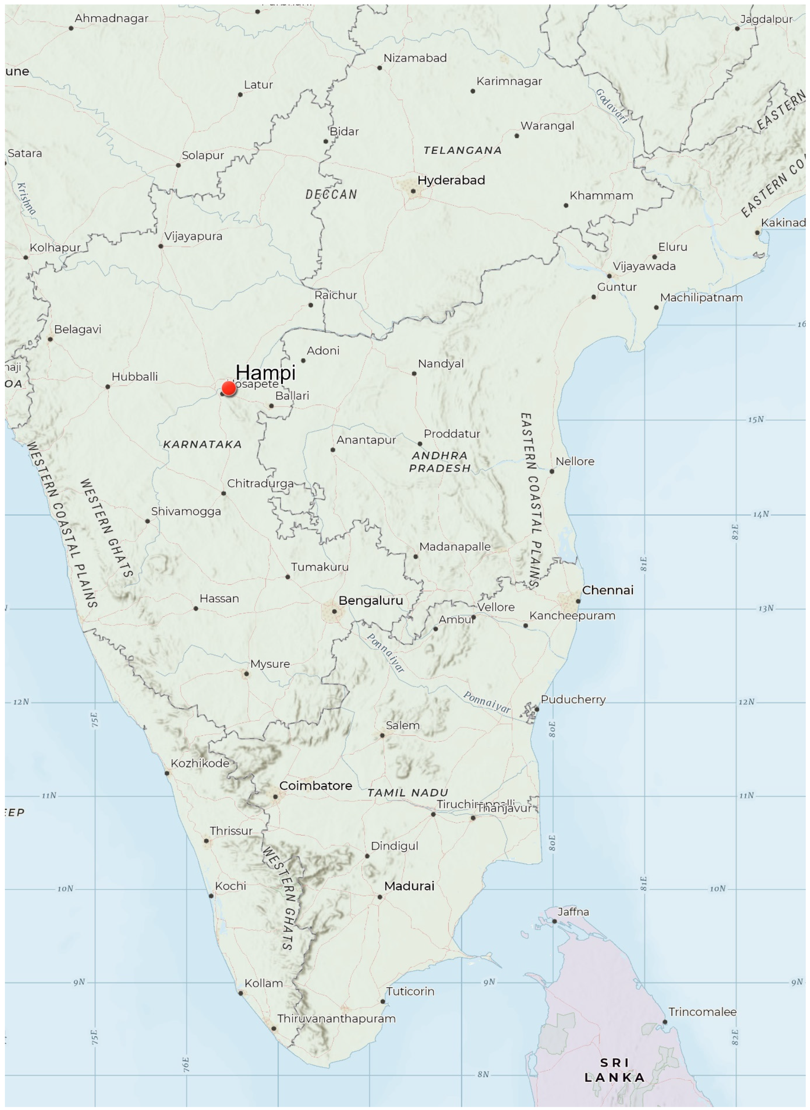
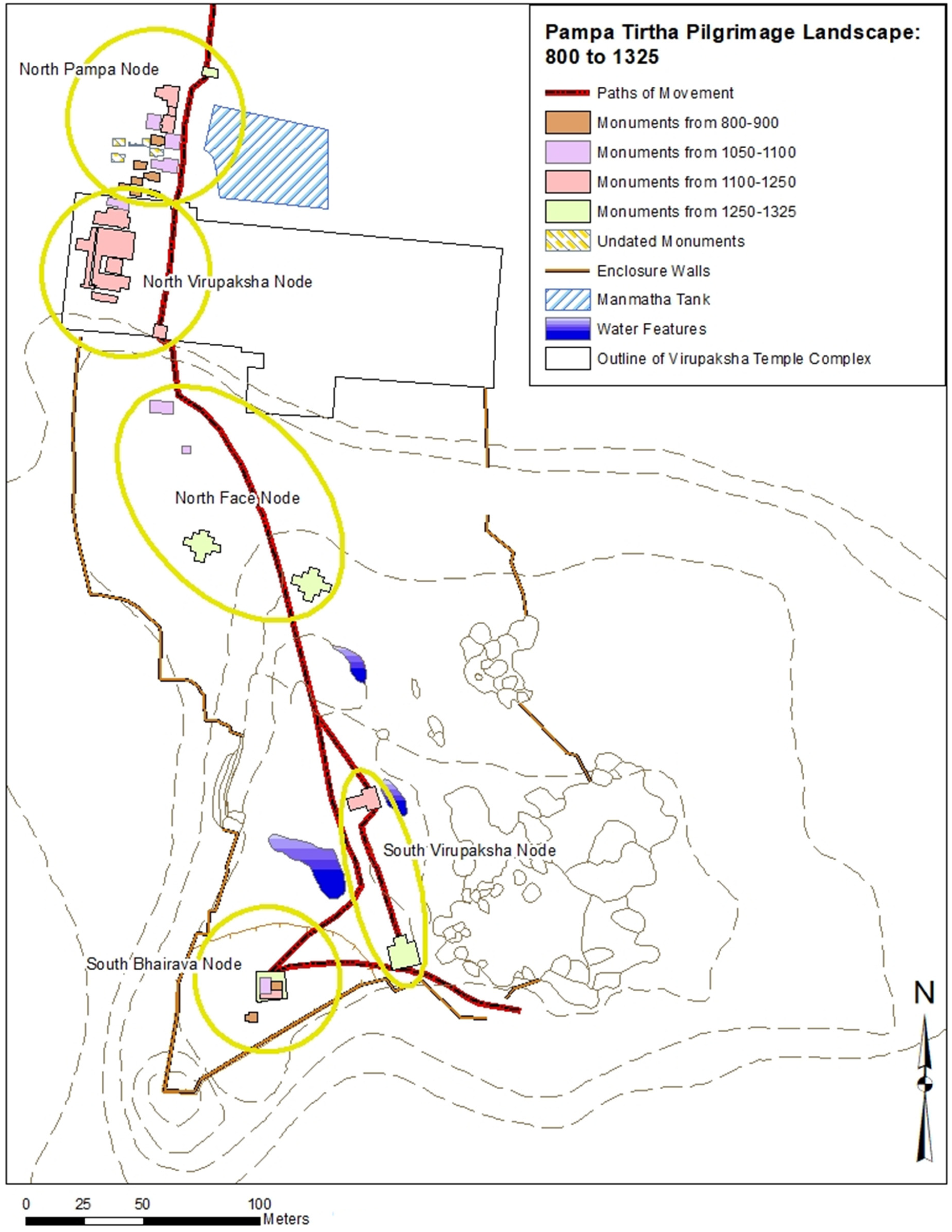
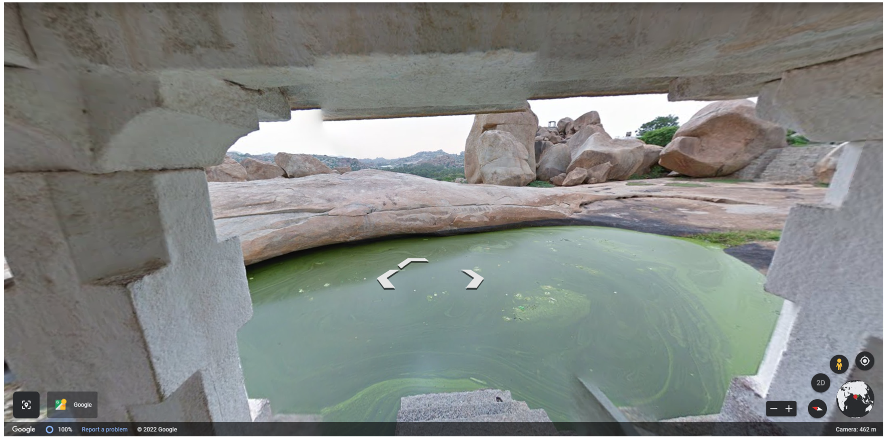
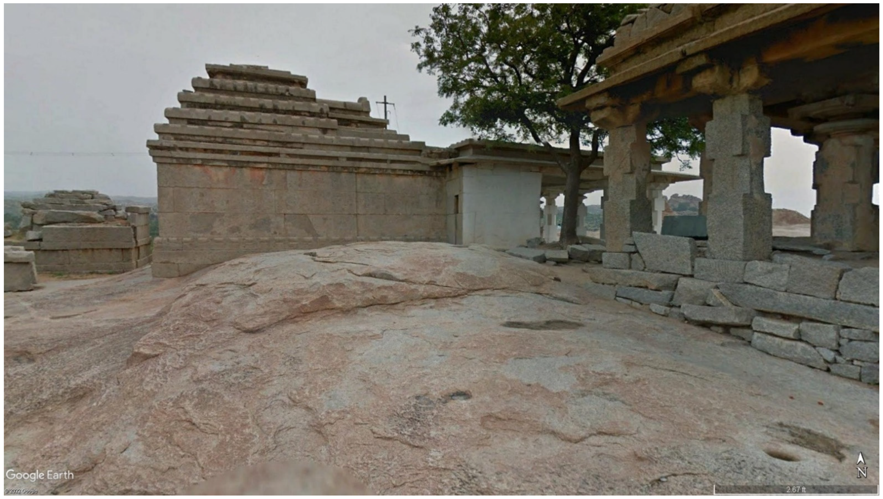
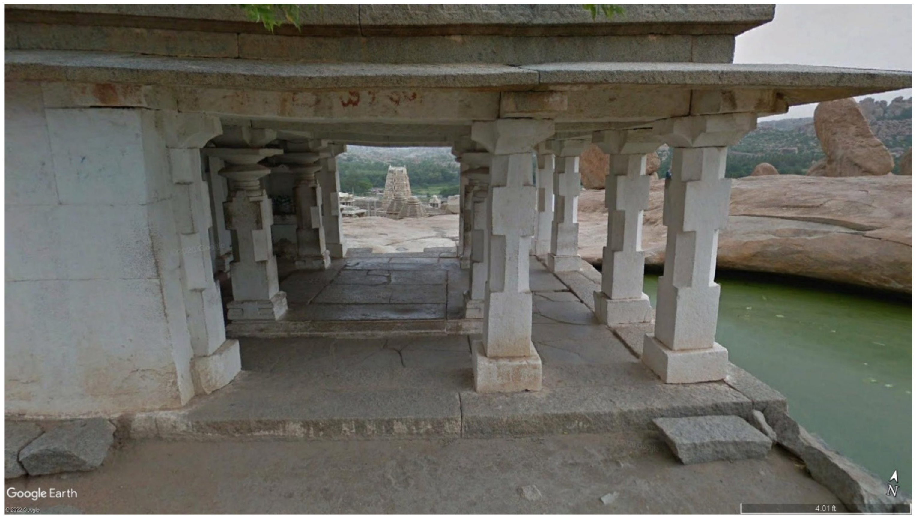
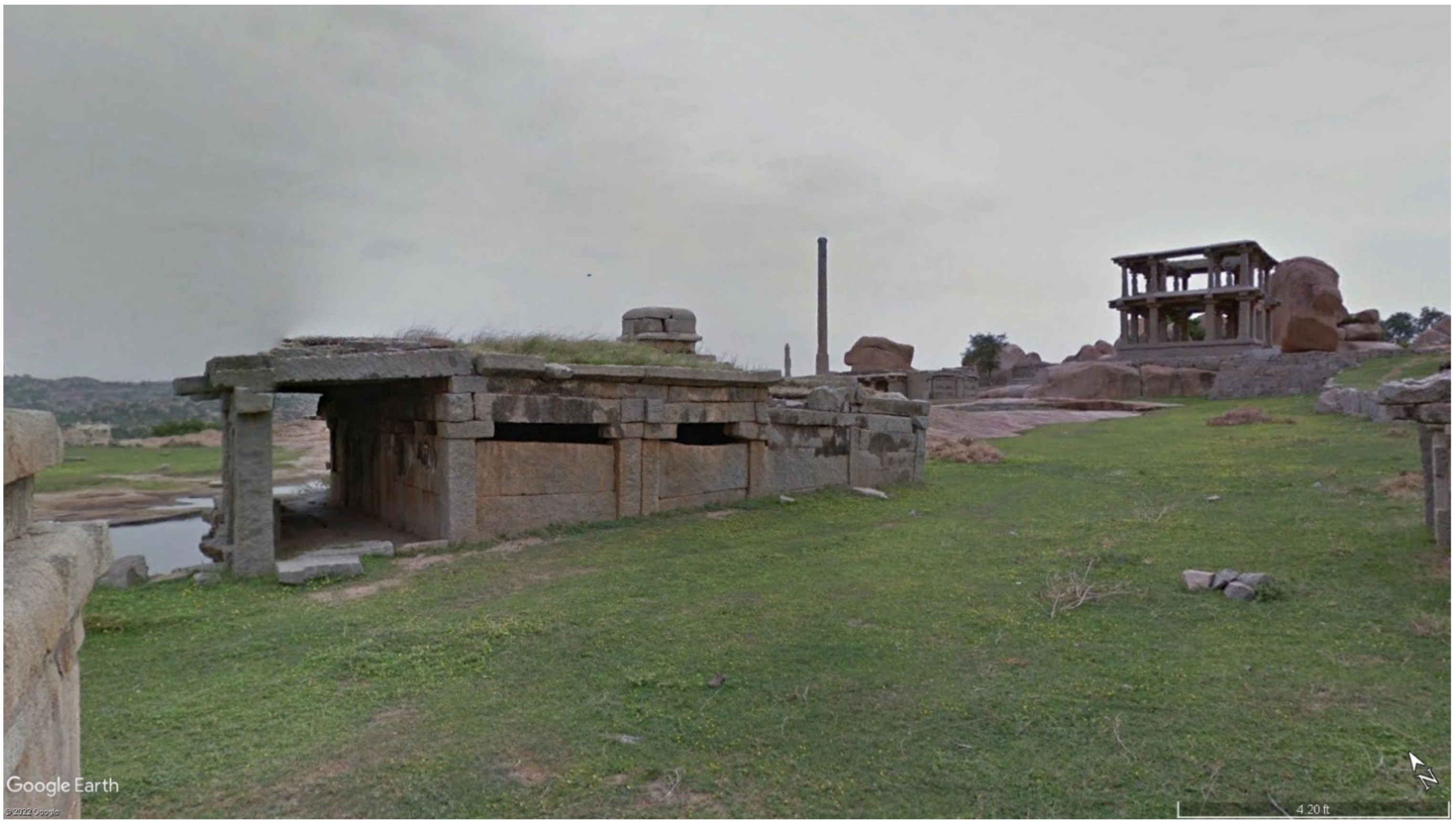
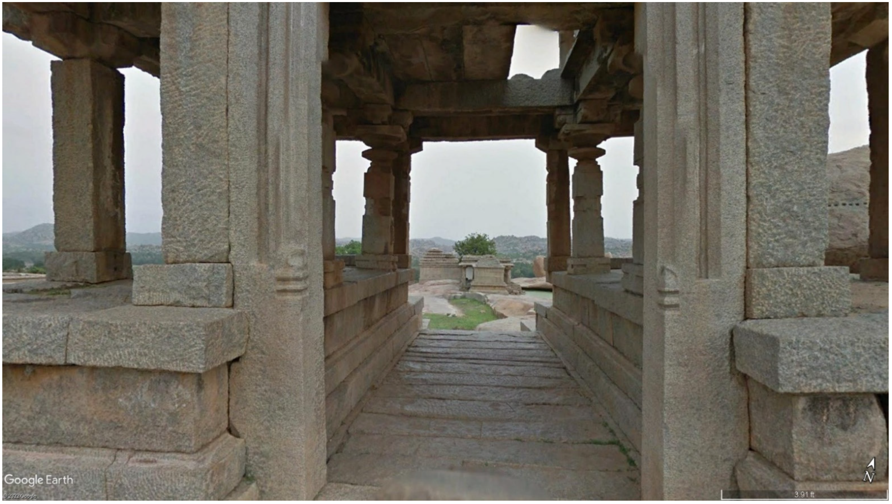
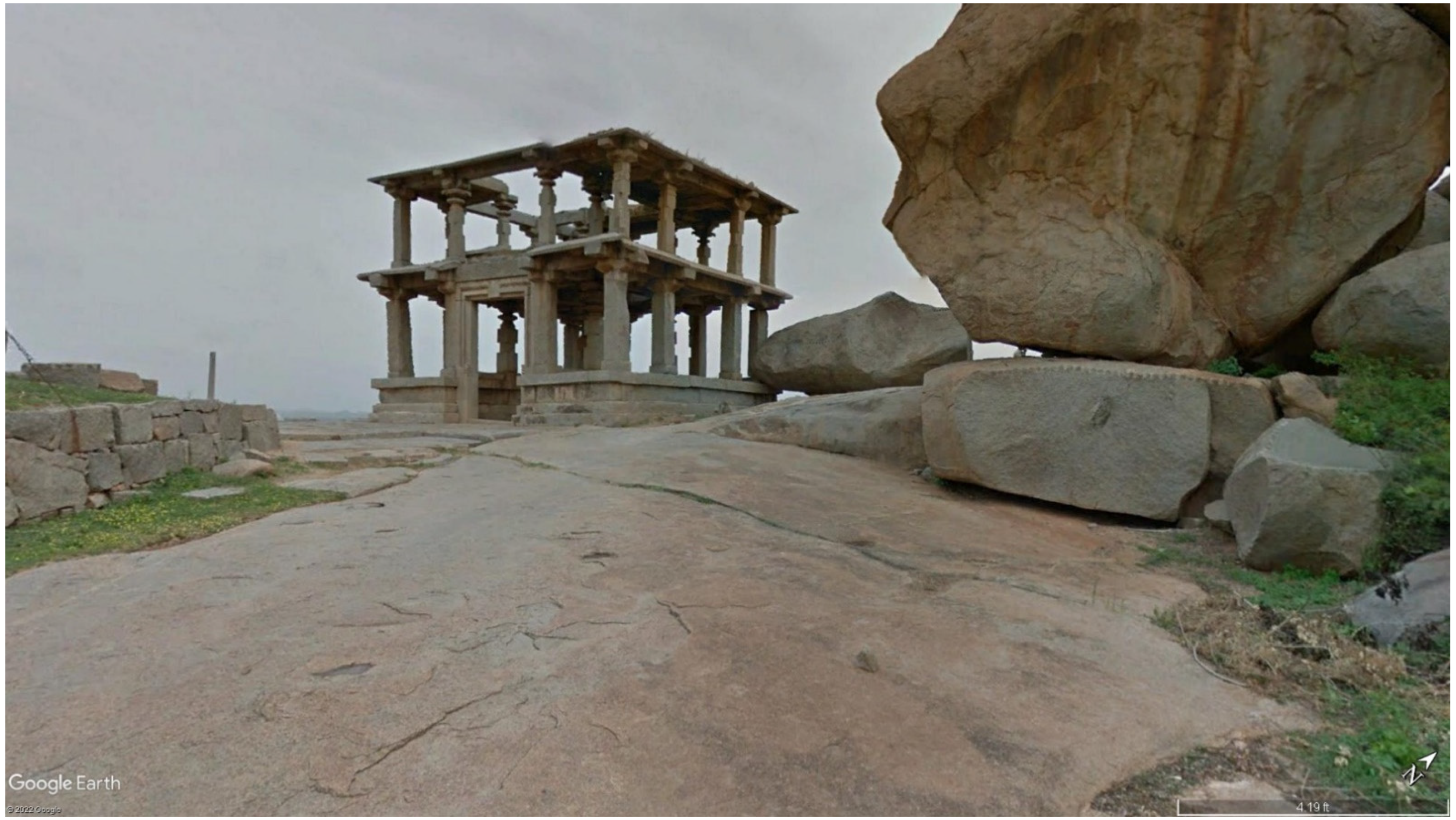
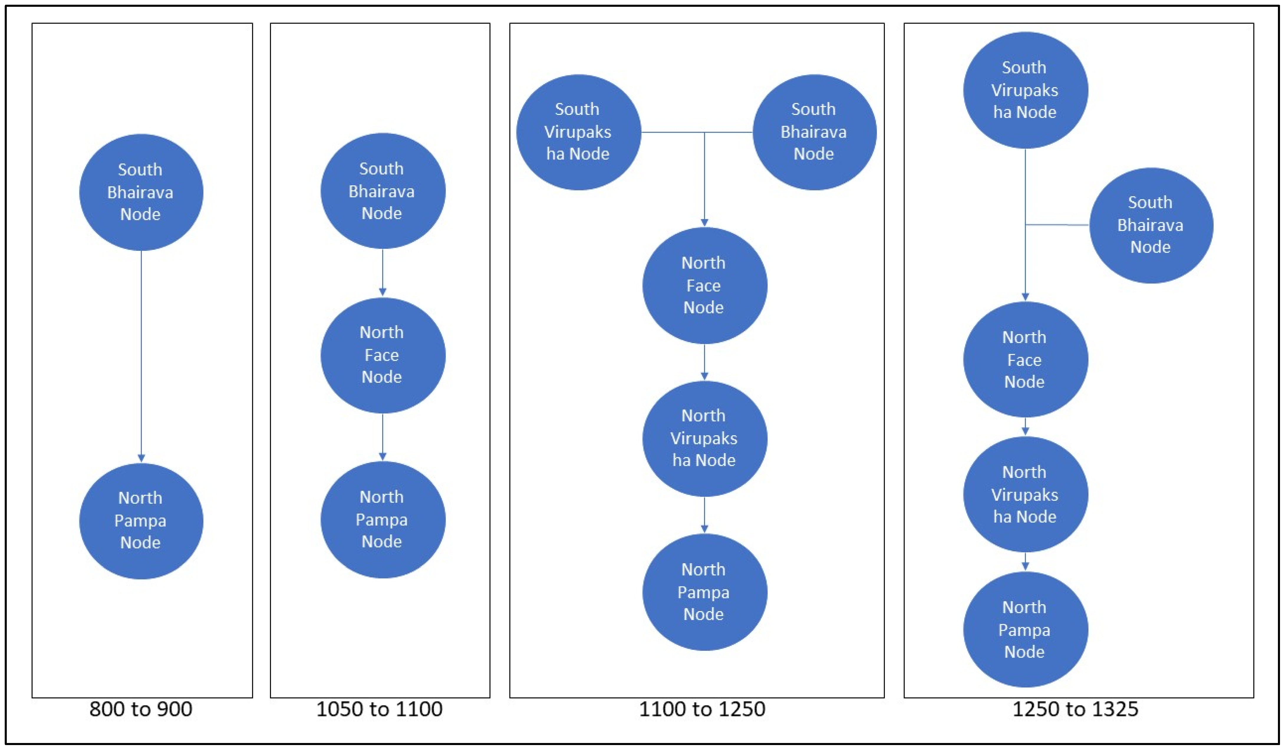
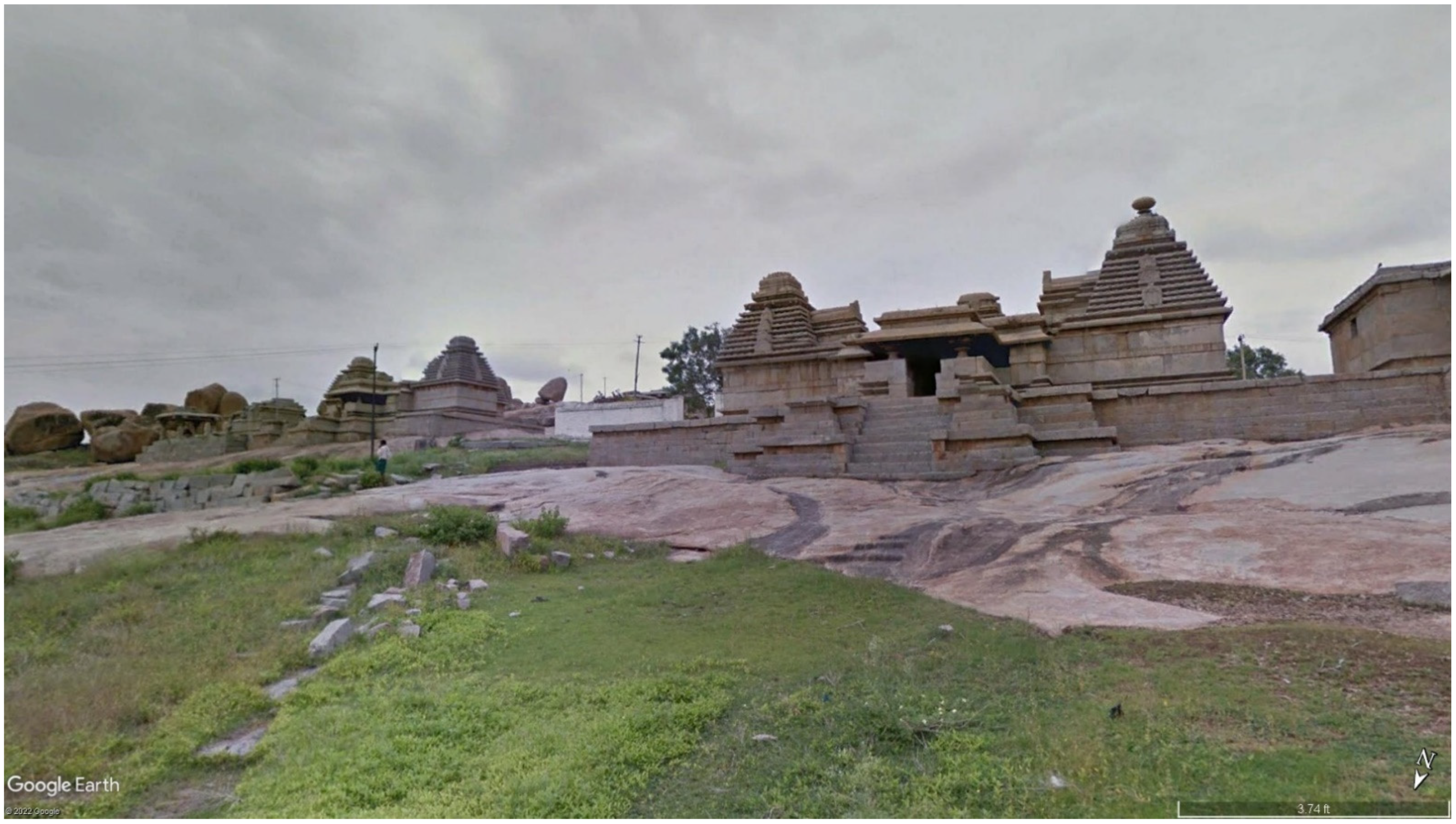