1. Introduction
Archaeological sites are unique sources of information on paleoenvironments and human-nature interactions at all stages of development of human society [
1,
2,
3,
4,
5,
6,
7]. Pedogenetic study of archaeological sites makes it possible to compile valuable interpretations of the early stages of the history of settlements and to characterize the stages of site evolution [
8,
9,
10,
11,
12,
13,
14,
15]. This is especially important in case when archaeological materials are lacking within pedosedimentary layers.
The first urban construction of the 14th century was discovered in the eastern part the Moscow Kremlin area within the ravine that cut through the slope of Kremlin Hill facing the Moskva River. It was built during the reign of Dmitry Donskoi most probably after the construction of the white-walled Kremlin and by the 15th century such constructions had covered the entire hillslope. Prior to this the area was used as a farmland [
16]. In 17th century the site had housed two ancient religious institutions of the Kremlin—the Holy Miracle Monastery of Archangel Michael and the Convent of The Risen Lord. In 1929–1932 the main cathedrals of these two institutions had been totally destroyed during the construction of administrative buildings but the basement cellars of the recent building preserved the remains of the cathedral foundations. The administrative building of the Soviet time was demolished in 2016–2017 that opened the best-preserved sequence of cultural layers of the 12th–17th centuries underlain by paleosols that contained archaeological findings of fragmented ceramics dating back to the Early Iron Age (1500–2000 years BP) [
17]. The study of this site made it obvious that the eastern part of the Kremlin Hill was used by people of the Early Iron Age, whose settlement was found at a distance of about 200 meters from the site, closer to the river.
The goal of the present study is to characterize the early (pre-urban) stages of human occupation within the eastern part of the Moscow Kremlin and provide paleoenvironmental reconstruction for various stages of land use. The evolution of buried soils after the site was abandoned by inhabitants is also provided.
2. Materials and Methods
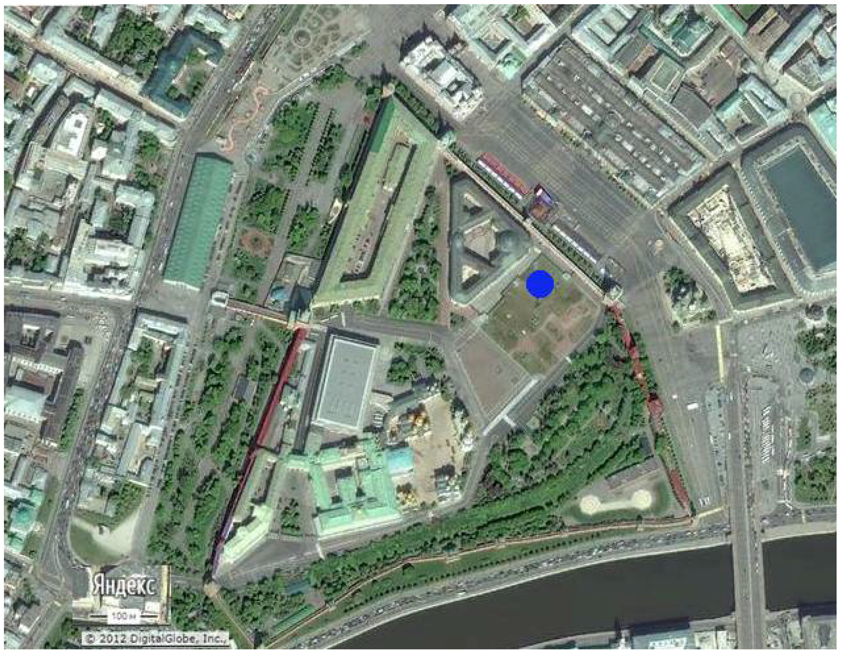
The study site (55°45.12′ N, 37°37.06′ E, 149.2 m a.s.l.) is located within Moscow Kremlin, the historical centre of Moscow City (
Figure 1). Topographically, the site is situated on the 3rd fluvioglacial terrace of the Moskva River [
18].
Moscow City is characterized by a temperate continental climate with a mean annual temperature of +4.5 °С, mean temperatures of January and July of −6.7 °С and +19.2 °С, respectively, a mean annual precipitation of about 650 mm, with more than 300 mm falling during the growing season and mean annual precipitation/evaporation ratio is about 1 [
18]. Natural vegetation is presented by coniferous and broad-leaved forests, with Retisols in loamy sediments and Podzols in sandy parent material [
19].
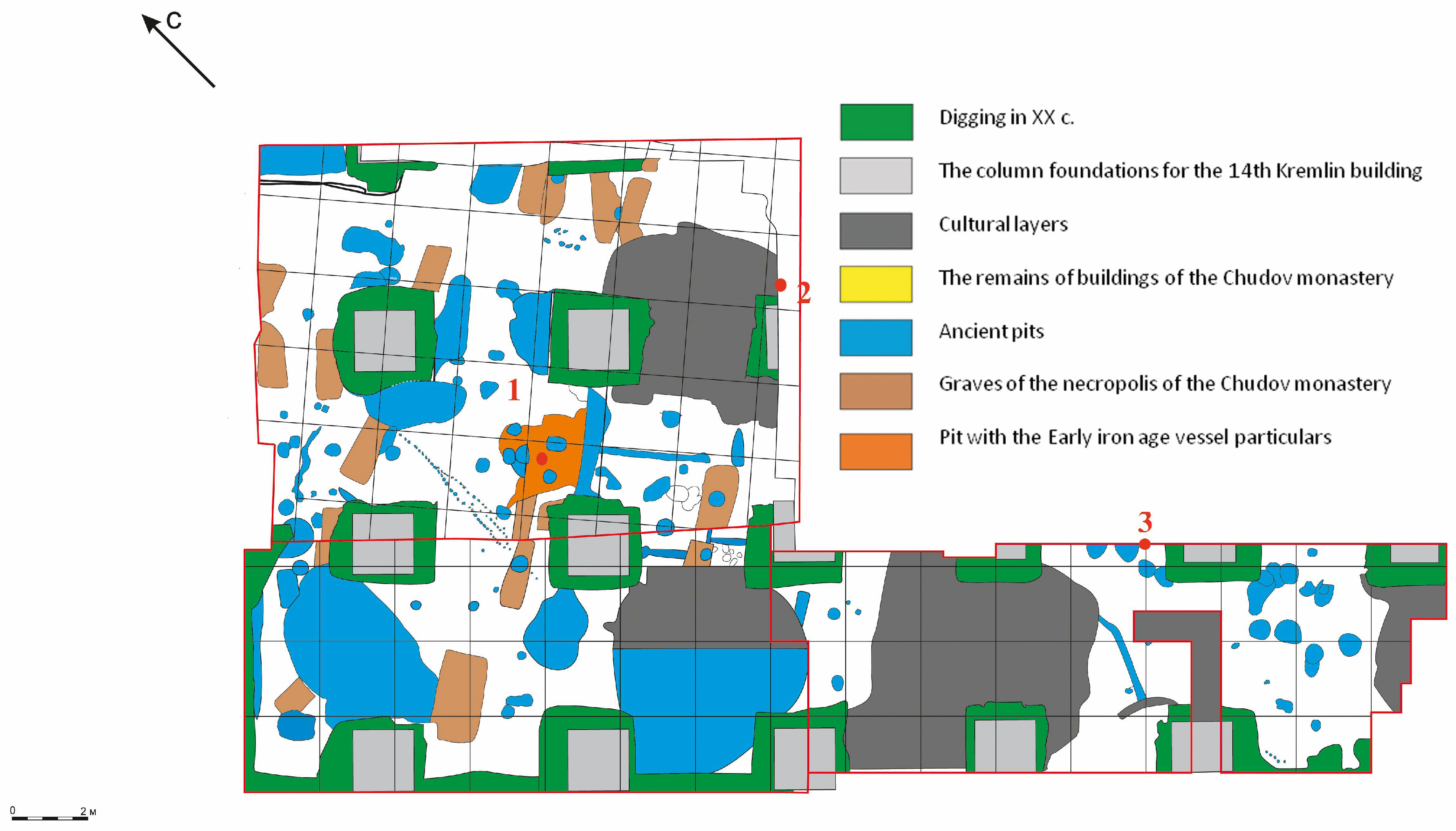
The present study on buried soils and cultural layers was conducted during the archaeological excavations within the eastern part the Moscow Kremlin area, based on several pits within the excavation location of ‘Block 14’ (see
Figure 1). In each of the pits profiles with cultural layers and paleosol horizons were described in the field and sampled along vertical columns for laboratory analyses. In this paper we present and discuss the results obtained from three profiles (or pits in further text) (with their archaeological coordinates specified in brackets): Pit 1 (Excavation 2, Phase 1, Square 1), Pit 2 (Excavation 2, Phase 2, Square 24) and Pit 3 (Excavation 3, Phase 2, Square 11) (
Figure 2).
Pit 1 was selected as the main object of the study due to it having the most clearly expressed morphological features of CLs and buried soils. Samples from this pit were subjected to the following additional analyses: calcium carbonate (CaCO3) content, particle-size distribution, macro- and microelement concentrations, palynological analysis and also, in the lower horizons of Pit 1, micromorphological analysis.
Morphological description of cultural layers and buried soils are given according to the FAO Guidelines for Soil Description [
20].
Analytical studies were performed using conventional techniques as described below.
Grain size analysis of the fraction <1 mm was made by conventional pipette method [
21] to appropriate texture classes. Particle size distribution was analysed for the Russian conventional fraction groups (
Table 1). Textural classes were determined according to the FAO Guidelines for soil description [
20].
pH
H2O was determined using a potentiometer, in suspension with soil to water ratio of 1:2.5, after a single shaking followed by settling for 30 min [
22].
Organic carbon content was determined by the Tyurin method, which included the wet combustion of organic substance in a mixture of 0.4 N K
2Cr
2O
7 and concentrated H
2SO
4 (1:1) at 150 °C for 20 min. The measurements were performed by photometry on a SPECOL 211 spectrometer at 590 nm [
22].
Total phosphorus determination included combustion of a sample with concentrated sulfuric acid. Phosphate in the extract was determined calorimetrically using a SPECOL 211 spectrophotometer (Analytik Jena AG, Germany) and a blue ammonium molybdate method with ascorbic acid as a reducing agent [
23,
24].
Calcium carbonate (CaCO
3) content in samples was determined by alkalimetry using the Kozlovskii procedure. A soil sample was treated with 2 M HCl; the released CO
2 was absorbed by a 0.4 M NaOH solution. Then a saturated BaCl
2 solution was added to the tube with NaOH and the excess of alkali was titrated with 0.2 M HCl [
24]. The obtained values of the carbonate ion concentrations were recalculated for calcium carbonates.
The concentrations of macro- and microelements (bulk composition and trace elements) were determined by X-ray fluorescence (XRF) analysis using an Axios mAX sequential (wavelength dispersive) vacuum spectrometer (PANalytical Company, Almelo, Netherlands, 2012) in the Laboratory of the Mineral Matter Analysis, Institute of the Ore Geology, Petrography, Mineralogy and Geochemistry, Russian Academy of Sciences (Moscow, Russia).
Micromorphological analysis of samples with undisturbed structure from four horizons of the buried soil (Pit 1) (black points on
Figure 3) was conducted after preparation of thin sections with the use of a polarizing microscope (Carl Zeiss AG, Oberkochen, Germany) at the Centre of Common Facilities, Institute of Physicochemical and Biological Problems in Soil Science, Russian Academy of Sciences located (Pushchino, Russia). Descriptions of these sections are based on Stoops’ terminology [
25].
Phytolith analysis is the consecutive study of the different types of plant silica particles under a microscope [
26]. Fifty-gram samples were treated with a 30% solution of hydrogen peroxide and then separated from quartz and other mineral grains by flotation in heavy liquid with a specific gravity of 2.3 g/mL (mixture of cadmium iodide and potassium iodide solutions). After centrifugation, the floating siliceous and organic microbiomorphs were collected and washed several times with distilled water, then immersed in oils (glycerin). Slides were prepared and analysed under an Olympus BX51 TL RL optical microscope (Tokyo, Japan) at magnifications ranging from 400× to 900×. The photoliths were identified and counted. The data obtained on phytolith assemblage composition in different samples were used for the analysis of the quantitative distribution of phytoliths along the column studied according to [
27].
Palynological analysis was conducted at the Laboratory of Natural Science Methods, the Institute of Archaeology, Russian Academy of Sciences (Moscow). Pollen samples were prepared using the refined separation technique by V.P. Grichuk [
28]. Firstly, soil samples were pre-treated by a hot 10% HCl solution, rinsed in distilled water and boiled in 10% solution of alkali. Then, pollen and spores were separated by centrifuging in heavy liquid (same as used in phytolith analysis, see above). The sediment obtained was diluted with glycerine and the slides prepared were analysed using a Primo Star light transmission microscope (ZEISS, Germany). The palynological analysis was conducted at a magnification of 400 and involved identification and counting of three groups of biomorphs according to [
29]: (1) pollen of trees and shrubs; (2) pollen of undershrubs and herbs and (3) spores.
3. Results
3.1. Morphological Description
The three studied pits are characterized by similar profiles (
Figure 3) with a series of cultural layers of different thicknesses, colours and compositions underlain by buried soil. The buried soil has a shallow anthric horizon due to arable or garden cropping.
The boundary between the brickwork of the ancient cathedral’s foundation and the underlying CL was set as the zero level in descriptions of all the pits. In the description we indicated the cases when buried soil horizons are developed within cultural layers.
3.1.1. Pit 1 (Excavation 2, Phase 1, Square 1)
Cultural layers (0–17 cm). A sequence of cultural layers of different colours, with inclusions of small fragments of medieval ceramic and charcoal particles. Sandy loam. Carbonate gravel is abundant in the upper 5 cm.
2Cte (17–18 cm), technic material with abundant fragments of limestone of different sizes. Abrupt transition and smooth boundary.
Ahb1 (18–19 cm). Pyrogenic horizon. Dark grey. Consist almost entirely of large charcoal particles, [
17]).
3С (19–25 cm) Brownish grey, loamy sand with gravel, free of archaeological finds.
Cultural layers (25–47 cm). A sequence of cultural layers of different colours, with inclusions of small fragments of medieval ceramic and charcoal particles. Sandy loam.
Ahb2 + cultural layer (47–48 cm). 10YR 4/2, dark brown, silt loam, weak crumby structure, the thickness varies between 0.5–2 cm, the upper and lower boundaries are slightly wavy and abrupt.
Ahb3 + cultural layer (48–53 cm). 10YR 4/3, grey with brownish hues, silt loam, weak crumby structure, with a slightly wavy lower boundary marked by a thin diffuse brown stripe.
4C 53–57 cm. Light-brown, loose, sandy loam with gravel, with smooth boundary.
5Apb (57–60 cm). The lower part of truncated plough layer. 10YR 4/2, dark brown. Silt loam, weak crumby structure. Abrupt irregular lower boundary.
5Eb (60–65 cm). A lower part of Albic horizon not touched by ploughing. 10YR 6/2, light brownish grey, silt loam. Weak platy structure, gradual smooth boundary.
5Bsb (65–70 cm). 10 YR 5/4 yellowish brown, silt loam, firm, gradual smooth boundary.
6BCb (70–85 cm). 6 YR 6/3, pale brown, silt loam, with dark loamy stripes (7,5 YR 4/3, brown), friable.
Archaeological finds: A single small fragment of ceramic dated back to the Early Iron Age (2000–1500 BP) was found within the 60–65 cm layer. The above deposits were medieval (the 12th–13th centuries).
3.1.2. Pit 2 (Excavation 2, Phase 2, Square 24)
Cultural layers (0–32 cm). A sequence of three cultural layers of different colours: the upper and the lower ones are mostly dark with thin brown intercalations and inclusions of fine gravel. The middle layer is light brownish grey, with small charcoal particles and fine gravel. The two upper layers have smooth and abrupt boundaries. The lower cultural layer is characterized by common charcoal particles and a wavy lower boundary.
Apb (32–38 cm). A buried plough layer. Light grey, sandy loam with gravel, firm, with abrupt smooth boundary.
Bsb (38–48 cm). 10 YR 5/4 yellowish brown, silt loam, firm, gradual smooth boundary.
BCb (48–60 cm). 6 YR 6/3, pale brown, silt loam, with dark loamy stripes (7,5 YR 4/3, brown), friable.
Archaeological finds: All artefacts found in this pit are medieval.
3.1.3. Pit 3 (Excavation 3, Phase 2, Square 11)
Cultural layers (0–32 cm). A sequence of cultural layers of different colours and densities, with a clear, slightly wavy lower boundaries.
Apb 32–34 cm. The lower part of truncated plough layer. 10YR 4/2, dark brown. Silt loam, weak crumby structure. Abrupt irregular lower boundary.
Eb (34–36 cm). A lower part of Albic horizon not touched by ploughing. 10YR 6/2, light brownish grey, silt loam. Weak platy structure, friable. With fine iron nodules. Gradual smooth boundary.
Apb2 (36–50 cm). An ancient plough layer, light grey silt loam, firm, abrupt smooth lower boundary.
Bb (50–70 cm). 6 YR 6/3, pale brown, silt loam, firm, with gravel.
Archaeological finds: Small fragments of ceramic of the Early Iron Age in the lower part of the 36–50 cm layer.
3.2. Micromorphological Description (Pit 1)
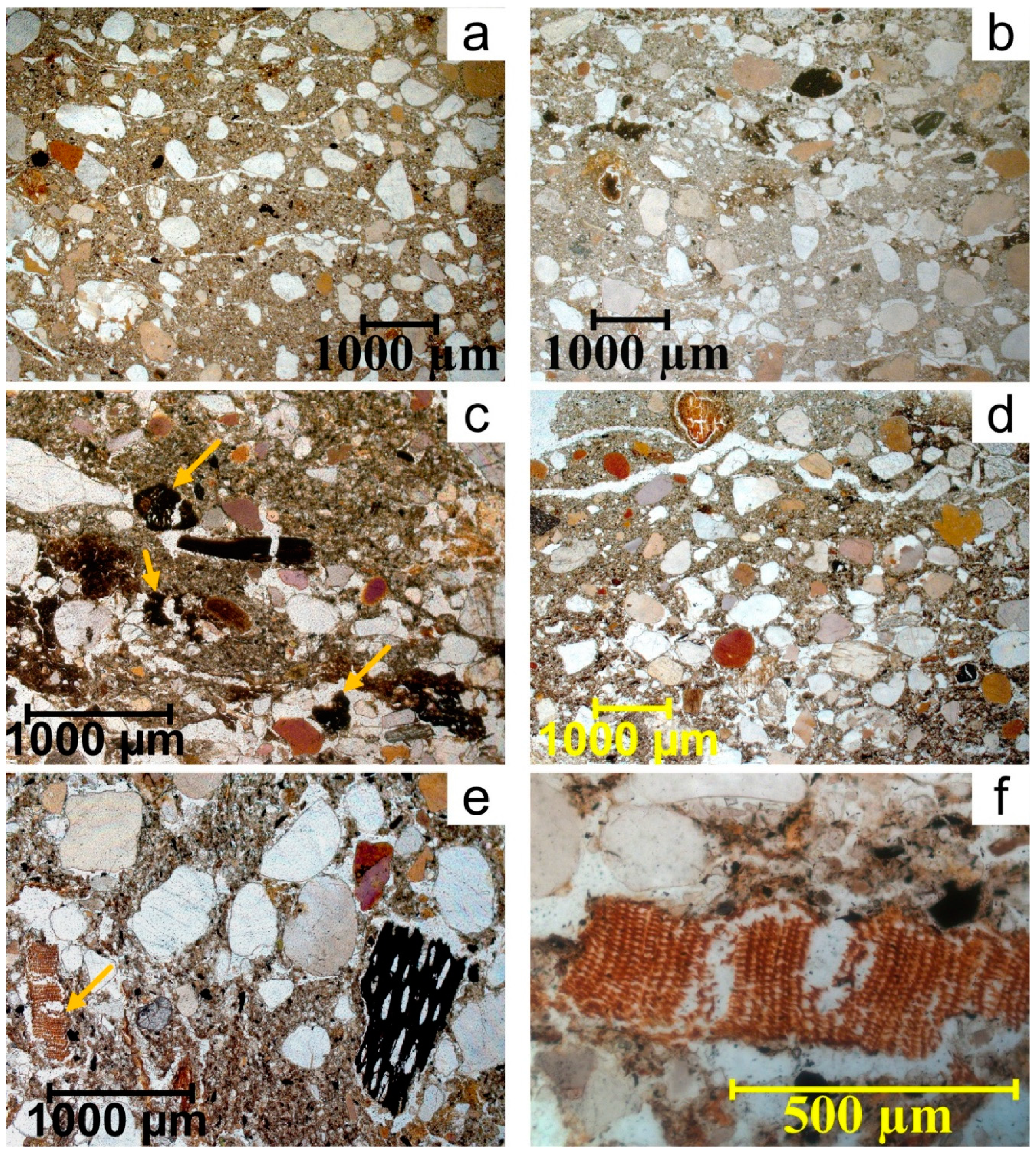
Truncated plough layer Apb4 (57–60 cm) is characterized by a platy microstructure, with a series of parallel fissures in the groundmass (
Figure 4a) and a presence of microlayers enriched in charcoal (
Figure 4b). The charcoal particles are different in size and patterns, originated from burned wood and occasionally grass. The grass charcoals had more irregular shapes and indistinct patterns of plant tissues (
Figure 4c, marked by arrows) as compared to wood charcoals (
Figure 4d). All mineral grains at the lower part of Apb horizon are covered by iron-humic-argillic coatings, uncoated sand grains are absent. Iron nodules and mottling indicate gleying at the contact between the plough layer and Albic horizon. The plough layer contains not only charcoal but also small fragments of bones and very small fragments of plant tissue residues with distinct weaved patterns (
Figure 4e,f). There are also inclusions of very small elongated fragments of lithogenic carbonates (calcareous rocks), hardly visible under plane polarized light (PPL). The Albic horizon (Eb, 60–65 cm) does not have either parallel fissures or a platy microstructure.
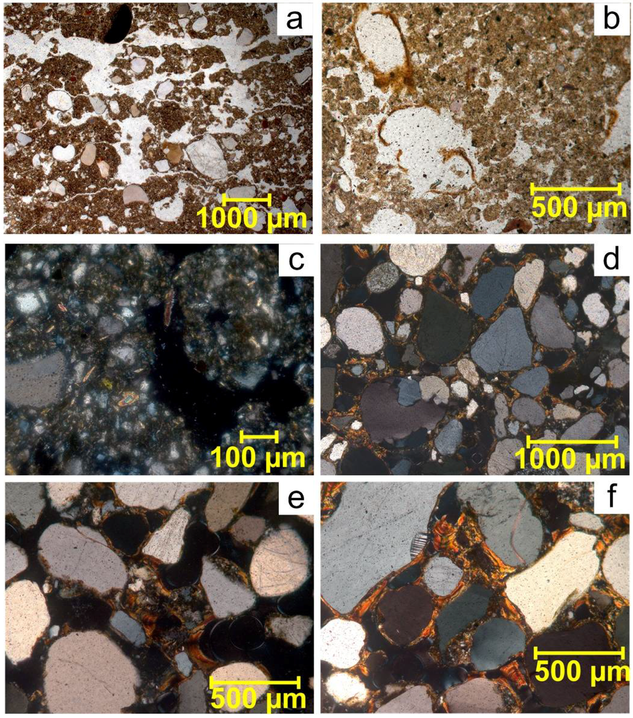
Spodic horizon (Bs, 65–70 cm) has platy-vermicular microstructure with bioturbation features (
Figure 5a). Distinct parallel fissures and weak platy peds are disturbed by soil mesofauna. Strongly decomposed plant residues and vermicular microstructure within microzones of soil disturbance by mesofauna are also visible at a higher magnification (
Figure 5b). Elongated and, sometimes, rounded fragments of lithogenic carbonates sporadically distributed within finely dispersed material (
Figure 5c).
The 6BCb horizon (70–75 сm) shows lithic discontinuity (sand grains here are larger than those in the Albic and Spodic horizons). It is characterized by the gefuric c/f related distribution (
Figure 5d,e), where sand and silt grains are bound by bridges that are formed by iron coatings. Pore walls are covered by iron and argillic coatings. The coatings are thin, laminated and sometimes crescent-laminated (
Figure 5f). This layer is free of limestone fragments.
3.3. Analytical Properties
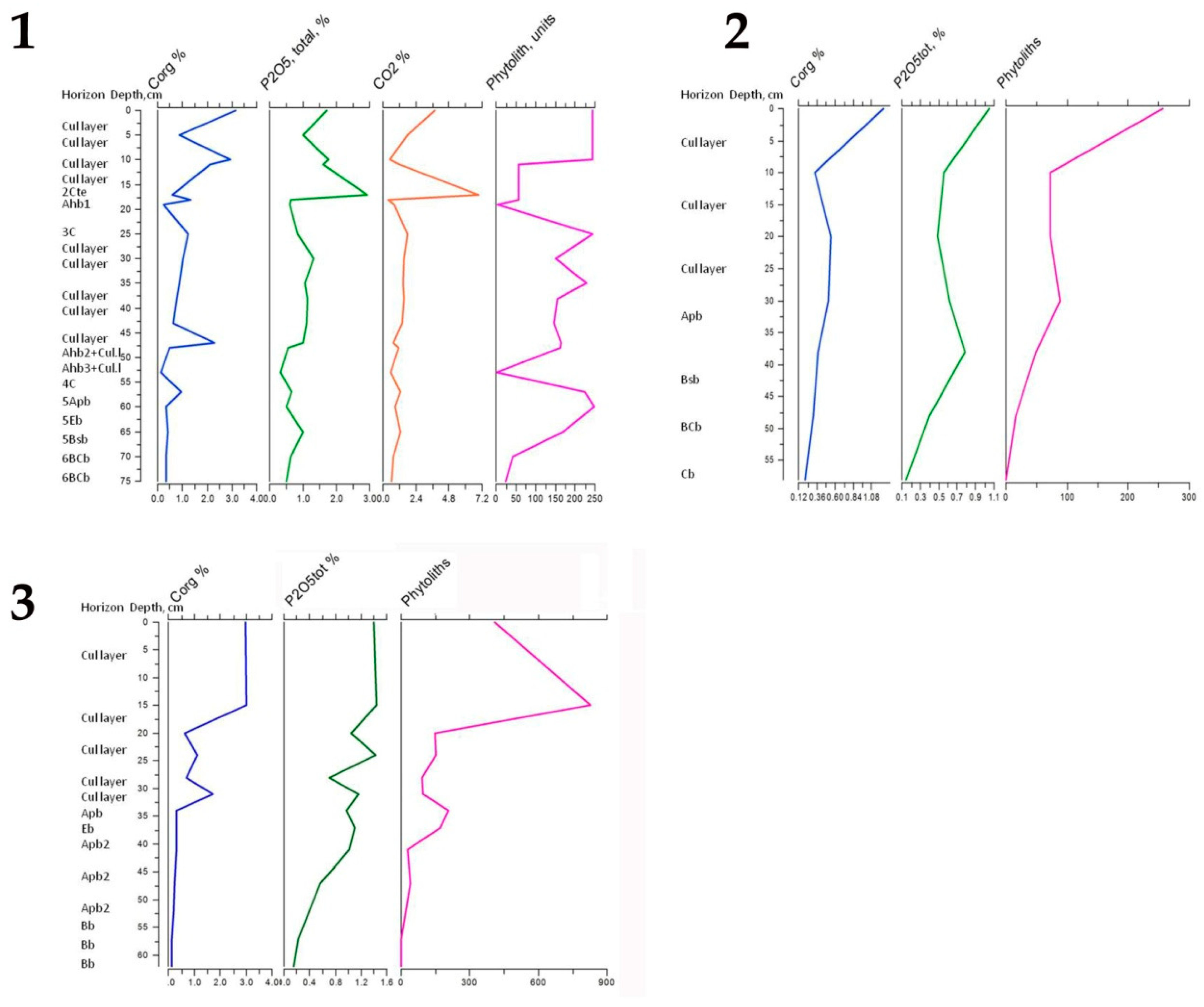
Both cultural layers and buried soils are developed in sandy loam and loamy sand intermixed with sand layers (
Figure 6). The lower horizons are less sandy and more silty (silt loam).
All cultural layers and soil horizons in three pits has neutral pH (
Table 1). The content of organic carbon (
Table 1,
Figure 7) differs considerably. For instance, there is a considerable increase in organic carbon in Ahb2 and 5Apb horizons of Pit 1. The same in Apb horizon in Pit 3. The distribution of total phosphorus (P
tot) follows the distribution of organic carbon (
Table 1,
Figure 7). However, there are also some differences, particularly, high values of P
tot, observed in the buried Spodic horizons of Pit 1 and 2, as well as in the plough layer of Pit 3 (Apb2, 37–41 cm) does not correspond to the high values of organic carbon.
The CaCO
3 content in Pit 1 is high within the uppermost (0–5 cm) and lower (17–18 cm) cultural layers, where abundant limestone fragments of different sizes are recorded during field studies (
Table 1,
Figure 7). Low CaCO
3 content are detected in the cultural layer at the 10–11 cm depth, the charcoal-rich pyrogenic horizon (18–19 cm), 4C (53–57 cm) and 6BCb horizons. A higher carbonate content within the 5Bsb (65–70 cm), will be discussed below (see Discussion).
3.4. Concentrations of Macro- and Microelements (Bulk Composition and Trace Elements) (Pit 1)
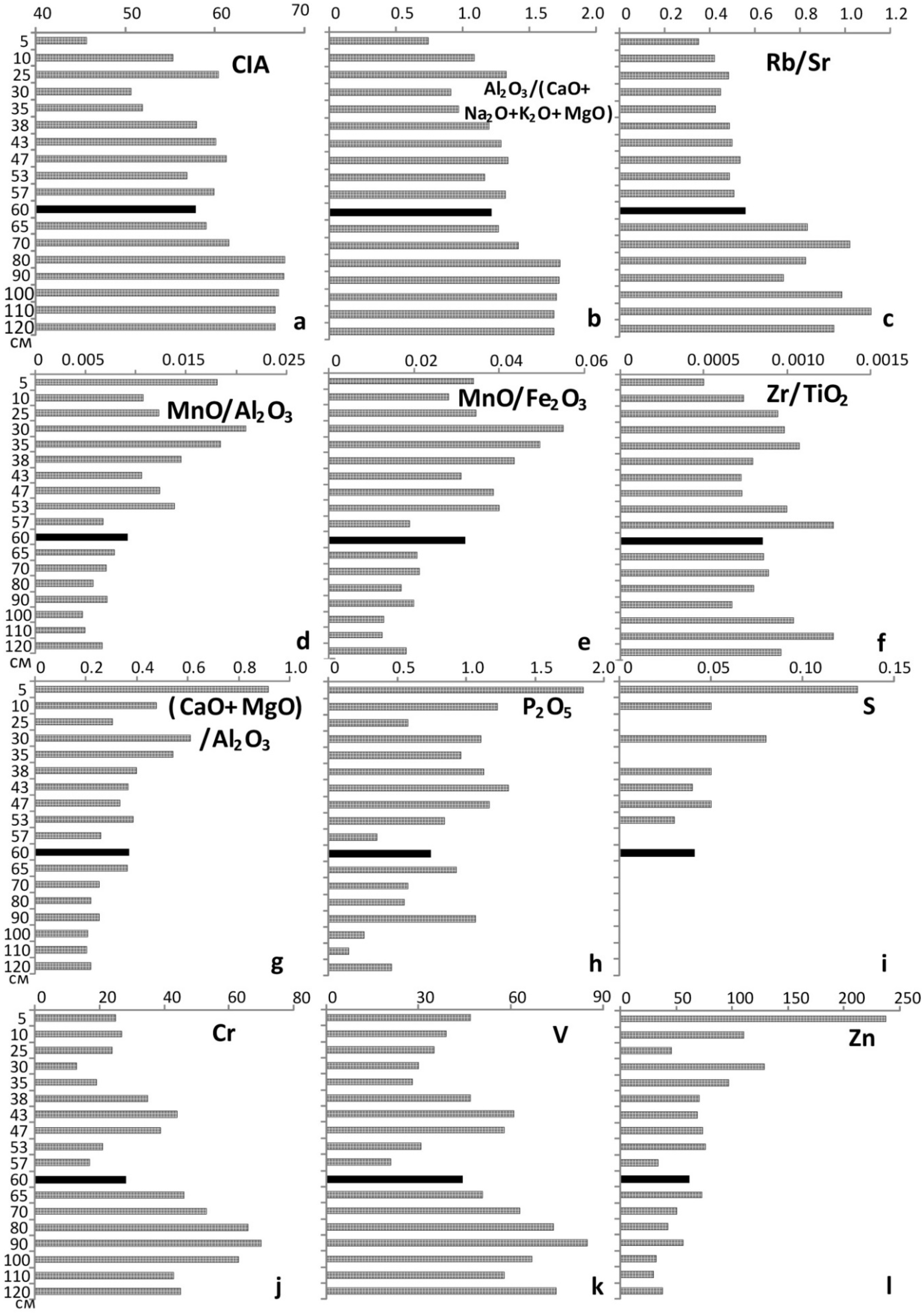
Firstly, bulk composition data allowed us to calculate mineral weathering indices, which showed the relative proportions of elements with different leaching rates, that is, more weatherable base cations of Ca, Mg, K and Na and less soluble Al. The Chemical Index of Alteration (CIA) was calculated as a ratio of Al
2O
3 to the sum of Al
2O
3 + CaO + Na
2O + K
2O multiplied by 100, where CaO was of non-carbonate origin (
Figure 8а). The other index of weathering was calculated as a ratio of Al
2O
3 to the sum of СаO + МgO + К
2O + Na
2O (
Figure 6b). According to [
30], these geochemical indices reflect the degree of transformation of feldspars and micas (primary minerals) into clay (secondary) minerals, based on the assumption that feldspars and micas are the most frequently occurring soil minerals. In the present study, it was established that such indices were widely variable between CLs within the upper 0–57 cm part of the studied profile (Pit 1, where the first horizon of buried soil (5Apb), 57–60 cm, is marked in black colour in all diagrams), with their minimal values found at the depths of 0–5 and 25–30 cm. The three buried soil horizons including 5Apb (57–60 cm), 5Eb (60–65 cm) and 5Bsb (65–70 cm) had significantly lower indices (CIA by c.10 units lower and the other index—by 0.5 units lower) than the 6BCb horizon at the bottom of the profile. The vertical distribution of weathering indices had a negative correlation with that of organic carbon, that is, minimal values of indices were found within the layers of maximal concentrations of Corg. In our opinion, this resulted from the presence of biophilic elements (Ca, Mg, K and Na) within humus horizons and their absence in lower subsoil horizons.
The Rb to Sr ratio can also be considered as a weathering index, because it reflects differences in the weathering rates of micas and feldspars (mineralogically associated with Rb) in comparison with carbonates (associated with Sr) [
31]. The Rb/Sr ratio clearly indicated that carbonate contents in CLs were higher than those in buried soils (
Figure 8c). This ratio had a clear negative correlation with the (СаО + MgO)/Al
2O
3 index (
Figure 8g), which also reflects carbonate accumulation and migration [
32]. Together these ratios indicated the human-induced accumulation of carbonates within CLs, which confirms conclusions from many previous studies.
Indices of oxidation (MnO/Al
2O
3 and MnO/Fe
2O
3) characterize the biological activity and biological productivity levels in automorphic (free-drained) soils and oxidation levels in hydromorphic (waterlogged) soils [
33]. In the pit studied, the oxidation indices were generally high in all CLs and particularly high in the CLs at 0–5, 30–35 and 35–38 cm depths (
Figure 8d,e), which was indicative of their formation under hydromorphic conditions. At the same time, the oxidation indices of buried soils were much lower, which showed that pedogenesis had mostly an automorphic character. Slightly increased oxidation indices within the upper horizon of buried soil resulted from its higher biological activity and biological productivity.
The Zr/Ti ratio characterizes the degree of homogeneity of sedimentary materials [
34]. In the pit studied, the Zr/Ti ratio values were evenly distributed throughout the profile (
Figure 8f), with a local maximum within the sand deposit (53–57 cm) and a local minimum within the uppermost CL (0–5 cm). These values showed accumulation/removal of substances that resulted, probably, from anthropogenic impact.
Individual element concentrations can be used as indicators of anthropogenic impact like the indices considered above. In particular, the total phosphorus concentrations were generally high in CLs and generally low in buried soils (
Figure 8h). Local maxima of P
tot. in some layers of buried soils were associated with anthropogenic impact. The same layers were characterized by inclusions of charcoal particles and small fragments of bones. The CLs were also characterized by the presence of S (
Figure 8i), increased concentrations of Zn (
Figure 8l) and decreased concentrations of Cr and V (
Figure 8j,k), as compared to the composition of buried soils.
3.5. Phytolith and Palinological Analyses
Statistically significant quantities of phytoliths, pollen and spores were found in practically all the samples studied, including sediments (
Table 2,
Figure 9). However, there was an exception for lower horizons of buried soils, where microfossils occurred very rarely, so, the data could only be used for qualitative comparisons.
All three pits are similar in phytolith content and distribution. The lower layers of buried soils are dominated by phytoliths of forest flora (including coniferous trees), while the cultural layers are usually dominated by phytoliths of herbs and mosses that are rare or absent in the buried soil horizons. However, there were exceptions for several cultural layers in Pit 1 (11–19 and 38–47 cm), where forest flora phytoliths are more abundant than herb phytoliths.
It was interesting to note that phytoliths of cultural crops are present not only within cultural layers but also lower down—in arable soil horizons of Pits 1 and 3, where the Early Iron Age ceramics are found (at depths of 60–65 and 41–52 cm, respectively).
The palynological analysis for Pit 1 confirms the trends revealed from the phytolith distribution: tree pollen prevails in lower soil horizons, while pollen of herbaceous plants became dominant in the upper layers, starting from the 5Apb (57–60 cm). We find opposite patterns of quantitative distribution of moss phytoliths (decreased with depth) and moss spores (increased with depth). The distribution of pollen of cultural cereals is similar to the distribution of their phytoliths, with both types of microfossils found not only in cultural layers but also in buried soil horizons.
4. Discussion
Both morphological and analytical studies confirm that all pits are formed in sandy fluvioglacial sediments of the third terrace of Moskva River. Grain size distribution exhibit lithic discontinuity between cultural layers and soil horizons enhanced by mineral materials transported by ancient people and deposited due to slope erosion. Lithic discontinuity is also evidenced by the differences in the size of sand grains in thin sections (e.g., between Bs and 6BCb horizons in Pit 1.
Based on morphology, all buried soils are presented by truncated profiles. The soils in Pits 1 and 3 are both truncated and transformed by ploughing. Soil horizons within cultural layers of Pit 1 are not well formed. The presence of sandy layers between the cultural and plough layers as well as truncation of the upper horizons indicate erosion and additional accumulation of sediments at the early stages of human occupation.
Micromorphology confirms that the plough layer in Pit 1 (5Apb, 57–60 cm) exhibit platy microstructure typical for the plough line (the lower part of the plough layer) of arable soils in the fields and gardens. The upper part of the former plough layer was truncated. The remaining part contains microscopic particles of grass and wood charcoal, very small fragments of bones and ancient weaved textiles made of plant fibres. These finds allows offering the following interpretation of the ancient agricultural practices: burned grass turf was mixed into the soil during its tillage, wood ash and crushed bone were applied to the soil as fertilizers, while the textile fragments originated, probably, from household waste.
The micromorphological study of the contact zone between 5Apb and Albic horizons revealed the presence of iron nodules and mottling, indicating short-term waterlogging that could enhance the bleaching of Albic horizon. An increase of Mn content in the cultural layers and buried humus horizons are due to high biological activity of these layers. The Spodic horizon in Pit 1 (65–70 cm) preserve well-developed features of soil mesofauna activity, including vermicular microstructure, worm casts and a high content of dispersed humus. Obviously, the mesofauna activity was not obliterated the original platy microstructure with parallel fissures typical for the plough line of arable soils. It can be suggested that the profile of Podzol soil was developed within the former plough layer after the site was for some time abandoned by inhabitants. Based on the degree of disturbance of the platy microstructure by mesofauna, the site could be abandoned only for a few decades.
Human-induced accumulation of carbonates within cultural layers is described in the previous studies [
35,
36] The presence of micro particles of lithogenic carbonates within the plough layer, Albic and Spodic horizons could be explained by treatment of soils with a liming agent to improve their agricultural potential. The micromorphological observations are in line with chemical properties that detected high concentrations of CaCO
3 in these layers.
Both morphological and analytical studies confirm that cultural layers were formed due to man-induced accumulation of different materials including organic substances (e.g., manure and/or wood), sand and limestone. All cultural layers are characterized by increased concentrations of specific chemical elements (e.g., organic and inorganic carbon and total phosphorus). Particle-size distribution result from lithic discontinuity of fluvioglacial sediments, man-induced accumulation of various mineral materials and accumulation of sediments due to slope erosion.
Concentrations of elements can be used as indicators of anthropogenic impact. In particular, the total phosphorus concentrations is high in the cultural layers and generally low in buried soil horizons (
Table 1,
Figure 7). Local maxima of P
tot. in some layers of buried soils is associated with anthropogenic impact. The same layers are characterized by increase in charcoal particles, small fragments of bones, plant tissues and ceramics.
The cultural layers and buried soils significantly differ by macro- and microelement concentrations (bulk composition and trace elements). Cultural layers are characterized by higher carbonate content (due to application of limestone fragments in the course of agricultural use). Some cultural layers experienced waterlogging evidenced by iron nodules and mottling. The cultural layers are also distinguished by the presence of Sulphur (which is absent in buried soils) and relatively higher concentrations of zinc. However, as compared to maximal permissible concentrations, all heavy metals were found at very low levels throughout the studied pit, therefore, we can conclude that the ancient Cultural layers and paleosols were free from heavy metal contamination
Based on the distribution of phytoliths in all three pits and the presence of pollen of cultural cereals within layers enriched in phosphorus in Pit 1, the study site was used as agricultural land long before the settlement construction. The ceramics found in the same layers allows suggesting that the use of the site started during the Early Iron Age (1500–2000 BP).
It is generally known that phytoliths and pollen assemblages from soils are used to reconstruct vegetation at both local and regional scales. Phytolith assemblages are mostly formed by local plant species. Pollen can be either local (from herbs and mosses) or regional (from tree species) depending on its aerial transportation distances. Both phytolith and palynological data show that forest landscapes dominated in the study area prior to human occupation. The early period of the site’s development with forest clearance and land ploughing was clearly reflected in the composition of biomorphs. There was a gradual decrease in forest vegetation and increase in agricultural areas until there was no forest left.
For accurate interpretation of phytolith data, one should bear in mind that phytolith assemblages from cultural layers include both species that grew in situ and species imported by humans for various purposes. For example, high contents of phytoliths of mosses within cultural layer could be explained by application of moss as insulation material in ancient wooden buildings. At the same time, there were very few moss spores in palynological spectra, which indicated that there was a lack of local moss and, therefore, the moss for insulation was specially transported to the site by inhabitants.
In phytolith assemblages from the cultural layers in Pit 1 at a depth of 11–19 cm and 38–47 cm trees are more abundant that meadow grasses, while palynological spectra from the same cultural layers are dominated by grass pollen. Both pollen and phytolith data confirm that these cultural layers correspond to periods when the site was abandoned by inhabitants. At the lower boundary of the 11–19 cm layer, there was a thin (18–19 cm) pyrogenic horizon with charcoal dated at 1225–1269ADcal 1δ UGAMS-26047 [
17] (
Figure 3). Most probably the site was naturally reclaimed by trees after the fire event. It should be mentioned that few decades are needed for regeneration of natural forest with blooming adult trees. The fact that initial stages of forest regeneration were reflected in phytolith assemblages but not in pollen spectra could be interpreted as an indication that the inhabitants resumed the use of the site approximately 10–20 years after the time of the fire and removed any trees that colonized the land. It is the interval when the trees have grown but not yet bloomed—formed spectra of forest phytoliths and no forest pollen. Similar interpretation is suggested for the cultural layer at 38–47 cm.
5. Conclusions
The history of human occupation of the Moscow Kremlin could be subdivided into two periods of different types of land use—agricultural and urban (
Figure 10). From the Early Iron Age (1500–2000 BP) to the 12th century, alternating stages of agricultural land use and abandonment resulted in human-induced transformation of natural ecosystems (broad-leaved forests with occasional conifers with Podzols) into agricultural landscapes.
During the first stage of agricultural land use (the Early Iron Age) inhabitants felled the forest and ploughed the soil. Then, this area was generally abandoned, probably, because of a loss of fertility of ploughed soils as a result of erosion.
The second stage of agricultural land use started few centuries later, when the forest was felled again and the soils were re-ploughed.
During the first and second stages of agricultural land use, soil ploughing provoked intensive soil erosion that lead to truncation of the upper soil horizons.
During both stages of agricultural land use the arable soils were fertilized. The Early Iron Age plough land was fertilized by ash and limed by crushed dolomite. The 12th century plough land was ameliorated not only with ash and dolomite but also with crushed bones, manure and household waste.
A change from the agricultural to urban land use resulted in the accumulation of cultural layers. A few interruptions in their accumulation, which were caused by accidental fires or other phenomena, were accompanied by regeneration of natural vegetation cover and the formation of shallow soils.
Overall, findings from this study have clearly demonstrated how the application of soil science methods can make an important contribution to the interdisciplinary research on the archaeological excavation site of the Moscow Kremlin. For example, results obtained included the following: (1) micromorphological data from thin section analysis allowed for the confident identification of an ancient plough line and lithological discontinuity, which helped to interpret the stages of human-induced palaeopedogenesis at the site; (2) the analysis of thin sections also provided evidence for the Early Iron Age agricultural practices of soil liming and fertilizing and (3) the comparative analysis of data from palynological and phytholith analyses helped determine the duration of the site abandonment and the character of post-pyrogenic natural regeneration of vegetation.
