Article

Evaluation of a Soviet-Era Gravimetric Survey Using Absolute Gravity Measurements and Global Gravity Models: Toward the First National Geoid of Kazakhstan

by
Daniya Shoganbekova
1,2,
Asset Urazaliyev
1,3,*,
Roman Sermiagin
4,
Serik Nurakynov
1,
Magzhan Kozhakhmetov
1,3,
Nailya Zhaksygul
1,2 and
Anel Islyamova
4
1
Institute of Ionosphere, Almaty 050020, Kazakhstan
2
International Education Corporation, Almaty 050043, Kazakhstan
3
Department of Surveying and Geodesy, Mining and Metallurgical Institute Named After O.A. Baikonurov, Satbayev University, Almaty 050013, Kazakhstan
4
RSE National Centre of Geodesy and Spatial Information, Astana 010000, Kazakhstan
*
Author to whom correspondence should be addressed.
Geosciences 2025, 15(10), 404; https://doi.org/10.3390/geosciences15100404
Submission received: 21 August 2025 / Revised: 4 October 2025 / Accepted: 13 October 2025 / Published: 17 October 2025

Abstract

Determining a high-precision national geoid is a fundamental step in modernizing Kazakhstan’s vertical reference system. However, the country’s vast territory, complex topography, and limited coverage of modern terrestrial and airborne gravimetric surveys present significant challenges. In this context, Soviet-era gravimetric maps at a 1:200,000 scale remain the only consistent nationwide data source, yet their reliability has not previously been rigorously assessed within modern gravity standards. This study presents the first comprehensive validation of Soviet-era gravimetric surveys using two independent approaches. The first approach is about the comparison of gravity anomalies with the global geopotential models EGM2008, EIGEN-6C4 and XGM2019e_2159. The second approach is about the direct evaluation against absolute gravity measurements from the newly established Qazaqstan Gravity Reference Frame (QazGRF). The analysis demonstrates that, after applying systematic corrections, the Soviet-era gravimetric survey retains high information content. The mean discrepancy with QazGRF measurements is 0.7 mGal with a standard deviation of 2.5 mGal, and more than 90% of the evaluated points deviate by less than ±5 mGal. Larger inconsistencies, up to 20 mGal, are confined to mountainous and geophysically complex regions. In addition, several artifacts inherent to the global models were identified, suggesting that the integration of validated regional gravimetric data can also support future improvements of global gravity models. A key finding was the detection of an artifact in the global models on sheet M43. Its presence was confirmed by comparison with terrestrial gravimetric data and inter-model differences. It was established that the anomaly is caused by inaccuracies in the terrestrial “fill-in” component of the EGM2008 model, which subsequently inherited by later global solutions. The results confirm that Soviet gravimetric maps, once critically re-evaluated and tied to absolute observations, can be effectively integrated with global models. This integration delivers reliable, high-resolution inputs for regional gravity-field modeling. It establishes a robust scientific and practical foundation for constructing the first national geoid of Kazakhstan and for implementing a unified state coordinate and height system. It also helps enhance the accuracy of global geopotential models.

1. Introduction

The accurate modeling of Earth’s gravity field plays a fundamental role in geodesy, geophysics, oceanography, and a wide range of engineering tasks related to vertical positioning, monitoring of surface deformations, and water resource management [1,2]. For Kazakhstan, which covers more than 2.7 million km2 and is characterized by a complex mountainous terrain, the development of high-precision local and regional gravity-field models is constrained by the limited availability of modern terrestrial and airborne gravimetric observations. Conducting new large-scale surveys requires considerable financial and human resources, while many areas of the country remain difficult to access.
Throughout the second half of the twentieth century, comprehensive gravimetric surveys were conducted across the territory of the former Soviet Union, including Kazakhstan, employing analog gravimeters in combination with network-based adjustment procedures [3]. These data, presented as gravimetric maps at a scale of 1:200,000 and as irregular grids, long served as the basis for constructing local and regional gravity-field models. Despite the high density of coverage—particularly in plains and foothill regions—there is substantial heterogeneity in accuracy, systematic errors, and consistency among different observation campaigns [4].
Contemporary studies have repeatedly raised the question of the relevance of archival gravimetric data for high-precision geodetic modeling [5,6,7,8,9,10]. For example, Ref. [11] pointed to the need to calibrate and transform archival data into modern gravimetric systems before using them in gravimetric geoid-computation methods. Even with limited accuracy, such data can significantly enhance the spatial resolution of a geoid model—especially under conditions of sparse modern measurements. These conclusions are corroborated by several applied studies: in Costa Rica, the integration and recalibration of historical terrestrial data improved the coverage and accuracy of the geoid model in hard-to-access regions [12]; in Northern Greece, the combination of archival and newly collected gravity data has shown an improvement of 3.1 cm in the standard deviation of the differences with respect to the GNSS/leveling benchmarks [13]; in Australia, the addition of legacy measurements increased model accuracy, with an overall improvement of 48% relative to the global model [14]. In Kazakhstan, the shortage of modern gravimetric measurements persists to the present day, especially in hard-to-reach and mountainous areas. Consequently, historical gravimetric survey data—provided they are critically re-evaluated and adapted—can constitute a valuable resource for local geoid modeling. However, it is necessary to account for aspects such as:
Possible systematic errors of analog instruments;
Mismatches in standards and reference frames;
Lack of homogeneous georeferencing;
Coarse determination of survey-point elevations;
Errors in digitization and map interpretation [1].
The motivation for this study was the need to provide high-precision input data for gravimetric geoid modeling. When using archival data, particular attention is paid to analyzing errors that propagate from gravimetric observations into the model. According to [15,16], these errors can be classified as follows:
Omission errors, caused by limited spatial resolution,
Commission errors, arising from random and systematic (including correlated) noise,
Representativity error, i.e., the inability of the survey to fully capture short-wavelength gravity variations, especially in mountainous and geologically complex regions.
To quantify these errors, within this study we analyzed gravity values transformed from the archival Soviet reference system to a modern one, determining a priori statistical characteristics—the uncertainties, the degree of autocorrelation, and spatial coherence.
The aim of this study is to provide a comprehensive assessment of the suitability of Soviet-era gravimetric data for modeling a high-precision geoid over Kazakhstan. The analysis is carried out by comparing gravity values from Soviet gravimetric surveys with the results of contemporary measurements obtained using relative and absolute gravimeters in conjunction with GNSS positioning, and by identifying possible systematic dependencies and biases.
Thus, this study is aimed not only at validating historical data but also at developing recommendations for their effective incorporation into modern models of the Earth’s gravity field. The resulting findings are expected to contribute to the modernization of the Republic of Kazakhstan’s vertical geodetic framework and to the development of a national strategy for integrating historical geophysical archives into current tasks of spatial positioning and environmental monitoring.

2. Study Area

The Republic of Kazakhstan is located in the central part of the Eurasian continent, bordering Russia, China, the Central Asian countries, and the Caspian Sea. The land area is about 2.7 million km2. The country’s topography is diverse, ranging from plains and steppes in the north and west to the mountain ranges of the Tian Shan and the Altai in the south and east. Absolute elevations range from 132 m in the Karakiya Depression to 7010 m at Khan Tengri.
The geographical bounds of the study area in this work extend from 40° to 56° N latitude and from 46° to 88° E longitude (see Figure 1).

3. Data Used

3.1. Historical Gravimetric Data

Historical gravimetric data covering the territory of Kazakhstan were obtained from regular survey operations conducted throughout the 20th century by various scientific, geological exploration, and industrial organizations. The main body of data pertains to the period from 1941 to 1998 and was compiled within large-scale expeditions coordinated by the Ministry of Geology of the Kazakh SSR, the All-Union Geophysical Trust, the Geophysical Service of the Academy of Sciences of the USSR, and the GUGK of the USSR [3].
All gravimetric surveys were based on the USSR First-Order State Gravimetric Network, whose latest realization was established in the first half of the 1980s by enterprises of the Chief Directorate of Geodesy and Cartography under the Council of Ministers of the USSR (GUGK) [17,18]. First-order stations were determined using the “Agat” pendulum systems [19] relative to the master station in Moscow, which in turn was tied to the Potsdam station. Thus, the IGSN71 gravimetric system was realized across the USSR [20]. The first-order gravimetric network was subsequently densified with second- and third-order network stations, developed by enterprises of the Ministry of Geology.
The largest volume of work was carried out using survey schemes at scales of 1:200,000 and 1:50,000, which were officially adopted as the basic framework for geological and structural-tectonic mapping, as well as for mineral exploration. The total area covered by these surveys amounted to about 2.68 million km2, which exceeds 90% of the country’s territory.
Within this study, gravimetric data covering two key periods were used:
1955–1969—surveys at a scale of 1:200,000 conducted with SN-3, Norgard, GAK-3M, GNU-KS, and KNU-KV gravimeters [21], with a density of 3–4 stations per 2 km2 and an isoanomaly contour interval of 1–2 mGal.
1970–1990s—more detailed surveys at scales of 1:100,000 and 1:50,000, covering priority geological–industrial zones. In these areas, station density reached 1 per 0.25 km2, and the isoanomaly interval was 0.5–1 mGal.
For marine and coastal areas (e.g., the northeastern Caspian Sea), bottom-mounted (seafloor) gravimeters GDK and shipborne gravimeters GMN-K were used, which made it possible to obtain gravity anomaly data under challenging hydrographic conditions.
Station coordinates were determined from topographic maps, aerial photographs, and using geodetic instruments; elevations—from maps and stereophotographs, and by barometric and geometric leveling, depending on the terrain.
All measurements were reduced to the Bouguer reduction using slab densities of 2.30 and 2.67 g/cm3. Additionally, for a number of stations, free-air anomalies and terrain corrections were determined.
The terrestrial survey dataset also included stations from the aforementioned state gravimetric networks:
About 100 first-order stations (accuracy ≈ 0.03–0.04 mGal),
A total of 750 second-order stations (≈0.06 mGal),
And 3500 third-order stations (≈0.02–0.04 mGal).
It is important to clarify this point, as the reported accuracies of second- and third-order stations may appear counterintuitive. Although in the traditional hierarchy second-order stations are expected to provide higher accuracy than third-order stations, in certain cases the opposite can be observed. This is because a substantial part of the second-order network was established much earlier, using less accurate instruments and a sparser configuration, whereas segments of the third-order network were formed later, employing modern gravimeters and with a denser distribution of stations. Consequently, the accuracy values reported in this study reflect not the formal classification of the network, but the actual results of its construction and subsequent use.
The digitization process followed a multi-stage workflow with control of both metric and content accuracy. In the first stage, the original paper maps were scanned at a resolution of 600 dpi, preserving fine details. The raster images were then georeferenced to the Pulkovo 1942 coordinate system in the appropriate Gauss–Krüger projection zone using no fewer than four evenly distributed control points per sheet; the mean georeferencing error was 0.1–0.3 mm at map scale. After that, gravity anomaly values, elevations, and terrain corrections were digitized into vector layers with accompanying attribute tables, with priority given to maps reduced using a slab density of 2.67 g/cm3, while data reduced to 2.30 g/cm3 were used only when the higher-density reductions were unavailable.
It should be noted that the digitization was performed not from contour lines but from the original observation points used to construct the gravimetric maps. Therefore, the process does not introduce a classical “interpolation error” associated with the recovery of values from analog isolines. Instead, the dominant source of uncertainty when constructing regular grids from such point datasets is the representativity error. In this sense, the inconsistencies observed in our results are mainly attributed to representativity rather than interpolation effects.
At the quality-control stage, a preliminary digital model of gravity anomalies was constructed by Ordinary kriging with a 250 m grid and visually compared to the original isolines; identified discrepancies and outliers were checked and corrected, and excluded points were flagged in the database. The final step was the transformation of coordinates from the Pulkovo 1942/Gauss–Krüger system to geographic coordinates WGS84 using the transformation parameters Pulkovo_1942_To_WGS_1984_16 (EPSG:15865, d x = + 25.0 m, d y = 141.0 m, d z = 78.5 m, r x = 0.0 , r y = 0.35 , r z = 0.736 , s = 0.0 ppm). These parameters represent a 3D Cartesian Helmert transformation, originally obtained by concatenating the Helmert transformations from Pulkovo 1942 to PZ-90 and from PZ-90 to WGS84, first described in [22] and later adopted as a standard in the EPSG registry. According to the EPSG database, the transformation accuracy is about 4.5 m (rms).
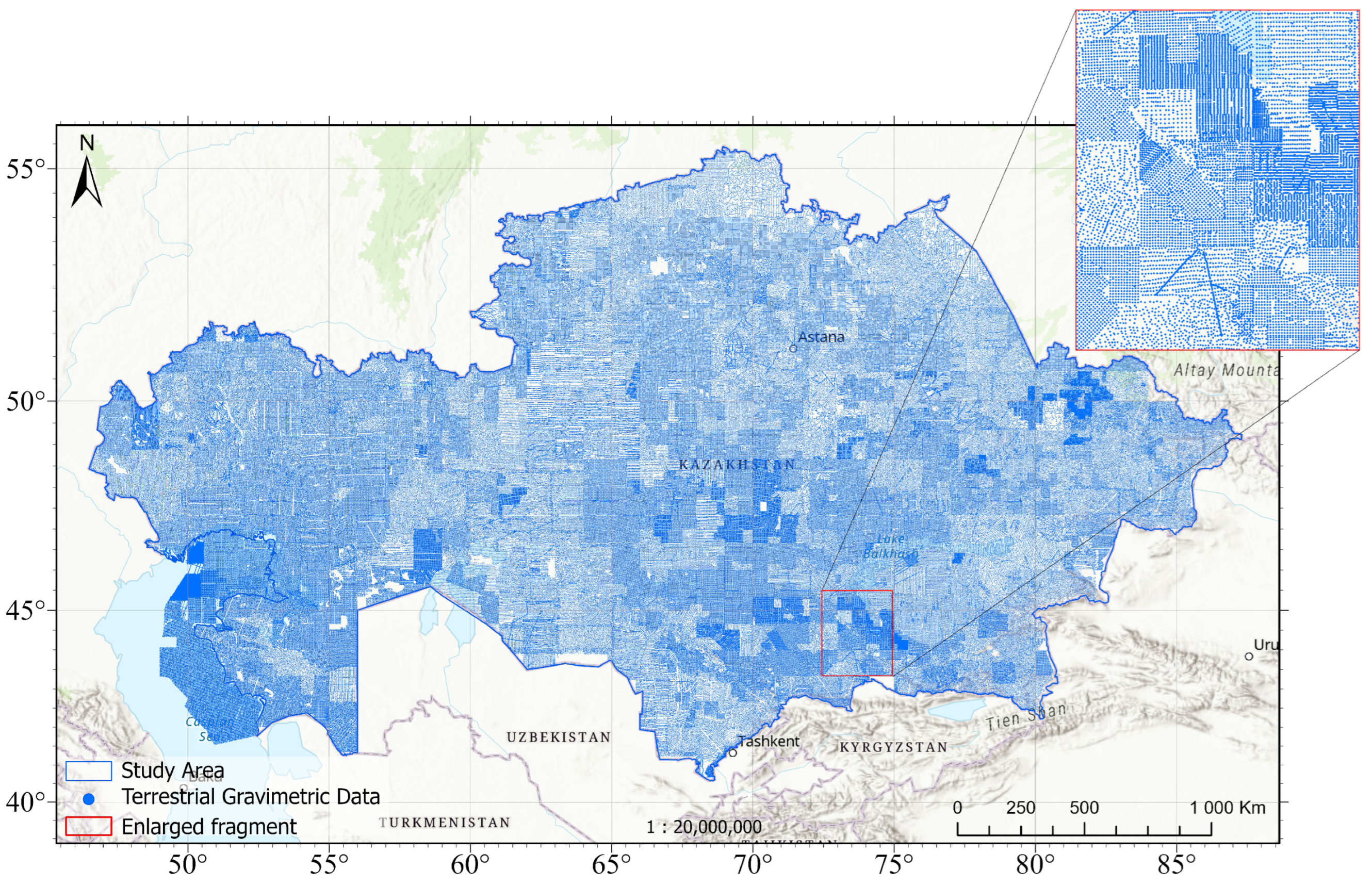
Within the territory of Kazakhstan, the compiled terrestrial gravimetric dataset comprises 651,862 points, corresponding to an average density of 0.24 points/km2 (approximately one point per 4.2 km2). The distribution of the digitized gravity-anomaly values across the gravimetric maps is shown in Figure 2.

3.2. Global Geopotential Models

Three global geopotential models were used for validation and comparison: EGM2008, EIGEN-6C4, and XGM2019e_2159. This choice is justified by our previous evaluation of five GGMs (XGM2019e_2159, EIGEN-6C4, EGM2008, GECO, SGG-UGM-2) on a test site in the Turkestan region. The assessment used 112 points of the state geodetic network and independent GNSS/leveling data. XGM2019e_2159 and EIGEN-6C4 produced the smallest residuals: the standard deviation of height anomalies was 0.265 m and 0.266 m , respectively [23]. Therefore, these models are preferable for local geoid modeling in Kazakhstan. EGM2008 is included as a practical reference. In the absence of an approved regional geoid for Kazakhstan, it remains the de facto working model for height transformations and ensures backward compatibility with established surveying practice.
The EGM2008 (Earth Gravitational Model 2008), developed by the U.S. National Geospatial-Intelligence Agency (NGA) together with the U.S. Army Research Laboratory, is provided as a spherical-harmonic expansion complete to degree and order n = m = 2159 , with additional coefficients extending to degree 2190 and order 2159 [24]. For the territory of Kazakhstan, the 5 × 5 mean gravity anomalies were formed using a spectral “cut-and-paste” approach: for degrees l 720 proprietary 5 × 5 mean anomalies were used, while components 721 l 2159 were reconstructed from residual terrain model (RTM) effects. The Caspian Sea area is represented by SIO/NOAA satellite altimetry (the Sandwell–Smith grids); where appropriate, a linear combination with DNSC07 is applied. The long-wavelength part of the combined solution is constrained by GRACE data. Given this source composition, one should expect increased uncertainty in EGM2008-derived fields in the mountainous southeast and more stable estimates over plains and marine areas [24,25].
The EIGEN-6C4 (European Improved Gravity model of the Earth by New techniques, Release 6C4), developed by GFZ Potsdam in cooperation with GRGS Toulouse, represents the latest release of the combined EIGEN-6C model series [26]. The model is provided as a spherical-harmonic expansion complete to degree and order n = m = 2190 (corresponding to a spatial resolution of about 9–10 km). Its construction is based on the combination of the following: (i) LAGEOS satellite laser ranging data (1985–2010), used up to degree/order 30; (ii) GRACE mission data (2003–2012, Release 03), represented as normal equations up to degree 175; (iii) GOCE SGG observations (components Txx, Tyy, Tzz, Txz), processed with band-pass filtering and weighting functions up to degree 300; and (iv) the global DTU10 gravity anomaly grid ( 2 × 2 ), including satellite altimetry over the oceans and EGM2008 over the continents, used to reconstruct the spectrum up to degree 2190. The final solution was obtained by a band-limited combination of normal equations. Comparative evaluations demonstrated improved consistency with GOCE and CHAMP orbit data, as well as reduced discrepancies with GPS/leveling results (e.g., RMS in Brazil decreased from 36.6 cm for EGM2008 to 30.6 cm for EIGEN-6C4). At long wavelengths, the model is consistent with GRACE-based solutions, while at short wavelengths it reproduces the structure of EGM2008 with enhanced coherence due to the inclusion of GOCE data.
The XGM2019e_2159 model, developed by the Institute of Astronomical and Physical Geodesy at the Technical University of Munich [27], is delivered as spherical harmonics truncated to n = 2190 , m = 2159 (ICGEM also provides realizations truncated at 760 and 5540). The construction of the model relies on three complementary sources: (i) the satellite component GOCO06s, used as an unconstrained normal-equation system (effective for long wavelengths, roughly up to l 300 ); (ii) a global 15 grid of mean gravity anomalies from NGA, pre-band-limited to l = 719 and reduced to the spheroid surface; and (iii) a “ 1 ” set comprising forward-modeled, topography-derived anomalies over land (EARTH2014) and altimetric anomalies over the oceans (DTU13). In terms of quality, XGM2019e clearly outperforms EGM2008 over the oceans (MDT vs. DTU17MDT: ∼2.0 cm versus 3.3 cm), yields a moderate gain on land at medium degrees with more homogeneous global behavior, while at very high degrees it may locally be inferior to solutions augmented with dense terrestrial data.

3.3. Modern Gravimetric Reference Frame (QazGRF)

Kazakhstan’s modern gravimetric reference frame is realized by a set of stations at which absolute gravity measurements were conducted in 2023–2024 by the National Center for Geodesy and Spatial Information (see Figure 3) [28,29,30].
QazGRF was formed from both existing stations of the USSR first-order gravity network and newly established stations. From the Soviet network, Kazakhstan inherited 96 stations; however, after an inspection in 2021, the actual number amounted to only 42 stations, i.e., 40%. Therefore, to implement the new system, new stations were established in addition to the existing ones.
The new gravimetric reference for the Republic of Kazakhstan is organized as a set of 76 absolute gravity stations and 142 additional relative gravity stations, distributed within distances up to 50 km from the absolute ones, serving the purposes of redundancy, rapid access, and investigation of gravity variations.
The 50 km criterion refers specifically to the additional relative stations established in the vicinity of the absolute ones, rather than to the general spacing between all stations of the network. Exceptions to the 50 km buffer include several historical sites and a station in Almaty, where the radius was increased to 150 km due to increased seismicity.
In several sparsely populated regions, such as west of Lake Balkhash and other remote areas with a desert-like climate and limited infrastructure, larger gaps are present. These reflect logistical constraints rather than deficiencies in the design of the gravimetric reference network.
The work utilized a Micro-g LaCoste A10 absolute gravimeter as well as Scintrex CG-6 Autograv relative gravimeters. The total expanded uncertainties of the measured gravity values at all 218 stations do not exceed 10 µGal. These data were used to validate and calibrate the Soviet-era gravity measurements.

4. Methods

4.1. Corrections to Gravimetric Surveys

In historical gravimetric surveys, systematic errors are inevitably present due to the use of different initial parameters and assumptions. In different periods, various formulas of normal gravity were applied, based on differing values of reference ellipsoid parameters; different gravimetric systems with their inherent corrections were adopted; and diverse methods and instruments were employed for gravity measurements. All these factors result in gravity anomalies from Soviet-era gravimetric surveys being not directly comparable with modern observations and global models. Therefore, before these data can be reliably used, it is necessary to introduce a system of corrections that brings the archival values into the current reference system and ensures their compatibility with contemporary sources of information.
The computation of the gravity anomaly is based on a model of the normal gravity field defined on a reference ellipsoid. Normal gravity values are obtained by differentiating the expression for the normal potential with respect to the normal to the level (equipotential) surface [31,32]:
γ ( B ) = γ e 1 + 5 2 q f 17 14 f q sin 2 B 5 8 f q f 2 8 sin 2 2 B ,
where B is the geodetic latitude, γ e is the normal gravity at the equator, and q and f are ellipsoid parameters related to the flattening.
Since 1884, the coefficients of Formula (1) have been revised multiple times as new data have accumulated (more than 10 different formulas are known) [33]. One of the first such formulas was Friedrich Rudolf Helmert’s formula, proposed in 1901–1909 [34]:
γ 0 Helm = 978,030 1 + 0.005302 sin 2 B 0.0000072 sin 2 2 B mGal .
which was widely applied in computing gravity anomalies for archival gravimetric maps, because the ellipsoid parameters used in Formula (2) are close to those of the Krassowsky ellipsoid, which was adopted in the Soviet Union as the basis of the coordinate system.
By the late 1960s, a substantial portion of Soviet surveys had been carried out in the Potsdam system, which is known to have been lower by approximately 13.8–14 mGal [33]. In addition, with the adoption of new normal-Earth parameters in 1967 and later in 1980, the formulas for computing normal gravity were updated [35]:
γ 0 GRS 80 = 978,032.7 1 + 0.0053024 sin 2 B 0.0000058 sin 2 2 B mGal .
The differences between (3) and (2) proved to be minor, so recomputation of previously compiled maps was not required [36] (unlike in other countries where the 1930 Cassini formula was used; in those cases, adjustments were required not only due to differences in g e but also due to different values of the flattening f). To reconcile new surveys conducted after the introduction of the 1971 gravimetric system with previously compiled maps, 14 mGal was subtracted from the normal gravity (2) [37,38]. Thus, gravity anomalies in Soviet surveys were calculated using the normal Helmert Formula (2), but with a subtraction of 14 mGal, and the correction for transitioning to GRS80 [35] for Soviet gravimetric maps is given by
δ γ GRS 80 = γ 0 GRS 80 γ 0 Helm 14 = 16.70 0.405 sin 2 B 1.37 sin 2 2 B mGal ,
whose values over Kazakhstan range from —18.04 to —17.03 mGal.
Since, in digitizing the gravimetric maps, the station coordinates were transformed from the Pulkovo 1942 coordinate system on the Krassowsky ellipsoid to the WGS84 geodetic system, the gravity anomalies were also adjusted for using, in Formula (2), the Krassowsky latitude instead of the GRS80 latitude. This correction is obtained from the derivative of Formula (2) with respect to latitude, applied to the difference Δ B . The corresponding expression is given by
δ γ Lat = 978,030 0.005302 sin 2 B 0.000014 sin 4 B Δ B ,
where Δ B = B GRS 80 B Krass is the difference between GRS80/WGS84 and Krassowsky latitudes (in this case, the difference in latitudes at GRS80 and WGS84 is insignificant). For Kazakhstan, it ranges from 0.01 to 0.06 mGal.
Moreover, all surveys were carried out from first-order gravimetric network stations in the IGSN71. In this system, the observed gravity values were reduced by applying the permanent tide correction, known as the Honkasalo correction [39,40], which is no longer applied in modern gravity measurement practice:
δ g Honk = k ( 1 3 sin 2 φ ) ,
where k = 0.037 , φ is the geocentric latitude of the station.
Later, the coefficient k was refined (for example, k = 0.0350 in [41]), while in Soviet and Russian practice [42,43] an equivalent formulation was adopted, where the coefficient k was expressed through the delta factor ρ :
δ g Honk = 0.03057 ρ ( 1 3 sin 2 φ ) ,
where ρ is the Earth-elasticity influence coefficient, i.e., the ratio of the observed amplitude of the tidal effect to the theoretical one computed for a “rigid” Earth. In this study, the coefficient was taken as ρ = 1.16 .
Thus, for the correction of the archival gravity survey data of the Soviet Union, we used this latter Formula (7), ensuring consistency with the modern practice. Across Kazakhstan, the correction ranges from 0.008 to 0.036 mGal.
Finally, as a result of establishing QazGRF, the system offset of the first-order gravimetric network relative to modern absolute gravity measurements was determined, amounting to approximately δ g syst = g 2024 g 198 x 0.07 mGal. This estimate was obtained by analyzing repeat gravity measurements at the 27 surviving first-order network stations.
Thus, to make the Soviet-era Bouguer anomalies consistent with the gravimetric system currently in use, all of the above corrections must be applied:
Δ g Bouguer = Δ g Bouguer map + δ γ GRS 80 + δ γ Lat + δ g Honk + δ g syst ,
where Δ g Bouguer map is the Bouguer anomaly as originally reported in the Soviet gravimetric surveys.

4.2. Accuracy Assessment Against Global Gravity Models

To assess the reliability and consistency of the Soviet-era gravimetric data with modern gravity field standards, their evaluation was performed using the GGMs. The gravity anomaly Δ g GGM at a point P ( φ , λ , r ) on the Earth’s physical surface was calculated from the respective model as follows: [31,32]:
Δ g GGM = G M r 2 n = 2 ( n 1 ) a r n m = 0 n Δ C ¯ n m cos m λ + S ¯ n m sin m λ P ¯ n m ( sin φ ) ,
where G M is product of gravitational constant and mass of the Earth, r is the distance to the geocenter, a is the reference radius, Δ C ¯ n m = C ¯ n m C ¯ n m 0 , S ¯ n m are the spherical harmonic coefficients of the disturbing potential, P ¯ n m ( sin φ ) are the fully normalized associated Legendre functions, and φ , λ are the spherical latitude and longitude, respectively.
The discrepancy between the model data and the gravity anomalies from the Soviet-era gravimetric maps is expressed as the difference:
δ Δ g = Δ g map Δ g GGM ,
where Δ g map are the gravity-anomaly values at the point with geodetic coordinates B and L taken from the gravimetric maps, and Δ g GGM are the gravity-anomaly values computed from the coefficients of the global model using Formula (9).

4.3. Assessment Based on Gravity Measurements

The highest-quality assessment of the accuracy of historical gravimetric maps can be obtained by comparison with modern gravity measurements. To this end, using the constructed regular grid of Bouguer anomalies Δ g Bouguer , we interpolated anomaly values for all 218 QazGRF stations. After applying the required corrections (see Section 4.1) to Δ g B , we reconstructed the absolute gravity values g using the inverse of the formula for calculating the Bouguer anomaly that was used in compiling the gravity maps [37]:
g = Δ g Bouguer + γ 0 + ( 0.3086 0.0419 σ ) H γ ,
where γ 0 is the normal gravity in the GRS80 system, σ is the density of the simple slab ( σ = 2.67 g / cm 2 ), and H γ is the normal height in the Baltic System of 1977.
Subsequently, for all stations, the differences between the reconstructed (map-derived) and measured absolute gravity values were computed:
δ g meas = g map g meas ,
where g map is the reconstructed absolute gravity values from (11), and g meas is the measured absolute gravity values.

5. Results

The quality of the Soviet-era gravimetric surveys was assessed through comparison with the global geopotential models EGM2008, EIGEN- 6c4 and XGM2019e_2159, according to Equation (10).
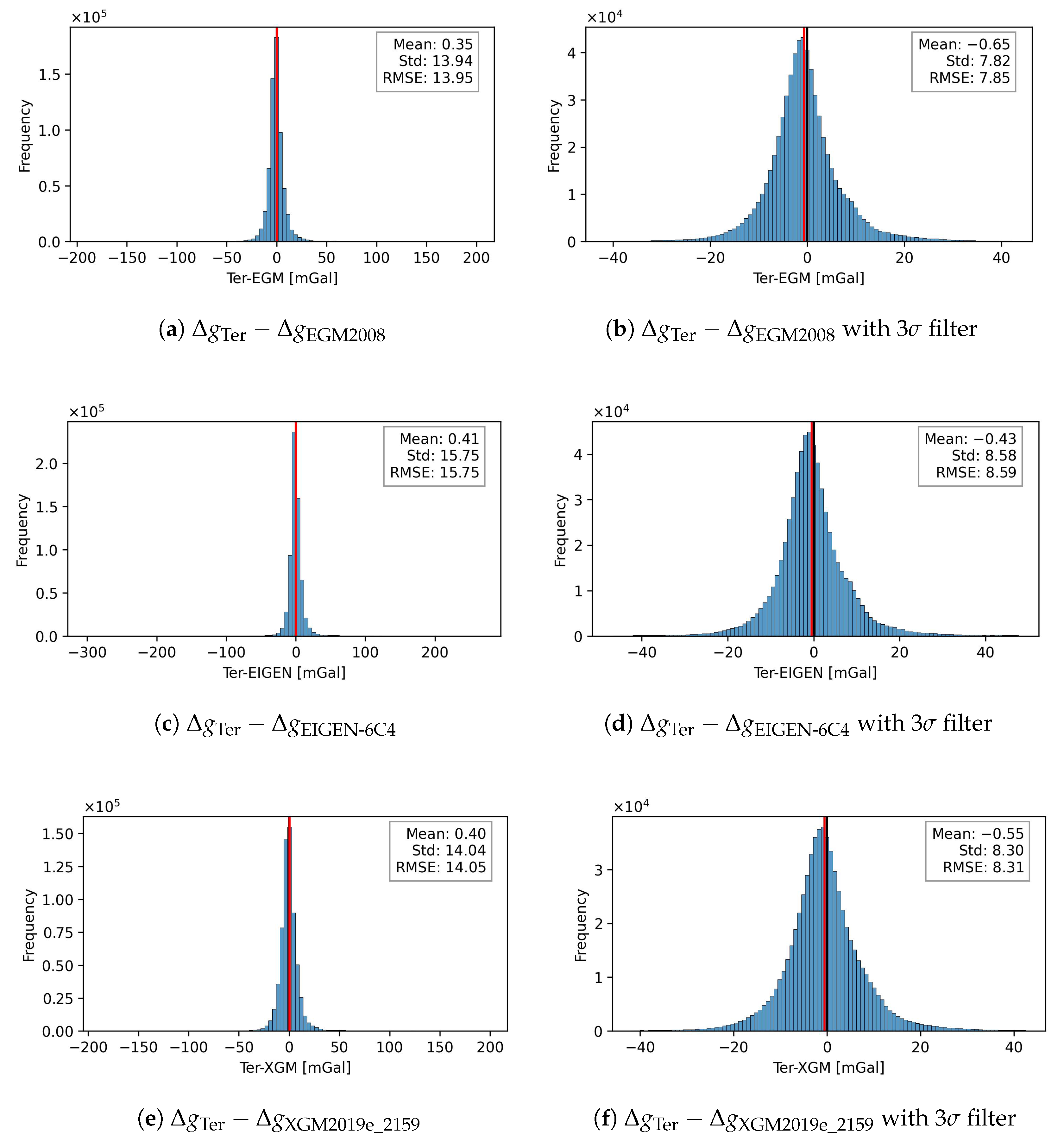
The summary metrics for the whole territory of Kazakhstan from Table 1 at N = 651,862 show that for δ Δ g Ter EGM 2008 and δ Δ g Ter XGM2019e _ 2159 we obtained similar aggregate estimates with negative medians, indicating mild right-skewness due to rare positive extremes.
The histograms in Figure 4a,c,e show a normal distribution of deviations for all the models used.
Outlier rejection was carried out using a 3σ filter, which excluded a small fraction of anomalous measurements from the dataset. This filtering step noticeably improved the internal consistency of the data, resulting in lower standard deviations and RMSE values for both global models, while also constraining the range of extreme deviations. The corresponding distribution histograms (Figure 4b,d,f) indicate that, after filtering, the gravity anomaly differences closely follow a near-normal distribution. A minor shift in the mean values was observed; however, its magnitude is negligible compared to the overall data dispersion and does not influence the final conclusions.
A spatial analysis of the difference maps after 3σ filtering in Figure 5 reveals that over the northern and central plains, the values generally remain within ±20 mGal, with the Δ g Ter–XGM2019e_2159 field appearing smoother compared to EGM2008. In the Caspian Lowland and Ustyurt–Mangyshlak areas, a systematic positive bias up to +40–50 mGal is observed. In the mountainous regions (Tian Shan, Dzungarian Alatau, Altai), alternating anomalies in the range of —40 to +40 mGal are evident, reflecting the insufficient recovery of short-wavelength components in both global models. The inter-model differences (EGM2008–XGM2019e_2159) are generally confined to ±20 mGal, with local contrasts reaching ±30 mGal along the Caspian coast and in the southeastern mountains.
Of particular interest is an artifact on sheet M43: its presence is confirmed both by comparison with terrestrial data and by the inter-model differences (EGM2008– XGM2019e_2159), which indicates that it originates from errors in the global models. It is most likely related to inaccuracies in EGM2008 that were subsequently inherited by later solutions (e.g., EIGEN-6C4), which relied on the high-degree coefficients of EGM2008. In contrast, XGM2019e employs a revised combination strategy: for degrees higher than 719, land gravity anomalies are represented exclusively by forward modeled topographic anomalies (EARTH2014). This explains why the M43 artifact is less pronounced in the differences with XGM2019e compared to EGM2008 and EIGEN-6C4, and why it appears in the EGM2008–XGM2019e difference map but not in the EGM2008–EIGEN-6C4 difference.
Pavlis et al. [24] also noted systematic biases of about 6–8 mGal in this broader region, which is consistent with the presence of increased uncertainties, although not specifically attributed to the M43 cell. Overall, the inter-model difference map Δ g EGM 2008 Δ g XGM2019e_2159 is generally characterized by values within ± 5 15 mGal, with local contrasts up to 25–35 mGal along the Caspian coast and in the southeastern mountains. These differences can be attributed to the distinct fill-in datasets (5′ mean anomalies for EGM2008 versus 15′ for XGM2019e_2159) and to variations in the combination and regularization schemes for satellite and terrestrial data.
For the assessment with QazGRF measurements, gravity anomalies were interpolated to the control points. To quantify the interpolation error, leave-one-out cross-validation was applied, yielding a mean error of –0.02 mGal and an RMS of 3.8 mGal. The results of the quantitative assessment based on the differences between the reconstructed and measured gravity values, δ g meas by Equation (11), at 218 QazGRF stations are summarized in Table 2, which presents the statistical evaluation of gravity anomalies subdivided by terrain type.
The mean of the differences is 0.7 mGal, indicating no significant systematic bias within the accuracy of the gravimetric maps. The distribution of δ g meas (Figure 6) is close to normal, with most values falling within ± 5 mGal.
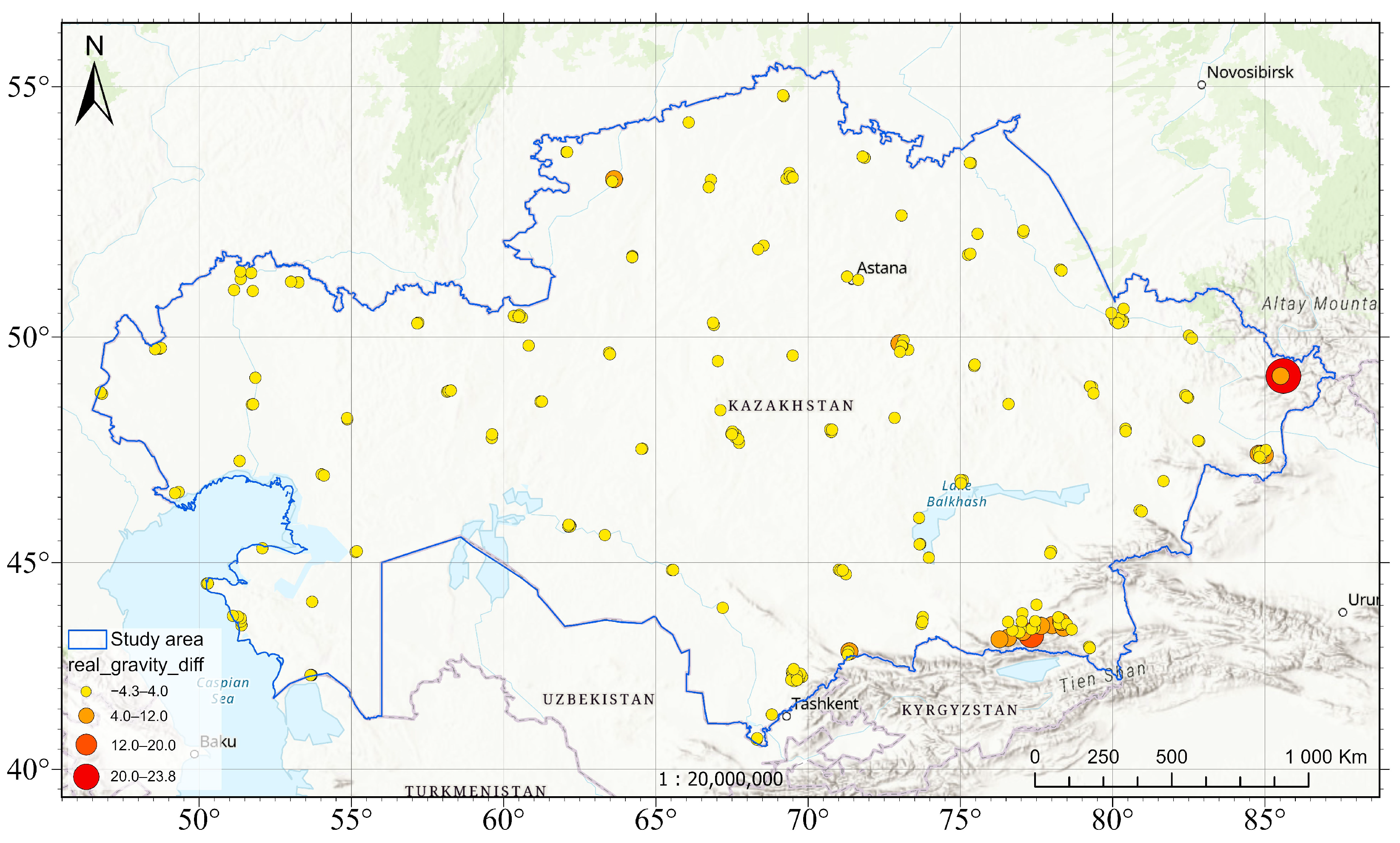
The spatial structure of the discrepancies at the QazGRF stations is shown in Figure 7, which makes it possible to identify local zones with the largest deviations and to assess the regional consistency of the historical data with the global models.
As can be seen from Figure 7 and Table 2, the largest deviations are likewise associated with the mountainous regions of the Tian Shan and the Zhetysu Alatau, where their magnitudes exceed 5 mGal. For a more informative assessment, it is advisable to use modern gravimetric surveys in mountainous regions referenced to QazGRF.

6. Conclusions

The analysis showed that the Soviet-era 1:200,000 gravimetric maps, after applying the necessary systematic and methodological corrections, generally retain high informational content for a substantial part of Kazakhstan. The mean discrepancy with modern measurements at the QazGRF stations is 0.7 mGal, and the standard deviation is 2.5 mGal. More than 90% of the points have deviations within ± 5 mGal. According to the results of Joseph Olayemi [44], with a 3 × 3 grid and gravimetric data accuracy of about 5 mGal, the achievable geoid accuracy is approximately 6 cm, which confirms the feasibility of using Soviet-era data for geoid modeling. Zones with large discrepancies (up to ± 20 mGal) were identified, primarily associated with the mountainous regions of the Tian Shan and the Zhetysu Alatau.
The key finding of this study is the identification of a distinct artifact on the EGM2008 M-43 map sheet, revealed by the comparison between terrestial gravity anomalies. The artifact has a distinct rectangular shape along the map boundaries, and its geometric regularity indicates systematic errors in the Earth’s surface “filling” data, subsequently inherited by later global gravity field solutions. This finding highlights the need for rigorous validation of global models before their use in determining the regional geoid and related geodetic applications.
The comparison with the XGM2019e_2159 model showed that the main patterns in the distribution of discrepancies persist, which confirms the robustness of the identified features and the need to account for them when integrating archival data into modern models.
Based on the conducted study, the following is recommended:
Use Soviet gravimetric measurements in plains and foothill regions with verification against modern measurements;
Carry out priority gravimetric surveys in zones with | δ g | > 5 mGal, especially in mountainous areas and at locations of identified artifacts;
Integrate the updated data into the refinement of the national geoid model and the vertical geodetic framework.
Thus, provided that they are critically re-evaluated and correctly transformed into the modern reference system, Soviet gravimetric data can serve as a reliable source of information for constructing high-accuracy regional models of the gravity field and the geoid in Kazakhstan.

Author Contributions

Conceptualization, D.S. and A.U.; methodology, D.S., A.U. and R.S.; software, D.S. and R.S.; validation, D.S., A.U., M.K. and N.Z.; formal analysis, D.S., A.U. and R.S.; investigation, D.S., A.U. and R.S.; resources, A.U., A.I. and R.S.; data curation, A.U., S.N. and N.Z.; writing—original draft preparation, D.S., A.U. and R.S.; writing—review and editing, D.S., R.S. and N.Z.; visualization, M.K. and N.Z.; supervision, D.S. and A.U.; project administration, S.N.; funding acquisition, S.N. All authors have read and agreed to the published version of the manuscript.

Funding

This research was funded by the Committee of Science of the Ministry of Science and Higher Education of the Republic of Kazakhstan (Grant No. BR21882366).

Data Availability Statement

The data presented in this study are available on request from the corresponding author.

Conflicts of Interest

Author Daniya Shoganbekova and Nailya Zhaksygul are employed by International Education Corporation. The remaining authors declare no conflicts of interest.

References

  1. Torge, W.; Müller, J.; Pail, R. Geodesy; De Gruyter: Berlin, Germany, 2023. [Google Scholar] [CrossRef]
  2. Sideris, M.G. Geoid Determination, Theory and Principles. In Encyclopedia of Solid Earth Geophysics; Gupta, H.K., Ed.; Springer International Publishing: Cham, Switzerland, 2021; pp. 476–482. [Google Scholar] [CrossRef]
  3. Sermiagin, R.; Kemerbaev, N.; Kassymkanova, K.K.; Kalen, E.; Mussina, G.; Shkiyeva, M.K.; Samarkhanov, K.; Batalova, A.; Rakhimzhanov, A.; Zhumakanov, A.; et al. A historical overview of gravimetric surveys in Kazakhstan. Geod. Cartogr. 2024, 85, 53–64. (In Russian) [Google Scholar] [CrossRef]
  4. Makedonskii, E.L.; Balmino, G.; Galazin, V.F.; Kogan, M.G.; McNutt, M.K.; Fairhead, J.D. Gravity Field over the Former Soviet Union Mapped. Eos Trans. Am. Geophys. Union 1994, 75, 463–464. [Google Scholar] [CrossRef]
  5. Gerlach, C.; Ophaug, V.; Omang, O.C.D.; Idžanović, M. Quality and Distribution of Terrestrial Gravity Data for Precise Regional Geoid Modeling: A Generalized Setup. In IX Hotine-Marussi Symposium on Mathematical Geodesy; Novák, P., Crespi, M., Sneeuw, N., Sansò, F., Eds.; Springer International Publishing: Cham, Switzerland, 2019; Volume 151, pp. 209–215. [Google Scholar] [CrossRef]
  6. Oja, T.; Ellmann, A.; Märdla, S. Gravity Anomaly Field over Estonia. Est. J. Earth Sci. 2019, 68, 55. [Google Scholar] [CrossRef]
  7. Catalão, J.; Bos, M. Sensitivity Analysis of the Gravity Geoid Estimation: A Case Study on the Azores Plateau. Phys. Earth Planet. Inter. 2008, 168, 113–124. [Google Scholar] [CrossRef]
  8. Jekeli, C.; Yang, H.J.; Kwon, J.H. Using Gravity and Topography-Implied Anomalies to Assess Data Requirements for Precise Geoid Computation. J. Geod. 2009, 83, 1193–1202. [Google Scholar] [CrossRef]
  9. Jiang, T.; Dang, Y.; Zhang, C. Gravimetric Geoid Modeling from the Combination of Satellite Gravity Model, Terrestrial and Airborne Gravity Data: A Case Study in the Mountainous Area, Colorado. Earth Planets Space 2020, 72, 189. [Google Scholar] [CrossRef]
  10. Vergos, G.; Tziavos, I.; Andritsanos, V. Gravity Data Base Generation and Geoid Model Estimation Using Heterogeneous Data. In Gravity, Geoid and Space Missions; Jekeli, C., Bastos, L., Fernandes, J., Eds.; Springer: Berlin/Heidelberg, Germany, 2005; Volume 129, pp. 155–160. [Google Scholar] [CrossRef]
  11. Ellmann, A.; All, T.; Oja, T. Towards Unification of Terrestrial Gravity Data Sets in Estonia. Est. J. Earth Sci. 2009, 58, 229. [Google Scholar] [CrossRef]
  12. Lücke, O.H.; Vega Fernández, A.; Varela Sánchez, M.; Barboza, L.A.; Garbanzo-León, J. The Improvements of the Costa Rican Ground-Based Gravity Dataset as a Result of a Comprehensive Attribute and Spatial Assessment of the Historical Databases. Appl. Geomat. 2021, 13, 401–413. [Google Scholar] [CrossRef]
  13. Vergos, G.S.; Natsiopoulos, D.A.; Mamagiannou, E.G.; Tzanou, E.A.; Triantafyllou, A.I.; Tziavos, I.N.; Ramnalis, D.; Polychronos, V. A Regional Gravimetric and Hybrid Geoid Model in Northern Greece from Dedicated Gravity Campaigns. Remote Sens. 2025, 17, 197. [Google Scholar] [CrossRef]
  14. Featherstone, W.E.; Alexander, K.; Sideriss, M.G. Gravimetric Geoid Refinement Using High Resolution Gravity and Terrain Data. Geomat. Res. Australas. 1996, 61, 75–99. [Google Scholar]
  15. Farahani, H.H.; Klees, R.; Slobbe, C. Data Requirements for a 5-Mm Quasi-Geoid in the Netherlands. Stud. Geophys. Geod. 2017, 61, 675–702. [Google Scholar] [CrossRef]
  16. Jekeli, C. Omission Error, Data Requirements, and the Fractal Dimension of the Geoid. In VII Hotine-Marussi Symposium on Mathematical Geodesy; Sneeuw, N., Novák, P., Crespi, M., Sansò, F., Eds.; Springer: Berlin/Heidelberg, Germany, 2012; Volume 137, pp. 181–187. [Google Scholar] [CrossRef]
  17. Makarenko, N.L.; Gusev, N.A.; Lokhov, V.V. About the state gravimetric network of the USSR. Geod. Cartogr. 1990, 1–5. (In Russian) [Google Scholar]
  18. Gusev, N.A.; Scheglov, N.S. Reference gravity networks. In Gravimetry and Geodesy; Nauchniy Mir: Moscow, Russia, 2010; pp. 319–332. (In Russian) [Google Scholar]
  19. Gusev, N.A. Agat Pendulum System. In The Interdepartmental Geophysical Committee Under the Presidium of the Academy of Sciences of the USSR; Results of High-Precision Gravimetric Measurements; Soviet Radio: Moscow, Russia, 1977; pp. 57–71, (In Russian). [Google Scholar] [CrossRef]
  20. Demyanov, G.; Sermyagin, R.; Basmanov, A.; Oshchepkov, I.; Popadyov, V.; Pozdnyakov, A. Development of the State Gravity Network in Russia. In Proceedings of the 4th IAG Symposium on Terrestrial Gravimetry: Static and Mobile Measurements (TG-SMM 2013), Saint Petersburg, Russia, 17–20 September 2013; pp. 152–157. [Google Scholar]
  21. Evdokimov, Y.S.; Zemlemerov, B.M.; Vorob’ev, L.S. GOST 13017-83; Surface Gravimeters. General Specifications. Standards Publishing House: Moscow, Russia, 1985. (In Russian)
  22. Boikov, V.; Galazin, V.; Kaplan, B.; Maksimov, V.; Bazlov, Y.A. Experience in creating the geocentric coordinate system PZ-90. Geod. Cartogr. 1993, 54, 17–21. (In Russian). Available online: https://geocartography.ru/en/scientific_article/1993_11_17-21 (accessed on 14 October 2025).
  23. Shoganbekova, D.; Urazaliyev, A.; Kassymkanova, K.; Kozhakhmetov, M. Evaluation of the Effectiveness of Global Geopotential Models for the Turkestan Region. Bull. Almaty Univ. Power Eng. Telecommun. 2024, 2, 96–105. (In Russian) [Google Scholar] [CrossRef]
  24. Pavlis, N.K.; Holmes, S.A.; Kenyon, S.C.; Factor, J.K. The Development and Evaluation of the Earth Gravitational Model 2008 (EGM2008). J. Geophys. Res. Solid Earth 2012, 117, B04406. [Google Scholar] [CrossRef]
  25. Klokočník, J.; Kostelecký, J.; Kalvoda, J.; Eppelbaum, L.; Bezek, A. Gravity disturbances, marussi tensor, invariants and other functions of the geopotential represented by EGM 2008. Earth Sci. Res. 2014, 2, 88–101. [Google Scholar] [CrossRef]
  26. Förste, C.; Bruinsma, S.; Abrikosov, O.; Lemoine, J.; Schaller, T.; Götze, H.; Ebbing, J.; Marty, J.; Flechtner, F.; Balmino, G.; et al. EIGEN6C4–The Latest Combined Global Gravity Field Model Including GOCE Data up to Degree and Order. 2015. Available online: https://dataservices.gfz-potsdam.de/icgem/showshort.php?id=escidoc:1119897 (accessed on 14 October 2025).
  27. Zingerle, P.; Pail, R.; Gruber, T.; Oikonomidou, X. The Combined Global Gravity Field Model XGM2019e. J. Geod. 2020, 94, 66. [Google Scholar] [CrossRef]
  28. Tazhedinov, D.; Islyamova, A.; Merkulov, M. Technical Report on the Mathematical Processing (Adjustment) of the Stations of the State Fundamental Gravimetric Network. Project Code: K.04.00086; Technical Report; RSE National Centre of Geodesy and Spatial Information: Astana, Kazakhstan, 2024. (In Russian) [Google Scholar]
  29. Tazhedinov, D.; Islyamova, A.; Merkulov, M. Technical Report on the Results of the Mathematical Processing (Adjustment) of the Stations of the State First-Order Gravimetric Network. Project Code: K.04.00087; Technical Report; RSE National Centre of Geodesy and Spatial Information: Astana, Kazakhstan, 2024. (In Russian) [Google Scholar]
  30. Sermiagin, R. Dataset from Processing the 2023–2024 Campaigns to Establish Kazakhstan’s Gravity Reference Frame (QazGRF24). Zenodo 2025. [Google Scholar] [CrossRef]
  31. Pellinen, L. Higher Geodesy (Theoretical Geodesy); Nedra: Mosow, Russia, 1978. (In Russian) [Google Scholar]
  32. Hofmann-Wellenhof, B.; Moritz, H. Physical Geodesy, 2nd ed.; Springer: Vienna, Austria, 2006. [Google Scholar] [CrossRef]
  33. Caputo, M. Review of Formulas for the Space Normal Gravity Field Of The Earth. In Geophysical Monograph Series; Orlin, H., Ed.; American Geophysical Union: Washington, DC, USA, 2013; pp. 121–126. [Google Scholar] [CrossRef]
  34. Helmert, F. Der normale Theil der Schwerkraft im Meeresniveau. In Sitzungsberichte der Königlich Preussi schen Akademie der Wissenschaften zu Berlin; Reimer: Berlin, Germany, 1901; pp. 327–336. [Google Scholar]
  35. Moritz, H. Geodetic Reference System 1980. J. Geod. 2000, 74, 128–133. [Google Scholar] [CrossRef]
  36. Ladynin, A. Potential Geophysical Fields in Geological Problems; Textbook; Novosibirsk State University: Novosibirsk, Russia, 2008. (In Russian) [Google Scholar]
  37. Veselov, K.; Varlamov, A.; Kastalskiy, E.; Stepanov, P. (Eds.) Gravity Survey Manual; Number 5 in Unified Technical Requirements; Nedra: Moscow, Russia, 1980. (In Russian) [Google Scholar]
  38. Šlikas, D.; Paršeliūnas, E.; Birvydienė, R.; Obuchovski, R. The Countrywide Historical Gravity Dataset of Lithuanian Territory. Preprint 2025. [Google Scholar] [CrossRef]
  39. Honkasalo, T. On the Tidal Gravity Correction. Boll. Geofis. Teor. Appl. 1964, 4, 34–36. [Google Scholar]
  40. Morelli, C.; Gantar, C.; Mcconnell, R.K.; Szabo, B.; Uotila, U.A. The International Gravity Standardization Net 1971 (I.G.S.N.71); International Association of Geodesy: Paris, France, 1972. [Google Scholar]
  41. Šimon, Z. A Comment on Honkasalo’s Correction. Stud. Geophys. Geod. 1980, 24, 92–96. [Google Scholar] [CrossRef]
  42. Guidelines on the Development of the State Gravimetric Network of the USSR (Fundamental and First Order); GUGK: Moscow, Russia, 1988. (In Russian)
  43. Guidelines for the Development of the High-Precision State Gravimetric Network of Russia; TsNIIGAiK: Moscow, Russia, 2004; (In Russian). Available online: https://meganorm.ru/Data2/1/4293855/4293855517.pdf (accessed on 14 October 2025).
  44. Odumosu, J.O.; Nnam, V.C. Gravity data requirements for decimetre accuracy regional geoid using Stokes’ Remove Compute Restore technique in Nigeria. Contrib. Geophys. Geod. 2020, 50, 325–346. [Google Scholar] [CrossRef]
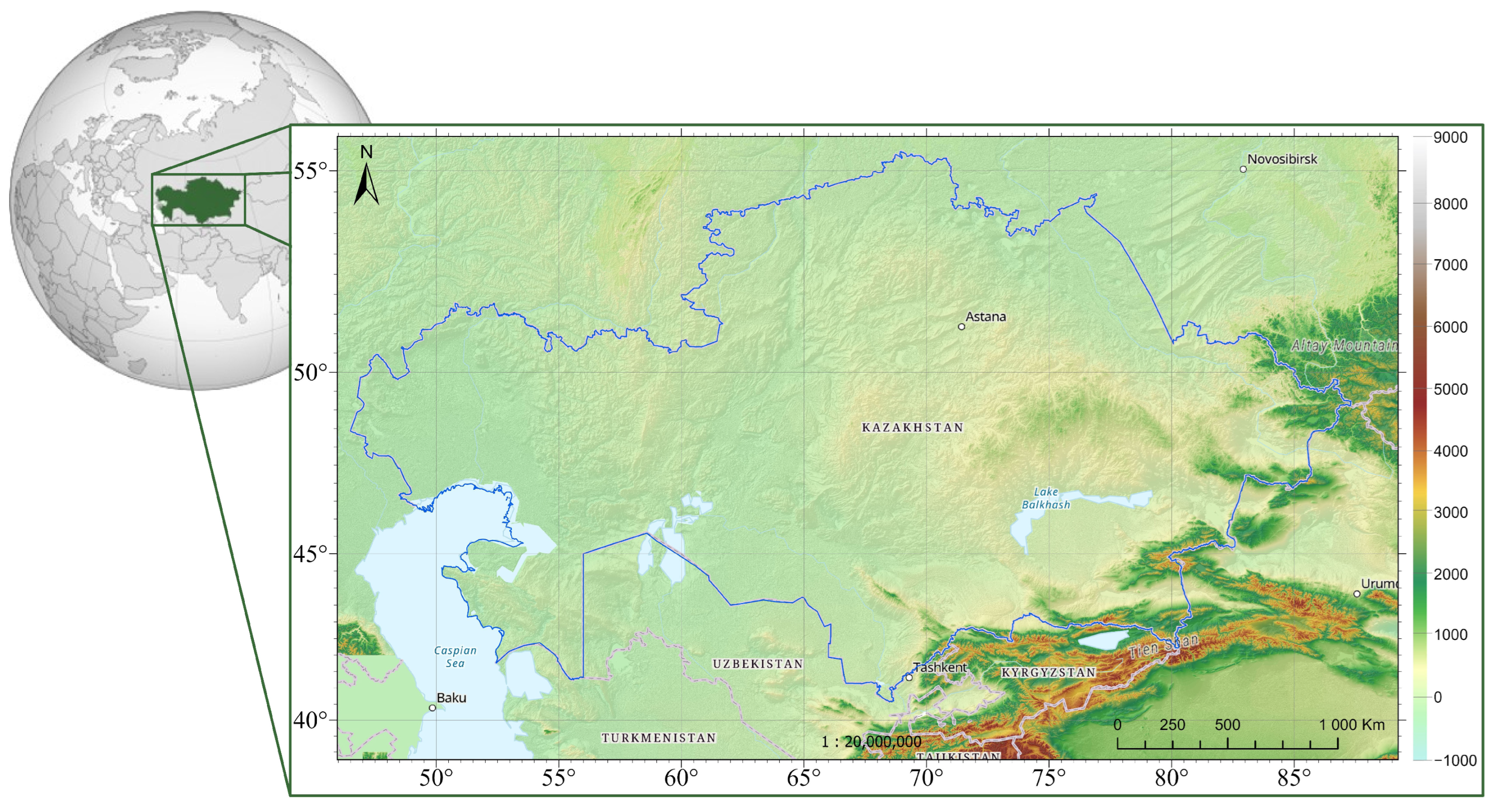
Figure 1. Location and topographic representation of the study area.
Geosciences 15 00404 g001
Figure 2. Spatial distribution and density of gravity observation points digitized from Soviet-era gravimetric maps.
Geosciences 15 00404 g002
Figure 3. QazGRF station network and buffer regions defining primary–secondary relations.
Geosciences 15 00404 g003
Figure 4. Histograms of the distributions of gravity differences between the Soviet-era gravimetric data and the global geopotential models before and after 3 σ filtering: (a) EGM2008; (b) EGM2008 with 3 σ filter; (c) EIGEN-6C4; (d) EIGEN-6C4 with 3 σ filter; (e) XGM2019e_2159; (f) XGM2019e_2159 with 3 σ filter.
Geosciences 15 00404 g004
Figure 5. Difference maps after outlier rejection, illustrating systematic biases and the M43 artifact: (a) δ Δ g Ter EGM 2008 ; (b) δ Δ g Ter–XGM2019e_2159; (c) δ Δ g Ter EIGEN- 6 C 4 ; (d) δ Δ g EGM2008–XGM2019e_2159.
Geosciences 15 00404 g005
Figure 6. Histogram of the distribution of differences between measured and interpolated gravity values at 218 QazGRF stations.
Geosciences 15 00404 g006
Figure 7. Map of the discrepancies between measured and interpolated gravity values at the QazGRF stations.
Geosciences 15 00404 g007
Table 1. Statistical assessment of differences between ground-based and global gravity data before and after 3 σ filtering.
PointsMeanStDMin25%50%75%MaxRMSE
CountmGalmGalmGalmGalmGalmGalmGalmGal
Before
Ter–EGM2008 651,862 0.35 13.94 187.44 4.55 0.97 2.98 198.52 13.95
Ter–EIGEN-6C4 651,862 0.41 15.75 299.74 4.67 0.85 3.55 266.36 15.75
Ter–XGM2019e_2159 651,862 0.40 14.04 185.62 4.89 0.84 3.68 197.94 14.05
EGM2008–XGM2019e_2159651,862 0.05 3.46 30.19 1.96 0.05 2.06 22.52 3.46
After 3 σ -filter
Ter–EGM2008 641,607 0.65 7.82 41.45 4.57 1.03 2.77 42.16 7.85
Ter–EIGEN-6C4 639,655 0.43 8.58 46.81 4.66 0.91 3.32 47.65 8.59
Ter–XGM2019e_2159 641,909 0.55 8.30 41.72 4.91 0.91 3.46 42.52 8.31
Table 2. Statistical evaluation of gravity anomalies ( δ g ) at 218 QazGRF stations by terrain type.
TerrainStationMeanStDMin25%50%75%MaxRMSE
Type Count mGal mGal mGal mGal mGal mGal mGal mGal
Flat1790.31.6−4.3−0.50.10.87.41.6
Hilly331.22.1−1.8−0.30.72.06.12.4
Mountainous68.68.91.01.95.612.523.811.8
Overall2180.72.5−4.3−0.50.21.123.82.6
Disclaimer/Publisher’s Note: The statements, opinions and data contained in all publications are solely those of the individual author(s) and contributor(s) and not of MDPI and/or the editor(s). MDPI and/or the editor(s) disclaim responsibility for any injury to people or property resulting from any ideas, methods, instructions or products referred to in the content.