Article

Preliminary Study on the Activity of the Rupture Zone in the Eastern Segment of the Ba Co Fault in Ngari Prefecture, Tibet

1
Lanzhou National Observatory of Geophysics, Lanzhou 730000, China
2
Lanzhou Institute of Seismology, China Earthquake Administration, Lanzhou 730000, China
3
School of Earth System Science, Institute of Surface-Earth System Science, Tianjin University, Tianjin 300072, China
*
Author to whom correspondence should be addressed.
Geosciences 2025, 15(10), 377; https://doi.org/10.3390/geosciences15100377
Submission received: 5 June 2025 / Revised: 30 August 2025 / Accepted: 1 September 2025 / Published: 1 October 2025

Abstract

The lack of research on the slip behavior of the NW-trending faults in the central Tibetan Plateau constrains our understanding of the deformation models for this region. The Ba Co Fault, located in the central Tibetan Plateau, is a NW–SE-trending right-lateral strike-slip fault. Its eastern section has been active in the Holocene and plays an important accommodating role in the northward compression and east–west extension of the Tibetan Plateau. This study presents a detailed analysis of the geomorphic features of the eastern section of the Ba Co Fault in the Ngari Prefecture of Tibet, precisely measuring the newly discovered surface rupture zone on its eastern side and preliminarily discussing the activity of the fault based on the optically stimulated luminescence (OSL) dating results. The results reveal that the eastern segment of the Ba Co Fault displays geomorphic evidence of offset, including displaced Holocene alluvial–fluvial fans at the mountain front and partially offset ridges. A series of pressure ridges, trenches, counter-slope scarps, and shutter ridge ponds have developed along the fault trace. Some gullies exhibit a cumulative dextral displacement of approximately 16–52 m. The newly discovered co-seismic surface rupture zone extends for a total length of ~21 km, with a width ranging from 30 to 102 m. Pressure ridges within the rupture zone reach heights of 0.3–5.5 m, while trenches exhibit depths of 0.6–15 m. Optically stimulated luminescence (OSL) dating constrains the timing of the surface-rupturing earthquake to after 5.73 ± 0.17 ka. The eastern segment of the Ba Co Fault experienced a NW-trending compressional deformation regime during the Holocene, manifesting as a transpressional dextral strike-slip fault. Magnitude estimation indicates that this segment possesses the potential to generate earthquakes of M ≥ 6. The regional tectonic analysis indicates that the activity of the eastern section of the Ba Co Fault is related to the shear model of the conjugate strike-slip fault zone in the central Tibetan Plateau and may play a boundary role between different shear zones.

1. Introduction

Since the Cenozoic, the collision between the Indian Plate and the Eurasian Plate has formed the Tibetan Plateau, the highest plateau in the world. Its uplift has reshaped the tectonic configuration of the entire Eurasian continent [1,2,3,4]. During the Cenozoic, continued convergence between the Indian and Eurasian plates formed the Himalayan-Tibetan orogenic belt—the world’s highest elevation and most intensely deformed active orogenic system [5,6,7]. A series of large-scale strike-slip faults developed within the plateau (Figure 1a) have played a significant role in restricting and transforming the tectonic framework of the Qinghai-Xizang Plateau and the evolution of collisional orogenic systems. Particularly, the collision between the Indian and Asian plates has led to a large amount of material on the southeastern margin of the Qinghai-Xizang Plateau escaping or extruding laterally in the southeast and south directions [1,8,9].
A series of conjugate strike-slip faults within the central Tibetan Plateau, linked to N-S trending rifts, are recognized as the youngest tectonic deformation features within the plateau interior. They have jointly absorbed and regulated the north–south compression and east–west extension effects in the central Qinghai-Xizang Plateau since the late Cenozoic, during which time a large nearly north–south-trending rift valley developed in southern Xizang (Figure 1a) [10,11,12,13,14,15]. On both the north and south sides of the Bangong Lake-Nujiang Suture Zone, there are northeast and northwest conjugate strike-slip faults, coexisting with north–south normal faults (Figure 1a) [16,17]. Taylor et al. [13] proposed that the deformation pattern of central Tibet is controlled by conjugate strike-slip fault systems. This system comprises two sets of strike-slip faults—NE-striking and NW-striking—which accommodate N-S crustal shortening and E-W extension in central Tibet through the eastward extrusion of small wedge-shaped blocks. These active faults are interpreted as absorbing the principal deformation strain between the Tibetan Plateau and its northern blocks [18] (Figure 1). In order to better clarify the relationship among these conjugate strike-slip faults, in recent years, researchers have conducted relevant studies on the characteristics of active faults within the Qiangtang block in the northern part of Ali. However, due to the harsh geographical conditions and inconvenient transportation in Ngari Prefecture, there are few studies on the activity characteristics of the Ba Co Fault (hereafter abbreviated as BCF) in the Ngari Prefecture (Figure 1b and Figure 2), and there is a lack of quantitative research.
Furthermore, the harsh high-altitude, cold environment and difficult transportation conditions have also resulted in relatively weak research on active faults in this area. During a field investigation for the Tibetan Scientific Expedition, our team discovered a segment of an earthquake rupture zone along the eastern section of the Ba Co Fault within Geji County, northern Ngari Prefecture, Tibet (Figure 3 and Figure 4). The BCF, together with NE-trending sinistral strike-slip faults (such as the Aweng Co Fault), constitutes boundary effects within pure shear or simple shear models [19,20] (Figure 2b). Its activity may influence stress accumulation and release on adjacent fault zones. Meanwhile, due to the lack of historical seismic records and seismic event data for this fault, the implementation of regional hazard assessment work in this area has been restricted. In recent years, although many seismic surface rupture zones have been identified within the interior of the Tibetan Plateau [20,21,22,23,24], research on seismic activity remains weak, resulting in a low level of regional seismic hazard assessment. Therefore, to determine the activity characteristics of this rupture segment, this study focuses on analyzing the kinematic properties of the eastern part of the fault using high-resolution topographic data and optically stimulated luminescence (OSL) dating. This will help fill the research gap concerning this fault segment and provide critical evidence for a deeper understanding of regional tectonic deformation and seismic hazard.

2. Background of the Study Area

The structural geometry and activity of the suture zones in the Tibetan Plateau constitute an integral component for understanding the tectonic evolution of the Tibetan Plateau. The interior of the Qinghai-Xizang Plateau is composed of different plots, and different suture zones are formed between these plots (Figure 1a). The southern Tibetan tectonic units primarily include the Himalayan terrane and the Indus-Yarlung Tsangpo Suture (IYTS) flanking the Lhasa terrane (Figure 1a), as well as the Bangong-Nujiang Suture (BNS) bounding the Lhasa and Qiangtang terranes [10,25]. The Bangong-Nujiang Suture represents a major tectonic belt formed by the collision and amalgamation of the Lhasa and Qiangtang terranes [5,10,20,23]. East–west extension structures have been widely developed in the Lhasa block and the Qiangtang block, manifested as a series of near-north–south rifts and conjugate strike-slip faults. These conjugate strike-slip faults are mainly distributed on both the north and south sides of the Bangong Lake-Nujiang joint zone (Figure 1a). The north side is mainly composed of left-rotating strike-slip faults running northeast, and the south side is mainly composed of right-rotating strike-slip faults running northwest (Figure 1a). The near-north–south rift almost traverses all of the east–west trending tectonic units, passing northward through the Lhasa Block and the Qiangtang Block, and connecting with the right-handed strike-slip faults on the south and northwest sides [11,13,25,26].
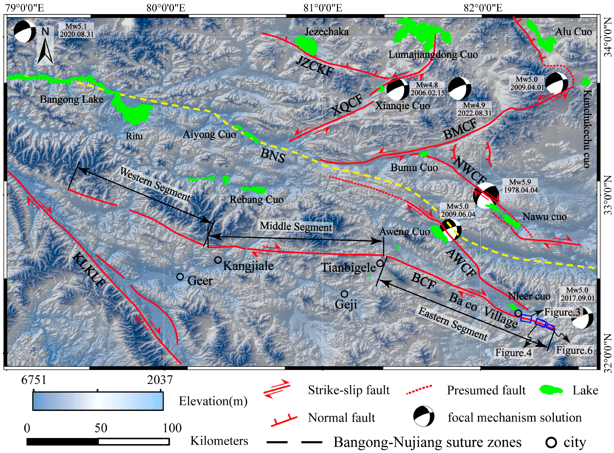
The average altitude of Geji County in the northern part of Ngari Prefecture, Xizang, is approximately 4800 m. Due to the intense regional tectonics, this area has formed an extremely complex geological tectonic environment, with intense neotectonic activities and well-developed fold activities. Multiple conjugate strike-slip fault systems are distributed around this area (Figure 1b and Figure 2) [1,5]. Among these structures, the BCF (abbreviated as BCF in figures) is situated in the southern Ngari Prefecture, Tibet (Figure 1b, BCF). It lies south of the Bangong-Nujiang Suture Zone within the Lhasa Terrane, and regionally belongs to the large-scale Shiquanhe-Jiali thrust-slip deformation zone. The geological structure of this area is complex, with surface structural features primarily including faults, folds, joints, lineations, and cleavages [27]. The Ba Co Fault develops within a synclinal fold belt, where a series of secondary faults occur within the Cretaceous strata. These secondary faults predominantly exhibit near E–W (east–west) and NW-trending (northwest) structural orientations. The western segment of the Ba Co Fault strikes northwest (Figure 2). The lithologies on both sides of the fault are primarily Cretaceous ophiolitic mélange zones. The central segment trends approximately east–west. To the south of the fault, the lithology consists mainly of Cretaceous limestone, conglomerate, and quartz sandstone interbedded with mudstone, while to the north, it is dominated by Jurassic-Triassic quartz sandstone, and calcareous and argillaceous siltstone, with minor granitic rocks. The eastern segment (Figure 2) is characterized by Cretaceous carbonates on the southwestern side, primarily composed of bioclastic limestone, crystalline limestone, quartz sandstone interbedded with mudstone, as well as intercalated carbonates and diorite. On the northeastern side, scattered outcrops of Paleogene conglomerate, feldspathic sandstone interbedded with siltstone and mudstone, are present. The eastern segment of the Ba Co Fault (Figure 2) (BCF) primarily extends east of Geji County. Its northern side is bounded by the Aweng Co Fault, with which it nearly intersects at its southern terminus (Figure 2). Previous studies have detailed the kinematic characteristics of the conjugate strike-slip fault pair comprising the Qixiang Co and Geren Co faults in central Tibet [28,29,30,31,32]. Research by Yang et al. [29,30] indicates the Geren Co Fault functions primarily as a transtensional dextral strike-slip fault with significant normal faulting components, while the northern Qixiang Co Fault exhibits dominantly sinistral strike-slip motion [28]. Additionally, investigations have addressed the geometric configurations and activity characteristics of the Aweng Co, Nawu Co, Huamu Co Bum Co, Xianqie Co, and Jieze Caka faults [33,34,35] (Figure 2). The Quaternary activity of the Bum Co conjugate strike-slip system (composed of the NE-striking Bum Co Fault and NW-striking Nawu Co Fault) and the Changtiao Lake conjugate fault system (formed by the NW-striking Changtiao Lake Fault and NE-striking Tuoheping Lake Fault Zone) surrounding the Ar Co Graben in Ngari has also been studied [33,34]. To date, research on the activity characteristics of the BCF remains unstudied. Therefore, this investigation focuses on the newly discovered co-seismic surface rupture zone along the eastern segment of the Ba Co Fault (Figure 2). This work will help fill the research gap regarding the kinematics of active faults within the northern Qiangtang Terrane in Ngari and provide critical insights for understanding deformation modes of active structures in the interior Tibetan Plateau.

3. Data and Methods

3.1. UAV Photogrammetry

In recent years, UAV (unmanned aerial vehicle) photogrammetry has become a vital tool in active tectonic research [36,37,38]. By acquiring high-resolution topographic data, this technology demonstrates significant advantages in the detailed study of seismic surface rupture zones. In this study, a DJI Phantom 4 RTK quadcopter equipped with an FC6310R camera was deployed for low-altitude aerial surveys over the eastern segment of the BCF. The flight altitude was set to 100 m, with along-track and cross-track overlap rates of 80% and 70%, respectively, yielding orthoimages with a ground resolution of 0.2 m. The data were processed using Agisoft Metashape Professional software (Version 1.6.2) to generate a digital elevation model (DEM) with a spatial resolution of 0.2 m (Figure 4 and Figure 6). This technique not only effectively identifies micro-topographic features associated with strike-slip faults (e.g., fault scarps and pull-apart basins) but also enables quantitative three-dimensional morphological analysis to delineate the geometric parameters of surface rupture zones.

3.2. Optically Stimulated Luminescence (OSL) Dating

Optically stimulated luminescence (OSL) dating has been widely applied in Quaternary geology, geomorphology, active tectonics, and related disciplines. It represents an effective, reliable, and practical method for resolving chronological issues in Late Quaternary sediments [39,40,41,42]. In this study, all sample pretreatment and testing were conducted at the Luminescence Dating Laboratory of the Lanzhou Institute of Seismology, China Earthquake Administration. Sample collection strictly adhered to light-exclusion protocols. Final ages were calculated with uncertainties constrained within ±10% (see Table 1 for chronological results). Key experimental procedures included the following: During sample collection, approximately 30 cm of surface material was first removed; sediment collection was then performed under light-shielded conditions using stainless steel cylinders (~5 cm diameter). In a dark environment, organic matter and carbonates were removed from the samples using 30% hydrogen peroxide (H2O2) and 10% hydrochloric acid (HCl), respectively. Quartz grains with a size range of 63–90 μm were separated using heavy liquid flotation with sodium polytungstate at a density of 2.58 g/cm3. Quartz purity was verified by ensuring the infrared-stimulated luminescence (IRSL) to blue-light-stimulated luminescence (BLSL) ratio (was <5%). The equivalent dose (De) was measured using a Risø TL/OSLDA-20-C/D reader equipped with a 90Sr/90Y beta source, which delivered a dose at a rate of 0.089 + 0.002 Gy/s. The determination of environmental dose rates follows standard rules [43] to quantify the concentrations of radioactive elements such as U, Th, and K. Concentrations of uranium (U), thorium (Th), and potassium (K) were determined using inductively coupled plasma mass spectrometry (ICP-MS) at Chang an University. The environmental dose rate was subsequently derived from these radionuclide concentrations by applying the standard model established by Aitken [44]. The measurement process follows the single-aliquot regenerative-dose (SAR) protocol for quartz [43,44].

4. Characteristics of the BCF Activity and Eastern Segment Rupture

4.1. Geomorphic Features of the BCF

Based on remote sensing imagery and field-based surface investigations, the eastern terminus of the BCF is located ~20 km southeast of Ba Co Village. The fault strikes NW (approximately 330°) in its eastern section, extending westward. Approximately 32 km west of Ge ji County, the fault transitions to a NW-trending orientation, continuing northward to the area north of Dumuqilie (Figure 2). The BCF exhibits an overall NW-to-near-E–W-trending geometry, with predominantly NW-striking segments at both termini and a near E–W-striking central section. The total fault length is approximately 316 kms. According to its geometric distribution observed in imagery, the BCF can be divided into three segments: western, central, and eastern. According to the geometric distribution characteristics of the images, the BCF can be divided into three sections: the west, middle, and east (Figure 2).
The western segment of the BCF trends NW along the northern flank of Kangjiale in Ngari. This segment displaces bedrock massifs and exhibits well-defined linearity, but shows no evidence of recent geomorphic offsets. Extending from Kangjiale in the west to Tianbigele in the east, the central segment trends approximately E–W (Figure 2). It offsets piedmont ridges and alluvial fans, creating linear troughs with clear surface expression. However, no discernible displacement is observed in younger alluvial fans. The eastern segment stretches from Tianbigele to the east of Baco Village, displaying NW-trending geometry. Pronounced evidence of recent tectonic activity characterizes this segment.
The eastern segment of the Ba Co Fault exhibits generally prominent surface traces in remote sensing imagery. In the eastern section, the fault traces are clear. The fault has broken the ridge and the Holocene alluvial fan in front of the mountain, forming some small gullies and reverse ridges. At the same time, some ridges and gullies have turned right and formed a fault-blocking lake. At the same time, on the south side of Neer Co, the Holocene alluvial layer in front of the faulted mountain has developed a series of surface rupture zones on the alluvial fan, and the right-turning signs retained in some gullies are clearly visible. This research focuses on providing a detailed description of the geomorphology and the characteristics of the fracture zone in the eastern section, and defines the formation time of the surface fracture zone by the age of the luminous samples on the T1 terrace (Figure 4 and Figure 5d).

4.2. Geomorphic and Developmental Characteristics of the Eastern Segment Surface Rupture
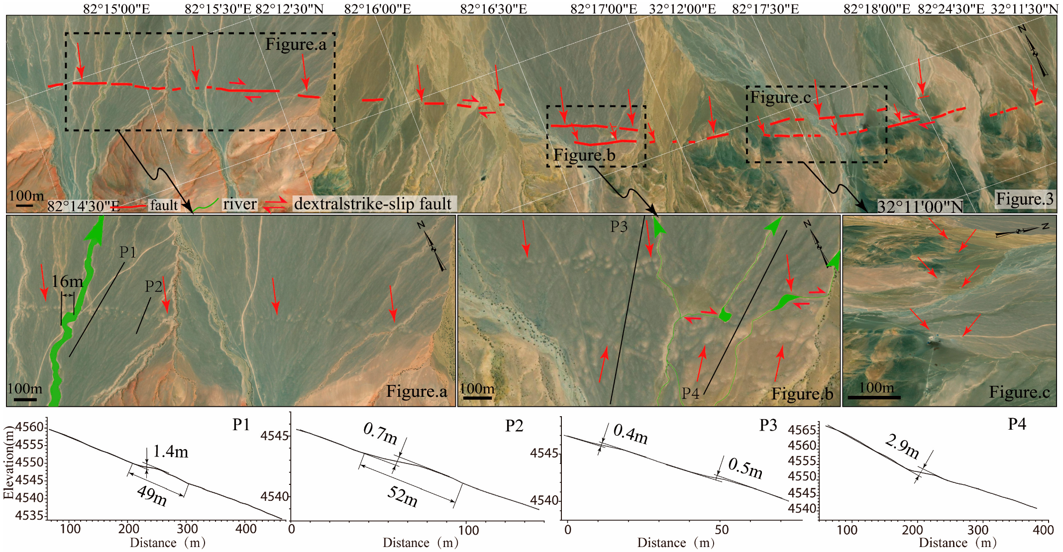
Site 1 is situated south of Nieer Co and approximately 2 km southwest of Ba Co Village, where the fault trends NW (Figure 2 and Figure 3). Satellite imagery interpretation reveals the displacement of multi-stage Holocene piedmont alluvial fans at this site. The fault trace exhibits pronounced linearity in imagery, offsetting older alluvial deposits to form subdued counter-slope scarps and dextrally offset gullies (Figure 3a,b). Concurrently, a ~4-km-long surface rupture zone has developed across the youngest alluvial fan. Topographic profiles (P1–P4 in Figure 3) were surveyed at locations exhibiting clear surface expressions of this rupture in imagery. This rupture segment features mole tracks (pressure ridges) ranging in height from 0.4 m to 2.9 m, with the majority measuring less than 1.4 m. Distinct dextral offsets are observed in several gullies, including a measured 16 m displacement (Figure 3a). As shown in Figure 3b, dextral fault motion has caused significant right-lateral deflection of two drainage channels, accompanied by the formation of a small sag pond.
At Site 1, the fault has generated a set of compressional-shear fractures (P) and low-angle Riedel shears (R), which intersect the main fault trace (Figure 3b,c). At this location, P3 and P4 measurement lines are laid out. For P3, it can be seen that near the east measurement, the retaining threshold height is 0.5 and 0.4 m, respectively. However, the closer to the intersection position, the greater the horizontal misalignment, and the larger the vertical misalignment. The P4 survey line is 2.9 m long. However, the northern section of P4 lacks well-preserved scarp morphology, likely due to subsequent fluvial erosion.
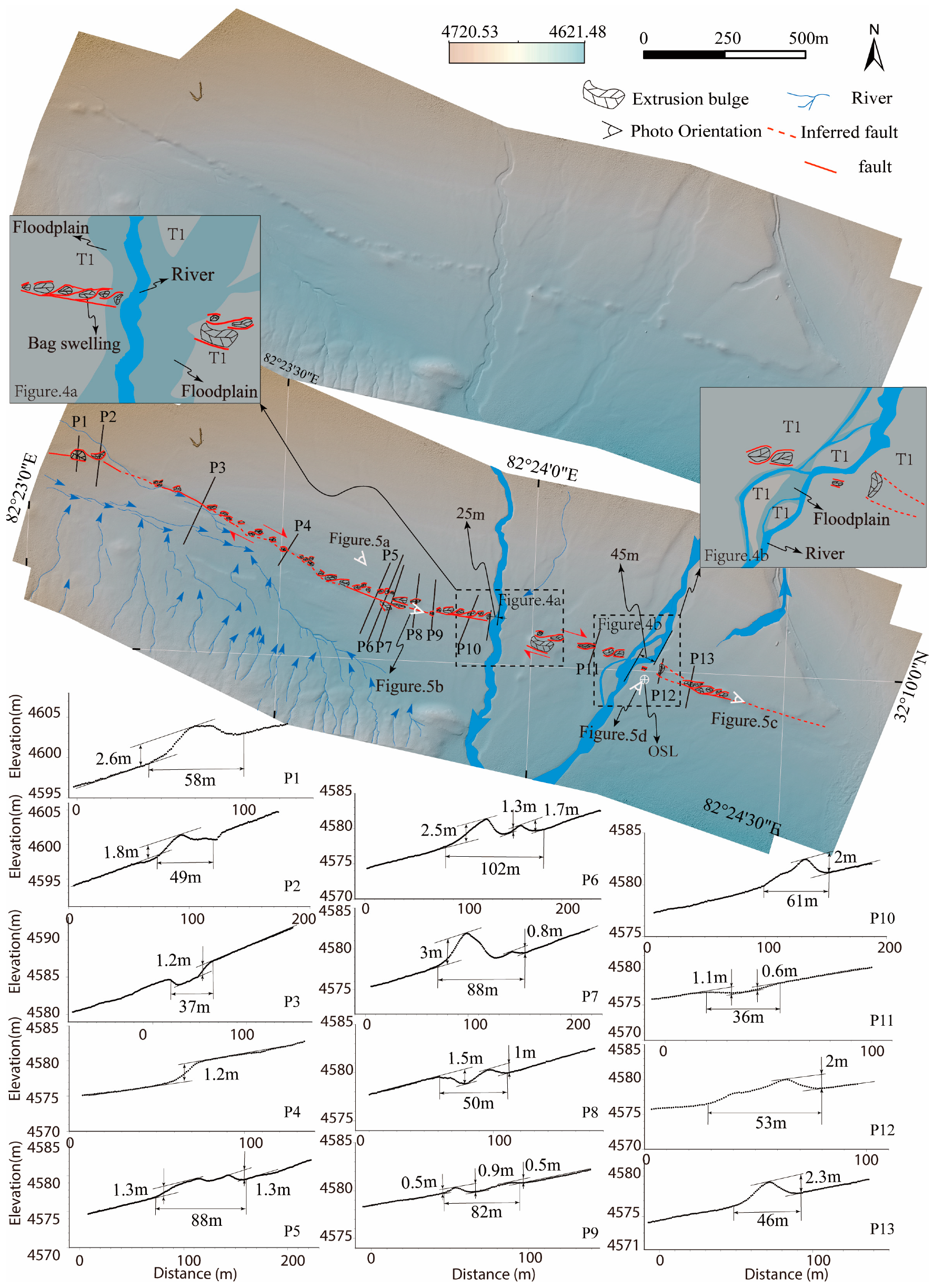
Research Site 2 is located 8 km east of Site 1 (Figure 2 and Figure 4). The fault at this site trends NW, with a surface rupture zone extending approximately 3 km. The rupture zone at Site 2 exhibits better preservation and greater continuity compared to Site 1 (Figure 4 and Figure 5a). The fault has developed a surface rupture zone on the new alluvial fan. Although it has undergone gullies and surface erosion and weathering, the rupture zone at this point is relatively well-preserved throughout the Baco Fault Zone. A high-resolution digital elevation model (DEM) with a spatial resolution of 0.2 m was generated from a UAV aerial survey (Figure 4), allowing for the detailed measurement of the morphological characteristics of the rupture zone.
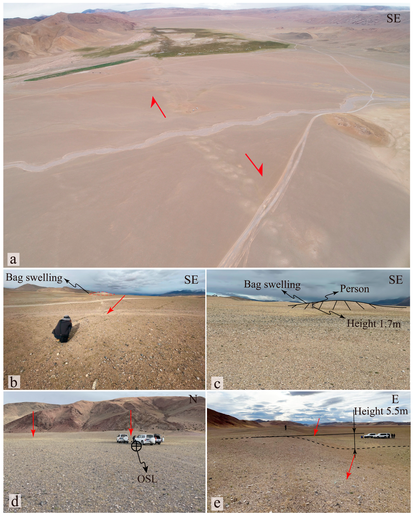
Further interpretation at Site 2 reveals the rupture zone mainly spreads out in a left-step formation, forming compression bulges and grooves. The fault diverts the river in a right-rotating manner, with a right-rotating dislocation of 25–45 m (Figure 4). Due to gully erosion in the western section, two intact pressure ridges are well-preserved. Profiles P1 and P2 (Figure 4) document ridge heights of 1.8–2.6 m and widths of 49–58 m. Further west, erosion along the rupture zone has partially destroyed ridges, leaving remnant scarps (1.2 m high) and incised channels at P3 and P4. The central zone exhibits optimal preservation, where multiple profiles (P5–P10) reveal well-defined pressure ridges (0.5–3 m high) and troughs. Some of the trenches have been filled with surface coverings. The depth of the trenches measured by the profiles of the P6, P7, and P11 survey lines is between 0.6 and 1.5 m (Figure 5c). The total rupture width at this site ranges from 36 to 102 m.
Figure 5. Typical geomorphic photos of research points 2 and 3 on the eastern section of the Ba Co Fault. (a) Rupture zone landform; (b,c) Rupture zone and pressure ridge; (d) Fault scarp and OSL sampling location; (e) Fault scarp.
Geosciences 15 00377 g005
Research Site 3 is situated 3 km east of Site 2 (Figure 2 and Figure 6). The fault at this location trends NW, with a surface rupture zone extending approximately 1.2 km. The fault at this point is developed at the leading edge of the alluvial on the south side. At the same time, it is eroded by the near E–W flowing river. In terms of topography, this point retains the bulges formed by the fault rupture zone and the right rotation of the river gully.
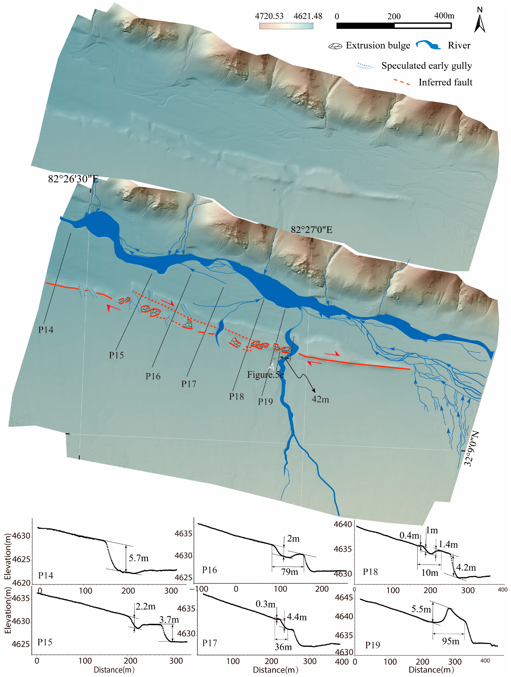
The area between the western part of Site 3 and Site 2 lies at the lowest elevation (Figure 4 and Figure 6), where alluvial–proluvial deposits from the west and southeast converge. This convergence and subsequent erosion have created a small, flat oasis, likely erasing the central portion of the rupture zone. The interpretation of the digital elevation model (DEM) at Site 3 reveals that the western rupture zone is nearly obliterated by fluvial erosion. However, older gullies exhibit right-lateral offsets, and Figure 6 demonstrates east-to-west decreasing topographic relief, with right-lateral stream deflections tapering westward. Sparse compressional ridges are preserved in the west, while the eastern rupture zone features numerous ridges and scarps (Figure 5e). Topographic profiles P17–P19 (Figure 6) indicate maximum ridge heights of 5.5 m (Figure 5c), minor ridges of 0.3 m, and a maximum rupture zone width of ~30 m. The largest right-lateral stream displacement observed here is 42 m. Compared to Site 2, the height of the bulge at this point is the highest.
Figure 6. Interpretation of fault rupture zone geometry and diagnostic tectonic landforms at Site 3 of the BCF (DEM-based analysis from UAV photogrammetric survey). P14–P19 are survey lines for the profiles.
Geosciences 15 00377 g006

5. Chronological Constraints on Surface Rupture Zones

The interpretation of high-definition images, geomorphological analysis, and field investigation results shows that the eastern section of the BCF is highly active and a fracture zone has been found on the surface. To constrain the timing of activity on this segment, two optically stimulated luminescence (OSL) samples were collected at Site 2 (Figure 4 and Figure 5d).
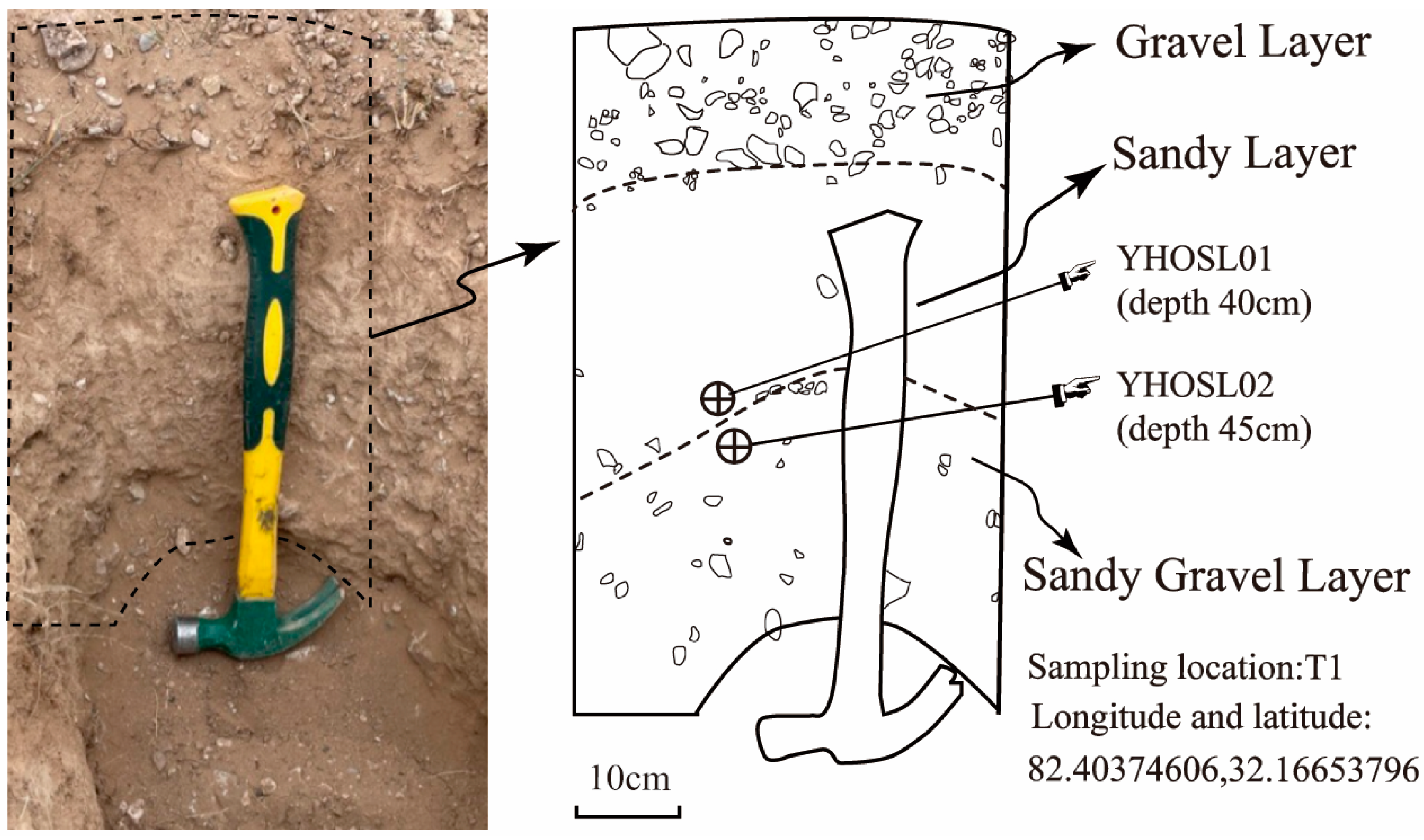
A small sampling pit measuring 70 cm in depth and 30 cm in width was excavated on the T1 terrace (Figure 4 and Figure 5d), with its configuration documented in Figure 7. At depths of 0.40 m and 0.45 m below the surface, one optically stimulated luminescence (OSL) sample was collected from each level. The results are presented in Table 1. The pit revealed a gravel layer with a sandy matrix from 0.10 m below the surface. This layer is loose and contains abundant small, subangular to angular clasts, indicating poor rounding. The underlying layer consists of sandy soil with sparse gravel; it is also relatively loose. From the lower part of this sandy layer, OSL sample YHOSL01 was collected, yielding an age of 5.73 ± 0.17 ka. The lowermost layer is predominantly a sandy gravel layer containing larger angular clasts. From the upper part of this layer, a second OSL sample, YHOSL02, was collected, yielding an age of 5.99 ± 0.15 ka. The newly discovered co-seismic surface rupture zone occurs on the T-1 terrace. OSL dating constrains the age of the T-1 terrace surface to 5.73 ± 0.17 ka. This implies that at least one major earthquake capable of generating surface rupture has occurred since 5.73 ± 0.17 ka. Consequently, the formation of the co-seismic surface rupture zone along the eastern segment of the BCF is constrained to after 5.73 ± 0.17 ka.

6. Discussion

6.1. Magnitude Estimation for the Co-Seismic Surface Rupture Along the Eastern Segment of the BCF

There exists an intrinsic relationship between surface faulting and seismic rupture processes. The magnitude of an earthquake can be estimated based on parameters such as the length of the surface rupture zone of the earthquake and the co-seismic displacement. For strike-slip faults, the surface rupture length (SRL) and moment magnitude (M) are commonly correlated via the following empirical formula [45].
M = 5.16 + 1.12log10 (SRL)
Based on data from high-resolution imagery interpretation, UAV aerial surveys, and field investigations of the co-seismic surface rupture zone along the BCF, the strike-slip displacement ranges approximately from 16 to 52 m. Clearly, the minimum displacement of 16 m cannot be attributed to a single co-seismic event from the most recent earthquake. The surface rupture zone along the eastern segment of the BCF extends for ~21 km. Estimating the magnitude using empirical relationships between surface rupture length and earthquake size yields a value of approximately M 6.6. However, the absence of discrete co-seismic offsets suggests the 16 m displacement likely represents cumulative slip from multiple seismic events. These findings demonstrate the capacity of the eastern BCF to generate earthquakes exceeding M 6. Studies of adjacent strike-slip and normal faults—including the Na Co, Xianqie Co, Bumu Co, Burga Co, and Aru Co Faults [33,35,45]—reveal that surrounding structures possess potential for major earthquakes (M ≥ 6), with some capable of reaching M ≥ 7. Synthesizing these results with existing research, the eastern BCF segment exhibits high contemporary activity and poses a significant seismic hazard.

6.2. Regional Tectonic Implications of the Rupture Zone Along the Eastern BCF Segment

A series of en echelon fault systems have developed on both the north and south sides of the Bangonghu-Nujiang Fault Zone. Among them, in northern Xizang, there is mainly a coexistence of near-north–south normal faults and northeastward and northeastward strike-out faults, which may mainly regulate the deformation through extrusion–extension action [16,17], but the specific details are still not clear enough [33]. The V-shaped conjugate strike-slip faults extend eastward and connect with N-S trending rifts, reflecting an extensional stress regime oriented E-W. Wu et al. [33] investigated two pairs of conjugate strike-slip fault systems in northern Ngari: the Bumu Co fault system and the Changtiao Hu conjugate fault system. The Bumu Co Fault exhibits typical strike-slip deformation features, including sinistral rhombic pull-apart basins and shutter ridge ponds. At its intersection with the Na Co Fault, it forms a characteristic triangular extensional depression. Surface expressions of the Changtiao Hu Fault are more prominent, displaying extensional depressions at right-stepping fault bends—morphotectonic features indicative of localized extension accompanying strike-slip motion. Previous studies on the Geren Co Fault also reveal prominent transtensional characteristics [19,32]. The BCF lies south of the Na Co Fault, with its eastern segment nearly intersecting the latter. The geomorphic analysis of the eastern BCF segment demonstrates dominantly transpressional kinematics, evidenced by pressure ridges and associated compressional-shear rupture features, collectively indicating a strike-slip motion with a significant compressional component.
Research on conjugate strike-slip fault systems in central Tibet has yielded multiple shear models. The simple shear model proposes the Karakoram-Jiali Fault Zone as a continuous southern boundary of the Qiangtang Block [16,46]. This model suggests the entire Qiangtang Block undergoes eastward transport north of this fault, with its dextral motion generating terminal extensional faults—manifested as the widespread N–S trending rift systems in southern Tibet [16,46]. Alternatively, the pure shear model of contractional conjugate structures posits that NE-trending sinistral strike-slip faults—coexisting with NW-trending dextral faults—pervasively dissect the Qiangtang Block, collectively forming a multi-set conjugate system along the Karakoram-Jiali Fault Zone [19]. Under the N–S India–Asia convergence, wedges between conjugate faults extrude eastward, challenging the simple shear paradigm [10,11,19,47]. Additionally, Yang et al. [19] proposed a shear-extensional model: Following the India–Asia collision, the Tibetan crust experienced compressional thickening. Intensive middle-lower crustal uplift near the Bangong-Nujiang Suture caused upper-crustal decoupling, inducing E–W and N–S extensional stresses. Accompanying Neogene differential uplift-subsidence that reversed the Paleogene eastern-high topography, gravity-driven eastward upper-crustal flow established the modern west-high–east-low orogen. This process generated asymmetric conjugate faulting [48]. The kinematic behavior of the eastern BCF aligns with the second model (pure shear). However, studies of the Bumu Co and Changtiao Hu conjugate systems support the third model (shear-extension). Geophysical evidence indicates the shear-extension domain has a limited N–S extent [19]. Consequently, whether the BCF’s distinct shear regime functions as a boundary between these domains requires further integrated analysis. Kinematic analysis indicates the eastern fault segment operated under NW-directed compression during the Holocene, consistent with transpressional dextral strike-slip motion. Unlike the transtensional shear observed in adjacent conjugate faults, the role of this segment within existing regional shear models requires further multidisciplinary investigation.

7. Conclusions

Integrating the geomorphic characteristics of the BCF in the Ngari region with the newly discovered co-seismic surface rupture along its eastern segment, this comprehensive analysis yields the following key findings:
(1)
The eastern segment of the BCF is a Holocene-active right-lateral strike-slip fault. Geomorphically, it displaces Holocene alluvial–fluvial fans and partially offsets ridges along the mountain front. Associated landforms include pressure ridges, linear erosional trenches, counter-slope scarps, and shutter ridge ponds. Selected gullies exhibit dextral offsets ranging from 16 to 45 m.
(2)
A newly mapped ~21-km-long co-seismic surface rupture zone extends along Holocene alluvial–fluvial fans at the mountain front. This rupture displays a left-stepping en echelon pattern dominated by pressure ridges (0.30–5.5 m high) and trenches (0.60–15 m deep), within a total width of 30–102 m. OSL dating of samples from the T1 terrace constrains the formation of the surface rupture zone to post- 5.73 ± 0.17 ka.

Author Contributions

Conceptualization, Y.Y. and Y.S.; methodology, Y.Y. and Y.S.; investigation, Y.Y.; validation, B.Z. and Y.S.; writing—original draft preparation, Y.Y.; writing—review and editing, Y.Y., B.Z. and Y.S.; supervision, B.Z.; project administration, B.Z.; funding acquisition, Y.S. All authors have read and agreed to the published version of the manuscript.

Funding

This research was funded by the Special Project of Basic Scientific Research Operating Expenses, the Institute of Earthquake Forecasting, China Earthquake Administration grant number (2021IESLZ06), the Natural Science Foundation Project of the Gansu Provincial Science and Technology Program grant number (24JRRA1187), and the Second Tibetan Plateau Scientific Expedition and Research Program (STEP) grant number (2019QZKK0901).

Data Availability Statement

The original contributions presented in this study are included in the article. Further inquiries can be directed to the corresponding author(s).

Conflicts of Interest

The authors declare no conflict of interest.

References

  1. Molnar, P.; Tapponnier, P. Cenozoic tectonics of Asia: Effects of a continental collision. Science 1975, 1989, 419–426. [Google Scholar] [CrossRef] [PubMed]
  2. Tapponnier, P.; Peltzer, G.; Le Dain, A.Y.; Armijo, R.; Cobbold, P. Propagating extrusion tectonics in Asia: New insights from simple experiments with plasticine. Geology 1982, 10, 611–616. [Google Scholar] [CrossRef]
  3. Tapponnier, P.; Zhiqin, X.; Roger, F.; Meyer, B.; Arnaud, N.; Wittlinger, G.; Jingsui, Y. Oblique stepwise rise and growth of the Tibet Plateau. Science 2001, 294, 1671–1677. [Google Scholar] [CrossRef] [PubMed]
  4. Molnar, P.; England, P.; Martinod, J. Mantle dynamies, uplift of the Tibetan plateau, and the Indian monsoon. Rev. Geophys. 1993, 31, 357–396. [Google Scholar] [CrossRef]
  5. Dewey, J.; Shackelton, R.; Chang, C.; Sun, Y. The tectonic evolution of the Tibetan plateau. Philos. Trans. R. Soc. London Ser. A Math. Phys. Sci. 1988, 327, 379–413. [Google Scholar]
  6. Molnar, P.; Lyon-Caen, H. Fault-plane solutions of earthquakes and active tectonies of the Tibetan plateau and its margins. Geophys. J. Int. 1989, 99, 123–153. [Google Scholar] [CrossRef]
  7. Xu, Z.; Li, H.; Yang, J. Orogenic Plateau: The Giant Orogenic Collage and Orogenic Types of the Tibetan Plateau. Earth Sci. Front. 2006, 13, 1–17. [Google Scholar]
  8. Molnar, P.; Tapponnier, P. Active tectonics of Tibet. J. Geophys. Res. Solid Earth 1978, 83, 5361–5375. [Google Scholar] [CrossRef]
  9. Tapponnier, P.; Molnar, P. Active faulting and tectonics in China. J. Geophys. Res. 1977, 82, 2905–2930. [Google Scholar] [CrossRef]
  10. Yin, A.; Harrison, T.M. Geologic evolution of the Hima-layan-Tibetan Orogen. Annu. Rev. Earth Plane-Tary Sci. 2000, 28, 211–280. [Google Scholar] [CrossRef]
  11. Taylor, M.; Yin, A.; Ryerson, F.J.; Kapp, P.; Ding, L. Conjugate strike-slip faulting along the Bangong-Nujiang suture zone accommodates coeval east-west extension and north-south shortening in the interior of the Tibetan Plateau. Tectonies 2003, 22, 1044–1068. [Google Scholar] [CrossRef]
  12. Ding, L.; Yue, Y.H.; Cai, F.L.; Xu, X.X.; Zhang, Q.H. High-Mg ultrapotassic volcanic rocks in the Lhasa Block, Tibet: Constraints on the timing and depth of N-S-trending rift formation. Acta Geol. Sin. 2006, 80, 1252–1261. [Google Scholar]
  13. Armijo, R.; Tapponnier, P.; Mereier, J.L.; Han, T.-L. Quatermary extension in souther Tibet: Field observations and tectonic implications. J. Geophys. Res. Solid Earh 1986, 91, 13803–13872. [Google Scholar] [CrossRef]
  14. Allegre, C.J.; Courtillot, V.; Tapponnier, P.; Hirn, A.; Mattauer, M.; Coulon, C.; Jaeger, J.J.; Achache, J.; Schärer, U.; Marcoux, J.; et al. Structure and Evolution of the Himalaya-Tibet Orogenic Belt. Nature 1984, 307, 17–22. [Google Scholar] [CrossRef]
  15. Bian, S.; Yu, Z.; Gong, J.; Yang, R.; Cheng, X.; Lin, X.; Chen, H. Spatiotemporal distribution and geodynamic mechanism ofthe nearly NS-trending rifts in the Tibetan plateau. J. Geomech. 2021, 27, 178–194. (In Chinese) [Google Scholar]
  16. Rothery, D.A.; Drury, S.A. The neotectonies of the Tibetan plateau. Tectonics 1984, 3, 19–26. [Google Scholar] [CrossRef]
  17. Ratschbacher, L.; Krumrei, I.; Blumenwitz, M.; Staiger, M.; Gloaguen, R.; Miller, B.V.; Samson, S.D.; Edwards, M.A.; Appel, E. Rifting and strike-slip shear in central Tibet and the geometry, age and kinematics of upper crustal extension in Tibet. Geol. Soc. Lond. Spec. Publ. 2011, 353, 127–163. [Google Scholar] [CrossRef]
  18. England, P.; Houseman, G. Role of lithospherie strength heterogeneities in the tectonies of Tibet and neighboringregions. Nature 1985, 315, 297–301. [Google Scholar] [CrossRef]
  19. Yang, P.; Chen, Z.; Zhang, J.; Ren, J. The tension-shear of Gyaring Co Fault and the implication for dynamic model in south-central Tibet. Chin. Joumal Geophys. 2012, 55, 3285–3295. (In Chinese) [Google Scholar]
  20. Chang, C.F.; Chen, N.S.; Coward, M.P.; Wanming, D.; Dewey, J.F.; Gansser, A.; Harris, N.B.W.; Chengwei, J.; Kidd, W.S.F.; Leeder, M.R.; et al. Preliminary Conclusions of the Royal Society and Academia Sinica 1985 Geotraverse of Tibet. Nature 1986, 323, 501–507. [Google Scholar] [CrossRef]
  21. Wei, W.B.; Jin, S.; Ye, G.F.; Deng, M.; Tan, Z.; Unsworth, M.; Jones, A.G.; Booker, J. Conductivity structure of crust and upper mantle beneath the northern Tibetan Plateau:Results of superwide band magnetotelluric sounding. Chin. J. Geophys. 2006, 49, 1215–1225. (In Chinese) [Google Scholar]
  22. Kapp, P.; DeCelles, P.G.; Gehrels, G.E.; Heizler, M.; Ding, L. Geological Records of the Lhasa-Qiangtang and Indo-Asian Collisions in the Nima Area of Central Tibet. Geo-Log. Soc. Am. Bull. 2007, 119, 917–933. [Google Scholar] [CrossRef]
  23. Li, S.; Yin, C.; Guilmette, C.; Ding, L.; Zhang, J. Birth and Demise of the Bangong-Nujiang Tethyan Ocean: A Review from the Gerze Area of Central Tibet. Earth-Sci. Rev. 2019, 198, 102907. [Google Scholar] [CrossRef]
  24. Zeng, Q.G.; Wang, B.D.; Xi, L.; Mao, G.Z.; Liu, H.Y.; Liu, G.X. Suture zones in Tibet and the evolution of the Tethys. Earth Sci. 2020, 45, 2735–2763. [Google Scholar]
  25. Taylor, M.; Yin, A. Active structures of the Himalayan-Tibetanorogen and their relationships to earthquake distribution, contemporary strain field, and Cenozoic volcanism. Geosphere 2009, 5, 199–214. [Google Scholar] [CrossRef]
  26. Zhang, J.J.; Ding, L. East west extension of the Tibetan Plateau and its geological significance. Sci. Geol. Sin. 2003, 38, 179–189. [Google Scholar]
  27. Wang, Y. Tectonic Geomorphology of the Geji Fault Zone in Central Tibetan Plateau. Master’s Thesis, Chengdu University of Technology, Chengdu, China, 2010. [Google Scholar]
  28. Li, K.; Wang, D.; Shao, Q.; Xu, X. Holocene slip rate along the NE-rending Qixiang Co Fault in the eentral Tibetan plateau and its tectonic implications. Seismol. Geol. 2018, 40, 1204–1215. (In Chinese) [Google Scholar]
  29. Yang, P.X.; Chen, Z.W.; Ren, J.W.; Zhang, J. Activity and Segments of Gyaring Co Fault Zone in Center Tibet Plateau. Acta Seismol. Sin. 2011, 33, 362–372. (In Chinese) [Google Scholar]
  30. Yang, P.X. Late Quaternary activity and regional dynamics of the Geren Fault in central-southern Tibet. Recent Dev. World Seismol. 2015, 7, 44–46. [Google Scholar]
  31. Wang, D. Late Quaternary activity of the Geren Fault. Master’s Thesis, China University of Geosciences, Beijing, China, 2014. [Google Scholar]
  32. Wang, D. Tectonic Geomorphology Along the Gyaring Co Fault in Central Tibet; China Earthquake Administration Institute o Geology: Beijing, China, 2018. (In Chinese) [Google Scholar]
  33. Wu, Z.H.; Zhang, X.D.; Han, S.; Shi, Y.R.; Gao, Y.; Ye, Q.; Nima, C.R. Quaternary active faults within the Qiangtang Block, northern Ngari, Tibet, and their deformation mechanisms. Acta Geol. Sin. 2022, 96, 3761–3777. [Google Scholar]
  34. Wu, Z.; Zhang, X.D.; Han, S.; Shi, Y.R.; Gao, Y.; Ye, Q.; Nimaciren; Zhang, B.; Li, Z.B. The Quatemary normal faulting and recent co-seismic surface rupture and related seismological significance along the Aru Co graben system in northem Ngari, Tibet. J. Seismol. Geol. 2023, 45, 67–91. [Google Scholar]
  35. Han, S.; Wu, Z.; Wang, S.; Gao, Y.; Zhang, S.; Lu, S.; Zhang, M. Surface deformation and tectonic implication of the late Quaternary Bue Co strike-slip fault system, mid-western Oiangtang block. J. Geomech. 2024, 30, 298–313. [Google Scholar]
  36. Bemis, S.P.; Micklethwaite, S.; Turner, D.; James, M.R.; Akciz, S.; Thiele, S.T.; Bangash, H.A. Ground-based and UAV-based photogrammetry: A multi-scale, high-resolution mapping tool for structural geology and paleoseismology. J. Struct. Geol. 2014, 69, 163–178. [Google Scholar] [CrossRef]
  37. Wang, P.T.; Shao, Y.X.; Zhang, H.P.; Liu, H.; Wu, Z. Application of SUAV photogrammetry in active tectonic studies: A case study of the Pianmagogou segment of the Haiyuan Fault. Quat. Sci. 2016, 36, 433–442. [Google Scholar]
  38. Ai, M.; Bi, H.Y.; Zheng, W.J.; Yin, J.H.; Yuan, D.Y.; Ren, Z.K.; Cheng, G.; Liu, J.R. Extraction of quantitative parameters of active tectonics using UAV photogrammetry. Seismol. Geol. 2018, 40, 1277–1289. [Google Scholar]
  39. Rhodes, E.J. Optically Stimulated Luminescence Dating of Sediments over the Past 200,000Years. Annu. Rev. Earth Planet. Sci. 2011, 39, 461–488. [Google Scholar] [CrossRef]
  40. Roberts, R.; Lian, O. llluminating the past. Nature 2015, 520, 438–439. [Google Scholar] [CrossRef]
  41. Murray, A.; Arnold, L.J.; Buylaert, J.-P.; Guérin, G.; Qin, J.; Singhvi, A.K.; Smedley, R.; Thomsen, K.J. Optically stimulated luminescence dating using quartz. Nat. Rev. Methods Prim. 2021, 1, 72. [Google Scholar] [CrossRef]
  42. Mahan, S.A.; Rittenour, T.M.; Nelson, M.S.; Ataee, N.; Brown, N.; DeWitt, R.; Durcan, J.; Evans, M.; Feathers, J.; Frouin, M.; et al. Guide for interpreting and reporting luminescence dating results. Geol. Soc. Am. Bull. 2022, 135, 1480–1502. [Google Scholar] [CrossRef]
  43. Lai, Z.P.; Ou, X.J. Basic procedures of optically stimulated luminescence dating. Prog. Geogr. 2013, 32, 683–693. [Google Scholar]
  44. Murray, A.; Wintle, A. The single aliquot regenerative dose protocol: Potential for improvements in reliability. Radiat. Meas. 2003, 37, 377–381. [Google Scholar] [CrossRef]
  45. Wells, D.L.; Coppersmith, K.J. New empirical relationships among magnitude, rupture length, rupture width. rupture area, and surface displacement. Bull. Seismol. Soc. Am. 1994, 84, 9741002. [Google Scholar] [CrossRef]
  46. Armijo, R.; Tapponnier, P.; Han, T. Late Cenozoic right-lateral strikeslip faulting in southern Tibet. J. Geophys. Res. 1989, 94, 2787–2838. [Google Scholar] [CrossRef]
  47. Taylor, M.; Peltzer, G. Current slip rates on conjugate strike-slip faults in central Tibet using synthetic aperture radar inter ferometry. J. Geophys. Res. 2006, 111, B12402. [Google Scholar] [CrossRef]
  48. Zhang, K.X.; Wang, G.C.; Cao, K.; Liu, C.; Xiang, S.; Hong, H.; Kou, X.; Xu, Y.; Chen, F.; Meng, Y.; et al. Cenozoie sedimentaryrecords and geochronological constraints of differential upliftof the Qinghai Tibet plateau. Sci. China 2008, 51, 1658–1672. [Google Scholar] [CrossRef]
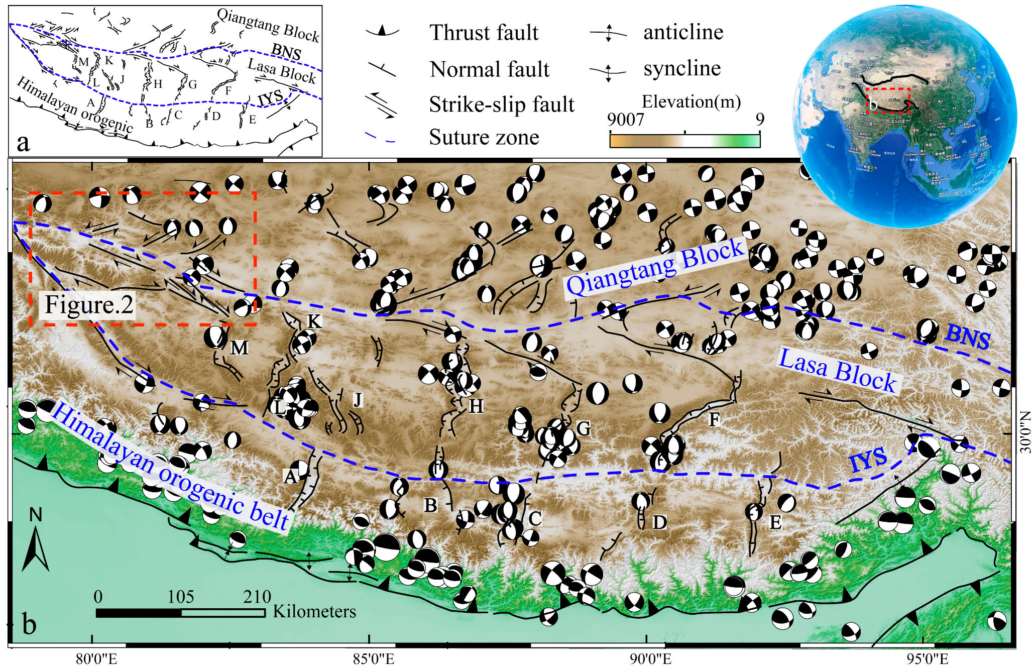
Figure 1. Tectonic sketch map of the south-central Tibetan Plateau. Focal mechanism solutions were obtained from the Global Centroid Moment Tensor (Global CMT) project database, accessible at accessed on 10 January 2025. (a) Tectonic sketch map. (b) Tectonic geomorphic map. IYS: Indus-Yarlung Suture Zone; BNS: Bangong-Nujiang Suture Zone; A: Thankkhola Rift Valley; B: Dingjie Rift Valley; C: Kong Co Rift Valley; D: Yadong Rift Valley; E: Cona Rift Valley; F: Nianqintanggula Rift Valley; H: Dangruoyong Co Rift Valley; M: Ya Re Rift; J: Lopukangri Rift Valley; K: North Longar Rift Valley Rift Valley; L: South Longar; and Rif; G: Shengzha Rift Valley.
Geosciences 15 00377 g001
Figure 2. Structural configuration of major active faults in the peripheral region of the study area. JZCKF: Jieze Chaka Fault; XQCF: Xianqie Co Fault; BMCF: Burmu Co Fault; NWCF: Nawu Co Fault; AWCF: Awong Co Fault; BCF: Ba Co Fault; and KLKLF: Karakorum Fault.
Geosciences 15 00377 g002
Figure 3. Distribution of the fault rupture zone and typical geomorphic features imagery at Site 1 along the eastern segment of the BCF (base map sourced from Google Earth; topographic profiles P1P4 were generated using the 91 Weitu Assistant tool: https://www.91weitu.com). (a,b): Antislope scarps and right-lateral offset of gullies. (b,c): A set of compressive-shearing fractures formed by the fault.
Geosciences 15 00377 g003
Figure 4. Interpretation of fault rupture zone distribution and diagnostic tectonic landforms at Site 2 in the eastern segment of the Ba Co Fault (DEM generated from UAV photogrammetric survey). P1–P13 are survey lines for the profiles. (a,b) are close-up views. Figure 5a–d are photographs showing the geomorphic features.
Geosciences 15 00377 g004
Figure 7. Photographs of OSL sample collection and stratigraphic profile documentation.
Geosciences 15 00377 g007
Table 1. OSL dating results for the eastern segment of the BCF.
Field No.Depth (m)Grain Size (μm)Aliquots (n)Equivalent Dose (Gy)OD (%)U
(ppm)
Th (ppm)K
(%)
Rb
(ppm)
Water Content (%)Dose Rate (Gy/ka)CAM Age (ka)
YH010.4063–9016/1626.90 ± 0.678 ± 23.10 ± 0.0318.74 ± 0.162.25 ± 0.02125.06 ± 0.793.544.69 ± 0.085.73 ± 0.17
YH020.4563–9016/1626.86 ± 0.3717 ± 33.08 ± 0.0217.87 ± 0.072.16 ± 0.03121.09 ± 1.694.454.49 ± 0.095.99 ± 0.15
Disclaimer/Publisher’s Note: The statements, opinions and data contained in all publications are solely those of the individual author(s) and contributor(s) and not of MDPI and/or the editor(s). MDPI and/or the editor(s) disclaim responsibility for any injury to people or property resulting from any ideas, methods, instructions or products referred to in the content.