Abstract
This paper presents a morphometric and structural-geomorphological approach to identifying morphotectonic features across an area underlain by lithologies that do not easily record tectonic deformations but are widely affected by seismic activity. The middle Biferno River Valley (Central Italy) was chosen as a study area. It was investigated through analyses performed from the drainage basin scale (Biferno River) to the local scale (Ponte Liscione Dam). This methodological approach was applied to investigate the impact of morphotectonic processes in the study area, providing a geomorphology-based contribution to landscape evolution. The aim of the work was to discriminate the main morphotectonic elements acting in the complex tectonic framework of the study area by means of a combination of morphometric, morphotectonic, and structural-geomorphological analyses. The resulting data allowed us to identify three main systems of tectonic elements (F1, F2, and F3), which are attributable to compressive and extensional kinematics, as already reported in previous thematic studies. The tectonic setting reflects the geodynamic framework of the Periadriatic region, as highlighted by the distribution of seismogenic sources and the historical to recent seismicity. Finally, the present work could act as a valuable scientific tool for any geomorphological studies aimed at better defining the impact of morphotectonic processes in similar tectonically active regions hosting important and strategic artificial dams.
1. Introduction
The evolution and modification of landscapes can be seen as a result of competition between uplift, weathering, and erosion, directly reflecting the interaction of endogenous and exogenous processes [1,2]. Therefore, although additional variables (i.e., climatic forcing [3,4]) should be considered, landscape features can record evolutionary history and conditions; they contain vital information about the past and present tectonic regimes [5,6]. From this perspective, the analysis of topographic adjustments, drainage system anomalies, and morphological field evidence of tectonics represents an important source of information on the long-term landscape evolution and a powerful tool to reconstruct both passive and active tectonic control in an area [7,8,9,10,11,12]. Indicative features to be considered in extracting tectonic information from topography and fluvial landscapes mainly include fluvial terracing [13,14], rearrangement of the drainage network [13,15,16,17], the retreat of escarpment and knickpoints [1,18,19], and effects derived from human intervention [20,21].
A wide range of works have already outlined the usefulness of morphometric and morphotectonic approaches in interpreting morpho-evolutive processes as well as in the study of tectonically active regions [22,23,24,25,26]. Particularly in this second case, morphometric analysis, morphotectonic indices, and the investigation of geomorphological features (i.e., triangular facets, hanging and beheaded valleys, river bends, rectilinear fluvial segments, and 90° and counterflow confluences) are considered reliable reconnaissance tools to differentiate zones deformed by tectonics, retrieving insights of tectonic deformation from landscape features [10,27,28,29,30,31,32]. This kind of analysis has gained rapid attention through the quantitative analysis and combination of Digital Elevation Models (DEMs), topographic maps, aerial photos, and field surveys. In this regard, the recent use of Geographic Information System (GIS) software strongly helps in performing analyses focused on the mapping of geomorphological features, which are possibly linked to the main morphotectonic processes acting in a given catchment or fault area [33,34,35,36].
The middle Biferno River Valley (Molise Region) is framed in the central-eastern sector of the Italian peninsula, extending from the eastern slope of the Apennine Chain towards the Adriatic Sea. Bedrock lithologies mainly refer to the clayey-marly allochthonous domain of the Molise Apennines, unconformably overlain by a complex sequence of Upper Pleistocene-Holocene superficial continental deposits. The present-day configuration of the landscape strongly reflects long-term geomorphological evolution, controlled by a combination of Plio-Quaternary tectonics, regional uplift, climate changes, and eustatic variation [37]. Moreover, the study area is located in a tectonically active region, whose seismicity need to be contextualized in the general framework of the central-southern Apennines, where several earthquakes have been documented by historical sources since the beginning of the 19th century [38,39] and listed in the historical and instrumental catalogues [40,41].
From a regional viewpoint, the tectonic setting is dominated by extension in the axial part of the chain, with intense seismicity and strong historical earthquakes (up to M 7.0); meanwhile, the Adriatic piedmont and the offshore areas are characterized by lower magnitudes and shallower earthquakes in a compressional domain on the outer thrust fronts and along E-W shear zone [42,43]. This seismic activity directly reflects the seismotectonic framework of the area and the spatial distribution of seismogenic sources [44,45]. Ultimately, the middle Biferno River Valley hosts an important and strategic water reservoir. It was created in the early seventies by damming the Biferno River, with the construction of the earthfill embankment of Ponte Liscione, to supply multiple water purposes (industrial, irrigational, drinkable, and hydroelectric) [46,47].
Previous studies, e.g., those in [37,48,49], were only concerned with the reconstruction of the main stages of the long-term evolution of a large portion of the central-southern Apennines, with poor references to the influence of tectonics on the geomorphological and morphotectonic characterization at the drainage basin scale, in contrast to that which has been widely studied for the neighboring sectors [50,51,52]. Hence, starting from this general framework, we selected this area to carry out an analysis in order to identify the main morphotectonic features, to act as significant tools for the definition and detection of landscape responses to drainage system anomalies and tectonic features.
The main goal of this paper is to provide new insights into the landscape evolution, focusing attention on the impact of morphotectonic processes in an area such as the middle Biferno River valley, where outcropping rocks do not readily record conventional markers of tectonic deformation. The applied morphometric and structural-geomorphological approach was revealed to be useful to directly achieve this goal. In particular, it is based on analyses performed from the drainage basin scale (Biferno River) to the local scale (Ponte Liscione Dam), providing intriguing elements for delivering a geomorphology-based contribution to landscape and morphotectonic reconstructions.
Finally, this work may provide a methodological contribution to any geomorphological studies aimed at increasing the geological knowledge and hazard assessment in tectonically active areas that host important artificial water reservoirs, are characterized by Quaternary morphogenetic processes, and are affected by historical to recent seismic activity.
2. Regional Geological, Structural, and Seismic Settings
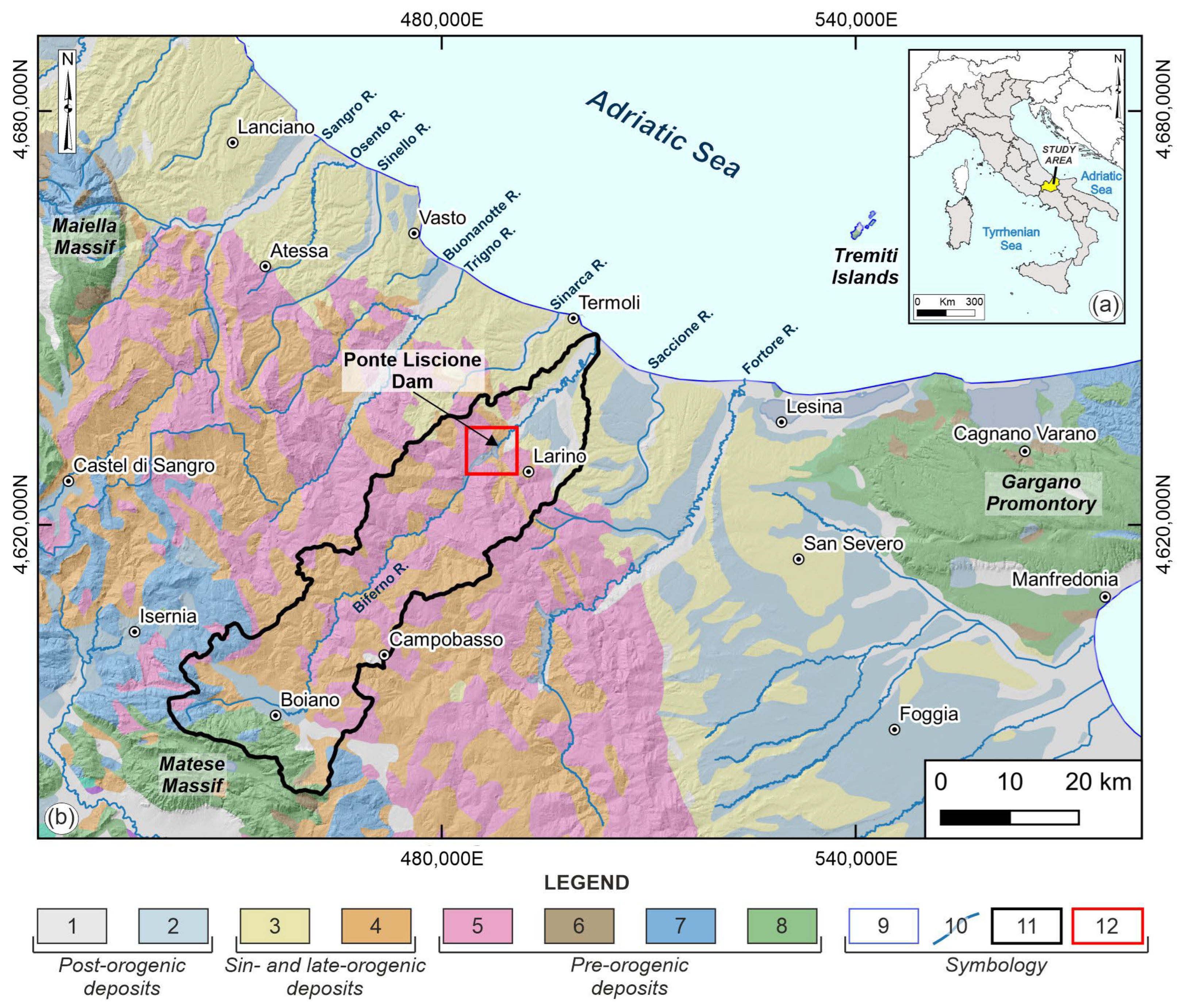
The Biferno River basin is located in the central-eastern sector of the Italian peninsula, within the Molise Region (Figure 1a). The studied basin extends from the outer sectors of the central-southern Apennine Chain, a typical fold-and-belt system with an eastern vergence, located between the Tyrrhenian Basin to the west and the Apulia Foreland to the east [53,54,55]. Pre-orogenic deposits (Figure 1b) mainly refer to carbonate ramp and platform limestones, slope-to-pelagic limestones, and marls, representing the backbone extending from the internal ridges (i.e., Matese Massif) to the Gargano Promontory, and to clayey-marly allochthonous deposits that characterize the easternmost sectors of Abruzzo-Molise Apennines [56].
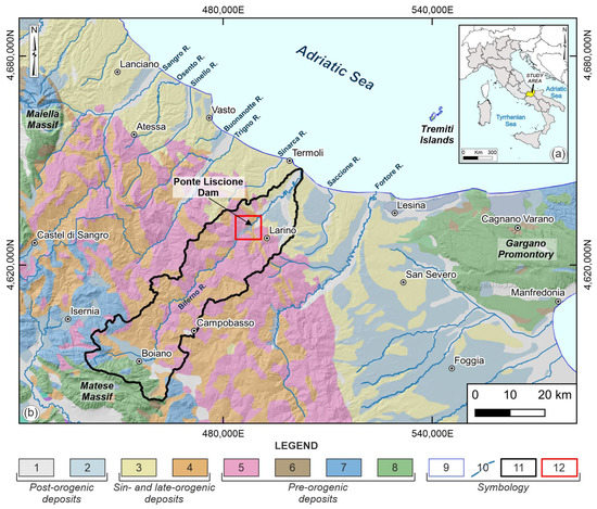
Figure 1.
(a) Location map of the study area in Central Italy; (b) geolithological sketch map of the central-southern Apennines and Periadriatic areas (modified from [57,58]). Legend: Post-orogenic deposits: (1) fluvial and eluvial-colluvial deposits (Holocene), (2) fluvial terraced deposits (Middle-Late Pleistocene); Sin- and late-orogenic deposits: (3) clayey-sandy hemipelagic deposits (Late Pliocene-Early Pleistocene), (4) pelitic-arenaceous turbiditic deposits (Late Miocene-Early Pliocene); pre-orogenic deposits: (5) clayey-marly allochthonous deposits of the Molise sequences (Oligocene-Miocene), (6) limestones of carbonate ramp sequences (Early Miocene-Early Pliocene), (7) limestones and marls of slope-to-pelagic basin sequences (Cretaceous-Miocene), (8) limestones of carbonate platform sequences (Jurassic-Miocene); (9) coastline; (10) main rivers; (11) Biferno River basin; (12) study area.
Sin- and late-orogenic deposits belonging to clayey-sandy hemipelagic sequences and pelitic-arenaceous turbiditic foredeep sequences characterize the hilly-piedmont sectors moving towards the Adriatic Sea [54,57]. These sequences are covered (Figure 1b) by regressive platform sediments and by marine and terraced deposits referring to post-orogenic deposits, which testify to the stages of uplift of the foreland-foredeep system starting from the Early-Middle Pleistocene [37]. In particular, post-orogenic deposits mostly consist of recent fluvial and alluvial deposits, gravitational deposits, and eluvial–colluvial soils [57].
The geological-structural setting closely reflects the articulated, tectonically controlled landscape evolution of the study area [37,59,60,61]. The chain sectors are characterized by thick Meso-Cenozoic marine successions, variously superimposed onto one another due to the significant compressive tectonics, which are due to NW-E- to N-S-oriented regional thrusts that led to the structuring of the Apennine Chain [55,61,62,63]. The foreland sectors, by contrast, are distinguished by important Plio-Pleistocene clastic marine to transitional continental sedimentary sequences, only partially affected by the buried outer active external fronts of the fold-and-thrust belt [54,57,58,59,60].
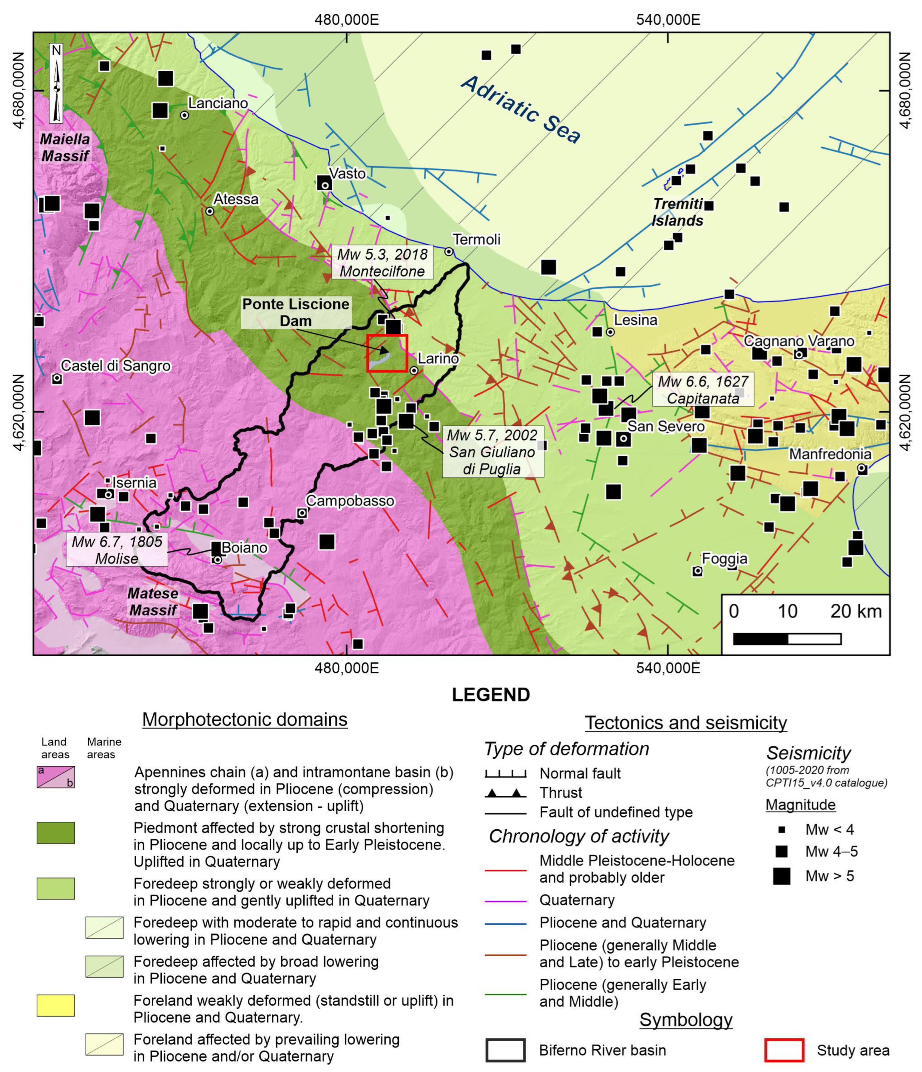
The morphostructural setting is the result of tectonic processes, regional uplift, crustal shortening, and lowering phases, spanning from Pliocene to Quaternary [64,65,66], which affect the area with different intensities and dynamics (Figure 2).
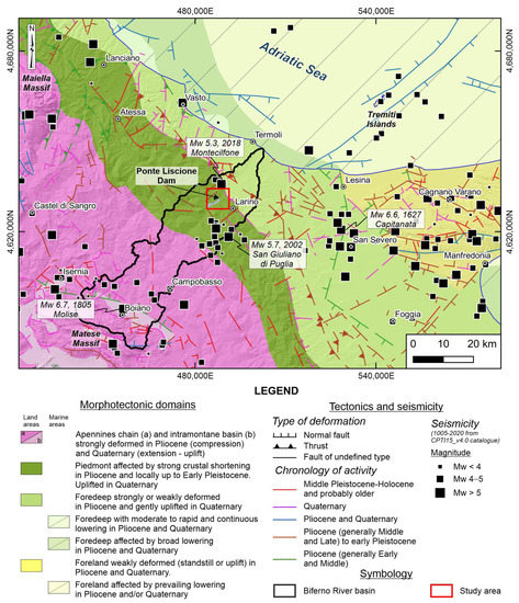
Figure 2.
Main morphotectonic domains and tectonics features (modified from [66]) of the central-southern Apennines and Periadriatic areas. Historical and recent seismicity [41] is also reported.
Moving from the inland to the offshore sectors [54,55,61], a first phase (Lower Miocene-Upper Pliocene), of a compressional nature, is characterized by the development of thin and extensive thrust sheets with an eastern vergence [54]. Strike-slip tectonics, along NNW–SSE- to E-W-oriented systems, mainly define a second phase (Upper Pliocene-Lower Pleistocene) that involves both the shallow tectonic units and the deeper ones derived from the deformation of the buried Apulian domain [61,64]. The later extensional tectonics (Middle Pleistocene-Holocene) are characterized by extensive systems of normal faults with a direction of about SW-NE and NW-SE, which have led to the definition of the present-day geological setting [37] and the creation of mainly regional tectonic structures [61]. The inner chain sectors are indeed characterized by the presence of numerous thrust and reverse faults connected to the Miocene-Pliocene compressive tectonics, as well as by normal and strike-slip faults connected to the more recent Plio-Pleistocene tectonics [54,61]. The outer foreland sectors, on the other hand, are characterized by prevalent normal and strike-slip high-angle structures, referring to the Plio-Pleistocene uplift stages of this structural domain [59,60].
From a geomorphological viewpoint, the resulting landscape is dominated by fluvial and slope processes. River incisions along main and secondary valleys and flooding are the main fluvial processes affecting the study area. In general, the drainage network shows a marked tendency to deepen, which is therefore the cause of the genesis of characteristic forms such as V-shaped valleys and zones of lateral erosion of the banks. Surface runoff, on the other hand, generates both linear and areal forms such as concentrated stream channels (gully erosion), embryonic stream zones (rill erosion), and diffuse stream areas (sheet erosion) [67].
Slope instabilities are mainly related to the combined action of various factors, e.g., tectonic elements, physical-mechanical characteristics of soils and rocks, rainfalls, dynamics of surface and underground waters, earthquakes, and actual land use [68,69,70,71]. These phenomena mainly refer to minor landforms (such as creep and/or solifluction, gullies, and mudflows) and major landslides (e.g., rotational-translational slides, earth flows, complex landslides, deep-seated gravitational slope deformations, etc.). In particular, the major landslides are distributed only rarely as isolated phenomena, and they generally occur as complex systems characterized by the displacement of masses along the slope and by the subsequent reshaping of the same by exogenous agents. These, in turn, lead to the development of new instability phenomena and to the reactivation of existing ones, finding the prerequisites for achieving new and localized instability conditions in the poor resistance characteristics of the reshaped and/or altered soils.
Historical and Recent Seismicity
Data about historical and instrumental earthquakes testify to a significant seismic activity, with earthquakes from low to high intensity (Figure 2). The present-day seismicity is characterized by earthquakes with recurrence times for Mw ≥ 6.5 events between 60 and 140 years [72]. In the area, several historical destructive earthquakes were recorded in the last centuries, e.g., 1627, Mw 6.6 Capitanata; 1805, Mw 6.7 Molise [41,73,74].
Recently, the area was affected by moderate seismicity, linked to buried outer thrust belonging to central Apennines and External Dinarides [75,76], and by remarkable earthquakes. The seismic shaking due to major events (i.e., 2002, Mw 5.7, San Giuliano di Puglia earthquake; 2018, Mw 5.3 Montecilfone) caused damage and reactivated landslides with variable characteristics [70].
3. Materials and Methods
A stepwise approach was applied to investigate the study area. It involved analyses carried out at different and appropriate scales, from the drainage basin scale (Biferno River; scale 1:50,000–1:25,000) to the local one (Ponte Liscione Dam; scale 1:10,000–1:5000). This methodological approach mainly focused on: (i) DEM-based morphometric analyses and (ii) morphotectonic and structural-geomorphological analysis.
3.1. DEM-Based Morphometric Analyses
Morphometric analyses were carried out in GIS software (QGIS version 3.22, “Białowieża”; ESRI® ArcGIS, Redlands, CA, USA version 10.6) using the 5 m DEM provided by the Molise Region (https://sciamlab.com/opendatahub/it/organization/r_molise accessed on 15 February 2023). Initially, the main hydrographic features were defined; the drainage network, as hierarchized according to Strahler [77], was automatically extracted from the DEM using the MakeStream function embedded in the Topographic Analysis Kit (TAK) (https://github.com/amforte/Topographic-Analysis-Kit accessed on 15 February 2023, [78,79]), supported and verified by means of 1:5000 topographic maps and Google Earth imagery.
According to the thematic literature [79,80,81,82,83], several morphometric indices and markers are commonly computed to define drainage network anomalies in supporting morphotectonic analysis. Starting from a geomorphological approach, and in order to define a reference unit to take into consideration in finding the main drainage network-derived indices and markers, the drainage basin scale turned out to be the most appropriate choice given the aim of the study [2,84]. Hence, an evaluation of the most helpful drainage network-derived indices (ksn) and markers (knickpoints) was carried out within the Biferno River basin.
In particular, to identify unsteadiness/disequilibrium of drainage systems, the analysis mainly focused on the calculation of the normalized channel steepness index (ksn) [85,86,87,88,89,90,91]. For a steady-state landscape, when the river incision rate is equal to the rock uplift rate, this parameter is derived from Flint’s law [92] as follows:
where S is the channel slope, ks is linked to the steepness index, A represents the upstream drainage area, and θ refers to the concavity of the river channel profile. Since the value of θ is an empirical constant variable with changes in tectonics, lithology, and climate, in accordance with numerical simulations and field observations [93,94], it normally ranges from 0.3 to 0.8, and θ = 0.5 is often used for channels in the most active orogens. In this work, the ksn is derived using a reference concavity (θref) kept fixed at 0.5 and a smoothing window of 2000 m. For the present study, the ksn map was automatically obtained from the DEM using the KsnChiBatch function embedded in the Topographic Analysis Kit (TAK) (https://github.com/amforte/Topographic-Analysis-Kit [78,79] accessed on 15 February 2023).
S = ks A−θ,
As widely acknowledged by several studies [4,90,95] dealing with the sensitivity of this index to differences in uplift rate, climate, and/or bedrock lithology, ksn can be employed as a representation of drainage system anomalies, indicative of tectonic deformation [96,97].
Since knickpoints are generally used as geomorphic markers, their identification is useful for discriminating ruptures in the stream slope and changes in natural drainage channels indicative of deformations imposed by active tectonics and/or changes in either baselevel or lithology [19,98]. For the present study, the detection of deviations from the concave-up shape of the main stream of the Biferno River was carried out. Knickpoints were automatically obtained from the DEM using the AutoKsnProfiler function (threshold value = 0.5) embedded in the Topographic Analysis Kit (TAK) (https://github.com/amforte/Topographic-Analysis-Kit accessed on 15 February 2023, [78,79]).
3.2. Morphotectonic and Structural-Geomorphological Analysis
The methodological approach proposed by [99] was recently improved upon by several works [23,51,100,101,102], and it was implemented with structural geomorphological field mapping for the purpose of the present work. The investigation of morphological field evidence of tectonics was based on stereoscopic aerial photo interpretation, verified by field analysis; it was achieved using 1:33,000 and 1:13,000 stereo pairs covering a wide time span (Flight GAI 1954, Flight Molise Region 1992 and 2002) and 1:5000 orthophoto color images (Flight Molise Region 2011). This analysis was also supported by the use of Google Earth® imagery (Google Earth, 2019) and the 5 m DEM.
The most representative geomorphological features were mapped and classified according to their arrangement in the landscape (mainly related to slopes, valleys, and hydrography). All their possible and most representative alignments along specific orientations were selected, because these could be interpreted as morphological field evidence of tectonic processes. Hence, these mapped elements can be indicative of morphotectonic processes in regions characterized by uniform climate and lithologies [31,75].
Structural-geomorphological field mapping was carried out in site-specific investigations at an appropriate scale (1:10,000–1:5000) to better define and map lithological units, superficial deposits, and elements of tectonics in the surroundings of Ponte Liscione Dam. The maps were also used to verify the type and spatial distribution of geomorphological features. In such a tectonically active region as the Biferno River valley, outcropping lithologies (e.g., clayey and marly clayey deposits) seldom maintain evidence of tectonic deformation; consequently, the investigation of peculiar geomorphological features is a useful tool in the definition of the morphotectonic context [50,75]. Field mapping was performed in accordance with the thematic literature [37,103,104,105] and following the official Italian geomorphological guidelines [106].
According to the thematic literature, fluvial terraces serve as tools to evaluate the relationships between tectonics, climate, and sea-level changes. Moreover, they can be used to derive information about tectonic deformations [107,108,109,110]. The alignments of morphological field evidence of tectonics and anomalies in the plan-altimetric distribution of fluvial terraces may be clues of tectonic activity and relative constraints in the timing of landscape development.
Within the stepwise and multiscale methodological approach, the analysis of fluvial terraces was also carried out to support morphotectonic analysis. The spatial distribution of fluvial terraces was investigated for the middle Biferno River basin by integrating data from the literature [37,57,58,63] with field surveys and expert-based stratigraphic observations. Local data, geochronological constraints, and correlation with the neighboring valleys [37,50,57,58,63,111] allowed us to define the relative age of each order of fluvial terraces. Moreover, the plan-altimetric arrangement of terrace remnants was investigated by plotting them on the longitudinal river profile [28,112]. Finally, the distribution and the timing of systems of tectonic elements were derived from the computation of fluvial terraces’ heights, gradients, orientations, and geometries associated with available morphometric features (ksn and knickpoints) [101,110].
4. Results
The resulting data led to the definition of aspects of the main morphometric and morphotectonic features of the study area, from the drainage basin scale (Biferno River) to the local scale (Ponte Liscione Dam). The arrangement and overlay of these features were useful for discriminating the possible co-presence of controls related to lithology and tectonics, for detecting anomalies in the drainage network, and for deriving insights to better investigate the landscape evolution.
4.1. Morphometric Indices and Markers
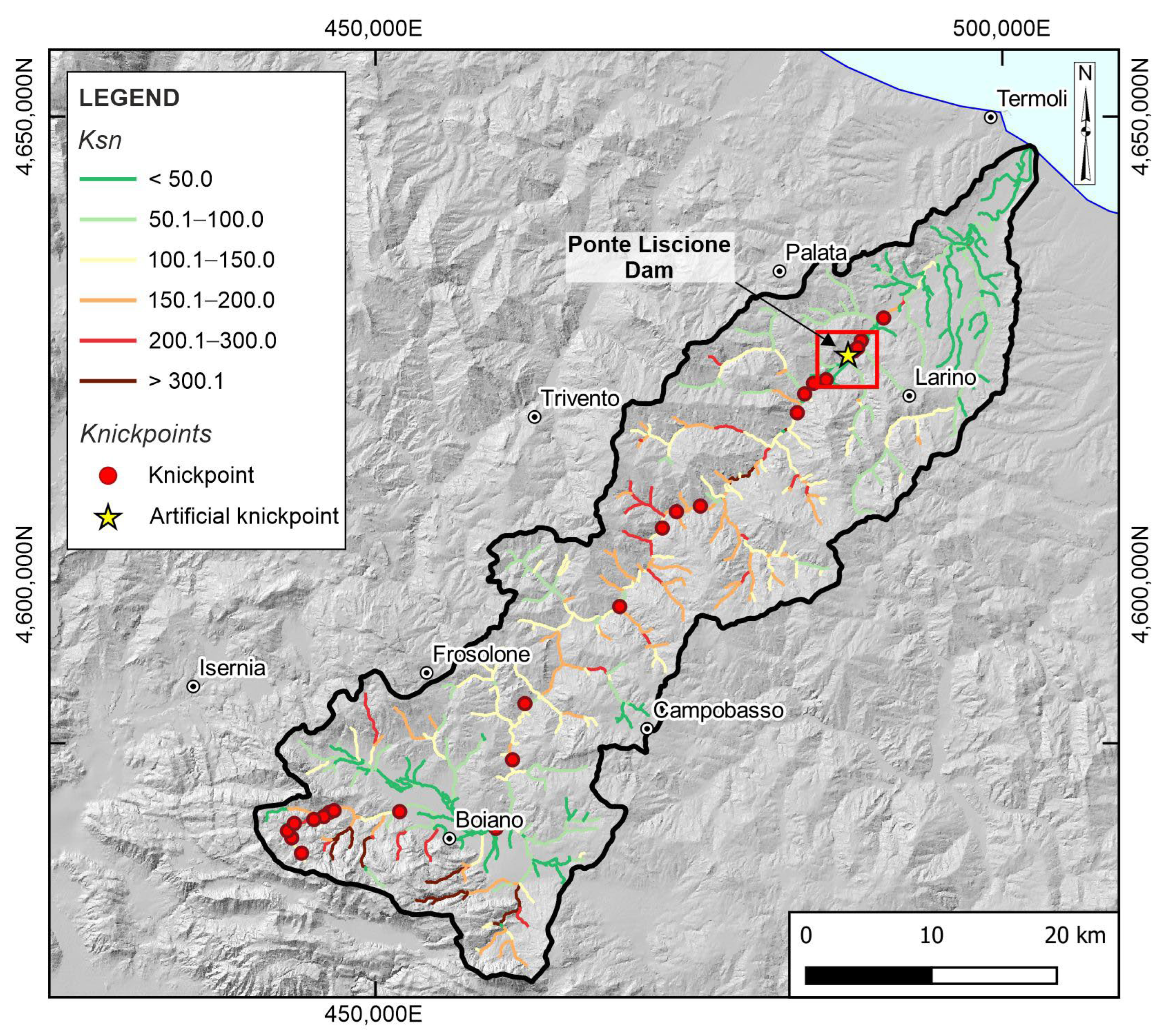
A normalized channel steepness index (ksn) map was elaborated, highlighting the spatial distribution of values and the sectors of the landscape featured by knickpoints and/or knickzones. Hence, the longitudinal spreading of knickpoints along the main stream of the Biferno River was also introduced (Figure 3).
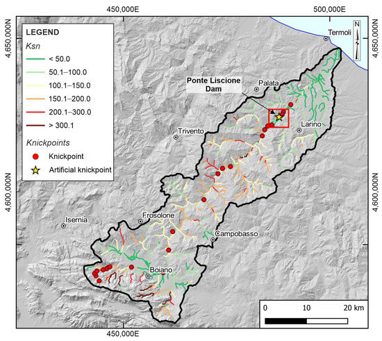
Figure 3.
Map of normalized steepness index (ksn) and spatial location of knickpoints. Normalized steepness index is calculated by considering a reference concavity of 0.5 for the whole drainage system; knickpoints are plotted only along the main trunk of the Biferno River. The red box indicates the study area.
The distribution of ksn values appears roughly heterogeneous, reflecting the complexity of the drainage network development and suggesting differences in the erosional efficiency of bedrock river incision. In the study area, the index (ksn) showed values ranging from 0 up to ~1000, which were labeled into different classes, allowing for a fair comparison of changes in ksn values regardless of significantly varying areas due to the topographic and morphological setting (i.e., low-relief areas, plain sectors, and/or steep channels in mountain front) of whole drainage basin [85,86,90].
Values of ksn are generally higher in upstream channel reaches closest to the mountain front (i.e., Matese Massif) and immediately downstream of Ponte Liscione Dam; mainly medium values are detected along the main reaches in the central sectors of the basin, in correspondence with the outcropping areas of pelitic and calcareous-marly deposits (Varicoloured Clays or Argille Varicolori Fm.) and next to the main tectonic elements, according to the literature [57,58]. Finally, the drainage network exhibits the lowest steepness near to the coastal areas and in correspondence with plain sectors next to Boiano municipality.
There is good spatial correspondence between changes in steepness index values and main drainage anomalies. A total of 25 knickpoints were identified along the main trunk of the Biferno River. First, it is possible to identify a significant anomaly in the middle Biferno River related to Ponte Liscione Dam’s artificial knickpoint (yellow star in Figure 3). Moreover, by matching the obtained longitudinal spreading of knickpoints with the available thematic literature [57,58,63,113,114,115,116], it is possible to point out different controls on these key geomorphic markers, such as rock uplift (upstream increase in ksn), tectonic controls (presence of NNW-SSE- and ~N-S-oriented tectonic elements); lithological changes/rock-type variability, and natural modifications of the main trunk (significative variability in ksn values).
4.2. Morphological Field Evidence of Tectonics
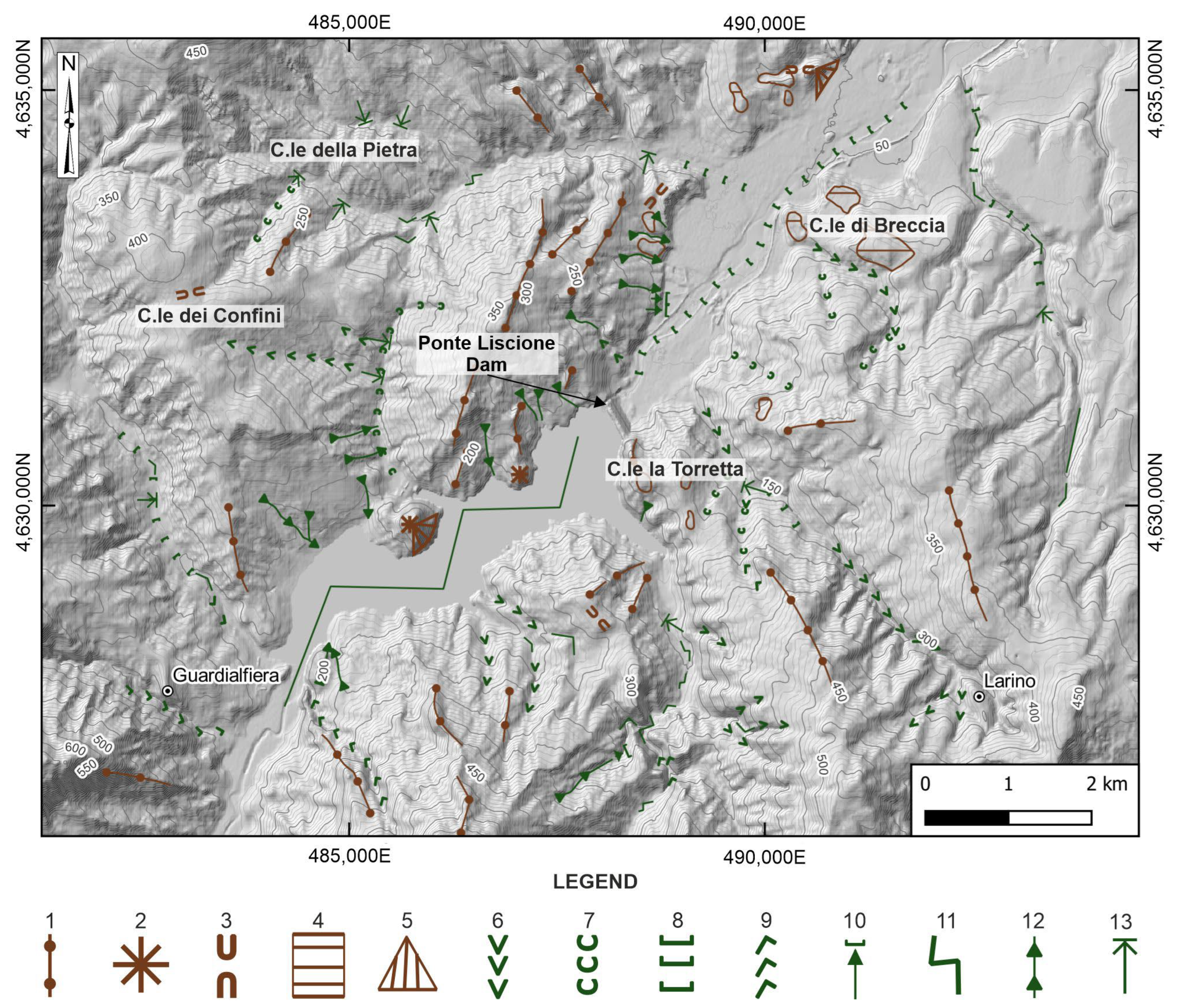
Several geomorphological features were mapped in the neighboring areas of Ponte Liscione Dam (Figure 4). All mapped elements were labeled into three main groups concerning: (i) ridges, (ii) valleys, and (iii) hydrography. Moreover, these landforms were analyzed according to their peculiar distributions and orientations. Subsequently, the alignments of significant and selected indicators (e.g., ridges, triangular facets, asymmetric and hanging valleys, river bends, and 90° confluences) were interpreted as the surface expression of tectonic elements.
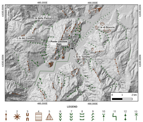
Figure 4.
Morphological field evidence of tectonics in the surroundings of Ponte Liscione Dam. Legend: (1) ridges, (2) isolated reliefs, (3) saddles, (4) structural surfaces, (5) triangular facets, (6) V-shaped valleys, (7) concave valleys, (8) flat-bottom valleys, (9) asymmetric valleys, (10) hanging valleys, (11) river bends, (12) gullies, (13) 90° confluences.
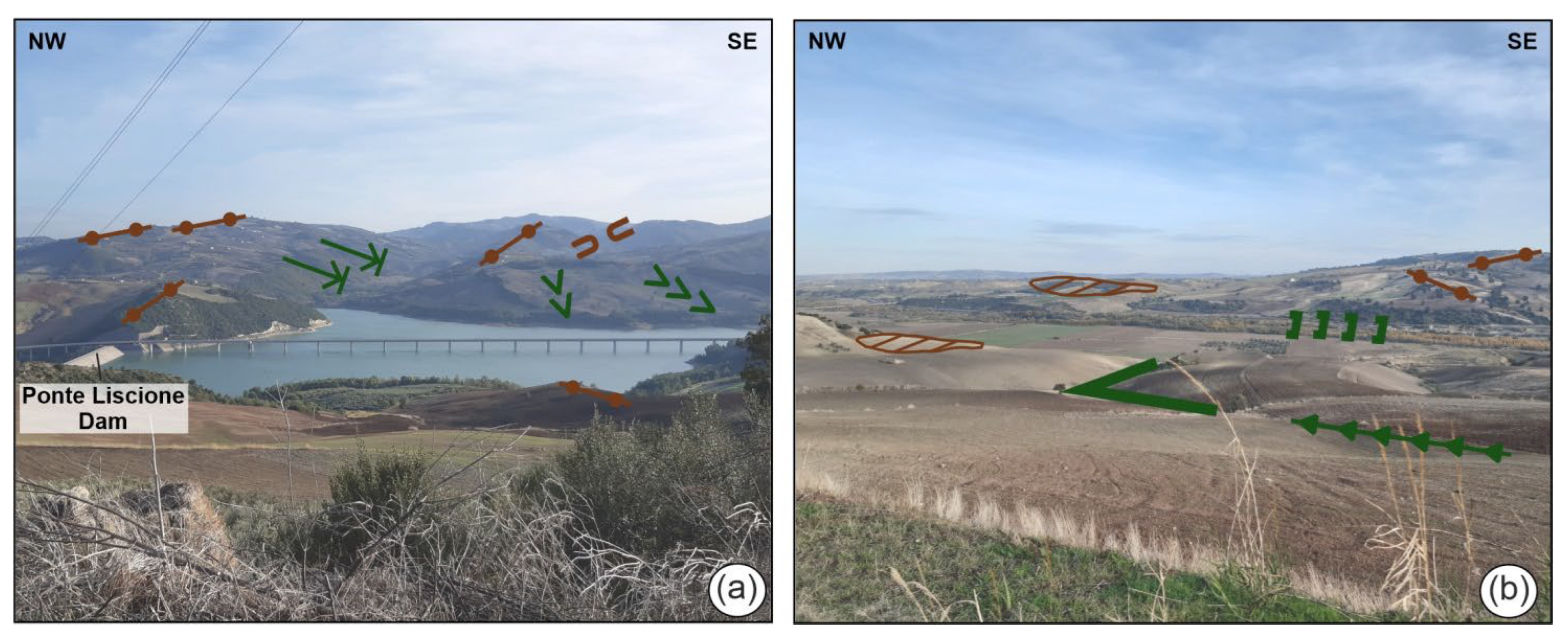
Geomorphological features related to ridges widely characterize the middle Biferno River valley. This area is dominated by ridges that are NW-SE- to ~N-S-oriented and by several saddles and isolated relief. Other straight ridges, which develop in directions varying from E-W to SW-NE, are perpendicular to the main ones and are located especially on the right side of the valley. Structural surfaces were mainly found downstream of Ponte Liscione Dam. Triangular facets are positioned in the left valley side, in the proximity of the lake and downstream of Ponte Liscione Dam (Figure 4 and Figure 5).
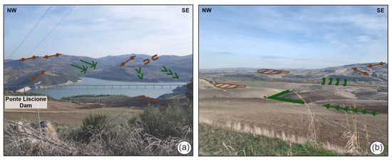
Figure 5.
Photo documentation of geomorphological features in the surroundings of Ponte Liscione Dam (for symbology, see Figure 4): (a) panoramic view of right side of the lake characterized by ridges, saddles, 90° confluences, V-shaped valleys, and river bends; (b) panoramic view of the stretch of Biferno River valley located downstream of the dam, with ridges, structural surfaces, river bends, and flat-bottom valleys.
Geomorphological features related to valleys are represented by V-shaped, concave, flat-bottom, asymmetrical, and hanging valleys. Generally, V-shaped valleys are widespread in the proximity of the lake, carved in the bedrock. Concave valleys develop on eluvial-colluvial deposits in the upper sectors. A wide flat-bottom valley characterizes the stretch of the Biferno River downstream of Ponte Liscione Dam. Asymmetrical valleys are mainly found in the SW sector, in proximity of Guardialfiera. Hanging valleys are also present (Figure 4 and Figure 5).
Geomorphological features related to hydrography largely characterize the whole study area. They are mainly represented by river bends, gullies, and 90° confluences (Figure 4 and Figure 5).
The main river bend, showing a direction from ~NNE-SSW to ~E-W, is located in correspondence with the lake (as highlighted by the interpretation of an aerial photo belonging to Flight GAI 1954). Other river bends are found along minor stream channels with alignments in SSW-NNE and NW-SE directions. Rectilinear fluvial segments and gullies are present, mainly in the left valley side with a prevalent SSW-NNE and NW-SE direction. The 90° confluences are present along the confluences between the tributaries and the main trunk, both on the right and left valley sides. Their prevalent alignments show NNW-SSE, SW-NE, and ~E-W directions.
4.3. Structural-Geomorphological Features of Ponte Liscione Dam
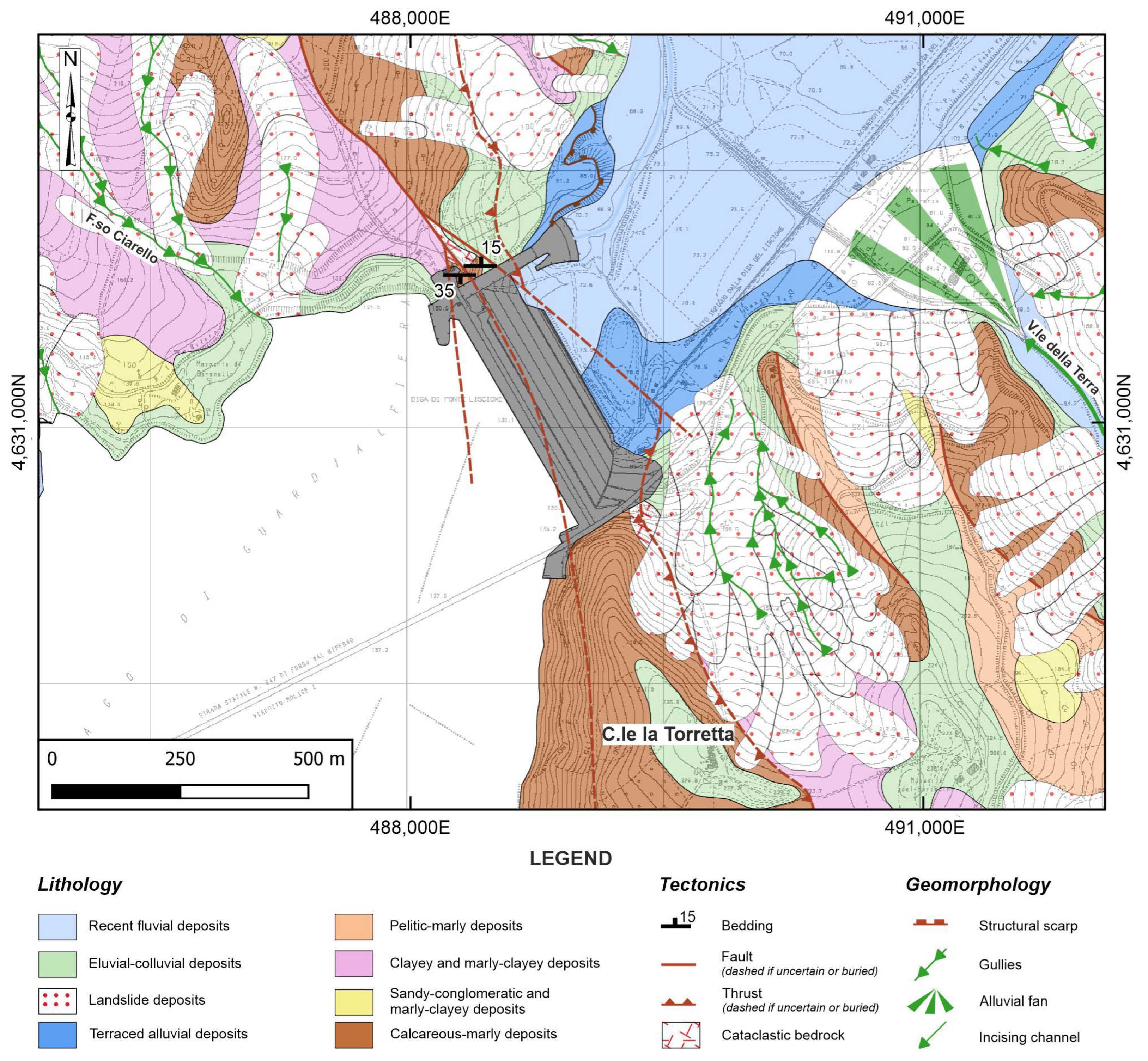
Structural-geomorphological field mapping was carried out to draw up a structural-geomorphological map, which is graphically reported in Figure 6.
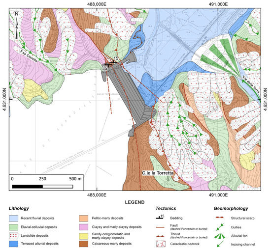
Figure 6.
Structural-geomorphological map of Ponte Liscione Dam. The gray polygon represents the artificial dam.
In the northwestern sector (F.so Ciarello), calcareous-marly deposits (Faeto Fm [57])are in contact with the clayey and marly-clayey deposits (Varicoloured Clays or Argille Varicolori Fm. [57]) through a fault to the west and a thrust to the east. Towards the east, the clayey and marly-clayey deposits (Varicoloured Clays or Argille Varicolori Fm. [57]) are covered by the more recent lithologic terms, which constitute the main morphological ridges in the area. Along the southern slope (C.le la Torretta), the fault only cuts through the calcareous-marly deposits (Faeto Fm [57]), varying its orientation until it assumes an approximately N-S trend. Towards the east, the clayey and marly-clayey deposits (Varicoloured Clays or Argille Varicolori Fm. [57]) are covered by landslide deposits. In tectonic contact on the older terms, both the calcareous-marly deposits (Faeto Fm. [57]) and the predominantly sandy-conglomeratic and marly-clayey deposits (Toppo Capuana Fm. [57]) are found.
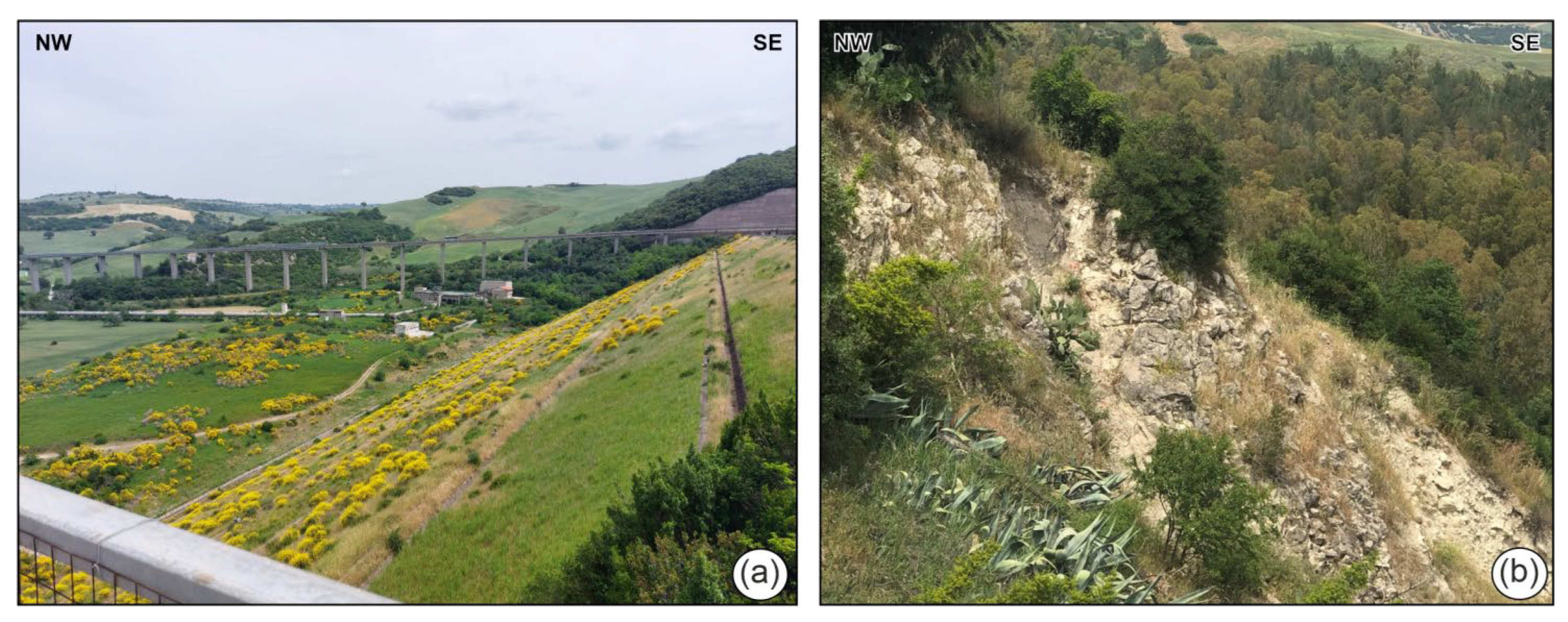
Bedrock lithologies are overlain by continental deposits (Figure 6) that are widespread and mainly represented by fluvial, eluvial-colluvial, and landslide deposits. In particular, the Biferno River valley floor is characterized by extensive alluvial plain and recent fluvial deposits (Holocene), with thicknesses ranging from approximately 10 to 15 m (Figure 7a). These deposits exhibit an extremely variable lithologic composition, ranging from gravelly-sandy to silty-clayey, and they rest on the different lithologic terms of the bedrock. In correspondence with V.le della Terra, there is a large alluvial fan connected to the sediment transport of the secondary tributary of the Biferno River on the right bank. Along the valley sides, there are patches of terraced fluvial deposits arranged on elevated surfaces of a few meters above the current valley floor, and along the slopes, there are widespread landslide and eluvial-colluvial deposits with thicknesses ranging from a few decimeters to several meters.
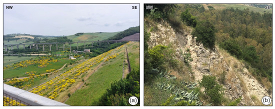
Figure 7.
(a) Panoramic view of the downstream area of Ponte Liscione Dam, showing recent fluvial deposits in the Biferno River valley floor; (b) detail of highly fractured bedrock on the left side of the dam, affected by NW-SE- to N-S-oriented tectonic elements.
At the dam site, the structural setting observed along the slopes is complicated by the presence of various tectonic elements with different styles and orientations. The bedrock lithologies are characterized by a sub-horizontal to sub-vertical stratification with orientation varying from E-W (S- or N-dipping) to N20W (SW-dipping). Furthermore, the calcareous-marly deposits are affected by N-S to N60W faults. These tectonic elements determine a moderate to high fracturing rate as determined by the presence of cataclastic bedrock mainly located around the earthfill embankment of Ponte Liscione (Figure 7b).
Geomorphological features are mainly represented by a structural scarp and gullies (Figure 6). The first, showing a direction of ~NNE-SSW, is located in the left valley side. Several gullies are present on both valley sides with a prevalent SSE-NNW and NW-SE direction.
4.4. Morphotectonic Features
The alignments and correlation of morphological field evidence of tectonics was investigated in order to contribute to the landscape reconstruction of the area and to define hints of Quaternary tectonic deformations. Taking into account the type of landforms (referring to slopes, valleys, and hydrography), as well as their distribution and preferential orientation, it was possible to outline the presence of some alignments mainly with NW-SE, E-W, and NE-SW trends.
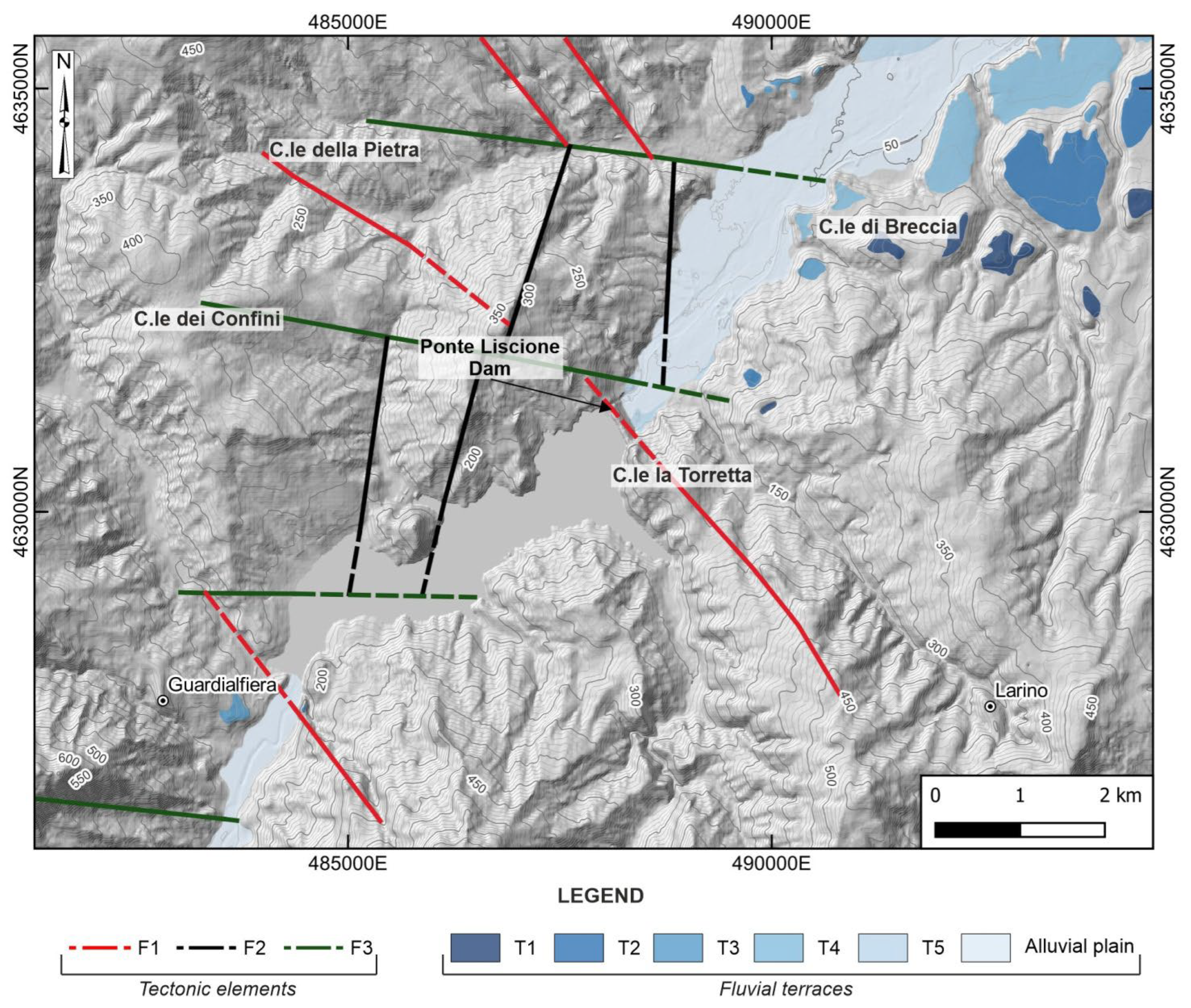
The data concerning the alignments of morphological field evidence of tectonics and the structural-geomorphological field mapping allowed us to define three different systems of tectonic elements (Figure 8):
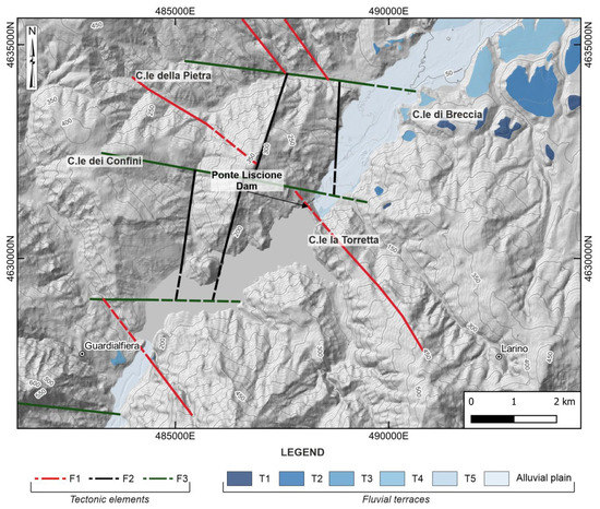
Figure 8.
Scheme of morphotectonic and fluvial terraces in the surroundings of Ponte Liscione Dam.
- F1: NW-SE-oriented;
- F2: NE-SW-oriented;
- F3: E-W- and WNW-ESE-oriented.
An analysis of the arrangement of fluvial terraces was also employed to support morphotectonic analysis, integrating data from the literature with field surveys and expert-based stratigraphic observations. In accordance with the available thematic literature [37,50,57,58,63,111], the relative age of each order of fluvial terraces, constrained in time from Middle Pleistocene to Holocene, was defined using local data, as well as comparisons and correlations with the neighboring valleys.
The Biferno River is characterized by the presence of five orders of fluvial terraced deposits (from T1 to T5). They are present on both valley sides; the oldest two orders outcrop in isolated scattered remnants, and the others move continuously towards the downstream sectors of Ponte Liscione Dam (for detail, see Figure 8). The deposits belonging to T1 (Middle Pleistocene) are mainly preserved at elevations ranging from 115 to 100 m above the present Biferno valley floor; those of the T2 terraced order (late Middle Pleistocene) hang between 110 and 75 m above the Biferno thalweg. The deposits referring to T3 (Late Middle Pleistocene) are present at heights ranging from 75 to 50 m over the present-day Biferno valley bottom. The T4 deposits (Upper Pleistocene) are found from 45 to 35 m above the Biferno thalweg. Finally, the T5 terraced order (Upper Pleistocene–Holocene) is found at elevations ranging from 20 to 5 m above the present Biferno valley floor.
5. Discussion
In tectonically active areas where discontinuities are not apparent, and more erodible lithologies seldom maintain proof of active tectonic deformation, topography and landscape features can record information about the ongoing tectonic activity. Specifically, detailed morphotectonic analyses offer valuable insights to reconstruct both passive and active tectonic control, representing important sources of information about the long-term landscape and drainage network evolution.
For this purpose, a morphometric and structural-geomorphological approach was applied to identify the main morphotectonic features in the middle Biferno River valley. A special focus was given to the neighboring areas of Ponte Liscione Dam, serving as a representative case study. This area hosts an important and strategic artificial dam and is characterized by a peculiar geological-geomorphological setting, closely connected to its location within the Molise pelagic sequences, with outcrops of non-conservative lithologies (e.g., clays and sands), which do not allow for a good in-field conservation of tectonic elements, as these are often not clearly observable.
Drainage network-derived indices (i.e., normalized channel steepness index–ksn) and markers (knickpoints) were mainly employed to discriminate ruptures and changes in natural drainage channels. In the study area, the variability in ksn values depicted homogeneous sectors of the landscape featured by unsteadiness/disequilibrium zones. Knickpoints also served as markers of landscape dynamics, showing a peculiar longitudinal spreading along the main trunk of the Biferno River. The resulting data, in close agreement with the available thematic literature [113,116], allowed us to point out different controls on these indicators, such as tectonic deformations, as well as variability in rock types, base-level changes, and/or natural modifications of the main trunk. In particular, by comparing the spatial distribution of knickpoints with available geological maps [57,66], it was possible to link some clusters of knickpoints to lithological boundaries, suggesting their relation to changes in rock resistance, with other clusters underlining the presence of inherited structures or systems of tectonic elements.
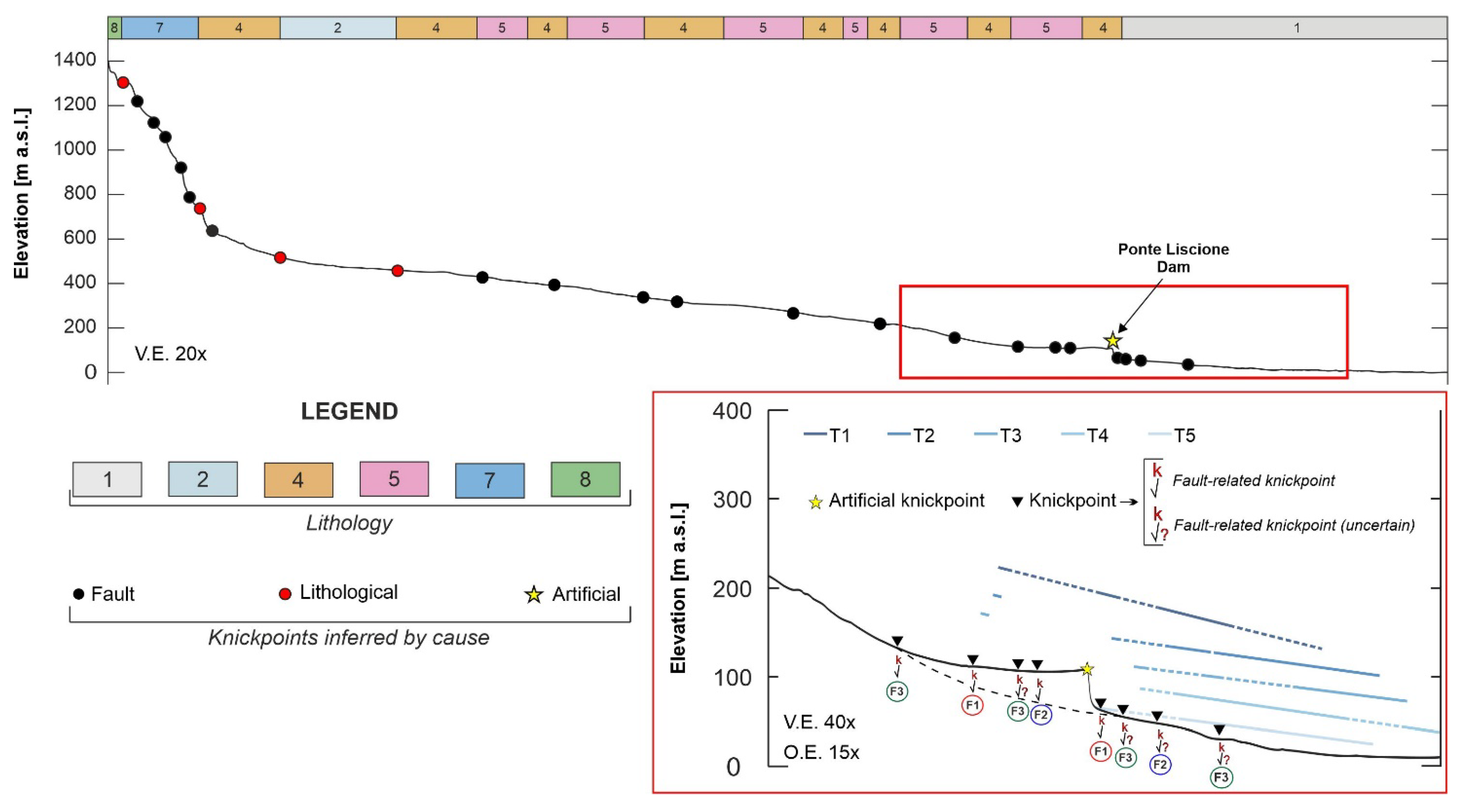
Acquired geological and structural-geomorphological data led to discriminating the response of the landscape to drainage system anomalies and tectonic deformation processes. The most representative morphological field evidence of tectonics (e.g., ridges, triangular facets, asymmetric and hanging valleys, river bends, and 90° confluences) was pointed out to stress the role of tectonics in the morphotectonic setting. Then, the peculiar alignments of these selected indicators were interpreted as the surface representation of tectonic elements. Data deriving from the alignments of morphological evidence of tectonics combined with information gathered from structural-geomorphological field mapping allowed us to define different systems of tectonic elements, with NW-SE, E-W, and NE-SW trends. As reported in several previous works (i.e., [37,117,118]) and confirmed by this study, tectonic features, mainly referring to compressive and extensional kinematics, were detected in the wider and more complex tectonic framework of the study area. Three main systems (F1, F2, and F3) characterize the middle Biferno River valley, in the surroundings of Ponte Liscione Dam. Specifically, F1 and F2 systems show NW-SE to NE-SW trends and are linked to morphostructural features, suggesting possible links to inherited deep and blind tectonic structures. The F3 system, with an E-W to WNW-ESE trend, reflects the arrangement of tectonic elements that have no superficial evidence but are currently acting in the landscape and drainage network evolution, as confirmed by recent seismic activity of the E-W-trending fault in the Molise area (i.e., Montecilfone 2018, Mw 5.3; Montagano 2023, Mw 4.6). The analysis of fluvial terraces also supported the morphotectonic analyses, enabling a tentative dating of the identified systems of tectonic elements and suggesting Quaternary tectonic deformations. In particular, specific considerations were carried out focusing on the downstream convergent geometry and the reconstructed gradient of fluvial terrace remnants (from T1 to T5) above the longitudinal profile (for details, see red box in Figure 9). In accordance with other authors [116,119], and on the basis of data resulting from this study, it was possible to deduce that the tectonic features belonging to the F3 system acted in recent times (spanning from late Middle to Upper Pleistocene), without clearly visible in-field exposures and probable strike-slip components. The F1 and F2 systems, instead, are poorly constrained to Pliocene and Middle Pleistocene, attributable to compressive and extensional kinematics related to inherited and buried structures.
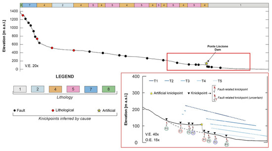
Figure 9.
The Biferno River longitudinal profile compared with its lithological configuration (for colors and numbers of lithologies, reported in the bar at the top, refer to Figure 1) and the spreading of knickpoints (for their location, see Figure 3). The red box encloses the zoomed frame of the surroundings of Ponte Liscione Dam, with the plan-altimetric arrangement of fluvial terrace remnants (from T1 to T5). The ages of these deposits are first-order terrace (T1), Middle Pleistocene; second-order terrace (T2), Middle Pleistocene; third-order terrace (T3), Late Middle Pleistocene; fourth-order terrace (T4), Upper Pleistocene; fifth-order terrace (T5), Upper Pleistocene-Holocene. The black dashed line retraces a simplified representation of the topography prior the construction of the Ponte Liscione Dam.
In order to synthesize the interpretation of the geological, geomorphological, and morphotectonic data, a generalized longitudinal profile of the Biferno River was drawn, and it is graphically reported in Figure 9. This simplified reconstruction was performed by plotting the longitudinal spreading of knickpoints along the main trunk, the lithological configuration, and the discretely preserved altimetric and spatial arrangement of fluvial terraces in the downstream sector of Ponte Liscione Dam.
The longitudinal profile shows an overall concave upward shape, with sectors featuring different steepness and morphologies. It is characterized by the occurrence of knickpoints inferred by different causes (i.e., fault, lithology, artificial). In its upstream, knickpoints are located at the boundary between the carbonate ridges of the Matese Massif to the Boiano Plain, highlighting a marked lithological control due to variability in rock types (red dot); others reflect the complex geological-structural setting due to the presence of tectonic elements/faults (black dot). In its midstream, knickpoints are mainly located in correspondence with continental deposits, pelitic-arenaceous turbiditic and clayey-marly allochthonous deposits, probably linked either to lithological variations inside these deposits or to the presence of tectonic elements/faults. In its downstream, the main deviation from the concave-up shape is located at an elevation of ~200 m a.s.l. and clearly reflects the presence of the artificial dam (yellow star in Figure 9). Moreover, other indicative markers (fault-related knickpoints) fairly match with the spatial arrangement of detected systems of tectonic elements (F1, F2, and F3) in the surroundings of Ponte Liscione Dam, even with local uncertainties due to the complexity of the area.
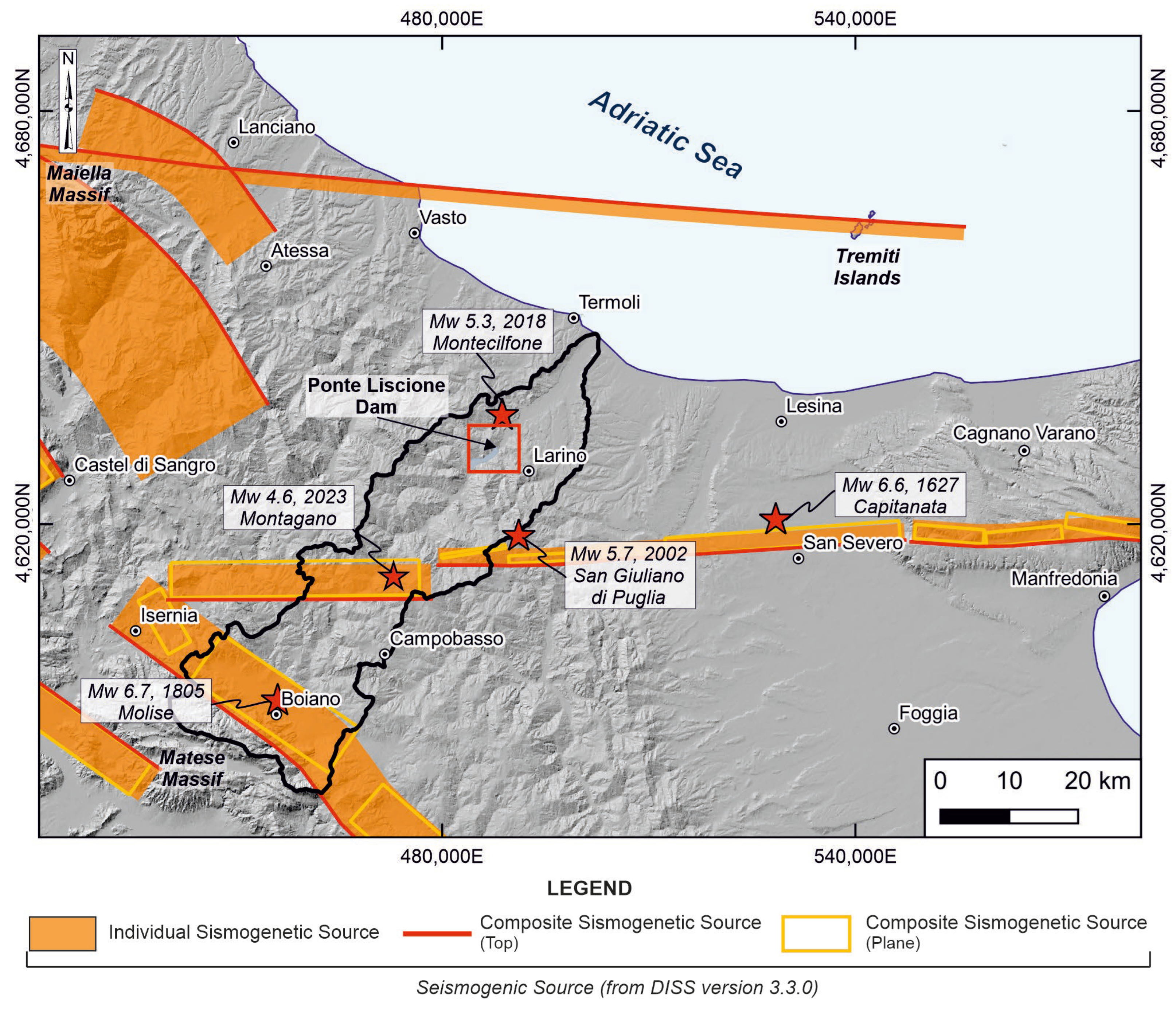
Overall findings about the morphotectonic setting in the middle Biferno River valley can be confirmed by the seismological setting (Figure 10). The area is framed within different seismogenic sources, with two main orientations and focal mechanisms. In the inner sector, close to the Matese Massif, there is a series of NW-SE-trending seismogenic sources mainly represented by normal faults, from which some strong earthquakes originated: 09 September 1349 Mw 6.7 ITCS081 Venafro [41,45]; 26 July 1805 Mw 6.7 ITCS024 Miranda-Apice [41,45]; 07 May 1984 Mw 5.8 ITCS025 Salto Lake-Ovindoli-Barrea [41,45]. However, the outer and central areas of the region, moving towards the Adriatic Sea, are characterized by E-W-trending seismogenic sources with oblique or strike-slip faults: 30 December 1456 event ITCS077 Pescolanciano-Montagano [45,120]; 30 July 1627 Mw 6.6 ITCS003 Ripabottoni-San Severo [41,45]. Recently, the 2002 San Giuliano di Puglia seismic sequence struck the eastern Molise with two Mw 5.7 mainshocks, followed by a sequence of aftershocks lasting one month. The two mainshocks were characterized by a hypocenter located at a depth of 18–22 km, along two nearly vertical strike-slip fault segments [121].
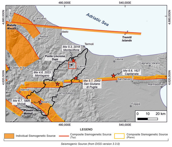
Figure 10.
Seismogenic sources [45] of the central-southern Apennines and Periadriatic areas. The red stars indicate the location of the main historical and recent earthquakes [40,41]. The red box indicates the study area.
The distribution of 1929 aftershocks shows the 15 km long E-W-trending fault system activated in 2002 [122], which is possibly associated with the Individual Seismogenic Source ITIS052-San Giuliano di Puglia and with the Individual Seismogenic Source ITIS053 Ripabottoni. Both individual seismogenic sources are part of the Ripabottoni-San Severo Composite Seismogenic Source [45].
On 16 August 2018, an area located near Montecilfone (CB) and Guardialfiera (CB) was affected by a Mw 5.3 earthquake. Its focal mechanism, like the 2002 event, indicates a right strike-slip activity along an E-W-trending fault. The seismic sequence gave rise to an aftershock sequence comprising 840 earthquakes lasting until September 2018 [70,123]. Furthermore, the surface morphotectonic evidence can be confirmed by the recent seismicity occurring after the field investigations on August 2022 that outline the recent activity of E-W-trending fault in the Molise area. In fact, on 28 March 2023, the Montagano area (CB) was hit by a Mw 4.6 earthquake showing a focal mechanism similar to the 2002 and 2018 events.
6. Conclusions
This paper presents the outcomes of the application of an approach for identifying the main morphotectonic features in the middle Biferno River valley. The study area is framed in the central-eastern sector of the Italian peninsula, showing a complex geological and tectonic setting highlighted by non-conservative lithologies (e.g., clays and sands), which hinders good in-field conservation of tectonic elements, and by recent seismicity. Moreover, the study area hosts an important water reservoir, which was created in the early seventies to supply multiple water purposes to surrounding villages (i.e., Larino, Guardialfiera, etc.).
The methodological approach, developed into an analysis carried out at different scales ranging from the drainage basin scale (Biferno River) to the local one (Ponte Liscione Dam), mainly focused on: (i) morphometric analysis of the drainage network, (ii) mapping of morphological field evidence of tectonics, and (iii) morphotectonic and structural-geomorphological analysis. The resulting data allowed us to detect the main landscape features in the surroundings of Ponte Liscione Dam, showing the response of landscapes to unsteadiness in drainage systems and to tectonic deformation processes. In particular, morphometric indices and markers were useful in discriminating ruptures and changes in natural drainage channels that are indicative of deformations imposed by active tectonics and/or changes in either baselevels or lithology. Morphological field evidence of tectonics was first labeled into three main groups, referring to ridges, valleys, and hydrography; then, the possible and most representative alignments of these features were interpreted as surface expressions of tectonic processes along specific orientations. Morphotectonic analyses, resulting from a combination of the alignments of morphological evidence of tectonics, structural-geomorphological field mapping, and the arrangement of fluvial terraces, led to the outlining of three main systems of tectonic elements (F1, F2, and F3) related to compressive and extensional kinematics. The F1 and F2 systems (NW-SE- to NE-SW-trending and constrained from Pliocene to Middle Pleistocene) are linked to morphostructural features showing both passive and active tectonic control in the landscape evolution. Finally, F3 (E-W- to WNW-ESE-trending) might reflect the arrangement of underlying tectonic elements, lacking conclusive surface evidence but able to induce drainage network reorganization, which is in agreement with the pattern of recent tectonic activity along an E-W-trending fault in the surroundings of the area. The overall findings were revealed to be in agreement with the geodynamic setting of the Periadriatic region, reflecting the seismotectonic framework outlined by historical to recent seismicity.
Finally, this work could represent a scientific tool for any geomorphological studies concerning the investigation of tectonically active areas hosting important artificial water reservoirs and dams. In particular, the methodological approach could also provide a contribution to the assessment of geological hazards, increasing the understanding of the morphotectonic framework in areas where outcropping lithologies seldom maintain evidence of tectonic features, but are widely documented to contain recent and active seismicity, such as the middle Biferno River valley.
Author Contributions
Conceptualization, M.E.D. and E.M.; methodology, V.M., G.P., M.E.D. and E.M.; validation, E.M.; investigation, V.M., G.P., M.E.D. and E.M.; resources, M.E.D., M.M., F.C. and M.R.; data curation, V.M. and M.E.D.; writing—original draft preparation, M.E.D., M.M., F.C. and M.R.; writing—review and editing, V.M., G.P. and M.E.D.; visualization, V.M., G.P., M.E.D., M.M., F.C. and M.R.; supervision, E.M.; project administration, E.M.; funding acquisition, M.E.D. and E.M. All authors have read and agreed to the published version of the manuscript.
Funding
This research was funded by the Università degli Studi “G. d’Annunzio” Chieti-Pescara funds (Enrico Miccadei fund), within the agreement between the Department of Engineering and Geology and Geoservizi S.r.l.
Data Availability Statement
Data supporting the findings of this study are available from the corresponding author upon reasonable request. Data are not publicly available due to privacy. Images employed for the study will be available online for readers.
Acknowledgments
The authors wish to thank the Cartographic Office of the Molise Region, by means of the online portal (https://sciamlab.com/opendatahub/it/organization/r_molise accessed on 7 January 2023), and the Istituto Geografico Militare Italiano (IGMI) for providing the topographic data, 5 m Digital Elevation Model (DEM), aerial photos, and orthophotos used in this study. The authors are grateful to the anonymous reviewers for their critical review of the paper and their precious suggestions, which significantly improved this manuscript.
Conflicts of Interest
The authors declare no conflict of interest.
References
- Struth, L.; Garcia-Castellanos, D.; Viaplana-Muzas, M.; Vergés, J. Drainage network dynamics and knickpoint evolution in the Ebro and Duero basins: From endorheism to exorheism. Geomorphology 2019, 327, 554–571. [Google Scholar] [CrossRef]
- Bhat, M.A.; Dar, T.; Bali, B.S. Morphotectonic analysis of Aripal Basin in the North-Western Himalayas (India): An evaluation of tectonics derived from geomorphic indices. Quat. Int. 2020, 568, 103–115. [Google Scholar] [CrossRef]
- Whittaker, A.C. How do landscapes record tectonics and climate? Lithosphere 2012, 4, 160–164. [Google Scholar] [CrossRef]
- Menier, D.; Mathew, M.; Pubellier, M.; Sapin, F.; Delcaillau, B.; Siddiqui, N.; Ramkumar, M.; Santosh, M. Landscape response to progressive tectonic and climatic forcing in NW Borneo: Implications for geological and geomorphic controls on flood hazard. Sci. Rep. 2017, 7, 457. [Google Scholar] [CrossRef] [PubMed]
- Molin, P.; Fubelli, G. Morphometric evidence of the topographic growth of the Central Apennines. Geogr. Fis. Dinam. Quat. 2005, 28, 47–61. [Google Scholar]
- Vijith, H.; Prasannakumar, V.; Pratheesh, P.; Ninu Krishnan, M.V.; Sharath Mohan, M.A. Evaluation of geomorphic expressions of bedrock Channels in the Western Ghats of southern Kerala, India, through quantitative analysis. Arab J. Geosci. 2016, 9, 393. [Google Scholar] [CrossRef]
- Bull, W.B.; McFadden, L.D. Tectonic geomorphology north and south of the Garlock fault, California. In Proceedings of the 8th Symposium in Geomorphology, Binghamton, NY, USA, 23–24 September 1977; pp. 115–138. [Google Scholar] [CrossRef]
- Ribolini, A.; Spagnolo, M. Drainage network geometry versus tectonics in the Argentera Massif (French–Italian Alps). Geomorphology 2008, 93, 253–266. [Google Scholar] [CrossRef]
- Reddy, G.P.O.; Maji, A.K.; Gajbhiye, K.S. Drainage morphometry and its influence on landform characteristics in a basaltic terrain, Central India—A remote sensing and GIS approach. Int. J. Appl. Earth Obs. Geoinf. 2004, 6, 1–16. [Google Scholar] [CrossRef]
- Marra, F.; Frepoli, A.; Gioia, D.; Schiattarella, M.; Tertulliani, A.; Bini, M.; De Luca, G.; Luppichini, M. A morphotectonic approach to the study of earthquakes in Rome. Nat. Hazards Earth Syst. Sci. 2022, 22, 2445–2457. [Google Scholar] [CrossRef]
- Saber, R.; Caglayan, A.; Isik, V. Landscape response to deformation in the Sabalan area, NW Iran: Inferred from quantitative morphological and structural analysis. Earth Environ. Sci. Trans. R. Soc. Edinb. 2022, 113, 227–252. [Google Scholar] [CrossRef]
- Kycl, P.; Rapprich, V.; Verner, K.; Novotný, J.; Hroch, T.; Mišurec, J.; Eshetu, H.; Haile, E.T.; Alemayehu, L.; Goslar, T. Tectonic control of complex slope failures in the Ameka River Valley (Lower Gibe Area, central Ethiopia): Implications for landslide formation. Geomorphology 2017, 288, 175–187. [Google Scholar] [CrossRef]
- Pazzaglia, F.J. Fluvial terraces. In Treatise on Geomorphology; Academic Press: Cambridge, MA, USA, 2013; Volume 9, pp. 379–412. [Google Scholar]
- Rodríguez-Rodríguez, L.; Antón, L.; Rodés, A.; Pallàs, R.; García-Castellanos, D.; Jiménez-Munt, I.; Struth, L.; Leanni, L.; ASTER Team. Dates and rates of endo-exorheic drainage development: Insights from fluvial terraces (Duero River, Iberian Peninsula). Glob. Planet. Change 2020, 193, 103271. [Google Scholar] [CrossRef]
- Schumm, S.A. Evolution of Drainage Systems and Slopes Amboy, New Jersey. Geol. Soc. Am. Bull. 1956, 67, 597–646. [Google Scholar] [CrossRef]
- Willett, S.D.; McCoy, S.W.; Perron, J.T.; Goren, L.; Chen, C.-Y. Dynamic Reorganization of River Basins. Science 2014, 343, 1248765. [Google Scholar] [CrossRef] [PubMed]
- Bernard, T.; Sinclair, H.D.; Gailleton, B.; Mudd, S.M.; Ford, M. Lithological control on the post-orogenic topography and erosion history of the Pyrenees. Earth Planet. Sci. Lett. 2019, 518, 53–66. [Google Scholar]
- Kirby, E.; Whipple, K.X. Expression of active tectonics in erosional landscapes. J. Struct. Geol. 2012, 44, 54–75. [Google Scholar] [CrossRef]
- Pavano, F.; Pazzaglia, F.J.; Catalano, S. Knickpoints as geomorphic markers of active tectonics: A case study from northeastern Sicily (southern Italy). Lithosphere 2016, 8, 633–648. [Google Scholar] [CrossRef]
- Cantalice, J.R.B.; da Silva Souza, W.L.; Agra Bezerra Silva, Y.J.; Guerra, S.M.S.; Araújo, A.M.; Monteiro Cavalcante, D.; Cordeiro Atanazio Cruz Silva, C.M. Bedload and Suspended Sediment of a Watershed Impacted by Dams. Eff. Sediment Transp. Hydraul. Struct. 2015, 19–40. [Google Scholar] [CrossRef]
- Ghosh, S.; Hoque, M.d.M.; Deep Saha, U.; Islam, A. Assessment of Dam-Induced Changes in Ecogeomorphological Behaviour and Fluvial Functionality in the Damodar River, West Bengal, India. AQUA—Water Infrastruct. Ecosyst. Soc. 2022, 71, 722–750. [Google Scholar] [CrossRef]
- Centamore, E.; Ciccacci, S.; Del Monte, M.; Fredi, P.; Lupia Palmieri, E. Morphological and morphometric approach to the study of the structural arrangement of northeastern Abruzzo (central Italy). Geomorphology 1996, 16, 127–137. [Google Scholar]
- Currado, C.; Fredi, P. Morphometric parameter of drainage basin and morphotectonic setting of eastern Abruzzo. Mem. Della Soc. Geol. Ital. 2000, 55, 411–420. [Google Scholar]
- Della Seta, M.; Del Monte, M.; Fredi, P.; Lupia Palmieri, E. Quantitative morphotectonic analysis as a tool for detecting deformation patterns in soft-rock terrains: A case study from the southern Marches, Italy/Analyse morphotectonique quantitative dans une province lithologique enregistrant mal les déformations: Les Marches méridionales, Italie. Géomorphologie Relief Process. Environ. 2004, 10, 267–284. [Google Scholar]
- Ferraris, F.; Firpo, M.; Pazzaglia, F.J. DEM analyses and morphotectonic interpretation: The Plio-Quaternary evolution of the eastern Ligurian Alps, Italy. Geomorphology 2012, 149–150, 27–40. [Google Scholar] [CrossRef]
- Sanakhan, A.; Solgi, A.; Sorbi, A.; Arian, M. Survey of active tectonic: The influence of river morphotectonic in Aras Basin. Arab. J. Geosci. 2020, 13, 633. [Google Scholar] [CrossRef]
- Horton, R. Erosional Development of Streams and Their Drainage Basins; Hydrophysical Approach to Quantitative Morphology. Geol. Soc. Am. Bull. 1945, 56, 275–370. [Google Scholar] [CrossRef]
- Keller, E.A.; Pinter, N. Active Tectonics: Earthquakes, Uplift, and Landscape, 2nd ed.; Prentice Hall: Upper Saddle River, NJ, USA, 2002. [Google Scholar]
- Andreani, L.; Stanek, K.P.; Gloaguen, R.; Krentz, O.; Domínguez-González, L. DEM-Based Analysis of Interactions between Tectonics and Landscapes in the Ore Mountains and Eger Rift (East Germany and NW Czech Republic). Remote Sens. 2014, 6, 7971–8001. [Google Scholar] [CrossRef]
- Knight, J.; Grab, S.W. Drainage network morphometry and evolution in the eastern Lesotho highlands, southern Africa. Quat. Int. 2018, 470, 4–17. [Google Scholar] [CrossRef]
- Gioia, D.; Schiattarella, M.; Giano, S.I. Right-angle pattern of minor fluvial networks from the ionian terraced belt, southern Italy: Passive structural control or foreland bending? Geosciences 2018, 8, 331. [Google Scholar] [CrossRef]
- Giona Bucci, M.; Schoenbohm, L.M. Tectono-Geomorphic Analysis in Low Relief, Low Tectonic Activity Areas: Case Study of the Temiskaming Region in the Western Quebec Seismic Zone (WQSZ), Eastern Canada. Remote Sens. 2022, 14, 3587. [Google Scholar] [CrossRef]
- Gupta, L.; Agrawal, N.; Dixit, J.; Dutta, S. A GIS-based assessment of active tectonics from morphometric parameters and geomorphic indices of Assam Region, India. J. Asian Earth Sci. 2022, X, 100115. [Google Scholar] [CrossRef]
- Alipoor, R.; Poorkermani, M.; Zare, M.; El Hamdouni, R. Active tectonic assessment around Rudbar Lorestan dam site, High Zagros Belt (SW of Iran). Geomorphology 2011, 128, 1–14. [Google Scholar] [CrossRef]
- Ozdemir, H.; Bird, D. Evaluation of morphometric parameters of drainage networks derived from topographic maps and DEM in point of floods. Environ. Geol. 2009, 56, 1405–1415. [Google Scholar] [CrossRef]
- Venkatesan, A.; Jothibasu, A.; Anbazhagan, S. GIS Based Quantitative Geomorphic Analysis of Fluvial System and Implications on the Effectiveness of River Basin Environmental Management. In Environmental Management of River Basin Ecosystems; Ramkumar, M., Kumaraswamy, K., Mohanraj, R., Eds.; Springer Earth System Sciences: Cham, Switzerland, 2015; pp. 201–225. [Google Scholar]
- Amato, V.; Aucelli, P.P.C.; Bracone, V.; Cesarano, M.; Rosskopf, C.M. Long-term landscape evolution of the Molise sector of the central-southern Apennines, Italy. Geol. Carphatica 2017, 68, 29–42. [Google Scholar] [CrossRef]
- Baratta, M. I Terremoti D’italia. Saggio di Storia, Geografia e Bibliografia Sismica Italiana; Fratelli Bocca Editori: Torino, Italy, 1901; 950p. [Google Scholar]
- Valensise, G.; Vannoli, P.; Burrato, P.; Fracassi, U. From Historical Seismology to seismogenic source models, 20 years on: Excerpts from the Italian experience. Tectonophysics 2020, 774, 228189. [Google Scholar] [CrossRef]
- ISIDe Working Group Italian Seismological Instrumental and Parametric Database (ISIDe). 2007. Available online: http://terremoti.ingv.it/iside (accessed on 3 April 2023).
- Rovida, A.; Locati, M.; Camassi, R.; Lolli, B.; Gasperini, P.; Antonucci, A. The Italian Earthquake Catalogue CPTI15-Version 4.0. 2022. Available online: https://emidius.mi.ingv.it/CPTI15-DBMI15/description_CPTI15_en.htm (accessed on 19 April 2022).
- Di Bucci, D.; Ravaglia, A.; Seno, S.; Toscani, G.; Fracassi, U.; Valensise, G. Seismotectonics of the southern Apennines and Adriatic foreland: Insights on active regional E-W shear zones from analogue modeling. Tectonics 2006, 25, TC4015. [Google Scholar] [CrossRef]
- Kastelic, V.; Vannoli, P.; Burrato, P.; Fracassi, U.; Tiberti, M.M.; Valensise, G. Seismogenic sources in the Adriatic Domain. Mar. Pet. Geol. 2013, 42, 191–213. [Google Scholar] [CrossRef]
- Basili, R.; Valensise, G.; Vannoli, P.; Burrato, P.; Fracassi, U.; Mariano, S.; Tiberti, M.M.; Boschi, E. The Database of Individual Seismogenic Sources (DISS), version 3: Summarising 20 years of research on Italy’s earthquake geology. Tectonophysics 2008, 453, 20–43. [Google Scholar] [CrossRef]
- DISS Working Group. Database of Individual Seismogenic Sources (DISS), Version 3.3.0.: A Compilation of Potential Sources for Earthquakes Larger than M 5.5 in Italy and Surrounding Areas. Istituto Nazionale di Geofisica e Vulcanologia. 2021. Available online: https://diss.ingv.it/diss330/dissmap.html (accessed on 24 March 2023).
- De Vincenzo, A.; Molino, A.J.; Molino, B.; Scorpio, V. Reservoir rehabilitation: The new methodological approach of Economic Environmental Defence. Int. J. Sediment Res. 2017, 32, 288–294. [Google Scholar] [CrossRef]
- Bagarani, M.; De Vincenzo, A.; Ievoli, C.; Molino, B. The Reuse of Sediments Dredged from Artificial Reservoirs for Beach Nourishment: Technical and Economic Feasibility. Sustainability 2020, 12, 6820. [Google Scholar] [CrossRef]
- Ascione, A.; Cinque, A.; Miccadei, E.; Villani, F.; Berti, C. The Plio-Quaternary uplift of the Apennine chain: New data from the analysis of topography and river valleys in Central Italy. Geomorphology 2008, 102, 105–118. [Google Scholar] [CrossRef]
- Rapisardi, L. Tratti di neotettonica al confine molisano-abruzzese. Geol. Appl. Idrogeol. 1978, 13, 223–232. [Google Scholar]
- D’Alessandro, L.; Miccadei, E.; Piacentini, T. Morphotectonic study of the lower Sangro River valley (Abruzzi, Central Italy). Geomorphology 2008, 102, 145–158. [Google Scholar] [CrossRef]
- Miccadei, E.; Piacentini, T.; Pozzo, A.D.; Corte, M.L.; Sciarra, M. Morphotectonic map of the Aventino-Lower Sangro valley (Abruzzo, Italy), scale 1:50,000. J. Maps 2013, 9, 390–409. [Google Scholar] [CrossRef]
- Gioia, D.; Gallicchio, S.; Moretti, M.; Schiattarella, M. Landscape response to tectonic and climatic forcing in the foredeep of the southern Apennines, Italy: Insights from Quaternary stratigraphy, quantitative geomorphic analysis, and denudation rate proxies. Earth Surf. Process. Landf. 2014, 39, 814–835. [Google Scholar]
- Mostardini, F.; Merlini, S. Appennino centro-meridionale. Sezioni geologiche e proposta di modello strutturale. Mem. Soc. Geol. Ital. 1986, 35, 177–202. [Google Scholar]
- Patacca, E.; Scandone, P. Geology of the Southern Apennines. Ital. J. Geosci. 2007, 7, 75–119. [Google Scholar]
- Bonardi, G.; Ciarcia, S.; Di Nocera, S.; Matano, F.; Sgrosso, I.; Torre, M. Carta delle principali unità cinematiche dell’Appennino meridionale. Nota illustrative. Ital. J. Geosci. 2009, 128, 47–60. [Google Scholar]
- Patacca, E.; Scandone, P.; Di Luzio, E.; Cavinato, G.P.; Parotto, M. Structural architecture of the central Apennines: Interpretation of the CROP 11 seismic profile from the Adriatic coast to the orographic divide. Tectonics 2008, 27, 36. [Google Scholar] [CrossRef]
- Vezzani, L.; Ghisetti, F.; Festa, A. Carta Geologica del Molise (Scala 1:100.000); Lithograph Geda: Firenze, Italy, 2004. [Google Scholar]
- Bonardi, G.; D’Argenio, B.; Perrone, V. Carta Geologica dell’Appennino Meridionale in scala 1:250.000. Mem. Soc. Geol. Ital. 1988, 41, 1341. [Google Scholar]
- Ricchetti, G.; Ciaranfi, N.; Luperto Sinni, E.; Mongelli, F.; Pieri, P. Geodinamica ed evoluzione sedimentaria e tettonica dell’avampaese apulo. Mem. Soc. Geol. Ital. 1988, 41, 57–82. [Google Scholar]
- Doglioni, C.; Mongelli, F.; Pieri, P. The Puglia uplift (SE-Italy): An anomaly in the foreland of the Apenninic subduction due to buckling of a thick continental lithosphere. Tectonics 1994, 13, 1309–1321. [Google Scholar] [CrossRef]
- Vezzani, L.; Festa, A.; Ghisetti, F. Geology and Tectonic Evolution of the Central-Southern Apennines, Italy; Geological Society of America: Boulder, CO, USA, 2010; Volume 469. [Google Scholar] [CrossRef]
- Di Bucci, D.; Corrado, S.; Naso, G.; Parotto, M.; Praturlon, A. Evoluzione Tettonica Neogenico-Quaternaria dell’Area Molisana. Ital. J. Geosci. 1999, 118, 13–30. [Google Scholar]
- Bracone, V.; Amorosi, A.; Aucelli, P.P.C.; Rosskopf, C.M.; Scarciglia, F.; Di Donato, V.; Esposito, P. The Pleistocene tectono-sedimentary evolution of the Apenninic foreland basin between Trigno and Fortore rivers (Southern Italy) through a sequence stratigraphic perspective. Basin Res. 2012, 24, 213–233. [Google Scholar] [CrossRef]
- Scrocca, D.; Tozzi, M. Tettogenesi Mio-Pliocenica dell’Appennino Molisano. Ital. J. Geosci. 1999, 118, 255–286. [Google Scholar]
- Patacca, E.; Scandone, P. Post-Tortonian mountain building in the Apennines, the role of the passive sinking of a relic lithospheric slab. In The Lithosphere in Italy—Advances in Earth Science Research—A Mid-term Conference Convened by the Italian National Committee for the International Lithosphere Program and Sponsored by the Accademia Nazionale Dei Lincei and the Consiglio Nazionale Delle Ricerche; Boriani, A., Bonafede, M., Piccardo, G.B., Vai, G.B., Eds.; Accademia Nazionale dei Lincei: Rome, Italy, 1989; Volume 80, pp. 157–176. [Google Scholar]
- C.N.R. Neotectonic Map of Italy (Scale 1:500.000). In Progetto Finalizzato Geodinamica; Ambrosetti, P., Bartolini, C., Bosi, C., Carraro, F., Ciaranfi, N., Panizza, M., Papani, G., Vezzani, L., Zanferrari, A., Eds.; Consiglio Nazionale delle Ricerche (CNR): Rome, Italy, 1987. [Google Scholar]
- Rosskopf, C.M.; Scorpio, V. Geomorphologic map of the Biferno River valley floor system (Molise, southern Italy). J. Maps 2013, 9, 106–114. [Google Scholar] [CrossRef]
- APAT. Rapporto sulle frane in Italia: Il Progetto IFFI. Metodologia, risultati e rapporti regionali. APAT Rep. 2007, 78, 681. [Google Scholar]
- Pisano, L.; Zumpano, V.; Aucelli, P.P.C.; Parise, M.; Rosskopf, C.M. Landslide susceptibility zonation at the regional scale: The Molise case study (Italy). Rend. Online Della Soc. Geol. Ital. 2016, 41, 183–186. [Google Scholar] [CrossRef]
- Martino, S.; Antinielli, B.; Bozzano, F.; Caprari, P.; Discenza, M.E.; Esposito, C.; Fiorucci, M.; Iannucci, R.; Marmoni, G.M.; Schilirò, L. Landslides triggered after the 16 August 2018 Mw 5.1 Molise earthquake (Italy) by a combination of intense rainfalls and seismic shaking. Landslides 2020, 17, 1177–1190. [Google Scholar] [CrossRef]
- Martino, S.; Marmoni, G.M.; Fiorucci, M.; Ceci, A.F.; Discenza, M.E.; Rouhi, J.; Tedoradze, D. Role of antecedent rainfall in the earthquake-triggered shallow landslides involving unsaturated slope covers. Appl. Sci. 2022, 12, 2917. [Google Scholar] [CrossRef]
- Jenny, S.; Goes, S.; Giardini, D.; Kahle, H.G. Seismic potential of southern Italy. Tectonophysics 2006, 415, 81–101. [Google Scholar] [CrossRef]
- Guidoboni, E.; Ferrari, G.; Tarabusi, G.; Sgattoni, G.; Comastri, A.; Mariotti, D.; Ciuccarelli, C.; Bianchi, M.G.; Valensise, G. CFTI5Med, the new release of the catalogue of strong earthquakes in Italy and in the Mediterranean area. Sci. Data 2019, 6, 80. [Google Scholar] [CrossRef]
- Miccolis, S.; Filippucci, M.; de Lorenzo, S.; Frepoli, A.; Pierri, P.; Tallarico, A. Seismogenic Structure Orientation and Stress Field of the Gargano Promontory (Southern Italy) From Microseismicity Analysis. Front. Earth Sci. 2021, 9, 589332. [Google Scholar] [CrossRef]
- Miccadei, E.; Carabella, C.; Paglia, G. Morphoneotectonics of the Abruzzo Periadriatic Area (Central Italy): Morphometric Analysis and Morphological Evidence of Tectonics Features. Geosciences 2021, 11, 397. [Google Scholar] [CrossRef]
- Di Stefano, R.; Ciaccio, M.G.; Baccheschi, P.; Zhao, D. The Adriatic Thrust Fault of the 2021 Seismic Sequence Estimated from Accurate Earthquake Locations Using sP Depth Phases. Bull. Seismol. Soc. Am. 2022, 113, 480–493. [Google Scholar] [CrossRef]
- Strahler, A.N. Quantitative classification of watershed geomorphology. Trans. Am. Geophys. Union 1957, 38, 913–920. [Google Scholar] [CrossRef]
- Forte, A.M.; Whipple, K.X. Short communication: The Topographic Analysis Kit (TAK) for TopoToolbox. Earth Surf. Dyn. 2019, 7, 87–95. [Google Scholar] [CrossRef]
- Forte, A.M. Topographic-Analysis-Kit, (v1.0.2). Zenodo. 2019. Available online: https://zenodo.org/record/2536565/export/hx (accessed on 10 February 2023).
- Hack, J.T. Stream-Profile Analysis and Stream-Gradient Index. J. Res. U.S. Geol. Surv. 1973, 1, 421–429. [Google Scholar]
- Valkanou, N.; Karymbalis, E.; Papanastassiou, D.; Soldati, M.; Chalkias, C.; Gaki-Papanastassiou, K. Μorphometric Analysis for the Assessment of Relative Tectonic Activity in Evia Island, Greece. Geosciences 2020, 10, 264. [Google Scholar] [CrossRef]
- Buczek, K.; Gòrnik, M. Evaluation of tectonic activity using morphometric indices: Case study of the Tatra Mts. (Western Carpathians, Poland). Environ. Earth Sci. 2020, 79, 176. [Google Scholar] [CrossRef]
- Pavano, F.; Romagnoli, G.; Tortorici, G.; Catalano, S. Morphometric evidences of recent tectonic deformation along the southeast-ern margin of the Hyblean Plateau (SE-Sicily, Italy). Geomorphology 2019, 342, 1–19. [Google Scholar] [CrossRef]
- Romshoo, S.A.; Bhat, S.A.; Rashid, I. Geoinformatics for assessing the morphometric control on hydrological response at watershed scale in the upper Indus Basin. J. Earth Syst. Sci. 2012, 121, 659–686. [Google Scholar] [CrossRef]
- Wobus, C.; Whipple, K.X.; Kirby, E.; Snyder, N.; Johnson, J.; Spyropolou, K.; Crosby, B.; Sheehan, D. Tectonics from topography: Procedures, promise, and pitfalls. Spec. Pap. Geol. Soc. Am. 2006, 398, 55–74. [Google Scholar] [CrossRef]
- Smith, A.G.; Fox, M.; Schwanghart, W.; Carter, A. Comparing methods for calculating channel steepness index. Earth-Sci. Rev. 2022, 227, 103970. [Google Scholar] [CrossRef]
- Siddiqui, S.; Castaldini, D.; Soldati, M. DEM-based drainage network analysis using steepness and Hack SL indices to identify areas of differential uplift in Emilia–Romagna Apennines, northern Italy. Arab. J. Geosci. 2017, 10, 3. [Google Scholar] [CrossRef]
- Cyr, A.J.; Granger, D.; Olivetti, V.; Moli, P. Quantifying rock uplift rates using channel steepness and cosmogenic nuclide–determined erosion rates: Examples from northern and southern Italy. Lithosphere 2010, 2, 188–198. [Google Scholar] [CrossRef]
- Kirby, E.; Whipple, K. Quantifying differential rock-uplift rates via stream profile analysis. Geology 2001, 29, 415–418. [Google Scholar] [CrossRef]
- Castillo, M.; Muñoz-Salinas, E.; Ferrari, L. Response of a landscape to tectonics using channel steepness indices (ksn) and OSL: A case of study from the Jalisco Block, Western Mexico. Geomorphology 2014, 221, 204–214. [Google Scholar] [CrossRef]
- Whittaker, A.C.; Boulton, S.J. Tectonic and climatic controls on knickpoint retreat rates and landscape response times. J. Geophys. Res. Earth Surf. 2012, 117, 19. [Google Scholar] [CrossRef]
- Flint, J.J. Stream gradient as a function of order, magnitude, and discharge. Water Resour. Res. 1974, 10, 969–973. [Google Scholar] [CrossRef]
- Whipple, K.X. Bedrock Rivers and the Geomorphology of Active Orogens. Annu. Rev. Earth Planet. Sci. 2004, 32, 151–185. [Google Scholar] [CrossRef]
- Mudd, S.M.; Clubb, F.J.; Gailleton, B.; Hurst, M.D. How concave are river channels? Earth Surf. Dynam. 2018, 6, 505–523. [Google Scholar] [CrossRef]
- Boulton, S.J. Geomorphic Response to Differential Uplift: River Long Profiles and Knickpoints from Guadalcanal and Makira (Solomon Islands). Front. Earth Sci. 2020, 8, 23. [Google Scholar] [CrossRef]
- Spagnolo, M.; Pazzaglia, F.J. Testing the geological influences on the evolution of river profiles: A case from the northern Apennines (Italy). Suppl. Geogr. Fis. E Din. Quat. 2005, 28, 103–113. [Google Scholar]
- Roe, G.H.; Montgomery, D.R.; Hallet, B. Effects of orographic precipitation variations on the concavity of steady-state river profiles. Geology 2002, 30, 143–146. [Google Scholar] [CrossRef]
- Queiroz, G.L.; Salamuni, E.; Nascimento, E.R. Knickpoint finder: A software tool that improves neotectonic analysis. Comput. Geosci. 2015, 76, 80–87. [Google Scholar] [CrossRef]
- Ambrosetti, P.; Bonadonna, F.P.; Bosi, C.; Carraro, F.; Cita, B.M.; Giglia, G.; Manetti, P.; Martinis, B.; Merlo, C.; Panizza, M.; et al. Proposta di un Progetto Operativo per L’elaborazione della Carta Neotettonica D’italia; CNR-Progetto Finalizzato Geodinamica: Rome, Italy, 1976; pp. 1–49. [Google Scholar]
- Carabella, C.; Buccolini, M.; Galli, L.; Miccadei, E.; Paglia, G.; Piacentini, T. Geomorphological analysis of drainage changes in the NE Apennines piedmont area: The case of the middle Tavo River bend (Abruzzo, Central Italy). J. Maps 2020, 16, 222–235. [Google Scholar] [CrossRef]
- Miccadei, E.; Carabella, C.; Paglia, G.; Piacentini, T. Paleo-drainage network, morphotectonics, and fluvial terraces: Clues from the verde stream in the middle Sangro river (central italy). Geosciences 2018, 8, 337. [Google Scholar] [CrossRef]
- Piacentini, T.; Miccadei, E. The role of drainage systems and intermontane basins in the Quaternary landscape of the Central Apennines chain (Italy). Rend. Lincei 2014, 25 (Suppl. 2), 139–150. [Google Scholar] [CrossRef]
- Chelli, A.; Segadelli, S.; Vescovi, P.; Tellini, C. Large-scale geomorphological mapping as a tool to detect structural features: The case of Mt. Prinzera ophiolite rock mass (Northern Apennines, Italy). J. Maps 2016, 12, 770–776. [Google Scholar] [CrossRef]
- Demurtas, V.; Orrù, P.E.; Deiana, G. Evolution of Deep-Seated Gravitational Slope Deformations in Relation with Uplift and Fluvial Capture Processes in Central Eastern Sardinia (Italy). Land 2021, 10, 1193. [Google Scholar] [CrossRef]
- Miccadei, E.; Piacentini, T.; Buccolini, M. Long-term geomorphological evolution in the Abruzzo area, Central Italy: Twenty years of research. Geol. Carpathica 2017, 68, 19–28. [Google Scholar] [CrossRef]
- Campobasso, C.; Carton, A.; Chelli, A.; D’orefice, M.; Dramis, F.; Graciotti, R.; Guida, D.; Pambianchi, G.; Peduto, F.; Pellegrini, L. Aggiornamento ed integrazioni delle linee guida della Carta Geomorfologica d’Italia alla scala 1:50.000. In Quaderni Serie III; Servizio Geologico d’Italia: Rome, Italy, 2021; Volume 13. [Google Scholar]
- Maddy, D. Uplift-driven valley incision and river terrace formation in southern England. J. Quat. Sci. 1997, 12, 539–545. [Google Scholar] [CrossRef]
- Kiden, P.; Törnqvist, T.E. Can river terrace flights be used to quantify Quaternary tectonic uplift rates? J. Quat. Sci. 1998, 13, 573–575. [Google Scholar] [CrossRef]
- Lavé, J.; Avouac, J.P. Active folding of fluvial terraces across the Siwaliks Hills, Himalayas of central Nepal. J. Geophys. Res. Solid Earth 2000, 105, 5735–5770. [Google Scholar] [CrossRef]
- Wegmann, K.W.; Pazzaglia, F.J. Late Quaternary fluvial terraces of the Romagna and Marche Apennines, Italy: Climatic, lithologic, and tectonic controls on terrace genesis in an active orogen. Quat. Sci. Rev. 2009, 28, 137–165. [Google Scholar] [CrossRef]
- Piacentini, T.; Mascioli, F.; Miccadei, E. Successioni del Quaternario continentale. In Note Illustrative del Foglio 372 “Vasto” della Carta Geologica D’italia alla Scala 1: 50.000; Servizio Geologico d’Italia, ISPRA: Roma, Italy, 2012; pp. 55–69. [Google Scholar]
- Merritts, D.J.; Vincent, K.R.; Wohl, E.E. Long river profiles, tectonism, and eustasy: A guide to interpreting fluvial terraces. J. Geophys. Res. Solid Earth 2004, 99, 31–50. [Google Scholar] [CrossRef]
- Valente, E. Long-Term Morphotectonic Evolution of the Southern Apennines. Ph.D. Thesis, Università degli Studi di Napoli “Federico II”, Napoli, Italy, 2009; 224p. [Google Scholar]
- Bracone, V. Studio Geologico-Stratigrafico e Geomorfologico nel Settore Costiero Compreso tra il Fiume Trigno ed il Fiume Fortore. Ph.D. Thesis, Università degli Studi del Molise, Campobasso, Italy, 2009; 149p. [Google Scholar]
- Kruse, S.; Royden, L. Bending and unbending of an elastic lithosphere: The Cenozoic history of the Apennine and Dinaride foredeep basins. Tectonics 1994, 13, 278–302. [Google Scholar] [CrossRef]
- Ferrarini, F.; Arrowsmith, J.R.; Brozzetti, F.; de Nardis, R.; Cirillo, D.; Whipple, K.X.; Lavecchia, G. Late Quaternary Tectonics along the Peri-Adriatic Sector of the Apenninic Chain (Central-Southern Italy): Inspecting Active Shortening through Topographic Relief and Fluvial Network Analyses. Lithosphere 2021, 2021, 7866617. [Google Scholar] [CrossRef]
- Cello, G.; Martini, N.; Paltrinieri, W.; Tortorici, L. Structural styles in the frontal zones of the southern Apennines, Italy: An example from the Molise district. Tectonics 1989, 8, 753–768. [Google Scholar]
- Galeandro, A.; Doglioni, A.; Guerricchio, A.; Simeone, V. Hydraulic stream network conditioning by a tectonically induced, giant, deep-seated landslide along the front of the Apennine chain (south Italy). Nat. Hazards Earth Syst. Sci. 2013, 13, 1283–1329. [Google Scholar] [CrossRef]
- Corrado, S.; Di Bucci, D.; Naso, G.; Butler, R.W.H. Thrusting and strike-slip tectonics in the Alto Molise region (Italy): Implications for the Neogene-Quaternary evolution of the Central Apennine orogenic system. J. Geol. Soc. Lond. 1997, 154, 679–688. [Google Scholar] [CrossRef]
- Fracassi, U.; Valensise, G. Unveiling the sources of the catastrophic 1456 multiple earthquake: Hints to an unexplored tectonic mechanism in southern Italy. Bull. Seismol. Soc. Am. 2017, 97, 725–748. [Google Scholar] [CrossRef]
- Latorre, D.; De Gori, P.; Chiarabba, C.; Amato, A.; Virieux, J.; Monfret, T. Three-dimensional kinematic depth migration of converted waves: Application to the 2002 Molise aftershock sequence (southern Italy). Geophys. Prospect. 2008, 56, 587–600. [Google Scholar] [CrossRef]
- Chiarabba, C.; De Gori, P.; Chiaraluce, L.; Bordoni, P.; Cattaneo, M.; De Martin, M.; Frepoli, A.; Michelini, A.; Monachesi, A.; Moretti, M.; et al. Mainshocks and aftershocks of the 2002 Molise seismic sequence, southern Italy. J. Seismol. 2005, 9, 487–494. [Google Scholar] [CrossRef]
- Moretti, M.; Margheriti, L.; Govoni, A.; Marchetti, A.; Ointore, S.; Carrannante, S.; D’Alema, E.; De Gori, P.; Piccinini, D.; valoroso, L.; et al. L’emergenza sismica in Molise (Agosto 2018). Implementazione della rete sismica di emergenza SISMIKO e condivisione dei dati. Rapp. Tec. INGV 2020, 418, 1–32. [Google Scholar]
Disclaimer/Publisher’s Note: The statements, opinions and data contained in all publications are solely those of the individual author(s) and contributor(s) and not of MDPI and/or the editor(s). MDPI and/or the editor(s) disclaim responsibility for any injury to people or property resulting from any ideas, methods, instructions or products referred to in the content. |
© 2023 by the authors. Licensee MDPI, Basel, Switzerland. This article is an open access article distributed under the terms and conditions of the Creative Commons Attribution (CC BY) license (https://creativecommons.org/licenses/by/4.0/).

