Article

Micromorphological Analysis of Archaeological Abenaki Pit Features from the Fort Odanak Site (CaFe-7), Québec, Canada

1
Department of Historical Sciences and Centre de Recherche Cultures–Arts–Sociétés (CELAT), Pavillon De Koninck, Université Laval, Quebec, QC G1V 0A6, Canada
2
Department of Geography and Centre D’études Nordiques, Université Laval, Quebec, QC G1V 0A6, Canada
*
Author to whom correspondence should be addressed.
Geosciences 2022, 12(12), 437; https://doi.org/10.3390/geosciences12120437
Submission received: 21 October 2022 / Revised: 22 November 2022 / Accepted: 24 November 2022 / Published: 26 November 2022
(This article belongs to the Special Issue Arctic Geoarchaeology and Environmental Archaeology)

Abstract

:
Built in the early 18th century on the banks of the Saint-François River (Quebec, QC, Canada), the fortified Jesuit mission of Saint-François-de-Sales was an important Abenaki centre during the colonial period. Between 2010 and 2021, archaeological excavations conducted by the Waban-Aki Nation led to the discovery of the mission’s remains at the Fort Odanak site (CaFe-7) in the historical centre of Odanak (Quebec, QC, Canada), and revealed numerous pit features likely used for storage or refuse disposal. A sedimentological and micromorphological investigation was undertaken in two areas of the site to identify the function and use of four pit features and to clarify site formation and evolution over time. Our study indicates that all pit features were used as refuse facilities prior to abandonment, but two of them were possibly used for storage. Chronological (14C) results indicate that Indigenous people frequented the site during the 16th century, before the establishment of the Jesuit mission, and that an initial domestic Abenaki occupation occurred during the second half of the 18th century in one of the sampled sectors. The use of traditional pit features by the Abenaki of Odanak seems to have persisted into the late 19th century.

1. Introduction

The Abenaki (W8banakiak, the symbol « 8 » represents a nasal « o » in the Abenaki language) or “People of the Dawn Land” are an Algonquian people that originally occupied a vast territory extending from New England (USA) to the Maritime provinces (Canada), covering the present-day state of Maine and portions of Vermont, New Hampshire and the province of Québec [1]. They were historically divided into several groups distributed around the major river drainage basins of the Ndakina, their ancestral territory. These groups followed a semi-nomadic subsistence pattern combining hunting, gathering and horticultural activities [2,3,4]. During the 17th and 18th centuries, the history of the Abenaki became increasingly intertwined with that of the French and English colonies, leading to population movements and new cultural configurations within communities [2,4,5,6]. This period saw the progressive sedentarization of the Abenaki, as they congregated around Jesuit missions, resulting in a permanent transformation of their traditional way of life and their relationships to local resources [2,7]. Until recently, the bulk of our information about the Abenaki people of this period came from contemporary colonial archival sources. Intensification of archaeological research conducted across Ndakina thus offers new possibilities for understanding the change and continuity in the Abenaki way of life and cultural practices during the Historic period. In contrast to the Algonquian and Iroquoian archaeological records in the Great Lakes region, little is yet known about Late Pre-Contact and Historic Abenaki sites in the Northeast. Archaeological excavations undertaken at important Abenaki settlement sites such as Norridgewock in Maine [3], Odanak in Quebec [2], Fort Hill (Squackhead) in New Hampshire [8], and along the Missisquoi River in Vermont [3], have gradually provided relevant information. Because of its historical importance both as an Abenaki stronghold and a Jesuit Mission, and its continuous occupation since 1715, the Fort Odanak site is an essential source of information on the evolution of Abenaki subsistence practices, settlement patterns, and domestic activities during the 18th and 19th centuries [2,9].

1.1. Archaeological Pit Features at the Fort Odanak Site

Between 2010 and 2021 archaeological excavations, conducted by the Waban-Aki Nation at Odanak (QC, Canada), led to the discovery of the remains of the 18th century Saint-François-de-Sales Jesuit mission, located in the village between the presbytery and the museum (Figure 1) [10,11,12,13]. Evidence of traditional Abenaki dwellings represented by hearths, pits, and post holes along with numerous artifacts that provided valuable information about the daily lives and practices of the mission’s occupants during the 18th and 19th centuries were recovered. Over a hundred pit features of various sizes, many of which were rich in artifacts and preserved organic remains such as bones and seeds were found near or within the excavated houses [14]. Features discovered during the first archaeological campaigns on the site were classified according to their artifact, ecofact and charcoal content in order to demarcate activity areas on the site [10,11,12,13], but thorough analysis of their sedimentary content was not undertaken. Sediment samples were collected during the 2018 excavation campaign from four pit features situated in areas 12A and 12F of the site, as part of a doctoral project (Figure 1). The aim of this research is to conduct a multidisciplinary study of historical Abenaki pit features using a geoarchaeological approach, in order to improve our understanding of their use and to better understand the spatial organization of the site.

1.2. Pre-Contact and Historic Indigenous Pit Features in the Northeast

By the Late Woodland Period (A.D. 1000–1500), pit features were common domestic features on Indigenous sites in the Northeast [3,15,16,17]. They were used mainly as storage and refuse disposal facilities, but could also be used for a variety of activities such as food processing and cooking (earth ovens, corn-parching trenches, wild rice threshing pits, etc.), food storage (storage pits, cache pits), hide tanning and colouring (smudge pits), craft activities, ceremonial practices, and burials [3,15,16,18,19,20]. Archaeological pit features thus provide important insights into the daily lives of Indigenous populations in the past [16,21,22].
Pits that were used for storage were described in detail by European explorers as large holes dug into well-drained soils, and lined with bark or grass (mats and hides are also mentioned) for protection against vermin and moisture [3,17,22,23,24,25,26,27,28,29]. Food supplies (e.g., corn, pumpkins, nuts, dried berries, dried meat and fish, wild rice, etc.) and medicinal herbs were stored in containers made of bark, ceramic, wood or animal skins [15,19,21,22,30]. Additional layers of bark or hay were piled on top of the stored goods, and the pits were then covered with earth and various materials (e.g., branches, leaves) to conceal them from animals and human intruders [19,22,28]. Archaeologically identified storage pits are generally large (between 0.60 and 2 m in diameter) and deep (from 0.30 m to 2 m in depth) with either a flat-bottomed cylindrical shape (or U-shaped profile) or a bell-shaped profile [3,15,16,19,21,22,30,31]. On horticultural village sites, storage pits have been found mainly inside houses, in the corners and along the walls (under longhouse bunklines). They are also found outside, near the ends of longhouses and around village perimeters (near the enclosing palisades) [16,32].
References to the use of refuse pits are scarce in historical accounts [16,22] (pp. 53–54) although these features are frequently documented at archaeological settlement sites in the Northeast. Refuse pits are found in various sizes and exhibit varied profile shapes (e.g., bowl-shaped, dish-shaped, irregular, etc.) [3,16]. Primary refuse pits (specifically designated for waste disposal) are typically detected amongst small (less than 60 cm in diameter) and shallow archaeological features. On Iroquoian settlement sites, most identified primary refuse pits have been found inside longhouses along the central corridors and near domestic hearths [16,32].
Other types of Indigenous pit features mentioned in the ethnohistoric and ethnographic literature of the Northeast have been identified at archaeological sites. They include smudge pits used for hide tanning and coloring [27,28,33], earth ovens [27,28,29,34,35,36], boiling pits [22], and corn-parching trenches [27] used for various types of cooking, wild rice threshing pits (mostly used in the Great Lakes area), and maple sugaring pits used for maple sap processing and storage [19,28].
One of the main challenges faced by archaeologists when studying pit features is the identification of the pits’s primary function. Previous studies [3,16,17,19] have pointed out that pit content is not always the most reliable indicator of a feature’s original purpose, as fills result primarily from the feature’s last use prior to abandonment (e.g., domestic waste dumped into an ancient storage pit) and from post-abandonment processes (wall collapse, animal disturbance, accumulation of leaves and forest debris, etc.) [16,17,19,21]. When documenting pit features, morphology (size, shape, and depth) and location within sites have thus been considered more significant than their contents for the determination of the features’ initial purpose [16,22,37]. Feature volume and internal stratigraphy have also been considered [16,21,22]. Ethnohistorical data as well as artifact and ecofact content (e.g., bones, wood charcoal) have been widely used to support archaeological interpretations of pit functions and sites’ organization. When present, material culture or artifacts and charcoal residues have been used to date features and identify activity areas within sites [2,21,38]. Analyses of macro-botanical remains were also regularly conducted to shed light on dietary practices and identify stored foodstuffs [3,19,37,39,40]. The impact of taphonomic processes on archaeological pit shapes, content and stratigraphy was touched upon by Timmins [16] via modern experimental reconstructions of stratified refuse pits. To our knowledge, however, geoarchaeological techniques such as micromorphology have not been employed to characterize sediment deposits within these features in the Northeast or to determine their function. Our study aims to remedy this by conducting the first micromorphological analysis of four Abenaki pit features, discovered at the Fort Odanak site in Québec.

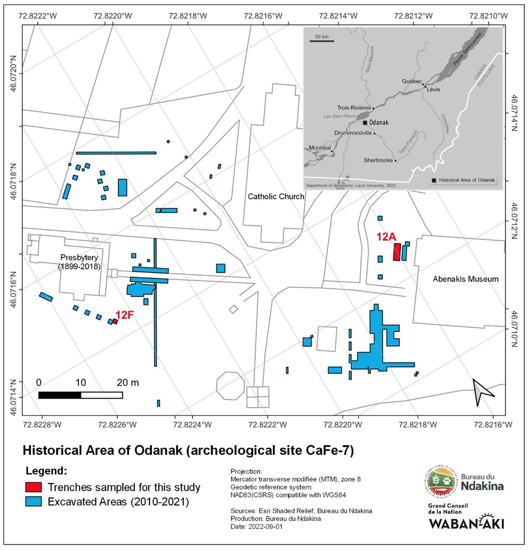
2. Study Area Characteristics and Sampling Strategy

2.1. Biogeophysical Setting of the Fort Odanak Site

The study area is situated in southern Québec in the Saint-Lawrence Lowlands, a geological province composed mostly of Cambro-Ordovician sedimentary rocks [41]. Surficial deposits comprise glacial tills and sedimentary deposits inherited primarily from the last Quaternary glaciation, the Wisconsin glaciation, that extended from approximately 75,000 to 11,000 years ago. These glacial sediments were initially overlain by marine clays and sandy sediments left by the Champlain Sea (between 12,900 and 10,000 BP) and then by lacustrine sands from Lake Lampsilis (at about 11,000 BP) [42]. The Fort Odanak archaeological site (CaFe-7) is located in Odanak, on a sandy alluvial terrace shaped by the Saint-François River. It has a mean elevation of 21 m above sea level (Figure 1) [14]. The Saint-François drainage basin covers a total surface area of 10,228 km2, and extends from the Appalachian foothills to the Saint-Lawrence River Valley, through the Chaudière-Appalaches, the Estrie and the Centre-du Québec regions in Canada and through a portion of northern Vermont in the United States [43,44]. The Saint-François River flows from Lake Saint-François, located in southern Quebec, southwest of the city of Sherbrooke, before branching northwest toward Lake Saint-Pierre, where it joins the Saint-Lawrence River [45]. Called Alsig8ntegw, “the river of shells” or “the empty cabin river”, by the Abenaki, the Saint-François River was used extensively by Indigenous communities over millennia as evidenced by both the rich prehistoric archaeological record along its course and by historical toponymy of the area [2,14,46,47]. The river and its affluents were part of the main portage routes that traditionally linked the Atlantic Coast to the Saint-Lawrence River [4,38]. These waterways offered rich faunal and floral resources and the Abenaki people used them as a means of travel between their different hunting, gathering and planting grounds throughout their ancestral lands [2,38,48].

2.2. Human Occupation and History of the Fort Odanak Site

Founded at the beginning of the 18th century, Odanak was originally a fortified Jesuit mission named Saint-François-de-Sales (St. Francis). This mission was initially built in 1683 at Sault-de-la-Chaudière, near Québec City, to receive newly converted Abenaki groups, arriving from New England, that settled in New-France after King Philipp’s War (1675–1676). In the early 1700s, the mission was moved to the Saint-François River (St. Francis River), an area long frequented by the Abenaki [2]. It was permanently established at the current village of Odanak around 1715 [9]. During the first half of the 18th century, the Saint-François-de-Sales mission became an important Abenaki gathering centre, providing refuge for displaced Abenaki groups and serving as the launching point for several military raids against New England [2,9,49]. It was described by French and English sources as a village of “considerable size” comprising several dozen houses, with both traditional dwellings (longhouses or wigwams) and European-style houses. Livestock were kept in the mission and each household possessed its own cornfield [50,51,52]. On 4 October 1759, as the Seven Years War drew to a close in America, the Saint-François-de-Sales mission was raided and burned by a group of American colonial rangers, only to be rebuilt by the Abenaki on the same location [2,9,52]. In 1828, a stone church was erected on the site, replacing the previous wooden structure. A Catholic school was built in 1887 (now the Abenaki Museum) accompanied by a presbytery in 1899 that was later demolished in 2018 [2,53]. Together with a small chapel, these buildings form the historical centre of the Abenaki village.

2.3. Archaeological Layers and Features Sampled in Areas 12A and 12F

Area 12A was a 4 m × 1.5 m excavation pit adjacent to the Abenaki Museum opened during the summer of 2018 (Figure 1). A small section of this area was not excavated due to the presence of a trench containing electrical wires. Five pit features, two hearths, thirty-five post holes and numerous ecofacts and artefacts (including ceramic vessels sherds and utensils, clay pipes, trade beads, tinkling cones and other metal ornaments, musket bullets, grapeshot, and gunflints, glass sherds, animal bones and charred maize) most of which are associated with 18th and 19th century occupations, were recovered (Figure 2A). The number of domestic features and the variety of cultural materials recovered during excavations led archaeologists to interpret 12A as a dwelling area [14]. Three of the pit features discovered in 12A, features 12A57, 12A72, and 12A64, were sampled for this study.
Area 12F was a 1 m × 1 m excavation pit located near the old presbytery. A pit feature, two postholes and a few artifacts and ecofacts were recovered here (Figure 1). The features were interpreted as remnants of the 18th century Abenaki occupation of the site, as they predated the construction of the Presbytery, but the limited size of the excavated area and the paucity of artifacts associated with the features prevented further interpretation of this area [14]. Sediment samples were taken from 12F50C for this study (Figure 2B).

2.4. Stratigraphic Data and Sediment Layers Sampled

On the archaeological site, which is identified by its Borden code–CaFe-7, natural alluvions from the Saint-François River form a thick yellowish unit of sand, over which layers of brownish archaeological sediments were identified (Figure 3).
In area 12A, a total of fourteen sediment layers were identified during excavations [14]. Archaeological layers associated with the occupation of the St-François-de-Sales mission were overlaid by an asphalt layer. Only four layers situated below this asphalt layer (12A11, 12A12, 12A13 and 12A14) were sampled in 12A (Figure 3 and Figure 4), as the upper layers (above the asphalt) were considered to be too recent for this study. In area 12F, five distinct sediment layers were identified during excavations [14], four of which were sampled for geoarchaeological analyses (12F2, 12F3, 12F4, and 12F5) (Figure 3 and Figure 4). Layer 12F1, formed by the present-day grassy soil surface, was not sampled. Layer 12F5 (area 12F) is interpreted as part of the same soil horizon as layer 12A14 (area 12A) since both consist of medium to coarse dark yellowish-brown sand and form the bottom stratigraphic layer of the two areas sampled on the site (Table 1).
A detailed description of the stratigraphic layers sampled in areas 12A and 12F is compiled in Table 1.

2.5. Pit Features Sampled

The four pit features sampled for this study were all small ovoid features with u-shaped or irregular profiles (Table 2; Figure 5). Mean diameters were less than 50 cm, and recorded depths ranged from 7 to 32 cm. A few small artifacts were found in all of the pits, and ecofacts (mostly bones and wood charcoal) were discovered in the three pit features from 12A (Table 2). Pit fill was mostly brownish and sandy, with occasional inclusions of charcoal (e.g., 12A57) or silty deposits (e.g., 12A64) in some features. None of the pits sampled exhibited clear internal stratigraphy.
The pit features sampled in Area 12A were all discovered during the excavation of layer 12A12 (Figure 6A–C). Pit features 12A57 and 12A72 appear to have been dug directly into layer 12A13, at the beginning of the occupation phase associated with 12A12. The stratigraphic position of pit 12A64 shows it to be near the transition between 12A11 and 12A12. Due to its stratigraphic position, this feature appears to be more recent than the previous two pit features. It was probably used toward the end of the period during which 12A12 was deposited. Pit feature 12F50C was discovered beneath layer 12F4 and was dug directly into 12F5 (Figure 6D). It constitutes the earliest evidence of human occupation in area 12F.

3. Methods

Particle size analysis and organic matter content analysis were carried out on all of the sediment samples collected in areas 12A and 12F of the Odanak Fort site (Table 3 and Table 4). Charred microfossils retrieved from the pits were also radiocarbon-dated to determine the chronology of human occupation in these areas of the site (Table 5). Micromorphology was used to document the deposits within the pits and the surrounding archaeological and natural sedimentary layers (Table 6 and Table 7).
Seventeen samples of bulk sediment were extracted in areas 12A and 12F from four pit features (12A57, 12A64, 12A72 and 12A50C) and eight sediment layers (12A11, 12A12, 12A13, 12A14, 12F2, 12F3, 12F4 and 12F5) for particle size analysis at the Laboratoire de géomorphologie et de sédimentologie of the Department of Geography (Université Laval, Québec). Samples were screened using a dry sieve column (1 to 16 mm) for the coarse mineral fraction (>1000 µm) and a laser granulometer Horiba LA950v2 for the fine mineral fraction (<1000 µm). Data were compiled using Gradistat software [54]. Loss on ignition was performed on the sediment samples to determine organic matter content [55]. Samples were heated for two hours at a temperature of 550 °C.
Radiocarbon dating was performed on four samples of charred raspberry or Rubus seeds from the pit features using accelerator mass spectrometry (AMS) at the 14C laboratory of the Centre d’études nordiques, Université Laval (UL) and the Keck Laboratory at the University of California, Irvine (UL-KIU). Due to their small size, none of the samples were pretreated with HCl. Radiocarbon dates were calibrated using the Calib 8.2 program [56,57] with the IntCal20 14C calibration curve for premodern features 12A57, 12A72 and 12F50C, and the CALIBomb program [58] with IntCal20 14C calibration curve and the NHZ1 post-atomic bomb 14C calibration curve for the modern 12A64 pit feature. Calibrations were calculated in BP and in AD years according to the highest probability value (2σ interval).
Micromorphological analyses were undertaken in order to (1) determine whether the pit features exhibited a distinct micromorphological signature in comparison to the surrounding archaeological layers; (2) identify the specific microscopic characteristics of each pit; and (3) detect the presence of a possible microstratigraphy in the examined features. Undisturbed and oriented sediment samples were first taken from eight archaeological layers and from four pit features of the site using steel kubiëna boxes (10 × 10 × 10 cm) (Figure 3, Figure 4, Figure 5 and Figure 6). A total of 9 kubiëna boxes were retrieved from which eighteen thin sections (~ 3.5 cm × 5.5 cm) were prepared at the Laboratoire de micro-géo-archéologie at Université Laval (Québec, QC, Canada). Soil samples were oven-dried, impregnated with polyester resin, sliced and thinned down to 30-μm-thick sections. These were studied in plane-polarized light (PPL) and crossed-polarized light (XPL) at the microscopy laboratory of the Centre d’études nordiques (Université Laval) using a Leica DM-4500 polarized microscope. Micromorphological descriptions follow Bullock et al. [59], Fitzpatrick [60], Goldberg and MacPhail [61] and Nicosia and Stoops [62].

4. Results

4.1. Grain Size and Organic Matter Content Results

The grain size parameters indicate that the sediment sampled from the archaeological layers of areas 12A and 12F are primarily mineral and sandy (Table 3 and Table 4). Organic content in the sediments is very low and constitutes 1 to 5% of the sediment fractions (Table 4). They are composed of poorly sorted medium to coarse sand with some gravel (2–6%) and silt (7–15%) (Table 3). Grain size distribution is skewed towards very fine particles, indicating a better sorting of coarser grains.
Table 3. Synthetic particle size data from sediment samples taken in areas 12A and 12F of the Fort Odanak site (CaFe-7).
Grain-Size DistributionStatistical Parameters (Logarithmic Moments)
Layer/FeatureN Gravel (%)Sand (%)Silt (%)Ms
(Φ)
So
(Φ)
Sk
(Φ)
Natural layers12A142Min.2.0088.208.201.061.671.72
Max.3.4089.808.501.461.851.84
Mean2.7089.008.351.261.761.78
SD0.700.800.150.200.900.06
12F51 5.7086.607.701.071.851.83
Archaeological layers12A113Min.1.8082.5010.801.491.921.23
Max.4.3086.014.901.742.101.52
Mean2.9084.412.601.642.011.35
SD1.041.451.710.100.070.12
12A123Min.3.0084.907.101.291.671.47
Max.3.7089.9011.501.441.981.84
Mean3.4387.309.301.361.831.61
SD0.312.051.800.060.131.16
12F31 2.6082.7014.701.692.131.38
12F41 2.0084.5013.401.572.081.51
Pit features12A571 6.3088.705.000.971.621.58
12A642Min.2.4082.7013.101.562.031.22
Max.2.6084.3014.901.712.071.42
Mean2.5083.5014.001.642.051.32
SD0.100.800.900.080.020.10
12A721 5.7087.506.701.081.751.46
12F50C1 2.1088.309.601.371.891.76
N: number of samples; Ms: mean size; So: sorting; Sk: skewness; SD: standard deviation.
Table 4. Organic matter content data from sediment samples taken in areas 12A and 12F of the Fort Odanak site (CaFe-7).
Layer/FeatureN Mineral Content (%)Organic Content
(%)
Natural layers12A142Min.97.302.00
Max.98.002.70
Mean97.652.35
SD0.350.35
12F51 98.701.30
Archaeological layers12A113Min.95.782.40
Max.97.604.22
Mean96.843.16
SD0.770.77
12A123Min.97.072.13
Max.97.872.93
Mean97.522.48
SD0.340.34
12F31 95.394.61
12F41 97.042.96
Pit features12A571 97.922.08
12A642Min.96.362.63
Max.97.373.64
Mean96.873.14
SD0.510.51
12A721 98.371.63
12F50C1 97.522.48
N: number of samples; SD: standard deviation.
A slight and gradual decrease in silt content was observed correlated with depth between ancient surface layers (i.e., 12A11 and 12F3) and deeper layers (i.e., 12A14 and 12F5), while sand proportions are higher in deeper layers (i.e., 12A14 and 12F5, B horizon) (Table 3). Organic content varies very slightly between sediment layers and presents a gradual decrease with depth (from 2–5% in 12A11 and 12F3 to 1–3% in 12A14 and 12F5). As supported by their brownish black color (Table 1), sediments from 12F3 show the highest organic content (4.61%) of all the samples (Table 4).
Grain size data of the pit features are similar to that of the archaeological layers but noticeably different from those of the natural layer (12A14 and 12F5). In fact, sediments from pit features, and archaeological layers are generally finer and less well sorted (Table 3 and Table 4). This could be explained by trampling and/or by organic and mineral inclusions resulting from human activities.

4.2. Radiocarbon Dating

Radiocarbon dates obtained for the four pit features are presented in Table 5. Both uncalibrated and calibrated dates are included in the table and ages are presented in cal. BP and cal. AD years. Results indicate that the 12F50C pit feature was used between the 15th and 17th centuries. First traces of human occupation in area 12F thus seem to predate the establishment of the Saint-François-de-Sales mission on CaFe-7 (around 1715). Features 12A57 and 12A72 are dated to the 18th century with a midpoint calibrated age in the 1760’s. The radiocarbon dates for these two features are consistent with the historical occupation of the site (after 1715) and the archaeological material found in the pits. As may be inferred from its stratigraphic position, feature 12A64 is more recent than the three other pits. It is dated to the 19th century with a midpoint calibrated age of around 1896.
Table 5. Radiocarbon and calibrated ages of the pit features from the Fort Odanak site (CaFe-7).
SampleLab. No.Age
(a BP)
Age
(Cal. a BP)
(2 σ)
Midpoint
Calibrated Age
(Cal. A BP)
Age (AD)
(2 σ)
Midpoint Calibrated Age (AD)Dated Material
CaFe-7-12A57ULA-10146195 ± 15148–190181AD 1760–1802AD 1769Charred Rubus seeds
CaFe-7-12A64ULA-1014890 ± 15Modern---AD 1877–1916AD 1896Charred Rubus seeds
CaFe-7-12A72ULA-10149185 ± 15164–219185AD 1731–1786AD 1765Charred Rubus seeds
CaFe-7-12F50CULA-10150325 ± 25309–461388AD 1489–1641AD 1562Charred Rubus seed

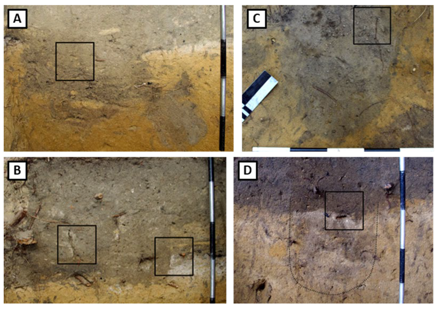
4.3. Micromorphological Data

At the microscopic scale, natural samples as well as archaeological samples (from archaeological layers and from pit features) showed similar characteristics in terms of mineral and organic components. The differences that distinguish each type of deposit relate to the frequency of anthropogenic micromorphological signatures and components and to natural post-sedimentary signatures.
Mineral sediments consist of subangular to rounded sand with some dispersed gravel (e.g., shale). Quartz grains are the predominant minerals, and secondary minerals include feldspars (mostly plagioclase and microcline), amphibole (hornblende), micas (primarily biotite and muscovite), and goethite. Garnet, opaque minerals and small iron oxide nodules are also present in lesser quantities.
The organic content includes root remains, plant cells, lignified tissues, wood remains, seed coat fragments, fungi (mostly Cenococcum graniforme sclerotia), spores, ectomycorrhizal mantles, and mesofauna droppings (especially enchytraeids and collembolan fecal pellets). The presence of highly decomposed organic matter and of fungal sclerotia within the sediment deposits indicates well drained local conditions. Small bone splinters and charcoal fragments were also found in some layers, confirming their anthropic nature.

4.3.1. Archaeological Layers of Areas 12A and 12 F

The micromorphological data of the sediment layers sampled at Odanak is presented in Table 6.
Table 6. Summary of micromorphological features of the sediment layers at the Fort Odanak site (CaFe-7).
Archaeological Layers Sampled
Area AArea F
12A1112A1212A1312A1412F212F312F412F5
Sample’s depth range to surface *~33 cm~38 cm~57 cm~56 cm~11 cm~11 cm~11 cm~33 cm
Mineral componentsCoarse mineral fraction (>63 µm)●● to ●●●●●●●●●●●●●●●●●●●●●●●
Fine mineral fraction (<63 µm)● to ●●●●●●●●●
FabricImImSg, ImPe, (Im)Ms, CpImImPe, (Im)
c/f related distributionCh, EnCh, EnMo, Ch, EnGe, (Po)PoCh, En, GeCh, EnGe, (Po)
VoidsSimple packing● to ●●●● to ●●
Compound packing
Complex packing●●●●●●● to ●●●● to ●●●●●●●●●●● to ●●●
Vughs
Vesicles
Channels● to ●●●●●
Chambers
Planes
b-fabricUnUnUnUn, Sp, GrUn, (Cr)UnUnUn, Sp, Gr
Specific microfeaturesMicrocircles/Rotational structures● to ●●●●●
Vertical grains● to ●●
Redox concentrations
Trampling●●● to ●●●●●●●
Organic componentsPlant fragments● to ●●●○ to ●●●● to ●●●●●
Cell/amorphous residues● to ●●
Seed fragments
Droppings by mesofauna● to ●●● to ●●●●●●●
Fungal components●●
Anthropic featuresCeramic fragments
Charcoal fragments●●○ to ●●●○ to ●
Bone fragments●●
Burnt bone fragments
Burnt organic matter
* Depth range to surface was measured from the center of the kubiëna boxes. ○ absent/not observed; ● low/few/poorly developed; ●● medium/frequent/moderately developed; ●●● high/abundant/well developed; Fabric: Im, intergranular microaggregates; Sg, single grain; Cp, compact; Ms, massive; Pl, planar; Pe, pellicular; C/f related distribution: Mo, monic; Ch, chitonic; Ge, gefuric; En, enaulic; Po, porphyric; b-fabric: Un, undifferentiated or absent; Gr, granostriated; Sp, speckled; Cr, cristallitic;.
  • Area 12
1.
Layer 12A11
This layer was located beneath the asphalt layer at the top of the excavated area in 12A; consequently, it is the most recent layer sampled in this area. Micromorphological analysis reveals the presence of soil faunal channels and fecal pellets in the groundmass indicating that these sediments underwent pedogenetic processes. Traces of human occupation evident in the form of several bone splinters (some of which are burned) and charcoal fragments have been integrated into the sediments (Table 6). The fabric is made of intergranular microaggregates of fine organic material, and the c/f related distribution is chitonic and enaulic. Layer 12A11 is characterized by alternating beds of medium to coarse sand with a high organic content, and beds formed by well sorted medium sand, with a greater proportion of opaque minerals. Water seems to have played an important role in the sedimentology of this layer.
2.
Layer 12A12
Transition between layers 12A11 and 12A12 is progressive and these layers show similar micromorphological signatures with a fabric of intergranular microaggregates, and a chitonic and enaulic c/f related distribution. Traces of soil fauna activity are also present in this layer as both fecal pellets and small fragments of decomposed organic matter have been incorporated into the plasma. However, the thin section of 12A12 shows stronger evidence of human occupation than layer 12A11 with the presence of larger and more numerous charcoal fragments. Seed fragments possibly from Rubus species [63,64,65,66] and bone splinters were also identified, suggesting the presence of food remains. Sediments from 12A12 are poorly to moderately sorted, and several large mineral grains are vertically oriented, which further suggests anthropogenic signatures such as trampling. The micromorphological data of 12A12 is consistent with that of a human occupation layer.
3.
Layers 12A13 and 12A14, buried soil horizons
Layer 12A13 was identified across large sections of the CaFe-7 site. Because of its striking resemblance to an ash and charcoal layer, it was interpreted during field excavations as the archaeological layer associated with the 1759 attack on the mission, an episode that resulted in the destruction by fire of the Abenaki village. In previous interpretations of the site, this layer served as a chronostratigraphic marker [14].
However, micromorphological analysis of the sediments from that layer did not reveal any sign of ashes or burned sediments. Typical components of plant ash residues, such as siliceous phytoliths, calcium oxalate crystals, calcium carbonate aggregates or vesicular glassy slags [67,68,69] are absent from the sedimentary deposits of layer 12A13. Under crossed polars, the fine fraction shows an undifferentiated b-fabric and does not exhibit the strong birefringence characteristically displayed by calcite crystals [67,70] (Figure 7C,D). Furthermore, low-order white and grey interference colors expected from a submicroscopic crystalline plasma made of fine ash [69,71,72] were not observed.
Microscopic analyses showed that layer 12A13 is in fact the A horizon of a brunisol [73] buried under the archaeological sediments of layers 12A11 and 12A12. This topsoil is composed of a thin dark Ah horizon (≤3 cm in thickness) overlying an eluviated whitish Ae horizon (3–6 cm-thick). The Ah horizon is formed by a dark layer of decomposed organic matter (mainly plant and fungi remains) and intergranular microaggregates that partially fill in the voids between the mineral grains (Figure 7A,B). The presence of a few root channels and chambers indicates some bioturbation. In the eluviated horizon, the c/f related distribution appears generally monic, as most mineral grains are uncoated and have a single grain fabric. A few microaggregates of fine material were detected in the intergranular spaces but the plasma is scarce and highly mineral, with a greyish color due to iron oxide depletion and an abundance of quartz and feldspar (Figure 7C,D).
Layer 12A14 comprises the B and C horizons of the buried paleosol [73]. The Bf accumulation horizon shows a pellicular fabric with a well-developed coating of fine material on the mineral grains (Figure 7E). Accumulation of clay particles and iron oxides in this horizon has created a characteristic yellowish plasma, made of fine oxidized mineral material (Figure 7F,G). The birefringence-fabric is generally stipple-speckled with weak granostriation around some of the mineral grains (Figure 7G). Porosity is still important, confirming the young pedologic age of the sediment (brunisol). There are very few traces of soil fauna activity in the B horizon, as ancient mesofauna droppings are still visible in the fine matrix but appear highly altered (Figure 7E). Only a few small organic fragments, covered by fine plasmic material were found in the groundmass.
  • Area 12F
1.
Layer 12F2
This layer, located at the top of the excavated area in 12F, was the only sediment layer sampled on the CaFe-7 site that showed a marked difference in both mineralogical and organic composition from the other stratigraphic layers. It is a silty deposit, indicating that it is exogenous to the site. The contents of this layer are almost entirely mineral, and comprise subangular quartz and feldspar grains, and biotite fragments. 12F2 exhibits a massive and compact fabric with a porphyric c/f related distribution. It shows clear evidence of having been compressed and appears molded onto the underlying layer of 12F3. Layer 12F2 is thus interpreted as a modern and artificial layer of filling material added to the site for levelling purposes, probably in 2005 as a result of the landscaping of the grounds situated between the presbytery and the Abenaki Museum [14].
2.
Layer 12F3
The thin section from 12F3 showed a significant proportion of organic matter as well as evidence of pedogenesis processes. In fact, the sediments display a high porosity with abundant channels and chambers resulting from bioturbation. The fabric of the sediments is formed of numerous intergranular microaggregates of highly decomposed organic matter (mostly aggregated mesofauna droppings) deposited between uncoated mineral grains. The c/f related distribution is chitonic, enaulic, and gefuric in some places. Post-sedimentary processes are emphasized in this horizon by the presence of numerous micro-circular structures and several vertically oriented mineral grains in the fabric that may be related to cryogenic processes. The rich organic nature of this soil indicates that it was likely amended with compost, either from the vegetation that naturally grew on its surface or by human action. The presence of a few microscopic charcoal and bone fragments indicates a moderate anthropization of the sediments.
3.
Layer 12F4
Sediments from layer 12F4 show a chitonic and enaulic c/f related distribution, and a fabric made of intergranular microaggregates. Traces of pedogenetic processes and bioturbation are less marked than in the overlying layer, and the organic content of the sediments is lower. Traces of human occupation are visible in the sediments with the presence of small bone splinters, some of which are burned. The micromorphological features of this layer are consistent with those of an occupation layer.
4.
Layer 12F5
Layer 12F5 shows similar micromorphological characteristics to layer 12A14 and the absence of ecofact or artifact fragments in thin section. It is part of a slightly pedogenized brunisolic B horizon. Mineral grains exhibit a coating of fine oxidized material and some interstitial organic matter was detected between the grains. The Ae eluviated horizon (12A13) identified in area 12A is not visible in 12F. It was either less developed in this area or was possibly removed by construction and other activities carried out by the Abenaki community at the site.

4.3.2. Archaeological Pit Features

A summary of micromorphological features characterizing sediments from the archaeological pits of Odanak is presented in Table 7. Pit features are grouped chronologically according to the radiocarbon dates obtained from their contents.
Table 7. Summary of micromorphological observations for the pit features of the Fort Odanak site (CaFe-7).
CaFe-7 Pit Features
15th–17th Century Feature18th Century Features19th Century Feature
12F50C12A5712A7212A64
Sample’s depth range to surface *~33 cm~55 cm~60 cm~58 cm
Mineral componentsCoarse mineral fraction (>63 µm)●●●●●●●●●● to ●●●
Fine mineral fraction (<63 µm)● to ●●● to ●●●
FabricImImImIm, Pl, Ms, Cp
c/f related distributionCh, EnCh, EnCh, EnCh, En, Ge, Po
VoidsSimple packing● to ●●● to ●●● to ●●
Compound packing
Complex packing●●●●●●●●●●●●
Vughs
Vesicles
Channels● to ●●● to ●●● to ●●
Chambers
Planes●● to ●●●
b-fabricUnUnUnUn
Specific microfeaturesMicrocircles/Rotational structures● to ●●
Vertical grains● to ●●
Redox concentrations
Trampling
Organic componentsPlant fragments● to ●●●●●● to ●●
Cell/amorphous residues● to ●●● to ●●● to ●●
Seed fragments● to ●●
Droppings by mesofauna●● to ●●●● to ●●●● to ●●●●●
Fungal components
Anthropic featuresCeramic fragments●●
Charcoal fragments●●●●●
Bone fragments●●●●●●● to ●●
Burnt bone fragments
Burnt organic matter
* Depth range to surface was measured from the center of the kubiëna boxes. ○ absent/not observed; ● low/few/poorly developed; ●● medium/frequent/moderately developed; ●●● high/abundant/well developed; Fabric: Im, intergranular microaggregates; Sg, single grain; Cp, compact; Ms, massive; Pl, planar; Pe, pellicular; C/f related distribution: Mo, monic; Ch, chitonic; Ge, gefuric; En, enaulic; Po, porphyric; b-fabric: Un, undifferentiated or absent; Gr, granostriated; Sp, speckled; Cr, cristallitic.
The mineral composition of the pit features is similar to that of archaeological layers sampled on the site. The mineral constituents within the pits are thus inherited from the alluvions that form the terrace on which the CaFe-7 site is situated, indicating that the pits contents are primarily composed of local anthropized sediments (Figure 8C,D).
Organic components are also similar to those found in the archaeological layers, but their size and abundance sometimes differ. Wood charcoal was found in all of the pits, and both coniferous and leafy fragments were identified. Bone fragments were found in three of the pits (12F50C, 12A57, and 12A72), while two contained ceramic fragments (12F50C and 12A64).
Sediments from the pit features show an overall chitonic and enaulic c/f related distribution (Table 7). The fabric consists of intergranular microaggregates of organic matter arranged between generally uncoated or very thinly coated mineral grains (Figure 8A,B). In pit feature 12A64, the microstructure of the contents revealed additional characteristics, including the presence of a silty deposit incorporated into the sandy sediments (Table 7 and Figure 8G).
  • Feature 12F50C (15th–17th century)
Deposits from 12F50C show strong evidence of pedogenetic processes, since several channels and chambers created by roots and mesofauna were observed along with fecal pellets (Figure 8A). Human occupation is indicated by numerous bone fragments (some of which are burnt) and the presence of a 4 mm-long ceramic fragment (Figure 9G,H). The micro-sherd has angular edges and appears slightly burnt on the outside (Figure 9E). It is composed of fine brownish clayey material with small quartz inclusions and displays a strong birefringence under crossed polarizers (Figure 9F).
  • Feature 12A57 (18th century)
Feature 12A57 contains by far the greatest amount of both carbonized and non-carbonized wood remains (Figure 9A). The presence of large charcoal fragments in thin sections suggests that hearth residues constitute a significant part of the feature’s contents. Fragments of seed coats, probably from Rubus species [63,64,65,66], were also observed in larger proportions in thin sections from this pit more than for the other features. Rubus seeds are frequently found on archaeological sites as raspberries/blackberries were consumed by both Indigenous and European populations [74]. Their abundance in archaeological sediments is usually interpreted as an indication that either food remains or human excrement were deposited in the soil (Figure 9B,C) [75,76,77].
  • Feature 12A72 (18th century)
12A72 is the only pit in which several fragments of burnt coniferous needles were detected, suggesting the possible use of coniferous branches as fuel for a domestic fire (Figure 9D). Wood charcoals and burnt organic matter were also observed in this pit. The contents of the pit are highly organic with a marked diversity of mesofauna droppings (Figure 8E,F), plant remains, sporangiums and fungi material.
  • Feature 12A64 (19th century)
The most notable characteristic of feature 12A64 is the inclusion of silty deposits with a mainly porphyric c/f related distribution within the local sandy sediments. This silty fraction exhibits a massive laminar fabric with a specific microstructure (Figure 8G,H). Typical cryogenic features such as planar voids, microcircles (Figure 8I) and vertical or near-vertical detrital grains were observed. These features were probably caused by frost action and freeze/thaw cycles that occurred during a period of intense cold [78,79]. Anthropic content found within the pit consisted of several ceramic micro-fragments, comprising green and blue layers that possibly originated from pottery glazing (Figure 9I,J).

5. Discussion

The geoarchaeology of the Fort Odanak site has made it possible to reconstruct the evolution of areas 12A and 12F in response to both natural and anthropogenic processes, and to clarify the construction and use of pit features. Geoarchaeological analyses carried out on the archaeological sediments sampled in 12A and 12F modify our understanding of the stratigraphy of the site, and provide new data on the chronology of Abenaki occupation in these sectors.

5.1. Temporal Evolution of Areas 12A and 12F

The micromorphology of areas 12A and 12F reveals that following their deposition, sandy alluvions from the Saint-François River subsequently underwent pedogenetic processes that led to the formation of a brunisol. This soil is composed of a thin eluviated A horizon (12A13) overlying an oxidized B horizon (12A14 and 12F5), into which iron and aluminium compounds leached from the topsoil. Brunisols are moderately developed soils, with weak but visible horizon differentiation, frequently found in Canadian forested environments [80,81,82]. In the midstream of the Saint-François River, brunisolic profiles are predominant in alluvial bank soils. Surface sediments are regularly incremented with new deposits during river flooding, which hinders surface litter accumulation and contributes to soil rejuvenation [83]. In the vicinity of Odanak, gleysols, podzols, and brunisols constitute the most common types of soil [84]. At the Fort Odanak site, the Abenaki settled on a forested soil, likely covered by vegetation, in which pedogenic processes of the local sandy sediments was taking place.
According to our results, the earliest evidence of human occupation at the site (12A area) was dated to the second half of the 18th century, most likely after 1760 AD, as indicated by the radiocarbon dates obtained for pit features 12A57 and 12A72. Sediments from archaeological layers deposited from this first occupation onward (12A12 and 12A11) were primarily from local Saint-François River alluvions, as demonstrated by their mineral composition and grain size, but they exhibit a distinct micromorphological signature in comparison with that of the underlying natural soil layers (12A14). Their anthropic signature is characterized by a different microstructure (e.g., uncoated mineral grains, organic interstitial plasma, evidence of sediment trampling) and by the presence of anthropogenic inclusions (e.g., bone splinters and wood charcoal micro-fragments) in their coarse fractions. Continued human occupation involving a variety of household activities on the site during the mission period, could explain the integration of bone fragments and relatively larger (≥4 mm) and more abundant charcoal fragments into the archaeological sediments via both anthropic and pedogenetic processes. Domestic activities involving the use of pit features seem to have been carried out on the site until the late 19th century between A.D. 1850–1880, when pit feature 12A64 was created. Cryogenic microfeatures such as those detected on thin sections from 12A64 (e.g., the microcircles and typical laminar microstructure) are common in the permafrost of arctic and subarctic regions [85], but the present climate of southern Quebec is too warm to create such features. Such a cryogenic signature was not observed in the coarser sediment fraction of the pit, suggesting that the recording of this cooling episode could only occur in fine sedimentary material. Considering its stratigraphic position in area 12A and the results of the radiocarbon analysis, this pit feature was likely used by the Abenaki during the second half of the 19th century, probably circa A.D. 1850–1860, when the Little Ice Age reached its peak in southern Quebec [86,87,88].
Photos taken at the Odanak Fort site at the end of the 19th century before the construction of the Catholic school (in 1887) show that the part of the site in which 12A is located was covered by a lawn without extant dwellings. Layer 12A11 was associated with the period during which the school was used (1887–1965) [14] and micromorphological analyses are consistent with this interpretation as they reveal that sediments from 12A11 were exposed to external climatic factors, that left visible traces on the surface of the soil. For instance, the fine laminated and sorted sand observed on thin sections from 12A11 was interpreted as low to moderate intensity surface runoff deposits that could be linked to the flooding of the Saint-François River. The presence of anthropogenic fragments scattered throughout layer 12A11 suggests that at least part of the local sediments remained in place during those climatic events. The Saint-François River is well-known for its significant flooding events especially during the spring season [44,89]. The municipalities of Saint-François-du-Lac, Pierreville and Notre-Dame-de-Pierreville, located nearby, have all been affected historically by recurring floods due to abundant rainfalls or ice jams [90,91]. Although the surface sediment layers at the CaFe-7 site were unlikely to have been directly affected by the Saint-François River floods because of the site’s altitude (at about 9 m above the river [45]), local sediment flooding could have taken place on the site due to the proximity of a small stream that once flowed near the Catholic church [92]. Following their deposition, the sediments in 12A11 also underwent pedogenetic processes (as evidenced by the presence of root channels and soil fauna fecal pellets in the groundmass) before being eventually covered by a layer of asphalt.
In area 12F, the eluviated horizon of the natural topsoil seems to have been removed by the site’s occupants in this sector, as archaeological sediments relating to the first human occupation (12F4) were deposited directly on the B horizon of the original local brunisol (12F5). Radiocarbon dating of pit feature 12F50C suggests that the first human occupation in 12F predates the 18th century mission settlement on CaFe-7, and took place sometime between the 15th and the 17th centuries. Past archaeological surveys along the banks of the Saint-François River have demonstrated that the region of Odanak was visited by the W8banakiak (Abenaki) during pre-colonial times, as several cultural markers associated with their presence (such as shell beads, herring bones, and clay concretions engraved with symbols known to the Abenaki nation) were documented for this period [2,10]. Previous radiocarbon dates obtained for several fragments of wood charcoal also hint at a possible Abenaki presence on the CaFe-7 site during the 16th century [2]. Micromorphological characteristics of the archaeological deposits in 12F (i.e., 12F3 and 12F4) are similar to those of the archaeological layers of 12A (i.e., 12A12 and 12A11), both in terms of sediment microstructure and anthropic inclusions. Historical photos of Odanak’s presbytery, dated from the beginning of the 20th century, show that a garden space was laid out by the Jesuit priests in the vicinity of area 12F. Cultivation of the soil during this period could account for the rich organic nature of the sediments from layer 12F3 (e.g., the accumulation of vegetal remains at its surface) and the abundant traces of soil reworking processes (e.g., spheric aggregates, channels, fecal pellets left by pedofauna) observed micromorphologically in this layer. Gardening activities could also possibly have contributed to the destruction of the eluviated natural top soil horizon. In 2005, landscaping of the grounds in Odanak’s historical centre was undertaken and resulted in the burial of archaeological deposits in area 12F under a layer of fill material (12F2) [14].

5.2. Pit Features’ Construction and Use

This geoarchaeological investigation of the pit features is the first of its kind to be conducted in Quebec. The four pits studied were not rich in cultural material, therefore, the micromorphological analysis provided an additional tool in understanding their function and construction. Particle size analysis, organic content analysis and micromorphological analysis showed that the pit fills were mainly composed of local soil sediments, to which organic matter and anthropogenic components were added by natural processes and human occupation. As evidenced by the micromorphological finding, all of the pits exhibited an anthropic signature at the microscopic level that is similar to that of the archaeological layers sampled on the site. In the case of pit features 12A57 and 12F50C, however, this signature is more pronounced than that of contemporary archaeological deposits.

5.2.1. Primary Refuse Pits

The four pits studied all seem to have served as refuse facilities prior to abandonment, as suggested by the diversity of fragmented anthropic materials that were recovered from their contents (e.g., varied vessel sherds, tool fragments, ornaments, food remains, etc.). Features 12A72 and 12F50C were likely used primarily for this purpose, as indicated by their very small dimensions and their irregular profiles [3,16]. The scarcity of cultural material recovered from these two pit features points to the disposal of mostly organic refuse in these facilities, which could account in turn for the significant concentration of mesofauna fecal pellets in their sediments (Table 6). However, organic content analysis of the sediments shows that the organic matter deposited in these pits was subsequently highly decomposed by pedogenetic processes (Table 4). In the case of pit feature 12F50C, the high decomposition of the organic remains is explained by its older age as compared to the other pit features. Evidence of domestic waste was observed in the sediments of this pit (e.g., bone fragments, ceramic sherds), but the refuse cannot be associated with a specific type of activity.
In pit feature 12A72, the artifact content was scant but micromorphological observations have highlighted traces of consumption refuse (bones, Rubus seeds) and hearth deposits (charcoal fragments, charred coniferous needles), suggesting that this pit served as a receptacle for the disposal of specific type of waste (e.g., related to food consumption and preparation).

5.2.2. Potential Primary Storage Pits

The artifacts and ecofacts found in 12A57 and 12A64 suggest their singular function as loci for refuse disposal. Their modest dimensions and relatively shallow profiles do not, at first glance, classify them as being typical of Indigenous storage features found in the Northeast [3,16,19,22,30,93] although studies have shown that pit dimensions could be considerably affected by post-abandonment disturbances at the surface (e.g., plowing, surface stripping during excavations) [3,16,17]. Neither pit lining nor bark container fragments indicative of food storage [15,19,30,93] were detected in these features via excavations or geoarchaeological analyses, but wood fragments are well represented in the sediments from 12A57. However, the morphological characteristics of these two features such as their U-shaped profile, straight walls and flat-bottoms (more evident in the case of 12A64), potentially hint at a different primary function other than refuse disposal [15,16,19,30,93]. Moreover, neither feature was completely excavated as they were only partially visible in area 12A (Figure 2A). It is therefore possible that documentation of their complete shape and dimensions would have revealed additional information about their original function.
The significant proportion of charred residues in 12A57 indicate that this pit was situated near a domestic hearth. Furthermore, the marked presence of bone fragments and Rubus seeds suggests its use for the disposal of cooking waste. Complete objects were not recovered in pit 12A57 but the relative abundance and diversity of artifact fragments (e.g., ceramic and glass sherds, construction nails, pipe fragments, diverse glass beads, etc.) points to the presence of floor debris in this pit [16]. Because of their spatial proximity, the similarity of their contents and their contemporary radiocarbon dates, it seems that features 12A57 and 12A72 were used for the disposal of cooking and hearth residues from the same household. Micromorphological analysis of these two pit features is compatible with the nearby presence of a late 18th century Abenaki household on the site, in which domestic activities involving food preparation and consumption took place [14].
Neither traces of hearth deposits or food remains were detected in the microscopic analysis of sediments from the 12A64 pit. Only tiny green ceramic fragments, indicating a human presence, were found intermingled with the coarse fraction. A few artifact fragments and small bone splinters were discovered in this pit during field excavations, but the overall anthropic signature of the pit’s sedimentary fill is weak at the microscopic level. It is thus possible that pit feature 12A64 was not intended for a specific type of waste but that it was in fact backfilled with local soil sediments and debris after having served a different initial function (e.g., food storage) [16,22,93]. The presence of silty inclusions in this feature is not clearly understood, but could potentially be related to the practice of craft activities by local inhabitants.

5.3. Pit Construction and Explanation

The absence of stratification indicating repeated use over time within the four pit features studied points to a single filling-event prior to abandonment [3,16]. They therefore appear to have been left open for a short period of time. It is safe to assume that small primary refuse pits, like features 12A72 and 12F50C, were quickly filled with refuse after being dug, as they were created for the express purpose of discarding waste. In the case of larger pit features such as 12A57 and 12A64, it is also possible that after being emptied of their original contentS, these pits were also backfilled rapidly with local sediments and debris for safety purposes, as was observed by Hambacher and Schaetzl for large cache pits in the Great Lakes region [93]. The filling of the four pit features during household cleaning events could potentially account for both the heterogeneity of artifact and ecofact fragments discovered (as complete pieces were scarce among the materials recovered) and the similarities observed between pit fill and sediments from the surrounding archaeological layers [16]. If this is the case, the sediment are a mixture of domestic waste, floor debris and sediments from the occupied soil surface, incorporated into the archaeological record during household maintenance.
Previous experiments on pit formation conducted by Timmins [16] over a period of several years, show that pit fill can be considerably affected by post-abandonment processes. Stratigraphic slumping and compression, animal disturbance (resulting for instance in the upward movement of bones) and wall collapse when pits are left open can significantly alter their morphological and internal characteristics. Such experiments have also described the significant homogenization of pit deposits by pedogenetic processes. A few years after abandonment, generally only depositional events involving thick layers of distinctive material can still be identified and visible strata is often the result of several depositional events [16]. The extent of pit fill homogenization on the Fort Odanak site is not precisely known, but prevailing well-drained conditions in the local sandy sediments and bioturbation could have potentially erased stratification in some of the features from 12A and 12F.

6. Conclusions

This first micromorphological and chronostratigraphic study of the Fort Odanak site provides an interesting perspective on the archaeological sediment deposits. Analysis of the sediments’ structure and composition at a microscopic scale enables us to differentiate natural soil layers from archaeological occupation layers. For example, micromorphological analysis provides new data that improve our understanding of the site’s stratigraphy and occupation over time.
Our results from sector 12F indicate that the first occupation of CaFe-7 took place before the settlement of the mission, and sector 12A was occupied after 1760, during the reconstruction of the village following the 1759 raid. Two distinct periods of domestic occupation that resulted in the creation of refuse pits have been highlighted in area 12A. The use of traditional pit features by the Abenaki of Odanak appears to have continued into the second half of the 19th century. Our study indicates that the layout of the Saint-François-de-Sales mission varied over time after its establishment in the early 18th century. Significant restructuring of settlement patterns on CaFe-7 likely occurred as successive groups of Abenaki refugees joined the mission during the colonial period, and after the destruction of the village in 1759. The gradual adoption of European-style architecture and lifeways by the mission’s inhabitants also generated permanent changes in village organization.
The studied pits yielded few artifacts and ecofacts during excavations but micromorphological analyses provided valuable and relevant information about the contents and original functions of the pits. The 18th century pits (12A57 and 12A72) discovered in area 12A contain hearth deposits and consumption refuse, suggesting that food processing and cooking likely took place in a nearby household. The detection of exceptional climatic events associated with the Little Ice Age in the 19th century feature (12A64) further clarifies its period of use. Two of the pit features, 12A72 and 12F50C, have been identified as primary refuse pits that were likely created to bury mostly organic waste, while the larger features, 12A57 and 12A64, are thought to have been backfilled with a mixture of domestic waste, floor debris and local soil sediments, possibly after having served an initial storage function. Additional analysis of the archaeological features and layers sampled is needed to confirm the interpretations proposed in this study, but micromorphology appears to be a promising tool for the characterization and interpretation of pit features on archaeological sites.
Finally, this analysis provides a cautionary tale in site interpretation as it reveals the importance of using multiple methods in archaeology. Archaeobotanical analyses are currently being carried out to complement the micromorphological data from four archaeological features presented in this paper. These additional analyses will provide a larger overview of the composition of archaeological deposits on the site and further help to document the pit features at the Fort Odanak site.

Author Contributions

Conceptualization, S.R., N.B. and A.B.; methodology, S.R. and N.B.; validation, S.R., N.B. and A.B.; investigation, S.R.; resources, N.B. and A.B.; writing—original draft preparation, S.R.; writing—review and editing, N.B. and A.B.; supervision, N.B. and A.B.; project administration, N.B. and A.B.; funding acquisition, N.B. and A.B. All authors have read and agreed to the published version of the manuscript.

Funding

This research was funded by FRQ-SC, 2021-SE3-283916, and CRSNG, RGPIN-2020-06699.

Data Availability Statement

Data is contained within the article.

Acknowledgments

This work is the result of an ongoing collaboration between the Grand Conseil de la Nation Waban-Aki (GCNWA), the Abenaki Museum of Odanak, and Université Laval. The authors wish to thank the GCNWA, the Abenaki Museum, the Groupe de Recherche en Archéométrie (GRA), and the Centre d’études nordiques (CEN) of Université Laval for making this research possible. Logistical support and accommodation during field work at Odanak was provided by the GCNWA and the Abenaki Museum. The authors wish to acknowledge the work of the field crew that participated in the 2018 archaeological campaign at Odanak, the contributions of Geneviève Treyvaud, Roxane Lévesque, Serena Hendrickx, Jean-Nicolas Plourde and Daniel Ducharme are greatly appreciated. Special thanks are also extended to Suzie O’Bomsawin and David Bernard of the Ndakina research office (GCNWA), and Mathieu O’Bomsawin and Patricia Lachapelle from the Abenaki Museum for their help and ongoing support. We also wish to thank the Abenaki community of Odanak for their warm welcome and encouragement during the archaeological excavations. Thin sections were prepared by Stéphane Ferré (Université Laval) and grain size analysis and organic matter content analysis was performed by Guillaume Pouliot (Université Laval). Radiocarbon dating was undertaken by Guillaume Labrecque (CEN) and the radiocarbon results were calibrated by Joshua Tremblay (CEN) and Sarah Robert (Université Laval). Maps of the archaeological site and excavated areas were created by the Ndakina research office (GCNWA), Thomas Robert, and Louise Marcoux (Université Laval), and stratigraphic figures were prepared by Louise Marcoux (Université Laval). Thanks also are extended to Ann Delwaide (CEN) for her help in the study and with the identification of wood charcoal remains. The authors also thank the reviewers for their careful reading of this manuscript and helpful comments.

Conflicts of Interest

The authors declare no conflict of interest.

References

  1. Calloway, C.G. The Abenaki; Indians of North America; Chelsea House Publishers: New York, NY, USA, 1989. [Google Scholar]
  2. Treyvaud, G.; Plourde, M. Les Abénakis d’Odanak, un Voyage Archéologique; Musée des Abénakis: Odanak, QC, Canada, 2017. [Google Scholar]
  3. Cowie, E.R. Continuity and Change at Contact Period Norridgewock. Ph.D. Thesis, University of Pittsburgh, Pittsburg, CA, USA, 2002. [Google Scholar]
  4. Sévigny, P.-A. Les Abénaquis: Habitat et Migrations, 17e et 18e Siècles; Editions Bellarmin: Montréal, QC, Canada, 1976. [Google Scholar]
  5. Calloway, C.G. Dawnland Encounters, Indians and Europeans in Northern New England; The University Press of New England: Hanover, NH, USA, 1991. [Google Scholar]
  6. Snow, D.R. Eastern Abenaki. In Handbook of North American Indians; Trigger, B.G., Ed.; Smithsonian Institution: Washington, DC, USA, 1978; Volume 15, pp. 137–148. [Google Scholar]
  7. Morrison, K.M. The people of the Dawn: The Abnaki and their relations with New England and New France, 1600–1727. Ph.D. Thesis, Université du Maine, Orono, ME, USA, 1975. [Google Scholar]
  8. Boulanger, M.T.; Hill, D.H. Petrographic Analysis of Contact Period Native American Pottery from Fort Hill (27CH85), Hinsdale, NH, USA. Archaeol. Anthropol. Sci. 2015, 7, 517–532. [Google Scholar] [CrossRef]
  9. Charland, T.-M. Les Abénaquis d’Odanak (1675–1937); Editions du Lévrier: Montréal, QC, Canada, 1964. [Google Scholar]
  10. Treyvaud, G.; Plourde, M. Prospection Archéologique, Odanak, 2010; Archaeological Excavation Report; Musée des Abénakis: Odanak, QC, Canada, 2011. [Google Scholar]
  11. Treyvaud, G.; Plourde, M. Odanak, Fouilles Archéologiques 2011–2012; Archaeological Excavation Report; Musée des Abénakis: Odanak, QC, Canada, 2013. [Google Scholar]
  12. Treyvaud, G.; Plourde, M. Odanak, Fouilles Archéologiques, Prospection sur la Rivière Saint-François 2013; Archaeological Excavation Report; Musée des Abénakis: Odanak, QC, Canada, 2014. [Google Scholar]
  13. Treyvaud, G.; Dallaire-Fortier, C. Fouilles Archéologiques sur la Rivière Saint-François 2014, «Tagwa8ganek, La Pointe du Moulin CaFe-9», «Le Village Fortifié des Abénakis d’Odanak CaFe-7»; Archaeological Excavation Report; Musée des Abénakis: Odanak, QC, Canada, 2014. [Google Scholar]
  14. Treyvaud, G.; Lévesque, R. Interventions Archéologiques sur les Sites CaFe-7 (Odanak) et CcFc-3 (Bécancour); Archaeological Excavation Report; Musée des Abénakis: Odanak, QC, Canada, 2019. [Google Scholar]
  15. Bursey, J. Storage Behaviour in the Northeast: A Review of the Evidence. N. Am. Archaeol. 2001, 22, 179–199. [Google Scholar]
  16. Timmins, P.A. The Calvert Site: An Interpretive Framework for the Early Iroquoian Village; Canadian Museum of Civilization Mercury Series, Archaeological Survey of Canada Paper 156; Canadian Museum of Civilization: Ottawa, ON, Canada, 1997. [Google Scholar]
  17. DeBoer, W.R. Subterranean Storage and the Organization of Surplus: The View from Eastern North America. Southeast. Archaeol. 1988, 7, 1–20. [Google Scholar]
  18. Engelbrecht, W. Iroquoia, the Development of a Native World; Syracuse University Press: Syracuse, NY, USA, 2003. [Google Scholar]
  19. Dunham, S. Cache Pits: Ethnohistory, Archaeology, and the Continuity of Tradition. In Interpretations of Native North American Life; Nassaney, M.S., Johnson, E.S., Eds.; University Press of Florida: Gainesville, FL, USA, 2000; pp. 225–260. [Google Scholar]
  20. Tooker, E. Ethnographie des Hurons, 1615–1649, 6th ed.; Fouchier-Axelsen, B., Translator; Coll. Signes des Amériques; Recherches Amérindiennes au Québec: Montréal, QC, Canada, 1987. [Google Scholar]
  21. Gostick, K. If Pits Could Talk: An Analysis of Features from the Figura Site (AgHk-52). Master’s Thesis, University of Western Ontario, London, ON, Canada, Electronic Thesis and Dissertation Repository, n° 4632. 2017. Available online: https://ir.lib.uwo.ca/etd/4632 (accessed on 8 May 2019).
  22. Stewart, M.C. Typology of Pits on the Englebert Site. Ph.D. Thesis, State University of New York, Bingham, NY, USA, 1975. [Google Scholar]
  23. D’Avignon, M. Samuel de Champlain: Premiers Récits de Voyages en Nouvelle-France 1603–1619; Les Presses de l’Université Laval: Québec, QC, Canada, 2009; Available online: https://canadacommons-ca.acces.bibl.ulaval.ca/artifacts/1882065/premiers-recits-de-voyages-en-nouvelle-france-1603-1619/2631283 (accessed on 27 July 2022).
  24. Lafitau, J.-F. Moeurs, Coutumes et Religions des Sauvages Américains; Ser. Cihm/Icmh Microfiche Series, no. 38671; Périsse: Lyon, France, 1839; Available online: https://www.canadiana.ca/view/oocihm.38671/1 (accessed on 1 July 2022).
  25. Lescarbot, M. Histoire De La Nouvelle-France, suivie des Muses de la Nouvelle-France, Nouv. Éd.; Tross, E., Ed.; Librairie Tross: Paris, France, 1866; pp. 808–809. Available online: https://www.canadiana.ca/view/oocihm.36380/1 (accessed on 1 July 2022).
  26. Parkman, F. Count Frontenac and New France under Louis XIV; Beacon Press: Boston, MA, USA, 1966. [Google Scholar]
  27. Parker, A. Parker on the Iroquois; Fenton, W., Ed.; Syracuse University Press: Syracuse, NY, USA, 1968. [Google Scholar]
  28. Densmore, F. Chippewa Customs; Bureau of American Ethnology. Bulletin 86; Smithsonian Institution: Washington, DC, USA, 1929. [Google Scholar]
  29. Waugh, F.W. Iroquois Foods and Food Preparation; Geological Survey Memoir 86, Anthropological Series No. 12; Canada Department of Mines: Ottawa, ON, Canada, 1916. [Google Scholar]
  30. Howey, M.; Frederick, K. Immovable food storage facilities, knowledge, and landscape in non-sedentary societies: Perspectives from northern Michigan. J. Anthropol. Archaeol. 2016, 42, 37–55. [Google Scholar] [CrossRef] [Green Version]
  31. Kvamme, K. Geophysical Surveys as Landscape Archaeology. Am. Antiq. 2003, 68, 435–457. [Google Scholar]
  32. Williamson, R.F. Glen Meyer: A People in Transition. Ph.D. Thesis, McGill University, Montreal, QC, Canada, 1985. [Google Scholar]
  33. Binford, L.R. Smudge pits and hide smoking: The use of analogy in archaeological reasoning. Am. Antiq. 1967, 32, 1–12. [Google Scholar] [CrossRef]
  34. Thoms, A.V.; Short, L.M.; Kamiya, M.; Laurence, A.R. Ethnographies and Actualistic Cooking Experiments: Ethnoarchaeological Pathways toward Understanding Earth-Oven Variability in Archaeological Records. Ethnoarchaeology 2018, 10, 76–98. [Google Scholar] [CrossRef]
  35. Thoms, A.V. Rocks of Ages: Propagation of Hot-Rock Cookery in Western North America. J. Archaeol. Sci. 2009, 36, 573–591. [Google Scholar] [CrossRef]
  36. Wilson, G.D.; VanDerwarker, A.M. The functional dimensions of earth oven cooking: An analysis of an accidently burned maize roast at the C. W. Cooper site in West-central Illinois. J. Field Archaeol. 2015, 40, 166–175. [Google Scholar] [CrossRef]
  37. Bendremer, J.; Kellogg, E.; Largy, T. A Grass-Lined Storage Pit and Early Maize Horticulture in Central Connecticut. N. Am. Archaeol. 1991, 12, 325–349. [Google Scholar] [CrossRef]
  38. Treyvaud, G. Ndakina: The Impact of Colonization on Knowledge Systems and Ancestral Knowledge. In The Far Northeast: 3000 BP to Contact (Ser. Mercury Series Archaeology Paper, 181); Hrynick, M.G., Holyoke, K.R., Project Muse, Eds.; University of Ottawa Press: Ottawa, ON, Canada, 2022; Retrieved 2022; Available online: https://muse-jhu-edu.acces.bibl.ulaval.ca/book/101064 (accessed on 6 July 2022).
  39. Cowie, E.R. Subsistence Trends during the Woodland Period in Northern Vermont, A Comparison of Fauna, Flora, and Lipid Data from the Missisquoi River. In The Far Northeast: 3000 BP to Contact (Ser. Mercury Series Archaeology Paper, 181); Hrynick, M.G., Holyoke, K.R., Project Muse, Eds.; University of Ottawa Press: Ottawa, ON, Canada, 2022; Available online: https://muse-jhu-edu.acces.bibl.ulaval.ca/book/101064 (accessed on 6 July 2022).
  40. Farley, W.A. Pequot Cultural Entanglement in 17th-Century Connecticut. Ph.D. Thesis, University of Connecticut, Storrs, CT, USA, 2017. Available online: http://digitalcommons.uconn.edu./dissertations/1550 (accessed on 8 May 2019).
  41. Globensky, Y. Géologie des Basses-Terres du Saint-Laurent; MM 85-02; Ministère de l’Énergie et des Ressources: Québec, QC, Canada, 1987. [Google Scholar]
  42. Lamothe, M.; St-Jacques, G. Géologie du Quaternaire des Bassins Versants des Rivières Nicolet et Saint-François, Québec; MB 2015-01; UQAM, Ministère de l’Énergie et des Ressources Naturelles: Montréal, QC, Canada, 2014. [Google Scholar]
  43. Caron, O.; Lamothe, M.; Shilts, W.W. Modélisation Géologique 3D des Sédiments Quaternaires du Bassin Versant de la Rivière Saint-François; Université du Québec à Montréal, Ministère des Ressources Naturelles et de la Faune (MRNF), Ministère du Développement Durable, de l’Environnement et des Parcs (MDDEP): Montréal, QC, Canada, 2011. [Google Scholar]
  44. Saint-Laurent, D.; Saucet, J.-P. Chronological reconstitution of Floods of the Saint-François Drainage Basin, Québec, Canada. In Proceedings of the 3rd Canadian Conference on Geotechnique and Natural Hazards, Edmonton, AB, Canada, 9–10 June 2003; pp. 89–94. [Google Scholar]
  45. Bureau du Ndakina; Bureau Environnement et Terre d’Odanak et de W8linak. Évaluation des Risques d’Érosion sur les Berges des Rivières Alsig8ntegw (Saint-François) et W8linaktegw (Bécancour) dans un Contexte de Changements Climatiques; Archaeological Survey Report; Grand Conseil de la Nation Waban-Aki: Odanak, QC, Canada, 2021. [Google Scholar]
  46. Charland, P. Définition et Reconstitution de l’Espace Territorial du Nordest Américain: La Reconstruction de la Carte du W8banaki par la Toponymie Abénakise au Québec. Aln8baïwi Kdakina–Notre Monde à la Manière Abénakise. Ph.D. Thesis, McGill University, Montréal, QC, Canada, 2005. [Google Scholar]
  47. Lozier, J.-F. Flesh Reborn: The Saint Lawrence Valley Mission Settlements through the Seventeenth Century; Ser. Mcgill-Queen’s French Atlantic Worlds Series, 2; McGill-Queen’s University Press: Montréal, QC, Canada, 2018. [Google Scholar] [CrossRef]
  48. Plourde, J.-N. La mobilité w8banaki et la privatisation du Ndakina (XVIIIe-XXe siècles). Hist. Québec 2020, 25, 8–11. [Google Scholar]
  49. Haefeli, E.; Sweeney, K. Captors and Captives: The 1704 French and Indian Raid on Deerfield; University of Massachusetts Press: Amherst, MA, USA, 2005. [Google Scholar]
  50. Franquet, L.; Roy, J.-E. Voyages et Mémoires sur le Canada; Au Royaume du Saguenay, Voyage Au Pays De Tadoussac. Imprimerie Générale A; Coté et Cie: Québec, QC, Canada, 1889. [Google Scholar]
  51. Johnson, S.W. A Narrative of the Captivity of Mrs. Johnson: Containing an Account of Her Sufferings, during Four Years, with the Indians and French; Windsor, Printed by Alden Spooner: Windsor, NY, USA, 1807. [Google Scholar]
  52. Rodgers, R. Journals of Major Robert Rogers: Containing an Account of the Several Excursions He Made upon the Generals Who Commanded upon the Continent of North America, during the Late War: From Which May Be Collected the Most Material Circumstances of Every Campaign upon That Continent, from the Commencement to the Conclusion of the War; Printed for the Author, and Sold by J. Millan; Bookseller: London, UK, 1765. [Google Scholar]
  53. Plourde, J.-N.; Blanchet, E.; Treyvaud, G.; Les aînés de la communauté d’Odanak; L’équipe jeunesse Niona du Grand Conseil de la Nation Waban-Aki; Bernard, D. Les strates de mémoire du presbytère d’Odanak. Hist. Québec 2019, 24, 26–30. [Google Scholar]
  54. Blayert, S.J.; Pye, K. Gradistat: A grain size distribution and statistics package for the analysis of unconsolidated sediments. Earth Surf. Process. Landf. 2001, 26, 1237–1248. [Google Scholar]
  55. Dean, W.E., Jr. Determination of carbonate and organic matter in calcareous sediments and sedimentary rocks by loss on ignition: Comparison with other methods. J. Sed. Petrol. 1974, 44, 242–248. [Google Scholar]
  56. Stuiver, M.; Reimer, P.J.; Reimer, R.W. CALIB 8.2, Version 2021 [WWW Program]. Available online: http://calib.org (accessed on 6 December 2021).
  57. Stuiver, M.; Reimer, P.J.; Reimer, R.W. CALIB 8.2, Version 2022 [WWW Program]. Available online: http://calib.org (accessed on 3 January 2022).
  58. Reimer, R.W.; Reimer, P.J. CALIBomb, Version 2021 [WWW Program]. Available online: http://calib.org (accessed on 6 December 2021).
  59. Bullock, P.; Fedoroff, N.; Jongerius, A.; Stoops, G.; Tursina, T.V.; Babel, U.; Aguilar, J.; Altemüller, H.-J.; Fitzpatrick, E.A.; Kowalinski, S.; et al. Handbook for Soil Thin Section Description; Association Internationale de la Science du sol, Ed.; Waine Research Publications: Albrighton, UK, 1985. [Google Scholar]
  60. Fitzpatrick, E.A. Soil Microscopy and Micromorphology; John Wiley & Sons Ltd.: Chichester, UK, 1993. [Google Scholar]
  61. Goldberg, P.; Macphail, R.I. Applied Soils and Micromorphology in Archaeology; Cambridge Manuals in Archaeology; Cambridge University Press: Cambridge, UK, 2018. [Google Scholar]
  62. Nicosia, C.; Stoops, G. (Eds.) Archaeological Soil and Sediment Micromorphology; Wiley-Blackwell: Hoboken, NJ, USA, 2017. [Google Scholar]
  63. Ismail-Meyer, K. Plant remains. In Archaeological Soil and Sediment Micromorphology; Nicosia, C., Stoops, G., Eds.; Wiley-Blackwell: Hoboken, NJ, USA, 2017. [Google Scholar] [CrossRef]
  64. Wada, S.; Kennedy, J.A.; Reed, B.M. Seed-coat anatomy and proanthocyanidins contribute to the dormancy of Rubus Seed. Sci. Hortic. 2011, 130, 762–768. [Google Scholar] [CrossRef]
  65. Tomlik-Wyremblewska, A.; Zielinski, J.; Guzicka, M. Morphology and anatomy of black berry pyrenes (Rubus L., Rosaceae), Elementary studies of the European representatives of the genus Rubus L. Flora 2010, 205, 370–375. [Google Scholar] [CrossRef]
  66. Zielinski, J.; Guzicka, M.; Tomaszewski, D.; Maciejewska-Rutkowska, I. Pericarp anatomy of wild roses (Rosa L., Rosaceae). Flora 2010, 205, 363–369. [Google Scholar] [CrossRef]
  67. Canti, M.; Brochier, J.E. Plant Ash. In Archaeological Soil and Sediment Micromorphology; Nicosia, C., Stoops, G., Eds.; Wiley-Blackwell: Hoboken, NJ, USA, 2017. [Google Scholar] [CrossRef]
  68. Huisman, D.J.; Braadbaart, F.; van Wijk, I.M.; van Os, B.J.H. Ashes to ashes, charcoal to dust: Micromorphological evidence for ash-induced disintegration of charcoal in early neolithic (lbk) soil features in Elsloo (The Netherlands). J. Archaeol. Sci. 2012, 39, 994–1004. [Google Scholar] [CrossRef]
  69. Canti, M.G. Aspects of the Chemical and Microscopic Characteristics of Plant Ashes Found in Archaeological Soils. Catena 2003, 54, 339–361. [Google Scholar] [CrossRef]
  70. Karkanas, P.; Goldberg, P. Soil Micromorphology. In A.S. Encyclopedia of Geoarchaeology; Gilbert, A.S., Ed.; Springer: Dordrecht, The Netherlands, 2017. [Google Scholar] [CrossRef]
  71. Karkanas, P. All About Wood Ash: Long Term Fire Experiments Reveal Unknown Aspects of the Formation and Preservation of Ash with Critical Implications on the Emergence and Use of Fire in the Past. J. Archaeol. Sci. 2021, 135, 1–37. [Google Scholar] [CrossRef]
  72. Potì, A.; Kehl, M.; Broich, M.; Carrion Marco, Y.; Hutterer, R.; Jentke, T.; Linstädter, J.; Lopez-Saez, J.A.; Mikdad, A.; Morales, J.; et al. Human Occupation and Environmental Change in the Western Maghreb during the Last Glacial Maximum (LGM) and the Late Glacial. New Evidence from the Iberomaurusian Site Ifri El Baroud (Northeast Morocco). Quat. Sci. Rev. 2019, 220, 87–110. [Google Scholar] [CrossRef]
  73. Groupe de Travail sur la Classification des sols. Le Système Canadien de Classification des sols, 3rd ed.; Agriculture Canada. Publication 1646; Presses Scientifiques du CNRC: Ottawa, ON, Canada, 2002. [Google Scholar]
  74. Bouchard-Perron, J.-A. Savage Lands, Civilizing Appetites: Power and Wilderness in Quebec City (1535–1900). Am. Antiq. 2017, 82, 480–497. [Google Scholar]
  75. GAIA, Coopérative de Travail en Archéologie. Fouilles Archéologiques sur le Site du Presbytère de l’Ancienne-Lorette (CeEu-11); Unpublished Archaeological Excavation Report; GAIA, Coopérative de Travail en Archéologie: Québec, QC, Canada, 2019. [Google Scholar]
  76. Smith, D.N. Defining an Indicator Package to Allow Identification of ‘Cesspits’ in the Archaeological Record. J. Archaeol. Sci. 2013, 40, 526–543. [Google Scholar] [CrossRef] [Green Version]
  77. Dudek, M.G.; Kaplan, L.; King, M.M. Botanical Remains from a Seventeenth-Century Privy at the Cross Street Back Layer Site. Hist. Archaeol. 1998, 32, 63–71. [Google Scholar] [CrossRef]
  78. Tarnocai, C.; Smith, C.A.S. Micromorphology and Development of some Central Yukon Paleosols, Canada. Geoderma 1989, 45, 145–162. [Google Scholar] [CrossRef]
  79. Fox, C.A.; Protz, R. Definition of Fabric Distributions to Characterize the Rearrangement of Soil Particles in the Turbic Cryosols. Can. J. Soil Sci. 1981, 61, 29–38. [Google Scholar] [CrossRef] [Green Version]
  80. Krzic, M.; Walley, F.L.; Diochon, A.; Paré, M.C.; Farrell, R.E. (Eds.) Digging into Canadian Soils: An Introduction to Soil Science; Canadian Society of Soil Science: Pinawa, ME, Canada, 2021; Available online: https://openpress.usask.ca/soilscience/ (accessed on 22 March 2022).
  81. Chesworth, W.; Camps Arbestain, M.; Macías, F.; Spaargaren, O. Cambisols. In Encyclopedia of Soil Science; Encyclopedia of Earth Sciences Series; Chesworth, W., Ed.; Springer: Dordrecht, The Netherlands, 2008; Available online: https://doi-org.acces.bibl.ulaval.ca/10.1007/978-1-4020-3995-9_85 (accessed on 28 July 2022).
  82. Goldberg, P.; Holliday, V.T. Earth Sciences and Archaeology; Goldberg, P., Holliday, V.T., Ferring, C.R., Eds.; Plenum Press: New York, NY, USA, 2001. [Google Scholar]
  83. Saint-Laurent, D.; Lavoie, L. Récurrence des inondations et édification des plaines alluviales des bassins du centre-sud du Québec (Canada). J. Water Sci. 2009, 22, 51–68. [Google Scholar] [CrossRef] [Green Version]
  84. Groupe de Travail sur la Classification des sols. Les sols du Canada. Direction Générale de la Recherche, Agriculture et Agroalimentaire Canada, 2001. Carte à l’Échelle de 1/6 500,000. Available online: https://sis.agr.gc.ca/siscan/publications/maps/soc/all/soils/index.html (accessed on 23 March 2022).
  85. Todisco, D. Géoarchéologie et Processus de Formation d’un Site Paléoesquimau en Contexte Périglaciaire: L’Exemple de Tayara (KbFk-7), île Qikirtaq, Nunavik (Québec Nordique). Ph.D. Thesis, Université Laval, Québec, QC, Canada, 2008. [Google Scholar]
  86. Houle, D.; Moore, J.-D.; Provencher, J. Ice Bridges on the St. Lawrence River as an Index of Winter Severity from 1620 to 1910. J. Clim. 2007, 20, 757–764. [Google Scholar] [CrossRef] [Green Version]
  87. Trenhaile, A.S. Geomorphology: A Canadian Perspective, 6th ed.; Oxford University Press Canada: Don Mills, ON, Canada, 2016. [Google Scholar]
  88. Occhietti, S.; Landry, B. L’héritage du Quaternaire. In Notions de Géologie, 4th ed.; Beaulieu, J., Landry, B., Eds.; Modulo: Montréal, QC, Canada, 2013. [Google Scholar]
  89. Castonguay, S.; Saint-Laurent, D. Reconstructing Reforestation: Changing Land-Use Patterns along the Saint-François River in the Eastern Townships. In Methods and Meaning in Canadian Environmental History; MacEachern, A., Turckel, W.J., Eds.; Nelson: Toronto, ON, Canada, 2009; pp. 271–290. [Google Scholar]
  90. Saint-Laurent, D.; Couture, C.; McNeil, E. Spatio-Temporal Analysis of Floods of the Saint-Francois Drainage Basin, Quebec, Canada. Environ. J. Interdiscip. Stud. 2001, 29, 73–91. [Google Scholar]
  91. Côté, J.-L. Pierreville Retrouvé—En Photos: Avec un Bref Regard sur Saint-François-Du-Lac, la Baie-Du-Febvre, Odanak et Notre-Dame-De-Pierreville; Société Historique de la Région de Pierreville: Québec, QC, Canada, 1987. [Google Scholar]
  92. Treyvaud, G. Bureau du Ndakina, Grand Conseil de la Nation Waban-Aki, Wôlinak, Canada. Personal Communication, 2021. [Google Scholar]
  93. Hambacher, M.J.; Schaetzl, R.J. A Case Study of Cache Pit Construction, Use, and Abandonment from the Upper Great Lakes, USA. J. Field Archaeol. 2021, 46, 223–238. [Google Scholar] [CrossRef]
Figure 1. Map of the archaeological excavations conducted at the Fort Odanak site (CaFe-7) between 2010 and 2021 (Bureau du Ndakina, Grand Conseil de la Nation Waban-Aki, 2022; L. Marcoux, Université Laval, 2022).
Geosciences 12 00437 g001
Figure 2. Locations of the archaeological features found in areas 12A (A) and 12F (B) at the Fort Odanak site (CaFe-7) (T. Robert, 2022).
Geosciences 12 00437 g002
Figure 3. Sediment layers sampled in areas 12A and 12F of the Fort Odanak site (CaFe-7). Squares represent the approximate position of the kubiëna boxes used in sampling.
Geosciences 12 00437 g003
Figure 4. Stratigraphic position of sediment layers sampled in areas 12A and 12F of the Fort Odanak site (CaFe-7) (L. Marcoux, Université Laval, 2022).
Geosciences 12 00437 g004
Figure 5. Archaeological pit features sampled at the Fort Odanak site (CaFe-7). (A) Pit feature 12A57 (~50 cm/surface, profile view) (B) Pit feature 12A64 (~47 cm/surface, profile view) (C) Pit feature 12A72 (~55 cm/surface; plan view) (D) Pit feature 12F50C (~35 cm/surface, profile view); Squares mark the placements of kubiëna boxes.
Geosciences 12 00437 g005
Figure 6. Stratigraphic representation of pit features sampled at the Fort Odanak site (CaFe-7). (A) Profile of pit feature 12A57 (~50 cm/surface) (B) Profile of pit feature 12A64 (~47 cm/surface) (C) Plan view of pit feature 12A72 (~55 cm/surface). (D) Profile of pit feature 12F50C (~35 cm/surface).
Geosciences 12 00437 g006
Figure 7. Microstructure of the natural sediments at the Fort Odanak site (CaFe-7). (A) Microstructure of the brunisol’s organic horizon (Ah). A thin layer of dark organic matter with highly decomposed vegetal remains and fungi material overlies an eluviated mineral horizon (Ae). (Layer 12A13, ~57 cm/surface, PPL). (B) Close-up of the organic material within the Ah (Layer 12A13, ~57 cm/surface, PPL). (C) Microstructure of the eluviated horizon (Ae) with generally uncoated or very thinly coated mineral grains. Intergranular plasma is greyish, due to iron oxide depletion, and almost entirely mineral (Layer 12A13, ~57 cm/surface, PPL). (D) Same in XPL. The b-fabric appears undifferentiated and characteristic interference colors displayed by calcitic ash crystals are absent from the plasma. (E) Pellicular microstructure of the brunisolic B horizon. Mineral grains have a thick coating of fine oxidized plasma. Plasmic material is yellowish as a result of clay and iron oxide accumulation, and very few organic fragments are observed in the sediments (Layer 12A14, ~56 cm/surface, PPL). (F) Detail of the fine mineral plasma in the brunisolic B horizon (Layer 12A14, ~56 cm/surface, PPL). (G) Same in XPL. Note the speckled and in some places weakly granostriated (yellow arrows) b-fabric of the matrix. PPL, polarized microscope in plane-polarized light; XPL, crossed polarized light.
Geosciences 12 00437 g007
Figure 8. Microstructure and composition of the sediment deposits within the pit features at the Fort Odanak site (CaFe-7). (A) Sediments inside a pit feature showing a chitonic c/f related distribution with intergranular microaggregates (Im) of organic matter. The presence of collembolan and/or enchytraeid fecal pellets is visible in the plasma (Pit feature 12F50C, ~33 cm/surface, PPL). (B) Transition between a pit feature (P) and the natural B horizon of the surrounding sediments (Bf). Note the marked change of color and texture in the matrix. Plasma within the feature is granular and organic. The fine fraction of the natural sediments is dense, mineral and oxidized (Pit feature 12A64, ~58 cm/surface, PPL). (C) Goethite fragment inherited from the alluvial sediments of the Saint-François River. The mineral exhibits a fine coating of oxidized material (arrow) (Pit feature 12A57, ~55 cm/surface, PPL). (D) Same in XPL. Iron oxides in the mineral show strong interference. (E) Dropping left by mesofauna. Fecal material contains highly decomposed organic fragments, spores (Sp) and small mineral grains (Pit feature 12A72, ~60 cm/surface, PPL) (F) Same in XPL (G) Lamellar (isoband) microstructure in the compact silty deposit, resulting from freezing/thawing in the soil during a period of intense cold. Elongated planar voids (red arrows) parallel to each other appear distinctly in the groundmass. Channels (Ch) created by bioturbation are also visible. Note the clear transition between the chitonic sandy sediments and the porphyric silty deposit within the feature (green arrow) (Pit feature 12A64, ~58 cm/surface, PPL). (H) Same in XPL. Note the presence of two goethite (G) fragments in the coarse fraction of the sand. (I) Cryogenic rotational micro-feature in the silty deposit with a concentration of coarser grains in its centre (Pit feature 12A64, ~58 cm/surface, PPL). PPL, polarized microscope in plane-polarized light; XPL, crossed polarized light.
Geosciences 12 00437 g008
Figure 9. Anthropogenic elements found in the archaeological pit features at the Fort Odanak site (CaFe-7). (A) Transverse section of a charcoal fragment from a coniferous wood species. One-year ring with parallel rows of tracheids (T) can be observed, as well as a possible portion of the inner bark. Note the vesicles (V) formed during carbonization (Pit feature 12A57, ~55 cm/surface, PPL). (B) Cross-section of a Rubus seed (S). Only the seed coat is preserved. Traces of bacterial action (black arrow) are visible on the inside of the fragment (Pit feature 12A57, ~55 cm/surface, PPL). (C) Same in XPL. Stone cells in the endocarp show a weak interference (white arrows). (D) Transverse section of a partially decomposed conifer needle (N). The outer epidermis (E) and three resin ducts (R) can be identified clearly, and some parts of the central vascular bundle (V) are still visible. The spongy mesophyll (M) is mostly decayed (Pit feature 12A72, ~60 cm/surface, PPL). (E) Angular ceramic fragment (C) made of fine brownish clayey material with quartz grains visible in the matrix. The outer edge of the sherd is slightly burnt (arrows) (Pit feature 12F50C, ~33 cm/surface, PPL). (F) Same in XPL. The fragment shows a strong birefringence with a parallel striated b-fabric. (G) Spongy bone fragment (Sp) with visible pores and traces of bacterial activity (arrows). (Pit feature 12F50C, ~33 cm/surface, PPL). (H) Same in XPL. The fragment exhibits low-order greyish interference colors typical of bone materials. The fragment is slightly oxidized in areas where bacterial presence is the strongest. (I) Green ceramic fragment (C) with blue glazing (arrow) on its outside. Small mineral grains are detectable in the matrix. The sherd is partially coated in organic plasma (Pit feature 12A64, ~58 cm/surface, PPL). (J) Same in XPL. No change in color can be observed in the matrix. PPL, polarized microscope in plane-polarized light; XPL, crossed polarized light.
Geosciences 12 00437 g009
Table 1. Summary of the stratigraphic data from the Fort Odanak site (CaFe-7).
LayerDescriptionThickness (cm)InterpretationComments
Area 12A12A11Coarse dark greyish-brown sand (10YR 4/2)10Archaeological layer
(late 19th-mid 20th c.) [14]
Artefacts, bones, charcoal
12A12Coarse olive brown sand (2.5 Y 4/3)10Occupation phase
(1760–late 19th c.) [14]
Artefacts, bones, charcoals, roots and radicles
12A13Decomposed dark brown organic matter and light grey sand (2.5 Y 7/1)7Natural brunisol
(Ah and Ae horizons)
Artefacts, bones, charcoals, roots and radicles
12A14Medium coarse dark yellowish-brown sand (10 YR 4/6)≥40Natural brunisol
(Bf horizon)
Artefacts, bones, charcoals
Area 12F12F2Silty greyish sand (2.5 YR 4/2)5Levelling of the site (~2005) [14]Artefacts, brick
12F3Brownish black sand (7.5YR 3/3)5Occupation phase
(early 20th c.–2005) [14]
Artefacts, animal bones, brick
12F4Brownish sand (7.5YR 4/2)13Occupation phase
(?–20th c.)
Artefacts, bones, charcoal, brick, mortar, roots and radicles
12F5Medium coarse dark yellowish-brown sand (10YR 4/6)≥50Natural brunisol
(Bf horizon)
Artefacts, bones
(10YR 4/2): from Munsell soil color Chart.
Table 2. Morphology and material content of pit features sampled in areas 12A and 12F of the Fort Odanak site [14].
Pit FeaturePlan ViewProfile ShapeDimensions
(m)
Mean Recorded Depth (m)Artifacts/Ecofacts
12A57OvalU-shaped/Bowl-shaped0.52 × 0.36 *0.35Cut nails, clay pipe fragments, small (Creamware) ceramic sherd, glass beads, broken glass fragments, flint chip, numerous bone fragments, oyster shells and wood charcoal
12A64OvalU-shaped0.40 × 0.15 *0.16Small ceramic sherds, glass beads, glass sherds, small bone fragments
12A72OvalIrregular0.39 × 0.300.07Small copper fragments, small ceramic sherds
12F50COvalIrregular (slightly bowl-shaped)0.20 in diameter0.32Glass beads, small bone fragments
* Only a portion of the feature was visible in the excavated area.
Publisher’s Note: MDPI stays neutral with regard to jurisdictional claims in published maps and institutional affiliations.

