Article

Timing and Sedimentary Record of Late Quaternary Fluvio-Aeolian Successions of the Tura-Pyshma Interfluve (SW Western Siberia, Russia)

1
Oil and Gas Research Institute, Russian Academy of Science, 3 Gubkina St., Moscow 119333, Russia
2
The Institute of Environmental and Agricultural Biology (X-BIO), University of Tyumen, 6 Volodarskogo St., Tyumen 625003, Russia
3
Sobolev Institute of Geology and Mineralogy, Siberian Branch of Russian Academy of Sciences, 3 Akademika Koptyuga Prosp., Novosibirsk 630090, Russia
4
Division of Quaternary Geology, Tallinn University of Technology, 5 Ehitajate tee, 19086 Tallinn, Estonia
*
Authors to whom correspondence should be addressed.
Geosciences 2020, 10(10), 396; https://doi.org/10.3390/geosciences10100396
Submission received: 31 August 2020 / Revised: 23 September 2020 / Accepted: 2 October 2020 / Published: 4 October 2020
(This article belongs to the Special Issue Quaternary Sedimentary Successions)

Abstract

:
The sedimentary record of aeolian deposits and geomorphic features of the aeolian landforms of Northern Eurasia contain important information that allows us to better understand the climate and environments of the Late Glacial and Early Holocene periods. At the same time, the degree of scientific knowledge about the timing of aeolian activity, as well as the landscapes that existed during these periods, differs significantly for different parts of this vast territory. Data on the sedimentological record and age estimations of aeolian phases are practically absent for the periglacial zone of Western Siberia, in contrast to that of Europe. This paper presents the first data on the Late Quaternary fluvio-aeolian environments of the southwestern part of Western Siberia, using two sections as examples. Our methods included field investigations, analysis of grain-size and chemical composition, quartz grain morphoscopy and infrared optically stimulated luminescence (IR-OSL) and AMS dating. The obtained results show that aeolian sands are common covering deposits within the study area. Two stages of aeolian activity were identified: the first during the Boreal period (9.2–10.2 ka BP), and the second during the Atlantic period, beginning near 7 ka BP.

1. Introduction

Ancient inland dunes and aeolian coversands occupy significant areas within the periglacial zone of Northern Eurasia [1,2,3,4]. The sedimentary record of aeolian deposits, as well as the geomorphic features of associated landforms, preserve information about the climate and landscapes of the Late Glacial and Early Holocene periods [5]. Therefore, investigation of these natural archives can provide valuable data that can be used for the identification of possible phases of aeolian activity and past wind regimes [6,7].
The present level of knowledge about the timing and paleogeographical context of aeolian sedimentation during the Late Glacial and Early Holocene periods varies significantly, depending on the exact region of Northern Eurasia that is studied [8]. The highest degree of scientific exploration is characteristic of the territory within Europe, where ancient inland dunes and aeolian coversands form the so-called European Sand Belt, which stretches from the British Islands eastward into northwestern Russia [2,9,10]. Numerous studies on the stratigraphy, sedimentology, and paleosol archives of aeolian deposits, as well as on the geomorphology and geographical distribution of aeolian landforms, have been performed for different parts of the European Sand Belt, including Western Europe [1,11,12,13,14,15,16,17,18,19,20,21,22,23,24,25,26], Central Europe [27,28,29,30,31,32,33,34,35,36,37,38,39,40,41], Eastern Europe [8,9,42,43,44,45,46,47,48,49], and Northwestern Europe [50,51,52], since the first half of the past century. In contrast to the abovementioned regions of Europe, data on the Late Glacial and Holocene aeolian activity for the territories of Asian Russia are very limited, although vegetated ancient inland dunes and aeolian coversands are rather common within the boreal and subboreal zones in these parts of the country. A number of research papers discuss questions related to the geographical distribution and modern and buried soils of the ancient aeolian dunes of Northern Eurasia to the east of Urals [3,4,53,54,55,56,57,58,59,60,61,62,63,64,65]. At the same time, only a few of these studies take into account questions related to the sedimentology and stratigraphy of aeolian deposits, and data on the timing of aeolian events and paleogeographical reconstructions for exact regions are practically absent. For example, ancient vegetated dunes of Western Siberia are mentioned in a map in the INQUA Dunes Atlas chronologic database [66], though no radiocarbon or luminescence dates are available for this vast territory.
One of the largest areas with the wide distribution of ancient aeolian deposits and adjacent landforms in the southwestern part of Western Siberia is located within the territory of the Tura–Pyshma interfluve. Vegetated inland dunes and coversands occupy high terraces of the Tyra and Pyshma rivers. At the same time, aeolian deposits are absent in the legend of the Quaternary deposits map of the Tyumen region (M 1: 200,000) and are mentioned in several regional reports [67].
Nowadays, the ancient aeolian landscapes of the Tura–Pyshma interfluve are experiencing the intense anthropogenic effects of sand mining, recreational activities, and intensive urbanization. Therefore, detailed studies of aeolian deposits can become the basis for the sustainable development of these territories. It is also important to mention that areas occupied by ancient aeolian landscapes within the Tura–Pyshma interfluve are characterized by a very high concentration of archeological monuments, which prove their importance in the resettlement and migration of ancient populations [68]. In the course of earlier studies, it was found that a characteristic feature of the spatial distribution of the Itkul culture’s archeological sites in particular is their confinement to the aeolian relief of the second terrace of the Tobol and Tura rivers [59]. Therefore, the understanding of geomorphological features and the age of aeolian landforms is important for local archeological and paleoecological reconstructions.
This paper presents the results of studies devoted to the complex investigation of the covering deposits within the eastern part of the Tura–Pyshma interfluve. The main objectives of the research were (i) to analyze the stratigraphy and sedimentology of fluvio-aeolian successions; (ii) to estimate the timing of aeolian activity for the territory under consideration; and (iii) to compare the obtained results with the data on similar objects in other regions of northern Eurasia, as well as with local paleogeographical reconstructions.

2. Materials and Methods

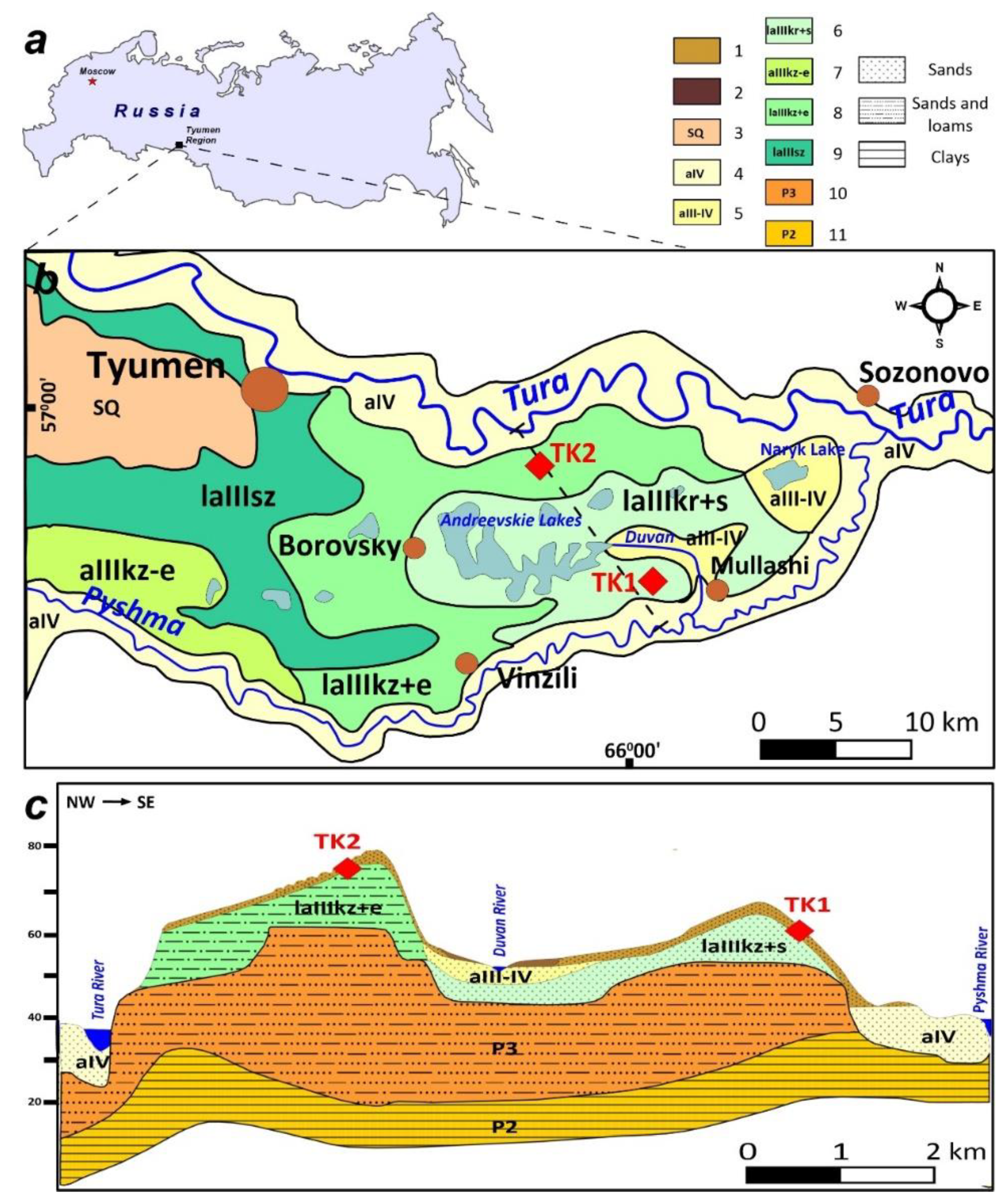
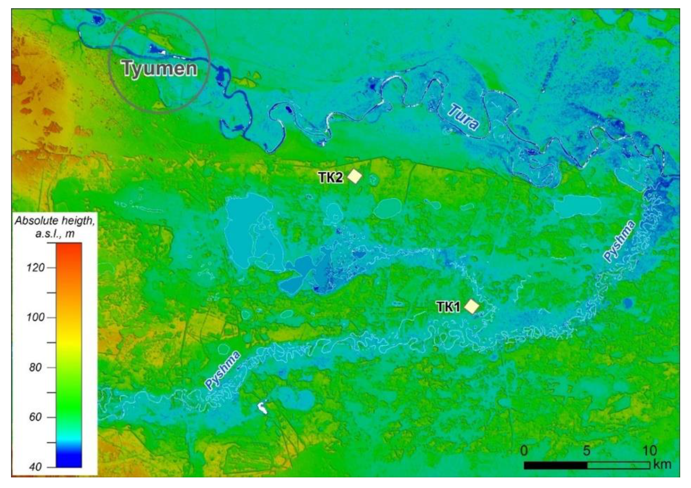
2.1. Geographical and Geological Settings

The geological and topographical context of the study area is available in Figure 1 and Figure 2. The Tura–Pyshma interfluve is a plain with absolute heights of the watersheds varying from 100 to 125 m [69] in its western part, while for the eastern part, the heights vary from 60 to 80 m [67]. A significant area within the interfluve is occupied by the fluvial terraces of the Tura and Pyshma rivers. The covering deposits of this territory are represented mainly by quaternary deposits of the Middle and Upper Pleistocene and Holocene periods. The Quaternary deposits occur on the eroded surfaces of the continental Oligocene deposits, with the exception of the floodplain area of the Pyshma River and steep slopes of the Tura River, where they lie on the Eocene clays of the Tavda Formation [70] and have a fairly diverse lithological composition and genesis. Lacustrine-alluvial, alluvial, subaerial, lacustrine-bog, and aeolian deposits are the most common deposits. The total thickness of Quaternary sediments varies from 5–20 m on river floodplains to 10–30 m on watersheds. As it is clearly visible in Figure 1a, the aeolian sandy deposits are absent according to the relevant governmental geological map [70], though they are rather common within the study area.
According to the data presented in the regional report devoted to the ecological and geological mapping of the studied territory, the aeolian landforms and deposits are widespread within the fourth, third, and second surfaces above the floodplain terraces. The largest areas with aeolian relief are confined to the peripheral areas of the Andreevskie Lakes, with the surface in the form of oriented dunes with thicknesses of aeolian deposits up to 4–5 m [67].
The modern climate of the territory is continental, with the significant influence of the western transfer of air masses. The average annual air temperature is 0.7 °C and the annual precipitation is 524 mm. The zonal hemiboreal forests of the watersheds and high terraces, covered with subaerial loess-like loams, are significantly transformed due to agricultural activities and urbanization. The vegetation of the areas covered with aeolian sandy deposits is represented by pine forests. Long-term pine forests are quite rare and pine forest plantations are widespread, due to high anthropogenic load, clear cuttings, and frequent fires. The most common soils within the areas covered with aeolian sands are Arenosols: Brunic Arenosols appear in interdune depressions or when coversands are underlined by loams, whereas Albic Arenosols predominate on steep slopes and on top of dunes [71].

2.2. Study Sites and Sampling

The field expeditions, which took place in the field seasons 2015–2018, included sequential examination of natural and anthropogenic outcrops (sand quarries), as well as route studies within the territory of the Tura–Pyshma interfluve (Tyumen region, Russia) with pronounced aeolian relief. The field studies were based on the results of analysis of space images, regional reports, historic and topographical maps, and land surface observations with a drone. Two sections in representative outcrops (TK1 and TK2) located in old sand quarries were chosen for detailed studies (Figure 1).
The first section (TK1) was located at a distance of 1.2 km to the north of the Mullashi village (57°017′276″ N, 66°077′786″ E, absolute height 60.5 m a.s.l.). The second section (TK2) was studied in an old overgrown quarry located at a distance of 12 km to the east of Tyumen (57°098′324″ N, 65°884′395″ E, absolute height 70 m a.s.l.), which was mined in the 1970s for the supply of railway bridge construction with sand. The TK1 section is located in the southern part of the interfluve with predominance of coversands, while the TK2 section is in the northern part with well pronounced aeolian relief, represented by linear and sometimes parabolic dunes with average heights up to 10 m [54]. Therefore, the TK1 characterizes a subhorisontal surface with an aeolian sand mantle and TK2, the central section of a dune. Field studies included the lithological description of deposits, with identification of texture and sedimentation structures according to [72]. Samples for sedimentological and chemical analysis were collected by intervals from stripped walls, accompanying by the description and photographing. Sediments from the following depths were selected for detailed studies: 0.5, 1.0, 2.0, 3.0, 3.5, 4.0, and 4.5 m from the TK1 section, and 0.5, 1.0, 2.0, 2.0′ (interlayer), 3.0, 4.0, 5.0, and 5.7 m from the TK2 section.
One sample from section TK1 (depth of 3.5 m) and two samples from section TK2 (depth of 1.4 m and 3.6 m) were collected by driving 50-cm-long thick opaque plastic tubes into cleaned walls of the quarry outcrops. The walls that were chosen for infrared optically stimulated luminescence (IR-OSL) dating were homogeneous and showed no signs of post-sedimentary disturbances. Plastic tubes with samples for further studies were stored in dark and cool conditions prior to their arrival at the laboratory. All preparations and measurements were performed at the Research Laboratory for Quaternary Geochronology (RLQG) (Department of Geology, Tallinn University of Technology, Estonia). One sample of organic-rich material was collected from a lens in a bottom part of TK2 profile at a depth of 4.9 m.

2.3. Analytical Methods

Grain size analysis of sediment samples was performed on a vibrating screen Fritsch Analysette 3 Pro Vibratory Sieve Shaker (Fritsch, Germany) up to a fraction < 90 microns. The fraction < 90 μm was analyzed on an Analysette 22 laser particle analyzer (Fritsch, Germany). Texture classes are given according to the WRB [73]: very coarse sand (1000–2000 μm), coarse sand (500–1000 μm), medium sand (250–500 μm), fine sand (125–250 μm), very fine sand (63–125 μm), and silt and clay (<2–63 μm). Bulk chemical composition of sediments was analyzed using an ARL-9900XP XRF-spectrometer (Thermo Fisher Scientific, Basel, Switzerland). Loss on ignition (LOI) values were determined by igniting each sample at a temperature of 1000 °C and evaluating the weight loss.
Quartz grains from a fraction of medium sand (0.25–0.5 mm) were studied under a CM0870-T binocular microscope (Altami, Russia) according to the method developed at the Institute of Geography, Russian Academy of Sciences [74]. Investigation and photographing of grains in secondary electron imaging (SEI) mode were performed using a JSM-6510LV scanning electron microscope (JEOL, Japan) at the Analytical Center for multi-elemental and isotope research, SB RAS. The roundness of the grains was determined according to the scale suggested by L.B. Rukhin [75] and a five-grade scale suggested by A.V. Khabakov [76]. Then, roundness coefficients (Q) and the degree of surface dullness (Cm) were calculated for each sample, according to the method proposed by A.A. Velichko and S.N. Timireva [74]. The following combination of techniques is in correspondence with the procedures for the preparation and characterization of samples described by D.H. Krinsley and J.C. Doornkamp [77]. The surface shape and heterogeneity of the grains were determined visually on a gradient ranging from glossy to dulled. The same technique for the analysis of quartz were used in a number of papers devoted to the aeolian sediments in the north and south of Western Siberia [3,78,79].
Feldspar-based infrared optically stimulated luminescence (IR–OSL) dating was performed at the Research Laboratory for Quaternary Geochronology (RLQG), Department of Geology, Tallinn University of Technology according to [43]. Accelerator Mass Spectrometry (AMS) C14 dating of organic-rich material from the bottom part of TK2 section was performed at BINP SB RAS (Novosibirsk). The radiocarbon dates were calibrated using the OxCal v4.3 software [80] and the IntCal 13 calibration curve.

3. Results

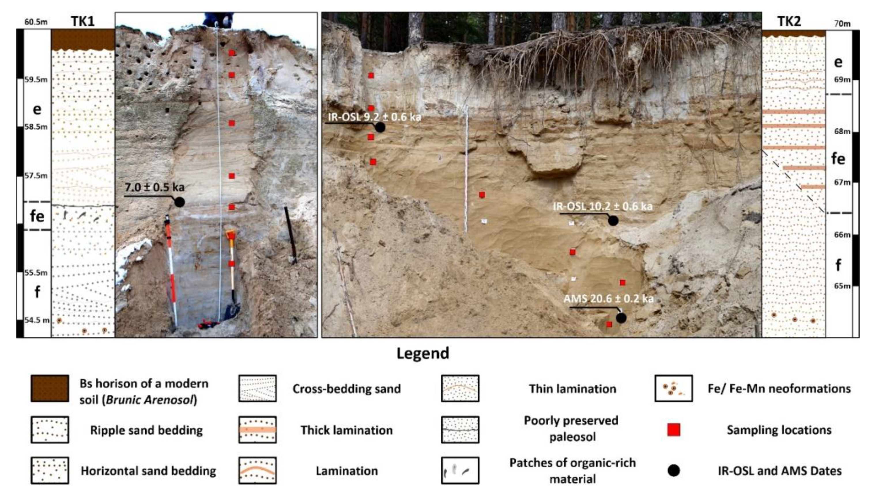
3.1. Lithological Characteristics of the Sections

The lithological scheme of the sections, with sampling intervals, is available in Figure 3 and in Appendix A.
Based on the results of field observations, it is possible to subdivide the section TK1 into several complexes:
  • The lower fluvial complex in the bottom part of the section is composed of loose fine sand with cross-stratification of medium sand and ripple thin lamination of very fine sand or silty material. Sings of ferruginization correspond mainly to the zones with well pronounced lamination, while Fe-Mn concretions are rather widespread within the whole complex;
  • The fluvio-aeolian complex in the middle part of the profile is composed of fine massive sand with thin ripple-bedded lamination of silty material in the upper part of the unit and subhorisontal lamination of coarse sand in the lower one. The contact with upper complex is pronounced by a poorly preserved buried soil, likely Albic Gleyic Arenosol, marked by the presence of small humified patches that, possibly, correspond to the [Ab] horizon which is underlined by patches of bleached material that can correspond to the [Eb] horizon. Ferruginous zones occur as separate patches within the lower part of the complex;
  • The upper aeolian complex is composed of dense fine well-sorted sands with massive structure or horizontal stratification in the upper part of the strata and climbing ripple cross-lamination or translatent stratification in the lower. Thin horizontal of ripple-bedding sediment laminae are characteristic for the most part of the complex, especially for its middle and upper parts. Laminae are likely related to modern pedogenic processes that affect the upper part of the section. The upper part of the complex is significantly disturbed by the biogenic pedoturbations, as there are clearly visible as patchy and vertical structures related to treefall related-pedoturbations and pine root channels. In general, it is possible to divide the aeolian complex into two lithofacies: the upper one with massive or horizontal stratified sand with thin well-pronounced lamination and the lower one with cross or ripple-bedded sand with less defined stratification.
In section TK2, we can also define three complexes:
  • The lower fluvial complex is composed of fine sand with very thin ripple cross-lamination of silty material and thicker ripple lamination of medium sand. The lower part of the complex contains direct signs of vanishing channel flows of sand-bed braided river and deposition in proximal zone of floodplain according to [72] and the upper part is characterized by the signs of rhythmics. The upper part of the complex also contains thin lens-like interlayers with organic-rich material;
  • The middle fluvio-aeolian complex composed of fine sand with subhorisontal very thick lamination of silty material and very thin ripple or cross lamination of coarse sand material. The complex has an uneven thickness, which is probably related with the transformation of the deposits by erosional processes. As a result, the area is characterized by the higher differences of elevation due to the pronounced dune relief. Thick lamination of this complex possibly indicates the unstable character of sedimentation during the formation of these deposits;
  • The upper aeolian complex is rather short, in comprehension with the TK1 section. It is composed with fine sands with massive structure and thin lamination. The whole complex is strongly affected by pedogenic processes, pronounced by the presence of pedogenic lamellas and biogenic pedoturbations.

3.2. Grain-Size and Bulk Chemical Composition of Studied Samples

The results of the grain-size composition analysis for both studied sections are presented in Table 1. The predominant fraction in both sections is fine sand, the content of which varies from 57.98% to 81.19% in section TK1 and from 51.71% to 72.42% in section TK2. The content of medium sand varies in the range of 8.35%–22.21% in the first section and from 10.28% to 28.86% in the second one. There is a tendency towards an increase in the proportion of medium sand in the middle and lower parts of both sections. The distribution of coarse sand with depth along the sections is non-uniform and the highest proportion of this component likely corresponds to the presence of individual interlayers with more coarse material, than with the textural properties of the whole layer, as is clearly visible in section TK2 at the depth of two meters. The fraction of very coarse sand is practically absent in the TK2 section and in the TK1 section its content was lower than 1% for all studied samples. The content of very fine sand varies significantly with depth in both sections: from 5.26% to 11.26% in the first section and from 1.74% to 17.70% in the second section. The content of silt and clay in sediments of section TK1 is very low: less than 1% for all studied samples. At the same time, in the second section (TK2), these values vary from 0.58% to 5.52%. The results of the texture analysis of sediments from the studied sections showed that section TK1 is more uniform in terms of grain-size composition. At the same time, it is important to note that middle and upper parts of both sections have high proportions of fine and very fine sand.
The results of XRF analysis of ten major oxides in the studied samples are presented in Table 2.
The high proportion SiO2 is typical for both sections. The content of SiO2 in the TK1 section is close to 90% for all studied samples, whereas in the TK2 section, these values vary in a very small range from 87.07% to 88.25%. The content of Al2O3, as well as Fe2O3, K2O, and Na2O, in sediments of section TK2, is slightly higher than that in the first section. This fact is in agreement with the results of grain-size composition analysis, which showed a higher proportion of fine fractions (silt and clay) in sediments of this section. Therefore, the higher proportion of these oxides is probably related to the higher proportion of clay minerals and feldspars. The content of CaO in sediments from both sections does not exceed 1%. In general, a uniform distribution of most oxides can be observed for both sections. At the same time, it is interesting to note that there is a small increase in the content TiO2 and CaO and a small decrease in the content of Al2O3 at a depth of 3.5 m in section TK1, and the increase in the content of Fe2O3 with depth in section TK2.
In total, we can conclude that the deposits within the studied sections are homogenous in terms of texture and major oxides distribution. These parameters are not very useful for their stratification, though the absence of contrast indirectly indicates that sources of material were rather stable and depositional process was mainly related to the reworking and redeposition of the local material.

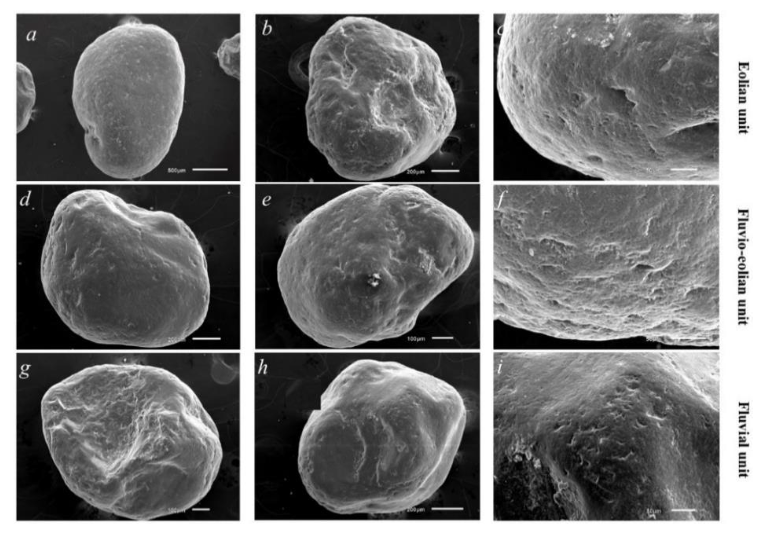
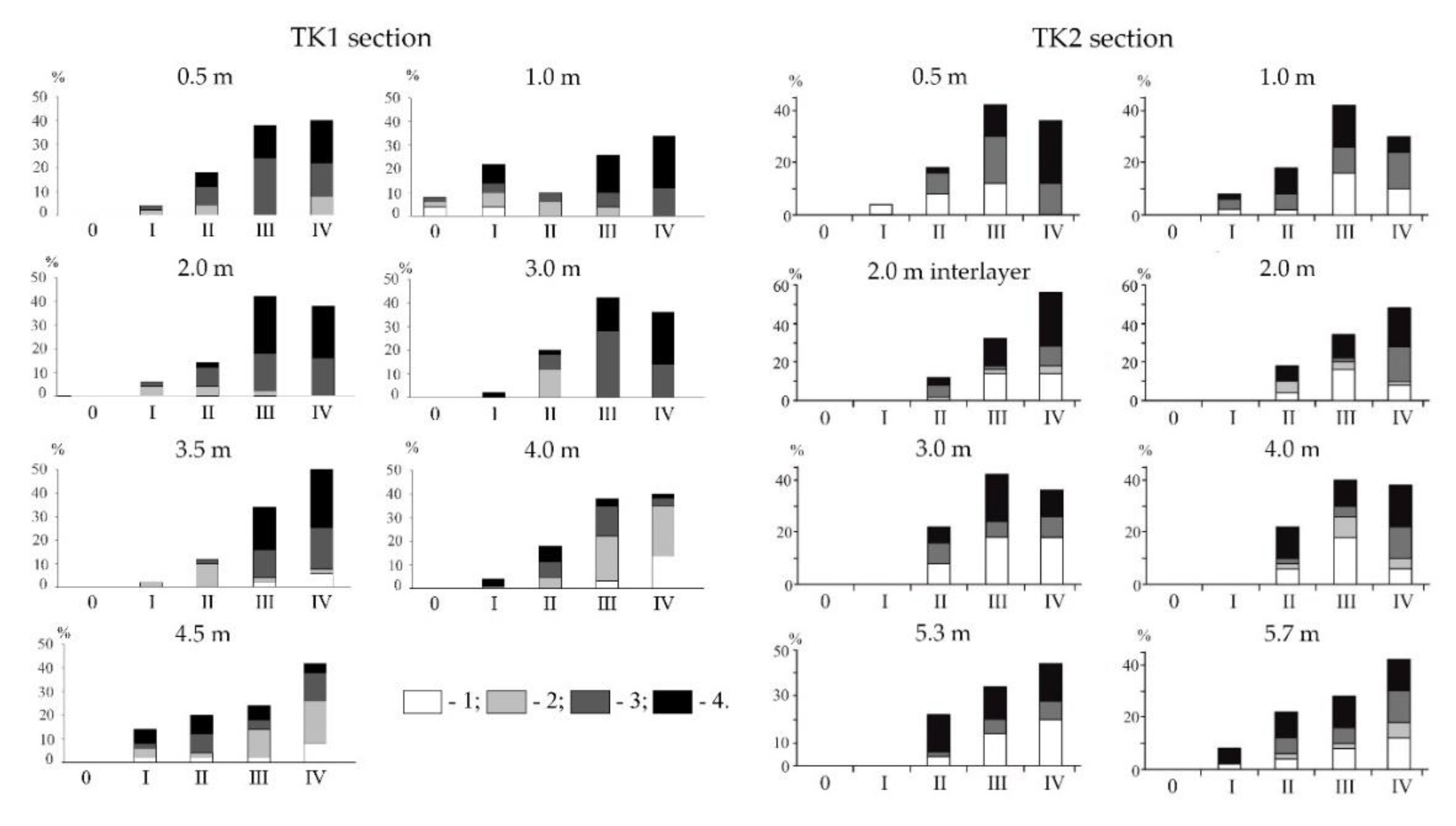
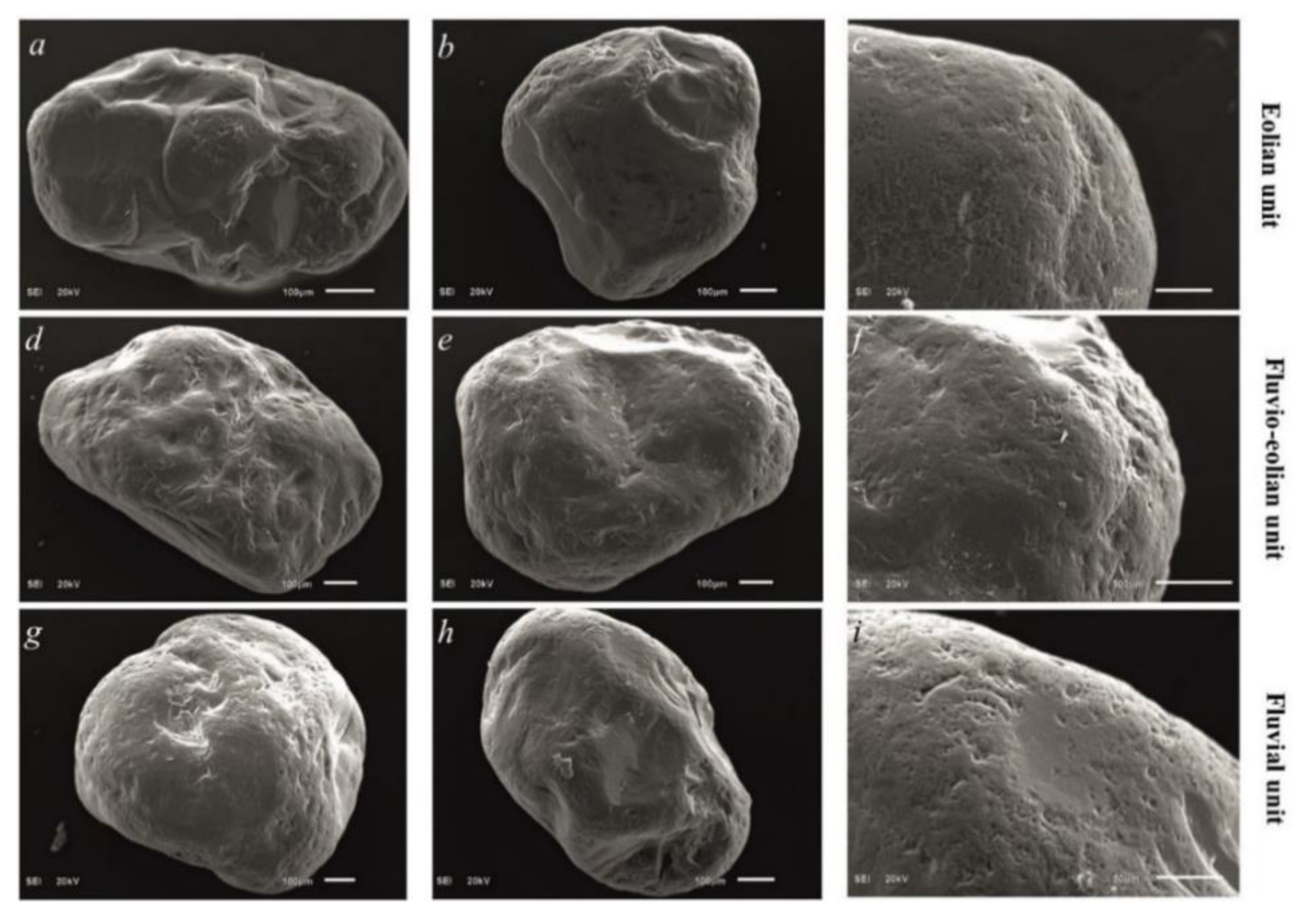
3.3. Sand Quartz Grain Morphoscopy and Morphometry

Morphometric properties of quartz sand-grains from sections TK1 and TK2 are presented in Table 3. SEM photographs of quartz grains from layers, representing different environments of the studied sections are available in Figure 4 and Figure 5.
According to the data resulting from the morphoscopy and morphometry of sand quartz grains, the deposits of the TK1 section can be conditionally subdivided into several units that formed in different sedimentary environments. The upper part of the section (depth intervals 0–3 m) was likely formed as a result of the eolian transfer of sandy material, as indicated by the high values of the roundness coefficient and the degree of dullness of grains from these layers, as well as by the presence of a micro-pitted surface on most grains and traces of mechanical interaction of grains (furrows, pits, scratches), which probably formed during their movement at high wind speeds in the near-surface layer due to saltation or drag [81,82]. Micro-pitted texture is formed as a result of grains impact with each other during the transportation in air flow [74,77]. During the post-depositional period, these sediments were subjected to relatively strong processes of chemical weathering, with many grains displaying dissolved surfaces and the etching of quartz to varying degrees in weak zones and microstructural units. The above-mentioned features are likely related to pedogenic processes [83]. The presence of such signs of fluvial transport as V-shaped and crescentic percussions and fine-pitted texture [77,81] on a number of grains, along with the observation of microwelling superimposed on them, indicate that the material was blown out of the river valley. Sand from the middle part of the strata (depth interval 3.5 m) has signs of formation under conditions of alternating depositional environments. It contains grains with signs of both fluvial and aeolian transport, as well as fluvial grains, the surface of which has been processed under air conditions. Quartz grains from the unit representing the bottom part of the section (depths of 4 and 4.5 m) have features, showing signs of fluvial processing and epigenetic weathering. The transfer of grains in water flow is indicated by the high value of the roundness coefficient, low values of the degree of dullness and the predominance of grains with glossy and quarter-matte surfaces with fine-pitted texture [84].
Therefore, we can conclude that the upper part of the section was formed under subaerial conditions, predominantly by aeolian processes, the middle part was formed in alternating depositional environments and the lower part of the section is of fluvial origin, with sediments having accumulated under conditions of a calm, slow flow.
When discussing the properties of quartz grains from section TK2, it is possible to mention that high roundness ratios, moderate degrees of dullness, the absence of untreated grains, and a low content of poorly rounded grains are typical of the entire stratum (Table 3; Figure 6).
The roundness coefficient values and the degree of roundness along the section exhibit insignificant changes. A micro-pitted surface is most characteristic of matte grains. V-shaped and crescent-shaped percussions, as well as a fine-pitted surface, are found on grains, regardless of the degree of surface dullness. Micro pits are often associated with micro-grooves. In all layers, there are signs of both aeolian transport, expressed in the form of micro-pits, often developed along protruding parts of the grains, and signs of aquatic transport in the form of a fine-pitted surface, crescent, and V-shaped depressions. In the upper part of the section (depth intervals between 0.5 and 1 m), most of the grains bear signs of transportation by wind. There is also an overlay of micro-pits on the signs of fluvial transport, though the layer was formed with a predominance of aeolian processes. The presence of grains with signs of fluvial transport is most likely associated with the close transport and input of material from the river valley [81]. Grains with signs of aeolian and fluvial processing are equally found in the middle part of the section (depth interval of 2–4 m). Based on the distribution of these microrelief elements, together with high roundness coefficient values and average values of the degree of dullness, it can be assumed that the formation of these deposits occurred in alternating fluvial/aeolian depositional environments. Despite the relatively high values of the degree of dullness and the predominance of dulled grains in the bottom of the section (depths of 5 and 5.7 m), the morphoscopy of quartz grains indicates an accumulation of deposits due to transport in a fluvial environment.

3.4. IR-OSL Dating

The IR-OSL results and radioactivity data for the samples from sections TK1 and TK2 are presented in Table 4. The age estimation of the sediments showed that the aeolian sedimentation within the study area took place in the first half of the Holocene period. In section TK1, the dating of the sediments at 3.5 m (the bottom part of the strata, formed under conditions of intensive aeolian processes) made it possible to conclude with a high degree of reliability that the sample RLOG 2444-057 7.0 ± 0.5 ka in age corresponds to the Atlantic period (8-5 cal. 14C ka BP). The IR-OSL dates from section TK2 showed that sediments from the bottom part of aeolian unit (1.4 m) have an age of 9.2 ± 0.6 ka (RLOG 2569-128), and below at a depth of 3.6 m in the layer underlining the transitional fluvio-aeolian complex, its age is 10.2 ± 0.6 ka (RLOG 2570-128). The organic-rich material from the lens in the bottom part of the profile (depth of 5.3 m) show the following AMS age estimation: 20.6 ± 0.2 ka cal BP (B1NP_NSU_1329), which corresponds to the period of last glaciation (MIS 2).

4. Discussion

4.1. Interpretation of Possible Depositional Condtions of the Studied Sections

The results of the field and analytical give us an opportunity to suggest that the studied sections are characterized by a similar structure, which was reported for other territories of periglacial Northern Eurasia with wide distributions of coversands and dune fields [38,46], as well as for the more eastern regions of the Western Siberia that correspond to the same latitude [58,65]. The deposits in the bottom parts of both sections (fluvial complex) likely reflect the conditions of water transport which is proved by the signs of rhythmics in the TK2 site, as well as by the sand quartz grain morphology. The presence of material with both singes of fluvial and aeolian transport in the bottom part TK2 can be interpreted as a result of high aeolian activity under the cold dry climate in the Periglacial zone of the Western Siberia [3]. Such conditions were favorable for deposition of material that was actively transported by wind in the river valley and its further redeposition by ephemeral and/or seasonal flow [85]. The obtained results are in good agreement with findings of aeolian material in periglacial alluvium deposits of the European region [85,86]. The middle fluvio-aeolian complex can be interpreted as alternating depositional environments [85]. As a result of quartz grains morphoscopy, it is possible to conclude that grains with signs of aeolian and fluvial processing are equally found in the transitional units of both sections. In section TK1, the border between this and upper complexes is outlined by the presence of poorly preserved paleosol, which is a good stratigraphic marker [33], that signs the start of predominantly aeolian sedimentation. Due to the low thickness and degree of preservation, its indisputable interpretation is rather difficult. The deposits in the middle complex of the TK1 section have signs of gleiing and periodic water-logging (ferruginous patches, Fe-Mn nodules), while the deposits in the middle complex of the TK2 section represent alternation of phases with predominantly aeolian deposition of more fine material and episodic phases of subaquatic sedimentation under conditions of shallow flows. The upper aeolian complexes, though they significantly differ in terms of thickness, are both composed of massive well-sorted sands with thin lamination. The quartz grains of these complexes are characterized by high values of the roundness coefficient and the degree of dullness, which is typical for aeolian sandy deposits [74].
It is important to mention that although both sections characterize fluvio-aeolian successions, the thicknesses of individual complexes; the age estimates, marking the activation of aeolian activity; as well as the textural features of sediments, representing two studied sections show some differences. These discrepancies are likely explained by the peculiarities of the geomorphology and topography of the Tura–Pyshma interfluve. The southern part of the interfluve is characterized by significantly smaller absolute heights. Therefore, this territory is strongly affected by the fluvial process of the Pyshma and Duvan rivers, as well as by the water level oscillations of the Andreevskie Lakes. Thus, it is possible to suggest that aeolian sedimentation became predominant in the higher northern part of the interfluve earlier during the Boreal period, and much later for the southern, lower part of the interfluve within the fluvial terraces of the Pyshma River. The presence of grains, with signs of fluvial transport in the deposits of the aeolian complex of the TK2 section, indirectly indicates that aeolian sedimentation in the beginning of the Holocene affected well-drained areas with high absolute heights, although fluvial processes were predominant within a large territory.

4.2. Comprehension of the Obtained Results with Data for Europian Region and Local Paleogeographical Reconstructions

The study results showed that there were two periods of aeolian activity within the study territory: one during the Boreal period, and the other, characteristic of the peripheral parts of the interfluve, during the Atlantic period. The first period is probably related to the main phase of intensive aeolian activity that took place with some regional variances in Central and Eastern Europe during the Younger Dryas, Preborial and the beginning of the Boreal periods [37,87] and in the Tomsk Priobye region in Western Siberia [65]. In the eastern sector of the Western Siberia, this phase probably began earlier, because of significant differences in the topography (absolute heights) and air mass circulation. The second “local” period of aeolian activity, related to the Atlantic period, was much less pronounced in Europe, where it corresponded to a period of dune stabilization. Furthermore, some studies mention phases of moderate aeolian activity during this time [88]. Aeolian sedimentation during the Atlantic period probably occupied relatively small areas near river valleys, during a relatively short time in the middle of that period. Therefore, this ‘local’ phase of aeolian sedimentation did not result in the formation of large dune fields. This can also be explained as a consequence of previous high-water levels and a humid climate during the early Atlantic period, which resulted in the accumulation of large amounts of fluvial sandy material within the floodplain, as well as the further draining of these surfaces during a short period of climate aridization or due to intensive meandering of rivers.
The study results are in good agreement with regional paleogeographical reconstructions developed on the basis of the cores taken from lacustrine sediments of Lake Kyrtyma and peat deposits of Oshukovskoe bog [89]. According to this research, the first phase of aeolian activity corresponded to warming conditions and a gradual decrease in moisture during the Boreal period (10.2-9.2 cal. 14C ka BP) and the second phase corresponded to a period with warm conditions, an unstable moisture regime with drying-out conditions and tendency towards shallowing water bodies [89].
The obtained results give an opportunity to rethink the distribution of aeolian deposits in the SE of Western Siberia. At the same time, accurate conclusions on the chronology of fluvio-aeolian successions and existing sedimentary environments require high-resolution dating of a number of sections and more specialized sedimentological studies.

5. Conclusions

The following statements can be considered as the main results of the study:
  • Aeolian sandy sediments are a significant component of the Late Quaternary strata within the Tura–Pyshma interfluve, although they are not mentioned on regional geological maps.
  • Aeolian sedimentation within the study area played a major role in the process of relief formation during the Early Holocene. Moreover, in terms of the accumulation of material over the entire area of the territory under consideration, the role of aeolian processes was significant.
  • The sedimentary successions of both studied sites have a threshold structure: aeolian, fluvio-aeolian, and fluvial complexes, which is supported by the results of sedimentological studies. At the same time, there are differences in the thickness of individual complexes and their sedimentary features between the studied sections, which are likely related to the differences in the geomorphological context of these sites.
  • Active processes of aeolian sedimentation within the study area were observed in the Holocene period. There are at least two periods of aeolian activity: 10.2–9.2 ka, in the Boreal period, and at nearly 7 ka, during the Atlantic period. In this area, the study results are in good agreement with the results of local paleogeographic reconstructions based on the investigations of lacustrine and peat cores.
  • The timing of the aeolian activity within the study turned out to be significantly younger than previously thought. This fact should be considered in local archeological and paleoecological reconstructions.

Author Contributions

O.S. designed the study, performed field work and sampling; O.S. and A.K. wrote the paper; A.K. was responsible for research conceptualization; A.V. performed sedimentological and geochemical studies and analyzed the obtained data, A.M. performed OSL dating and analyzed the obtained data. All authors have read and agreed to the published version of this manuscript.

Funding

Field studies were funded by RFBR and Yamal-Nenets Autonomous District, project number 19-45-890008. The research work of A.K. was funded by RFBR, project number 20-04-00836. The work was also done on state assignment of IGM SB RAS.

Conflicts of Interest

The authors declare no conflict of interest.

Appendix A

Table A1. Brief lithological characteristic of studied sections.
LayerThickness, cmLithological Description
TK1
10–40Thin Bw/Bc horizon of a modern soil (Brunic Arenosol)
240–85Brownish medium-grained loose sand with horizontal layering and thin lamellas
385–170Brownish medium-grained loose sand with horizontal or curvy layering and ferruginous interlayers
4170–230Brownish grey medium-grained dense sand with horizontal or cross-bedding and well-pronounced ferruginous interlayers
5230–345Brownish grey medium-grained dense sand with horizontal or cross-bedding
6345–367Brownish grey medium-grained loose sand with no pronounced lamination, heterogeneous due to ferruginous patches and interlayers with organic-rich material
7367–425Glaucescent brownish grey medium-grained dense sand with interlayers of coarse-grained sand and horizontal layering. Heterogeneous due to ferruginous patches, nodules and interlayers with organic-rich material.
8425–500Glaucescent grey medium-grained dense sand with horizontal layering or cross-bedding. Heterogeneous due to ferruginous patches and nodules
TK2
10–20Bw horizon of a modern soil (Brunic Arenosol)
220–60Light brown fine-grained sand with thin horizontal layering, remnants of roots, organic-rich patches (Cox horizon of Brunic Arenosol)
360–130 (360)Brownish fine-grained loose layered dense sand with interlayers of dense ferruginous sand 2 cm thick
4130–240 (360)Brownish fine-grained loose layered dense sand with light brown and dark brown dense thick interlayers
5240–560Light brown fine-grained sand with curvy bedding and interlayers of medium-grained sand and manganese neoformations. Lenses with organic-rich material
6560–595Light brown fine-grained loose sand with curvy bedding and interlayers of medium-grained sand

References

  1. Koster, E.A. Ancient and modern cold-climate aeolian sand deposition: A review. J. Quat. Sci. 1988, 3, 69–83. [Google Scholar] [CrossRef]
  2. Zeeberg, J. The European sand belt in eastern Europe and comparison of Late Glacial dune orientation with GCM simulation results. Boreas 1998, 27, 127–139. [Google Scholar] [CrossRef]
  3. Velichko, A.; Timireva, S.; Kremenetski, K.; Macdonald, G.; Smith, L. West Siberian Plain as a late glacial desert. Quat. Int. 2011, 237, 45–53. [Google Scholar] [CrossRef]
  4. Zykina, V.S.; Zykin, V.S. Loess-Soil Sequence and Environment and Climate Evolution of the Western Siberia in the Pleistocene; Geo: Novosibirsk, Russia, 2012. (In Russian) [Google Scholar]
  5. Bateman, M.D.; Thomas, D.S.; Singhvi, A.K. Extending the aridity record of the Southwest Kalahari: Current problems and future perspectives. Quat. Int. 2003, 111, 37–49. [Google Scholar] [CrossRef] [Green Version]
  6. Lancaster, N.; Kocurek, G.; Singhvi, A.; Pandey, V.; Deynoux, M.; Ghienne, J.F.; Lô, K. Late Pleistocene and Holocene dune activity and wind regimes in the western Sahara Desert of Mauritania. Geology 2002, 30, 991–994. [Google Scholar] [CrossRef]
  7. Schmeisser, R.L.; Loope, D.B.; Mason, J.A. Modern and late Holocene wind regimes over the Great Plains (central U.S.A.). Quat. Sci. Rev. 2010, 29, 554–566. [Google Scholar] [CrossRef] [Green Version]
  8. Kalińska, E.; Kot, R.; Krievāns, M. Adding Another Piece to NE European Aeolian Sand Belt Puzzles: A Sedimentary Age Case Study of Pērtupe Site, Eastern Latvia. Baltica 2020, 33, 46–57. [Google Scholar] [CrossRef]
  9. Drenova, A.; Timireva, S.; Chikolini, N. Late glacial dune-building in the Russian plain. Quatern. Int. 1997, 41–42, 59–66. [Google Scholar] [CrossRef]
  10. Kasse, C. Cold-Climate Aeolian Sand-Sheet Formation in Northwestern Europe (c. 14–12.4 ka); A Response to Permafrost Degradation and Increased Aridity. Permafr. Periglac. 1997, 8, 295–311. [Google Scholar] [CrossRef]
  11. Koster, E.A. Terminology and Lithostratigraphic Division of (Surficial) Sandy Aeolian Deposits in The Netherlands: An Evaluation. Geol. En Mijnb. Delft 1982, 61, 121–129. [Google Scholar]
  12. Koster, E. Recent advances in luminescence dating of Late Pleistocene (Cold-Climate) aeolian sand and loess deposits in western Europe. Permafr. Periglac. 2005, 16, 131–143. [Google Scholar] [CrossRef]
  13. Koster, E.A. The “European Aeolian Sand Belt”: Geoconservation of Drift Sand Landscapes. Geoheritage 2009, 1, 93–110. [Google Scholar] [CrossRef] [Green Version]
  14. Bateman, M.D.; Murton, J.B.; Crowe, W. Late Devensian and Holocene depositional environments associated with the coversand around Caistor, north Lincolnshire, UK. Boreas 2008, 29, 1–15. [Google Scholar] [CrossRef]
  15. Kasse, C. (Kees) Sandy aeolian deposits and environments and their relation to climate during the Last Glacial Maximum and Lateglacial in northwest and central Europe. Prog. Phys. Geogr. 2002, 26, 507–532. [Google Scholar] [CrossRef]
  16. Van Mourik, J.; Nierop, K.; Vandenberghe, D. Radiocarbon and optically stimulated luminescence dating based chronology of a polycyclic driftsand sequence at Weerterbergen (SE Netherlands). CATENA 2010, 80, 170–181. [Google Scholar] [CrossRef] [Green Version]
  17. Van Mourik, J.; Seijmonsbergen, A.; Slotboom, R.; Wallinga, J. Impact of human land use on soils and landforms in cultural landscapes on aeolian sandy substrates (Maashorst, SE-Netherlands). Quat. Int. 2012, 265, 74–89. [Google Scholar] [CrossRef]
  18. Bertran, P.; Bateman, M.D.; Hernandez, M.; Mercier, N.; Millet, D.; Sitzia, L.; Tastet, J.P. Inland aeolian deposits of south-west France: Facies, stratigraphy and chronology. J. Quat. Sci. 2011, 26, 374–388. [Google Scholar] [CrossRef]
  19. Vandenberghe, D.; Derese, C.; Kasse, C.; Haute, P.V.D. Late Weichselian (Fluvio-) Aeolian sediments and Holocene drift-sands of the classic type locality in Twente (E Netherlands): A high-resolution dating study using optically stimulated luminescence. Quat. Sci. Rev. 2013, 68, 96–113. [Google Scholar] [CrossRef]
  20. Beerten, K.; Vandersmissen, N.; Deforce, K.; Vandenberghe, N. Late Quaternary (15 ka to present) development of a sandy landscape in the Mol area, Campine region, North-East Belgium. J. Quat. Sci. 2014, 29, 433–444. [Google Scholar] [CrossRef]
  21. Beerten, K.; Leterme, B. Palaeohydrological reconstruction (1500–2000AD) of a drift sand landscape using pedogeomorphological and historical data (Campine Area, NE Belgium). CATENA 2015, 135, 208–218. [Google Scholar] [CrossRef]
  22. Beerten, K.; Heyvaert, V.; Vandenberghe, D.A.; Van Nieuland, J.; Bogemans, F. Revising the Gent Formation: A new lithostratigraphy for Quaternary wind-dominated sand deposits in Belgium. Geol. Belg. 2017, 20, 95–102. [Google Scholar] [CrossRef] [Green Version]
  23. Sitzia, L.; Bertran, P.; Bahain, J.-J.; Bateman, M.D.; Hernandez, M.; Garon, H.; De Lafontaine, G.; Mercier, N.; Leroyer, C.; Queffelec, A.; et al. The Quaternary coversands of southwest France. Quat. Sci. Rev. 2015, 124, 84–105. [Google Scholar] [CrossRef]
  24. Pierik, H.J.; Van Lanen, R.J.; Gouw-Bouman, M.T.; Groenewoudt, B.J.; Wallinga, J.; Hoek, W.Z. Controls on late-Holocene drift-sand dynamics: The dominant role of human pressure in the Netherlands. Holocene 2018, 28, 1361–1381. [Google Scholar] [CrossRef] [PubMed]
  25. Sevink, J.; Van Geel, B.; Jansen, B.; Wallinga, J. Early Holocene forest fires, drift sands, and Usselo-type paleosols in the Laarder Wasmeren area near Hilversum, the Netherlands: Implications for the history of sand landscapes and the potential role of Mesolithic land use. CATENA 2018, 165, 286–298. [Google Scholar] [CrossRef]
  26. Crombé, P.; Bos, J.A.A.; Cruz, F.; Verhegge, J. Repeated aeolian deflation during the Allerød/GI-1a-c in the coversand lowland of NW Belgium. CATENA 2020, 188, 104453. [Google Scholar] [CrossRef]
  27. Kolstrup, E.; Jørgensen, J.B. Older and Younger Coversand in Southern Jutland (Denmark). Bull. Geol. Soc. Den. 1982, 30, 71–77. [Google Scholar]
  28. Hilgers, A.; Murray, A.; Schlaak, N.; Radtke, U. Comparison of Quartz OSL protocols using Lateglacial and Holocene dune sands from Brandenburg, Germany. Quat. Sci. Rev. 2001, 20, 731–736. [Google Scholar] [CrossRef]
  29. Hilgers, A. The Chronology of Late Glacial and Holocene Dune Development in the Northern Central European Lowland Reconstructed by Optically Stimulated Luminescence (OSL) Dating. Ph.D. Thesis, University of Cologne, Cologne, Germany, October 2007. [Google Scholar]
  30. Kolstrup, E. OSL Dating in Palaeoenvironmental Reconstructions. A Discussion from A User’s Perspective. Est. J. Earth Sci. 2007, 56, 157–166. [Google Scholar]
  31. Kolstrup, E. Lateglacial older and younger coversand in northwest Europe: Chronology and relation to climate and vegetation. Boreas 2007, 36, 65–75. [Google Scholar] [CrossRef]
  32. Kolstrup, E.; Murray, A.; Possnert, G. Luminescence and radiocarbon ages from laminated Lateglacial aeolian sediments in western Jutland, Denmark. Boreas 2007, 36, 314–325. [Google Scholar] [CrossRef]
  33. Kaiser, K.; Hilgers, A.; Schlaak, N.; Jankowski, M.; Kühn, P.; Bussemer, S.; Przegietka, K. Palaeopedological marker horizons in northern central Europe: Characteristics of Lateglacial Usselo and Finow soils. Boreas 2009, 38, 591–609. [Google Scholar] [CrossRef]
  34. Kaiser, K.; Schneider, T.; Küster, M.; Dietze, E.; Fülling, A.; Heinrich, S.; Kappler, C.; Nelle, O.; Schult, M.; Theuerkauf, M.; et al. Palaeosols and their cover sediments of a glacial landscape in northern central Europe: Spatial distribution, pedostratigraphy and evidence on landscape evolution. CATENA 2020, 193, 104647. [Google Scholar] [CrossRef]
  35. Tolksdorf, J.F.; Kaiser, K.; Terberger, T.; Klasen, N.; Schneider, B.; Masberg, P. Aeolian sedimentation in the Rhine and Main area from the Late Glacial until the Mid-Holocene: New evidence from the Magdalenien site of Götzenhain (Hesse, Germany). Quat. Sci. J. 2011, 59, 36–43. [Google Scholar] [CrossRef]
  36. Jankowski, M. Lateglacial soil paleocatena in inland-dune area of the Toruń Basin, Northern Poland. Quat. Int. 2012, 265, 116–125. [Google Scholar] [CrossRef]
  37. Tolksdorf, J.F.; Kaiser, K. Holocene aeolian dynamics in the European sand-belt as indicated by geochronological data. Boreas 2012, 41, 408–421. [Google Scholar] [CrossRef]
  38. Zieliński, P.; Sokołowski, R.J.; Fedorowicz, S.; Zaleski, I. Periglacial structures within fluvio-aeolian successions of the end of the Last Glaciation—Examples from SE Poland and NW Ukraine. Boreas 2014, 43, 712–721. [Google Scholar] [CrossRef]
  39. Zieliński, P.; Sokołowski, R.J.; Jankowski, M.; Standzikowski, K.; Fedorowicz, S. The climatic control of sedimentary environment changes during the Weichselian—An example from the Middle Vistula Region (Eastern Poland). Quatern. Int. 2019, 501, 120–134. [Google Scholar] [CrossRef]
  40. Küster, M.; Fülling, A.; Kaiser, K.; Ulrich, J. Aeolian sands and buried soils in the Mecklenburg Lake District, NE Germany: Holocene land-use history and pedo-geomorphic response. Geomorphology 2014, 211, 64–76. [Google Scholar] [CrossRef]
  41. Kruczkowska, B.; Błaszkiewicz, M.; Jonczak, J.; Uzarowicz, Ł.; Moska, P.; Brauer, A.; Bonk, A.; Słowiński, M. The Late Glacial pedogenesis interrupted by aeolian activity in Central Poland—Records from the Lake Gościąż catchment. CATENA 2020, 185, 104286. [Google Scholar] [CrossRef]
  42. Markov, K.K. Ancient inland dunes of Europe. Priroda 1928, 6, 554–574. [Google Scholar]
  43. Molodkov, A.; Bitinas, A. Sedimentary record and luminescence chronology of the Lateglacial and Holocene aeolian sediments in Lithuania. Boreas 2006, 35, 244–254. [Google Scholar] [CrossRef]
  44. Drenova, A.N. Ancient Continental Dunes in the Upper Volga Basin: Their Orientation, Structure, Granulometric Composition. Geomorphologya 2011, 1, 37–48. [Google Scholar] [CrossRef]
  45. Kalińska-Nartiša, E.; Nartišs, M.; Thiel, C.; Buylaert, J.-P.; Murray, A.S. Late-glacial to Holocene aeolian deposition in northeastern Europe—The timing of sedimentation at the Iisaku site (NE Estonia). Quatern. Int. 2015, 357, 70–81. [Google Scholar] [CrossRef]
  46. Kalińska-Nartiša, E.; Thiel, C.; Nartišs, M.; Buylaert, J.-P.; Murray, A.S. Age and sedimentary record of inland eolian sediments in Lithuania, NE European Sand Belt. Quatern. Res. 2015, 84, 82–95. [Google Scholar] [CrossRef]
  47. Kalińska-Nartiša, E.; Dzierżek, J.; Bińka, K.; Borkowski, A.; Rydelek, P.; Zawrzykraj, P. Upper Pleistocene palaeoenvironmental changes at the Zwierzyniec site, Central Poland. Geol. Q. 2016, 60, 610–623. [Google Scholar] [CrossRef]
  48. Kalińska-Nartiša, E.; Thiel, C.; Nartišs, M.; Buylaert, J.-P.; Murray, A.S. The north-eastern aeolian ‘European Sand Belt’ as potential record of environmental changes: A case study from Eastern Latvia and Southern Estonia. Aeolian Res. 2016, 22, 59–72. [Google Scholar] [CrossRef] [Green Version]
  49. Drenova, A.N.; Velichko, A.A. Ancient Continental Dunes of Eastern Europe (Their Distribution, Age, Direction of Dune-Forming Winds). In Pathways of Evolutionary Geography, Proceedings of the All-Russian Scientific Conference Dedicated to the Memory of Professor A.A.; Velichko, Moscow, Russia, 23–25 November 2016; Institute of Geography RAS: Moscow, Russia, 2016; pp. 81–87. (In Russian) [Google Scholar]
  50. Seppälä, M. Location, Morphology and Orientation of Inland Dunes in Northern Sweden. Geogr. Ann. A 1972, 54, 85–104. [Google Scholar] [CrossRef]
  51. Alexanderson, H.; Bernhardson, M. OSL dating and luminescence characteristics of aeolian deposits and their source material in Dalarna, central Sweden. Boreas 2016, 45, 876–893. [Google Scholar] [CrossRef]
  52. Bernhardson, M.; Alexanderson, H.; Björck, S.; Adolphi, F. Sand drift events and surface winds in South-Central Sweden: From the deglaciation to the present. Quat. Sci. Rev. 2019, 209, 13–22. [Google Scholar] [CrossRef]
  53. Berg, L.S. Ancient Continental Dunes of Eurasia. Priroda 1928, 2, 171–172. (In Russian) [Google Scholar]
  54. Astapov, A.P.; Bazanov, A.A.; Mingaleva, V.A. Geological Structure of the Southern Part of the Tyumen Region (A Summary Report of the Ishim Party on the Results of Integrated Geological and Hydrogeological Survey Work on a Scale of 1:200,000; Sheets O-42-B and O-42-G Western 2/3; TKGRE: Tyumen, Russia, 1964. (In Russian) [Google Scholar]
  55. Evseeva, N.S.; Zemtsov, A.A. Relief Formation in the Forest-Bog Zone of the Western Siberian Plain; Tomsk State University Publ.: Tomsk, Russia, 1990. (In Russian) [Google Scholar]
  56. Maloletko, A.M. The Evolution of River Systems in Western Siberia in the Mesozoic and Cenozoic; Tomsk State University Publ.: Tomsk, Russia, 2008. (In Russian) [Google Scholar]
  57. Luzgin, B.N. Paragenetic Relations of Alluvial and Aeolian Processes in The Upper Ob Region. Geogr. I Prirodopolz. Sib. 2009, 11, 149–161. (In Russian) [Google Scholar]
  58. Parnachev, V.P.; Parnachev, S.V. Geology and Minerals of the Surroundings of the City of Tomsk: Materials for the Field Geological Excursion: Reference Book; Tomsk State University Publ.: Tomsk, Russia, 2010. (In Russian) [Google Scholar]
  59. Sizov, O.S.; Zimina, O.Y. Particulars of a Life Support System and Spatial Distribution Regarding Settlements of the Itkul Culture in the Low Tobol Basin (VIII–VI cc. BC). Vestnik Archeologii Antropologii Etnografii 2012, 4, 150–159. (In Russian) [Google Scholar]
  60. Kulizhsky, S.; Loiko, S.; Konstantinov, A.; Krickov, I.V.; Istigechev, G.; Lim, A.G.; Kuzmina, D. Lithological sequence of soil formation on the low terraces of the Ob and the Tom rivers in the south of Tomsk Oblast. Int. J. Environ. Stud. 2015, 72, 1037–1046. [Google Scholar] [CrossRef]
  61. Galanin, A.A.; Pavlova, M.R.; Klimova, I.V. Late Quaternary Dune Formations (D’olkuminskaya Series) In Central Yakutia (Part 1). Kriosf. Zemli 2018, 22, 3–15. [Google Scholar] [CrossRef]
  62. Ryabukha, A. Late pleistocene periglacial formations in landscapes of Zavolzhye-Urals region. IOP Conf. Series Earth Environ. Sci. 2018, 201, 12018. [Google Scholar] [CrossRef]
  63. Galanin, A.A.; Pavlova, M.R. Late Quaternary dune formations (D’olkuminskaya Series) in Central Yakutia (Part 2). Kriosf. Zemli 2019, 23, 3–16. [Google Scholar] [CrossRef]
  64. Golubtsov, V.A.; Khokhlova, O.S.; Cherkashina, A.A. Carbonate Rhizoliths in Dune Sands of the Belaya River Valley (Upper Angara Region). Eurasian Soil Sci. 2019, 52, 83–93. [Google Scholar] [CrossRef]
  65. Konstantinov, A.; Loiko, S.; Kurasova, A.O.; Konstantinova, E.; Novoselov, A.; Istigechev, G.; Kulizhskiy, S.P. First Findings of Buried Late-Glacial Paleosols within the Dune Fields of the Tomsk Priobye Region (SE Western Siberia, Russia). Geosciences 2019, 9, 82. [Google Scholar] [CrossRef] [Green Version]
  66. Lancaster, N.; Wolfe, S.; Thomas, D.S.; Bristow, C.S.; Bubenzer, O.; Burrough, S.L.; Duller, G.; Halfen, A.; Hesse, P.; Roskin, J.; et al. The INQUA Dunes Atlas chronologic database. Quatern. Int. 2016, 410, 3–10. [Google Scholar] [CrossRef]
  67. Anufrieva, L.I.; Shiverskikh, I.A.; Krivenkova, G.G. Ecological-Geological Mapping of a Scale of 1:200,000 Territory of Sheets O-41-XXIV, XXX. Report of the Eastern Ecological Geological Survey for the Years 1993–2001: Geological Report; ZAO TKGRE: Tyumen, Russia, 2001. (In Russian) [Google Scholar]
  68. Zimina, O.; Zherebyatyeva, N.; Idrisov, I.; Sizov, O.; Moskvina, N.; Afonin, A.; Ivanov, S.; Ryabogina, N. The Andreevskoye Lake System at The Turn of The Bronze and Early Iron Ages: Paleo-Landscape Mapping, Bioproductivity Assessment and Demographic Capacity of The Territory (Tura and Pyshma Interfluve, West Siberia). Vestn. Arheol. Antropol. I Etnogr. 2019, 2, 69–84. [Google Scholar] [CrossRef]
  69. Glavnoe Upravlenie Geodezii i Kartografii. Atlas Tyumenskoj Oblasti; Glavnoe Upravlenie Geodezii i Kartografii: Moscow/Tyumen, Russia, 1971. (In Russian) [Google Scholar]
  70. Vsegei Fgup. State Geological Map of Russia. Scale 1:1000000 (3rd Generation). Ural. O-41 (Ekaterinburg); Vsegei Fgup: Moscow, Russia, 2011. [Google Scholar]
  71. Konstantinov, A.; Loyko, S.; Kurasova, A.; Kulizhskiy, S. Common Factors of the Lithological-Geomorphological Organization of Soil Cover of the Sand Massives of the South of Western Siberia. Adv. Curr. Nat. Sci. 2018, 7, 151–156. [Google Scholar] [CrossRef] [Green Version]
  72. Zieliński, P.; Sokołowski, R.J.; Fedorowicz, S.; Jankowski, M. Stratigraphic position of fluvial and aeolian deposits in the Żabinko site (W Poland) based on TL dating. Geochronometria 2011, 38, 64–71. [Google Scholar] [CrossRef] [Green Version]
  73. IUSS Working Group WRB. World Reference Base of Soil Resources 2014, Update 2015. International Soil Classification System for Naming Soils and Creating Legends for Soil Maps. World Soil Resources Reports No. 106; FAO: Rome, Italy, 2015; p. 192. [Google Scholar]
  74. Velichko, A.A.; Timireva, S.N. Morphoscopy and morphometry of quartz grains from 608 loess and buried soil layers. GeoJournal 1995, 36, 143–149. (In Russian) [Google Scholar] [CrossRef]
  75. Rukhin, L.B. Fundamentals of Lithology. Doctrine of Sedimentary Rocks; Nedra: Leningrad, Russia, 1969. (In Russian) [Google Scholar]
  76. Khabakov, A.V. On Roundness Indexes of Pebble. Sov. Geol. 1946, 10, 98–99. (In Russian) [Google Scholar]
  77. Krinsley, D.H.; Doorkamp, J.C. Atlas of Quartz Sand Surface Textures; Cambridge University Press: Cambridge, UK, 1973. [Google Scholar]
  78. Sizikova, A.O.; Zykina, V. The dynamics of the Late Pleistocene loess formation, Lozhok section, Ob loess Plateau, SW Siberia. Quatern. Int. 2015, 365, 4–14. [Google Scholar] [CrossRef]
  79. Sizov, O.; Volvakh, A.; Vishnevskiy, A.; Soromotin, A.; Abakumov, E. Lithological and geomorphological indicators of glacial genesis of the upper Quaternary strata in the lower courses of the Nadym River. Solid Earth 2019. [Google Scholar] [CrossRef] [Green Version]
  80. Ramsey, C.B. Radiocarbon Calibration and Analysis of Stratigraphy: The OxCal Program. Radiocarbon 1995, 37, 425–430. [Google Scholar] [CrossRef] [Green Version]
  81. Vos, K.; Vandenberghe, N.; Elsen, J. Surface textural analysis of quartz grains by scanning electron microscopy (SEM): From sample preparation to environmental interpretation. Earth Sci. Rev. 2014, 128, 93–104. [Google Scholar] [CrossRef]
  82. Woronko, B.; Dłużewski, M. Sand-grain micromorphology used as a sediment-source indicator for Kharga Depression dunes (Western Desert, S Egypt). Aeolian Res. 2017, 29, 42–54. [Google Scholar] [CrossRef]
  83. Wilson, M.J. Dissolution and formation of quartz in soil environments: A review. Soil Sci. Annu. 2020, 71, 3–14. [Google Scholar] [CrossRef]
  84. Mycielska-Dowgiałło, E.; Woronko, B. Analiza Obtoczenia I Zmatowienia Powierzchni Ziarn Kwarcowych Frakcji Piaszczystej I Jej Wartość Interpretacyjna. Przegląd Geol. 1998, 46, 1275–1281. [Google Scholar]
  85. Zieliński, P.; Sokołowski, R.J.; Woronko, B.; Fedorowicz, S.; Jankowski, M.; Standzikowski, K. Sandy deposition in a small dry valley in the periglacial zone of the Last Glacial Maximum: A case study from the Józefów site, SE Poland. Quatern. Int. 2016, 399, 58–71. [Google Scholar] [CrossRef]
  86. Sokołowski, T.; Wacnik, A.; Woronko, B.; Madeja, J. EemianWeichselian Pleniglacial fluvial deposits in S Poland (an example of the Vistula River valley in Kraków). Geol. Q. 2014, 58, 71–84. [Google Scholar] [CrossRef]
  87. Leonova, E.N. Planigraphic Analysis of the “Dune” Mesolithic Sites of The Volga-Oka Interfluve. Candidate of Historical Sciences; Institute of Archaeology RAS: Moscow, Russia, 1998. [Google Scholar]
  88. Schirmer, W. Dune Phases and Soils in The European Sand Belt. Geo. Archaeo. Rhein. 1999, 3, 11–42. [Google Scholar]
  89. Ryabogina, N.E.; Afonin, A.S.; Ivanov, S.N.; Li, H.-C.; Kalinin, P.A.; Udaltsov, S.; Nikolaenko, S.A. Holocene paleoenvironmental changes reflected in peat and lake sediment records of Western Siberia: Geochemical and plant macrofossil proxies. Quatern. Int. 2019, 528, 73–87. [Google Scholar] [CrossRef]
Figure 1. Location of the study sites: (a) within the territory of Russia; (b) on the simplified map of quaternary deposits of the Tura–Pyshma interfluve according to [70]; (c) a simplified cross section between TK1 and TK2 sites according to [67,70] with some modifications, where: 1—covering aeolian sands, 2—Holocene peat deposits; 3—poorly defined covering loess-like loamy deposits; 4—modern alluvial deposits of floodplains (aIV); 5—alluvial deposits of the first floodplain terrace (aIII-IV); 6—Late Pleistocene lacustrine and alluvial deposits of the Karginsky and Sartan horizons (laIIIkr+s); 7—Late Pleistocene alluvial deposits of the third floodplain terrace, Kazantsevky and Ermakovsky horizons (aIIIkz-e); 8—Late Pleistocene lacustrine and alluvial deposits of the Kazantsevky and Ermakovsky horizons (aIIIkz+e); 9—Middle Pleistocene lacustrine and alluvial deposits of the Suzgunskaja sequence (laIIsz); 10—Oligocene deposits of the Turtass and Kurtamysh formations (P3); 11—Eocene deposits of the Tavda formation (P2).
Geosciences 10 00396 g001
Figure 2. Topographic image of the study area (ALOS Global Digital Surface Model (AW3D30)).
Geosciences 10 00396 g002
Figure 3. Lithological scheme of studied sections. Units: e—aeolian unit; fe—fluvio-aeolian unit; f—fluvial unit.
Geosciences 10 00396 g003
Figure 4. SEM photographs of representative quartz grains from different complexes of the TK1 section: (a) rounded matt grain with micro-pitted surface; (b) chemically weathered grain; (c) micro-pitted chemically weathered surface; (d) half-matted grain with signs of both pit and micro-pitted surface structure; (e) half-matted grain with micro-pitted surface structure and signs of mechanically induced features; (f) matte grain with signs of etching and both fine-pitted and micro-pitted surface structure; (g) half-matted etched grain with fine-pitted surface structure; (h) and (i) glossy grain with fine-pitted surface structure.
Geosciences 10 00396 g004
Figure 5. SEM photographs of representative quartz grains from different complexes of the TK2 section: (a) half-matte grain with small-pitted and micro-pitted surface structure and conchoidal fractures; (b) glossy grain with micro-pitted surface and visible traces of chemical weathering; (c) half-matte grain with fine-pitted and micro-pitted surface structure; (d) matte grain with micro-pitted surface; (e) glossy grain with V-shaped and crescentic marks; (f) surface with V-shaped and crescentic marks; (g) glossy grain with micro-pitted surface structure; (h) half-matte grain with micro-pitted surface structure and crescentic marks; (i) half-matte grain with fine-pitted surface structure and crescentic marks.
Geosciences 10 00396 g005
Figure 6. Distribution of quartz sand-grains from sections TK1 and TK2 according to roundness and dullness, where (1) is glossy, (2) is quarter matted (slightly dulled), (3) is half matted (medium dulled), (4) is matted; 0, I, II, III, IV are grades of roundness according to the scale of Khabakov [76].
Geosciences 10 00396 g006
Table 1. Grain-size composition (%) of the studied sections.
SectionDepth, mVery Coarse SandCoarse SandMedium SandFine SandVery Fine SandSilt and Clay
TK10.50.434.4316.7871.296.560.51
1.00.342.398.3581.197.640.09
2.00.154.8821.1465.038.650.17
3.00.041.0412.5675.0411.190.14
3.50.777.3122.2157.9811.260.50
4.00.696.5617.2370.205.260.08
4.50.072.5020.0566.2910.800.30
TK20.50.001.7210.2864.7717.705.52
1.00.002.2217.6672.426.141.56
2.00.0018.7626.9751.711.740.82
2.0′0.001.7425.0067.285.280.70
3.00.000.4828.1762.097.122.14
4.00.000.6620.5670.847.100.84
5.30.004.7828.8660.924.860.58
5.70.001.6828.8460.827.221.44
Table 2. Bulk chemical composition (%) of studied sections.
Depth, mSiO2Al2O3Fe2O3K2ONa2OCaOTiO2MgOMnOP2O5LOISUM
TK1 Section
0.590.074.920.741.181.000.840.220.190.020.030.4299.61
1.089.704.890.661.181.020.740.210.170.020.020.3498.95
2.090.264.760.701.141.000.770.210.170.020.030.2399.29
3.089.895.110.711.241.130.770.190.180.010.020.2999.55
3.589.694.840.701.161.090.820.330.170.020.020.3499.18
4.090.604.760.631.131.040.750.220.140.020.020.4099.70
4.589.395.140.641.291.120.770.230.160.020.020.4299.18
TK2 Section
0.587.735.890.921.381.330.890.410.230.020.030.5899.42
1.088.255.430.931.301.220.870.350.230.020.030.5799.20
2.087.495.901.241.291.110.790.310.280.030.031.0599.51
2.0′88.215.751.011.311.170.830.330.250.020.020.8099.71
3.087.565.631.031.331.150.790.330.250.030.021.0199.13
4.087.075.831.111.421.150.790.360.270.030.031.1199.16
5.387.385.841.141.421.120.790.380.270.030.030.9899.37
5.787.335.751.131.381.160.820.400.260.030.031.1099.38
Table 3. Morphometric properties of the quartz sand-grains from studied sections.
SectionDepth, mQ 1, %Cm2, %SectionDepth, mQ 1, %Cm2, %
TK10.578.565.5TK20.577.557.0
1.064.064.51.072.553.0
2.078.072.52.086.057.0
3.078.066.02.0′82.553.0
3.584.064.03.078.547.0
4.075.541.04.079.050.5
4.573.546.55.380.554.0
5.776.054.0
1 roundness coefficient; 2 degree of surface dullness.
Table 4. IR-OSL results and radioactivity data for the samples from sections TK1 and TK2.
SectionDepth, mU, ppmTh, ppmK, %P, GyIR-OSL Age, ka
TK13.50.391.400.8713.37.0 ± 0.5
TK21.40.491.851.0119.29.2 ± 0.6
TK23.60.340.771.0920.810.2 ± 0.6
U, Th, and K are the uranium, thorium, and potassium content in the sediment as determined from laboratory gamma spectrometry; P is the paleodose.

