
Addressing Groundwater Declines with Precision Agriculture: An Economic Comparison of Monitoring Methods for Variable-Rate Irrigation


Abstract
:1. Introduction
2. Materials and Methods
2.1. Methods
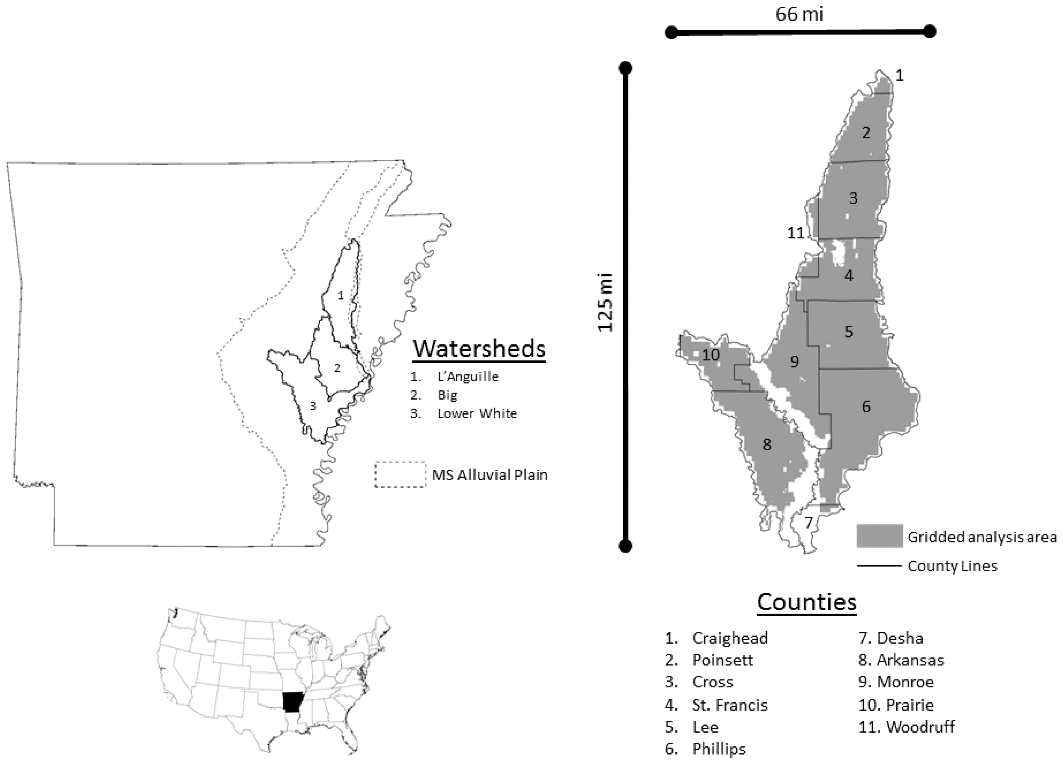
2.1.1. Land Cover
2.1.2. Irrigation
2.1.3. Profit Objective
2.1.4. Cost-Effectiveness and Net Returns per Acre-Foot of Aquifer Retention with Precision Irrigation
2.1.5. Sensitivity Analyses and Conservation Policies
2.2. Data
2.2.1. Aquifer
2.2.2. Farm Production and the On-Farm Reservoir and Tail-Water Recovery System
2.2.3. Production Cost and Water Use Factors for Remote Monitoring Technologies
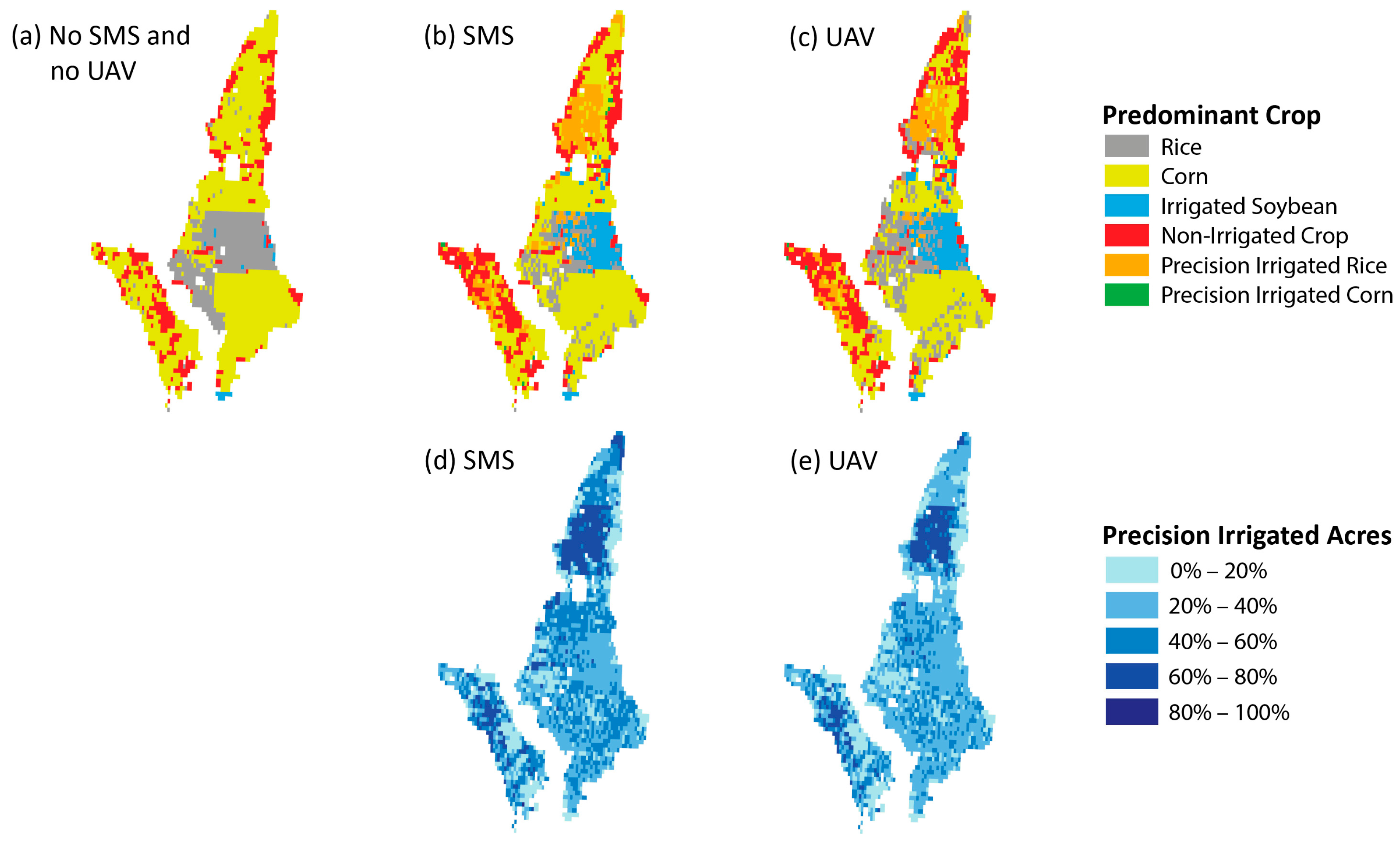
3. Results
4. Discussion
Acknowledgments
Author Contributions
Conflicts of Interest
References
- Schaible, G.; Aillery, M. Water Conservation in Irrigated Agriculture: Trends and Challenges in the Face of Emerging Demands; United States Department of Agriculture (USDA), Economic Research Service (ERS): Washington, DC, USA, 2012.
- Arkansas Water Plan Update. 2014. Available online: http://arkansaswaterplan.org/plan/ArkansasWaterPlan/Update.htm (accessed on 10 June 2016).
- Canessa, P.; Green, S.; Zoldoske, D. Agricultural Water Use in California: A 2011 Update; Staff Report; The Center for Irrigation Technology, Fresno State University: Fresno, CA, USA, 2011. Available online: http://www.waterboards.ca.gov/waterrights/water_issues/programs/hearings/cachuma/exbhts_2012feir/cachuma_feir_mu289.pdf (accessed on 2 December 2016).
- Allen, R.G.; Willardson, L.S.; Burt, C.; Clemmens, A.J. Water conservation questions and definitions from a hydrologic perspective. In Proceedings of the IA International Irrigation Show, San Diego, CA, USA, 18 November 2003.
- Snyder, R.L.; Hanson, B.R.; Coppock, R. How Farmers Irrigate in California; University of California Division of Agriculture and Nature Research: Davis, CA, USA, 1986; pp. 1–6. Available online: http://anrcatalog.ucanr.edu/pdf/21414e.pdf (accessed on 2 December 2016).
- Hedley, C.B.; Yule, I.J. Soil water status mapping and two variable-rate irrigation scenarios. Precis. Agric. 2009, 10, 342–355. [Google Scholar] [CrossRef]
- Hedley, C.B.; Yule, I.J.; Tuohy, M.P.; Vogeler, I. Key performance indicators for simulated variable-rate irrigation of variable soils in humid regions. Trans. ASABE 2009, 52, 1575–1584. [Google Scholar] [CrossRef]
- Hedley, C.B.; Bradbury, S.; Ekanayake, J.; Yule, I.J.; Carrick, S. Spatial irrigation scheduling for variable rate irrigation. In Proceedings of the New Zealand Grassland Association Conference, Lincoln, New Zealand, 15–18 November 2010; New Zealand Grassland Association: Dunedin, New Zealand, 2010; Volume 72, pp. 97–102. [Google Scholar]
- Hedley, C.B.; Yule, I.J.; Bradbury, S. Analysis of potential benefits of precision irrigation for variable soils at five pastoral and arable production sites in New Zealand. In Proceedings of the 19th World Soil Congress, Brisbane, Australia, 1–6 August 2010; pp. 1–6.
- Thrikawala, S.; Weersink, A.; Fox, G.; Kachanoski, G. Economic feasibility of variable-rate technology for nitrogen on corn. Am. J. Agric. Econ. 1999, 81, 914–927. [Google Scholar] [CrossRef]
- Zhang, M.; Li, M.; Wang, W.; Liu, C.; Gao, H. Temporal and spatial variability of soil moisture based on WSN. Math. Comput. Model. 2013, 58, 826–833. [Google Scholar] [CrossRef]
- Lowenberg-DeBoer, J. Economics of variable rate planting for corn. In Precision Agriculture; ASA, CSSA, SSSA: Madison, WI, USA, 1999; pp. 1643–1651. [Google Scholar]
- Strickland, R.M.; Ess, D.R.; Parsons, S.D. Precision farming and precision pest management: The power of new crop production technologies. J. Nematol. 1998, 30, 431–435. [Google Scholar] [PubMed]
- Peters, R.T.; Evett, S.R. Automation of a center pivot using the temperature-time-threshold method of irrigation scheduling. J. Irrig. Drain. Eng. 2008, 134, 286–291. [Google Scholar] [CrossRef]
- LaRue, J.L. Variable Rate Irrigation 2010 Field Results for Center Plains Conference. In Proceedings of the 23rd Annual Central Plains Irrigation Conference, Burlington, CO, USA, 22–23 February 2011; p. 135.
- Stone, K.C.; Bauer, P.J.; Busscher, W.J.; Millen, J.A.; Evans, D.E.; Strickland, E.E. Variable-rate irrigation management using an expert system in the eastern coastal plain. Irrig. Sci. 2015, 33, 167–175. [Google Scholar] [CrossRef]
- Barnes, E.M.; Sudduth, K.A.; Hummel, J.W.; Lesch, S.M.; Corwin, D.L.; Yang, C.; Daughtry, C.S.; Bausch, W.C. Remote-and ground-based sensor techniques to map soil properties. Photogramm. Eng. Remote Sens. 2003, 69, 619–630. [Google Scholar] [CrossRef]
- O’Shaughnessy, S.A.; Evett, S.R.; Andrade, A.; Workneh, F.; Price, J.A.; Rush, C.M. Site-specific variable-rate irrigation as a means to enhance water use efficiency. In Proceedings of the Joint ASABE/IA Irrigation Symposium: Emerging Technologies for Sustainable Irrigation, Long Beach, CA, USA, 10–12 November 2015.
- Longchamps, L.; Khosla, R.; Reich, R.; Gui, D.W. Spatial and temporal variability of soil water content in leveled fields. Soil Sci. Soc. Am. J. 2015, 79, 1446–1454. [Google Scholar] [CrossRef]
- Starr, G.C. Assessing temporal stability and spatial variability of soil water patterns with implications for precision water management. Agric. Water Manag. 2005, 72, 223–243. [Google Scholar] [CrossRef]
- Hedley, C.B.; Yule, I.J. A method for spatial prediction of daily soil water status for precise irrigation scheduling. Agric. Water Manag. 2009, 96, 1737–1745. [Google Scholar] [CrossRef]
- Schmitz, M.; Kuyper, M.C. Soil moisture sensors in field application, a comparative study. Z. Bewässerungswissenschaft 1998, 33, 87–102. [Google Scholar]
- Schmitz, M.; Sourell, H. Variability in soil moisture measurements. Irrig. Sci. 2000, 19, 147–151. [Google Scholar] [CrossRef]
- Stombaugh, T.; Smith, S.; Thamann, M. The Use of Unmanned Aircraft Systems in Agriculture; Biosystems and Agricultural Engineering Update; Cooperative Extension Service, University of Kentucky: Lexington, KY, USA, 2015. [Google Scholar]
- Federal Aviation Administration. Press Release—DOT and FAA Finalize Rules for Small Unmanned Aircraft Systems. Available online: https://www.faa.gov/news/press_releases/news_story.cfm?newsId=20515 (accessed on 5 September 2016).
- Moffet, C. Unmanned Aerial Vehicles Advance Agriculture. The Samuel Roberts Noble Foundation, August 2014. Available online: www.noble.org/ag/research/uavs-advance-ag/ (accessed on 5 September 2016).
- Kovacs, K.; Popp, M.; Brye, K.; West, G. On-farm reservoir adoption in the presence of spatially explicit groundwater use and recharge. J. Agric. Resour. Econ. 2015, 40, 23–49. [Google Scholar]
- Seaber, P.R.; Kapinos, F.P.; Knapp, G.L. Hydrologic Unit Maps; Water Supply Paper; United States Government Publishing Office: Washington, DC, USA, 1987.
- Division of Agriculture-University of Arkansas. 2012 Crop and Enterprise Budgets. Available online: http://www.uaex.edu/depts/ag_economics/budgets/2012/Budgets2012.pdf (accessed on 25 July 2013).
- Clark, B.R.; Westerman, D.A.; Fugitt, D.T. Enhancements to the Mississippi Embayment Regional Aquifer Study (MERAS) Groundwater-Flow Model and Simulations of Sustainable Water-Level Scenarios; U.S. Geological Survey: Reston, VA, USA, 2013.
- Arkansas Natural Resources Commission (ANRC). Arkansas Groundwater Protection and Management Report for 2011; ANRC: Little Rock, AR, USA, 2012.
- GAMS Development Corporation. Generalized Algebraic Modeling System (23.5.2) [Software]; GAMS Development Corporation: Washington, DC, USA, 2010. [Google Scholar]
- Natural Resources Conservation Service (NRCS). 2014 EQIP Conservation Practices and Payment Rates. Available online: http://www.nrcs.usda.gov/wps/portal/nrcs/detail/ar/home/?cid=stelprdb1240703 (accessed on 13 August 2014).
- Johnson, D.M.; Mueller, R. The 2009 Cropland Data Layer. Photogramm. Eng. Remote Sens. 2010, 1201–1205. [Google Scholar]
- U.S. Department of Agriculture (USDA)-National Agricultural Statistics Service (NASS). Soybean Irrigated and Non-Irrigated. Available online: http://www.nass.usda.gov/Statistics_by_State/Arkansas/Publications/County_Estimates/ (accessed on 10 November 2012).
- U.S. Department of the Treasury. Interest Rate Statistics. Available online: http://www.treasury.gov/resource-center/data-chart-center/interest-rates/Pages/default.aspx (accessed on 13 December 2012).
- Reed, T.B. Recalibration of a Ground-Water Flow Model of the Mississippi River Valley Alluvial Aquifer of Northeastern Arkansas, 1918–1998, with Simulations of Water Levels Caused by Projected Ground-Water Withdrawals through 2049; U.S. Department of the Interior, U.S. Geological Survey: Reston, VA, USA, 2003.
- Yohannes, F.; Tadesse, T. Effect of drip and furrow irrigation and plant spacing on yield of tomato at Dire Dawa, Ethiopia. Agric. Water Manag. 1998, 35, 201–207. [Google Scholar] [CrossRef]
- Kebede, H.; Fisher, D.K.; Sui, R.; Reddy, K.N. Irrigation methods and scheduling in the delta region of Mississippi: Current status and strategies to improve irrigation efficiency. Am. J. Plant Sci. 2014, 5, 2917–2928. [Google Scholar] [CrossRef]
- CALFED. Final Report—Water Use Efficiency Comprehensive Evaluation. CALFED Bay-Delta Program Water Use Efficiency Element. 2006. Available online: http://www.calwater.ca.gov/content/Documents/library/WUE/2006_WUE_Public_Final.pdf (accessed on 2 December 2016). [Google Scholar]
- Pfeiffer, L.; Lin, C.-Y.C. Does efficient irrigation technology lead to reduced groundwater extraction? Empirical evidence. J. Environ. Econ. Manag. 2014, 67, 189–208. [Google Scholar] [CrossRef]
- Flanders, A.; Baker, R.; Barber, T.; Faske, T.; Ginn, H.; Grimes, C.; Hardke, J.; Lawson, K.; Lorenz, G.; Mazzanti, R.; et al. 2014 Crop Production Budgets for Farm Planning; University of Arkansas Cooperative Extension Service, Division of Agriculture: Little Rock, AR, USA, 2014; Available online: http://www.uaex.edu/farm-ranch/economics-marketing/farm-planning/budgets/crop-budgets.aspx (accessed on 15 January 2015).
- Great Pacific Trading Company (GPTC). Charts and Quotes. Available online: http://www.gptc.com/quotes.html (accessed on 20 November 2012).
- U.S. Department of Agriculture (USDA) Farm Service Agency (FSA). Conservation Reserve Program Statistics. Available online: http://www.fsa.usda.gov/programs-and-services/conservation-programs/reports-and-statistics/conservation-reserve-program-statistics/index (accessed on 14 June 2015).
- Hogan, R.; Stiles, S.; Tacker, P.; Vories, E.; Bryant, K.J. Estimating Irrigation Costs. Available online: http://www.uaex.edu/Other_Areas/publications/pdf/FSA-28.pdf (accessed on 10 July 2010).
- Energy Information Administration (EIA); U.S. Department of Energy. Gasoline and Diesel Fuel Update. Available online: http://www.eia.gov/petroleum/gasdiesel/ (accessed on 20 November 2012).
- Smartt, J.H.; Wailes, E.J.; Young, K.B.; Popp, J.S. MARORA (Modified Arkansas Off-Stream Reservoir Analysis) Program Description and User’s Guide; University of Arkansas: Fayetteville, AR, USA, 2002; unpublished manuscript; Available online: http://agribus.uark.edu/2893.php (accessed on 28 April 2013).
- Young, K.B.; Wailes, E.J.; Popp, J.H.; Smartt, J. Value of water conservation improvements on Arkansas rice farms. J. ASFMRA 2004, 67, 119–126. [Google Scholar]
- Hedley, C.; Craigie, R.; Bradbury, S. Variable Rate Irrigation for Improved Water Use Efficiency; Final Report Sustainable Farming Fund Project; Landcare Research: Lincoln, New Zealand, 2013. [Google Scholar]
- Vories, E.; Tacker, P.; Stephenson, D.; Bajwa, S.; Perry, C. Performance of a variable-rate center pivot system. In Proceedings of the World Water and Environment Resources Congress, Honolulu, HI, USA, 12–16 May 2008.
- Camp, C.R.; Sadler, E.J.; Evans, R.G. Precision water management: Current realities, possibilities, and trends. In Handbook of Precision Agriculture; CRC Press: Boca Raton, FL, USA, 2006; pp. 153–183. [Google Scholar]
- Meron, M.; Tsipris, J.; Orlov, V.; Alchanatis, V.; Cohen, Y. Crop water stress mapping for site-specific irrigation by thermal imagery and artificial reference surfaces. Precis. Agric. 2010, 11, 148–162. [Google Scholar] [CrossRef]
- Evett, S.R.; O’Shaughnessy, S.A.; Colaizzi, P.D.; Schwartz, R.C. Soil water sensing: Implications of sensor capabilities for variable rate irrigation management. In Proceedings of the IA Exposition and Technical Conference, Fairfax, VA, USA, 17–21 November 2014.
- Olson, J. New Soil Maps Spark Change. Farm Industry News. 1 March 2000. Available online: http://farmindustrynews.com/new-soil-maps-spark-change (accessed on 8 July 2016).
- Vellidis, G.; Tucker, M.; Perry, C.; Kvien, C.; Bednarz, C. A real-time wireless smart sensor array for scheduling irrigation. Comput. Electron. Agric. 2008, 61, 44–50. [Google Scholar] [CrossRef]
- U.S. Department of Agriculture (USDA)—Natural Resource Conservation Service (NRCS). Cost Scenarios 442 Sprinkler System. Available online: https://efotg.sc.egov.usda.gov/references/public/KS/CostSenarios_442SprinklerSystem.pdf (accessed on 8 July 2016).
- Herwitz, S.R.; Johnson, L.F.; Dunagan, S.E.; Higgins, R.G.; Sullivan, D.V.; Zheng, J.; Lobitz, B.M.; Leung, J.G.; Gallmeyer, B.A.; Aoyagi, M.; et al. Imaging from an unmanned aerial vehicle: Agricultural surveillance and decision support. Comput. Electron. Agric. 2004, 44, 49–61. [Google Scholar] [CrossRef]
- Berni, J.A.; Zarco-Tejada, P.J.; Suárez, L.; Fereres, E. Thermal and narrowband multispectral remote sensing for vegetation monitoring from an unmanned aerial vehicle. IEEE Trans. Geosci. Remote Sens. 2009, 47, 722–738. [Google Scholar] [CrossRef]
- Berni, J.A.J.; Zarco-Tejada, P.J.; Sepulcre-Cantó, G.; Fereres, E.; Villalobos, F. Mapping canopy conductance and CWSI in olive orchards using high resolution thermal remote sensing imagery. Remote Sens. Environ. 2009, 113, 2380–2388. [Google Scholar] [CrossRef]
- Xiang, H.; Tian, L. Development of a low-cost agricultural remote sensing system based on an autonomous unmanned aerial vehicle (UAV). Biosyst. Eng. 2011, 108, 174–190. [Google Scholar] [CrossRef]
- Shi, Y.; Thomasson, J.A.; Murray, S.C.; Pugh, N.A.; Rooney, W.L.; Shafian, S.; Rajan, N.; Rouze, G.; Morgan, C.L.; Neely, H.L.; et al. Unmanned aerial vehicles for high-throughput phenotyping and agronomic research. PLoS ONE 2016, 11, e0159781. [Google Scholar] [CrossRef] [PubMed]
- Ireland-Otto, N.; Ciampitti, I.; Blanks, M.; Burton, R.; Balthazor, T. Costs of Using Unmanned Aircraft on Crop Farms. J. ASFMRA 2016, 130–148. [Google Scholar]
- Lo, T.H. Quantification of Variable Rate Irrigation Benefits and Spatial Variability in Root Zone Water Holding Capacity. Master’s Thesis, University of Nebraska, Lincoln, NE, USA, 2015. [Google Scholar]
- Evans, R.G.; LaRue, J.; Stone, K.C.; King, B.A. Adoption of site-specific variable rate sprinkler irrigation systems. Irrig. Sci. 2013, 31, 871–887. [Google Scholar] [CrossRef]
- Zhang, C.; Kovacs, J.M. The application of small unmanned aerial systems for precision agriculture: A review. Precis. Agric. 2012, 13, 693–712. [Google Scholar] [CrossRef]
- United States Environmental Protection Agency (EPA). National Management Measure to Control Nonpoint Source Pollution from Agriculture; EPA: Washington, DC, USA, 2003.


| Variable | Definition | Mean | Std. Dev. | Sum (Thousands) |
|---|---|---|---|---|
| Li,rice | Initial acres of rice | 81 | 99 | 221 |
| Li,corn | Initial acres of corn | 52 | 77 | 143 |
| Li,cotton | Initial acres of cotton | 10 | 40 | 26 |
| Li,isoy | Initial acres of irrigated soybean | 165 | 97 | 449 |
| Li,dsoy | Initial acres of dry land soybean | 57 | 49 | 155 |
| Li,dsorg | Initial acres of dry land sorghum | 7 | 23 | 20 |
| Li,dbl | Initial acres of double crop irrigated soybean and winter wheat | 47 | 73 | 129 |
| yi,rice | Annual rice yield (cwt per acre) 1 | 71 | 3 | - |
| yi,cotton | Annual cotton yield (pounds per acre) 1 | 1012 | 148 | - |
| yi,corn | Annual corn yield (bushels per acre) 1 | 166 | 11 | - |
| yi,isoy | Annual irrigated soybean yield (bushels per acre) 1 | 42 | 4 | - |
| yi,dsoy | Annual dry land soybean yield (bushels per acre) 1 | 25 | 3 | - |
| yi,dsorg | Annual dry land sorghum yield (bushels per acre) 1 | 69 | 12 | - |
| yi,dbl | Annual double crop irrigated soybean yield (bushels per acre) 1 | 34 | 1 | - |
| yi,wheat | Annual winter wheat yields (bushels per acre) 1 | 57 | 5 | - |
| dpi | Depth to water (feet) | 57 | 31 | - |
| AQi | Initial volume of the aquifer (acre-feet) | 28,047 | 11,972 | 76,398 |
| K | Hydraulic conductivity (feet per day) | 226 | 92 | - |
| nri | Annual natural recharge of the aquifer per acre (acre-feet) | 0.45 | 0.19 | 1.22 |
| Parameter | Definition | Value |
|---|---|---|
| prrice | Price of rice ($/cwt) | 14.00 |
| prcot | Price of cotton ($/lbs) | 0.88 |
| prcorn | Price of corn ($/bushel) | 5.50 |
| prsoy | Price of soybeans ($/bushel) | 11.99 |
| prsorg | Price of sorghum ($/bushel) | 5.23 |
| prwht | Price of wheat ($/bushel) | 6.39 |
| carice | Annual production cost of rice ($/acre) | 646 |
| cacorn | Annual production cost of corn ($/acre) | 632 |
| cacotton | Annual production cost of cotton ($/acre) | 742 |
| caisoy | Annual production cost of irrigated soybean ($/acre) | 349 |
| cadsoy | Annual production cost of dry land soybean ($/acre) | 289 |
| cadsorg | Annual production cost of dry land sorghum ($/acre) | 270 |
| cadbl | Annual production cost of double crop irrigated soybean and winter wheat ($/acre) | 656 |
| wdrice | Annual irrigation per acre of rice (acre-feet) | 2.5 |
| wdcorn | Annual irrigation per acre of corn (acre-feet) | 1.0 |
| wdcotton | Annual irrigation per acre of cotton (acre-feet) | 1.0 |
| wdisoy | Annual irrigation per acre of full-season soybean (acre-feet) | 1.0 |
| wddbl | Annual irrigation per acre of double crop soybean (acre-feet) | 0.75 |
| ωmin | Low-end annual capacity per acre of reservoir (acre-feet) | 4.0 |
| ωbase | Baseline annual capacity per acre of reservoir (acre-feet) | 7.5 |
| ωmax | High-end annual capacity per acre of reservoir (acre-feet) | 11.0 |
| c′min | Low-end annual per acre cost of reservoir ($/acre) a | 285 |
| c′base | Baseline annual per acre cost of reservoir ($/acre) a | 377 |
| c′max | High-end annual per acre cost of reservoir ($/acre) a | 777 |
| Cost to re-lift an acre-foot to and from the reservoir ($/acre-foot) | 22.62 | |
| cp | Cost to raise an acre-foot of water by one foot ($/foot) | 0.55 |
| Discount factor | 0.98 |
| Adjustment Factor | Scenario | Rice | Corn | Cotton | Irrigated Soybean | Double Crop Soybean |
|---|---|---|---|---|---|---|
| Baseline | ||||||
| Production cost ($/acre) | 646 | 632 | 742 | 349 | 656 | |
| Water use (acre-feet) | 2.5 | 1 | 1 | 1 | 0.75 | |
| Soil Moisture sensors | ||||||
| Production cost factor a | Low e | 1.015 | 1.016 | 1.013 | 1.028 | 1.015 |
| Base | 1.023 | 1.024 | 1.020 | 1.043 | 1.023 | |
| High e | 1.041 | 1.042 | 1.035 | 1.075 | 1.040 | |
| Irrigation efficiency factor b | Low f | 0.64 | 0.64 | 0.64 | 0.64 | 0.64 |
| Base | 0.88 | 0.88 | 0.88 | 0.88 | 0.88 | |
| High f | 0.92 | 0.92 | 0.92 | 0.92 | 0.92 | |
| Unmanned aerial vehicles | ||||||
| Production cost factor c | Low e | 1.014 | 1.014 | 1.012 | 1.025 | 1.013 |
| Base | 1.022 | 1.022 | 1.019 | 1.040 | 1.021 | |
| High e | 1.039 | 1.040 | 1.034 | 1.073 | 1.039 | |
| Irrigation efficiency factor d | Low f | 0.69 | 0.69 | 0.69 | 0.69 | 0.69 |
| Base | 0.93 | 0.93 | 0.93 | 0.93 | 0.93 | |
| High f | 0.98 | 0.98 | 0.98 | 0.98 | 0.98 | |
| Land, Water, and Economic Conditions | No Reservoirs | Reservoirs | ||||
|---|---|---|---|---|---|---|
| No SMS and No UAV | SMS | UAV | No SMS and No UAV | SMS | UAV | |
| Land use (1000 acres) | ||||||
| Rice—conventional irrigation | 305 | 110 | 187 | 351 | 103 | 230 |
| Rice—PI | - | 233 | 129 | - | 287 | 127 |
| Irrigated soybeans—conventional irrigation | 3 | 2 | 5 | 3 | 1 | 5 |
| Irrigated soybeans—PI | - | - | - | - | - | - |
| Irrigated corn—conventional irrigation | 620 | 349 | 356 | 684 | 390 | 394 |
| Irrigated corn—PI | - | 262 | 259 | - | 282 | 284 |
| Irrigated cotton—conventional irrigation | 63 | 47 | 53 | 63 | 48 | 55 |
| Irrigated cotton—PI | - | 8 | 7 | - | 7 | 7 |
| Double crop soybean/wheat—conventional irrigation | 30 | 28 | 29 | - | - | - |
| Double crop soybean/wheat—PI | - | - | - | - | - | - |
| Non-irrigated soybeans | - | - | - | - | - | - |
| Non-irrigated sorghum | 121 | 104 | 117 | 22 | 8 | 23 |
| Reservoirs | - | - | - | 18 | 16 | 17 |
| Water use (1000 ac-ft./year) | ||||||
| Annual water use | 1448 | 1422 | 1427 | 1628.7 | 1581.6 | 1594.3 |
| Annual reservoir water use | - | - | - | 202.7 | 180.6 | 193.3 |
| Annual groundwater use | 1448 | 1422 | 1427 | 1426 | 1401 | 1401 |
| Aquifer | 48,210 | 48,760 | 48,600 | 50,150 | 50,410 | 50,280 |
| 30 year farm net returns (million $) | 5219 | 5224 | 5222 | 5481 | 5497 | 5485 |
| Cost effectiveness ($/ac-ft.) | - | 364 | 256 | - | 1538 | 769 |
| Net returns per ac-ft. ($/ac-ft.) | - | 9.09 | 7.69 | - | 62 | 31 |
| Land, Water, and Economic Conditions | No SMS and No UAV | Low Cost/High IE SMS | High Cost/Low IE SMS | Low Cost/High IE UAV | High Cost/Low IE UAV |
|---|---|---|---|---|---|
| Land use (1000 acres) | |||||
| Rice—conventional irrigation | 305 | 91 | 99 | 90 | 231 |
| Rice—PI | - | 361 | 232 | 340 | 73 |
| Irrigated soybeans—conventional irrigation | 3 | 0 | 2 | 0 | 6 |
| Irrigated soybeans—PI | - | - | - | - | - |
| Irrigated corn—conventional irrigation | 620 | 282 | 349 | 311 | 363 |
| Irrigated corn—PI | - | 254 | 265 | 242 | 255 |
| Irrigated cotton—conventional irrigation | 63 | 34 | 48 | 39 | 56 |
| Irrigated cotton—PI | - | 18 | 9 | 12 | 7 |
| Double crop soybean/wheat—conventional irrigation | 30 | 23 | 29 | 25 | 30 |
| Double crop soybean/wheat—PI | - | - | - | - | - |
| Non-irrigated soybeans | - | - | - | - | - |
| Non-irrigated sorghum | 121 | 79 | 108 | 81 | 121 |
| Reservoirs | - | - | - | - | - |
| Water use (1000 ac-ft./year) | |||||
| Annual groundwater use | 1448 | 1295 | 1433 | 1338 | 1437 |
| Aquifer | 48,210 | 50,240 | 48,560 | 49,770 | 48,390 |
| 30 year farm net returns (million $) | 5219 | 5402 | 5222 | 5328 | 5220 |
| Cost effectiveness ($/ac-ft.) | - | 148 | 486 | 110 | 365 |
| Net returns per ac-ft. ($/ac-ft.) | - | 90 | 8.57 | 70 | 5.55 |
| Policy | Aquifer, 2045 (Thousand Acre-Feet) | Farm Net Returns, 30 Year NPV a ($ Millions) | Government Revenue, 30 Year NPV ($ Millions) | Groundwater Conservation Cost b ($ Per Acre-Foot) |
|---|---|---|---|---|
| Baseline | 48,210 | 5219 | - | - |
| Cost share on soil moisture sensors c | 49,140 | 5231 | −67 | $59 |
| Cost share on unmanned aerial vehicles c | 48,540 | 5231 | −34 | $67 |
| Cap on groundwater use d | 49,510 | 5204 | - | $12 |
| Fee on groundwater use d | 49,430 | 5150 | 2 | $1.6 |
© 2017 by the authors; licensee MDPI, Basel, Switzerland. This article is an open access article distributed under the terms and conditions of the Creative Commons Attribution (CC-BY) license (http://creativecommons.org/licenses/by/4.0/).
Share and Cite
West, G.H.; Kovacs, K. Addressing Groundwater Declines with Precision Agriculture: An Economic Comparison of Monitoring Methods for Variable-Rate Irrigation. Water 2017, 9, 28. https://doi.org/10.3390/w9010028
West GH, Kovacs K. Addressing Groundwater Declines with Precision Agriculture: An Economic Comparison of Monitoring Methods for Variable-Rate Irrigation. Water. 2017; 9(1):28. https://doi.org/10.3390/w9010028
Chicago/Turabian StyleWest, Grant H., and Kent Kovacs. 2017. "Addressing Groundwater Declines with Precision Agriculture: An Economic Comparison of Monitoring Methods for Variable-Rate Irrigation" Water 9, no. 1: 28. https://doi.org/10.3390/w9010028
APA StyleWest, G. H., & Kovacs, K. (2017). Addressing Groundwater Declines with Precision Agriculture: An Economic Comparison of Monitoring Methods for Variable-Rate Irrigation. Water, 9(1), 28. https://doi.org/10.3390/w9010028