

Hydrochemical Characteristics and Genesis of Groundwater in Taoshan Granite Body, Yushan Uplift Area, South Jiangxi, China

 , ,
, ,
Abstract
1. Introduction
2. Materials and Methods
2.1. Study Area
2.2. Research Data
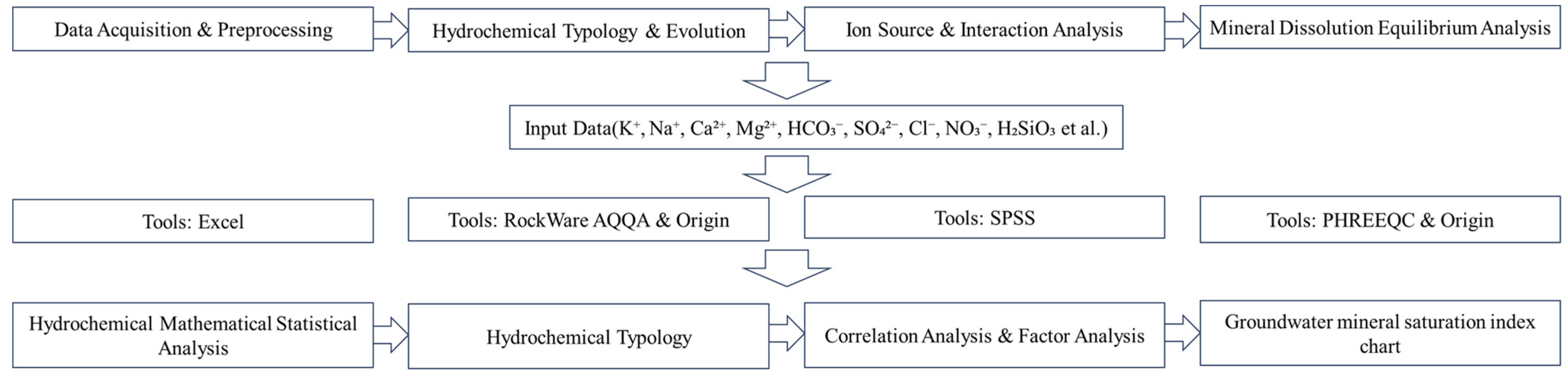
2.3. Methodology
3. Results and Discussion
3.1. Statistical Characteristics of Groundwater Components
3.2. Characteristics of Hydrochemical Types
3.3. Analysis of Hydrochemical Genesis
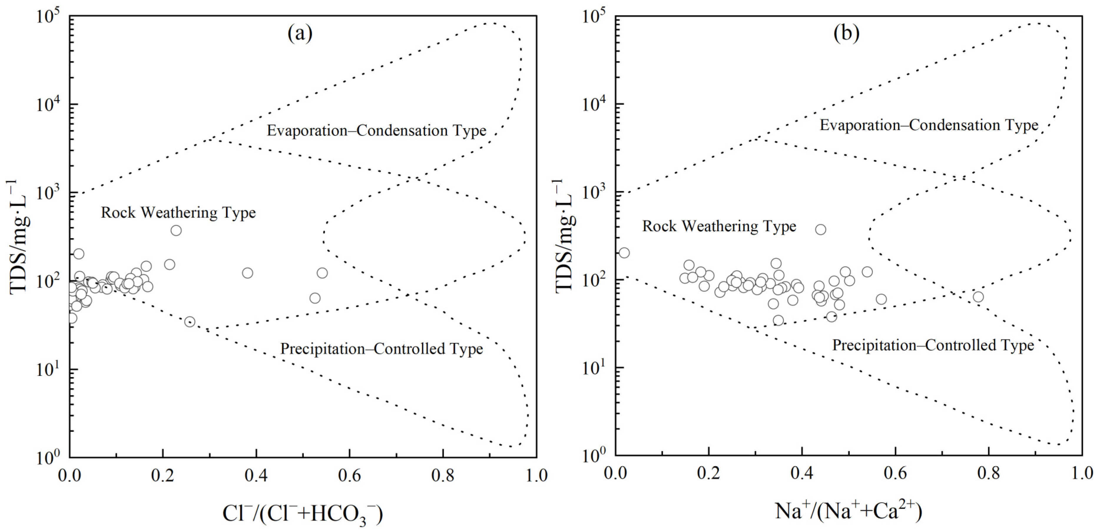
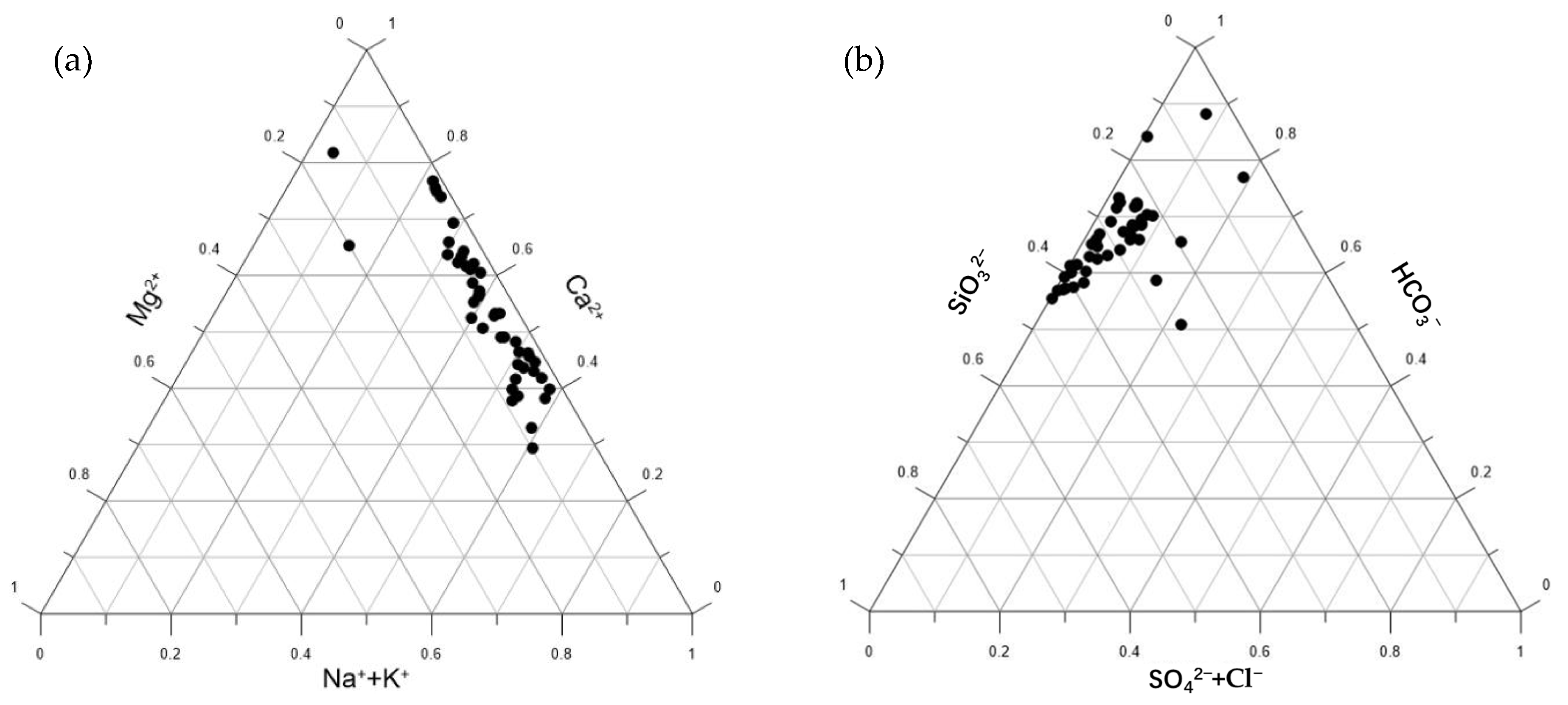
3.3.1. Control Analysis of Ion Composition
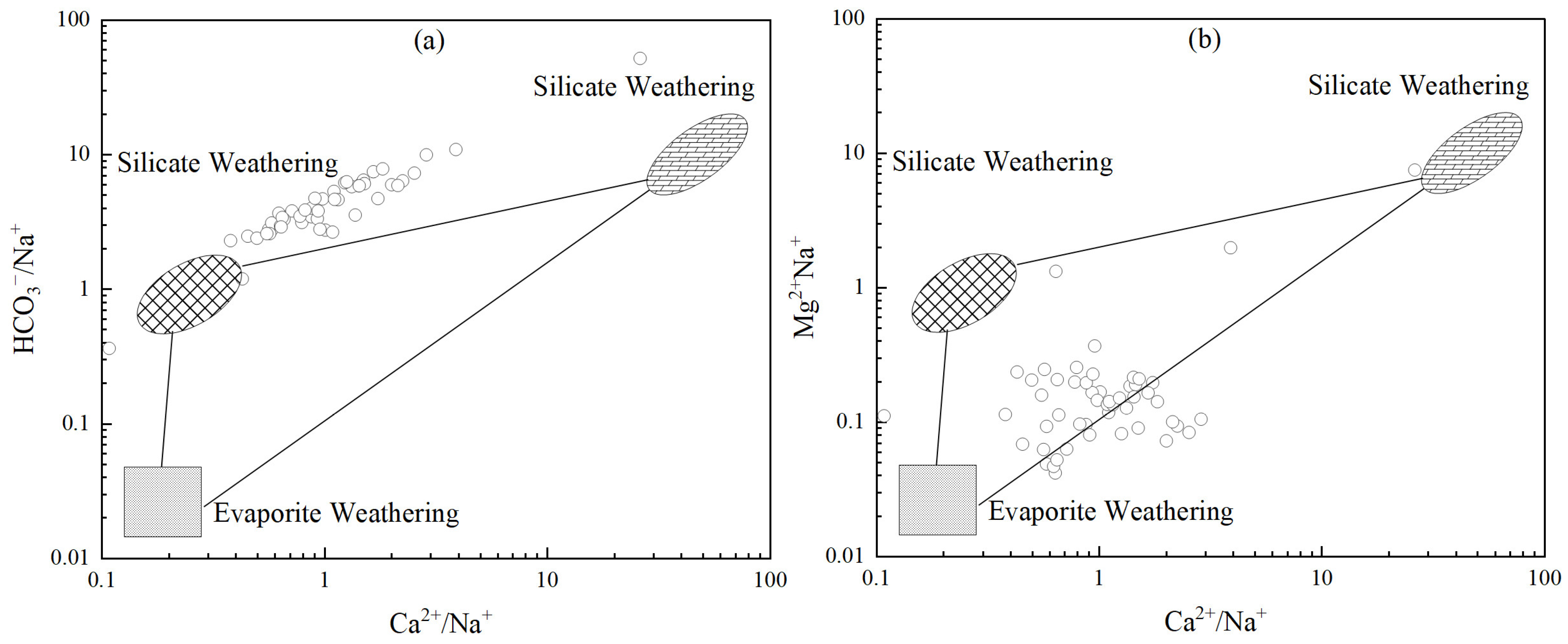
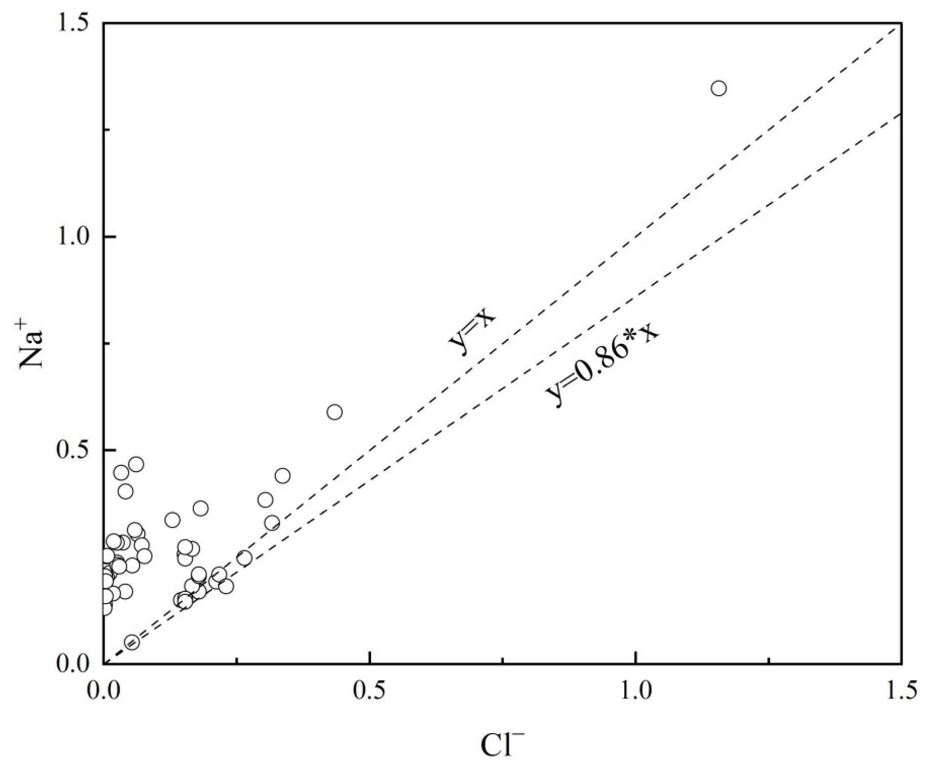
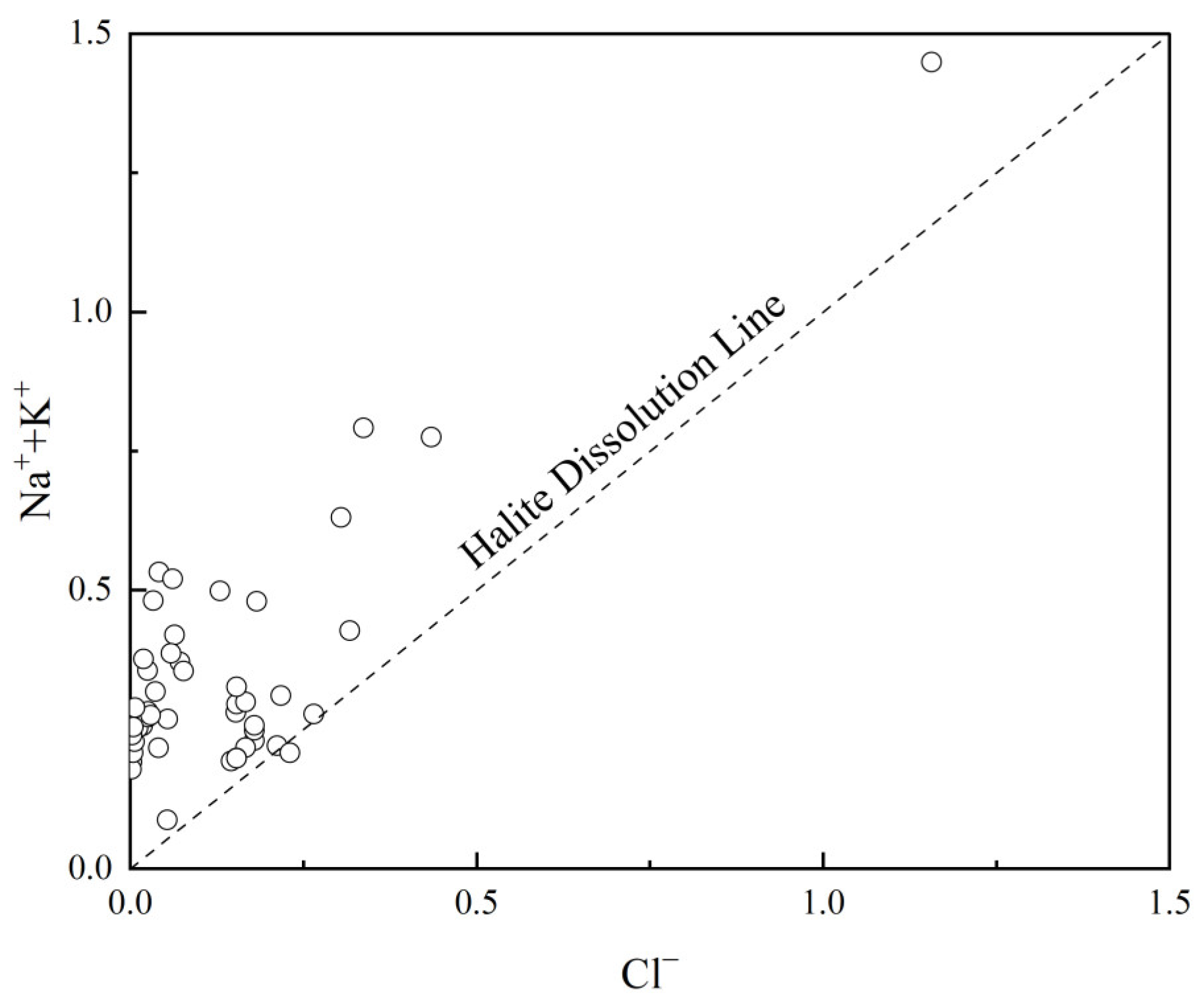
3.3.2. Analysis of Ion Proportionality Coefficients
- γNa/γCl
- 2.
- SO42−/Ca2+ and NO3−/Ca2+
- 3.
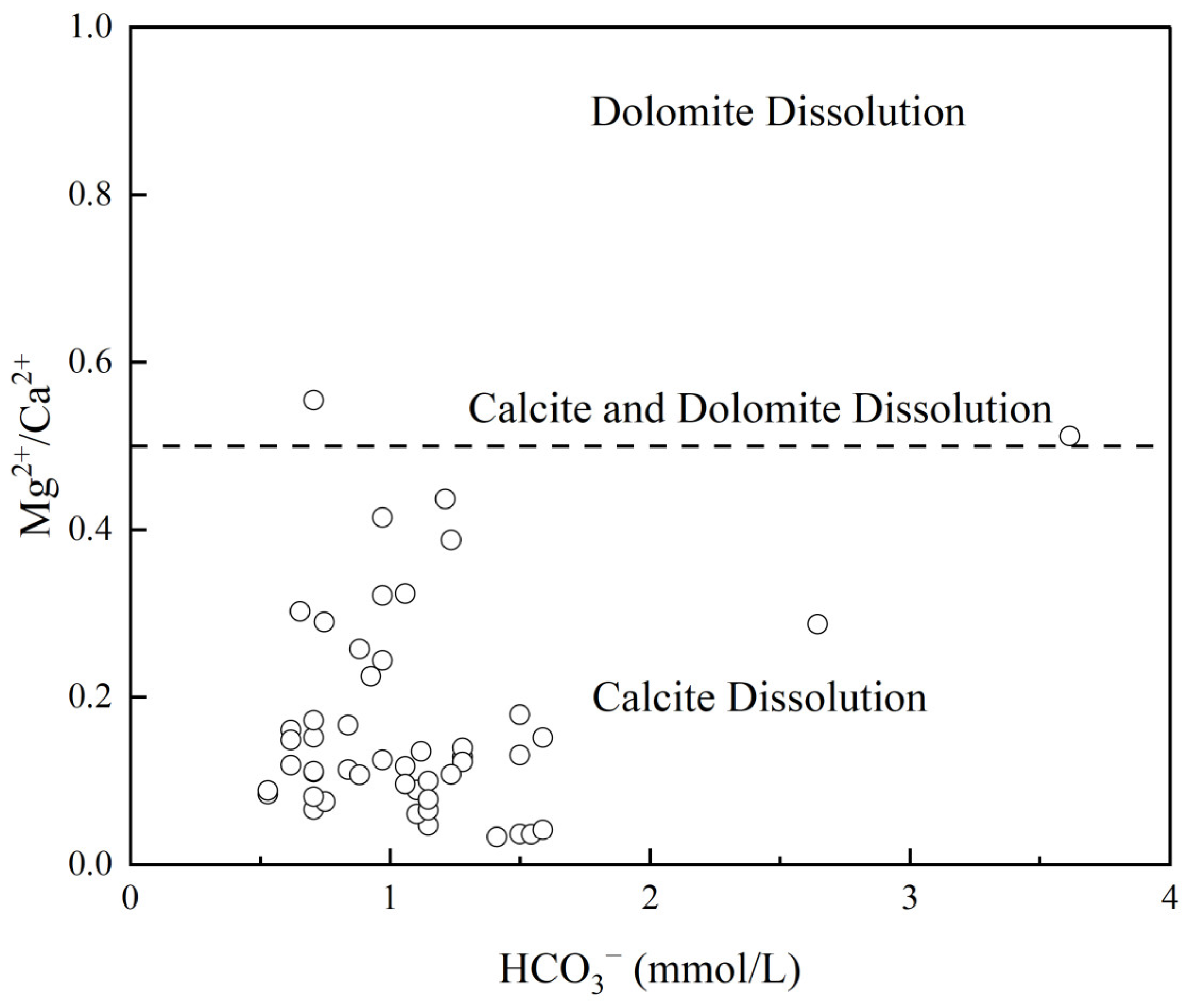
- Ca2+/Mg2+
- 4.
- Mg2+/Ca2+ and HCO3−
- 5.
- (Mg2++Ca2+) and (HCO3−+SO42−)
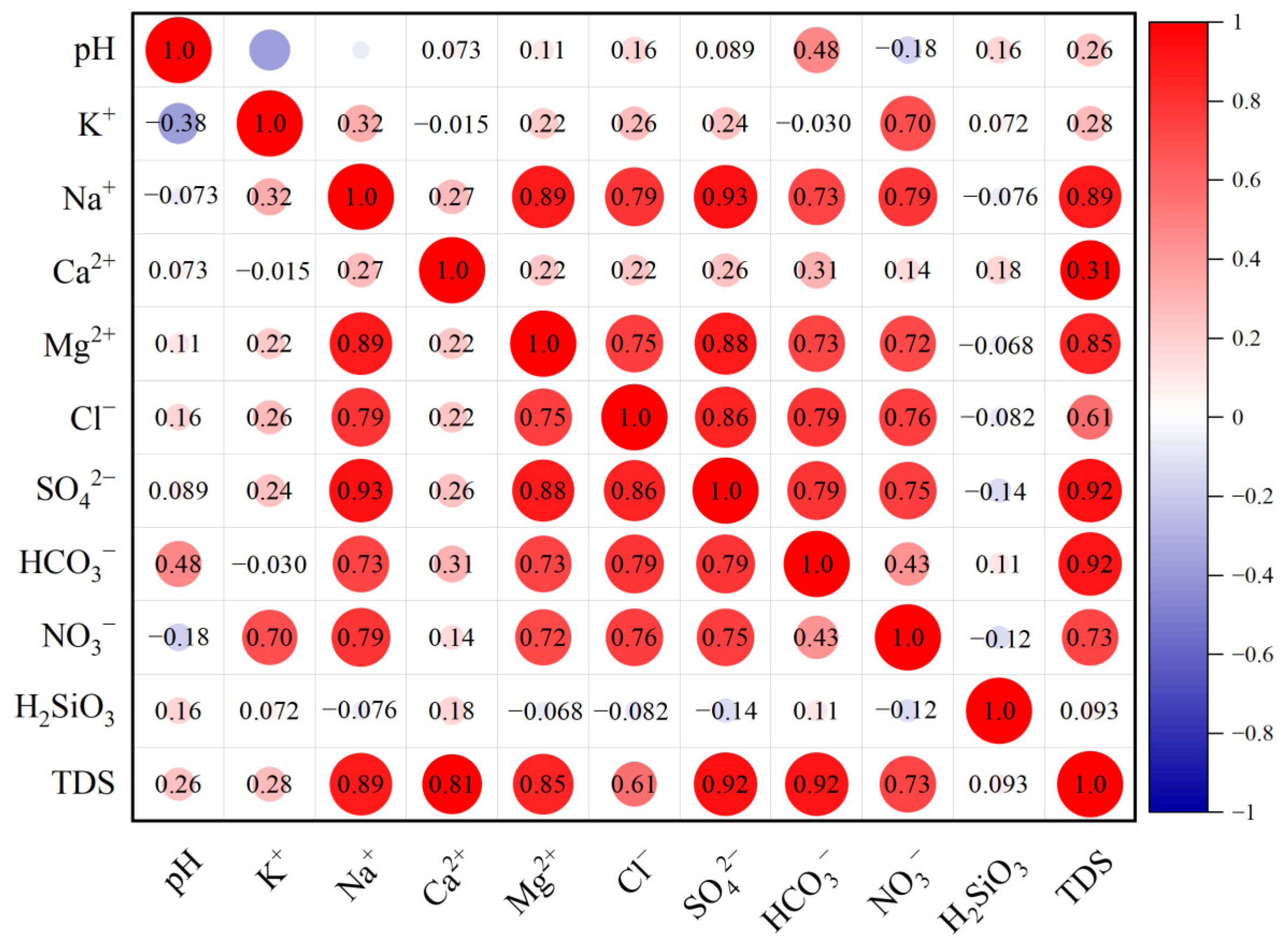
3.3.3. Correlation Analysis of Ion Sources
- 6.
- Correlation Analysis
- 7.
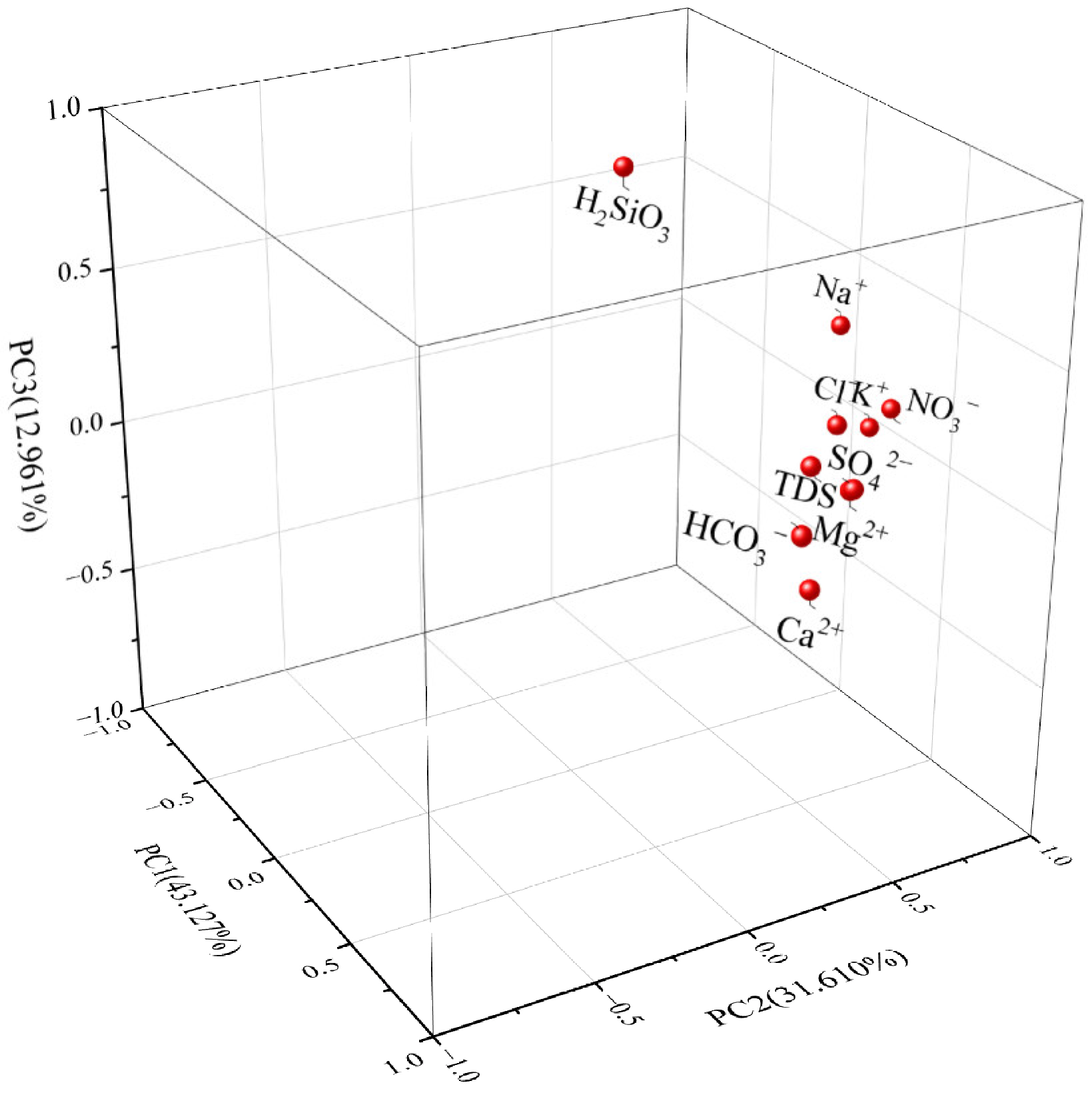
- Factor Analysis
3.3.4. Mineral Dissolution Equilibrium
4. Conclusions
Author Contributions
Funding
Data Availability Statement
Conflicts of Interest
References
- Ren, C.; Zhang, Q. Groundwater Chemical Characteristics and Controlling Factors in a Region of Northern China with Intensive Human Activity. Int. J. Environ. Res. Public Health 2020, 17, 9126. [Google Scholar] [CrossRef] [PubMed]
- Hua, K.; Xiao, J.; Li, S.; Li, Z. Analysis of Hydrochemical Characteristics and Their Controlling Factors in the Fen River of China. Sustain. Cities Soc. 2020, 52, 101827. [Google Scholar]
- Khan, A.; Khan, H.H.; Umar, R. Impact of land-use on groundwater quality: GIS-based study from an alluvial aquifer in the western Ganges basin. Appl. Water Sci. 2017, 7, 4593–4603. [Google Scholar]
- Zhao, X.; Xiao, P.; Li, Y.; Shao, C. Hydrochemical Characteristics and Genesis of Shallow Groundwater in Water Shortage Area of Southern Jiangxi Province—Taking Yinkeng Sheet as an Example. South China Geol. 2021, 37, 418–426. [Google Scholar]
- Zhao, X.; Xiao, P.; Song, W.; Li, Y.; Liu, Q. Hydrochemical Characteristics and Genetic Analysis of Groundwaterin Red-Bed Area of South Jiangxi Province. Sci. Technol. Eng. 2023, 23, 14112–14122. [Google Scholar]
- Khan, A.; Umar, R.; Khan, H.H. Hydrochemical characterization of groundwater in lower Kali watershed, Western Uttar Pradesh. J. Geol. Soc. India 2015, 86, 195–210. [Google Scholar]
- Liu, J.; Wang, X.; Xu, W.; Song, M.; Gong, L.; Zhang, M.; Li, L.; He, L. Hydrogeochemistry of Fluorine in Groundwater in Humid Mountainous Areas: A Case Study at Xingguo County, Southern China. J. Chem. 2021, 2021, 1–11. [Google Scholar]
- Sun, Z.; Gao, Z.; Wang, X.; Lin, H.; Song, M. Exploration of Mineral Water Outcropping Pattern in the Mountainous Area of South Jiangxi. Acta Geosci. Sin. 2018, 39, 565–572. [Google Scholar]
- Chen, W.; Wu, Y.; Zhang, H.; Liu, H. Hydrochemical Characteristics and Formation Mechanism Of groundwater in the Western Part of Hepu Basin. Environ. Sci. 2024, 45, 194–206. [Google Scholar]
- Piper, A.M. A Graphic Procedure in the Geochemical Interpretation of Water-analyses. Neurochem. Int. 1984, 6, 27–39. [Google Scholar]
- Gibbs, R.J. Mechanisms Controlling World Water Chemistry. Science 1970, 170, 1088–1090. [Google Scholar] [PubMed]
- Wei, S.; Ding, G.; Yuan, G.; Wang, L.; Nie, Y.D. Hydrochemical Characteristics and Formation Mechanismof Groundwater in Yinan Area of Dongwen River, Shandong Province. Acta Geol. Sin. 2021, 95, 1973–1983. [Google Scholar]
- Meng, L. Recharge Source and Evolution Process of Karst Groundwater in Tai’an Urban Area Based on Hydrochemistry and Hydrogen and Oxygen Lsotopes. Environ. Sci. 2024, 45, 2096–2106. [Google Scholar]
- Sun, Y.; Ji, H.; Luo, J.; Jiang, Y.; Li, T. Hydro-Geochemistry and Chemical Weathering Processes of Small Water Sheds in the Southern Jiangxi Province. Environ. Chem. 2006, 25, 550–557. [Google Scholar]
- Sun, Z. Chemical Characteristics and Genesis of Mineral Water in Southern Jiangxi Mountainous Areas. Master’s Thesis, Shandong University of Science and Technology, Qingdao, China, 2019. [Google Scholar]
- Zhang, S.; Xiao, F.; Zou, Y. Discovery of Geothermal Associated Helium Resources and Exploration of Their Anomalous Origins in the Southern Jiangxi Region. Nat. Gas Geosci. 2023, 35, 495–506. [Google Scholar]
- Liu, X.; Luo, H.M.; Jia, F. Geological Characteristics of Rock Mass and Uranium Ore Exploration Sign in Taoshan Area. Zhejiang Geological Society. In Proceedings of the 2015 Academic Annual Meeting of Zhejiang Geological Society, Lishui, China, 13 November 2015; Zhejiang Nuclear Industry 262nd Brigade; In Memory of the 120th Anniversary of the Birth of Geologist Zhu Tinghu. Zhejiang Huzhou Geological Technology Development Company: Huzhou, China, 2015; p. 6. [Google Scholar]
- Xu, X.S.; Zhang, H.; Wu, Y.; Dong, X.Y. The Disintegration of the Taoshan Composite Granite Body in Southern Jiangxi and Its Geological Significance. China Nuclear Society. In Progress Report on Nuclear Science and Technology in China (Volume 6), Proceedings of the 2019 Academic Annual Meeting of China Nuclear Society Volume 1 (Uranium Geology Section (Part 1)). Nuclear Industry 270th Institute, Beijing, China, 20–23 August 2019; China Atomic Energy Press: Beijing, China, 2019; p. 10. [Google Scholar]
- GB/T 13727-2016; Code of Geologic Exploration of Natural Mineral Water Resources. General Administration of Quality Supervision: Beijing, China; Inspection and Quarantine of China: Beijing, China; China Standards Press: Beijing, China, 2016.
- Zhao, K.; Jiang, S.; Dong, C.; Chen, W.; Chen, P.; Ling, H.; Zhang, J.; Wang, K. Uranium-Bearing and Barren Granites from the Taoshan Complex, Jiangxi Province, South China: Geochemical and Petrogenetic Discrimination and Exploration Significance. J. Geochem. Explor. 2011, 110, 126–135. [Google Scholar]
- Sun, T.; Liao, Z.; Wu, K.; Chen, L.; Liu, W.; Yi, C. Fractal Distribution Characteristics and Geological Significances of Fracturestructure in Southern Jiangxi. J. Jiangxi Univ. Sci. Technol. 2017, 38, 48–54. [Google Scholar]
- GB 8537-2018; National Food Safety Standard—Drinking Natural Mineral Water. National Health Commission of the People’s Republic of China: Beijing, China; State Administration for Market Regulation: Beijing, China; China Standards Press: Beijing, China, 2019.
- Zhao, H. Groundwater Recharge, Discharge, Runoff Characteristics and Hydrochemical Evolution of Hamatong River Basin in Sanjiang Plain. Master’s Thesis, Jilin University, Changchun, China, 2017. [Google Scholar]
- Xiao, J.; Jin, Z.D.; Zhang, F.; Wang, J. Solute Geochemistry and Its Sources of the Groundwaters in the Qinghai Lake Catchment, NW China. J. Asian Earth Sci. 2012, 52, 21–30. [Google Scholar]
- Liu, H.; Song, Y.; Li, Y.; Wei, W.; Zhao, G.; Wang, X.; Huang, J. Hydrochemical Characteristics and Control Factors of Shallow Groundwaterin Anging Section of the Yangtze River Basin. Environ. Sci. 2024, 45, 1525–1538. [Google Scholar]
- Edmond, J.M.; Palmer, M.R.; Measures, C.I.; Brown, E.T.; Huh, Y. Fluvial Geochemistry of the Eastern Slope of the Northeastern Andes and Its Foredeep in the Drainage of the Orinoco in Colombia and Venezuela. Geochim. Et Cosmochim. Acta 1996, 60, 2949–2974. [Google Scholar]
- Zhu, B.; Yu, J.; Qin, X.; Rioual, P.; Zhang, Y.; Liu, Z.; Mu, Y.; Li, H.; Ren, X.; Xiong, H. Identification of Rock Weathering and Environmental Control in Arid Catchments (Northern Xinjiang) of Central Asia. J. Asian Earth Sci. 2013, 66, 277–294. [Google Scholar]
- Zhang, T.; He, J.; Li, J.; Cao, Y.; Gong, L. Major Ionic Features and Possible Controls in the Groundwater in the Hamatong River Basin. Environ. Sci. 2018, 39, 4981–4990. [Google Scholar]
- He, J.; Ma, J.; Zhang, P.; Tian, L.; Zhu, G.; Edmunds, W.; Zhang, Q. Groundwater Recharge Environments and Hydrogeochemical Evolution in the Jiuquan Basin, Northwest China. Appl. Geochem. 2012, 27, 866–878. [Google Scholar]
- Qu, S.; Liang, X.; Liao, F.; Mao, H.; Xiao, B.; Duan, L.; Shi, Z.; Wang, G.; Yu, R. Geochemical Fingerprint and Spatial Pattern of Mine Water Quality in the Shaanxi-Inner Mongolia Coal Mine Base, Northwest China. Sci. Total Environ. 2023, 854, 158812. [Google Scholar]


| Parameters | K+ | Na+ | Ca2+ | Mg2+ | Cl− | SO42− | HCO3− | NO3− | TDS | H2SiO3 | pH |
|---|---|---|---|---|---|---|---|---|---|---|---|
| Maximum | 13.73 | 13.56 | 53.20 | 15.77 | 15.41 | 37.63 | 220.41 | 25.61 | 228.16 | 48.56 | 7.82 |
| Minimum | 0.92 | 1.17 | 3.94 | 0.20 | 0.03 | 0.07 | 32.26 | 0.03 | 37.93 | 8.88 | 6.55 |
| Mean | 2.53 | 5.52 | 12.28 | 1.40 | 3.72 | 2.26 | 67.74 | 2.82 | 90.70 | 34.15 | 7.13 |
| Standard Deviation | 2.22 | 2.18 | 9.78 | 2.60 | 3.71 | 5.61 | 32.76 | 5.26 | 34.86 | 8.04 | 0.29 |
| Coefficient of Variation | 0.88 | 0.39 | 0.80 | 1.85 | 1.00 | 2.49 | 0.48 | 1.87 | 0.38 | 0.24 | 0.04 |
Disclaimer/Publisher’s Note: The statements, opinions and data contained in all publications are solely those of the individual author(s) and contributor(s) and not of MDPI and/or the editor(s). MDPI and/or the editor(s) disclaim responsibility for any injury to people or property resulting from any ideas, methods, instructions or products referred to in the content. |
© 2025 by the authors. Licensee MDPI, Basel, Switzerland. This article is an open access article distributed under the terms and conditions of the Creative Commons Attribution (CC BY) license (https://creativecommons.org/licenses/by/4.0/).
Share and Cite
Wang, X.; Wang, Y.; Gao, G.; Li, M.; An, H.; Mao, K.; Wang, Y.; You, J.; Sun, Z.; Gong, L.; et al. Hydrochemical Characteristics and Genesis of Groundwater in Taoshan Granite Body, Yushan Uplift Area, South Jiangxi, China. Water 2025, 17, 974. https://doi.org/10.3390/w17070974
Wang X, Wang Y, Gao G, Li M, An H, Mao K, Wang Y, You J, Sun Z, Gong L, et al. Hydrochemical Characteristics and Genesis of Groundwater in Taoshan Granite Body, Yushan Uplift Area, South Jiangxi, China. Water. 2025; 17(7):974. https://doi.org/10.3390/w17070974
Chicago/Turabian StyleWang, Xinfeng, Yan Wang, Ge Gao, Mingming Li, Hongyan An, Kuanzhen Mao, Yibing Wang, Jiangong You, Zhijie Sun, Lei Gong, and et al. 2025. "Hydrochemical Characteristics and Genesis of Groundwater in Taoshan Granite Body, Yushan Uplift Area, South Jiangxi, China" Water 17, no. 7: 974. https://doi.org/10.3390/w17070974
APA StyleWang, X., Wang, Y., Gao, G., Li, M., An, H., Mao, K., Wang, Y., You, J., Sun, Z., Gong, L., Song, M., & Liu, Y. (2025). Hydrochemical Characteristics and Genesis of Groundwater in Taoshan Granite Body, Yushan Uplift Area, South Jiangxi, China. Water, 17(7), 974. https://doi.org/10.3390/w17070974