Article

Research on the Audit Rules for National Mountain Flood Disaster Survey and Evaluation Results of Key Towns and Villages

1
China Institute of Water Resources and Hydropower Research, Beijing 100038, China
2
National Institute of Natural Hazards, Ministry of Emergency Management of China, Beijing 100085, China
*
Author to whom correspondence should be addressed.
Water 2025, 17(6), 773; https://doi.org/10.3390/w17060773
Submission received: 2 December 2024 / Revised: 6 February 2025 / Accepted: 13 February 2025 / Published: 7 March 2025
(This article belongs to the Special Issue Recent Advances in Flood Risk Assessment and Management)

Abstract

:
In recent years, there have been frequent extreme weather events that defy traditional understanding. Specifically, mountain flood disasters can cause significant loss of life due to their sudden onset and destructive power. The 7.21 flood event in Xingyang, Zhengzhou, China, recorded a maximum 6 h precipitation of 240.5 mm in the Suo River basin, corresponding to a 500-year return period, and causing fatalities and substantial damage. The central government of China has launched supplementary mountain flood disaster surveys and evaluations involving key towns and villages, following an initial round of surveys in riverside villages, to improve foresight and response capabilities for mountain flood disaster risks under extreme conditions. This paper introduces the contents of the national mountain flood disaster surveys and evaluations of key towns and villages, elaborating on the principles, content, and rules for auditing the national survey and evaluation results. This paper innovatively proposes professional audit criteria, such as early warning indicators, monitoring facility correlations, and hazard zoning, based on a formal audit of the data quality. The implementation of professional audit criteria improved the data accuracy by 85% and reduced false alarms by 40%, enhancing the overall effectiveness of mountain flood disaster prevention. The analysis of the audit results suggests that the audit rules for the survey and evaluation results of key towns are scientific, reasonable, and effective, achieving the expected goals of data quality control. This approach can effectively enhance the practical value of the survey and evaluation outcomes for key towns, laying a solid data foundation for transforming flood disaster prevention from merely “existing” to “optimal”.

1. Introduction

China is one of the most flood-prone countries in the world, with mountainous and hilly areas covering about 70% of the national land area. There are widespread and frequent mountain flood disasters in China, which pose a serious threat to the public safety of the people in mountainous areas. The average annual death toll from mountain floods accounted for more than 70% of the deaths caused by flood disasters between 2000 and 2010, making it a critical weak link in flood control and disaster reduction. General Secretary Jinping Xi has made several important remarks, emphasizing the need to strengthen risk assessment and early warning systems, focus on weak links, and comprehensively prevent and mitigate disaster risks [1]. Over CNY 40 billion were invested nationwide between 2010 and 2023, and a preliminary national mountain flood disaster defense system was established, achieving significant disaster prevention and reduction benefits. In particular, the annual death toll from mountain floods decreased by 70%.
The Ministry of Water Resources and the Ministry of Finance jointly launched a national mountain flood disaster prevention project in 2013 in order to further improve the mountain flood disaster defense efforts [2]. This project proposed a construction plan for flood disaster surveys and the supplementation and improvement of non-engineering measures and flood control of key mountain flood channels, and a national survey and evaluation of mountain flood disasters was initiated in 2013. Surveys and evaluations of mountain flood disasters are the foundation for prevention projects and can provide strong support for the supplementation and improvement of non-engineering measures and flood control of key mountain flood channels. The suddenness, extremity, and abnormality of mountain floods have become more pronounced as global climate change continues. Meanwhile, populations and wealth are growing as economic and social development continues, and the influence of mountain flood disasters on the economy, society, and people’s lives are becoming increasingly widespread and severe. Great efforts have been made to enhance the ability to foresee and respond to risks from extreme mountain flood events to proactively adapt to the “normality” of frequent extreme flood and drought disasters [3]. For example, a supplementary survey and evaluation project of mountain flood disasters was launched nationwide in 2021, and 13,337 additional key towns were included in the survey and evaluation lists based on the first round of surveys and evaluations conducted in riverside villages between 2013 and 2015. This project comprehensively identified and established a list of targets for mountain flood disaster defense, and surveys and evaluations of key towns were completed between 2021 and 2023 under the organization and promotion of the national mountain flood disaster prevention project team.
The survey and evaluation work for key towns and villages mainly consists of three aspects. First, a detailed survey is conducted on the socio-economic conditions, hazard zones, monitoring and early warning facilities, small watersheds, water-related projects, residents’ living details (e.g., latitude and longitude of each household building, elevation of the foundation, address, population, and housing types), and historical flood data [4]. Surveys are also conducted on river control sections and topographic maps of important towns, forming the basis of the survey report [5]. Second, an evaluation is carried out regarding the design rainfall, design flood, critical rainfall, determination of early warning indicators, and hazard zone mapping based on the survey results. A comprehensive evaluation of the current flood control capacity of key towns and villages is thereafter implemented, and the flooding scope for events such as 5-year, 10-year, 20-year, 50-year, and 100-year floods are calculated. The hazard levels for different areas are determined, and an evaluation report is then formed. Third, the inspection and acceptance of the survey and evaluation project are organized, followed by the creation of an acceptance report. The main contents of the key town and village survey and evaluation protocol are shown in Figure 1.
Different regions have adopted various approaches to flood disaster investigation and assessment: Beizhen City has implemented systematic data collection and analysis; Guangdong Province utilizes software-based automatic verification combined with manual rationality checks; Liaoning Province ensures data quality through position, process, and link controls; Yunnan Province relies on pilot projects, professional training, and technical controls [6]. However, these studies generally lack specialized verification guidelines, resulting in data quality that fails to meet high standards, particularly in terms of accuracy, completeness, consistency, and timeliness. These issues urgently need to be addressed to improve the scientific and reliable foundation for flood disaster prevention [7]. These high standards are crucial for ensuring the reliability of mountain flood risk evaluation, which in turn affects the effectiveness of disaster prevention and reduction measures. In response, this paper innovatively proposes some professional audit guidelines on early warning indicators, monitoring facility associations and hazard zone classification [8]. The rationality of these guidelines were validated through application in demonstration areas, providing strong foundational support for improving data quality and enhancing the effectiveness of mountain flood disaster surveys and evaluations.

2. Methodology and Databases

2.1. Databases

Supplemental surveys and evaluations of mountain flood disasters cover a vast area, involving extensive data entry, editing, verification, and compilation. The workload is immense, encompassing multi-level data integration, quality checks, and summarization across various provinces nationwide [9]. The process spans a long time frame and is complex in nature. The data to be verified include multiple types, including tabular data, spatial data, photos, and documents, each with their own characteristics. The data contents are intricate, involving nationwide multi-level data integration and quality inspection, with numerous interrelations and dependencies, making their verification challenging [10]. Additionally, frequent data updates and version changes add to the complexity of repeated verification and comparison. Throughout the review process, ensuring data timeliness, accuracy, and consistency, while managing complex oversight requirements and real-time process control, is critical to maintain high-quality data standards.

2.2. Automated Software Verification

An automated verification system was developed to conduct initial checks, including layer integrity, conformity of attribute data structures, range validation, logical consistency of attributes, extension and spatial relationship analysis of graphical data, and checks for fragmented lines and areas [11]. These automated processes enhance data processing efficiency and ensure that the data comply with fundamental standards and requirements at the preliminary stage.

2.3. Manual Verification

Manual verification is conducted in three main aspects: (1) attribute verification, which involves experience-based judgment, data comparison, and outlier analysis; (2) graphical verification, which focuses on the accuracy, rationality, and consistency of mapping; (3) photograph verification, which checks for location accuracy and compliance with the standards [12]. These manual checks ensure the precision and consistency of the data, complementing the shortcomings of automated verification.

2.4. Hazard Zone–Station Correlation

One of the key innovations in this study is the monitoring facility correlation analysis, using the hazard zone–station correlation method. This involves associating hazard zone data with spatial locations or other relevant information from monitoring stations to determine the correlation between two layers.
In spatial analysis, tools like Geographic Information Systems (GIS) are used to perform this correlation. Initially, hazard zone and station data are imported into the GIS, ensuring they share the same coordinate system and projection for accurate spatial matching [13]. GIS spatial querying and analysis functions are then employed to link elements from both layers based on spatial location, distance, direction, etc. For example, stations located within hazard zones can be identified, or the nearest station-to-hazard zone distance can be calculated.
Beyond spatial location, other related information, such as attribute data, can also be used to enhance the correlation, offering a more comprehensive understanding of the relationship between the two layers, using factors like address or administrative codes.

2.5. Topological Checking

Topology, originally known as positional analysis, is a branch of geometry that studies the invariant properties of shapes (or sets) under continuous deformation. It focuses on the spatial relationships between objects, disregarding their shape and size. Topological checking involves verifying whether there are topological errors within the same layer, such as point-line-plane errors, or spatial topological errors between multiple layers [14]. Using the feature datasets in ArcGIS 10.8 software, typical checks for a given feature class include verifying that features “cannot overlap”, “cannot have gaps”, and “cannot intersect”.

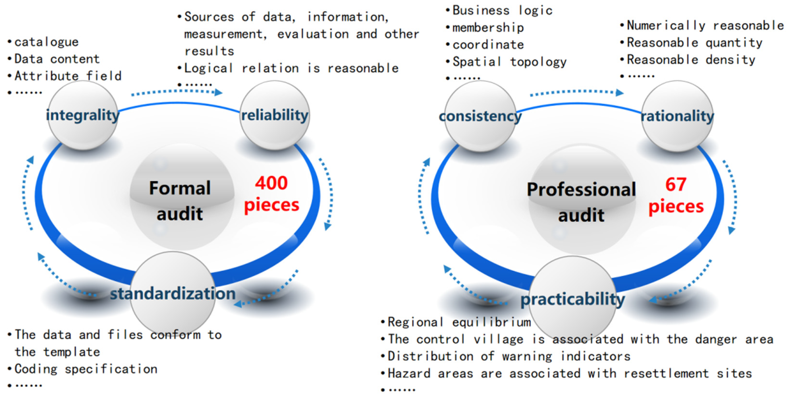
3. Audit Principles, Contents, and Rules

3.1. Audit Principles

The National Mountain Flood Disaster Prevention Project Team is responsible for central-level audits. The audits assess the data quality from various aspects, such as the overall volume and completeness of the data, the balance of data distribution, and the rationality of the results. Audit reports include summary statistical tables and distribution maps of the reported data (e.g., maps showing the distribution of key towns, hazard zones, monitoring and early warning facilities, water-related projects, historical mountain flood disasters, business locations, flood control capacities, and early warning indicators). Any issues discovered during the audit are promptly communicated to each province, and the data reported by the provinces are promptly stored and mapped to reflect the results of the survey and evaluation. The main processes are as follows:
(1)
Data reception at the provincial level;
(2)
Formal audit;
(3)
Data entry and mapping;
(4)
Professional audit;
(5)
Compilation into the national-level results database;
(6)
Project acceptance.

3.2. Audit Contents

The audit contents include six aspects, i.e., reliability, completeness, standardization, consistency, rationality, and practicality of the data, in order to ensure that the national survey and evaluation cover all important towns and villages in the mountainous areas and avoid inconsistencies in the standards or insufficient risk identification, which could lead to gaps in mountain flood disaster defense work [5]. Figure 2 shows the audit contents of the survey and evaluation results of key towns and villages. The audit pass rate should be above 95%. First, the sources of the data and documents are evaluated to ensure their credibility. Next, the completeness of the data catalog and contents is audited to ensure all necessary data files and information are included. Thereafter, the data and document formats are checked for compliance with the technical requirements. Additionally, the logical and spatial consistency of the data is checked, verifying the affiliations and consistency in the latitude and longitude and conducting topological checks on vector data to avoid potential errors. The rationality of the data is evaluated on the basis of reports from the provinces, with methods such as density statistics and spatial distribution comparisons, assessing the reasonableness of the value ranges and the survey object numbers and densities. Lastly, the practicality of the data is audited to ensure that they can effectively support the mountain flood prevention plan and enhance the capacity to deal with extreme climate changes. This systematic audit process can not only improve the reliability and effectiveness of the data but also lays a solid foundation for subsequent disaster prevention and reduction measures, aiding the government and relevant departments in better prediction and response to mountain flood disasters and thus ensuring the safety of the lives and property of the residents.

3.3. Audit Rules

The surveys and evaluations are conducted with small watersheds as the basic unit. The surveys should accurately reflect the natural conditions, socio-economic status, water conservancy projects, and hydro-meteorological conditions of residential areas [15]. The analyses and evaluations may include rainfall early warnings, water level warnings, and dynamic warnings based on distributed hydrological models according to the watershed area size. The audit rules for surveys include over 400 formal audit items and 67 professional audit items in view of the specific conditions in the country.

3.3.1. Formal Audits

Formal audits focuse on the data reliability, completeness, and standardization, identifying common issues such as missing task quantities, missing catalogs, content that does not match the template, duplicate primary keys, column type mismatches, column relationship restrictions, input condition violations, column value range violations, encoding inconsistencies, and missing layers. The key audit contents are as follows:
(i)
Attribute Tables
There are 41 attribute tables for the key towns and villages, 16 out of which are particularly important (see Table 1). These important attribute tables must be submitted with the corresponding spatial layers and complete attributes. The audit is conducted based on the main lines of the analysis and evaluation catalogs in Table 1 and the administrative division catalog in Table 2. The point layers representing the locations of key towns and villages should correspond to the community centers or downtown areas rather than center points converted from polygons.
(ii)
Spatial data
There are 22 categories of spatial data corresponding to the relevant attribute tables (details in Table 2). It is important to note that after the first round of surveys and evaluations conducted between 2013 and 2015, the spatial data of new hazard zones should also be provided, including hazard zone codes and the codes of the villages they belong to. The specific audit content rules are as follows:
(1)
Spatial data should correspond with the attribute tables (with unique matching values).
(2)
Spatial layers should not exceed the survey scope of the key towns and villages.
(3)
Spatial data should not have topological errors (overlaps, self-intersections, and gaps).
(4)
All latitude and longitude coordinates must be accurate to at least six decimal places.
(iii)
Multimedia
Multimedia materials include photos and their index files, corresponding to nine categories: residential households in towns and villages, enterprises and institutions, housing classification, historical flood marks, road culverts, bridge projects, dam projects, cross-sections, and longitudinal sections. The specific audit content rules are as follows:
(1)
Multimedia photos should not be duplicated.
(2)
Multimedia photos should not be misplaced.
(3)
Photo-naming conventions should be followed, and index tables should be complete.
(4)
The multimedia attribute Table 2 should be consistent with the photo index table.

3.3.2. Professional Audits

Professional audits are based on the characteristics of mountain flood disaster prevention, focusing on the consistency, rationality, and practicality of the data. First, the representativeness of the towns and villages is audited to avoid concentration in certain watersheds. Then, key aspects are audited, e.g., socio-economic data, early warning indicators, hazard zone classification, and monitoring facilities. Finally, audit summary statistical tables and distribution maps are produced to analyze the balance of data distribution on a macro level and ensure the usability of additional survey and evaluation data.
(i)
Data Consistency Audits
Data consistency audits focus on the business logic consistency, affiliation consistency, latitude and longitude consistency, and spatial topology.
  • Business logic consistency audits examine whether the relationships among various data elements conform to the technical requirements.
  • Affiliation consistency audits ensure that the spatial location of the data corresponds correctly to the administrative divisions. Regarding the point features, this step checks if they fall within the corresponding administrative area; regarding line features, this step checks if they intersect or are contained within the administrative boundaries.
  • Latitude and longitude consistency audits ensure that the coordinate systems of the data are consistent.
  • Spatial topology audits are performed on vector data, especially for line and polygon data. Topological errors, such as overlapping hazard zones or flood control routes, are not allowed.
(ii)
Data Rationality Audits
The rationality of the reported data is audited using methods such as density statistics and spatial distribution comparisons.
(1)
Numerical value rationality audits
Numerical value rationality audits check the reasonableness of the numerical range and numerical type, focusing on the numerical value in the table and spatial attribute table. These values should not exceed the specified numerical range or contain content outside of the specified numerical type, and the data of various results should be in line with the reliable conditions.
(2)
Quantity rationality audits
Quantity rationality audits compare the survey data of key cities, towns, and enterprises with the number of tasks issued by the provinces to determine the rationality of the number of survey objects. The numbers of key towns and evaluation targets are counted, and their proportions to the total number of administrative districts are evaluated to assess the quality and rationality of the survey and evaluation work.
(iii)
Practicality Audits
The main goal of all audits is practicality, i.e., using these data to issue early warnings and guide evacuation. The following newly added audit items are also aimed at ensuring the practicality of the audits, and more attention should be given to them:
(1)
Regional distribution balance;
(2)
Correlation between prevention and control villages and hazardous hazard zones;
(3)
Distribution of early warning indicators;
(4)
Correlation between hazard zones and evacuation sites.
For example, population data are key socio-economic attribute data for mountain flood disaster prevention, serving as a basis for building community-based flood monitoring and defense systems. Population data audits are implemented as follows:
(1)
The population data are compared with the 2021 National Statistical Yearbook to identify outliers.
(2)
The reasonableness of the population-to-household ratios are checked, e.g., typical family households have fewer than 10 people, while hospitals and schools may have more than 100 people. In special cases, there may be no residents in livestock farming hazardous areas.
(3)
The population density balance is audited, comparing the town-level, county-level, and provincial-level population densities.
(4)
The logical consistency of the population distribution is verified, e.g., the population in hazard zones should be less than the total population, and the number of households in hazard zones should be lower than total number of households.

4. Newly Added Professional Audit Guidelines

4.1. Early Warning Indicator Analysis

The warning indicators commonly used in various provinces are critical flow back-calculated from disaster-causing water levels and warning indicators back-calculated from designed storm flood events. The warning levels include preparation for evacuation and immediate evacuation, with warning periods ranging from 1 to 3 to 6 h. The following methods are used to detect significant deviations in early warning indicators:
(1)
Logical consistency: Regarding the same warning level, 1-h < 3-h, 3-h < 6-h, and villages < towns. In the same region, the warning level should be logically reasonable under very dry, moderate, and very moist soil conditions.
(2)
Comparison of early warning indicators with the design cloudburst: The early warning indicators for 1, 3, and 6 h are compared for different recurrence intervals (5, 10, 20, 50, and 100 years). More attention should be paid to the early warning indicators for return periods less than 5 years and more than 50 years.
(3)
Comparison with the flood control capacity: Early warning indicators should not exceed the flood control capacity; otherwise, the early warning indicator setting may be unreasonable.
(4)
Comparison of similar small watershed management units: The results of early warning indicators are compared and analyzed in the small watersheds that share similar characteristics, including geometric features, climate conditions, topography, land use and vegetation types, soil texture, and flood discharge capacity. If the early warning indicators of similar watersheds differ significantly, these indicators may be unreasonable.
(5)
Comparison of upstream and downstream towns and villages: The topological relationships among key towns and villages along the river system are established according to the operational requirements of flash flood disaster prevention, and comparison of the early warning indicators in these areas should be consistent and reasonable.
(6)
Comparison with actual local flash flood disaster records: The indicators are analyzed and compared with real-world data on flash flood disaster events in the local area.
(7)
Cross-analysis of results from various methods: Comparative analyses are conducted on the results obtained with different methods.
Comparison with actual audit statistics shows that the addition of professional audit guidelines for analyzing newly added early warning indicators has effectively reduced the error rate of these indicators, improved their accuracy, and decreased the false alarm rate of flash flood warnings. For example, in terms of logical consistency, the average national issue detection rate was 4% before the audit, with some provinces reaching as high as 22%. After the audit, the issue detection rate dropped to 0%. Regarding the comparison of early warning indicators with design rainfall, the national issue detection rate of 1 h early warning indicators below a 5-year return period decreased by 5% on average after the audit, with a maximum reduction of 20% in one province. Conversely, the national issue detection rate of 1 h early warning indicators exceeding a 50-year return period increased by 1% on average, with a maximum increase of 16% in one province. See Table 3 for details.
Figure 3 presents a comparison between 1 h immediate evacuation early warning indicators and the flood control capacity of key towns in a specific province, based on an audit of the flood control infrastructure. The comparison focuses on the frequency distribution of both the flood control capacities and the early warning indicators for various return periods, shedding light on the alignment between the early warning system and the flood control infrastructure.
Our analysis reveals that, in most instances, the early warning indicators are set below the flood control capacity, suggesting that the early warning system has been appropriately calibrated to mitigate the risk of missed flash flood warnings. For instance, in the case of flood events with return periods of less than 5 years, early warning indicators account for 36%, while the flood control capacity is only 6%. This indicates that the system is well-prepared for short-term, high-frequency flood events, providing timely and accurate alerts. In contrast, for events with return periods of 50 to 100 years, the difference between the early warning indicators and the flood control capacity narrows significantly, with the early warning indicators accounting for 8% and the flood control capacity for 6%. This suggests that, even for more extreme, low-frequency events, the early warning system aligns reasonably well with the available flood control infrastructure [16]. Moreover, the comparison emphasizes the importance of adaptive strategies for both flood control and early warning systems, particularly in mountainous regions, where rapid weather shifts can lead to sudden and unpredictable flood events. The data underscore the need to strengthen both elements of flood risk management, highlighting the importance of enhancing early warning systems and flood control capacity to improve disaster preparedness and mitigate the risks associated with missed flood events. By examining the interplay between these two critical aspects of flood management, this figure illustrates the current strengths and potential gaps in the existing systems. Further improvements to enhance coverage and response times for extreme flood events are warranted. These could include integrating real-time meteorological data, refining risk assessment models, and updating systems more frequently to reflect changing climate conditions and flood patterns. Such refinements would better equip local authorities to respond to flood risks, minimizing potential damage to communities and infrastructure.

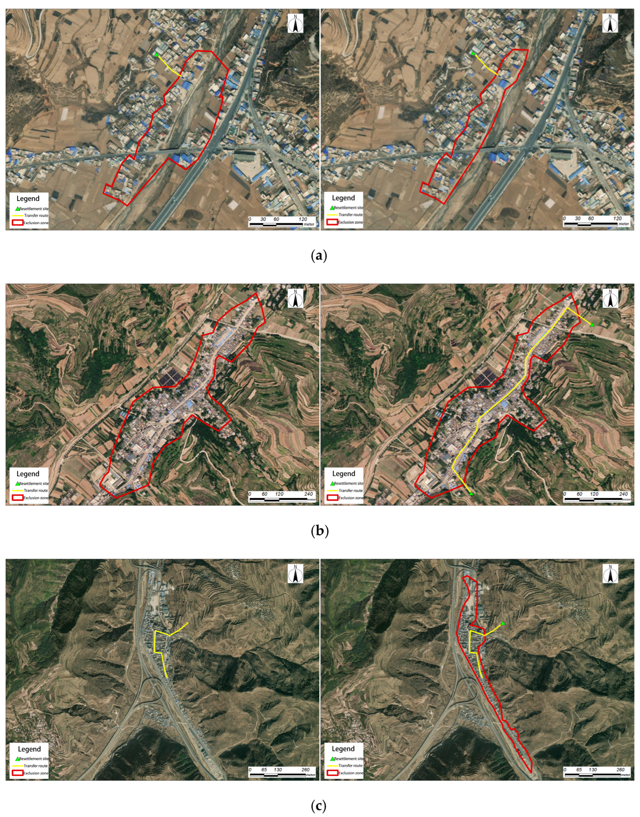
4.2. Hazard Zone Classification

The classification of hazard zones should comprehensively consider local rainfall and flood characteristics, housing types, population distribution, the current flash flood defense and flood control capacity, and historical disaster data [17]. If there are unfavorable factors, such as river sedimentation or damming, that exacerbate flash flood risks, the risk level of the hazard zone should be raised. The audit of hazard zones should focus more on the macro perspective, including statistics on the proportion of total hazard zones to key towns and villages, the proportion of hazard zones that have been mapped, and the proportion of evaluated hazard zones. The audit should also evaluate whether the on-site surveys cover all areas and assess the rationality of the evaluation work and classification of hazard zones. Meanwhile, the rationality of the layer positions of hazard zones, evacuation routes, and shelter locations should be evaluated using remote sensing imagery, specifically focusing on factors such as population density within hazard zones, avoiding river crossings on evacuation routes, and ensuring that shelter locations are not susceptible to flooding. Specific issues to address include the following:
(1)
The scope of the hazard zone is unreasonable (cutting through houses, spanning rivers, etc.);
(2)
There is a standalone hazard zone without evacuation routes or shelter locations;
(3)
The starting point of the evacuation route is not connected to the hazard zone (i.e., they are relatively far apart);
(4)
The evacuation route does not follow roads, cuts through houses, or crosses rivers;
(5)
There are evacuation routes without connected hazard zones or shelter locations;
(6)
The shelter location is unreasonable, either still within the hazard zone or too far away;
(7)
There is a shelter location without a hazard zone or evacuation routes.
The actual audit statistics suggest that the addition of the professional audit guidelines for hazard zone classification resulted in an average national issue detection rate of 5%. The specific details are shown in the figure below (Figure 4).

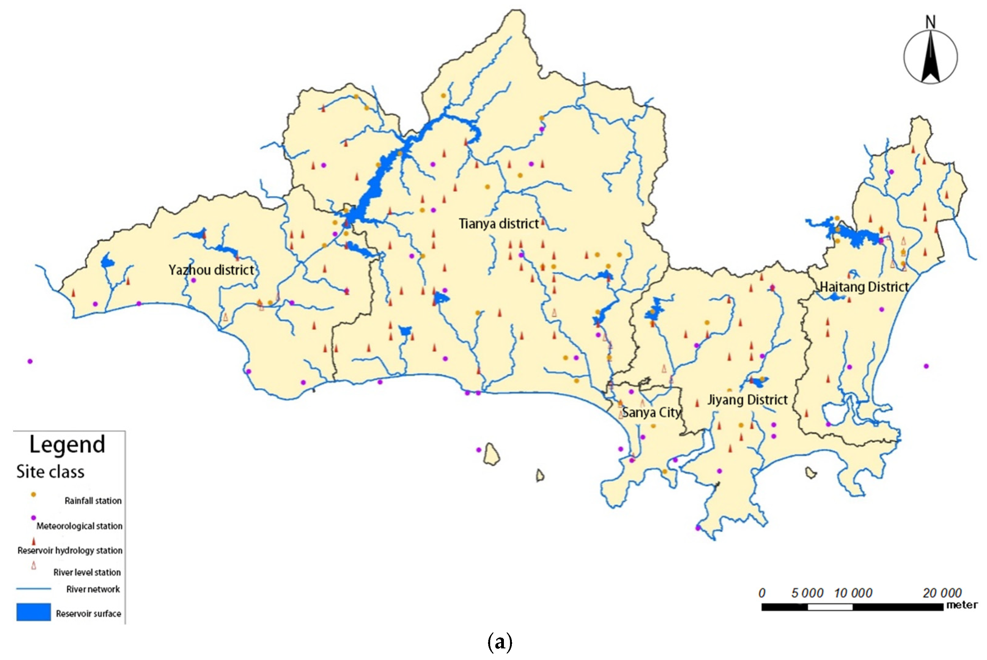
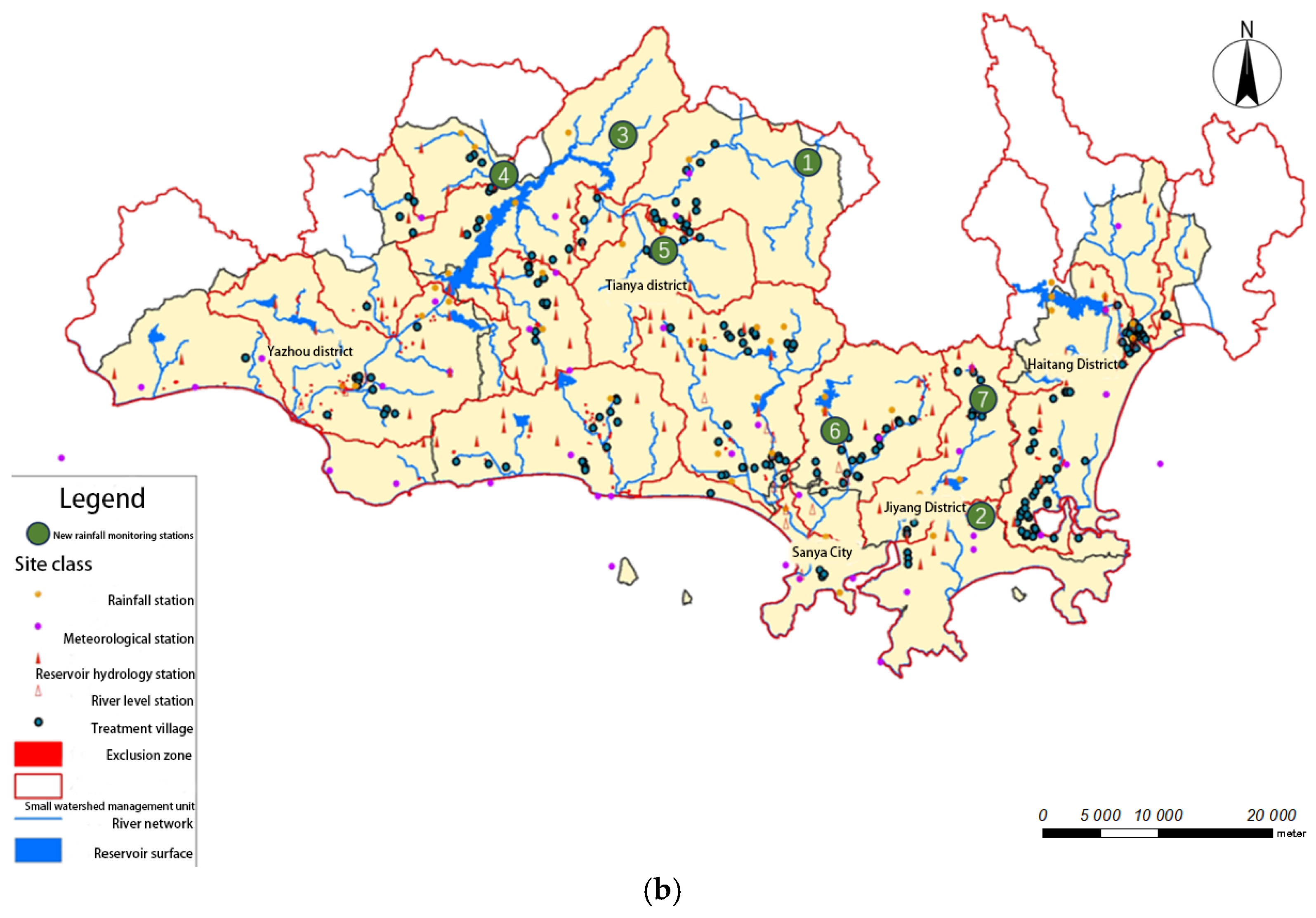
4.3. Monitoring Facility Analysis

The monitoring facilities include automated stations, such as rain gauges, water level stations, hydrological stations, and meteorological stations. Monitoring blind spots were identified by analyzing the density of these stations in the upstream catchment areas of small watershed units. Based on the risk levels, high-risk areas should have a density of no less than 25 km2/station, while other areas should maintain a density of no less than 80 km2/station. Additionally, the relationship between monitoring stations and significant towns should be audited. The representativeness and scientific validity of these relationships were automatically assessed using GIS technology, according to the following principles:
(1)
Monitoring stations should be located in the upper or middle reaches of watersheds with key towns or in their upstream areas.
(2)
Stations should be within a 5 km radius.
(3)
A single monitoring station may serve multiple key towns.
(4)
A single key town may be associated with multiple monitoring stations.
(5)
Coordination should be achieved among flood, hydrological, meteorological, and reservoir stations within the watershed.
(6)
Effective relationships should be established among the stations, early warning indicators, protection targets, and small watersheds.
Figure 5a,b demonstrate the implementation outcomes after incorporating the new professional audit criteria for monitoring facility associations. The case study area is Sanya City, which currently has 47 rain gauge stations. The Thiessen polygon method was used to analyze the control areas of each station. The control area for the rain gauge network ranges from 0.2 to 74.14 km2, with an average density of 10.19 km2/station, which is significantly higher than the national average level (38 km2/station). Nevertheless, there are still some rainfall monitoring blind spots within the flood prevention zones, and the spatial layout of the rain gauge stations is still suboptimal, requiring further optimization.
Taking the newly added rainfall monitoring station 1 in Figure 5b as an example, the original stations in this area were Zanan Station, Liuluo Village Station, and Zhian Station, with control areas of 74.1 km2/station, 50.91 km2/station, and 42.1 km2/station, respectively. These values are lower than the national average density for automatic rainfall stations (38 km2/station). According to the analysis results of the control areas of each station using the Thiessen polygon method, which is based on the current distribution of automatic monitoring stations, it is recommended to add more rainfall monitoring stations. This recommendation is in accordance with the evaluation principle that the control area should not be less than the national average density for automatic rainfall stations (38 km2/station). Additionally, there are no rainfall monitoring stations in the area or upstream of the watershed where the warning target Baotu Village is located, creating a rainfall monitoring blind spot. According to the evaluation principle for setting up monitoring stations in the upper and middle reaches of the watershed where the warning target is located, it is necessary to add a new rainfall monitoring station (i.e., station 1). After the addition of this station, the control areas of Zanan Station, Liuluo Village Station, and Zhian Station will be 33.2 km2/station, 36.9 km2/station, and 20.1 km2/station, respectively, which improves upon the national average density for automatic rainfall stations (38 km2/station). Meanwhile this addition will enhance the rainfall monitoring capacity in the watersheds of two key prevention and control targets (i.e., Baotu Village (priority target) and the Baotu hazardous area). This case demonstrates that the ability to monitor mountain flood disasters in hazardous areas can be significantly improved when considering the correlation of monitoring facilities following the professional audit guidelines.

5. Discussion

Through comparative research on the investigation and evaluation methods of mountain flood disasters in different places, this study innovatively proposes professional review rules for early warning indicators, the correlation of monitoring facilities, the classification of danger areas, and other aspects, focusing on the investigation and evaluation of mountain flood disasters and their data review and quality control, aiming to improve the scientific foundation and effectiveness of mountain flood disaster prevention work. Through systematic data collection and analysis, Beizhen City provides a key scientific basis for flood control and disaster reduction [18]. Guangdong Province used the audit collection system to carry out software-based automatic audits and manual rationality audits on the data. The investigation was complete, and the main results of the analysis and evaluation were overall in line with the local reality [19]. Liaoning Province ensured the scientific and accurate data through post-control, process control, and link control measures [20]. Yunnan Province has ensured data quality through a project pilot, business training, and technical control and other measures, providing a decision-making basis for mountain flood disaster prevention [21]. At present, various research methods are used for the investigation and evaluation of mountain flood disasters, including field investigation and data review [22], the application of information technology [23], etc., which help ensure data accuracy and completeness. The results show that through systematic data collection and analysis, combined with advanced technical means, the quality and application value of mountain flood disaster investigations and evaluations can be significantly improved. These studies provide important theoretical and technical support for national mountain flood disaster prevention and control and lay a solid foundation for scientific mountain flood disaster prevention.
Although this study has introduced specialized verification guidelines to improve the quality of data after verification, some limitations still exist. Firstly, the timeliness of verification remains insufficient, as it is not possible to effectively distinguish data from different time periods, which affects the establishment of a long-term mechanism. Secondly, the precision of verification has not been fully addressed, as small discrepancies in indicators are still difficult to identify accurately, thus affecting the precision of the data. Furthermore, the current verification method still relies on manual auxiliary tools and has not yet incorporated automated verification technologies based on deep learning or machine learning, which limits the efficiency of the verification process and data handling capabilities. Therefore, future research should further strengthen the timeliness and precision of data verification and incorporate advanced technological methods to enhance the overall data quality and verification effectiveness.
Machine learning can improve risk prediction, and big data can support real-time monitoring and dynamic decision making. Some further improvements can be made on the basis of the significant achievements of the improved audit methodology in the following areas. First, it is essential to further refine the audit standards for different types of data (e.g., data of monitoring stations, water-related projects, and historical disaster records). In particular, regarding data with complex topological relationships and multiple dimensions, more precise audit rules and automated validation tools can be introduced to enhance the audit efficiency and accuracy. Additionally, leveraging artificial intelligence and big data analytics technologies can facilitate the automatic detection and correction of anomalies, gaps, and logical inconsistencies in the data, which can enable smarter and more dynamic data audit processes, improving both precision and timeliness. Additionally, it is necessary to strengthen data sharing and collaborative audit mechanisms across national-, provincial-, municipal-, and county-level departments, which can break down hierarchical barriers and ensure the continuity and consistency of audit outcomes [24]. Moreover, integrating data from relevant departments, such as the meteorological department and emergency management department, can contribute to developing a more comprehensive disaster prevention and early warning system. Lastly, a dynamic update mechanism should be established as mountain flood disaster prevention projects progress and more new disaster prevention information is collected. This would involve regularly auditing and updating the existing audit results while also enhancing the tracking and evaluation of the implementation outcomes of subsequent flood prevention measures to ensure the sustainable effectiveness of the audit data.

6. Conclusions

Surveys and evaluations of key towns and villages in mountain flood disaster areas based on systematic data collection and analysis can provide crucial scientific evidence for flood prevention and disaster reduction. This approach enables the effective optimization of decision making and resource allocation, enhancing the accuracy and effectiveness of disaster mitigation measures. This evaluation work not only contributes to the development of the national mountain flood disaster prevention system but also improves the accuracy and timeliness of monitoring and early warning. As a result, disaster prevention and reduction work can become more proactive and forward-thinking, significantly enhancing the ability of key towns to respond to extreme climate change and mountain flood disaster risks. However, traditional audit methods are inadequate for comprehensively and accurately assessing the quality and consistency of the national survey and evaluation data of key towns in mountain flood disaster areas due to their highly specialized nature, large volume, diverse types, and complex topological relationships [25]. This situation exposes a series of issues in the audit process, e.g., inadequate hierarchical audit implementation, insufficient audit efforts at the provincial, municipal, or county levels, delays in addressing identified issues, and the unnecessary inclusion of problems that should be resolved at lower levels in the central audit process. These issues have resulted in numerous errors in the data entered into the dataset, and a large number of corrections were required.
This study incorporated some new audit rules, e.g., early warning indicator analysis, hazard zone classification, and monitoring facility association analysis. Additionally, we systematically analyzed and integrated the audit contents at the national, provincial, municipal, and county levels based on the results of the first national mountain flood disaster survey and evaluation. This study applied the improved audit method to the data audit of the national mountain flood disaster survey and evaluation at the central level. The results show that this method not only achieved a significant breakthrough but also significantly improved the audit quality, advancing the audit results from preliminary improvement to higher standards [26]. This improved audit method effectively improved early warning accuracy, reduced false reports, and further enhanced the rationality and reliability of mountain flood disaster prevention efforts. The national mountain flood disaster prevention project team adopted a data audit method that combines a software-based automatic audit approach from a data warehouse with manual interpretation. Following the improved audit rules described in this paper and utilizing ETL technology to conduct more than five rounds of data audit, the team effectively identified issues in the data and achieved the goal of data quality control. Currently, the results of the surveys and evaluations of key towns in mountain flood disaster areas have largely passed the audit process and entered the project acceptance phase, effectively supplementing the national mountain flood disaster survey and evaluation database and providing reliable data support for mountain flood disaster prevention work. The audit rules proposed in this study are also applicable to regions such as Southeast Asia and South America, where the mountainous terrains face similar flood risks.

Author Contributions

Conceptualization, M.X. and S.Q.; methodology, Y.D.; software, X.Z.; validation, M.X. and S.Q.; formal analysis, M.X.; investigation, Y.D.; resources, X.Z.; data curation, X.Z.; writing—original draft preparation, Y.D.; writing—review and editing, M.X.; visualization, S.Q.; supervision, X.Z.; project administration, M.X.; funding acquisition, Y.D. All authors have read and agreed to the published version of the manuscript.

Funding

This research received no external funding.

Data Availability Statement

The data presented in this study are available on request from the corresponding author. The data are not publicly available due to privacy.

Conflicts of Interest

The authors declare no conflict of interest.

References

  1. Stamos, I.; Diakakis, M. Mapping Flood Impacts on Mortality at European Territories of the Mediterranean Region within the Sustainable Development Goals (SDGs) Framework. Water 2024, 16, 2470. [Google Scholar] [CrossRef]
  2. Nederhoff, K.; Crosby, S.C.; Van Arendonk, N.R.; Grossman, E.E.; Tehranirad, B.; Leijnse, T.; Klessens, W.; Barnard, P.L. Dynamic Modeling of Coastal Compound Flooding Hazards Due to Tides, Extratropical Storms, Waves, and Sea-Level Rise: A Case Study in the Salish Sea, Washington (USA). Water 2024, 16, 346. [Google Scholar] [CrossRef]
  3. Guo, L.; Ding, L.; Kuang, S.; Wang, X.; Sun, D.; Li, C.; Xie, J.; Liu, C.; He, B.; Liu, R.; et al. Key Technologies and Applications for Investigation and Evaluation of Flash Flood Disasters in China. China Flood Control Drought Relief 2018, 28, 7–11+32. [Google Scholar]
  4. Yin, Y.; Peña, M. An Imputing Technique for Surface Water Extent Time Series with Streamflow Discharges. Water 2024, 16, 250. [Google Scholar] [CrossRef]
  5. Guo, J. Survey and Evaluation Methods of Mountain Flood Disaster and Analysis of Quality Control Measures in Beizhen City. Undergr. Water 2018, 40, 211–212. [Google Scholar] [CrossRef]
  6. Feng, A.; Guo, M.; Lv, Z. Methods and Procedures for Investigation and Evaluation of the “Three Rates” (Recovery Rate, Utilization Rate, and Comprehensive Utilization Rate) of Important Mineral Resources in China. Mineral Resources Protection and Utilization. 2016. Available online: www.minerals.com (accessed on 12 February 2025).
  7. Porębska, A.; Muszyński, K.; Godyń, I.; Racoń-Leja, K. City and Water Risk: Accumulated Runoff Mapping Analysis as a Tool for Sustainable Land Use Planning. Land 2023, 12, 1345. [Google Scholar] [CrossRef]
  8. Antwi-Agyakwa, K.T.; Afenyo, M.K.; Angnuureng, D.B. Know to Predict, Forecast to Warn: A Review of Flood Risk Prediction Tools. Water 2023, 15, 427. [Google Scholar] [CrossRef]
  9. Zhu, X.; Xiao, B. Preliminary Exploration of Dynamic and Hierarchical Management of Flash Flood Hazard Zones in Sichuan Province. China Flood Control Drought Relief 2021, 3, 20–22+33. [Google Scholar] [CrossRef]
  10. Manfreda, S.; Samela, C.; Refice, A.; Tramutoli, V.; Nardi, F. Advances in Large-Scale Flood Monitoring and Detection. Hydrology 2018, 5, 49. [Google Scholar] [CrossRef]
  11. Scholz, M.; Yang, Q. Novel Method to Assess the Risk of Dam Failure. Sustainability 2011, 3, 2200–2216. [Google Scholar] [CrossRef]
  12. Ye, J.; Bai, Y.; Xu, J.; Huang, S.; Han, Z.; Wan, W. Public Authentic-Replica Sampling Mechanism in Distributed Storage Environments. Electronics 2024, 13, 4167. [Google Scholar] [CrossRef]
  13. Wei, X. Supporting Refined Management through Hazard Zone Classification and Gaining Proactive Prevention through Progressive Warnings. China Water Resources News, 6 July 2023. [Google Scholar] [CrossRef]
  14. Sanda, M.-R.; Siminică, M.-I.; Avram, C.-D.; Popescu, L. Ghosts in the Machine: How Big Data Analytics Can Be Used to Strengthen Online Public Procurement Accountability. Sustainability 2024, 16, 3698. [Google Scholar] [CrossRef]
  15. Zhang, P.; Sun, X.; Peng, H. Summary and Suggestions on Integration and Review of Mountain Flood Disaster Investigation and Evaluation in Guangdong Province. China Flood Drought Manag. 2019, 29, 20–23. [Google Scholar]
  16. Zhou, D.; Lu, G.; Jiang, Z. Research on Quality Control of Mountain Flood Disaster Investigation and Evaluation Results in Liaoning Province. Flood Control Drought Relief China 2017, 27, 64–66. [Google Scholar] [CrossRef]
  17. Wang, D.; Yuan, S.; Yang, C.; Zhu, X.; Luo, L. Summary of Investigation and Evaluation of Mountain Flood Disaster in Yunnan Province. Flood Control Drought Relief China 2018, 28, 40–43+47. [Google Scholar] [CrossRef]
  18. Yao, L.L. Application of Information Technology in Mountain Flood Disaster Investigation and Evaluation. Appl. Technol. Soil Water Conserv. 2017, 3, 25–27. [Google Scholar]
  19. Feng, A.-S.; Guo, M.; Lu, Z. Methods and procedures of “three rates” survey and evaluation of national important mineral resources. Miner. Prot. Util. 2016, 5, 1–4. [Google Scholar] [CrossRef]
  20. Que, B.M. Research on Implementation and Management of Mountain Flood Disaster Prevention Project in Guangxi. Master’s Thesis, Guangxi University, Nanning, China, 2014. (In Chinese). [Google Scholar]
  21. Yao, C. Summary analysis of mountain flood disaster investigation, evaluation and review in Hebei. Inn. Mong. Water Resour. 2019, 6, 59–60. [Google Scholar]
  22. Li, H. Design of data review and collection system for mountain flood disaster investigation and Evaluation. J. Inn. Mong. Univ. Natl. 2016, 31, 213–215. [Google Scholar] [CrossRef]
  23. Huang, X.; Chu, M.; Shi, J. Analysis on investigation and evaluation of mountain flood disaster in China. China Water Resour. 2015, 9, 17–18+29. [Google Scholar]
  24. An, T.-H. Five Achievements helping to upgrade the level of mountain flood disaster prevention and control: An overview of the results of the national Mountain Flood Disaster investigation and evaluation project. China Water Resour. 2019, 3, 6–11. [Google Scholar]
  25. Liu, D. Bei Town city mountain torrent disaster survey evaluation audit analysis. J. Heilongjiang Prov. Water Conserv. Sci. Technol. 2018, 46–48, 180–181. [Google Scholar]
  26. Liu, Y.S. Evaluation of Spatial and Temporal Distribution Pattern and Driving Force Heterogeneity of Mountain Flood Disasters in China. Ph.D. Thesis, Tianjin University, Tianjin, China, 2017. [Google Scholar]
Figure 1. Schematic diagram of main contents of survey and evaluation of key towns and villages.
Water 17 00773 g001
Figure 2. Schematic diagram of audit contents of survey and evaluation results for key towns and villages.
Water 17 00773 g002
Figure 3. Comparison of early warning indicators and flood control capacity for key towns in mountainous regions, below a 100-year return period.
Water 17 00773 g003
Figure 4. Schematic illustration of a case for implementing professional audit rules into hazard zone classification. (a) Hazard zone crossing before and after modifications. (b) Comparison between conditions before and after modification of no-transfer routes and settlements in hazard zones. (c) Comparison of conditions before and after modification of hazard zones and settlements without connection to diversionary routes.
Water 17 00773 g004
Figure 5. Effects of implementing the monitoring facility association audit rules. (a) shows the rain measuring station in Sanya City. (b) shows the implementation effect of the new professional audit rules that take into account the monitoring of facility linkages.
Water 17 00773 g005aWater 17 00773 g005b
Table 1. Attribute table of results for key cities and market towns.
Serial NumberTable NameSerial NumberTable Name
1Analyzing the evaluation directory9Hazardous area basics
2Designing for rainstorms10Historical flash floods
3Control section design flood11Automatic monitoring stations, wireless early warning broadcasting stations, simple rainfall stations, simple rainfall stations
4Evaluation of the current state of flood control12Reservoirs, sluices, embankments, ponds (weirs), and dam works in the control area
5Critical rainfall empirical estimation method, critical rainfall analysis method, critical rainfall modeling analysis method results (1 of 3)13Road culvert and bridge works
6Early warning indicators14Survey of residents of important towns and cities
7General information on administrative divisions15Multimedia
8Basic information on the prevention and control area16Ditch longitudinal cross-section, historical flood scar measurement
Table 2. Attribute table of spatial data.
Serial NumberChinese NameSerial NumberChinese Name
1Administrative subdivision (e.g., map layer)12Simple water level station layer
2Residential settlement contour layer13Layer of pond (weir) project
3Enterprise layers14Road culvert engineering layers
4Hazardous area layer15Bridge engineering layers
5Settlement layer16Reservoir engineering layers
6Transfer roadmap layer17Layers for sluice gate engineering
7Historical flash flood layers18Embankment engineering layers
8Layers of flood management gullies in need of flood control19Layer of households in important urban agglomerations
9Automatic monitoring station layer20Trench longitudinal section layer
10Wireless early warning broadcasting station layer21Trench cross-section layer
11Simple rainfall station layer22Historical flood trace measurement points layer
Table 3. Comparison of the effects of professional audit rules on the analysis of early warning indicators.
Analysis of Early Warning IndicatorsNational Average Problem Detection RateHighest Problem Detection Rate by Province
Before an AuditAfter an AuditDifference (Result of Subtraction)Before an AuditAfter an AuditDifference (Result of Subtraction)
Logical Relationship is Reasonable4%0%4%22%0%22%
Comparison with design storm1 h
Early warning indicators
Less than 5 years57%52%5%96%76%20%
50 years or more4%5%1%0%16%16%
3 h
Early warning indicators
Less than 5 years36%34%2%24%7%18%
50 years or more4%6%2%6%17%11%
6 h
Early warning indicators
Less than 5 years31%30%1%57%39%18%
50 years or more4%6%2%1%20%19%
Disclaimer/Publisher’s Note: The statements, opinions and data contained in all publications are solely those of the individual author(s) and contributor(s) and not of MDPI and/or the editor(s). MDPI and/or the editor(s) disclaim responsibility for any injury to people or property resulting from any ideas, methods, instructions or products referred to in the content.

