Multi-Objective Water Allocation for Wu’an City

Abstract

1. Introduction
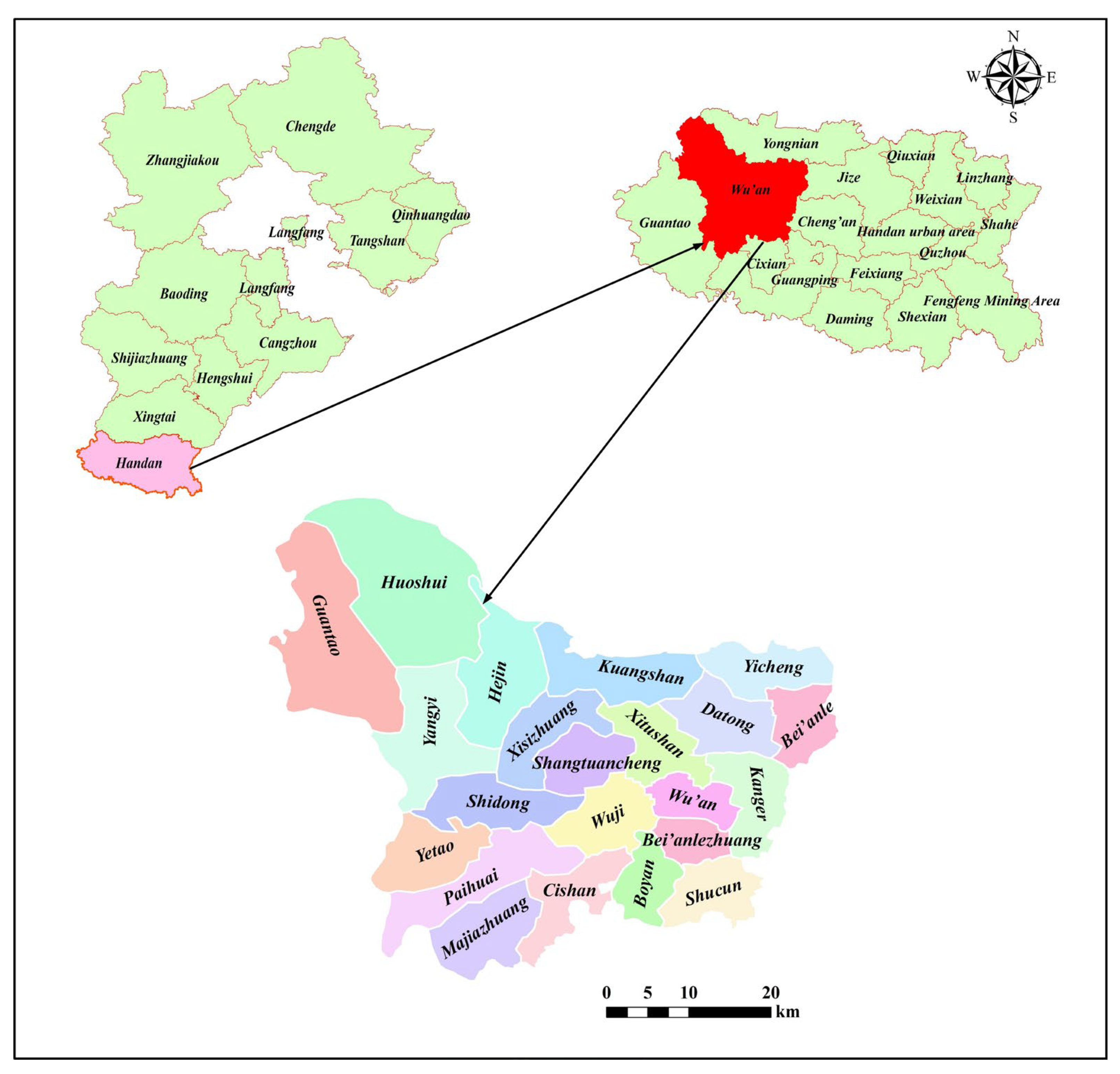
2. Study Area
3. Data Sources
4. Methods
4.1. Calculation of Rigid Water Demand and Total Water Demand Thresholds for Wu’an City
4.1.1. Domestic Water Demand
4.1.2. Industrial Water Demand
4.1.3. Agricultural Water Demand
4.1.4. Ecological Water Demand
4.2. Calculation of Available Water Supply from Multi-Water Sources
4.2.1. Available Surface Water Supply
4.2.2. Available Groundwater Supply
4.2.3. Available Mine Drainage Water Supply
4.2.4. Calculation of Available Reclaimed Water Supply
4.3. Construction of a Multi-Water Source and Multi-Objective Collaborative Configuration Model
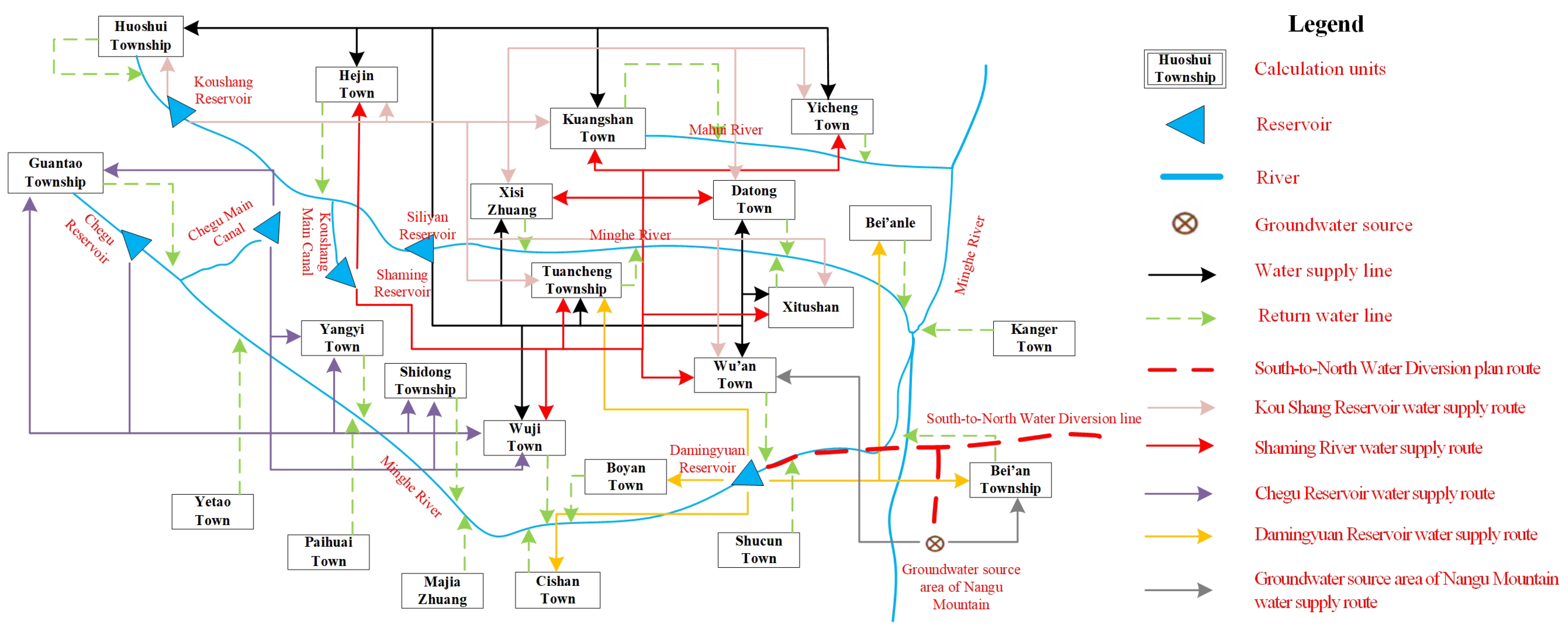
4.3.1. Water Resource Allocation Network
4.3.2. Quantification of Water Supply and Consumption Priority
4.3.3. Objective Function
- (1)
- Economic benefit objective
- (2)
- Social benefit objective
- (3)
- Ecological benefits
4.3.4. Constraints
- (1)
- Constraints include water resource allocation rules, water supply balance, water supply capacity, total water consumption, water consumption for ten thousand yuan GDP, water consumption for ten thousand yuan industrial added value, and non-negative solution.
- (2)
- Constraints of water supply balance
- (3)
- Constraints of water supply capacity
- (4)
- Constraints of total water consumption
- (5)
- Constraint of water consumption for ten thousand yuan of GDP
- (6)
- Constraints of water consumption for ten thousand yuan of industrial added value
- (7)
- Non-negative solution constraints
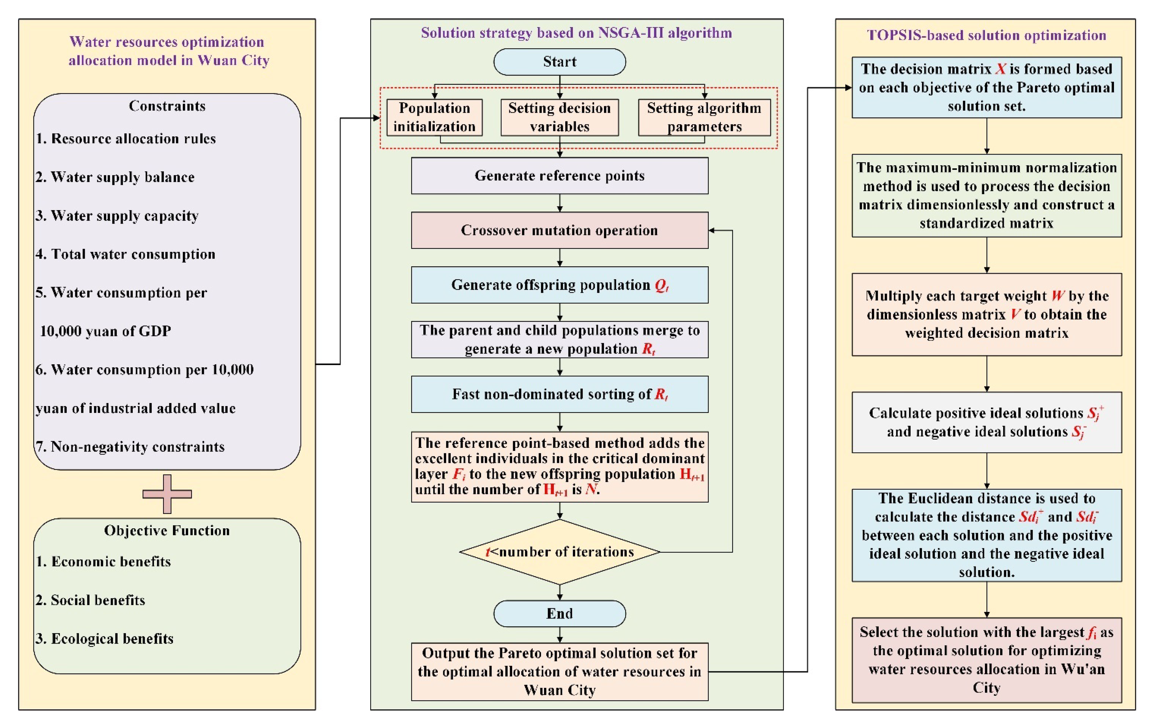
4.3.5. Method for Determining Water Resource Optimal Allocation Scheme Based on NSGA-III Algorithm and TOPSIS
- (1)
- Construction of a water resource optimization allocation model in Wu’an City:
- Define the objective function of the model, that is, the optimization of economic, social, and ecological benefits.
- To ensure the rationality and feasibility of the configuration plan, set constraints, including water resource allocation rules, water supply balance analysis, water supply capacity assessment, total water use control, water use limit per CNY 10,000 of GDP, water use index per CNY 10,000 of industrial added value, and non-negative constraints.
- Construct the Wu’an City water resource optimization configuration model based on the objective function and constraints.
- (2)
- Solution strategy based on the NSGA-III algorithm:
- (3)
- TOPSIS-based solution optimization:
- ① The smaller the better the target:
- ② The bigger the better type of goal:
5. Results and Analysis
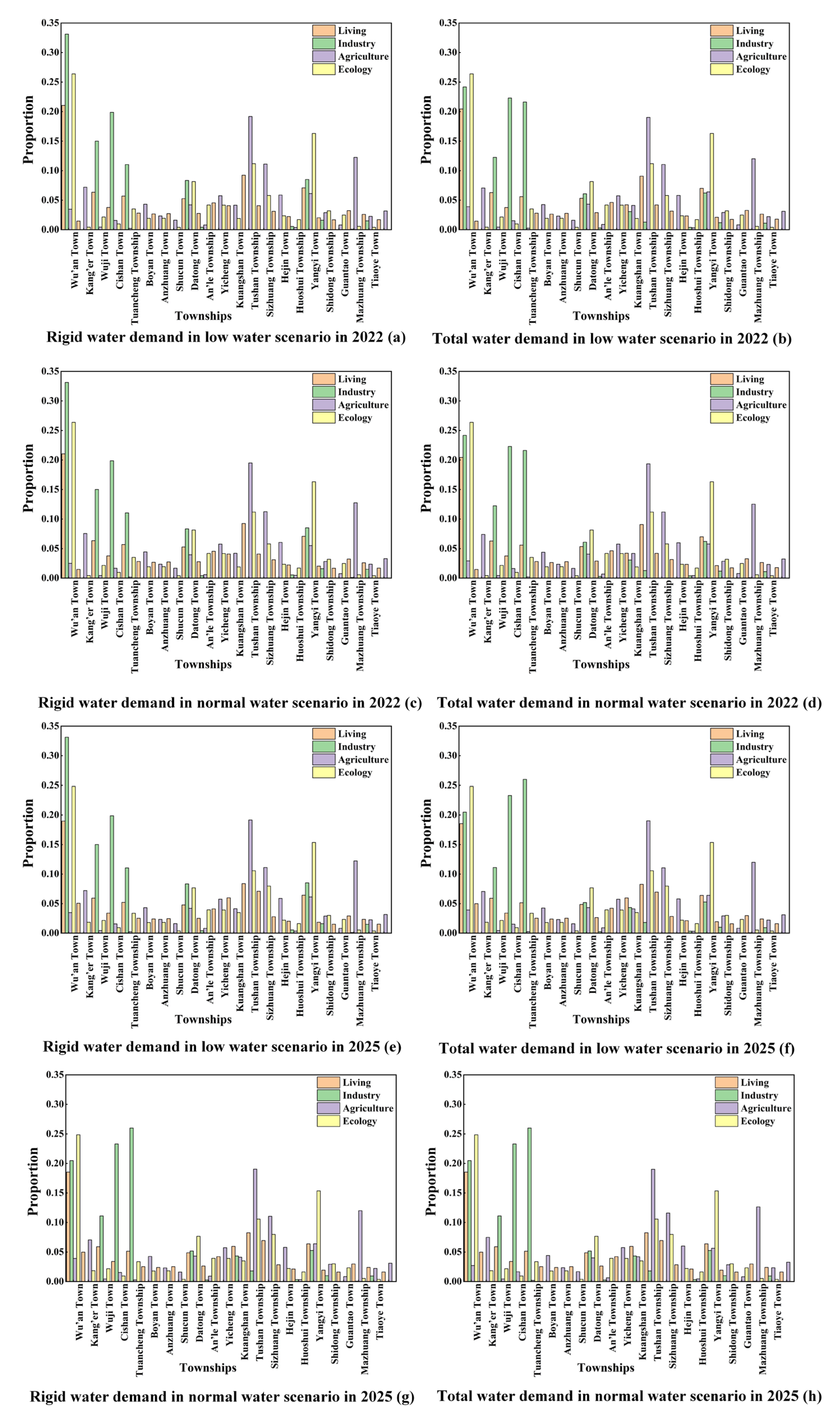
5.1. Water Demand Thresholds by Industry in Base and Planning Years
5.2. Available Water Supply from Different Water Sources in Base and Planning Years
5.3. Results of Multi-Water Source and Multi-Objective Collaborative Configuration
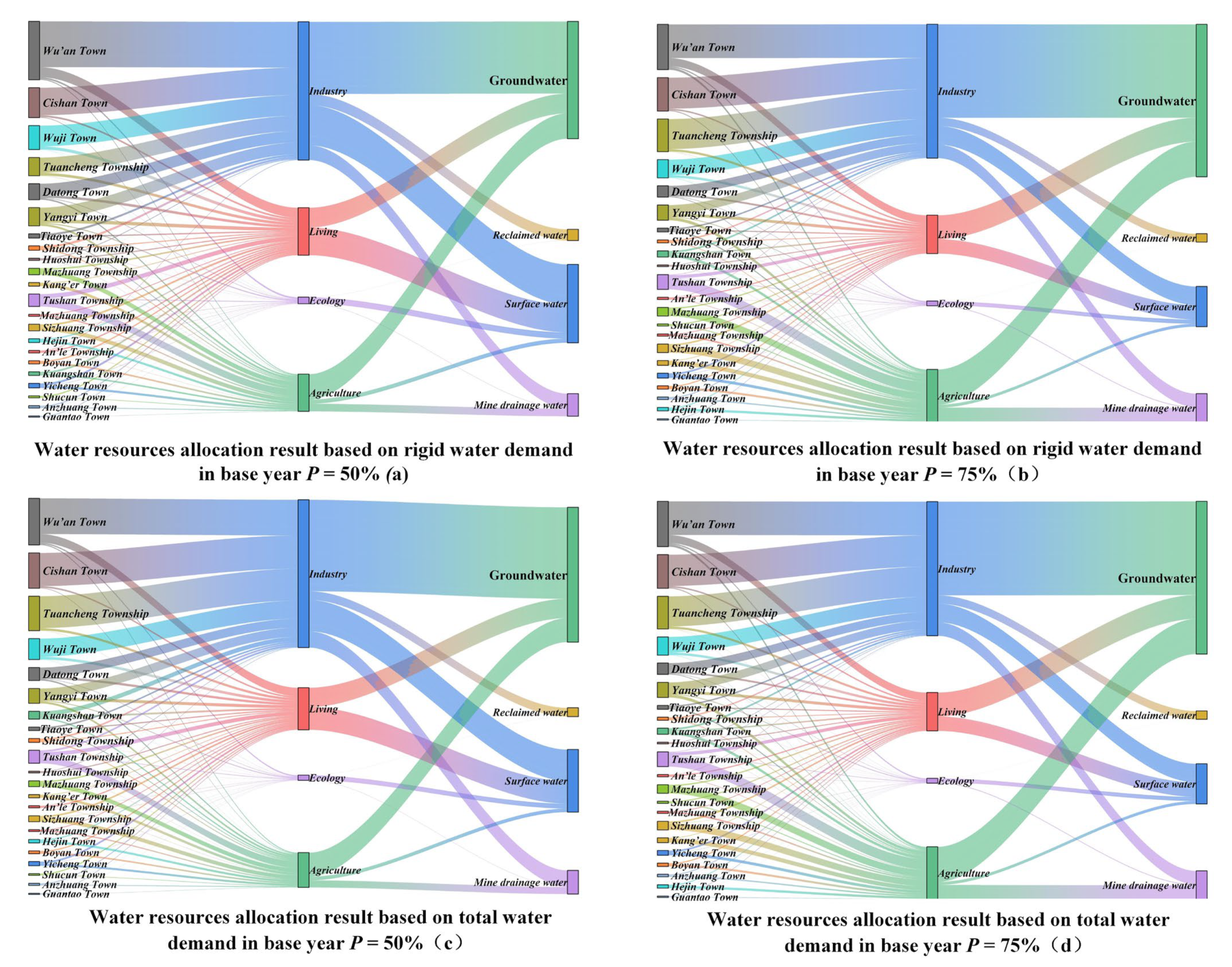
5.3.1. Results of Multi-Water Source and Multi-Objective Collaborative Configuration in the Base Year
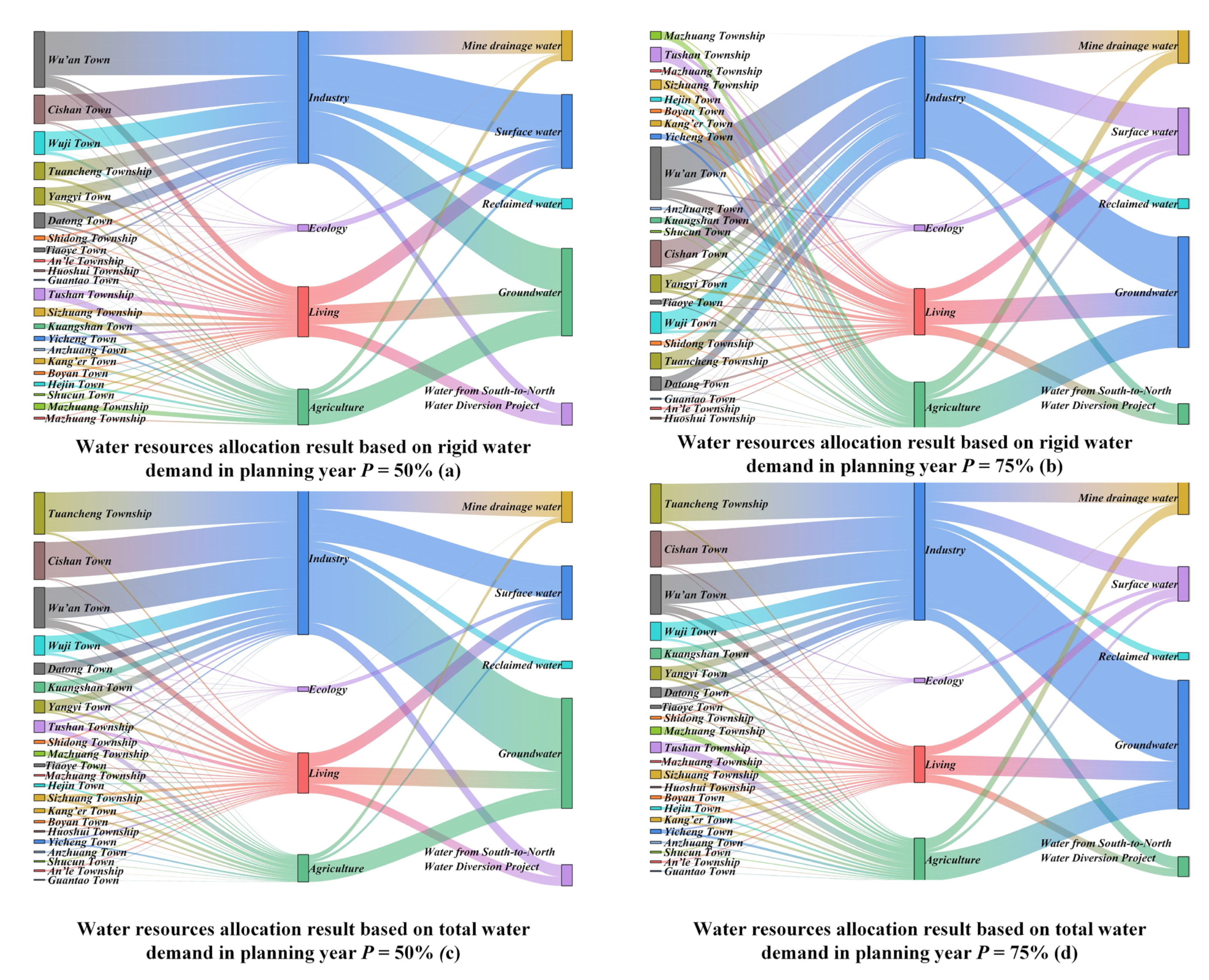
5.3.2. Multi-Water Source and Multi-Objective Collaborative Configuration Results in the Planning Year
6. Discussion
6.1. Model Performance Analysis
6.2. Analysis of Research Results
6.3. Research Value Analysis
6.4. Countermeasures and Recommendations
6.5. Limitations and Prospects
7. Conclusions
- (1)
- By analyzing the water demand and supply of Wu’an City between 2022 and 2025, it is found that the rigid water demand and total water demand of Wu’an City show an increasing trend in both normal and low water scenarios, but the demand in 2025 is still within the most stringent water resource management red line. At the same time, the assessment of water supply capacity from multiple water sources shows that the water supply capacity of Wu’an City is increasing year by year, reaching 229.9835 million m3 in normal water scenario and 213.9587 million m3 in low water scenario in 2025, which provides strong support for the efficient use and sustainable management of water resources.
- (2)
- With economic, social, and ecological benefits as the objective function, and water resource allocation rules, water supply balance, water supply capacity, total water use, water use per CNY 10,000 of GDP, water use per CNY 10,000 of industrial added value, and non-negative as constraints, a water resource optimization allocation model was constructed, and the model was solved using the NSGA-III algorithm to obtain the Pareto optimal solution set. Based on this, the TOPSIS decision method was used to select the optimal solution in the Pareto optimal solution set, thereby determining the optimal water resource optimization allocation plan while achieving a balance between water supply and demand and improving economic, social, and ecological benefits.
- (3)
- The results of water resource allocation show that under the normal water scenario, Wu’an City can fully meet the rigid and total water demand in 2022 and 2025, and both social and ecological benefits are optimal. The net economic benefit under the normal water scenario increased by CNY 933.044 million, and the net economic benefit was significant. Under the low water scenario, despite the challenge of water shortage, Wu’an City can still maintain high water supply equity (the Gini coefficient is less than 0.2) through reasonable allocation, and the ecological water demand is fully guaranteed. The social and ecological benefits are maintained at a low level. Although the economic benefits have declined, they still achieve an increase of CNY 100.130 million in 2025 compared with 2022, indicating that the water resource management strategy has a certain resilience in coping with drought.
- (4)
- In response to the water shortage problem in Wu’an City, a water resource management strategy of “increasing revenue and reducing expenditure” should be adopted: introducing external water to alleviate the contradiction between supply and demand, upgrading water supply facilities to reduce water resource loss, developing unconventional water sources such as mine drainage water to increase the utilization rate of recycled water, building rainwater collection facilities in arid areas, using abandoned reservoirs to store flood water, and enhancing regional regulation and storage capacity.
Author Contributions
Funding
Data Availability Statement
Conflicts of Interest
References
- Lu, C.; Ji, W.; Hou, M.; Ma, T.; Mao, J. Evaluation of efficiency and resilience of agricultural water resources system in the Yellow River Basin, China. Agric. Water Manag. 2022, 266, 107605. [Google Scholar] [CrossRef]
- Issaoui, M.; Jellali, S.; Zorpas, A.A.; Dutournie, P. Membrane technology for sustainable water resources management: Challenges and future projections. Sustain. Chem. Pharm. 2022, 25, 100590. [Google Scholar] [CrossRef]
- Song, M.; Tao, W.; Shang, Y.; Zhao, X. Spatiotemporal characteristics and influencing factors of China’s urban water resource utilization efficiency from the perspective of sustainable development. J. Clean. Prod. 2022, 338, 130649. [Google Scholar] [CrossRef]
- Zhou, F.; Zhang, W.; Jiang, A.; Peng, H.; Li, L.; Deng, L.; Sun, Y.; Wang, H. Spatial-temporal variation characteristics and coupling coordination of the “water resources–water environment–water ecology” carrying capacity in the Three Gorges Reservoir Area. Ecol. Indic. 2023, 154, 110874. [Google Scholar] [CrossRef]
- Ingrao, C.; Strippoli, R.; Lagioia, G.; Huisingh, D. Water scarcity in agriculture: An overview of causes, impacts and approaches for reducing the risks. Heliyon 2023, 9, e18507. [Google Scholar] [CrossRef]
- Hu, Z.; Chen, Y.; Yao, L.; Wei, C.; Li, C. Optimal allocation of regional water resources: From a perspective of equity–efficiency tradeoff. Resour. Conserv. Recycl. 2016, 109, 102–113. [Google Scholar] [CrossRef]
- Li, X.; Wang, X.; Guo, H.; Ma, W. Multi-water resources optimal allocation based on multi-objective uncertain chance-constrained programming model. Water Resour. Manag. 2020, 34, 4881–4899. [Google Scholar] [CrossRef]
- Li, Y.; Sun, K.; Men, R.; Wang, F.; Li, D.; Han, Y.; Qu, Y. Study on the Optimization of Multi-Objective Water Resources Allocation in the Henan Yellow River Water Supply Zone. Water 2023, 15, 4009. [Google Scholar] [CrossRef]
- Roach, T.; Kapelan, Z.; Ledbetter, R. A resilience-based methodology for improved water resources adaptation planning under deep uncertainty with real world application. Water Resour. Manag. 2018, 32, 2013–2031. [Google Scholar] [CrossRef]
- Zhao, M.; Boll, J. Adaptation of water resources management under climate change. Front. Water 2022, 4, 983228. [Google Scholar] [CrossRef]
- Tesfaye, T. Optimal water allocation methods and policy under the current development and climate change challenges: A review on gidabo basin of Ethiopia. Ethiop. J. Eng. Technol. 2021, 1, 57–75. [Google Scholar]
- Wang, H.; You, J. Progress of water resources allocation during the past 30 years in China. J. Hydraul. Eng. 2016, 47, 265–271+282. [Google Scholar] [CrossRef]
- Ma, J.; Liu, H.; Wu, W.; Zhang, Y.; Dong, S. Research on optimal allocation of water resources in handan city based on the refined water resource allocation model. Water 2022, 15, 154. [Google Scholar] [CrossRef]
- He, H.; Chen, A.; Yin, M.; Ma, Z.; You, J.; Xie, X.; Wang, Z.; An, Q. Optimal allocation model of water resources based on the prospect theory. Water 2019, 11, 1289. [Google Scholar] [CrossRef]
- Fu, B.; Liu, J.; Zhang, J.; Wu, X.; Wang, J. Service accessibility of ecological nodes: An exploratory way to enhance network connectivity in a study case of Wu’an, China. Ecol. Inform. 2022, 69, 101589. [Google Scholar] [CrossRef]
- Zhang, J.; Rao, Y.; Geng, Y.; Fu, M.; Prishchepov, A.V. A novel understanding of land use characteristics caused by mining activities: A case study of Wu’an, China. Ecol. Eng. 2017, 99, 54–69. [Google Scholar] [CrossRef]
- Wu’an Statistics Bureau. Wu’an Statistical Yearbook; China Statistics Press: Beijing, China, 2018. [Google Scholar]
- Wu’an Statistics Bureau. Wu’an Statistical Yearbook; China Statistics Press: Beijing, China, 2019. [Google Scholar]
- Wu’an Statistics Bureau. Wu’an Statistical Yearbook; China Statistics Press: Beijing, China, 2020. [Google Scholar]
- Wu’an Statistics Bureau. Wu’an Statistical Yearbook; China Statistics Press: Beijing, China, 2021. [Google Scholar]
- Wu’an Statistics Bureau. Wu’an Statistical Yearbook; China Statistics Press: Beijing, China, 2022. [Google Scholar]
- Wu’an Water Conservancy Bureau. Wu’an Water Resources Bulletin; China Statistics Press: Wu’an, China, 2018. [Google Scholar]
- Wu’an Water Conservancy Bureau. Wu’an Water Resources Bulletin; China Statistics Press: Wu’an, China, 2019. [Google Scholar]
- Wu’an Water Conservancy Bureau. Wu’an Water Resources Bulletin; China Statistics Press: Wu’an, China, 2020. [Google Scholar]
- Wu’an Water Conservancy Bureau. Wu’an Water Resources Bulletin; China Statistics Press: Wu’an, China, 2021. [Google Scholar]
- Wu’an Water Conservancy Bureau. Wu’an Water Resources Bulletin; China Statistics Press: Wu’an, China, 2022. [Google Scholar]
- Diao, Z.; Zhao, J.; Han, Y.; Zhang, D.; Duan, J. Research on the hierarchical water demand of urban residents in Hebei Province. China Rural. Water Hydropower 2023, 1, 74–81. [Google Scholar] [CrossRef]
- Hebei Provincial Water Resources Department; Hebei Provincial Water Resources Research and Water Conservancy Technology Experimental Promotion Center. Water Quota for Living and Service Industry in Hebei Province” (DB 13/T 5450.1-2021), Hebei Provincial Market Supervision Administration; Hebei Provincial Water Resources Department: Shijiazhuang, China, 2021. [Google Scholar]
- Wu’an Municipal People’s Government. Outline of the 14th Five-Year Plan for National Economic and Social Development of Wu’an City and the Long-Term Goals for 2035. Available online: http://www.wuan.gov.cn/wasxxgk/zfxxgk/fdzdgkzml/ghxxx/gmjjx/202307/t20230710_1881729.html (accessed on 26 December 2024).
- National Bureau of Statistics; China National Institute of Standardization. Industrial classification for national economic activities. General Administration of Quality Supervision, Inspection and Quarantine of the People’s Republic of China; Administration of Standardization of the People’s Republic of China: Beijing, China, 2017. [Google Scholar]
- Li, Y. Research on the Rational Allocation of Water Resources Based on GWAS Model for Ecological Base Flow in the Ming River Basin. Master’s Thesis, Shijiazhuang Tiedao University, Shijiazhuang, China, 2023. [Google Scholar] [CrossRef]
- Wang, G.; Zhang, Q.; He, Y.; Ren, M.; Wang, K. Research on calculation of profit regulation of comprehensive utilization reservoir without data. China Flood Drought Manag. 2024, 34, 23–28. [Google Scholar] [CrossRef]
- Liu, Y.; Jiang, G.; Gao, W.; Wang, Q.; Yan, X. Homogeneous membrane electrodialysis in mine drainage water treatment. Membr. Sci. Technol. 2021, 41, 95–101. [Google Scholar] [CrossRef]
- Wu, Y.; Xu, J.; Liu, G.; Fang, Y.; Jiang, B. Occurrence characteristics and ecological risk assessment of antibiotics in reclaimed water replenishment rivers in Beijing. Environ. Sci. 2024, 45, 5244–5253. [Google Scholar] [CrossRef]
- Cui, Z.; Chang, Y.; Zhang, J.; Cai, X.; Zhang, W. Improved NSGA-III with selection-and-elimination operator. Swarm Evolut. Comput. 2019, 49, 23–33. [Google Scholar] [CrossRef]
- Ciro, G.C.; Dugardin, F.; Yalaoui, F.; Kelly, R. A NSGA-II and NSGA-III comparison for solving an open shop scheduling problem with resource constraints. IFAC-PapersOZnLine 2016, 49, 1272–1277. [Google Scholar] [CrossRef]
- Chakraborty, S. TOPSIS and Modified TOPSIS: A comparative analysis. Decis. Anal. J. 2022, 2, 100021. [Google Scholar] [CrossRef]
- Li, Y.; Han, Y.; Liu, B.; Li, H.; Du, X.; Wang, Q.; Wang, X.; Zhu, X. Construction and application of a refined model for the optimal allocation of water resources—Taking Guantao County, China as an example. Ecol. Indic. 2023, 146, 109929. [Google Scholar] [CrossRef]
- Luo, Y.; Sha, J.; Liu, B.; Zhang, Y.; Yang, J. Optimal allocation of water resources based on GWAS model in Handan, China. Water 2023, 15, 1090. [Google Scholar] [CrossRef]
- Hou, J.; Wang, N.; Luo, J.; Zuo, G.; Yang, L.; Xie, J. A dynamic allocation mechanism for formulating the allocation schemes of water resources. Water Supply 2023, 23, 996–1009. [Google Scholar] [CrossRef]
- Qu, Y.; Song, B.; Cai, S.; Rao, P.; Lin, X. Study on the Optimization of Wujiang’s Water Resources by Combining the Quota Method and NSGA-II Algorithm. Water 2024, 16, 359. [Google Scholar] [CrossRef]
- Menapace, A.; Avesani, D. Global gradient algorithm extension to distributed pressure driven pipe demand model. Water Resour. Manag. 2019, 33, 1717–1736. [Google Scholar] [CrossRef]
- Chang, D.E.; Lee, H.M.; Yoo, D.G.; Kim, J.H. Quantification of the head-outflow relationship for pressure-driven analysis in water distribution networks. KSCE J. Civ. Eng. 2019, 23, 3353–3363. [Google Scholar] [CrossRef]


| Test Function | - | NSGA-Ⅲ | NSGA-II | MOEA/D | GDE3 |
|---|---|---|---|---|---|
| DTLZ1 | MV | 2.301×10⁻² | 2.494×10⁻² | 3.149×10⁻² | 2.361×10⁻² |
| Rank | 1 | 3 | 4 | 2 | |
| SD | 3.199×10⁻⁴ | 1.195×10⁻³ | 3.594×10⁻² | 8.399×10⁻⁴ | |
| Rank | 1 | 3 | 4 | 2 | |
| DTLZ2 | MV | 5.531×10⁻² | 6.831×10⁻² | 6.358×10⁻² | 6.264×10⁻² |
| Rank | 1 | 4 | 3 | 2 | |
| SD | 1.195×10⁻³ | 3.199×10⁻³ | 6.496×10⁻⁴ | 1.596×10⁻³ | |
| Rank | 2 | 4 | 1 | 3 | |
| DTLZ3 | MV | 9.505×10⁻² | 2.343×10⁻¹ | 2.715×100 | 1.562×100 |
| Rank | 1 | 2 | 4 | 3 | |
| SD | 1.694×10⁻¹ | 3.498×10⁻¹ | 6.495×100 | 1.498×100 | |
| Rank | 1 | 2 | 4 | 3 | |
| DTLZ4 | MV | 5.312×10⁻² | 6.473×10⁻² | 4.571×10⁻² | 6.556×10⁻² |
| Rank | 2 | 3 | 1 | 4 | |
| SD | 4.963×10⁻³ | 6.296×10⁻³ | 4.899×10⁻³ | 5.096×10⁻³ | |
| Rank | 2 | 4 | 1 | 3 | |
| - | MV Rank | 5 | 12 | 12 | 11 |
| SD Rank | 6 | 13 | 10 | 11 |
Disclaimer/Publisher’s Note: The statements, opinions and data contained in all publications are solely those of the individual author(s) and contributor(s) and not of MDPI and/or the editor(s). MDPI and/or the editor(s) disclaim responsibility for any injury to people or property resulting from any ideas, methods, instructions or products referred to in the content. |
© 2025 by the authors. Licensee MDPI, Basel, Switzerland. This article is an open access article distributed under the terms and conditions of the Creative Commons Attribution (CC BY) license (https://creativecommons.org/licenses/by/4.0/).
Share and Cite
Guo, D.; Zhang, D.; Xu, D.; Bian, Y.; Pan, Y. Multi-Objective Water Allocation for Wu’an City. Water 2025, 17, 153. https://doi.org/10.3390/w17020153
Guo D, Zhang D, Xu D, Bian Y, Pan Y. Multi-Objective Water Allocation for Wu’an City. Water. 2025; 17(2):153. https://doi.org/10.3390/w17020153
Chicago/Turabian StyleGuo, Dandan, Dasheng Zhang, Dan Xu, Yu Bian, and Yibing Pan. 2025. "Multi-Objective Water Allocation for Wu’an City" Water 17, no. 2: 153. https://doi.org/10.3390/w17020153
APA StyleGuo, D., Zhang, D., Xu, D., Bian, Y., & Pan, Y. (2025). Multi-Objective Water Allocation for Wu’an City. Water, 17(2), 153. https://doi.org/10.3390/w17020153