Article

An Integrated Water Resources Solution for a Wide Arid to Semi-Arid Urbanized Coastal Tropical Region with Several Topographic Challenges—A Case Study

by
António Freire Diogo
1,* and
António Luís Oliveira
2
1
Department of Civil Engineering, Faculty of Sciences and Technology, University of Coimbra, R. Luís Reis Santos, DEC- Pólo II, 3030-788 Coimbra, Portugal
2
Sacramento Campos—Projectos e Serviços, SA, 2610-294 Amadora, Portugal
*
Author to whom correspondence should be addressed.
Water 2025, 17(18), 2750; https://doi.org/10.3390/w17182750
Submission received: 30 July 2025 / Revised: 1 September 2025 / Accepted: 4 September 2025 / Published: 17 September 2025

Abstract

Pressure on fresh water resources has been aggravated in recent decades, basically due to population growth, rapid urbanization, and global warming. Integrated engineering solutions and the circular economy, considering the urban water cycle as a whole, are becoming fundamental, particularly in arid and semi-arid regions under permanent or recurrent hydric deficit. This study aims to develop and present an integrated engineering solution for water supply, wastewater collection, and treated wastewater reuse for landscape irrigation in a large, topographically complex, and arid to semi-arid coastal urban region at the south of Santiago Island, Cape Verde. The region is one of the driest and most arid of the Island, with a current average annual precipitation between about 100 and 200 mm, and has very limited underground water resources. The main study area, with about 600 ha, has altitudes ranging from values close to sea level up to about 115 m and has several topographic difficulties, including several relatively rugged zones. The devised water supply system considers four altimetric distribution levels, three main reservoirs connected to each other by a serial system of pipelines with successive pumping, a fourth downstream reservoir for pressure balance in one of the levels, and desalinated water as the source. The sanitary sewer pipes of the urbanizations drain to an interceptor system that operates predominantly in open channel flow in a closed pipe. The long interceptor crosses laterally along the coast several very dug valleys in the path to the Praia Wastewater Treatment Plant in the east, and requires several conduits working under pressure for the crossings, either lifting or governed by gravity. The under-pressure pipeline system of recycled water is partially forced and partially ruled by gravity and transports the treated wastewater from the plant in the opposite direction of the interceptor to a natural reservoir or lake located in the region of urbanizations and the main green spaces to be irrigated. The conceived design of the interceptor and recycled water pipeline minimizes the construction and operation costs, maximizing their hydraulic performance.

1. Introduction

There is currently an alarming scarcity of water resources in many populated regions of our planet. Such a situation has been aggravated, in some cases, by the observed population growth and recent climate change. The availability of fresh water in quantity, continuity, and quality, which is vital to the ecosystems, to the existence of plants and living beings, and to the development of human economic activities, has been facing a great vulnerability in space and time, with undesirable floods in some places and systematic long periods of droughts in vast inhabited areas. This disequilibrium seems to be potentially increasing with the predictable global warming. In such a scenario, balanced water resources management plays a fundamental role. The water infrastructures should be preferentially planned in an integrated form and conceived as a whole. On the other hand, in arid to semi-arid regions, as is the case for the region under study in the south of Santiago Island, Cape Verde, presented in this paper, where the superficial water resources resulting from atmospheric precipitation are very scarce, and the underground aquifers have limited recharge possibilities, alternative or complementary water sources, like sea water desalination, brackish water desalination, treated wastewater reuse, or water transference between basins, are frequently becoming progressively indispensable.
In the above-mentioned current context, water supply networks, sanitary sewer systems, wastewater treatment plants, and the irrigation of green urbanized spaces should be preferentially planned based on an integrated study of global costs and benefits. Current lines of research in water supply systems include several diverse relevant issues, like, for example, multiple aspects of the economics of water [1], water quality, resilience and risk analysis of possible failures of the systems [2], and energetic efficiency [3]. With the scientific and technological development of wastewater treatment processes and increasing environmental awareness, treated wastewater reuse is becoming a solution not only environmentally sustainable and able to reduce hydric stress [4,5], but also progressively safer and reliable, particularly for agriculture, landscape irrigation, and other uses. However, crop irrigation in arid and semi-arid climates frequently requires large volumes of water that, depending on the local conditions, may be difficult to obtain, particularly at competitive prices. Possible alternative or complementary solutions can be rainwater harvesting in reservoirs [6], with the construction of dams that may be eventually supplied with the implementation of water transference between basins, rational groundwater management [7], or even sea water desalination [8], particularly due to the current observed technological developments that may allow the possible reduction of the production unit costs. Due to the recurrent hydric stress in many arid and semi-arid regions all over the planet, aggravated in recent decades by climate change, suitable planning and management of urban water infrastructures, and particularly the integrated management of water resources, regarded as a whole, have been widely recognized as urgent needs [9,10,11,12,13,14,15,16,17,18,19].
Cape Verde Archipelago is located in the Atlantic Ocean, about six hundred kilometers west of Dakar in Senegal, on the African Continental Coast, and can be included in the densely populated region of the African Sahel, between the humid tropical climate in the south and the desert regions in the north. In the last decades, this region has been suffering frequent water deficits and systematic periods of prolonged droughts, sometimes alternated with years of relative rainfall abundance, resulting from erratic and intense rains from extreme events increasingly influenced by the current global warming. The water governance framework in Santiago Island is currently performed by Agência Nacional de Água e Saneamento (ANAS) and Águas de Santiago (AdS). Before July 2017, the underground and desalinated water production and all the water supply and wastewater infrastructures of the Praia municipality in the south of the Island were managed by the public company of electricity and water Electra [20]. Since 2017, Electra has operated in the sectors of electricity and desalinated water, and the underground water production, water supply distribution, and wastewater systems of Praia are managed by Águas de Santiago.
Integrated solutions for drinking water supply, wastewater collection and treatment, and reuse of reclaimed wastewater for landscape or agricultural irrigation can allow relevant advantages in systems management and important economies of scale, particularly in large areas requiring high volumes of fresh water and where this natural resource is scarce. However, the extension of the systems frequently introduces new challenges to water infrastructure management, particularly with respect to its design and operation. In fact, large systems can significantly hamper relevant issues related to the required capacities and to the minimum and maximum pressures that need to be guaranteed along the entire water supply network, and particularly at the end consumers. In wide and steep areas to be served by the water supply networks, several levels of pressure need to be suitably planned in order to minimize the use of pressure reduction devices and energy consumption by the pumping equipment. On the other hand, large sanitary sewer systems drastically aggravate the hydraulic and sanitary conditions and the wastewater drainage network performance, particularly due to the increase in the sewage transportation time, frequent increment of the topographic difficulties to be crossed, and the need for aerobiosis in the sewer network environment. In the present case study, a long wastewater interceptor is considered along the coastline, crossing transversely several very dug valleys in the path to the Wastewater Treatment Plant that is located in the city of Praia, the capital of the country. The layout in plan of the interceptor requires several conduits working under pressure for the crossings, either lifting or governed by gravity, without natural aeration, whose sanitary performance may be aggravated by the hot climate of the region.
This paper presents some of the main results obtained in the International Project Hydraulics, Water Resources and Environment Santiago Resort that resulted from a partnership and synergy of efforts initiated in 2006 between the Faculty of Sciences and Technology of Coimbra University, Pedro Nunes Institute, Sacramento Campos, and Santiago Golf Resort of Cape Verde. The main purpose was the development of an integrated solution for the public system of potable water supply, the collection and treatment of wastewater, and the reuse of treated wastewater for landscape irrigation in a large coastal area of urbanizations with about 600 ha and 20,000 equivalent inhabitants, located in a classified Touristic Region in the municipalities of Praia and Ribeira Grande de Santiago, in the south of Santiago Island, Cape Verde. Figure 1 presents a simplified schematic overview of the performed integrated study.
The region has scarce water resources, with the current water supply systems being sourced mainly by seawater desalination, and topographic conditions that hamper the conception of the systems, the layouts in plan, and the design and profile of the main urban water infrastructures. The relevance and dimension of the engineering problems, together with the requirement for the indispensable economy of resources, forced the development of studies with an important scientific component, leading to the synergy of efforts and cooperation between institutions [21,22,23,24,25,26]. The resulting drafts and execution projects were developed by Sacramento Campos [27,28,29,30,31,32]. The conception and design of the systems that led to the performed projects, in particular, were important challenges of recognized technical complexity involving innovative solutions and consequently of scientific and technical relevance, for which the main combined results are synthesized in this paper. The main novelty of this work comprehends the integration of water reuse, topography-sensitive engineering design, and phased infrastructure planning under extreme aridity, as well as a landscape improvement strategy with the need for large irrigation water volumes and urban development.

2. Materials and Methods

2.1. Study Area

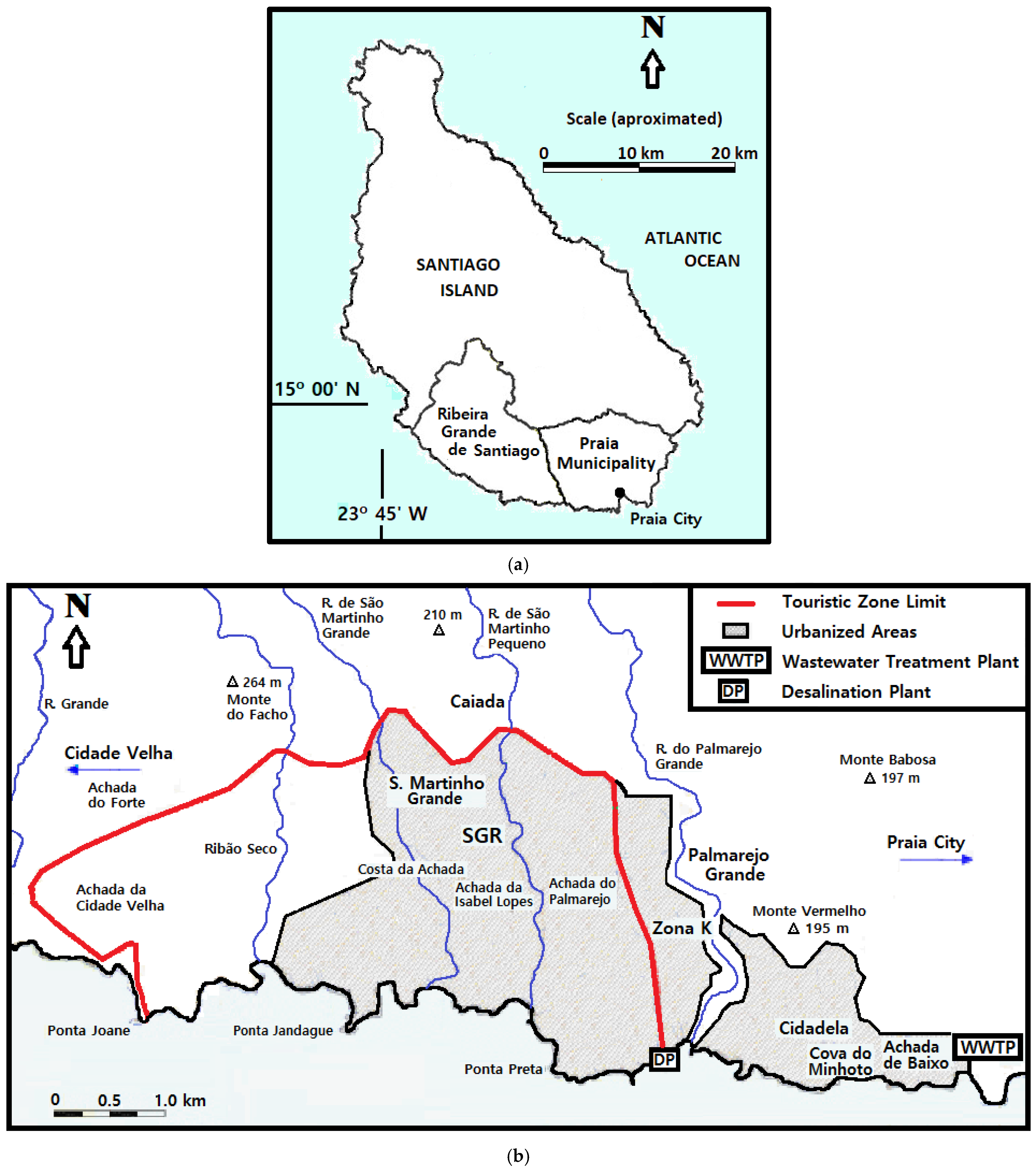
The region under study is located in the southwest part of the municipality of Praia and in the south part of the municipality of Ribeira Grande de Santiago, in the south of the island of Santiago, Cape Verde, and is represented in Figure 2.
Santiago Island and Cape Verde Archipelago are situated in the Atlantic Ocean about six hundred kilometers west of Dakar in Senegal on the African continental coast and have areas of 911 and 4033 km2 with populations of about 274,000 and 491,000 inhabitants in 2021, respectively [33]. Figure 2a that was drawn based on República de Cabo Verde (2005) [34], AMS (2008) [35], and INE (2022) [33] shows the geographic location of Santiago Island, of Praia City, and the current administrative delimitations of the two south-southwest municipalities of the Island. Praia is the capital of Cape Verde and the largest urban center of the country. Its municipality has an area of 112.4 km2 and a total population of about 145,000 inhabitants in 2021.
The study area (Figure 2b) includes a main set of large urbanizations and green spaces, designated by Santiago Golf Resort (SGR) or Estrela Santiago, with about 600 hectares, and three additional important urbanizations developed along the coastal region between the SGR and Praia City, designated by Zona K, Cidadela, and Palmarejo Baixo (also known as Tecnicil [24]), respectively. Figure 2b was drawn, like all the water infrastructures that are schematically represented in all the following figures of this paper, based on the developed projects and on the Cape Verde map at scale 1:25,000, Sheet n° 58, and edited by Serviço Cartográfico do Exército Português [36]. The urbanized areas have a total length of about 6 km along the coastline and up to 2 km in the inland direction. SGR is totally included in the Integral Touristic Development Zone (ZDTI) administratively defined for the region [37,38] and is expected to have about two tens of thousands of inhabitants at its maximum planned capacity. SGR was planned to be one of the main tourist developments in the country, with more than two thousand residential villas and apartments and several hotel facilities with an overall capacity of more than a thousand beds, several commercial and equipment areas, and several large green spaces, including two golf courses, occupying a total green area estimated from about 40 to 60 hectares. Additionally, the local villages of São Martinho Grande and Caiada, located inside the intervention area, would be requalified to serve an estimated total population reaching a maximum of 5500 inhabitants in the project horizon. Achada de Baixo urbanization has a total area of 15 hectares and was planned for 1000 inhabitants, Cidadela 113 hectares and 30,000 inhabitants, and Zona K was predicted for 10,000 inhabitants, predominantly in residential apartments.
Cape Verde Archipelago is volcanic in origin. Santiago Island orography generally increases inland and is characterized by a small mountain range in the longitudinal direction, comprising Serra da Malagueta farther north, with a maximum altitude of 1064 m, a small plateau in the central region, called plateau of Assomada or of Santa Catarina, and the massif of Pico da Antónia that resulted from the main eruptive process that includes the highest point of the island at 1394 m, near the North limit of Ribeira Grande de Santiago municipality. In the more coastal regions, the orography is characterized by the existence of very dug valleys, with the presence of important ravines resulting from accentuated hydric erosion, sometimes alternated by relatively flat surfaces or with small convexity locally called “Palmarejos”. In the study area, the topography is generally descending to the south, and there are several streams transporting practically only direct surface runoff, with steep slopes and deep valleys running perpendicularly to the coastline, where they discharge. The two main streams that cross SGR are Ribeira de S. Martinho Grande and Ribeira de S. Martinho Pequeno, which have average inclinations of 5.6 and 3.8%, respectively, and relatively long drain watersheds. Their drainage basins have areas of 26 and 7 km2 and average altitudes of 403.5 and 181 m, respectively.
The precipitation, especially in the coastal areas, has characteristics close to arid to semi-arid climates. At the lower altitudes, the average annual precipitation is currently between just about 100 and 200 mm per year. The precipitation is erratic, uneven over the years, and concentrated practically in just three to five months in the year. However, precipitated volumes rise considerably towards inland with the increase in altitude and reach average and median annual values a little above 600 mm locally in Serra da Malagueta. The slopes facing north and northeast are the wettest due to the north winds and trade winds that blow practically throughout the year in the southwesterly direction, with the air often presenting considerable relative humidity, especially in the areas of higher altitude. The south-southwest coastal regions are the driest [39]. Rainfalls in the wet season are frequently intense and of short duration, causing torrential runoff, with high peak flows and high flow velocities, erosion of banks and beds, and considerable solid transport and deposition of materials of different granular sizes downstream.

2.2. Requirements of the Systems

2.2.1. Water Supply Network

SGR is totally limited to the south by the coastline and to the east by the road that gives access to the Palmarejo Desalination Plant (see Figure 2). The topographic elevations of the area to be supplied with drinking water vary from values slightly higher than the average sea level in the coastal area to the west of Ribeira de S. Martinho Grande, to a maximum of 115 m, reached in the village of Caiada.
Due to the scarcity of superficial and underground fresh water resources, the desalinated sea water produced in the Palmarejo Plant is currently the main origin of the public water supply service to the Cape Verde capital and its municipality. According to Electra (2024) [20], it currently has a production capacity by reverse osmosis of 2000 m3/day and produced and distributed an average of about 14,700 m3/day in 2023. The origin of the water supply system to SGR is also desalinated sea water. This can be done by the existing Desalination Plant of Palmarejo managed by Electra, or eventually by a new desalination plant to be constructed by the Touristic Complex, more or less close to the existing plant.
The per capita consumption considered for the residential, commercial, and hotel areas and its evolution throughout the infrastructure’s useful life were established based on detailed local information and on consumption observed for similar cases. There are no expected agricultural consumption, important industries, or hospitals in the area of the studied urbanizations. For the project horizon of the civil construction works and for the maximum capacity of systems at full operation, the considered per capita fresh water consumptions are 50 L/employee/day in commercial areas, 150 L/inhabitant/day for the local populations, 220 L/inhabitant/day for the touristic residential areas, and 540 L/bed/day for hotels. The resulting maximum required capacity was calculated in values of the magnitude order of 3500 m3/day, which represents an extremely high value in view of the scarcity of fresh water resources on Santiago Island, in general, and particularly in the studied coastal area.

2.2.2. Wastewater Collection and Treatment System

The general interceptor installed approximately along the coastline in the west-to-east direction has a total length of several kilometers and is projected to serve an estimated maximum total population of about 61,000 inhabitants in the project horizon. It progressively collects along its path to the Praia WWTP, through several main trunk sewers, all the wastewater produced in SGR intervention areas and in the Zona K, Cidadela, and Palmarejo Baixo planned urbanizations. The ending part of the interceptor, with a length of more than 2 km, was previously constructed and the material is PVC of the class 0.4 MPa with 500 mm diameter. It was designed considering a constructive minimum pipe inclination of 0.5% along its path, a maximum relative flow depth of 50%, and a roughness coefficient in the Manning equation of 0.01 m−1/3 s. The design peak flows of the previously constructed 500 mm PVC interceptor vary between about 0.12 and 0.20 m3/s (Estudocivil, 2000 [40]).
The maximum average daily collected flows can be estimated at about 7700 m3/day in the project horizon year at full occupation, corresponding to an average per capita wastewater produced and an average per capita water consumption of about 130 and 180 L/inhabitant/day, respectively, considering an affluence factor of about 0.7. However, it should be observed that in arid to semiarid regions, the average wastewater flow reaching the wastewater network and the treatment plants can be significantly inferior than the fresh water introduced or consumed in the water distribution system, and the ratio between both, which is normally between 0.7 and 0.9, can be significantly reduced up to values of the order of 0.4, or even less. Additionally, the collected wastewater flows in the initial period of the system operation are very small due to the still small initial levels of urbanization and occupation, and thus it is expected that the average produced treated wastewater flows along the entire project horizon are significantly lower.
The Praia Wastewater Treatment Plant initially received only the wastewater volumes collected in the city, which were submitted only to primary treatment before their discharge into the sea [41]. The plant was remodeled in 2007 and comprises since then a pumping system at the entrance, a preliminary treatment with screening and grit chambers, primary sedimentation followed by biological treatment of activated sludge type, disinfection by ultraviolet and, subsequently, by chlorination, sludge thickening, recirculation circuits, sludge anaerobic digestion, polymer dosing, and sludge dewatering [42,43]. The wastewater collected in the new urbanizations and transported by the interceptor would be treated in the Praia WWPT, together with the city wastewater flows. The treatment plant design flow is about 8450 m3/day, and it was expected that the daily wastewater inflow would be a little above 8000 m3/day in 2007. However, due to important insufficiencies both in the water distribution system and mainly in the Praia wastewater network, with very limited house connections, the daily average inflows to the plant were kept at very low values of just about 1000 m3/day up to 2013. An important wastewater inflow increase occurred in 2014, and a daily inflow slightly below 3000 m3/day was already observed in 2017 (Electra, 2002 to 2018 [20]).

2.2.3. Irrigation System

Several preliminary studies were previously performed in order to determine the water requirements for several green spaces to be implemented in the arid area of the SGR Complex (Topiaris, Onno Shaap, 1998, Atelier Difusor de Arquitectura, 2001 [44,45,46]). Some of the main irrigation requirements considered in those studies are summarized in Table 1.
Due to the particularly difficult climatic local conditions, the implementation of consistent green spaces may require an average water consumption between about 5 and 7 L per day per m2 of irrigated area. An estimation performed by the authors for the water irrigation system requirements based on the above-mentioned studies, based on the areas and landscape crops to be irrigated inside the intervention domain of SGR and on other local information, gave average annual flow rates of the order of 3300 m3/day and maximum daily flow rates of about 4800 m3/day to be guaranteed during three months of the year, between March and May. These water requirements are mainly due to the irrigation of golf courses (a standard and an executive) that require an estimated average annual flow rate of about 3000 m3/day. For the remaining urbanizations, the water requirements are estimated at 10% of the total, resulting in average and maximum water daily volumes of about 3650 and 5300 m3/day, respectively.

2.3. Previous Studies and Performed Analysis

The SGR intervention area to be served by the water supply system is relatively large. It has a great amplitude of elevations, in the order of more than one hundred meters, which requires the consideration of several pressure levels, and includes several rugged zones, which hampers the water supply system conception, as well as its suitable management and operation. Previous preliminary works recognized generically the existence of three pressure levels, and a reservoir was designed (Estudocivil, 2000 e 2001 [47,48]). However, the mode of feeding this reservoir and the general conception of the water supply system to SGR, as well as the supply of the three identified subsystems with different pressure levels, were left open.
Based on these and other subsequent studies [49,50], and mainly on the new urbanization plans meanwhile developed [51,52] and on an extensive set of local information, particularly from the entity responsible for the existing systems management, the following essential aspects were identified in the present research work: the required potable water total volumes, the possible alternative water sources, the general layout of already existing infrastructures, and various feasible solutions for the intended water supply in the SGR intervention area. The basic issues studied are the identification, definition, and mode of supplying the pressure subsystems for the whole area to be served, as well as the interconnection between the subsystems and the water source, in order to maintain the investment and operation costs as low as possible, satisfying the requirements for quality performance according to the official regulations.
The identification and the establishment of the altimetric levels of distribution, in particular, were thoroughly analyzed based on the topographic characteristics of the SGR intervention area, the spatial distribution and typology of the land occupation, according to the urbanization plans, and considering the minimum pressures to be guaranteed in the various water devices of the existing or projected different buildings and the maximum pressures to be met at any point of use. In the general conception of the water supply system, a particular emphasis is given to the selection of the number of reservoirs and to its location, weighting the proximity of the places of consumption and the required water flows and service pressures, the distance to the supply water origin, the best layout for the pumping main and for the main distribution pipelines, the capacities and elevations of the reservoirs, and the pumping systems requirements in order to minimize the construction and operation costs.
The preliminary solution for the wastewater interceptor system that was initially projected and, after some adaptations, partially constructed downstream of Ribeira do Palmarejo Grande considered a long interceptor approximately parallel to the coastline that conveys the collected flows from the planned urbanizations to the Praia Wastewater Treatment Plant. The interceptor transversely crosses several small drainage basins and very deep valleys, which poses several difficulties to its conception and design, particularly in open channel flow. The collected wastewater, jointly with the wastewater drained by the sanitary sewer system of the city of Praia, is submitted to a tertiary treatment in the Praia WWTP and is then reused for landscape irrigation of several planned green spaces in the area of the urbanizations after being transported in pipe flow in the reverse direction by a pipe under pressure.
Due to the enormous topographic difficulties along the sewer interceptor, with the requirement for the crossing of several deep valleys with layouts approximately perpendicular to the coastline, several pumping systems and several relevant special structures composed of aerial crossings performed by dedicated bridges were initially proposed (Estudocivil, 2000 [40]). However, only part of the interceptor, totally buried and totally governed by gravity, downstream of the valley of Ribeira do Palmarejo Grande, was previously constructed. This was achieved with a considerable increase in the upstream sewer invert elevation in the vicinity of this valley in order to eliminate the sole significative aerial crossing initially predicted between Ribeira do Palmarejo Grande and the Praia WWTP. In this zone, a small portion of the interceptor in Cova do Minhoto that was initially projected as an aerial crossing consisting of a dedicated bridge was also not constructed.
Several different feasible solutions were studied in this research work for the interceptor system layout upstream of Ribeira do Palmarejo Grande in order to include in the decision process not only all the restrictions of the problem but also all the urbanistic and environmental elements considered relevant in the decision-making. In the absence of available host bridges for the crossings, the possible analyzed solutions include dedicated bridges for aerial crossings in open channel flow, eventually executed as bridge–channel structures, inverted syphons, and pumping systems. The interrelation of the plan layouts and invert elevations of the gravity sewer interceptor and of the main trunk sewers with each corresponding alternative solution for each special structure is analyzed in detail in order to guarantee gravity drainage along the urbanizations and the hydraulic continuity at the confluence or junction nodes, minimizing both the construction and operation costs.
With respect to the recycled water system, part of a pumping main with about 1 km in length was previously constructed between the Praia WWTP and Cova do Minhoto. The irrigation system initially conceived to serve the green spaces of the SGR urbanizations (located to the west of Ribeira do Palmarejo Grande) included a main pipe upstream, governed by gravity, that was fed by a small reservoir to be built at a high zone near Cidadela and that would receive the treated water flows pumped from the WWTP [53,54]. It was assumed that the irrigation service for the different urbanizations of the whole area could be performed with the installation of pressurization equipment.
A preliminary study previously performed by Onno Shaap (1998) [45] for the irrigation of a golf course installed in a smaller initial total area of about 41.5 ha inside SGR, based on the FAO Computer Program CROPWAT 7 [55], assumed a constant daily average water flow rate transported by the recycled water pipeline under pressure equal to the gross average requirements for irrigation that was estimated at about 2056 m3/day. This program calculates a potential evapotranspiration of reference based on the Penman–Monteith method and an effective precipitation based on the USDA Soil Conservation method. The climatological data used were relative to the Praia meteorological station for the period of 20 years between 1941 and 1960. That study obtained an average annual potential evapotranspiration of reference of 1869 mm/year, or 5.1 mm/day, against average total and effective precipitations of 260 and 232 mm, respectively. Even if the considered period is relatively favorable in terms of average annual precipitation, the calculated monthly potential evapotranspiration is always above the monthly effective precipitation, showing a permanent monthly hydric deficit. This preliminary study proposed a flow regularization technical lake with about 130,000 m3 capacity due to the predicted strong variation of the irrigation water requirements throughout the year. Due to the very small treated daily wastewater flows produced in the Praia WWTP, particularly at that time, the allocation or mobilization of other conventional fresh water sources was already strongly predicted to be required, and possible solutions of both underground and superficial water sources were preliminarily investigated (Osório, Silva e Sabino, 2007a, 2007b [56,57,58]).
Besides the complexity of the interceptor system conception and construction, several important drawbacks to be overcome were recognized, namely the following: (i) the long distance between the SGR urbanizations and the Praia WWTP; (ii) the requirement for pipes under pressure, governed by gravity or forced, without natural ventilation, associated with the warm temperatures of the region; (iii) the small produced treated wastewater flows; and (iv) the absence of sustainable alternative fresh water sources for irrigation with available water volumes at acceptable costs, to complement the irrigation needs. Additionally, given that the treated wastewater would be stored in a superficial lake that can be classified as a sensitive water body inside the urbanized perimeter, the necessary final effluent quality, particularly in terms of total suspended solids, residual organic pollution, and nutrients [59,60], according to the local experience, can also become a major concern. Under the well-known concept of small is beautiful, the consideration of one (or even more) new WWTPs to be constructed closer to the SGR urbanizations was also weighted. However, the autonomy that it could provide does not seem to compensate, at least in the medium term, for the very low wastewater inflows predicted for the initial stages of the urbanizations and the loss of economies of scale and local integration. Nevertheless, at least at this stage, no exhaustive life cycle, cost–benefit analysis, or mathematical programming model has been developed for optimally comparing centralized and decentralized wastewater systems according to all the different areas served by the wastewater networks, the level or levels of treatment required for eventual different uses, and the quality and quantity of the required reclaimed water and their points of delivery.
The relevance and dimension of the water resources management and urban hydraulics problems in the region under study, the economy of resources, environmental sustainability, and the synergy of efforts of the several intervenient in this international project were the engine that allowed the development of the research work that is presented in this paper.

3. Results and Discussion

3.1. Water Supply System

The performed analysis and the general development of the water supply system to the SGR Complex integrate three fundamental vectors: (i) the water sources and its reliability in terms of quantity, quality, and continuity; (ii) the water transport up to the main system regularization reservoirs; and (iii) the conception of the system of reservoirs and water distribution network, minimizing the overall construction and operation costs, including energy.
As pointed out before, the available superficial and underground water resources are very scarce in Santiago, particularly in the south-southwest where Praia and Ribeira de Santiago municipalities are located, given that it is the driest part of the island. Also, the precipitation and water resources vary considerably throughout the year and may vary considerably between consecutive years or consecutive periods of years, introducing additional vulnerabilities that are sometimes difficult to overcome. Under these circumstances, the main water source currently used for the fresh water public supply to the Praia municipality is desalination by reverse osmosis of sea water. The salty water is captured in deep wells near the sea border, and the treatment is performed in the Palmarejo desalination plant located in the southeast adjacency of the SGR Complex (see Figure 2). The source of the SGR water supply system is also desalinated water from the Palmarejo desalination plant, at least in the first stage of the urbanizations, or eventually, in further stages, from a new desalination plant constructed more or less near the existing one.
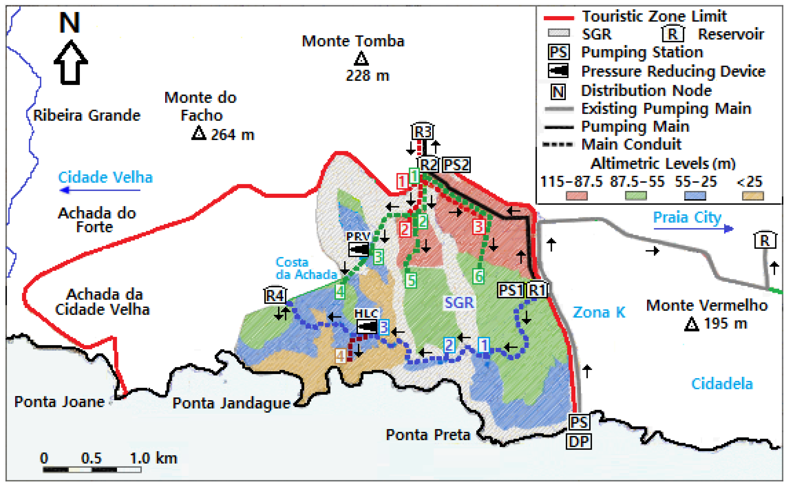
The devised general solution for the supply system is schematically represented in Figure 3, where it is possible to identify four pressure altimetric levels to be served by the water supply network. The four altimetric levels were identified and established according to the land occupation considered in the urbanization plans. The lower altimetric level below 25 m requires smaller water volumes, given that, besides some hotels in the coastal border, it serves just a limited number of urbanizations in the west part of the Complex. The adopted solution consists basically of a sequential system of three regularization reservoirs (Reservoirs R1, R2, and R3 of Figure 3) with a total capacity of about 5000 m3. The three reservoirs that generically serve the four pressure levels are fed by three successive pumping systems with the corresponding pumping mains. The first feed pipe originates in a pumping station located in the Palmarejo desalination plant, or eventually, in further stages, in a new desalination plant relatively near the existing one.
The location of the first regularization reservoir, R1, has in particular consideration the source of the water supply system and the possible use of existing infrastructures on one hand, and the interconnection with all the remaining reservoirs, the proximity to the gravity center of the consumption areas, and the required pressures on the other hand. The area to be directly served gravitically by R1, which is located below the ground elevation of 55 m, is relatively long, with dispersed consumptions, and their urbanizations may have a possible significative increase along the project horizon, particularly in the west part of SGR and in the lower part of the golf courses (southeast part of SGR). Therefore, the adopted solution additionally considers the possibility of the construction of a small equilibrium reservoir, R4, with about 500 m3 capacity, located in the higher zone of Costa da Achada, for equilibrium of pressures in the altimetric level between the elevations of 25 and 55 m of the SGR western region in order to approximate the supply by gravity to the corresponding areas of consumption that are at this altimetric level.
The four reservoirs, R1, R2, R3, and R4, are installed approximately at the ground elevation (semi-buried), with base elevations of about 82, 111, 135, and 77.5 m, respectively. The selection of the number, location, capacity, and base elevation of the four reservoirs had in consideration, besides the existing infrastructures, the relatively small consumption below the elevation of 25 m, the proximity to the center of gravity of the consumption locations, the pressures to be guaranteed in the corresponding served areas, and the largest possible number of people and consumptions to be served by the reservoirs located at the lower elevations. The main purpose of the adopted strategy was to try, this way, to avoid unnecessary energy waste and to limit, as much as possible, the use of pressure reduction devices, as well as to constrain the proliferation of the number of reservoirs and required pumping systems. Beyond relevant energy savings, potential problems of pressure reduction devices, such as deficient functioning and issues related to the requirements for regular inspection and maintenance of this equipment, are thus minimized, increasing the resilience of the water supply system. However, due to the multiple topographic difficulties of the served area and large amplitude of the terrain elevations, two pressure reduction devices could not be avoided, respectively, at the entrance of the altimetric level below 25 m in the oceanic zone (west of Achada da Isabel Lopes) served gravitically by R1, where a head loss chamber (HLC) is assumed, and at the lower part of S. Martinho Grande village, which is served gravitically by R2, where the installation of a pressure reducing valve (PRV) is considered.
There are several alternatives to feed the first SGR supply system reservoir, R1, along the project horizon. The water supply system of Praia includes a pumping main pipeline with origin in a pumping station located near the Palmarejo desalination plant that feeds a main reservoir, R, located in Monte Babosa (see Figure 3). Although several performance problems were generically identified by the supply system manager, it was advanced that in a preliminary phase of the urbanizations, this subsystem could eventually be temporarily shared for the R1 supply, at least after some improvements and relevant adjustments. In further stages, however, with the development of the urbanizations, even if the general layout may be generically maintained for the water supply of R1, new pumping mains, a new pumping station, or even a new desalination plant may be eventually constructed. In the case of a new desalination plant, it could be used not only for the potable water supply of the Complex but also for the irrigation of priority SGR green spaces, particularly in emergency situations, increasing the dependability and resilience of the water infrastructures and of the overall urbanization plans.

3.2. Sewer Interceptor System

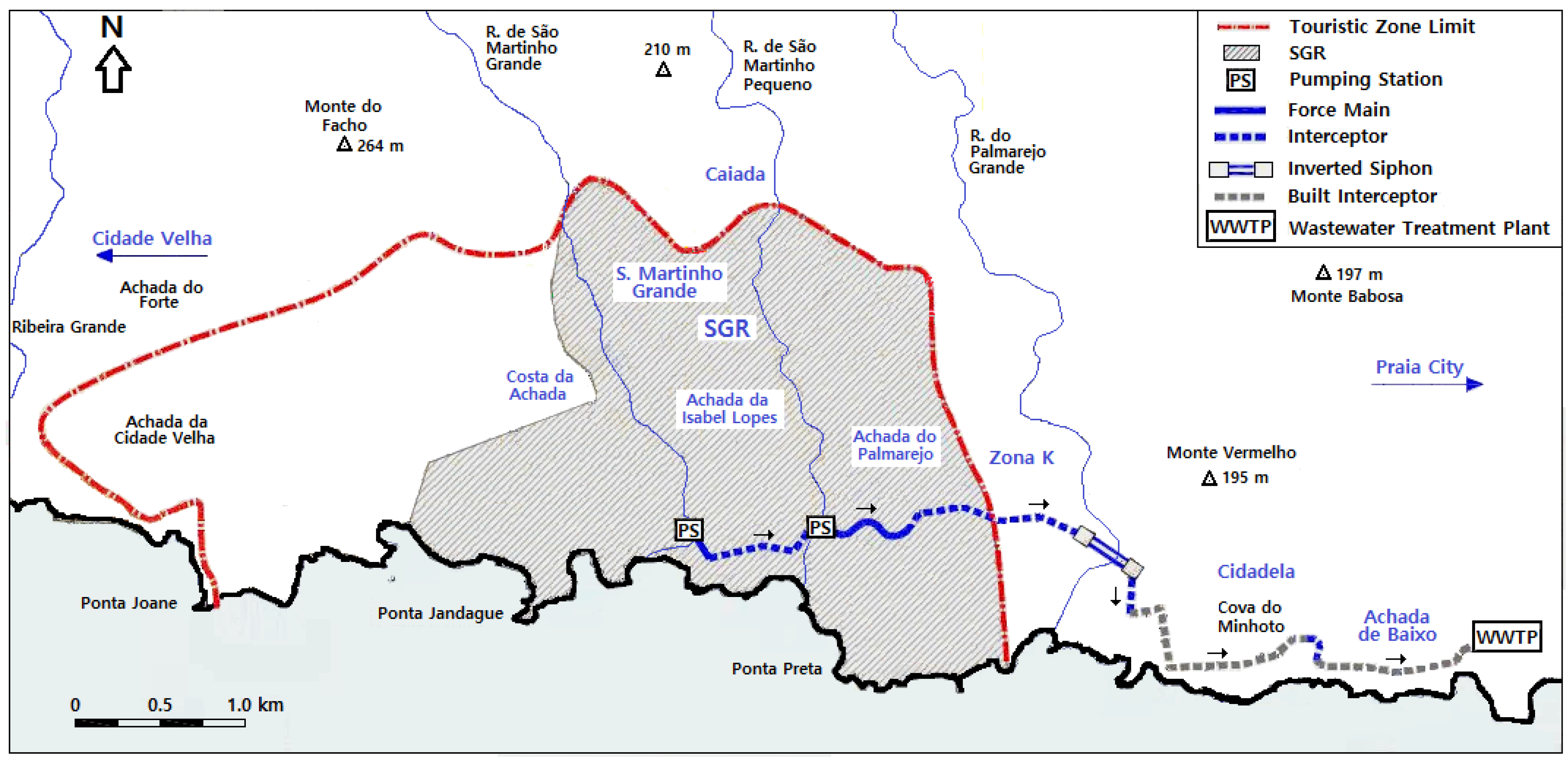
Several different possible solutions for the layout and profile of the sanitary interceptor system upstream of Ribeira do Palmarejo Grande were analyzed in order to include in the decision process not only all the technical constraints of the problem but also all the urbanistic, topographic, and environmental elements considered relevant. Due to the inexistence of host bridges for aerial crossings, the possible solutions resided between dedicated bridges, eventually by bridge–channel structures, inverted siphons, and pumping systems. The adopted generic solution for the interceptor system is represented schematically in Figure 4. It allows the full drainage by gravity of an important parcel of the area to be served and to eliminate several aerial crossings initially conjectured, some of which with extremely significative length and wingspan.
The solution had in consideration an important set of conditioning factors, namely: (i) the high invert elevations that are required downstream to allow the connection to the interceptor that is already built; (ii) the crossing of a deep valley in the proximity of the wells used as the salty water sources of the Palmarejo desalination plant for posterior water public supply; (iii) the impossibility of installing the sewer conduits in the coastal zone due to the golf fields planned for that zone; and (iv) the frequent topographic difficulties of the drained areas and of the zones crossed by the interceptor.
The adopted interceptor moves away from the coastline in the approximation and passage of Achada do Palmarejo due to urbanistic and environmental constraints and for technical and economic reasons, particularly to guarantee the hydraulic flow continuity by gravity in the arrival at Cidadela. It includes two pumping systems as main elements in the regions of the valleys of the streams of S. Martinho Grande and S. Martinho Pequeno and an inverted siphon for the crossing of Ribeira do Palmarejo Grande, interconnected by descending circular conduits in open channel flow, linking downstream to the 500 mm diameter interceptor previously built. The topography and invert elevations of the built interceptor allow the Cova do Minhoto crossing to be performed through a buried conduit that is externally protected by concrete, working in open channel flow.
The inverted siphon design, in particular, was performed by considering the extremely adverse topographic conditions of the crossed valley, the considerable length of the crossing, the predictably high maximum flow rates and expected high flow variation both during the day and along the project horizon, the high temperatures of the region, and the aggravation of the downstream connection circumstances. The siphon has two equal barrels in parallel working alternatively, in order to allow, in particular, routine cleaning and maintenance operations; it uses an available hydraulic gradient that is relatively high and is submitted to compressed air injection in steady flow in the base of the rising branch in order to allow the airing of the liquid mass [61,62,63] and to guarantee an additional wastewater elevation and solids transport increase due to the well-known air-lift effect [64,65]. A rigorous maintenance and monitoring protocol is foreseen for the two-barrel large-diameter inverted siphon working under steady air-lift conditions, with siphon inspections performed at regular intervals.
Additionally, mechanical screening bars are suggested in the siphon inlet chamber for removing grosser materials transported in the wastewater, and also the construction of a reservoir for which the wastewater can be temporarily removed. The steady-flow air injection at the base of the rising branch may be essential, in particular in the first years of operation, due to the high temperatures of the tropical climate and the requirement to maintain aerobic conditions and hydrogen sulfide formation at acceptable levels. A first approximation that may be proposed for this period considers a steady air flow rate not less than the wastewater average flow rate for an estimated relative piezometric head of the single-phase flux of about 40 to 50 m.
It is likely that, due to urbanistic conditions and the golf courses’ design, a drainage fully by gravity of the lower golf urbanizations in the southeast part of the Complex to the pumping station located in Ribeira de S. Martinho Pequeno Valley will not be possible. In this case, the problem’s solution can be the installation of a small pumping system with pneumatic injectors at an elevation of about 25 m (in the center of these urbanizations located relatively near the coast), with a small force main that discharges the wastewater in a planned street at an elevation of about 50 m, and its subsequent transport by gravity to the mentioned main pumping station, together with the effluents drained on that street. The adopted location for the pumping station of Ribeira de S. Martinho Pequeno valley will allow for the collection by gravity, as much as possible, of all the wastewater drained in a wide central region of the Complex; this may also be a preferential potential location for a future eventual wastewater treatment plant, as an alternative to the transport of the wastewaters collected in the Complex to the Praia wastewater treatment plant.

3.3. Recycled Water Pipeline

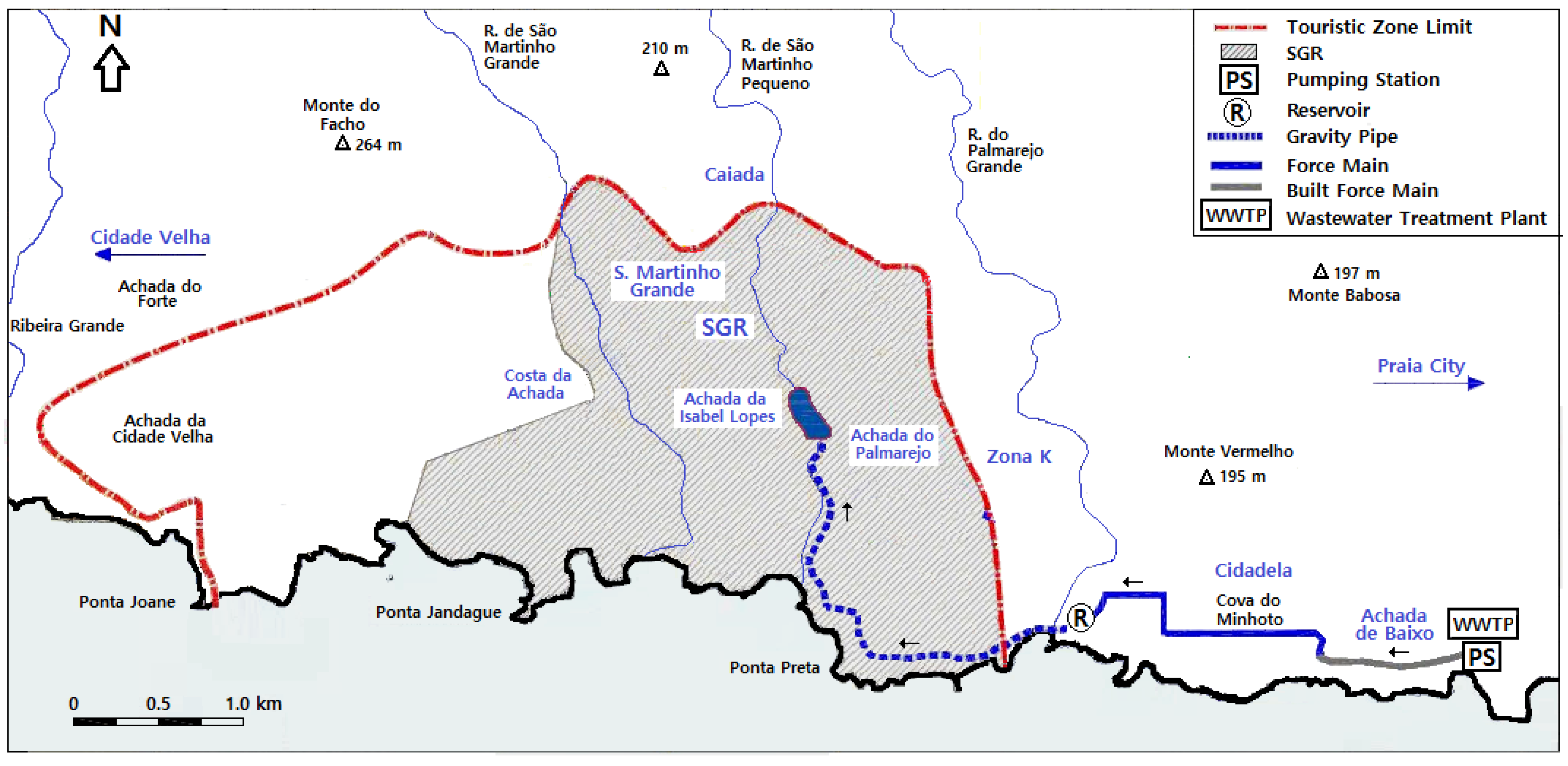
The devised system of treated wastewater for landscape irrigation of green spaces is represented in Figure 5. The system includes a pumping main partially existing between a pumping station located at the Praia WWTP exit and a small distribution reservoir near the east slope of Ribeira do Palmarejo Grande, in Cidadela, at an elevation of an order of about 50 m, and a conduit fully governed by gravity connecting this reservoir downstream to an important reservoir or artificial lake at Ribeira de S. Martinho Pequeno valley in a zone near the golf courses. The first part of the pumping main, with about one kilometer up to Cova do Minhoto, was previously built (see Figure 5). The first approximation for the generic location of the golf irrigation lake inside SGR, which is shown in the figure, was proposed by Faldo Design (2007) [66].
In order to minimize the environmental risks of the discharge and the reuse of tertiary treated effluents in the urban lake, a typical regular quality control with respect to residual organic load and nutrients, particularly nitrogen and phosphorus, should be performed. Given that the advanced treatment at the Praia WWTP includes disinfection, the risk of microbial contamination and potential pathogen contact through the lake water seems unlikely under normal operation conditions [67]. Nevertheless, there are emerging contaminants, such as microplastics or pharmaceuticals, that are known to not be removed in conventional treatment plants and that need to be subject to rigorous assessment [68], particularly with respect to their implications in waterborne diseases and public health in the medium to long term.
Although the treated wastewater average flow rates produced by the Praia WWTP at the beginning of the project horizon are relatively small and are insufficient for the full irrigation of the whole planned green spaces of the urbanizations, the conduits were designed for the maximum daily flow rate according to the full irrigation requirements. It was assumed that such treated wastewater average flow rates can be produced in the later stages of the project horizon with the natural improvement of the municipal water supply system and the municipal sanitary sewer network, and with the development of the urbanizations. However, due to the insufficient available treated wastewater average volumes, particularly in the first years of operation, and also to the strong variation of the irrigation requirements throughout the year, which are expected to diverge considerably from the variation in recycled water production, it seems indispensable to consider not only other complementary water sources or even alternatives, particularly in the case of any temporary interruption of production, but also anticipate an important storage capacity.
The lower zones of the golf courses, below about 30 m elevation, will be irrigated preferably by gravity directly from the distribution reservoir of Cidadela, working the irrigation lake, in this case, as a downstream extremity reservoir. Due to their expected lower water requirements, the irrigation systems of Palmarejo Baixo and Cidadela urbanizations can be directly served by connections introduced in the pumping main or, preferably, from the small Cidadela distribution reservoir.
The pumping main plan layout, several kilometers long, has a profile with several high and low intermediate points. However, the pipe is always below the hydraulic grade line (relative piezometric grade line), even if it is close to it in some extension in the region of Cidadela. Although variable speed pumps could be used in the pumping station located at the WWTP exit, it may be largely preferable to build a storage reservoir in the plant for storing the treated wastewater produced volumes to be pumped due to their probable large variation along the project horizon. The system’s general reliability and resilience is improved, and the pumping equipment with constant speed pumps can work in a more constant mode, increasing the pumping efficiency and reducing the inconvenience that can eventually occur in a long pumping main with an irregular profile due to the water hammer.

3.4. Complementary Irrigation Sources and Long-Term Governance

The developed study indicates that the treated wastewater pipeline should be connected with a storage lake or, eventually, with a system of artificial lakes to be built in the region of the urbanizations. Under the probable contingencies of recycled water production in quantity and acceptable quality patterns for a sensitive water body, like a superficial lake, and particularly in the case of an emergency, the mobilization of other complementary or alternative water sources from superficial or underground origin, or even resulting from desalination, may be required.
With respect to the superficial fresh water mobilization that may be potentially considered, Table 2 presents the geometric characteristics of the basins and the average slope of the main streams that cross or are adjacent to the SGR urbanizations served by the infrastructures treated in this paper. The two main streams that cross the region of the urbanizations, with total lengths of 17.9 km and 8.8 km and average slopes of 5.6 and 3.8%, are, respectively, Ribeira de S. Martinho Grande and Ribeira de S. Martinho Pequeno; their drainage basins have areas of 26 km2 and 7 km2 and the highest points are at elevations of 1055 m and 355 m, respectively. The two basins are very elongated, with Gravelius coefficients of 1.92 and form factors below 0.1.
Table 3 shows the elevations and the mean and median annual precipitations for the period of 46 years between 1961 and 2006 in six rain gauge stations located in the south-southwest region of Santiago Island, according to the data presented in Diogo et al. (2021) [39]. A correlation is established in this work between the observed precipitations and the corresponding elevations of the six rain gauge stations, assuming a linear variation. The results are presented in Table 4 and show coefficients of determination, R2, of about 99%. It is thus absolutely clear that the average and median annual precipitation directly increase with altitude in this region. However, it is likely that this excellent result and the extremely high obtained coefficients of determination could slightly decrease with an increasing number of considered stations.
Table 5 presents the average elevations of Ribeira de São Martinho Pequeno and Ribeira de São Martinho Grande basins, and also the mean and median annual precipitation computed for these elevations, according to the equation and coefficients a and b presented in Table 4. According to this estimate, these annual precipitations are around 200 mm and 300 mm for the average elevations of the basins of S. Martinho Pequeno (181 m) and S. Martinho Grande (403.5 m), respectively.
The most promising solution seems to point to the possible utilization of Ribeira de S. Martinho Grande superficial waters, given its much larger basin area and much higher potential of precipitation due to the higher average altitude. This could be done with a dam construction in that stream or with the transference of its waters to the S. Martinho Pequeno Lake or to another artificial lake to be constructed in a suitable zone relatively close to the irrigated areas of the Complex.
A first approximation based on the necessary maximum daily flow rates estimated for landscape irrigation of about 4800 m3/day to be guaranteed in the driest period of the year between March and May, as mentioned in Section 2.2.3., and assuming as the worst-case scenario a complete interruption of the recycled water supply during two to three of these months, points to a required total reserve capacity for the storage artificial lake or system of lakes in the order of 300,000 to a little above 400,000 m3. Beyond the generic potential location of the artificial lakes and of the estimation for the required volumes, the specific design of the lakes was not performed. However, an estimate for the average depths of the ponds between about 5 to 10 m and 25 to 30 m may be advanced. For these depths, the water losses by direct evaporation from the water surface, while relevant due to the unfavorable local conditions and already included in these volumes, may be considered relatively residual. It seems important to develop further studies to determine the exact storage volume required for the artificial lake or system of lakes, their exact best location according to the local orography, and the best solution for the complementary water sources and the corresponding water volumes to be allocated or produced along the project horizon.
Besides Ribeira de S. Martinho Grande and Ribeira de S. Martinho Pequeno superficial waters, the analysis should include the drilling of wells for the mobilization of potential underground aquifers and the direct use of desalinated water, particularly in the case of an emergency, due to their still-high unit production costs. With respect to the underground water, due to the high volumes required, the characteristics of the hydrogeological formations of Santiago Island, and the probable difficulty of the aquifers recharge, it should be considered only in emergency situations or for duly controlled limited periods of time, given that the aquifers’ overexploitation may introduce serious and irreversible risks of saline intrusion. According to Electra’s past experience mentioned in their annual reports [20], it is possible to observe a progressive reduction in the underground water production. This seems to basically result from the limited recharge capacity of the aquifers due to the low local precipitation, and also because it is likely that most of the aquifers are predominantly confined in small spaces. With respect to any potential saline intrusion, according to ANAS, there is a control system of the water temperature and conductivity of the groundwater abstractions in Santiago Island that shows that for most of the boreholes, the conductivity is below 2.000 μS/cm [71,72].
The eventual construction of a new desalination plant for the Complex water supply network, and in particular the use of renewable energies, may allow an eventual reduction in the production costs, which can be a relevant step towards the potential use of desalinated water in irrigation. Also, the irrigation water can have a salinity slightly superior to the salinity of the potable water for human consumption, additionally reducing the potential production unit costs, even if the salinity of the wastewater observed at the Praia WWPT is tendentially already relatively high. The admissible amount of salt needs to be compatible with the soil and vegetation tolerance, taking into consideration the frequency of use and the medium to long term consequences. In a recent study performed for a Touristic Complex located on the southwest coast of Santiago Island, the total annualized unit cost of desalinated water for a production by reverse osmosis for a linear variation between 392 m3/day and 1442 m3/day for water supply along a project horizon of 50 years and a constant production of 2425 m3/day of irrigation water in the same period was estimated at 0.869 Euros/day [39]. For this computation, the capital costs required for the construction of a desalination plant and the subsequent operation, maintenance, and energy costs were considered. Although this unit cost seems promising and possible due to the technological advances in this area, the study has shown that irrigation with desalinated water is still systematically among the costliest solutions among several other available alternative sources.
One of the main challenges of urban water infrastructures is to guarantee a qualified operation and management of the systems. Suitable infrastructure maintenance, routine inspections, and laboratory analysis at programmed regular intervals are fundamental. Mechanical equipment and complementary installations, like pumping stations and special structures, require particular attention, particularly in the case of wastewater systems. The good performance of the infrastructures is directly related to environmental sustainability and public health. In this regard, integrated systems are advantageous in terms of enabling centralized management, also allowing for better long-term governance.

4. Conclusions

The consideration of large integrated water supply systems and sanitary sewer networks with wastewater treatment and reuse, particularly in regions with scarce water resources, may allow relevant economies of scale as well as better management of the systems and control of environmental performance. However, large systems often significantly increase the design difficulties and create multiple additional problems and challenges. The reuse of wastewater, in particular, allows synergy between indispensable wastewater treatment in order to minimize the environmental pollution footprint and the sustainable usage of the natural resource according to the different needs of the communities. It may be a significant step forward in the direction of the circular economy and environmental sustainability.
The collection, treatment, and reuse of wastewater at a regional scale for the irrigation of large green areas requiring large volumes of fresh water may be particularly relevant in tropical arid or semiarid regions, where both the availability and possibility of mobilization of superficial and underground fresh water resources can be very limited. However, in these regions, the produced volumes of treated wastewater may be significantly lower than the water volumes introduced in the water supply systems. This is due to the losses occurring both in the water supply networks and in the sanitary sewer systems, and also to the smaller wastewater volumes introduced into the sewers in the supply water usage compared to those that normally occur in cold or temperate climates. On the other hand, the quality requirements of the effluents after the treatment may be a concern, particularly in large wastewater systems in development under warm climates, with a great flow variation at the WWTP entrance, and when the predominant source of the supply network is desalinated water.
In large water supply networks and in regional wastewater systems, the design challenges and the topographic difficulties frequently increase due to the consideration of wider served areas. In big water infrastructures, it becomes essential to minimize the construction costs and the energy wastes, as well as to assure good operational conditions. In the water distribution networks, it may be fundamental to consider several altimetric levels to be served, according to the required service pressures, and also to minimize the usage of pressure reduction devices after the supply water has been pumped to the higher levels in order to guarantee minimum pressures to the end consumers. The water supply system presented in this paper, serving a relatively rough and wide area of about 600 ha, and with altitudes from a little above the sea water mean level up to about 115 m, was designed considering four altimetric distribution levels. The distribution network is supplied by three main reservoirs in series, interconnected to each other by pumping mains of successive pumping systems and by a fourth distribution reservoir for pressure equilibrium in one of the intermediate levels.
In large wastewater systems, it is fundamental to avoid or control potential septic conditions and to minimize the pumping systems, the pumped flows, and the length of pipes without natural aeration. This should be done by maximizing, as much as possible, the open channel flow extension in the buried pipes governed by gravity, according to the available topographic conditions. However, special measures for sulfide control are normally required, particularly in hot climates and when the consideration of conduits working in pipe flow becomes practically inevitable. The sanitary interceptor system presented herein transversally crosses several small drainage basins and several streams with deep and rugged valleys. It includes two main pumping systems and a large-diameter inverted siphon with the introduction of artificial aeration in steady flow at the base of the rising leg, allowing for sulfide control and improving the siphon hydraulics performance and the solids transport.

5. Recommendations for Future Studies

In the present case study, it was assumed that the main water source of the water supply system is desalinated water and that other complementary or alternative sources besides the treated wastewater produced in the Praia WWTP are likely required for the irrigation of the planned green spaces of the urbanizations. Further studies are considered necessary to optimally select suitable water sources according to the different needs in terms of quantity and quality, and according to the available superficial or underground water resources of the region that are possible to mobilize. Besides the investment and operation costs, resilience of the systems and environmental sustainability are two fundamental keywords in this context.
All the designs proposed herein thoroughly respected the applicable regulation requirements. However, most of the considered parameters and input data were based on typical values used in similar situations and on characteristic local data, and not in specific statistical treatment. Statistical analysis of relevant input data, mathematical programming, and sensitivity analysis, in particular, were not developed and can be included in further studies. The use of renewable energies, such as wind and solar energy, and particularly energetic efficiency, can also be developed in more detail in further studies.

Author Contributions

Conceptualization, A.F.D. and A.L.O.; methodology, A.F.D.; validation, A.F.D. and A.L.O.; formal analysis, A.F.D.; investigation, A.F.D. and A.L.O.; resources, A.L.O.; data curation, A.F.D. and A.L.O.; writing—original draft preparation, review and editing, A.F.D.; visualization, A.L.O.; project administration, A.F.D. and A.L.O. All authors have read and agreed to the published version of the manuscript.

Funding

This research received no external funding.

Data Availability Statement

The original contributions presented in this study are included in the article. Further inquiries can be directed to the corresponding author.

Conflicts of Interest

There are no conflicts of interest that have influenced the scientific contents presented in this paper.

References

  1. Meran, G.; Siehlow, M.; von Hirschhausen, C. The Economics of Water; Springer Water; Springer: Cham, Switzerland, 2021. [Google Scholar] [CrossRef]
  2. Tchórzewska-Cieślak, B.; Pietrucha-Urbanik, K.; Piegdoń, I. The Failure Risk Analysis of the Water Supply Network. Water 2023, 15, 3815. [Google Scholar] [CrossRef]
  3. Zimoch, I.; Bartkiewicz, E.; Machnik-Slomka, J.; Klosok-Bazan, I.; Rak, A.; Rusek, S. Sustainable Water Supply Systems Management for Energy Efficiency: A Case Study. Energies 2021, 14, 5101. [Google Scholar] [CrossRef]
  4. Silva, J.A. Wastewater Treatment and Reuse for Sustainable Water Resources Management: A Systematic Literature Review. Sustainability 2023, 15, 10940. [Google Scholar] [CrossRef]
  5. Sampaio, V.; Santos, A.S.P.; Lima, M. Decision support tools for water reuse: A systematic review. Water Sci. Technol. 2024, 90, 2713–2733. [Google Scholar] [CrossRef] [PubMed]
  6. Abdelkareem, M.; Mansour, A.M.; Akawy, A. Securing water for arid regions: Rainwater harvesting and sustainable groundwater management using remote sensing and GIS techniques. Remote Sens. Appl. Soc. Environ. 2024, 36, 101300. [Google Scholar] [CrossRef]
  7. Roldán-Cañas, J.; Moreno-Pérez, M.F. Water and Irrigation Management in Arid and Semiarid Zones. Water 2021, 13, 2446. [Google Scholar] [CrossRef]
  8. Gamboa, G.; Palenzuela, P.; Ktori, R.; Alarcón-Padilla, D.C.; Zaragoza, G.; Fayad, S.; Xevgenos, D.; Parada, M.P. Thermal seawater desalination for irrigation purposes in a water-stressed region: Emerging value tensions in full-scale implementation. Desalination 2025, 593, 118213. [Google Scholar] [CrossRef]
  9. Ragab, R.; Prudhomme, C. SW—Soil and Water: Climate Change and Water Resources Management in Arid and Semi-arid Regions: Prospective and Challenges for the 21st Century. Biosyst. Eng. 2002, 81, 3–34. [Google Scholar] [CrossRef]
  10. Pingale, S.M.; Jat, M.K.; Khare, D. Integrated urban water management modelling under climate change scenarios. Resour. Conserv. Recycl. 2014, 83, 176–189. [Google Scholar] [CrossRef]
  11. Nanekely, M.; Scholz, M.; Al-Faraj, F. Strategic Framework for Sustainable Management of Drainage Systems in Semi-Arid Cities: An Iraqi Case Study. Water 2016, 8, 406. [Google Scholar] [CrossRef]
  12. Alsaeed, B.S.; Hunt, D.V.L.; Sharifi, S. A Sustainable Water Resources Management Assessment Framework (SWRM-AF) for Arid and Semi-Arid Regions—Part 1: Developing the Conceptual Framework. Sustainability 2024, 16, 2634. [Google Scholar] [CrossRef]
  13. Hu, X.-J.; Xiong, Y.-C.; Li, Y.-J.; Wang, J.-X.; Li, F.-M.; Wang, H.-Y.; Li, L.-L. Integrated water resources management and water users’ associations in the arid region of northwest China: A case study of farmers’ perceptions. J. Environ. Manag. 2014, 145, 162–169. [Google Scholar] [CrossRef] [PubMed]
  14. Hadri, A.; Saidi, M.E.M.; El Khalki, E.M.; Aachrine, B.; Saouabe, T.; Elmaki, A.A. Integrated water management under climate change through the application of the WEAP model in a Mediterranean arid region. J. Water Clim. Change 2022, 13, 2414–2442. [Google Scholar] [CrossRef]
  15. Mays, L.W. Integrated Urban Water Management: Arid and Semi-Arid Regions; Urban Water Series–UNESCO-IHP; CRC Press: Boca Raton, FL, USA, 2009; ISSN 1749-0790. [Google Scholar]
  16. Nydrioti, I.; Sebos, I.; Kitsara, G.; Assimacopoulos, D. Effective management of urban water resources under various climate scenarios in semiarid mediterranean areas. Sci. Rep. 2024, 14, 28666. [Google Scholar] [CrossRef]
  17. Okello, C.; Githiora, Y.W.; Sithole, S.; Owuor, M.A. Nature-based solutions for water resource management in Africa’s arid and sem-arid lands (ASALs): A systematic review of existing interventions. Nat.-Based Solut. 2024, 6, 100172. [Google Scholar] [CrossRef]
  18. Xie, Y.; Zeng, W.; Qiu, J. Integrated water risk early warning framework of the semi-arid transitional zone based on the water environmental carrying capacity (WECC). J. Arid Land 2023, 15, 145–163. [Google Scholar] [CrossRef]
  19. Moursy, M. Water Sensitive Urban Design in Hot Dry Climates: A Framework and Transition Strategy for the MENA Region—A Case Study of Alexandria, Egypt. Ph.D. Thesis, HafenCity University Hamburg, Hamburg, Germany, 2025. [Google Scholar]
  20. Electra, Empresa de Electricidade e Água, Cabo Verde. Relatório e Contas, Exercícios de 2001 a 2023; Electra: Mindelo, Cape Verde, 2002 to 2024.
  21. Diogo, A.F. Análise dos Estudos Existentes dos Sistemas de Abastecimento de Água, Drenagem de Águas Residuais Comunitárias e Reutilização de Águas Residuais Tratadas para Rega do Empreendimento Santiago Golf Resort, Cabo Verde; Projecto Hidráulica Recursos Hídricos e Ambiente–Santiago Resort, DEC–FCTUC; IPN: Coimbra, Portugal, 2007. [Google Scholar]
  22. Diogo, A.F. Relatório de Progresso dos Projectos dos Sistemas de Abastecimento de Água, Drenagem de Águas Residuais e Reutilização de Águas Residuais Comunitárias Tratadas para Rega do Empreendimento Santiago Golf Resort, Cabo Verde; Projecto Hidráulica Recursos Hídricos e Ambiente–Santiago Resort, DEC–FCTUC; IPN: Coimbra, Portugal, 2007. [Google Scholar]
  23. Diogo, A.F. Relatório Final do Trabalho de Consultadoria dos Projectos dos Sistemas de Abastecimento de Água, Drenagem de Águas Residuais e Reutilização de Águas Residuais Comunitárias Tratadas para Rega do Empreendimento Santiago Golf Resort, Cabo Verde; Projecto Hidráulica Recursos Hídricos e Ambiente–Santiago Resort, DEC–FCTUC; IPN: Coimbra, Portugal, 2008. [Google Scholar]
  24. Diogo, A.F.; Oliveira, A.L. Sistemas de drenagem e reutilização de águas residuais comunitárias da zona Sudoeste do município da Praia, Cabo Verde. Um caso de estudo. In Proceedings of the 5th Luso-Mozambican Engineering Congress CLME, Maputo, Mozambique, 2–4 September 2008. [Google Scholar]
  25. Diogo, A.F.; Oliveira, A.L.; Franca, T.C. Sistema de abastecimento do empreendimento Santiago Golf Resort, Cabo Verde. Uma Solução de Engenharia. In Proceedings of the 5th Luso-Mozambican Engineering Congress CLME, Maputo, Mozambique, 2–4 September 2008. [Google Scholar]
  26. Diogo, A.F.; Tavares, P.L.; Oliveira, A.L. O Projecto Hidráulica Recursos Hídricos e Ambiente—Santiago Resort e a Gestão. Sustentável dos Recursos Hídricos. In Proceedings of the 6th Luso-Mozambican Engineering Congress CLME, 3rd Mozambique Engineering Congress, Maputo, Mozambique, 29 August–2 September 2011. [Google Scholar]
  27. Sacramento Campos—Projectos e Serviços, S.A. Santiago Golf Resort—Trabalhos Externos de Infra-Estruturas, Interceptor de Esgotos, Troço em Pressão Entre a Ribeira Pequena e a Cidadela, Projecto de Execução; Coina: Barreiro, Portugal, 2006. [Google Scholar]
  28. Sacramento Campos—Projectos e Serviços, S.A. Santiago Golf Resort—Trabalhos Externos de Infra-Estruturas, Interceptor de Esgotos, Troço Gravítico Entre a Quinta da Achada e a Ribeira Pequena, Projecto de Execução; Coina: Barreiro, Portugal, 2006. [Google Scholar]
  29. Sacramento Campos—Projectos e Serviços, S.A. Santiago Golf Resort—Sistema de Recolha de Águas Residuais, Estação de Bombagem de Águas Residuais da Ribeira Pequena. Poço Húmido e Instalação para Gerador de Recurso, Projecto de Execução; Coina: Barreiro, Portugal, 2006. [Google Scholar]
  30. Sacramento Campos—Projectos e Serviços, S.A. Santiago Golf Resort—Infra-Estruturas da Quinta da Achada 2–Tomo III–Rede de Esgotos Pluviais; Coina: Barreiro, Portugal, 2007. [Google Scholar]
  31. Sacramento Campos—Projectos e Serviços, S.A. Ante-Projecto de Infra-Estruturas Gerais de Abastecimento de Água Potável ao Empreendimento Santiago Golf Resort; Coina: Barreiro, Portugal, 2007. [Google Scholar]
  32. Sacramento Campos—Projectos e Serviços, S.A. Ante-Projecto de Infra-Estruturas Gerais de Drenagem de Águas Residuais do Empreendimento Santiago Golf Resort; Coina: Barreiro, Portugal, 2007. [Google Scholar]
  33. INE, Instituto Nacional de Estatística de Cabo Verde. Dia do Município da Praia, 19 de Maio de 2022, Dados Estatísticos do Município. 2022. Available online: https://ine.cv/wp-content/uploads/2022/05/municipio-da-praia.pdf (accessed on 3 September 2025).
  34. República de Cabo Verde, Boletim Oficial, I Série, Número 19. Leis Nº 63/VI/2005, 64/VI/2005 e 65/VI/2005, 9 May 2005.
  35. AMS. Associação dos Municípios de Santiago. 2008. https://sites.google.com/view/amscv/home.
  36. SCEP (Serviço Cartográfico do Exército Português). Carta de Cabo Verde, Escala 1:25000, Folha n.º 58, 1969.
  37. República de Cabo Verde, Boletim Oficial, I Série. Número 2, Decreto-Lei Nº 2/93, 1 February 1993.
  38. República de Cabo Verde, Boletim Oficial, I Série. Número 48, Suplemento, Decreto Regulamentar nº 09/98, 31 December 1998.
  39. Diogo, A.F.; Resende, R.A.; Oliveira, A.L. Optimised Selection of Water Supply and Irrigation Sources—A Case Study on Surface and Underground Water, Desalination, and Wastewater Reuse in a Sahelian Coastal Arid Region. Sustainability 2021, 13, 12696. [Google Scholar] [CrossRef]
  40. Estudocivil, Estudos, Projectos e Obras de Engenharia Civil, Lda. Santiago Golf-Resort, Cabo Verde, Redes de Infra-Estruturas Gerais, ZDTI Sul da Praia e Zona K, Interceptor de Esgotos, Anteprojecto; Estudocivil: Lisboa, Portugal, 2000. [Google Scholar]
  41. Ecoserviços, Gestão de Sistemas ecológicos, Lda. Santiago, Golf–Resort, ETAR da Praia, Cabo Verde, Reutilização do Efluente; Ecoserviços: Lisboa, Portugal, 1998. [Google Scholar]
  42. Naston Ltd. Praia wastewater sewage treatment plant. In Acceptance Performance Testing; Naston Ltd.: Brooklands-Weybridge, UK, 2007. [Google Scholar]
  43. Képpel Seghers. Water Solutions. UNITANK®—Wastewater Treatment, 2006; Képpel Seghers: Willebroek, Belgium, 2006. [Google Scholar]
  44. Topiaris, Estudos e Projectos de Arquitectura Paisagista, Lda. Santiago Golf Resort, Cidade da Praia–Cabo Verde, Estudo de Viabilidade de Implantação de Vegetação; Topiaris: Lisboa, Portugal.
  45. Onno Schaap Consultadoria. Anteprojecto de Rega e Drenagem para Santiago Golfe, Cabo Verde, Ilha de Santiago; Onno Schaap Consultadoria: Estoril, Portugal, 1998. [Google Scholar]
  46. Atelier Difusor de Arquitectura Lda. Projectos do Plano Urbanístico Detalhado PUD.18, de Requalificação Urbana das Povoações Dentro e na Periferia da ZDTI Sul da Praia, Promotor Santiago Golf Resort, S.A., Cabo Verde; Atelier Difusor de Arquitectura Lda.: Praia, Cape Verde, 2001. [Google Scholar]
  47. Estudocivil, Estudos, Projectos e Obras de Engenharia Civil, Lda. Santiago Golf-Resort, Cabo Verde, Loteamento da Quinta da Achada -1ª Fase. Infra-estruturas Gerais, Anteprojecto; Estudocivil: Lisboa, Portugal, 2000. [Google Scholar]
  48. Estudocivil, Estudos, Projectos e Obras de Engenharia Civil, Lda. Santiago Golf-Resort, Cabo Verde, Loteamento da Quinta da Achada -1ª Fase. Infra-estruturas Gerais, Projecto de Execução; Estudocivil: Lisboa, Portugal, 2001; Volume 3, Rede de abastecimento de água e rede de rega e incêndio. [Google Scholar]
  49. Sacramento Campos—Projectos e Serviços, S.A. Santiago Golf Resort, Cabo Verde—Infra-Estruturas Externas e Comuns, Estudo Prévio e Pré-Dimensionamento; Coina: Barreiro, Portugal, 2005. [Google Scholar]
  50. Sacramento Campos—Projectos e Serviços, S.A. Santiago Golf Resort, Cabo Verde—Sistema de Abastecimento de Água Potável ao Resort; Coina: Barreiro, Portugal, 2006. [Google Scholar]
  51. WATG (Wimberly Allison Tong & Goo). Santiago Golf Resort. Final Concept. London, England, 2005.
  52. WATG (Wimberly Allison Tong & Goo). Masterplan Zoning, Estrela Golf Resort, Estrela Santiago, Cape Verde, 2007.
  53. Sacramento Campos—Projectos e Serviços, S.A. Santiago Golf Resort—Trabalhos Externos de Infra-Estruturas, Água Reciclada, Troço Gravítico Entre a Cidadela e a Ribeira Pequena, Projecto de execução; Coina: Barreiro, Portugal, 2006. [Google Scholar]
  54. Sacramento Campos—Projectos e Serviços, S.A. Santiago Golf Resort—Adutora de água Reciclada. Troço da Ligação Cidadela–Palmarejo Baixo; Coina: Barreiro, Portugal, 2007. [Google Scholar]
  55. Allen, R.G.; Pereira, L.S.; Raes, D.; Smith, M.; FAO (Food and Agriculture Organization of the United Nations). Crop Evapotranspiration–Guidelines for Computing Crop Water Requirements–FAO Irrigation and Drainage Paper 56. Rome. 1998. https://www.fao.org/4/X0490E/X0490E00.htm.
  56. Osório, T. Marcação de Furos/Poços-Zonas a Jusante “Ribeiras de São Martinho Grande e São Martinho Pequeno”; Santiago Golf Resort, S.A.: Praia, Cape Verde.
  57. Silva, E.P.; Sabino, A.A. Estudo Hidrológico das Bacias Hidrográficas das Ribeiras de S. Martinho Pequeno, S. Martinho Grande, Calheta de S. Martinho e Ribão Seca; Santiago Golf Resort: Praia, Cape Verde, 2007. [Google Scholar]
  58. Silva, E.P.; Sabino, A.A. Projecto de Derivação de Águas de Escoamento Superficial de São Martinho Grande para São Martinho Pequeno e Construção de Reservatórios Escavados; Santiago Golf Resort: Praia, Cape Verde, 2007. [Google Scholar]
  59. MA (Ministério do Ambiente). Decreto-Lei n.º 236/98 de 1 de Agosto, Diário da República–I Série-A, Nº 176, 1 August 1998; pp. 3676–3722.
  60. Metcalf & Eddy Inc.; Tchobanoglous, G.; Stensel, H.; Tsuchihashi, R.; Burton, F. Wastewater Engineering: Treatment and Resource Recovery, 5th ed.; McGraw-Hill Education: New York, NY, USA, 2014; Volumes 1–2. [Google Scholar]
  61. MOPTC (Ministério das Obras Públicas Transportes e Comunicações). Regulamento Geral dos Sistemas Públicos e Prediais de Distribuição de Água e de Drenagem de Águas Residuais, Decreto Regulamentar n.º 23/95, de 23 de Agosto, Diário da República–I Série-B, Nº 194, 23 August 1995, pp. 5284–5319.
  62. Diogo, A.F.; Oliveira, M.C. A preliminary numerical approach for the study of compressed air injection in inverted siphons. J. Hydraul. Eng. 2013, 139, 772–784. [Google Scholar] [CrossRef]
  63. Diogo, A.F.; Oliveira, M.C. A simplified approach for the computation of steady two-phase flow in inverted siphons. J. Environ. Manag. 2016, 166, 294–308. [Google Scholar] [CrossRef]
  64. Diogo, A.F.; Moura, P.M. Self-cleansing velocity in upward three-phase steady pipe-flow. Environ. Fluid Mech. 2023, 23, 847–877. [Google Scholar] [CrossRef]
  65. Diogo, A.F.; Moura, P.M. Experimental study of two and three-phase steady flows in inclined rising pipes. Exp. Therm. Fluid Sci. 2025, 165, 111430. [Google Scholar] [CrossRef]
  66. Faldo Design. Project Estrela Santiago, Proposed Location and Conceptual Cross Section for the Golf Course Irrigation Lake, Drawing Number 1056.SK.03; Santiago Golf Resort: London, UK, 2007. [Google Scholar]
  67. Heia, J.T.; Isah, M.E.; Masuda, S.; Matsubae, K.; Chen, R.; Li, Y.-Y.; Sano, D. Quantifying health risks from wastewater reclamation and agricultural reuse using life cycle assessment and quantitative microbial risk assessment. Sci. Total Environ. 2025, 977, 179363. [Google Scholar] [CrossRef] [PubMed]
  68. Díaz-Gamboa, L.; Lahora, A.; Martínez-López, S.; Ayuso-García, L.M.; Martínez-Alcalá, I. Risk Assessment of Micropollutants for Human and Environmental Health: Alignment with the Urban Wastewater Treatment Directive in Southeastern Spain. Toxics 2025, 13, 275. [Google Scholar] [CrossRef] [PubMed]
  69. Pina, A.F.L. Hidroquímica e Qualidade das Águas Subterrâneas da ilha de Santiago—Cabo Verde. Ph.D. Thesis, Universidade de Aveiro, Aveiro, Portugal, 2009. [Google Scholar]
  70. Moreno, A.M.P.B.V. Modelação Hidrológica e da Rega para Condições de Escassez Visando a Gestão da Água em Santiago, Cabo Verde. Ph.D. Thesis, ISA, Universidade de Lisboa, Lisboa, Portugal, 2013. [Google Scholar]
  71. CPLP—Comunidade dos Países de Língua Portuguesa. Autoridades Nacionais—Cabo Verde. 2025. Available online: https://agua.cplp.org/institucional/autoridades-nacionais/cabo-verde/ (accessed on 25 August 2025).
  72. CPLP—Comunidade dos Países de Língua Portuguesa. Monitoramento da Qualidade da Água—Cabo Verde. 2025. Available online: https://agua.cplp.org/temas-tecnicos/monitoramento-da-qualidade-da-agua/cabo-verde/ (accessed on 25 August 2025).
Figure 1. Schematic overview of the performed integrated water cycle study from source to reuse for landscape irrigation.
Water 17 02750 g001
Figure 2. Region under study. (a) Santiago Island, and Praia and Ribeira Grande de Santiago municipalities (drawn based on [33,34,35]); (b) study area in the south of the municipalities, and location of Palmarejo Desalination Plant and Praia Wastewater Treatment Plant.
Water 17 02750 g002
Figure 3. General schema of the proposed water supply system for the SGR Complex, with the four altimetric pressure levels, regularization and distribution reservoirs, pumping systems, and delivery points to the network of the main pipes.
Water 17 02750 g003
Figure 4. General layout of the proposed sanitary interceptor system, with the two main wastewater pumping systems and two-barrel inverted siphon.
Water 17 02750 g004
Figure 5. General layout of the treated wastewater irrigation system, with the pumping station at the WWTP exit and location of the intermediate distribution-reservoir and technical lake.
Water 17 02750 g005
Table 1. Irrigation requirements in Santiago Island in some previous studies.
LocationType of Plants or
of Irrigated Area
Average
Requirements (mm/day)
Maximum Average Requirements * (mm/day)Irrigated Area
(ha)
Reference
SGRFlower planters2.5-0.28[44]
Landscape irrigation5.2-4.20
Chão Bom—TarrafalHorticulture5.4--[44]
SGR GolfGreens5.37.63.10
Tees, fairways, and rough4.66.738.4[45]
S. Martinho Grande and
Caiada Villages
Shrubs in flower beds5.2-0.07
Trees and bushes 2.75 **-0.07 **[46]
Note(s): * To be guaranteed during the driest period of the year, between March and May. ** Considering an irrigation area of approximately 1 or 2 m2 per bush or tree. (Note: 1 mm/day is equivalent to 1 L/m2/day or approximately 3650 m3/ha/year).
Table 2. Geometric characteristics of the hydrographic basins and average slope of the main streams in the region of the main set of urbanizations. (Source [23]).
StreamBasin
Area
A
(ha)
Perimeter
P
(m)
Length 1
L
(m)
Gravelius 2
Coefficient
GC (-)
Form 3
Factor
Ff (-)
Main Channel
Highest
Elevation
(m)
Highest
Elevation
(m)
Length
L
(m)
Average
Slope
(%)
Palmar. G.58011,50053001.340.2117025950003.4
S. Mart. P.70018,10090001.920.0933534588003.8
S. Mart. G.260035,00018,1001.920.081000105517,9005.6
Ribão Seco330880041501.360.1922126441005.4
Note(s): 1 Basin length L measured along the principal flow path. 2 GC = 0.28P/√A. 3 Ff = A/L2.
Table 3. Elevation and mean and median annual precipitation for the period of 46 years between 1961 and 2006 in several rain gauge stations in the south-southwest region of Santiago Island. (Source: [39,57,69,70], INMG Cape Verde).
Rain Gauge StationElevation
Z (m)
Mean Annual
Precipitation (mm)
Median Annual
Precipitation (mm)
S. J. Baptista50141.2128.8
Praia Airport64158.7157.1
S. Martinho Pequeno152202172.4
Trindade204198.8191.1
Santana388279.9277
Curralinho818485.8506.7
Table 4. Computed coefficients considering a linear variation of the mean and median annual precipitation with the elevation of several rain gauge stations in the south-southwest region of Santiago Island for the period 1961–2006.
Annual
Precipitation
P (mm) = a + b × Z
Coefficient
a
(mm)
Coefficient
b
(-)
Coefficient of
Determination R2
(-)
Mean122.280.43720.9927
Median104.520.48090.9908
Table 5. Average elevations and corresponding estimated mean and median annual precipitation for the basins of Ribeira de São Martinho Pequeno and Ribeira de São Martinho Grande.
Hydrographic
Basin
Average
Elevation
(m)
Mean Annual
Precipitation
(mm)
Median Annual
Precipitation
(mm)
R. S. Martinho Peq.181201.4191.6
R. S. Martinho Grand.403.5298.7298.6
Disclaimer/Publisher’s Note: The statements, opinions and data contained in all publications are solely those of the individual author(s) and contributor(s) and not of MDPI and/or the editor(s). MDPI and/or the editor(s) disclaim responsibility for any injury to people or property resulting from any ideas, methods, instructions or products referred to in the content.