1. Introduction
Wetlands have been natural hubs of economic, social, and environmental value, providing services to regulate water and air quality, recycle nutrients, and offer recreational spaces [
1,
2,
3]. Furthermore, lake-wetland ecosystems also provide water resources vital for human civilization [
4,
5]. Their role in climate change mitigation through carbon sequestration is also increasingly recognized, as wetlands store approximately 20–30% of the Earth’s soil carbon while covering only 5–8% of the land surface [
6,
7].
Hence, the sustainable use of wetlands is even more important now as the pressures of anthropogenic activities, climate change, and population growth impose stricter limitations on their existence [
8,
9,
10]. The preservation of the wetlands is crucial, as their recovery processes are slow and limited to the environmental and anthropogenic conditions [
11,
12]. Beyond ecological concerns, wetlands also provide crucial services such as groundwater recharge, flood mitigation, water purification, and agricultural support [
13,
14,
15,
16]. Despite these benefits, global wetland areas are declining rapidly, with over 35% lost since 1970 [
17,
18].
In this regard, the planning of water resources management efforts is generally focused on the assessment of the existing state of the water source, and the simulation of the possible future threats, such as future meteorological conditions due to climate change, and potential solutions that the stakeholders of the hydrological system would accept [
19,
20]. The potential solution acceptable for the stakeholders may have different goals, monitored by economic [
21], environmental [
22], or socio-economic [
23] indicators or combinations of these dimensions [
24].
Such resource management planning requires hydro-climatic studies prior to examining the available sources and restrictions. Hydro-climatic studies are integrative assessments that investigate how climatic drivers—including precipitation, temperature, evapotranspiration, and runoff—interact with hydrological processes over time (e.g., through long-term records and climate model projections). Such analyses typically apply water-balance frameworks to quantify inputs (rainfall), outputs (evaporation, streamflow), and storage changes, which are fundamental to understanding ecosystem water dynamics [
25]. Within wetland contexts, these studies are essential for revealing how altered hydroperiods, shifting seasonal patterns, and extreme climate events influence wetland resilience and habitat viability [
26]. They employ both hydrological modeling and empirical data to identify vulnerability thresholds, evaluate impacts under future climate scenarios, and support climate-adaptive water management—especially in regions facing increased drought risk or competing resource demands.
Recent hydro-climatic research from around the world has emphasized these concerns. Fay et al. [
27], for instance, conducted a multi-decade analysis of freshwater wetlands across North America and found that warming trends of up to 6 °C coupled with a 20% decrease in annual precipitation led to significant reductions in wetland water levels and hydroperiods. Fahrländer et al. [
28] demonstrated how upstream land use changes reduce downstream precipitation and increase the vulnerability of Ramsar-protected wetlands. In the UK, Thompson et al. [
29] modeled restored floodplain wetlands under over 40 climate scenarios, showing up to a 26% decline in annual rainfall and corresponding hydrological stress. Zivec et al. [
30] advocated for natural regeneration strategies as robust, low-intervention responses to climate variability. Complementing these, Conlisk et al. [
31] synthesized evidence from North American coastal wetlands, showing that reintroducing tidal flows enhanced both carbon sequestration and methane suppression, contributing to net climate cooling. Together, these global examples underscore the critical role of hydro-climatic understanding in designing effective, forward-looking wetland restoration and water management strategies.
Comparative studies across Asia and Europe further illustrate how hydro-climatic pressures are reshaping wetland sustainability. For example, the Dongting Lake in China—one of Asia’s largest floodplain wetlands—has experienced increasing hydroperiod instability and sedimentation due to altered Yangtze River hydrology and shifting precipitation regimes, posing major restoration challenges [
16]. In Central Asia, Lake Urmia in Iran has seen a dramatic loss of surface area in recent decades, largely attributed to increased evaporation under warming trends and upstream agricultural withdrawals [
32]. Similarly, in Europe, Spain’s Doñana wetlands have undergone substantial ecological degradation due to declining groundwater levels exacerbated by climate change and intensive farming [
33]. These examples, like Lake Marmara, reflect the widespread challenges of sustaining wetlands under simultaneous climatic stress and anthropogenic pressure. The shared experiences emphasize the necessity of integrated, climate-adaptive water allocation frameworks tailored to basin-specific hydrological conditions.
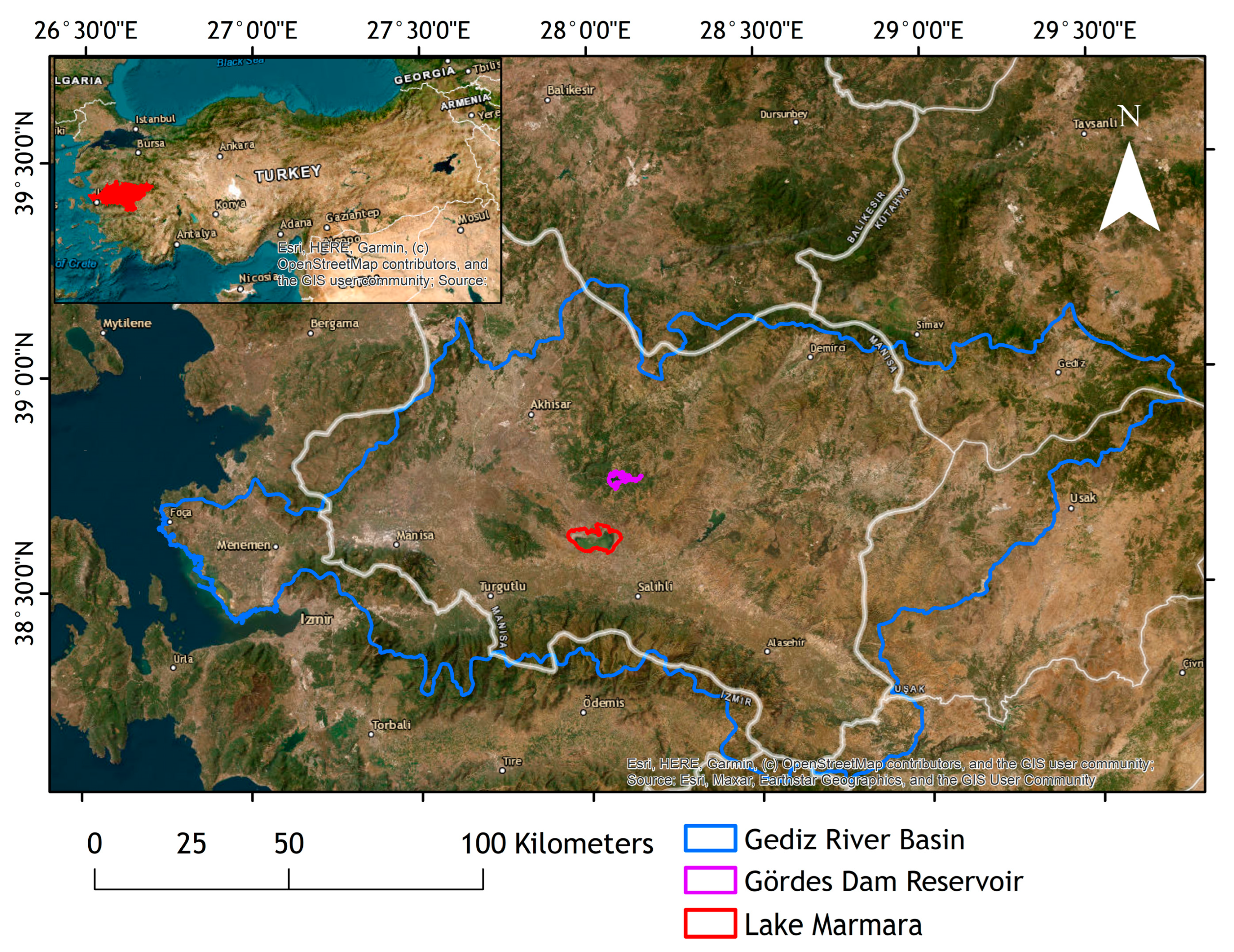
The presented study investigates the case of Lake Marmara, Türkiye, a wetland of national importance and also an important water source of the Gediz River Basin system. A series of water management choices has led the lake to dry up completely in the present situation. Within the scope of the PRIMA foundation-funded “Mara-Mediterra” project, the hydrological model of the Lake has been developed, and the impacts of climate change, land use change, and initial storage amount of Lake Marmara have been investigated [
34]. In this study, through modeling and scenario analysis, it is revealed that the lateral flows feeding the lake are insufficient to maintain a minimum ecological volume; namely, each scenario applied for the simulation of the monthly water balance of Lake Marmara resulted in a complete dry-up condition, without any inflow contribution from Gördes Reach.
Hence, this study investigates the possible solutions to restore Lake Marmara through a water accounting model to ensure the water balance of not just the lake but also the Gördes Dam and the demand sites related to these water resources. The previous study [
34] has considered the Lake Marmara watershed inclusively, excluding any water allocation from Gördes Dam, the main water source of Lake Marmara, and the demand sites related to the lake, only focusing on the water balance of the lake by lateral flows created by precipitation and drainage patterns of irrigated agricultural lands. Therefore, the presented study includes the scenarios covering a water allocation plan from Gördes Dam and Tabaklı reach directly to Lake Marmara. The scenarios are created regarding the combination of values such as the initial storage amount of Gördes Dam, changes in lateral flows and evaporation under future climate change conditions, irrigation supply priorities, irrigation demand management options, and the option of an investment in water diversion from a nearby reach of the Gediz River, the Tabaklı reach, to Lake Marmara, as scenario options. To systematically investigate these scenarios and their implications for restoration planning, a multi-tiered modeling approach was designed.
In this study, we developed an integrated modeling framework to explore feasible water allocation strategies for the restoration of Lake Marmara, located in the Gediz River Basin of western Türkiye. The methodology combines hydro-climatic analysis, reservoir storage scenarios, water demand management, and ecological flow prioritization using the Water Evaluation and Planning (WEAP) system. The model covers both historical meteorological data (1998–2006) and projected 2050 climate conditions based on the RCP 8.5 scenario. The study area encompasses Lake Marmara, Gördes Dam, and connected irrigation and environmental demand sites. Scenario-based simulations were conducted across multiple tiers, varying parameters such as dam storage levels, agricultural water supply priorities, and the inclusion of a potential 20 hm3/year diversion from the Tabaklı reach. Key performance indicators include minimum and maximum ecological storage targets for the lake, unmet water demands for agricultural and environmental uses, and long-term reservoir sustainability. This structured approach allows for an adaptive evaluation of restoration options under both current and future hydro-climatic stressors.
The results of the study, aside from the specific outcomes for Lake Marmara, highlight the importance of including each element of a hydrological system in an integrated water resources management principle and considering each investment option not only through present but also through future conditions.
2. Materials and Methods
2.1. Study Area
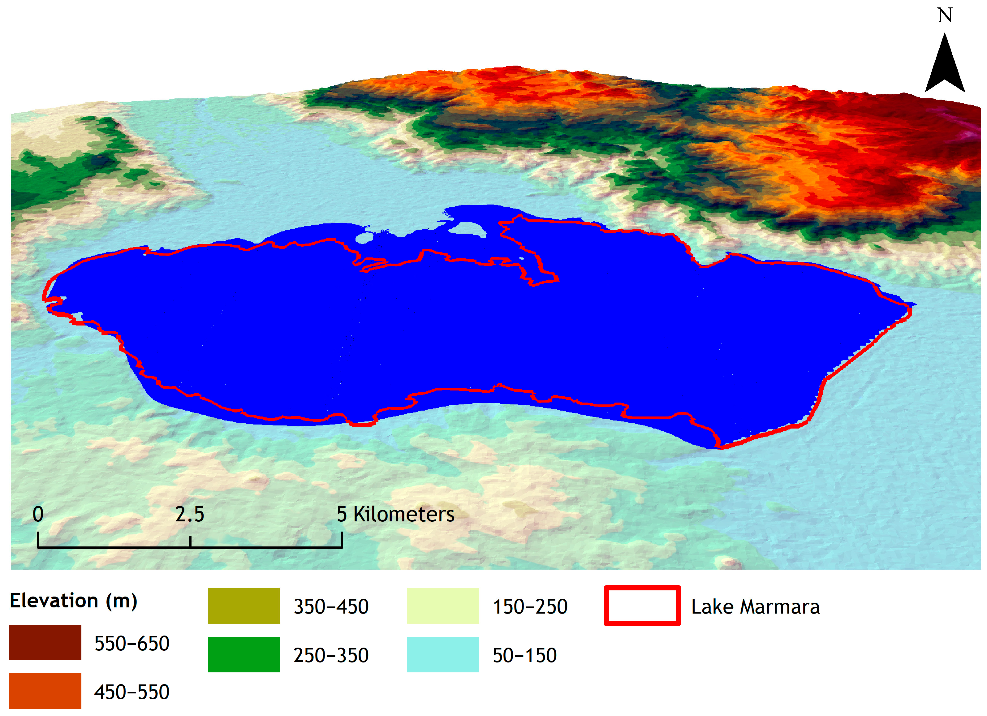
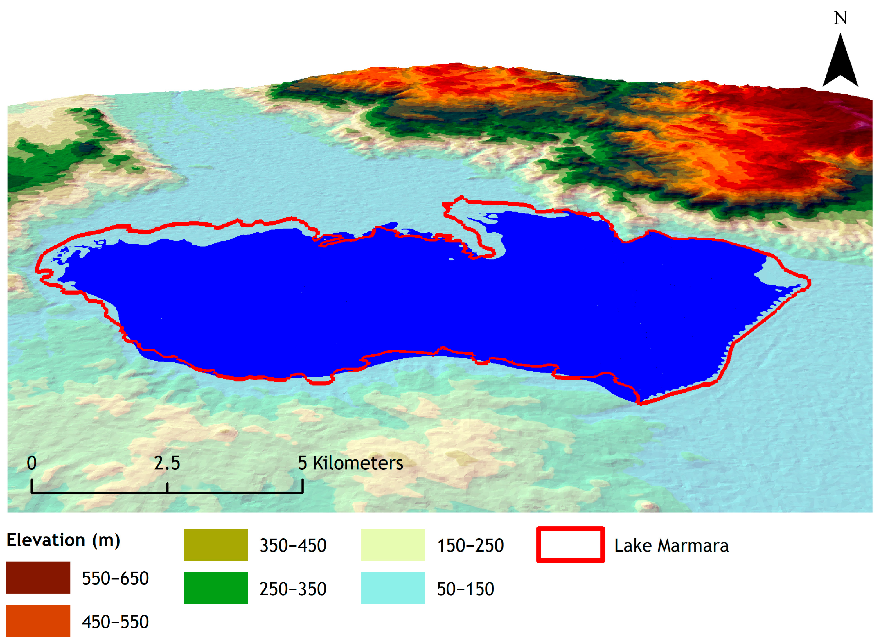
Lake Marmara is located in the west of Turkey within the boundaries of the Gediz River Basin (
Figure 1). The lake covers an area of 68 km
2 and is officially announced as a “Wetland of National Importance” with its ecosystem characteristics that host a large number of aquatic birds, various mammals, reptiles, and fish species [
35]. In and around the lake, aside from the extensive agricultural activities, which have a long history [
36], fishing and local tourism used to provide considerable economic advantages to the majority of the residents and communities. The lake water was mostly supplied by the Gördes Reach until the Gördes Dam was completed in 2011, which is primarily intended to contribute to the drinking water supply of Izmir’s urban area [
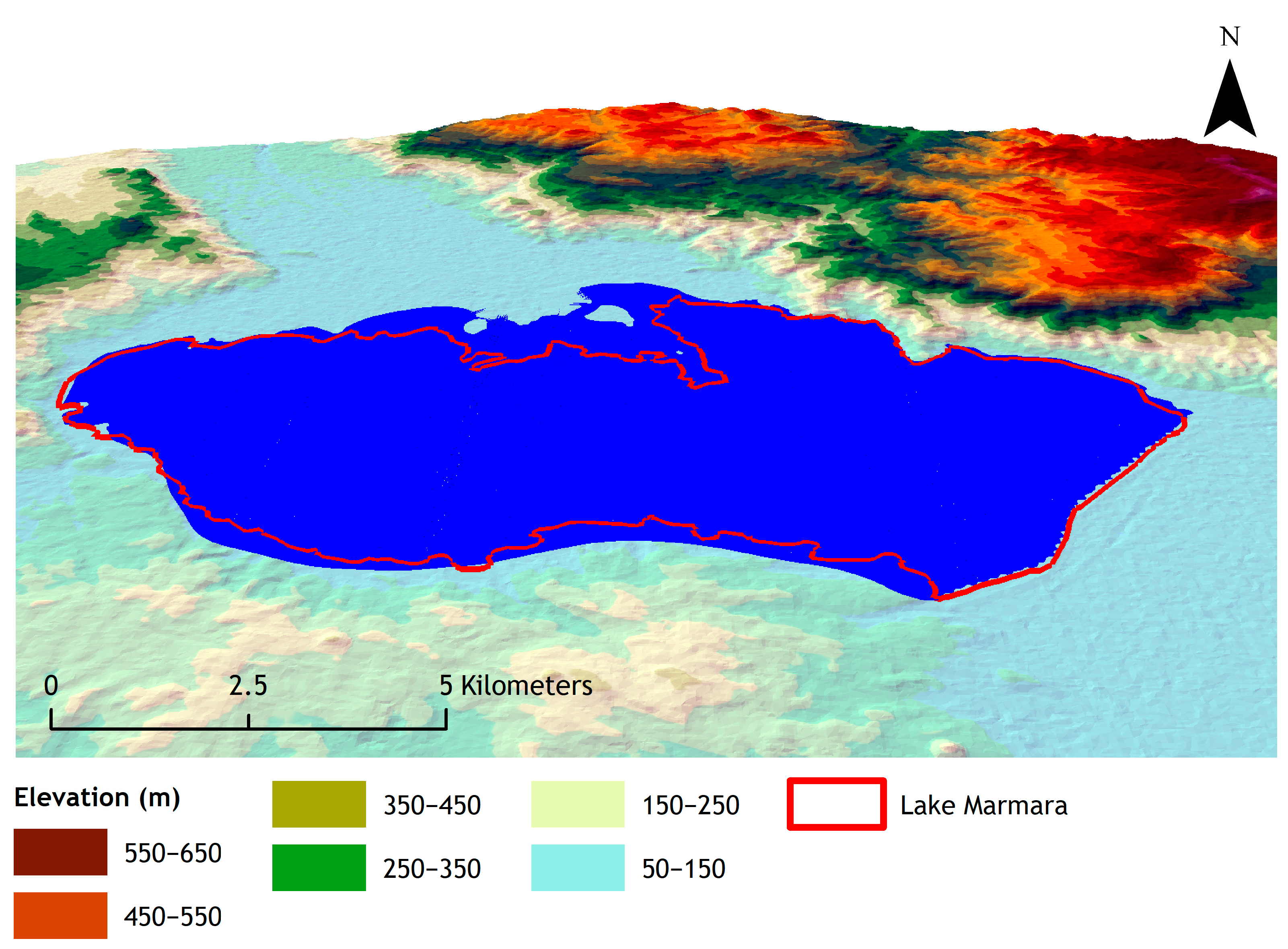
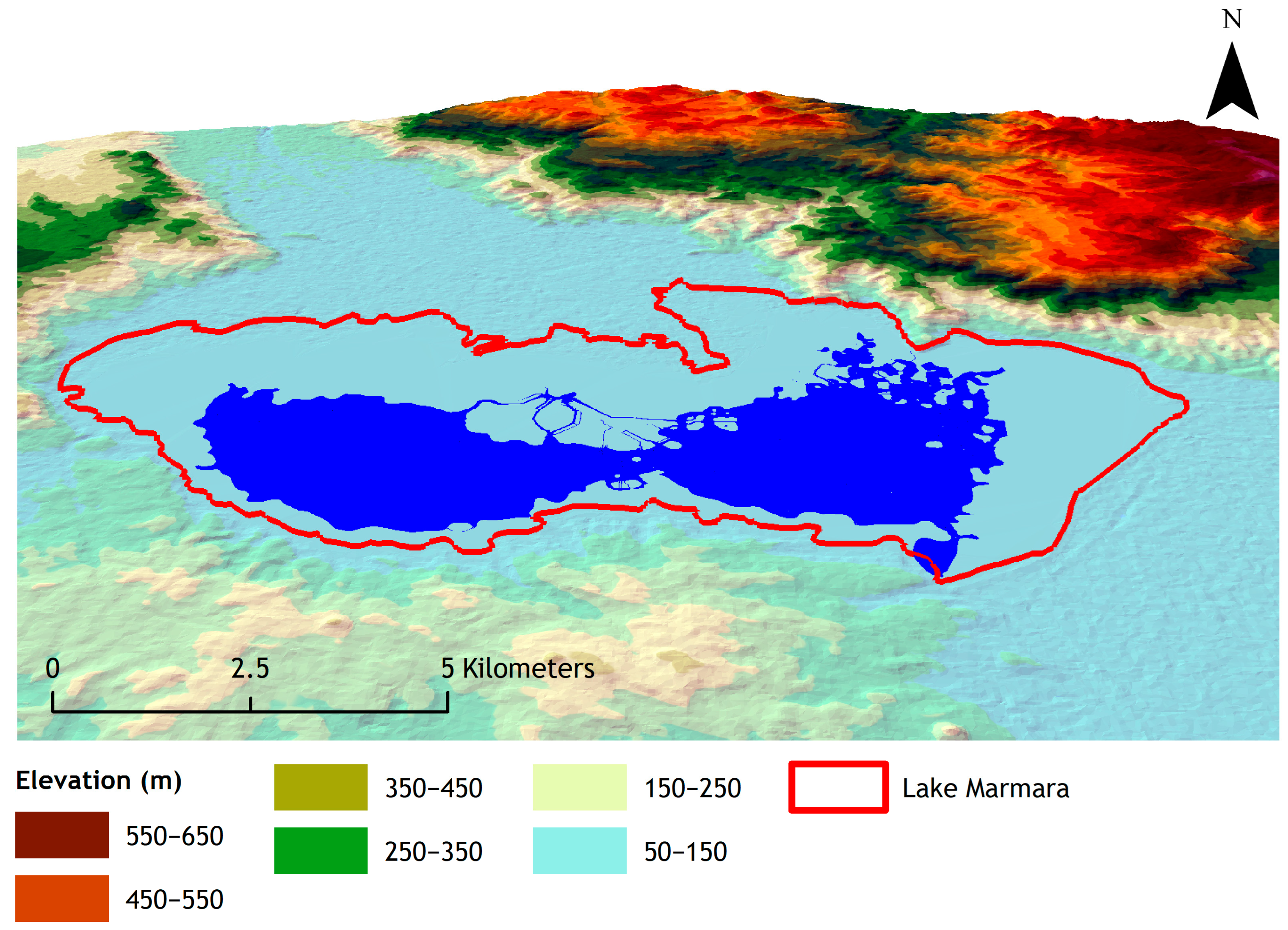
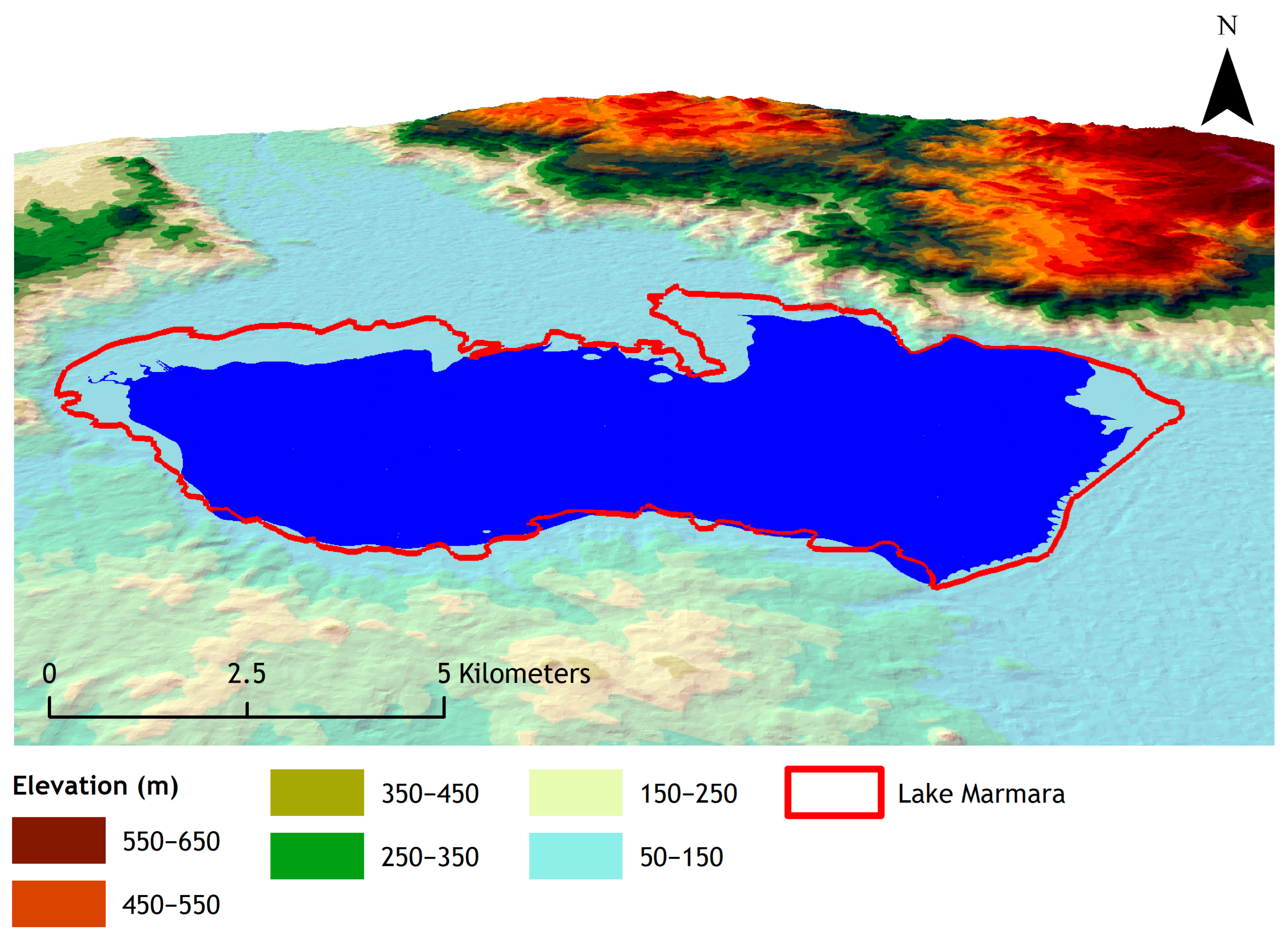
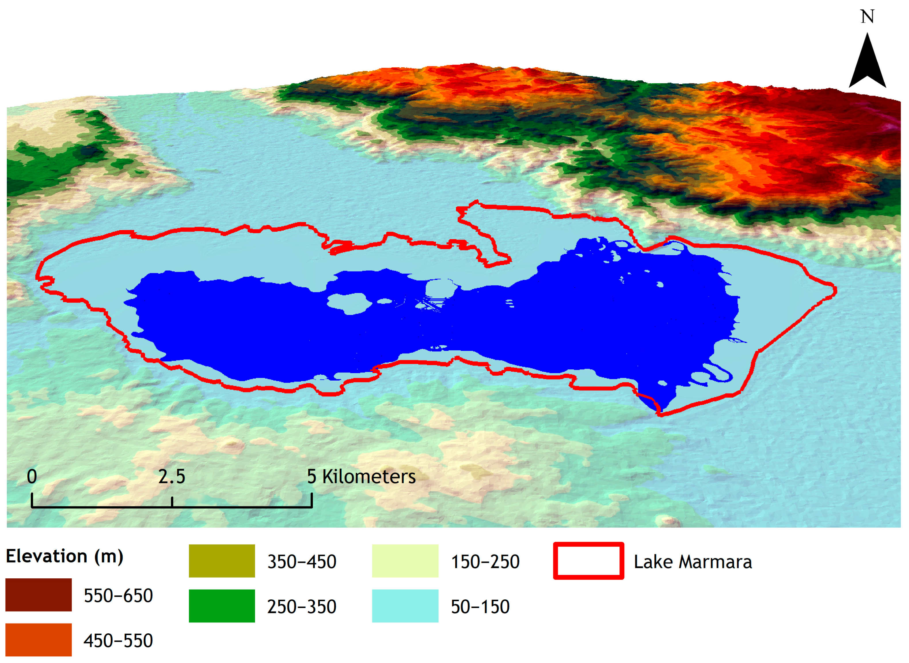
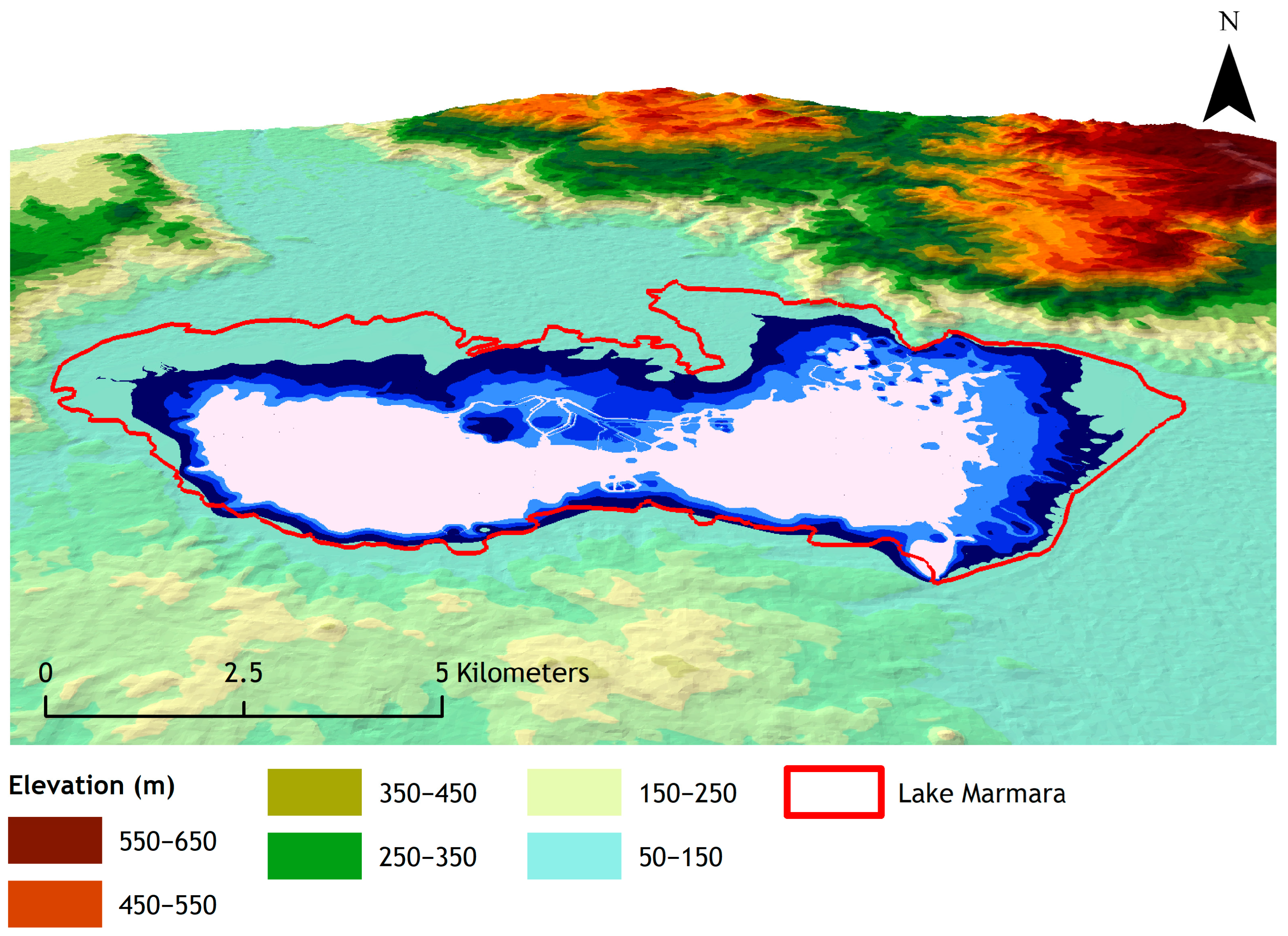
37]. The dam’s construction created additional rivalry for residential, irrigational, and environmental water demands in the region. The dam’s design and construction caused lower water allocation for the lake, while Gördes Reservoir failed to meet domestic and irrigational water demands due to leakage problems. This situation increased the vulnerability of the Lake, so the renewability of the wetland system has been severely damaged. Furthermore, the lake’s lateral inflows and runoff from precipitation were insufficient to maintain the requisite storage volume for environmental needs during dry periods (i.e., early summer to late fall), which also damaged its resilience. In addition, further irrigation water withdrawals from the lake exacerbated the water shortage, namely recoverability of the system has been lost. As a result, Lake Marmara has steadily dried up from 2019 until the present (
Figure 2), leaving restoration of the system as the only solution. Lake Marmara holds great significance as it plays a crucial role in the water balance of the Gediz River Basin.
The stakeholders of the area, especially the farming community, demand that the lake be restored to its former self. The interviews conducted with the local farmers within the scope of the “Mara-Mediterra” Project highlight the influence of the lake on the product quality in the area. As the farmers stated, the humidity, once emitted from the lake, used to protect their products, which are mostly Sultana grapes and olives, from extreme temperatures, preventing them from wilting and frost, so granting a higher production quality.
2.2. Data Source
Meteorological data for Lake Marmara were gathered by investigating three adjacent meteorological stations, Manisa, Akhisar, and Salihli, of the Turkish State Meteorological Services (DMI). Following a Thiessen method analysis, the Salihli meteorology station was determined to be the most suited, accounting for the representation of 97% of the lake drainage area. Thus, a collection of daily meteorological data collected at the Salihli station during a 32-year period (1980–2012) was used as input into the hydrological model.
To depict the terrestrial topography of the model region, ASTER-DEM version 3 data with a spatial resolution of 30 m were used as the basin’s Digital Elevation Model [
38]. The data on basin topography and hydromorphologic parameters were further analyzed using the ArcGIS program. Climate change data for RCP 8.5 [
39,
40] were obtained from the Global Climate Model (GCM) Downscaled Data Portal by the Research Program on Climate Change, Agriculture, and Food Security [
41].
2.3. Methods
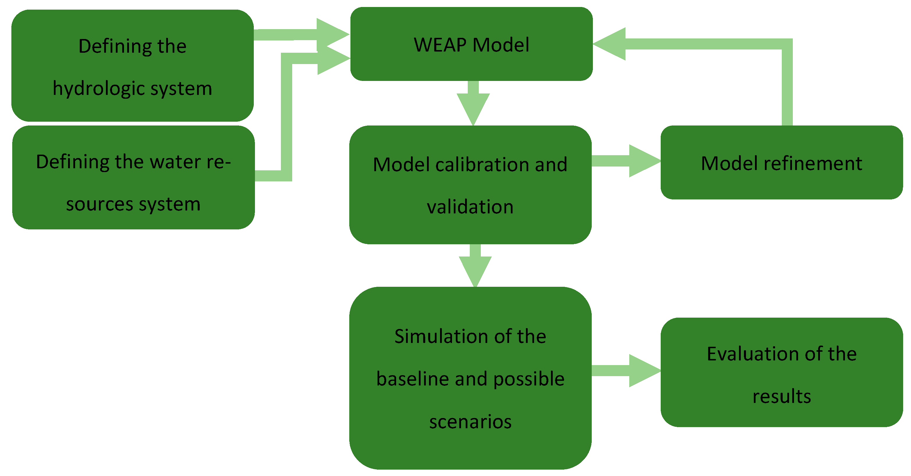
In order to investigate dynamic water allocation options and simulate various conditions and constraints on the study area, a set of models has been used and/or developed. The main mathematical model developed for this study is the water accounting model developed in the WEAP software (WEAP21) [
42]. The WEAP uses a water balance equation to determine the Lake Marmara storage in baseline and scenario results.
where Δ
S is storage change in the lake,
P is precipitation over the lake,
Qin is inflow from Gördes Dam and Tabaklı reach (in scenarios where Tabaklı reach is identified),
E is evaporation losses from the Lake,
Qout is spill or downstream releases, and
D is water demand withdrawals (irrigation, domestic, and environmental). All defined element units in the equation are hm
3/month. WEAP model goodness-of-fit statistics have been presented in
Table A1, whereas the modeled and observed data comparison is given in
Figure A1.
Additionally, the study uses key results of a previous paper by Gunacti et al. [
34] regarding the land use change and hydrological modeling of the Lake Marmara system. The mentioned study investigated the hydrological potential of Lake Marmara under land use and climate change impacts. The land use change was modeled by the TerrSet 2019 software’s Land Use Change Modeler (LCM) tool to project the land cover map of 2050 around Lake Marmara. On the other hand, the Hydrologic Modelling System (HEC-HMS) was used to model the hydrological processes of the Lake Marmara system for the baseline period of 1998–2006 and the future projection of 2050.
As stated, the water allocation modeling component of the study is conducted by the WEAP software developed by the Stockholm Environment Institute (SEI). WEAP is a software tool that is commonly used in studies that are focused on integrated approaches to water resources planning problems. WEAP provides several built-in models for rainfall runoff and infiltration, evapotranspiration, crop requirements and yields, surface water/groundwater interaction, and instream water quality on a monthly time scale. It also serves to identify the variables and equations on the relations between the elements of the basin and the processes involved. WEAP is linked to a GIS interface to build up the topology of the entire basin and the links between demand and supply nodes. The basin system is defined in terms of its supply sources (e.g., rivers, creeks, groundwater, reservoirs, and desalination plants); withdrawal, transmission, and wastewater treatment facilities; water demands; pollution generation; and ecosystem requirements (
Figure 3). The modeling flowchart of a common WEAP Model is given in
Figure 4.
Different allocation patterns lead to different responses to existing water demands. These patterns affect the whole system’s survival in terms of water quantity. The WEAP model relies on scenario analysis to evaluate the effects of policy changes. The scenarios generated in this study are based on climate change and the implementation of demand management actions. Furthermore, the storage time series of Lake Marmara and the unmet demand of the Lake Marmara region have been calculated for each scenario and presented in the results section.
In this study, the performance of each scenario was quantitatively assessed based on the volume of unmet water demand across the irrigation and environmental sectors. This indicator, automatically generated by the WEAP model, represents the shortfall between the required water and the actual supplied amount at each time step. It is defined as
Here, i represents the demand site (e.g., irrigation, environment), and t refers to the time step in monthly resolution. Unmet demand was used to compare scenario performance with respect to both ecological and agricultural priorities under present and projected hydro-climatic conditions.
2.4. Scenario Development
In the previously mentioned study by Gunacti et al. [
34], a set of developed scenarios investigated the hydrological potential of Lake Marmara by lake water budget calculations, where the irrigational water demand management, impacts of land use and climate change, and initial reservoir storage were the scenario variables. Unfortunately, in this group of scenarios, Lake Marmara dried out in each one of them.
This brings us to the current study, in which the scope of modeling has been widened to a larger extent, as every demand management scenario under either climate or land use change falls short of sustaining the minimum environmental requirements. Since this section requires much more complex calculations, the WEAP model has been employed in this segment. The scenarios developed in this section involve actions such as allocating water from other branches or considering a sustainably working Gördes Dam.
In particular, scenarios first evaluate the necessity of Tabaklı reach investment, which is to allocate 20 hm
3 of water each year from Tabaklı reach to Lake Marmara. Then, if the investment is not necessary, the second level of scenarios investigates the impact of the initial storage of Gördes Dam on the storage of Lake Marmara and the total unmet demand of Lake Marmara’s irrigational needs. This is investigated in 4 sub-scenarios where the initial storage of Gördes Dam is a quarter, half, three-quarters, and the total of its storage capacity. Hence, according to the results of this level of scenarios, another level of scenarios investigates the future conditions in two variations, either with or without allocating irrigational water to the agriculture sector. This tier of scenarios also investigates the satisfaction of the minimum and maximum ecological water needs (
Figure 5 and
Table 1 and
Table 2).
3. Results
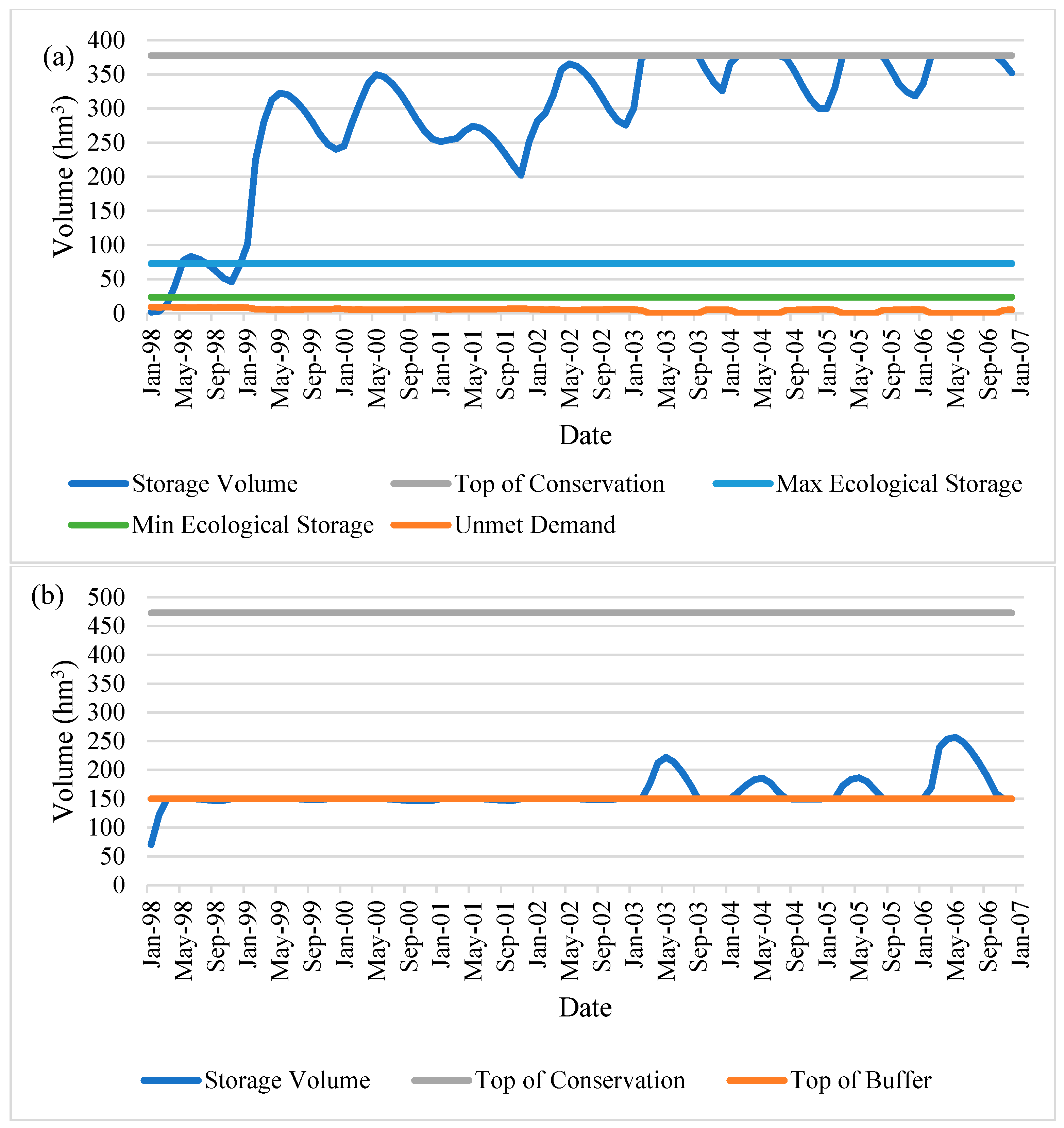
The first tier of scenarios, where the necessity of Tabaklı investment, which is to allocate 20 hm
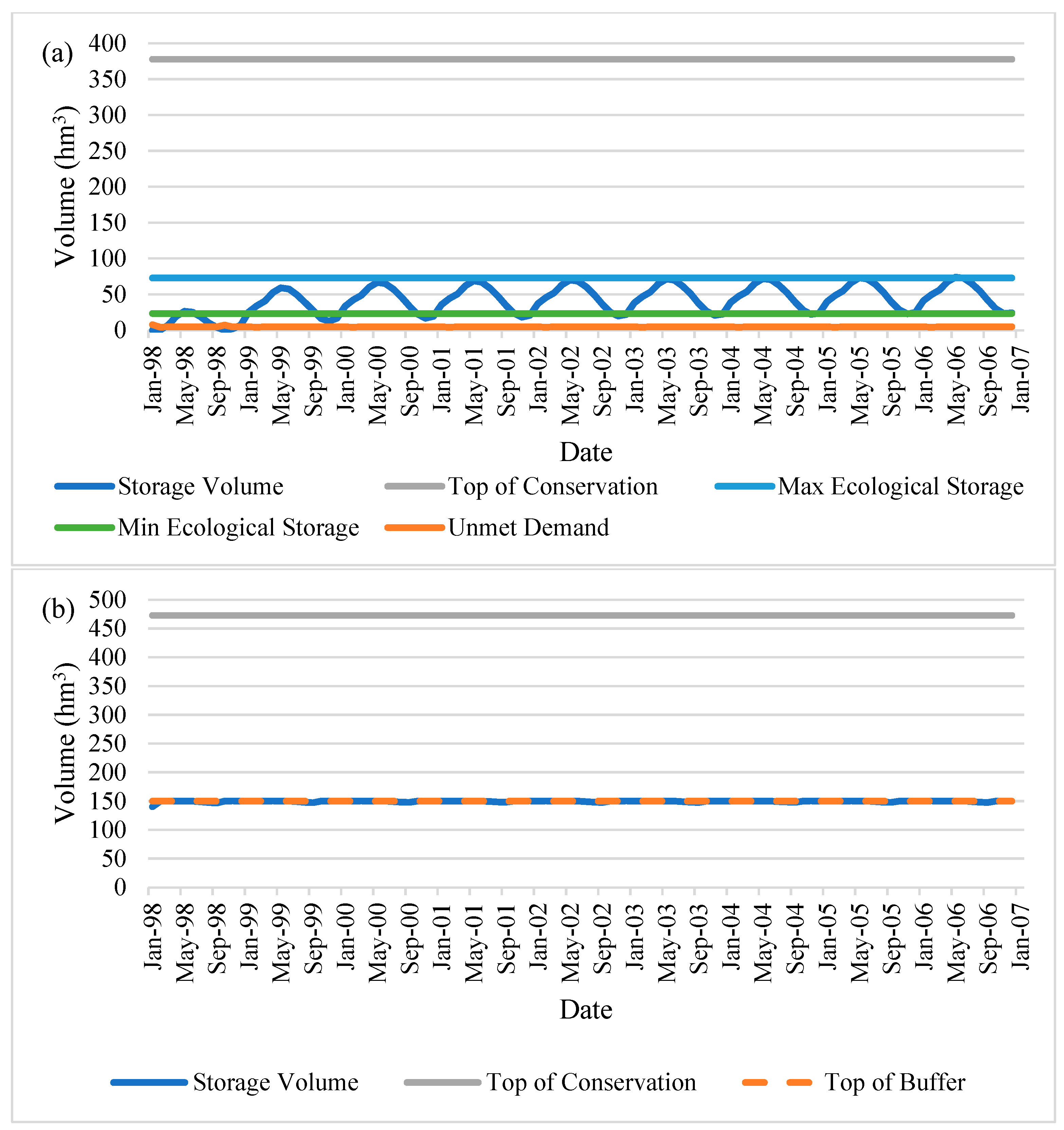
3 of water to Lake Marmara, is investigated, reveals that in the short-term results, this investment (scenario S1) is not necessary for the environmental needs of the Lake (
Figure A2) when compared to the case without the investment (scenario S2) (
Figure A3). In both cases, Gördes Dam retains the minimum volume required to function (150 hm
3), and Lake Marmara satisfies both the annual minimum (23.47 hm
3) and maximum ecological water demand (72.85 hm
3) assumed according to the future dry year scenario and baseline scenario. Lake volumes were investigated in Gunacti et al. [
34]. The ArcScene 3D render visuals of the Lake at the end of the simulation period, with the average Lake boundary comparisons, are also provided in each scenario result for better visual understanding (
Figure 6 and
Figure 7).
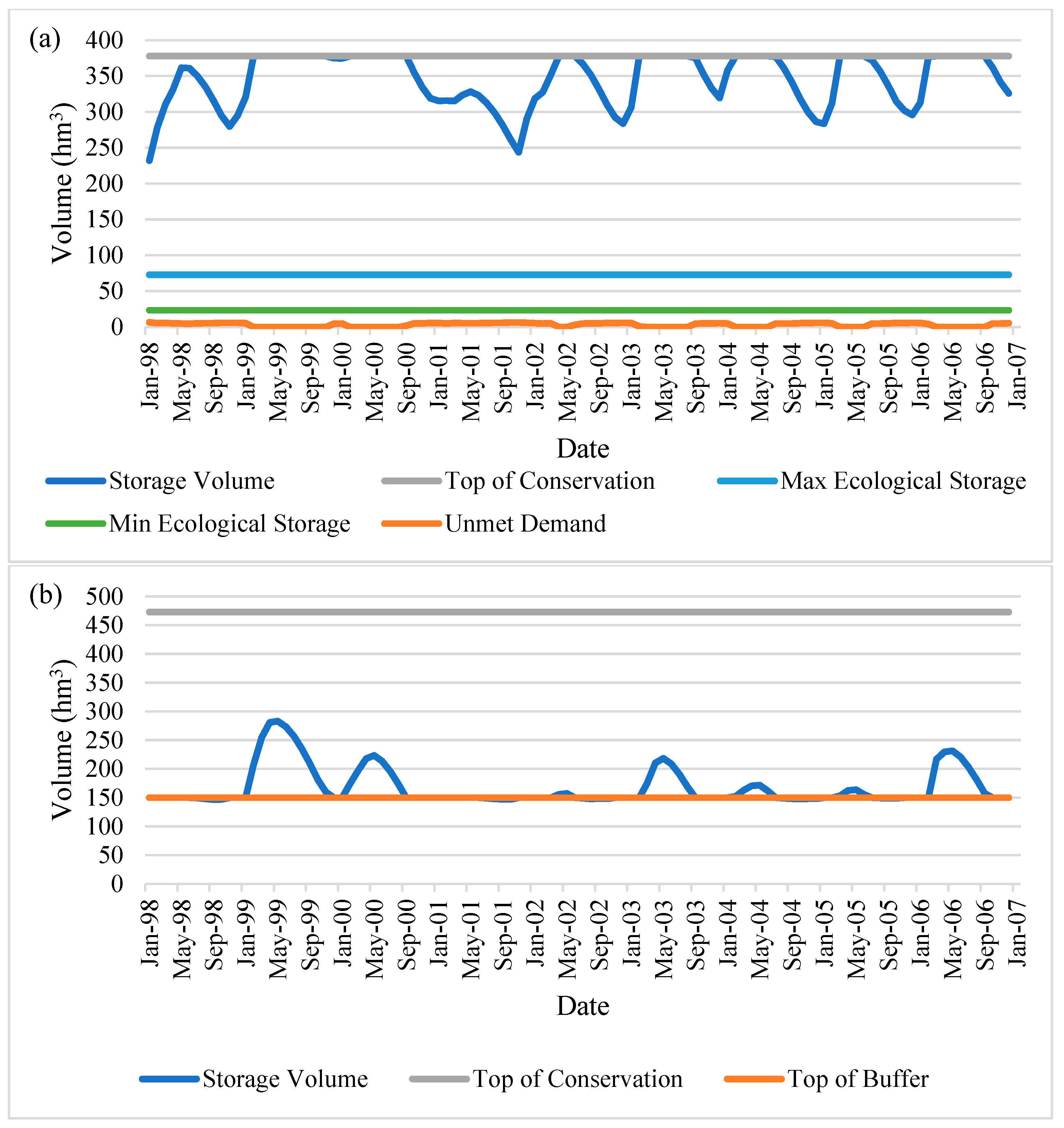
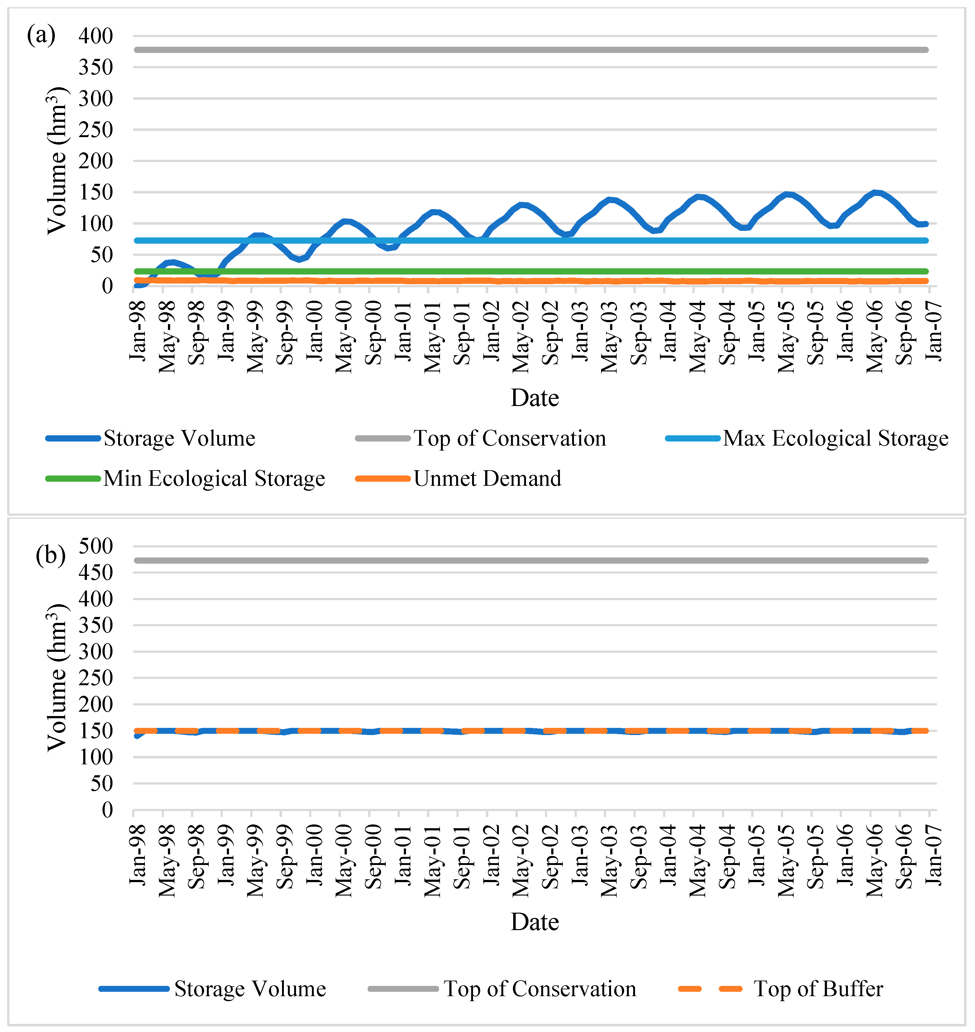
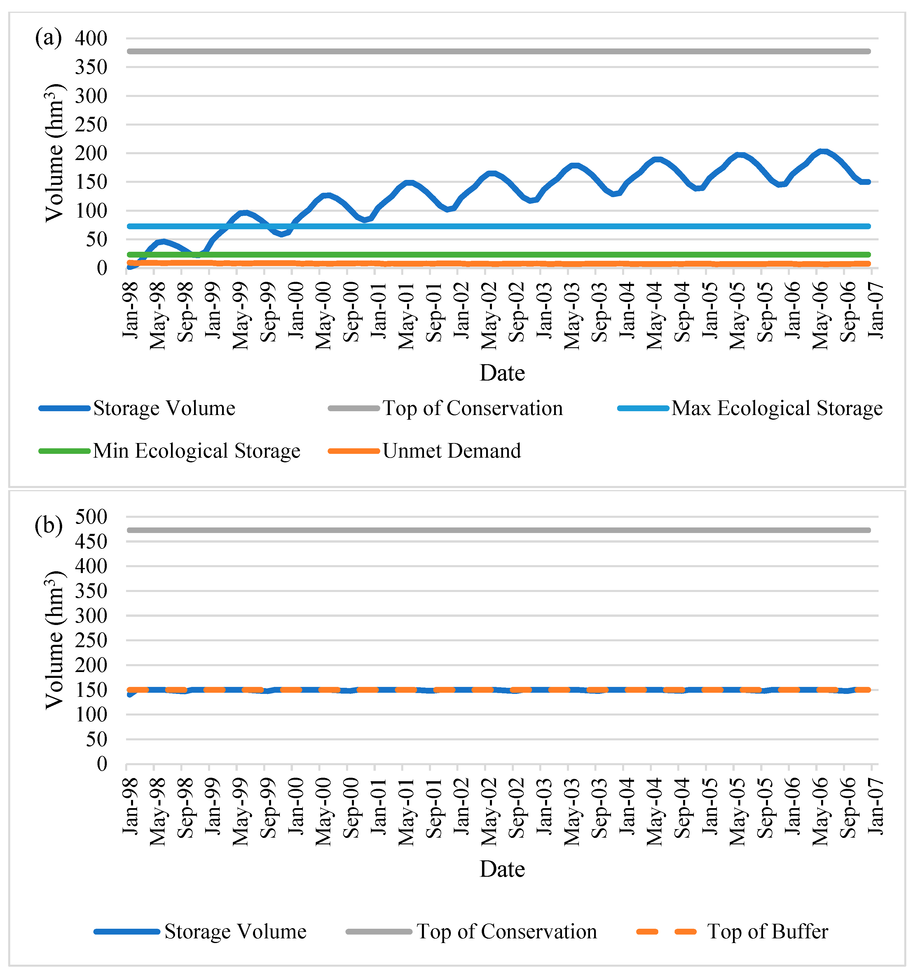
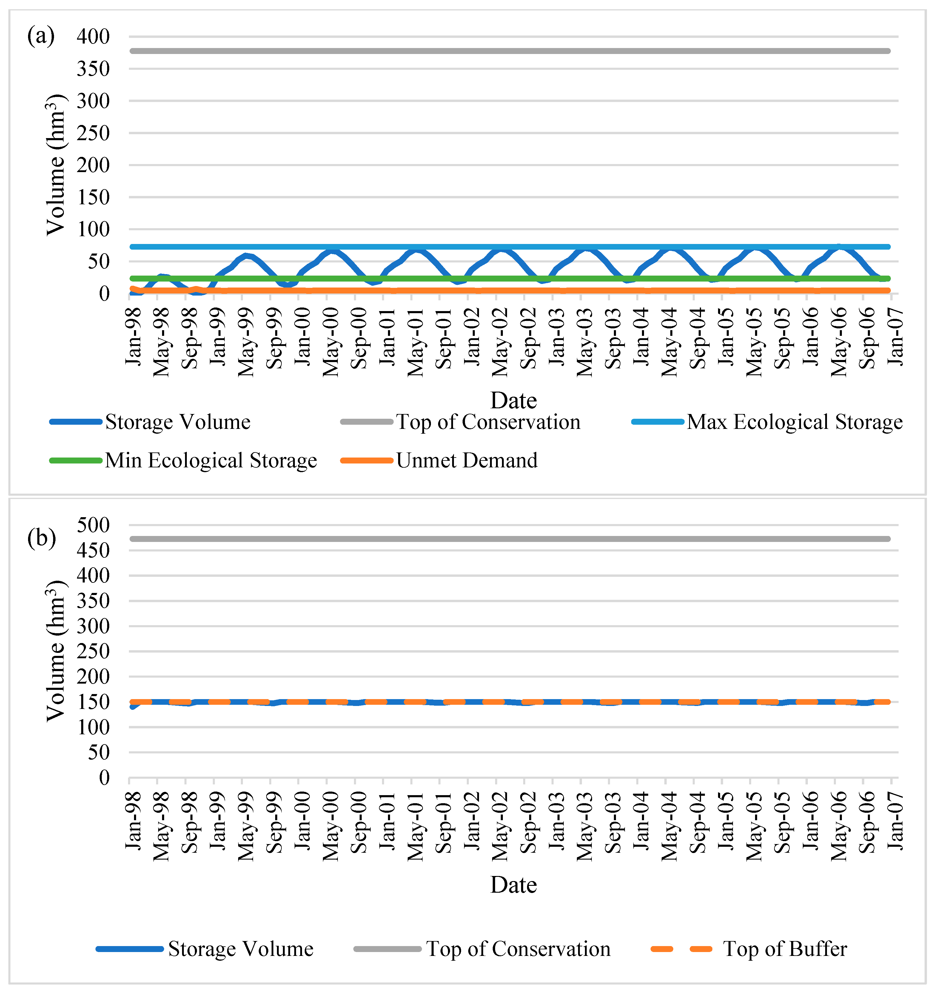
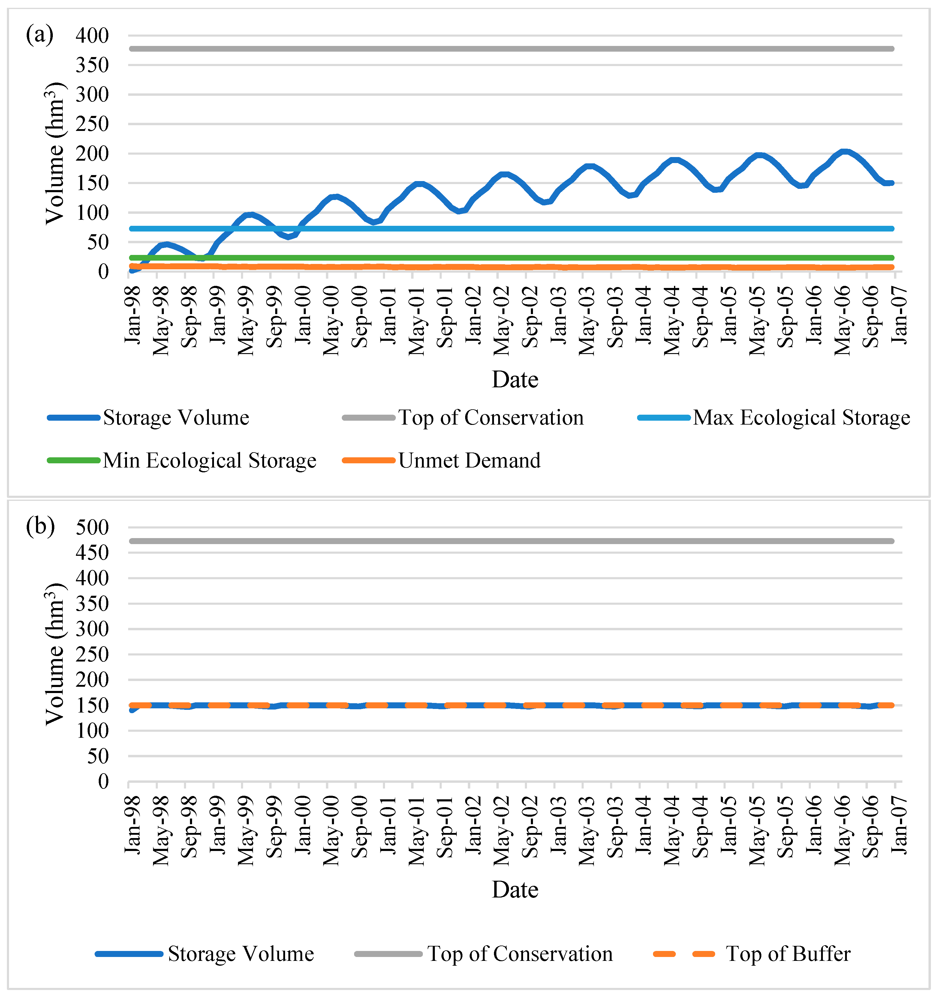
Therefore, the scenarios continue on without the Tabaklı investment into the second tier, where the impact of initial storage in Gördes Dam is investigated. The scenarios S2.1, S2.2, S2.3, and S2.4 indicate the initial storage in Gördes Dam to be a quarter, half, three-quarters, and the total of its storage capacity, respectively. In this tier of scenarios, every scenario has satisfied the annual minimum and maximum ecological water needs and the minimum storage amount in Gördes Dam (
Figure A4,
Figure A5,
Figure A6 and
Figure A7,
Figure 8,
Figure 9,
Figure 10 and
Figure 11). This outcome indicates that there is no need to wait until the Gördes Dam is half, three-quarters, or entirely full to start its operation. The Dam can operate even in lower conditions, which is proven in the first tier of investigation by using the observed initial storage amount (40.2 hm
3), which was lower than a quarter of the total storage capacity (118.25 hm
3).
It is important to note that the similarity among Scenarios S2, S2.1, and S2.2 is not a limitation but a critical finding in itself. The fact that comparable lake volumes were achieved even with low initial reservoir storages (e.g., 40.2 hm
3 in S2) demonstrates that full-capacity conditions are not required to initiate effective operation of Gördes Dam. In other words, ecological and sectoral water demands can still be satisfied without waiting for the reservoir to reach its maximum storage. This insight has substantial implications for real-world reservoir operation policy, especially in water-scarce regions. Furthermore, this interpretation is reinforced by the outcomes of Scenarios S2.3 and S2.4 (
Figure 10 and
Figure 11), which simulate ¾ and full-capacity conditions, respectively.
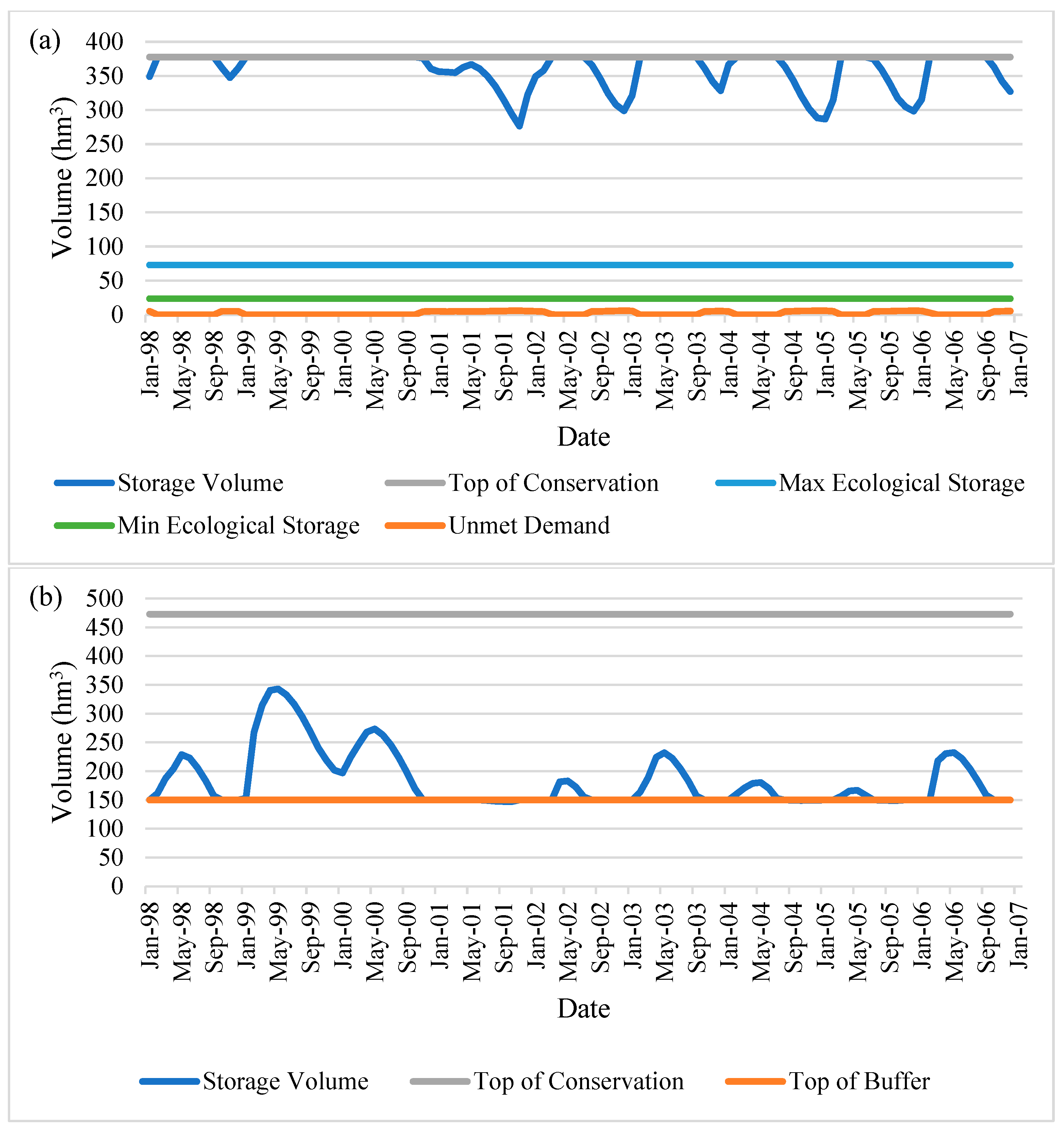
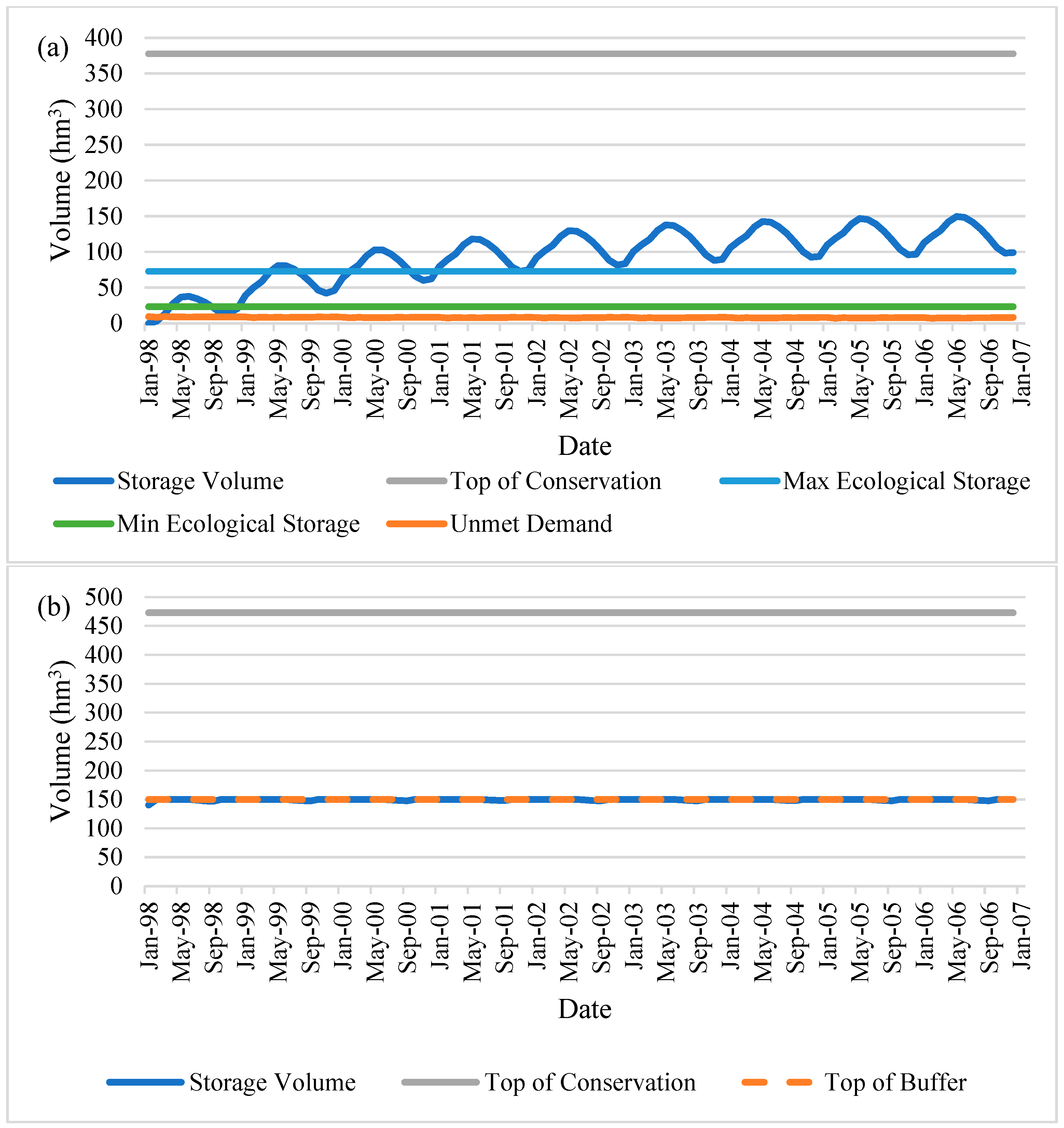
This brings us to the third tier of scenarios, where the meteorological conditions of 2050 are simulated not only for one year but also for nine years, the same length as the 1998–2006 period. In this section of the scenarios, the calculated 2050 streamflow output of Gunacti et al. [
34] is used as input for Gördes Dam for nine repetitive years to observe its mid-term impacts on the Lake Marmara system. This tier of scenarios also investigates three more conditions: providing irrigational water for agriculture (or not), supply priority of environmental water needs being the first (or the second), and lastly, reintroducing the option of Tabaklı investment would be necessary in the future (or not) (
Figure A8,
Figure A9,
Figure A10,
Figure A11,
Figure A12,
Figure A13,
Figure A14 and
Figure A15,
Figure 12,
Figure 13,
Figure 14,
Figure 15,
Figure 16,
Figure 17,
Figure 18 and
Figure 19).
In order to stress the worst-case scenario results, which is the S2.1.1.2, where the 2050 meteorological conditions are in effect without the Tabaklı investment and the supply priority of environmental needs is in second order, the average seasonal storage of Lake Marmara is 3D rendered in
Figure 20.
4. Discussion
4.1. Scenario-Based Insights on Lake Restoration
The scenario-based analysis demonstrates the varying capacities of Gördes Dam to satisfy the ecological needs of Lake Marmara under both current and projected climate conditions. Scenario S1, which includes water diversion from the Tabaklı reach, consistently succeeded in meeting minimum lake volume thresholds, even under future climate stress. In contrast, Scenario S2 (no Tabaklı diversion) showed adequate ecological performance only under present conditions. Within Scenario S2 variants, storage volumes were slightly higher with increased initial reservoir levels (e.g., 323.51 hm3 in S2.2 vs. 322.49 hm3 in S2.1), indicating operational gains even at sub-optimal capacities. The marginal volume differences among S2, S2.1, and S2.2 imply that full-capacity operation is not necessary to initiate restoration. This is further validated by Scenarios S2.3 and S2.4, where additional storage produced only slight incremental improvements. These outcomes collectively suggest that timely prioritization of ecological flows can be more critical than maximizing reservoir volume.
Moreover, the results of this study indicate that, under current hydrological conditions, Lake Marmara can sustain its minimum and maximum ecological water needs—restoring key aquatic habitats, supporting vegetation regrowth, and providing potential for improved biodiversity. However, under 2050 climate projections, scenarios that deprioritize ecological flow or omit infrastructural support (e.g., the Tabaklı diversion) result in severe reductions in lake volume and continuity. These outcomes suggest a high risk for habitat fragmentation, decline in aquatic species, and further loss of wetland vegetation—echoing findings from similar Mediterranean-climate systems (e.g., Doñana wetlands in Spain). Changes in seasonal storage also imply likely impacts on sedimentation patterns, eutrophication risk, and the disruption of ecosystem service functions such as nutrient cycling and carbon sequestration [
43,
44].
4.2. Management Implications for Semi-Arid Wetlands
The findings hold important implications for wetland restoration strategies in semi-arid regions. The modeling results indicate that significant ecological restoration can be achieved without relying on full reservoir storage. This insight challenges conventional water allocation paradigms that prioritize reservoir maximization. Particularly under changing climate regimes, flexible reservoir operation that prioritizes environmental flows could be more sustainable and cost-effective. The results also show that marginal improvements in storage provide diminishing returns in terms of lake recovery, highlighting the importance of prioritization over expansion. Such adaptive planning approaches are crucial for basins like the Gediz, where water scarcity and intersectoral competition are intensifying.
The degradation of Lake Marmara has already disrupted agricultural productivity, local microclimates, and traditional livelihoods, including fishing and viticulture. Model outputs show that failure to prioritize ecological flows under future conditions may exacerbate water scarcity during summer months, reducing water availability for downstream agricultural areas. This, in turn, may intensify competition over limited water supplies and increase the vulnerability of smallholder farmers, many of whom rely on stable lake conditions for microclimatic regulation, especially in grape and olive production. Furthermore, increased variability in seasonal storage could intensify flood and drought cycles, affecting both infrastructure and crop resilience.
4.3. Comparison with International Case Studies
Similar trends have been observed in international studies. Thompson et al. [
29] demonstrated in UK floodplain wetlands that ecological targets could be met under various climate scenarios through adaptive water routing rather than structural expansion. Fahrländer et al. [
28] noted that prioritizing upstream ecological flows in China significantly improved downstream Ramsar wetlands. Conlisk et al. [
31] emphasized the benefits of reintroducing tidal flows for carbon and methane regulation in North American wetlands. These findings align with our results, reinforcing that operational strategies focused on ecological performance can be effective even under hydrological stress. The global consistency in these outcomes underscores the transferability of adaptive management frameworks.
4.4. Limitations and Future Research Directions
This study has several limitations. First, it does not incorporate groundwater–surface water interactions, which are particularly relevant for long-term lake sustainability. Second, while ecological thresholds were defined in terms of lake volume, more nuanced ecological indicators (e.g., species-specific habitat needs, vegetation health) were not included. Third, the economic and institutional feasibility of implementing the recommended scenarios was not assessed. Future research should explore coupled surface–groundwater modeling, integrate biodiversity indicators, and assess economic trade-offs and stakeholder dynamics. Additionally, socio-economic impacts such as agricultural productivity, livelihood shifts, and ecosystem service valuation merit inclusion in subsequent studies to broaden the policy relevance of the findings.
The findings underscore the importance of integrating hydro-climatic projections into long-term wetland management strategies. Scenario outcomes reveal that adaptive reallocation—rather than reliance on large-scale infrastructure alone—can meet ecological water requirements under present conditions. However, under future climate stress, infrastructural investments such as the Tabaklı reach diversion may become necessary. Policy frameworks should therefore institutionalize environmental flow prioritization, flexible dam operations, and periodic reassessment of water allocations. Moreover, local and regional planning authorities should incorporate hydro-climatic modeling into land use, agriculture, and biodiversity conservation plans. This study supports the use of scenario-based modeling tools like WEAP as planning instruments that can bridge ecological needs with socio-economic and governance priorities under climate uncertainty.
5. Conclusions
This study explored a range of water resource management strategies and meteorological scenarios to identify viable pathways for the restoration of Lake Marmara—a nationally significant wetland within the Gediz River Basin of Türkiye. Once a thriving aquatic ecosystem, Lake Marmara has undergone significant degradation due to a combination of dam operations, irrigation withdrawals, and climatic stressors. Through scenario-based modeling, the research demonstrated that ecological restoration is feasible under current hydrological conditions without immediate large-scale infrastructure investments.
Results revealed that limited storage in Gördes Dam, if managed with ecological priorities, can satisfy the lake’s environmental needs in the near term. However, under projected 2050 climate conditions, this balance becomes fragile. Scenarios that deprioritize ecological flows or exclude infrastructure such as the Tabaklı diversion fail to maintain minimum thresholds for lake health. Conversely, integrated strategies that combine adaptive reservoir operations with supplementary infrastructure offer more resilient outcomes.
The most significant contribution of this study lies in its demonstration that dynamic, scenario-based water allocation models—when combined with hydro-climatic projections—can offer practical and forward-looking solutions for wetland restoration under climate uncertainty. By integrating hydrological infrastructure (e.g., reservoir storage), ecological flow requirements, and projected climate stressors, the framework can be applied beyond the case of Lake Marmara to other semi-arid and Mediterranean-type basins facing similar degradation trajectories. Specifically, the finding that short-term ecological restoration may be achieved without immediate large-scale infrastructure, while long-term sustainability requires strategic adaptation, is a valuable insight for both researchers and policymakers.
A primary limitation of the study lies in its simplified socio-economic representation. While the model captures physical and policy-based constraints, it does not account for economic feasibility, institutional dynamics, or stakeholder behavior, all of which play critical roles in real-world implementation. Moreover, while the WEAP model supports detailed hydrological scenario analysis, it does not simulate ecosystem feedbacks or long-term ecological responses to partial restoration. Future research should explore these dimensions using integrated modeling frameworks that combine ecological valuation, policy analysis, and participatory planning to enhance the practical applicability of scenario-driven wetland management.
In conclusion, while the degradation of Lake Marmara reflects the cumulative impact of long-standing mismanagement and climatic stress, its future need not be defined by further decline. Through strategic planning, prioritized ecological investments, and adaptive governance, the lake’s hydrological and ecological functions can be revitalized. However, the window of opportunity is narrow, and timely action will be crucial to avoid irreversible ecological loss and to secure the resilience of both natural ecosystems and the communities that depend on them.


