1. Introduction
Floor water inrush is a critical hazard in coal mining [
1,
2]. The presence of pressurized aquifer water in the floor, under high pressure, can result in sudden water surges in the mining space. In addition, the hydrogeological conditions in China are complex, and the mining scale of coal mines is relatively large, posing severe risks to mine safety [
3,
4,
5]. The consequences of a water inrush can range from localized flooding of the working face to complete inundation of the mine [
6,
7]. To ensure coal mining safety, a comprehensive analysis of geological conditions, hydrogeological characteristics, mining technology and other mine-specific factors is essential. Based on this analysis, an effective algorithm for water inrush risk assessment should be developed [
8,
9,
10], enabling scientific prediction and assessment of potential risks [
11,
12,
13]. This approach will allow mine managers to take preventive and corrective measures, reducing the likelihood of future water inrush incidents.
The assessment of coal mine floor water inrush evaluates the probability and potential of such events by analyzing key influencing factors. Currently, several experts have made significant advancements in evaluating and preventing risks associated with coal mine floor water inrush risks. For instance, Sun et al. [
14] developed a water inrush risk model using an analytic hierarchy process–entropy method (AHP–EM) and constructed a water abundance structural index model through coupled geologic data calculations. This model provides a comprehensive framework for assessing water inrush risks in mines, aiding in the prevention and management of water hazards. Li and Sui [
15] proposed risk assessment indices specific to coal floor water inrush, taking into account the area’s geological and hydrogeological characteristics. They further developed a comprehensive evaluation model (CEM) by integrating principal component logistic regression analysis (PCLRA) and an improved analytic hierarchy process (IAHP). In comparison to the traditional water inrush coefficient method (WICM) commonly used in China, this model exhibits a higher degree of fit and provides a more detailed delineation of the water inrush risk area. Bai et al. [
16] applied the AHP along with criteria importance through the inter-criteria correlation (CRITIC) method to assess inrush risk zones within Coal Seam 1 of Liuzhuang coal mine, demonstrating the AHP–CRITIC method’s enhanced accuracy over traditional AHP. Zhao and Gu [
17] present a method for evaluating the risk of floor water inrush that utilizes combined weighting and AHP. This method, based on the GIS (Geographic Information System), integrates an optimized comprehensive weighting mathematical model with the vulnerability index method to determine water inrush risk division. This approach provides a more accurate representation of water inrush in mining areas. Although the aforementioned studies have effectively mitigated the shortcomings of single-method approaches and reduced one-sided results, their findings remain insufficiently accurate due to the continued reliance on traditional and highly subjective evaluation methods.
Some researchers have explored the application of machine learning algorithms to assess sudden water inrush events in coal mines. For example, Zhang et al. [
18] utilized the principal component analysis–deep belief network (PCA–DBN) model to extract water inrush features effectively, achieving improved predictive accuracy and establishing a more reliable evaluation model for water inrush accidents. Li et al. [
19] developed a deep learning classification model for mixed water sources in mines based on genetic algorithm–extreme gradient boosting (GA–XGBoost), significantly improving the accuracy of the discriminative model and providing a novel approach to identify water inrush sources. Ye et al. [
20] proposed a water inrush prediction method using a neural network based on the improved SMOTE (ISMOTE) algorithm. This method promotes the application of deep learning in predicting water inrush events in coal mines and has both theoretical and practical significance. However, machine learning algorithms necessitate a large number of quality data samples. When the data set is limited, the accuracy of the results obtained from machine learning algorithms is significantly reduced, increasing the likelihood of prediction bias.
Based on the aforementioned research on coal mine water inrush evaluation, many existing methods are inevitably subjective or primarily suitable for large datasets. However, methods are still lacking for analyzing small sample data. Therefore, this paper proposes the principal component analysis–rough set theory (PCA–RST) method, which mitigates subjectivity and is applicable to small samples. We establish a water inrush evaluation index system and model for the 3602 working face of the Chenmanzhuang Coal Mine. We conduct an objective and comprehensive examination of the key factors influencing water inrush from the floor plate, assign corresponding weights to the evaluation indices, construct an evaluation model, create relevant contour diagrams, quantify water inrush risk, classify risk levels, and determine the water-inrush hazard area. The objectives of this study are (1) to reasonably select the key factors influencing floor plate water inrush and establish a risk evaluation model; (2) to propose a novel evaluation method and assess its accuracy and feasibility for evaluating the risk of coal seam floor plate water inrush; and (3) to develop targeted prevention and control measures to mitigate the risk of water inrush, providing a scientific reference for similar predictions in coal mines.
2. Overview of the Study Area
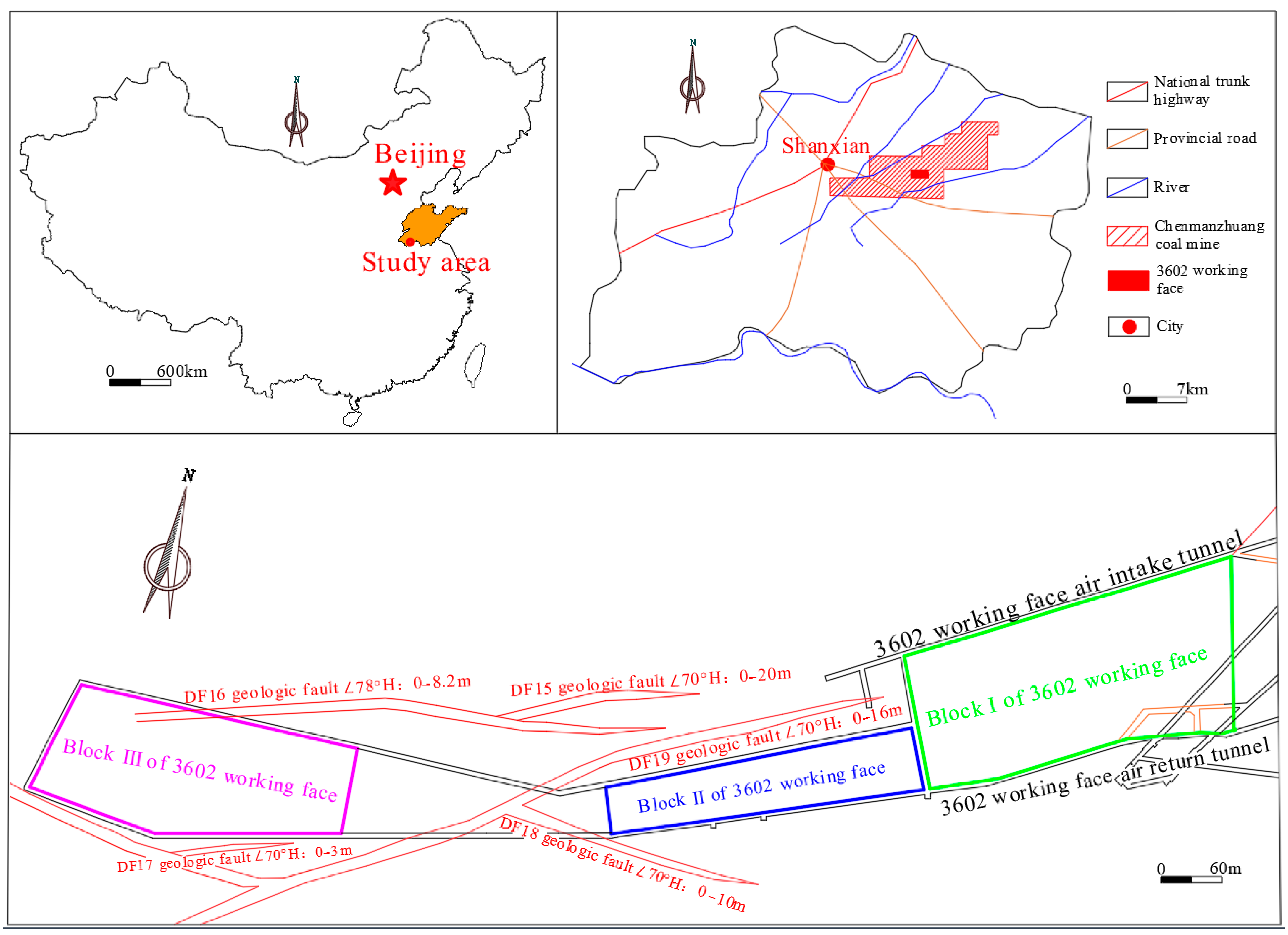
The Chenmanzhuang coal mine is located in the southeast of Shanxian County, approximately 15 km from the center. The shaft field extends about 11 km in the east–west direction and 2.2 km in the north–south direction, covering an area of 22.8371 km
2. The mine area is intersected by national and provincial highways, facilitating convenient transportation.
Figure 1 presents a schematic diagram of the 3602 working face of the Chenmanzhuang Mine, comprising three distinct block sections, I, II, and III. Each block section displays distinct geological structures and aquifer conditions. The geological arrangement of block section I is relatively simple, with the primary aquifers influencing mining operations, including the sandstone fissure aquifer of the floor plate, the No. 3 limestone aquifers of the floor plate, and the pore aquifer at the base of the loose layer. In blocks II and III, the geological configuration is more complex, and the thickness of the No. 3 limestone aquifers increases.
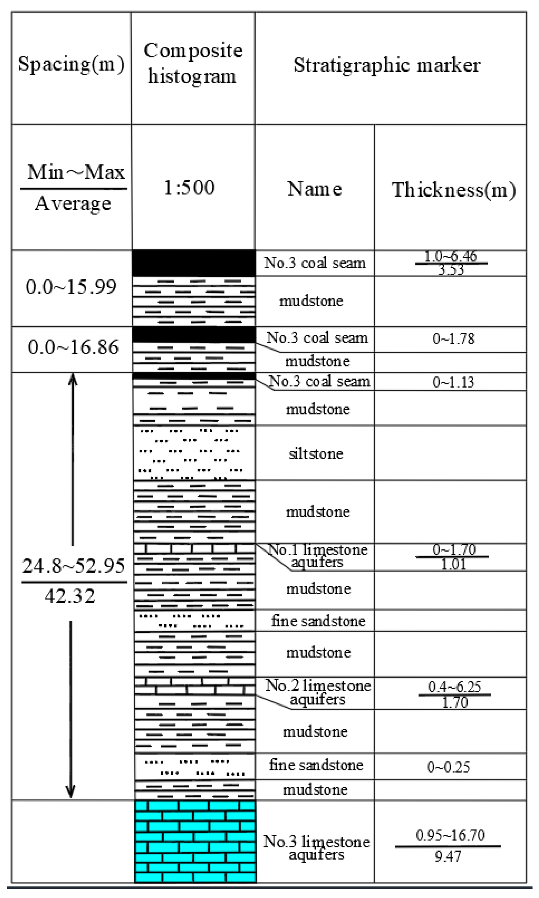
Figure 2 illustrates the composite histogram of the coal mine floor strata. This study will primarily focus on investigating blocks I and II, guided by the progress of physical exploration and the project objectives.
The coal seam mined at this face is part of the No. 3 seam of the Carboniferous-Diabase System of the Shanxi Group, with an elevation range from −640.0 to −776.7 m. The face has a strike length of 1250 m and a dip length ranging from 140 to 188 m. The dip angle of the seam ranges from 10 to 30 degrees, with an average of 20 degrees. The thickness of the coal seam ranges from 1.8 to 4.2 m, with an average thickness of 3.0 m. The working face primarily consists of a stable medium-thickness coal seam that is representative and exhibits both simple and complex conditions.
Coal Seam Roof and Floor Conditions
The top of the coal seam has a false roof of mudstone, averaging 1.5 m in thickness. Above it, the immediate roof, comprised of fine sandstone, is approximately 6.8 m thick and exhibits higher stability. The main roof, which consists of siltstone, has an average thickness of 8.2 m and demonstrates even greater stability. The immediate floor of the coal seam, also made of mudstone, is around 1.5 m thick but shows poor stability. During roadway excavation, special attention must be given to the immediate floor’s stability, necessitating appropriate support measures. In contrast, the main floor, made of fine sandstone, is considerably more stable. For additional details, refer to
Table 1. During coal seam mining, water inrush at the working face poses a threat to safe and efficient operations. Ensuring mining safety requires identifying the factors influencing coal seam water inrush and determining the safe and hazardous areas of the working face.
3. Introduction of PCA–RST
To improve the objectivity and accuracy of water inrush risk assessment, this study utilizes a method that integrates PCA–RST. This approach is employed to comprehensively analyze the geological conditions, hydrogeological features, mining processes, and other factors affecting the 3602 working face of the Chenmanzhuang Coal Mine. The goal is to create effective algorithms for assessing water inrush risks across multiple blocks within the working face. The technical approach is illustrated in
Figure 3.
3.1. Principal Component Analysis
PCA is a widely used technique for dimensionality reduction and is a linear combination of multiple variable indicators that exploits correlation among the variables to reduce their dimensionality and extract principal components. The primary advantage of PCA is that it reduces dimensionality while preserving essential information from the original data, allowing for the extraction of more insights from fewer principal components. The specific calculation can be performed using version 29 of the SPSS software.
This paper identifies six original evaluation indices based on the floor plate exploration data from the 3602 working face in the Chenmanzhuang coal mine. A specific schematic figure is shown in
Figure 4.
- (1)
Coal seam dip
Variations in coal seam dip affect the vertical displacement of the surrounding rock in the roadway and the extent of damage in the plastic zone. A larger coal seam dip angle increases the threat to roadway safety during mining and subjects the surrounding rock formation to greater stress. This condition can lead to increased aquifer recharge, resulting in enhanced water abundance in the rock formation.
- (2)
Height mining
The vertical stress on the advanced support of the working face decreases with increasing mining height, while the horizontal stress in the mined-out area increases. This change can lead to fractures in the surrounding rock of the coal seam, allowing aquifer water to potentially flow into the working face. In addition, the height of mining affects the stability of the coal wall, greater mining heights increasing the risk of coal wall spalling. Therefore, mining height is a crucial factor influencing the safety of the working face.
- (3)
Water pressure
Water pressure is a significant factor contributing to water inrush in coal mine floors. Confined water, under the influence of pressure, continually erodes and scours the impermeable layer beneath coal seam. This process facilitates infiltration into the overlying impermeable layer through structural fissure, which reduces the integrity of the impermeable layer, weakens the rock mass’s resistance strength, and expands the fissures within the impermeable layer. Ultimately, this leads to the formation of a water inrush channel.
- (4)
Water inflow
Mine water inflow serves as the primary criterion for mine design, production, drainage system configuration and the development of water control measures. As mining progresses, the mined-out area and the length of the pioneering roadway both increase, resulting in changes to the amount of mine water inflow.
- (5)
Aquiclude thickness
The aquiclude thickness of the coal seam floor is defined as the distance between the working face floor and the roof of the underlying aquifer. A greater aquiclude thickness correlates with a reduced likelihood of water inrush. Water inrush events in the coal seam floor occur only if the impermeable layer of the working face remains intact and the water pressure of the pressurized aquifer exceeds a critical threshold. Thus, aquiclude thickness serves as an important index for predicting water inrush.
- (6)
Thickness of exposed limestone
The thickness of exposed limestone is negatively correlated with water inrush. Limestone exhibits excellent cementing properties and is insoluble in water, providing a significant barrier to aquifer water. Consequently, increased limestone thickness enhances the stability of coal strata, thereby reducing the likelihood of sudden water influx [
21].
3.2. Rough Set Theory
RST, proposed by Pawlak [
22], is a framework for data analysis and processing. This theory is founded on a classification mechanism that utilizes equivalence relations to partition a specific space [
23]. RST conceptualizes knowledge as a division of data, and its core principle is to utilize a known knowledge base to refine imprecise or uncertain knowledge for further extension [
24]. A significant advantage of RST is its capacity to address and describe uncertainty in a relatively objective manner. This capability is realized by utilizing the inherent information in existing data and employing approximation operators, such as approximation space and upper and lower approximations of sets, to address vagueness and uncertainty without relying on auxiliary information or subjective judgment (such as the affiliation function in fuzzy set theory). These operators determine the correlation between data and indicators, facilitating data analysis [
25,
26,
27].
RST typically utilizes a collection of objects with multivalued attributes for data analysis. This mathematical theory examines imprecise and incomplete information, knowledge, and data. Unlike other approaches to addressing uncertainty and imprecision, RST does not require any a priori knowledge beyond the dataset. Instead, it relies on the dataset itself for decision-making, resulting in more objective descriptions and treatments of uncertainty. This trend has resulted in broader development prospects and successful applications in various fields [
28,
29,
30,
31]. In recent years, researchers have integrated rough sets with other mathematical methods to obtain more accurate and realistic evaluations of coal mines. For example, deep learning algorithms [
32], cloud models [
33] and fuzzy neural networks [
34] have been integrated with rough sets. These combinations facilitate the comprehensive utilization of each method’s advantages.
In the RST method, a correlation exists between knowledge and categories, with knowledge exhibiting a specific granularity. In this context, equivalence classes represent the granularity of knowledge. Knowledge granularity assesses the significance of equivalence classes and is indicated by the roughness of knowledge representation. RST seeks to analyze data through knowledge granularity, examine data structures using objective methods, and extract additional knowledge [
35]. The weight determination method is integrated with data mining to evaluate the significance of each indicator’s attributes and establish its corresponding weights. A known information set can be categorized into known decision attributes of the decision system and unknown decision attributes of the information system.
Thus, it is summarized by a decision system
, which is in turn realized by the description of the attributes of the object of study and their corresponding attribute values, i.e.,
, which is called a quaternion;
is the thesis domain, which denotes a nonempty finite set of the object of study
;
is called the set of attributes;
is a nonempty finite set of attributes, where
is the set of conditional attributes
;
is the set of decision attributes
;
denotes the domain of values of the attribute
, i.e.,
; and
denotes one of
‘s information function, i.e., for
,
, and usually
can also be abbreviated as
[
36,
37].
5. Mine Safety Evaluation Results
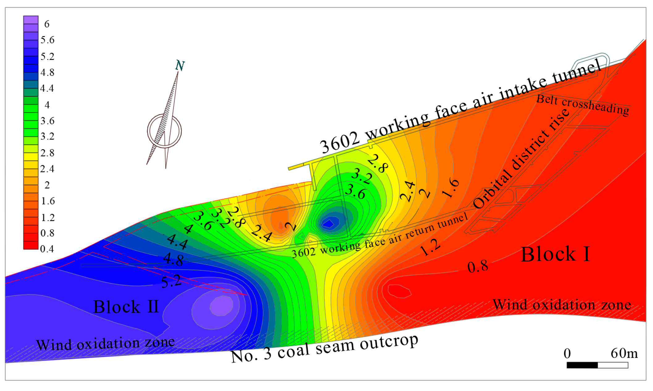
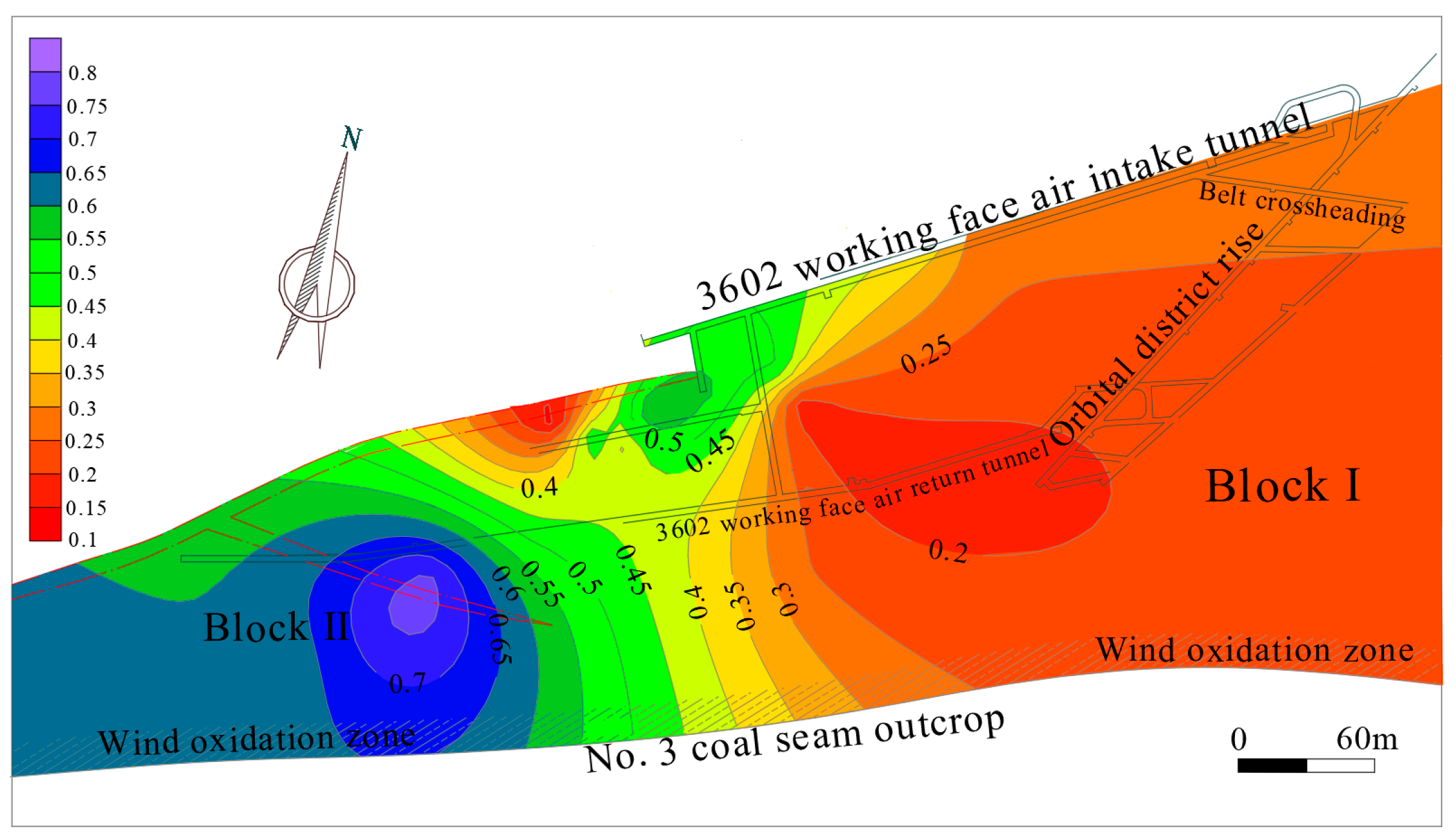
Based on the previously calculated weighting results, contour plots for water pressure and aquiclude thickness—two influential factors with larger weights—were generated using version 13 of the Surfer software, as illustrated in
Figure 5 and
Figure 6. This visualization enhances the understanding of the water inrush distribution and its trends in the working face. The contour plots indicate that water pressure in the working face gradually increases from east to west, with a maximum of 5.6 MPa and a minimum of 0.8 MPa, highlighting a significant difference. Additionally, from the analysis of the ground drilling No. 3 limestone aquifer pumping test data in the 3602 working face (block section I), it can be concluded that the No. 3 limestone aquifer of the floor of block section I of the 3602 working face is not homogeneous in nature. Therefore, to ensure the safe mining of the block section I of the working face, it is essential to control the water pressure and volume in each area within the safe range. The analysis of the downhole drilling exploration data indicates that the thickness of the No. 3 limestone aquifer in the floor plate of the 3602 working face gradually increases from block section I to block section II, while the thickness of the No. 3 limestone aquiclude in the coal seam floor plate gradually decreases. In addition, block section II is affected by faults, leading to the development of local fissures that create conditions conducive to water abundance anomalies in this area. Consequently, it is essential to closely monitor changes in water pressure and aquiclude thickness at this working face, while controlling the degree of change within a reasonable range.
Following the calculation of index weights using RST, the standardized data were weighted using the linear weighted sum method, resulting in 19 sets of the comprehensive evaluation value S. The specific results are presented in
Table 9.
To better observe the impact of the combined effect of the four main influencing factors on the working face, a contour map was created to classify the water inrush hazard areas based on the 19 groups of composite evaluation values derived above. The overall range of the composite values spans from 0 to 1, with areas closer to 1 indicating higher danger.
Figure 7 illustrates that the comprehensive evaluation value for the western part of the working face is higher and closest to 1, indicating that this area is most hazardous for water inrush. In contrast, the values decrease further east, indicating increased safety.
Figure 8 is the contour map of the water inrush coefficient. When the water inrush coefficient is greater than 0.06, this means that the water inrush danger in the area is larger, as can be seen in
Figure 8; the value for the western area is still greater than 0.06, and the maximum value is as high as 0.1, which belongs in the danger zone for water inrush, and the eastern part is safer. However, in the middle of the I and II block section junction, there is still a small part of the 0.06 critical value of the region, indicating that the region theoretically also exists with the possibility of water inrush, but the field exploration report data show that there is no threat of water inrush in the central region, and only the western region is confirmed to be a danger zone, which also verifies the accuracy of
Figure 7. For the situation in which there is a critical value in the middle area of
Figure 8, the reason may be that the water inrush coefficient method only takes into account the influence of two factors: water pressure and the aquiclude thickness, and ignores the sensitivity of other factors, which leads to the derived results not being as accurate as the comprehensive evaluation value. In summary, the western area of the Chenmanzhuang Coal Mine’s 3602 working face presents a significant risk of water inrush, necessitating attention and preventative measures. In contrast, the eastern area is relatively safe, exhibiting a low probability of water inrush, thereby permitting safe mining operations.
To mitigate the potential danger of water inrush in coal mines, this paper proposes several recommendations aimed at preventing and controlling water inrush. First, it is crucial to pay attention to hazardous water inrush areas and install water level monitoring instruments and pressure sensors at an early stage. Regular monitoring of water pressure and water level changes around the working face is necessary. Additionally, strengthening hydrogeological investigations, identifying anomalous situations in a timely manner, and taking appropriate measures to adjust and respond are key. Second, it is essential to establish and maintain an effective drainage system to ensure smooth drainage of the working face and the surrounding area. Appropriate pumping measures should be taken to reduce the groundwater level and minimize the risk of water inrush. Third, if needed, reinforcement work should be carried out for the impermeable layer, such as the use of grouting technology to enhance its impermeability and reduce the likelihood of water inrush. Fourth, a comprehensive safety management system and operating procedures should be formulated to ensure that personnel strictly adhere to regulations. Enhanced safety training is necessary to improve staff’s ability to cope with emergencies and increase safety awareness. Finally, a perfect emergency plan should be formulated for emergency situations, including emergency treatment processes for water inrush and evacuation, and rescue measures, to ensure prompt and effective responses in the event of emergencies. This will improve the safety of the working face and guarantee safe and orderly mining operations.
All in all, in order to assess the degree of model response to changes in input parameters, a sensitivity analysis was conducted in this study. We first used principal component analysis (PCA) to reduce the dimensionality of the original influencing factors for the 3602 working face in Chenmanzhuang coal mine, and identified four main influencing factors: water pressure, water inflow, aquiclude thickness, and exposed limestone thickness. Subsequently, the random sampling technique (RST) was applied to calculate the weights of these four main influencing factors on the water inrush, and the results were 0.36, 0.2, 0.24, and 0.2, respectively. These results clearly show the sensitivity of each factor of the water inrush, especially the most significant effect of water pressure. Through this sensitivity analysis, we are able to clearly identify which parameters play a key role in the model, which provides an important basis for subsequent research and engineering decision-making.


