Article

Feasibility of Groundwater Extraction in Nitrate-Impacted Groundwater Source in Serbia: Hydrodynamic Modeling and Nitrate Tracing

by
Marija Perović
*,
Vesna Zuber-Radenković
and
Miloš Zorić
Jaroslav Černi Water Institute, 80 Jaroslava Černog St., 11226 Belgrade, Serbia
*
Author to whom correspondence should be addressed.
Water 2024, 16(15), 2105; https://doi.org/10.3390/w16152105
Submission received: 18 June 2024 / Revised: 17 July 2024 / Accepted: 18 July 2024 / Published: 25 July 2024

Abstract

:
Groundwater, essential for supplying drinking water to half of the global population and supporting nearly half of all irrigation needs, faces significant contamination risks. These risks pose serious threats to human health and ecosystem integrity, driven by increasing pressures from both concentrated and diffuse pollution sources, as well as from growing exploitation. The presented research was conducted with the dual objectives of identifying sources of nitrate contamination (up to 128.1 mg/L) in an oxic groundwater source (Perkićevo, Serbia) and proposing an optimal extraction regimen to ensure a sufficient supply of potable water. Correlations between chemical elements’ concentrations and principal component analysis (PCA) indicated a significant relationship between anthropogenic impact indicators (NO3, Na+, B, Cl, SO42−, KMnO4 consumption, and electroconductivity), unambiguously showing that groundwater quality was primarily impacted by untreated sewage inflow and confirming nitrate’s tracer behavior in oxic environments. The spatial distribution of selected parameter concentration gradients highlighted the expansion and distribution of the contamination front. A numerical groundwater flow model (Vistas 4 and Modflow) was applied to determine the groundwater flow direction and the quantity of groundwater originating from different parts of the investigated area. Through four simulated groundwater extraction scenarios, Scenario 2, with an average extraction rate of 80 L/s from 12 wells, and Scenario 3, with an average extraction rate of 75 L/s and 4 additional wells, were identified as the most optimal, providing a sufficient quantity of adequately sanitary water.

1. Introduction

The widespread contamination of groundwater with nitrates highlights the critical necessity for a comprehensive evaluation of effective mitigation measures, particularly given the health implications and substantial costs associated with remediation efforts. The International Agency for Research on Cancer (IARC) classifies nitrates and nitrites as Group 2A (vol. 94), labelling them as probably carcinogenic to humans, which under certain conditions may lead to the formation of known carcinogens such as N-nitroso compounds [1]. Methemoglobinemia, a hematological disorder where red blood cells contain over 1% methemoglobin, which cannot effectively bind oxygen, leads to hypoxia and is enabled in the presence of nitrites. Eutrophication is the natural response of aquatic ecosystems to increased levels of nitrate and phosphate salts, resulting in elevated primary production and aquatic plant growth. Increased plant growth leads to higher organic matter content, which decomposes bacterially, producing unpleasant odors, consuming available oxygen, and affecting the development of other aquatic organisms. Therefore, implementing sustainable groundwater management practices is essential to safeguard public health and preserve environmental integrity. In most cases, the presence of nitrates in groundwater indicates the presence of viruses, bacteria, and protozoa, as the most common nitrogen sources are untreated sewage and fertilizer/manure application. It is generally accepted that concentrations of nitrate nitrogen in water above 1 or 3 mgN/L [2,3] and ammonium ions above 0.2 mgN/L [4] represent an anthropogenic influence.
Intensive agricultural production, fertilizer and manure application, unsanitary landfilling, or unregulated sewage discharges can significantly contribute to groundwater nitrate contamination [5,6,7]. The most nitrate-vulnerable groundwaters are those within shallow aquifers with highly permeable top layers, typically found in intergranular and fractured karst aquifers. These aquifers often contain significant concentrations of dissolved oxygen, which keeps nitrogen in its most oxidative state, N+5 (NO3) [8]. Given nitrogen’s wide range of oxidation states (from −3 to +5), its ionic behavior can vary depending on the prevailing conditions [8]. This most oxidized form of nitrogen is characterized by its inability to sorb onto negatively charged sediment particles, resulting in nearly tracer-like movement in oxic water. Groundwater is considered oxic if the dissolved oxygen content is above 1 mg/L, while significant nitrate reduction is not expected at dissolved oxygen concentrations above 2 mg/L [9]. Depending on the oxygen content, redox conditions, and availability of electron donors, nitrogen compounds entering groundwater undergo complex dynamics involving various biogeochemical processes within the nitrogen cycle: denitrification (DN), dissimilatory and/or assimilatory reduction to ammonium ions (DNRA, ANRA), nitrification, anaerobic ammonium oxidation (Anammox, Feammox), nitrifying denitrification, sorption, and organic matter mineralization [10,11]. The nitrate reductive transformations will start to unfold in the conditions of decreased oxygen content in the presence of different electron donors (depending on the aquifer strata composition). The highest redox values at which nitrate reduction can be expected are around 150 mV (<250 mV). Defining the boundaries of redox zones can only be considered approximate due to the possibility of simultaneous reduction processes of different electron acceptors occurring in microniches or in mixing zones of water with different origins, ages, and redox fronts [9,12]. The mechanisms of nitrate transformation under varying conditions have been well studied and documented [13,14,15].
In oxygen-rich groundwater, closely tracking the variations in nitrate co-migrants’ concentrations could provide valuable insight for accurately identifying the source of nitrate contamination. Concurrent tracking of B concentration levels [11,16], Cl [17], and Na+ [18] can be utilized for detecting anthropogenic influences (such as untreated sewage inflow and fertilizer/manure application). Simultaneous elevated concentrations of B and NH4+ may indicate their common origin from sewage or wastewater [19]. One of the most common anthropogenic uses of boron and sodium compounds is in the production of sodium perborate (NaBO3·nH2O), frequently employed in bleach, detergents, soaps, and toothpaste additives. Inactive fillers, such as sodium sulfate for powdered detergents, sodium sulfate and sodium chloride for soaps, and sodium and potassium chloride with sodium sulfate as thickeners in shampoos [20], correlate with boron in water, indicating an anthropogenic influence. Boron is considered a nitrate co-migrant and remains inert during redox changes in processes such as nitrification, denitrification, and transport. High boron concentrations accompanied by low NO3 levels likely indicate a detergent influence, while moderate boron concentrations alongside moderate NO3 levels probably suggest the influx of wastewater effluents [21]. Ammonium cations (NH4+) naturally arise from the anaerobic degradation of organic matter, while anthropogenic sources include the disposal of organic wastes such as manure, sewage, and septic tanks. Aquifers contaminated by landfill leachate or wastewater disposal exhibit notably high NH4+ concentrations, often ranging from 14 to 140 mg/L [22]. Elevated NH4+ levels can also result from improper nitrogen fertilizer application, influenced by factors such as quantity, meteorological conditions, fertilizer types, and soil characteristics, as well as the presence of septic tanks [22]. Additionally, natural NH4+ concentrations, reaching up to 3 mg/L, have been documented in layers abundant in humic materials, iron cations, or in aquifers beneath forest ecosystems [19].
The European approach to the nitrate issue recognizes the need for integrated protection and management of water resources. The European Union and the World Health Organization (WHO) have set a limit for nitrate concentration in drinking water at 11.3 mgN/L (50 mgNO3/L), while the United States Environmental Protection Agency (USEPA) has established a drinking water standard of 10 mgN/L (45 mgNO3/L) [23]. The Nitrate Directive [24] mandates the protection of all natural freshwater bodies and sets a limit of 50 mgNO3/L, which applies to all groundwater regardless of its intended use. In Serbia, 75% of potable water comes from groundwater, with 50% of this sourced from alluvial aquifers, which are predominantly characterized by intergranular porosity.
Current research on the origins of nitrates has primarily concentrated on aquifers beneath agricultural lands [25]. It has been demonstrated that urbanized areas in southern China exhibit significantly higher concentrations of nitrates and ammonium in groundwater compared to non-urbanized areas, often exceeding or reaching twice the levels found in the latter [25]. The fate of nitrogen fertilizer and nitrate transport were investigated in the Seine basin in France [26]. Peak nitrate concentrations were found in shallow, oxygen-rich groundwater beneath agricultural areas with well-drained soil, contrasting with lower concentrations observed in deeper, reduced groundwater zones across the United States [27]. Nitrate levels were investigated in the principal aquifers of England and Wales, and widespread increases in nitrate concentrations were discovered and accompanied by limited denitrification, primarily occurring in confined, oxygen-depleted zones [28]. In recent years, multivariate statistical methods have emerged as widely utilized tools for identifying the sources of nitrogen compounds in groundwater [8,9,15,25,29]. Principal component analysis (PCA) as a statistical technique used for dimensionality reduction and data visualization transformed the original variables into a new set of uncorrelated variables called principal components (PCs). PCs represent combinations of the original variables that capture the most variance in the data, with the extracted PCs ordered by the amount of variance they explain [5]. Calculated loadings measured the strength of the relationship between two continuous variables [5]. PCA elucidates the origins and relationships among chemical components, aiding in the interpretation of factors influencing water chemistry and in grouping sampled sites based on similarities [8,9,30]. In this study, we utilized PCA to uncover hidden patterns among physicochemical parameters, coupled with hydrodynamic calculations to identify optimal groundwater extraction scenarios. This approach helped determine the origins of nitrates and optimize the utilization of groundwater sources in terms of both quality and quantity. Statistical data processing encompassing PCA and calculation of Pearson’s linear coefficients was applied for a set of parameters including pH, KMnO4 consumption, Cl, NO3, electrochemical conductivity (Ec), SO42−, Na+, B, and dissolved oxygen (DO).
The shutdown of a groundwater source due to increased nitrate levels triggered the start of the presented research, which encompassed hydrogeological analysis (to determine the characteristics of the exploited aquifer) followed by detailed physicochemical examinations of groundwater and surface water quality. The examined shallow oxic aquifer lies beneath areas used for agricultural production and an urban settlement where connection to the sanitary sewer system is partial. This comprehensive study had two main objectives: to determine the sources of nitrates whose elevated concentrations caused the shutdown of the water source and to identify the best optimized utilization scenario of groundwater sources in terms of both quality and quantity. Examined scenarios considered the influence of the identified nitrate source, observed quality variations, and projected population growth. To achieve the set objectives, targeted monitoring, including that for groundwater flow, physicochemical quality, surface water quality, and river level data, was conducted.
Many researchers employ modeling tools like Vistas, Modflow, and Modpath to analyze groundwater flow and nitrate contamination, simulating their dynamics and fates over multiple time periods [31,32,33,34,35,36,37]. Groundwater Vistas (Modflow) was utilized for determination of groundwater flow and aquifer response to various utilization stresses, such as pumping and recharge. This included assessment and quantification of groundwater recharge and discharge areas, as well as adjusting model parameters to align with observed data and assessing model sensitivity to parameter changes. The application of hydrodynamic modeling proves highly beneficial in evaluating diverse management scenarios and future conditions to facilitate informed decision-making in water resource management. Furthermore, visualization techniques are employed to illustrate groundwater flow paths, aiding in the understanding of subsurface flow dynamics.
Four scenarios of different groundwater extraction rates were analyzed to indicate the most optimal extraction rate to fulfill the anticipated increase in demand while meeting the required groundwater quality standards: Scenario 1—existing state, average annual exploitation rate of Q = 55 L/s, with 12 existing wells (in Zone 1); Scenario 2—existing state with maximum exploitation rate of Q = 80 L/s for a duration of three months during the dry period, with 12 existing wells (in Zone 1); Scenario 3—expansion of the water source to Zone 2 with an average annual exploitation rate of Q = 75 L/s, with 12 existing wells and 4 new wells in Zone 2 (recommended source expansion—future state); and Scenario 4—expansion of the water source to Zones 2 and 3 with an average annual exploitation rate of Q = 105 L/s, with 12 existing wells, 4 new wells in Zone 2, and 6 new wells in Zone 3 (potential source expansion—future state). The presented investigation began as part of a study for the Groundwater Reserves Report. Subsequent physicochemical analyses were conducted concurrently with the primary measurements to understand the reasons for nitrate presence and the shutdown of the water source. Additional research efforts are necessary to expand and enhance the investigation, given the current lack of further information regarding the water source.

2. Materials and Methods

2.1. Investigated Site

Svilajnac Municipality, in Central Serbia’s Pomoravlje District, lies about 110 km southeast of Belgrade, covering the right bank of the Velika Morava River and traversing the Resava River. The Perkićevo groundwater source, part of Svilajnac’s water supply system, is located on the northern outskirts of the town at the boundary between urban and agricultural areas (Figure 1). It taps a shallow aquifer of the gravelly–sandy alluvium of the Velika Morava and Resava rivers by 16 artesian wells, out of which 12 are in operation. The groundwater source has been in use for over 40 years. At the time of this research, Perkićevo supplied water, treated only with chlorination, to about 14,000 residents in Svilajnac, Lukovica, Kušiljevo, and Crkvenac. The average annual production is around 55 L/s. Svilajnac, along with its infrastructure, is primarily situated upstream south and west of the water source, with most households connected to the sewage system. Agricultural land is located north and east of the source, with various crops grown, predominantly corn and wheat. The typical nitrogen application rate, primarily through mineral fertilizers such as urea, monoammonium phosphate (MAP), and calcium ammonium nitrate (CAN), is approximately 155 kgN/ha, which roughly matches the quantity of nitrogen applied through mineral fertilizers [15]. Additionally, manure is utilized in this region, although specific application amounts were not provided [15]. Construction of the sewage system in Svilajnac commenced in the 1970s. The current system serves Svilajnac and Lukovica, with over 90% completion of the sewage network. This setup comprises four pumping stations, facilitating the transportation of wastewater from the central station via a 300 mm pressure pipeline to the two lagoons. Treatment involves aeration and sedimentation. The lagoon structures are not composed of solid materials. Within the lagoons, sedimentation takes place, followed by the discharge of treated wastewater into the Resava River, downstream from the groundwater source, as well as the municipal waste landfill. This landfill receives mixed waste from diverse sources, operates without regulation, and lacks necessary infrastructure or protective measures. In the Municipality of Svilajnac’s Spatial Plan, potential groundwater and surface water pollutants are identified, including agricultural activities (attributed to the uncontrolled use of pesticides), the unregulated sewage network, farms (associated with uncontrolled wastewater discharge), and non-sanitary landfills.

Hydrogeological Characteristics

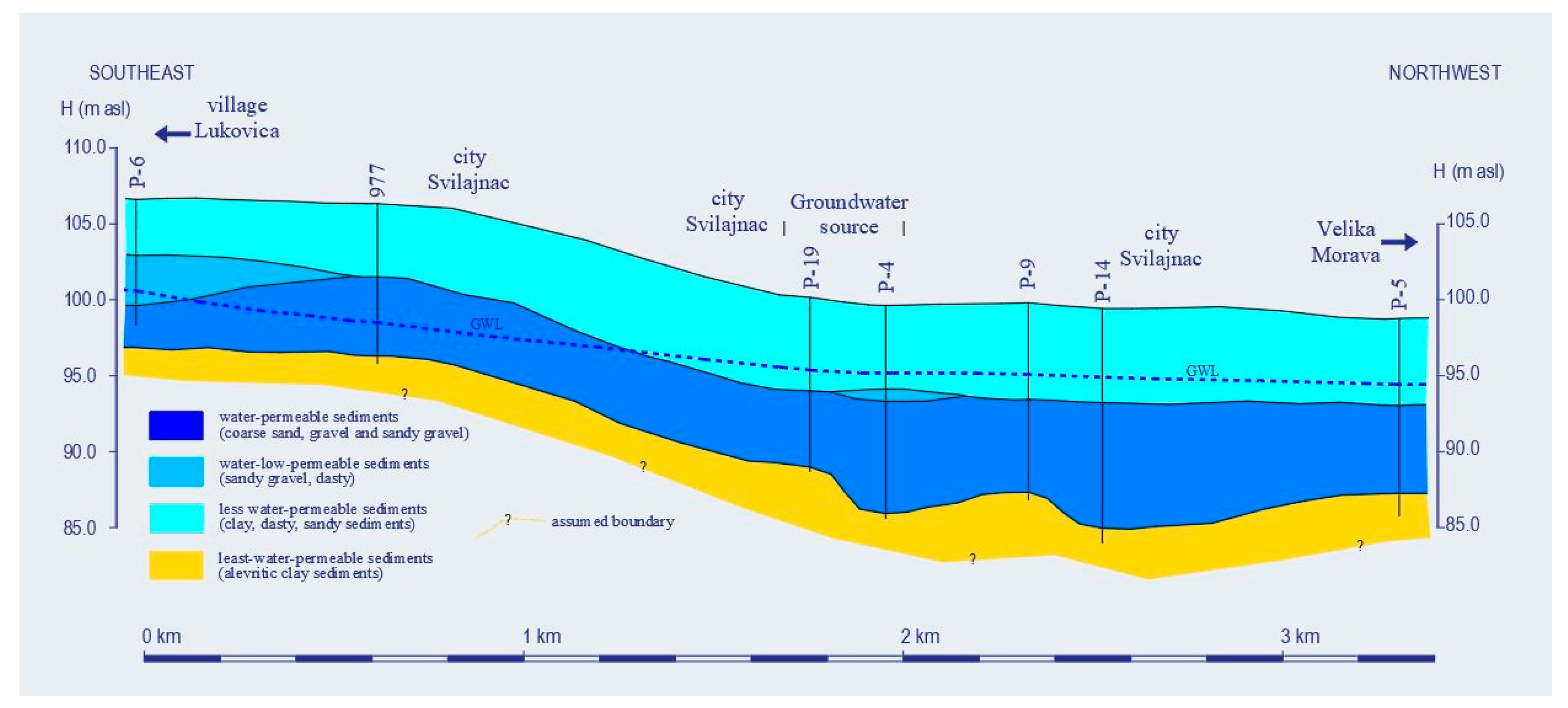
The study area comprises the alluvial plain of the Velika Morava and Resava rivers, with terrain elevations ranging from approximately 98 to 105 m above sea level (m a.s.l.). The aquifer is formed in gravelly–sandy quaternary sediments with some silty zones, as well as occasional sands and sandy loams, characterized by intergranular porosity (Figure 2). The gravel fraction features a variety of pebble sizes ranging from 1 to 5 cm. The aquifer has good permeability and continuous distribution within the alluvial plain area. The aquifer is under pressure, partly with a free water level, and hydraulically connected to the Velika Morava and Resava rivers. Depending on hydrological conditions, the rivers serve as a main source of recharge or discharge for groundwater. The top layer consists of humus–clayey and clayey–silty sediments, while blue marly clays are predominant in the subsoil. The less permeable surface layer partially prevents and retards the infiltration of surface pollutants into the groundwater. The thickness of the water-bearing layer ranges from 3 m (mainly sands, partially gravel, in the Lukovica area) to 8.5 m. In the groundwater source area, the average thickness is about 5.5 m. The average thickness of the top layer in the groundwater source area is 7 m (Figure 2). The filtration coefficient of the gravelly–sandy aquifer is in range of K = 10−2–100 cm/s, while the clayey–alluvium in top layer has filtration coefficient values on the order of magnitude of K = 10−6–10−7 cm/s. The filtration coefficient values of the bottom layers are on the order of magnitude of K = 10−4–10−6 cm/s. The piezometric level is 3 to 6 m under the terrain surface, within the 94 to 97 m a.s.l. The oscillation regimen of piezometric levels is predominantly influenced by the fluctuations in the water levels of the Velika Morava and Resava rivers, as well as the exploitation regimen at the Perkićevo source. The general direction of groundwater flow is southeast–northwest.

2.2. Hydrogeological Modeling

The licensed software Groundwater Vistas 4.0, developed by Environmental Simulations, Inc., Leesport, PA, USA, was used for hydrodynamic calculations, data input, and result interpretation. Modflow, employing finite difference numerical methods, facilitated the calculations, solving systems of differential equations pertaining to groundwater flow. These calculations, along with an assessment of other key balance elements, were utilized to assess four different scenarios to determine the most sustainable utilization of the Perkićevo groundwater source in terms of quality and quantity.

Development and Calibration of a Hydrodynamic Model

The hydrodynamic model of the alluvial plain encompasses two main components: a highly permeable gravel–sandy aquifer complex, marked by intergranular porosity, which serves as the source of the Perkićevo spring that supplies water to Svilajnac; and an overlying semi-permeable complex consisting of clay, silt, and sand, which facilitates vertical filtration of water from the surface to the aquifer below.
The model encompasses the wider vicinity of the Perkićevo water source, covering an approximate surface area of 32 km2. The model’s eastern boundary extends along the hills on the right bank of the Resava River, reaching approximately 5 km. On the western side, it covers a section of the alluvial plain along the left bank of the Velika Morava River for about 5 km. Moving northward, the boundary intersects the Morava alluvial plain for around 7 km, starting approximately 1.5 km downstream from the confluence of the Resava River. To the south, the boundary intersects both the Morava and Resava alluvial plains for approximately 7 km, covering an area of about 3 km upstream from the confluence of the Resava River, situated south of Svilajnac. The shallow alluvial aquifer is partly confined. The aquifer’s geometry is modeled based on exploratory drilling data from various research conducted in the past. Schematized layers within the active part of the model have a continuous distribution. Terrain elevations in the alluvial plain range from 97 to 108 m above sea level. The elevations of the first layer range from 87 to 102 m a.s.l., while those of the second layer range from 83 to 98 m a.s.l. The grid in this model has a resolution of 100 m by 100 m, with a finer discretization of 50 m by 50 m in the area of the exploitation wells. The model dimensions are 6.9 km in the x-direction and 4.6 km in the y-direction, covering an area of 31.74 km2. This results in 7488 grid cells, of which 6966 are active. Initial values for hydraulic conductivity were determined based on previous years of research from various projects. These included model tests, data processing from well pumping tests, and laboratory tests of the mechanical and filtration characteristics of sediment samples. These values were subsequently adjusted during the calibration procedure. The adopted values are as follows: Layer 1: low-permeability sediments, filtration coefficient k = 1 × 10⁻⁷ m/s (or k = 8.64 × 10⁻³ m/day); Layer 2: aquifer in the river terraces area, k = 1.74 × 10⁻³ m/s (or k = 150 m/day); aquifers in the alluvial plain of Velika Morava and Resava, k = 2.2 × 10⁻³ m/s (or k = 190 m/day) and k = 3.5 × 10⁻⁵ m/s (or k = 3 m/day); and the transition zone, k = 4 × 10⁻⁴ m/s (or k = 35 m/day). Based on the data from the well pumping test at the Perkićevo source, it was concluded that the aquifer has excellent filtration characteristics. The obtained transmissivity values ranged from 18 × 10−3 to 97 × 10−3 m2/s, with a representative value of T = 30 × 10−3 m2/s that was determined through model tests for the narrower zone of the source. The description of the hydrogeological characteristics aligns with the high hydraulic conductivity values observed in the aquifer. At the edge of the alluvial plain, the hydraulic conductivity is k = 3.5 × 10⁻⁵ m/s. Representative values of the filtration coefficient were obtained through the model calibration procedure under steady-state flow conditions.
Boundary conditions can generally be classified into three categories: boundary conditions with specified (defined) values of the piezometric level, often referred to as first-type boundary conditions or Neumann conditions (H = Const.); boundary conditions with specified flow rates, also known as second-type boundary conditions or Dirichlet conditions (Q = const.); and third-type boundary conditions, known as Cauchy conditions. The basis for setting the values are the results of previous modeling experiments and observation data of piezometric levels in the analyzed period. The boundary condition with a specified flow rate was set in the area of the Perkićevo source in Layer 2 in fields where production wells are located to extract water from the alluvial aquifer. During the calibration process under steady-state conditions, the constant head boundary condition (where H remains constant along the specified path) was applied in the model. The values were assigned based on results from previous model tests and observational data from piezometer levels recorded during the analyzed period. This boundary condition applies specifically to Layer 2. The boundary condition Q = Const. was applied to maintain constant flow in the wells. Initially, during the calibrated period, there were 12 wells in operation at the source. Looking ahead, the hydrodynamic model analysis involved adding another 10 new wells: 4 in Zone 2 and 6 in Zone 3. The river boundary condition was applied where the Velika Morava and Resava rivers intersect, significantly influencing the dynamics of the alluvial aquifer in Layer 2. These rivers have carved their beds into the water-bearing middle of the alluvium, establishing hydraulic connections with the aquifer. Recharge was estimated at approximately 20% of the precipitation, calculated based on data from three meteorological stations at similar altitudes. The representative parameters of the aquifer were determined from systematic observations and monitoring of changes in hydrological elements, such as fluctuations in piezometric levels (Table 1).
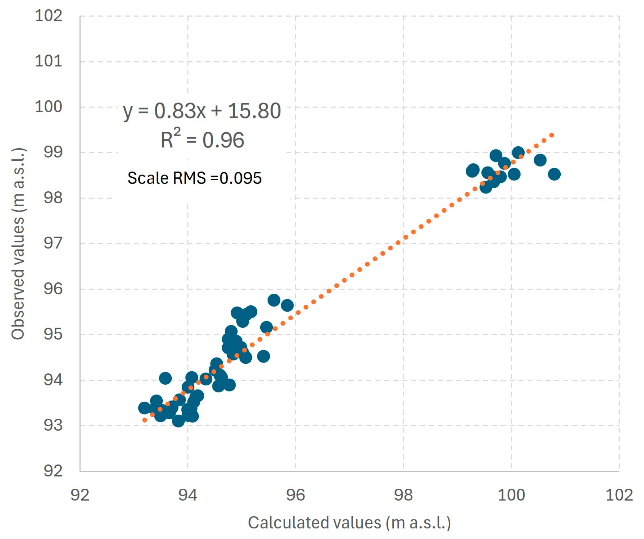
The model calibration was assessed using the coefficient of determination (R2) and scaled RMSE criteria (Equation (1)). The RMSE value is generated by Vistas based on the measured and calculated values and a weight value (ranging from 0 to 1) assigned by the modeler. A larger difference between the calculated and observed values results in a higher RMSE, and vice versa. Additionally, a weight value (from 0 to 1) is assigned to observation wells depending on the amount of data available for the piezometer and the distance. After calibration, the observed and calculated water levels closely matched along the 1:1 line, with an R2 exceeding 0.9, thus meeting the criteria for ‘acceptable calibration’. Furthermore, the scaled RMSE was below 10% (Figure 3).
R M S E = 1 h t = n + 1 n + h y t y ` t 2 1 n 1 t = 2 n y t y t 1 2
where y is the observed value; y` is the calculated value; n is the number of observed values; h is the number of calculated values, and t stands for time.
The model, incorporating representative geometric, hydrogeological, and hydrodynamic characteristics, satisfactorily matches the data derived from calculations and field measurements. It has been validated for further calculations and forecasting.

2.3. Water Quality

2.3.1. Groundwater Quality

Groundwater was analyzed based on exactly 200 samples, encompassing three different datasets. The first set comprised samples from domestic wells (T1–T38), with 37 samples collected during 2011; the second set comprised 50 samples (C1–C21) from a broader area collected between 2011 and 2013; and the third set included groundwater from Perkićevo source wells (B1–B13), with 113 samples collected between 2002 and 2011.
The monitored parameters that were obtained are as follows: pH, KMnO4, NH4+, Cl, NO2, NO3, electrochemical conductivity (Ec), Fetot, Mntot, SO42−, Na, B, and dissolved oxygen (DO). The pH, DO, and Ec were measured in situ using a WTW 197i multiparameter probe (WTW, Weilheim, Germany). The probe was calibrated on-site and then lowered to the screen level for measurements. Bailers and submersible pumps were used to extract the water samples. Glass bottles with samples were immediately capped with no head space. NO3 NH4+, NO2, and Fe2+ were quantified by the spectrophotometric method. SO42− was determined by a turbidimeter (WTW TURB 430IR, WTW, Weilheim, Germany). The volumetric method was applied for Cl and KMnO4 analyses. For total Fe, Mn, Na, and B analyses, Inductively Coupled Plasma (Spectra Genesis ICP instrument, Kleve, Germany) was utilized. Chemical analyses were performed in accordance with the procedures detailed in APHA, 2005. Quality assurance and control measures were implemented during sampling and analysis following the ISO 17025 standards for the competence of testing and calibration laboratories [38]. Samples were collected in triplicate.
Groundwater quality data were statistically processed using IBM SPSS v23. QGIS Desktop 3.32.1 Lima and Thin plate spline interpolation enabled visual presentation of the spatial distribution of selected concentration gradients.

2.3.2. Surface Water Quality

A comprehensive investigation of water quality was undertaken, involving the analysis of samples collected from the surface waters of both the Velika Morava and Resava rivers. Official state monitoring encompassed the location of interest only during the periods of 2001 to 2004 for the Velika Morava River at the Velika Plana profile, comprising 42 samples, and from 2001 to 2006 for the Resava River at the Svilajnac profile, comprising 67 samples.
The research has certain limitations, including restricted data availability and conclusions that are specific to a particular hydrogeological setting with oxic conditions, shallow groundwater, and a semi-confined aquifer. Certain challenges are also related to the three data sets, which each with different parameter extents (as shown in Table S1 of the Supplementary Material).

3. Results

3.1. Modeling Results

The study evaluated four scenarios to determine the optimal groundwater extraction rate that balances anticipated demand growth with adherence to groundwater quality standards: Scenario 1: current conditions, with an average annual extraction rate of Q = 55 L/s from 12 existing wells in Zone 1; Scenario 2: current conditions, allowing for a maximum extraction rate of Q = 80 L/s during a three-month dry season period, using 12 existing wells in Zone 1; Scenario 3: expansion to Zone 2, maintaining an average annual extraction rate of Q = 75 L/s, utilizing 12 existing wells and adding 4 new wells in Zone 2 (recommended future expansion); and Scenario 4: expansion to Zones 2 and 3, with an average annual extraction rate of Q = 105 L/s, using 12 existing wells and adding 4 new wells in Zone 2 and 6 new wells in Zone 3 (potential future expansion).

3.1.1. Scenario 1—Existing State, Average Annual Exploitation Rate of Q = 55 L/s, with 12 Existing Wells (in Zone 1)

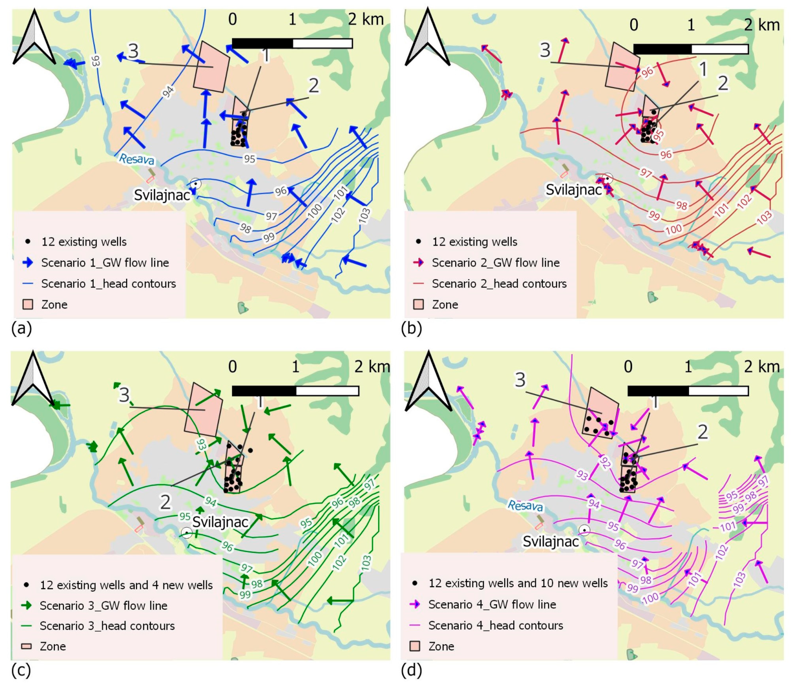
During the calculation for the analysis of the alluvial aquifer balance, it was revealed that the predominant flow direction is southeast–northwest, with the recharge coming from the direction of the Resava River, specifically beneath the area of the town of Svilajnac. Based on the hydrodynamic calculations, under existing conditions with an average extraction rate at the Perkićevo source of 55 L/s, it was determined that approximately 43 L/s (about 80% of the total abstracted water at the source) reaches the source area from the direction of the Resava River, beneath the urban area. From the direction of Lukovica (southeast), approximately 8 L/s (about 15% of the total abstracted water at the source) reaches the source area, and from the north and northeast directions, approximately 4 L/s contributes to the source area. A depression funnel is formed in the source area with piezometric levels around 93.5–94.5 m a.s.l. (the aquifer is under pressure) (Figure 4a).
The areas of similar nitrate content in groundwater are isolated and the average value is calculated for each of them, and simultaneously, the flow from these areas to the source area is calculated on the model. Under these conditions and this exploitation regimen, the expected nitrate content in the composite water of the source is around 41–42 mg/L. This condition is subject to seasonal changes depending on the hydrological conditions, extraction intensity, and changes in nitrate content in groundwater across the area.

3.1.2. Scenario 2—Existing State with Maximum Exploitation Rate of Q = 80 L/s for a Duration of Three Months during the Dry Period, with 12 Existing Wells (in Zone 1)

Similar conditions occur under the exploitation conditions at the source of 80 L/s, which represents the capacity of the source and the maximum daily quantity of water that the source can provide during periods of increased water demand (usually lasting for a few months during the dry period). Under such extreme hydrological and operational conditions, a depression funnel would form in the source area, with piezometric levels reaching a minimum of around 91.5–92.5 m a.s.l. Despite this, the aquifer in the source area remains under pressure, meaning that the levels will not drop below the aquifer base (Figure 4b). Based on the hydrodynamic calculations, under existing conditions with an average extraction rate of 80 L/s, it was determined that approximately 65 L/s (about 81% of the total abstracted water at the source) reaches the source area from the direction of the Resava River, beneath the urban area. From the direction of Lukovica (southeast), approximately 9 L/s (about 11% of the total abstracted water at the source) reaches the source area, and from the north and northeast directions, approximately 6 L/s contributes to the source area (about 8% of the total abstracted water at the source) (Figure 4b).

3.1.3. Scenario 3—Average Annual Exploitation Rate of Q = 75 L/s, with 12 Existing Wells and 4 New Wells in Zone 2 (Recommended Source Expansion—Future State)

Based on hydrodynamic calculations, under the conditions of expanding the Perkićevo source with four new wells in Zone 2 (Figure 4c) and a total average extraction of 75 L/s (existing 55 L/s + additional 20 L/s from Zone 2), it has been determined that the largest portion of water continues to flow into the source area from the direction of Resava, corresponding to approximately 63 L/s (around 84% of the total captured water at the source). Approximately 50 L/s originates from the central urban core area, while around 13 L/s comes from the western outskirts of the city. From the direction of Lukovica (southeast), approximately 8 L/s flows into the source area (around 11% of the total captured water at the source), and from the north, about 4 L/s flows into the source area (Figure 4c). A depression funnel has formed in the source area, with piezometric levels reaching approximately 92.0–93.5 m a.s.l. The aquifer in the source area remains under pressure, meaning that the levels will not drop below the aquifer base.

3.1.4. Scenario 4—Expansion of the Water Source to Zones 2 and 3—Average Annual Exploitation Rate of Q = 105 L/s, with 12 Existing Wells, 4 New Wells in Zone 2, and 6 New Wells in Zone 3 (Potential Source Expansion—Future State)

Under the conditions of expanding the Perkićevo source with an additional six new wells in Zone 3 (Figure 4d) and a total average extraction of 105 L/s (existing 55 L/s + additional 20 L/s from Zone 2 + additional 30 L/s from Zone 3), it has been determined that the majority of water continues to flow into the source area from the direction of Resava, mainly from the central urban core area, accounting for approximately 65 L/s (about 62% of the total captured water at the source). In this configuration, there is an increased contribution of inflow into the source area, primarily from the direction of the Velika Morava River, specifically from the western outskirts of the city, totaling approximately 24 L/s (about 23% of the total captured water at the source). From Lukovica (southeast), approximately 8 L/s flows into the old and new parts of the source area (Zone 2), accounting for about 8% of the total captured water at the source. The inflow from the north has increased (into the new wells in Zones 2 and 3), amounting to approximately 8 L/s. Practically, all groundwater from the wider area gravitates towards the source wells (Figure 4d). In the old part of the source area, a depression funnel has formed, with piezometric levels reaching approximately 91–92.5 m a.s.l., while in the new part it is around 91–92 m a.s.l. The aquifer in the source area remains under pressure, meaning that the levels will not drop below the aquifer base. This scenario represents a significant burden for this area. While it could be implemented in the future, at this moment, it is not recommended.

3.2. Physicochemical Results of Water Quality

3.2.1. Groundwater

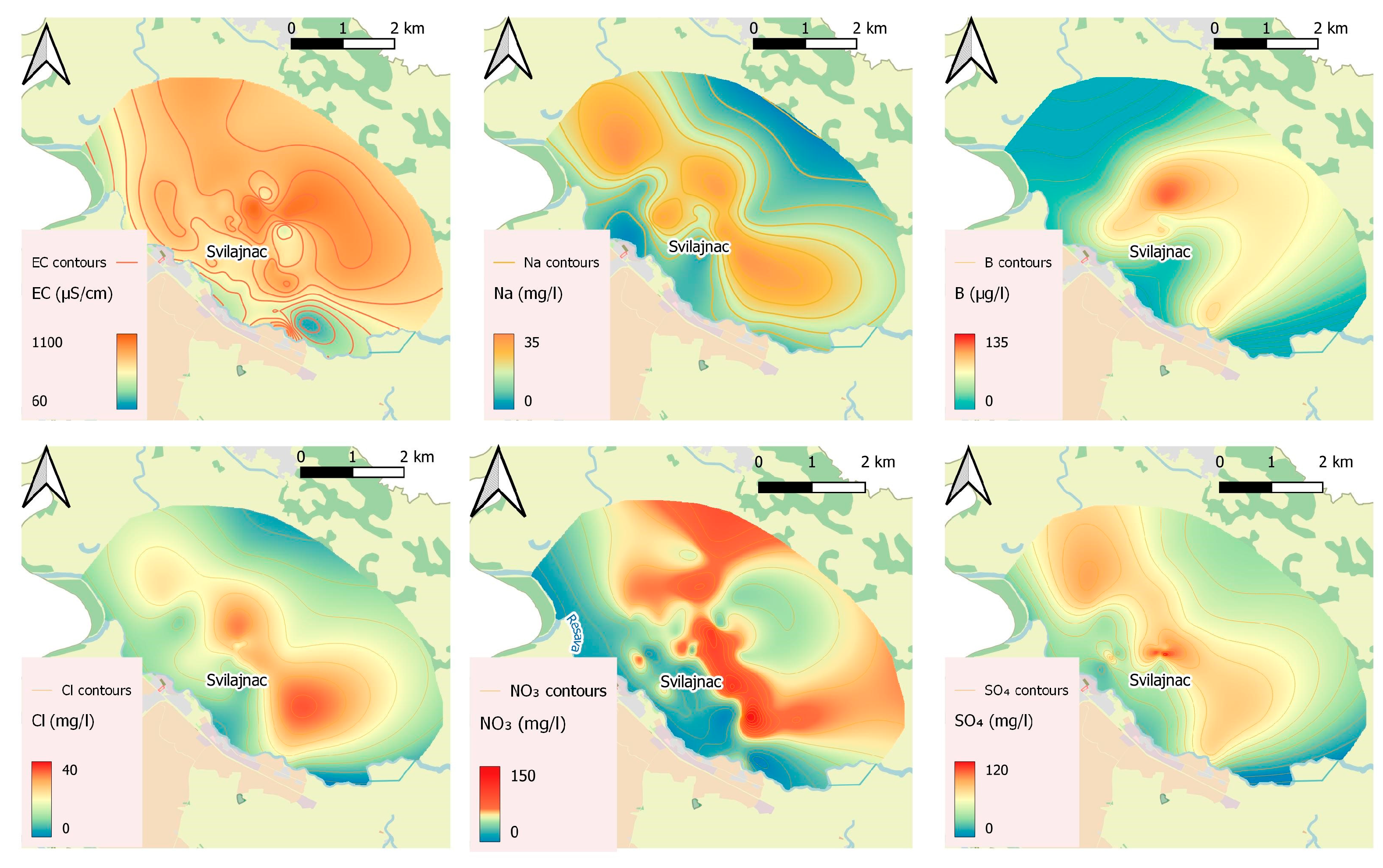
Based on groundwater quality data, the Perkićevo groundwater source is oxic, with an average dissolved oxygen concentration of 3.90 mg/L, a sporadically increased ammonium ion concentration (up to 2.10 mg/L), and an increased organic matter content (up to 15.80 mg/L of KMnO4 consumption). Nitrate levels range widely from below the quantification limit to 128.10 mg/L (Table 2). Total variance explained and extracted principal components (PCs) are presented in Table 3. The applied principal component analysis revealed that two extracted factors explain the majority of the variance (91%). The first extracted component (PC1) shows strong positive loadings between the anthropogenic impact parameters Cl, Na+, NO3, Ec, SO42−, and B (close to 1) (Figure 5). The second extracted factor (PC2) shows a strong positive loading (close to 0.9) between the organic matter content indicator (consumption of KMnO4), pH value, and dissolved oxygen concentration (Figure 6). This positive relation indicates that recharging water brings the oxygen and organic matter together in water characterized by higher pH values. This corresponds to the signature of untreated sewage, which brings together the organic matter and higher pH value. The presence of ammonium ions, which would be expected in sewage water, is not connected within this factor, likely due to oxygen-rich conditions and rapid nitrification. All measurement data from each groundwater sampling object are included in the Supplementary Material (Table S1).
According to the calculated Pearson’s linear correlation coefficients (Figure 7), nitrates, sulfates, sodium, and boron come from the same source, which causes the simultaneous increase in electroconductivity (Ec).

3.2.2. Surface Water

The average multi-annual discharge of the Velika Morava River, measured at the hydrological station in Bagrdan, is 199 m3/s (for the wide-range period of 1980–2010). Daily values varied in the range of 23 m3/s to 1830 m3/s, with minimum discharges occurring from July to November, and maximum discharges occurring most often in February, March, April, and May. The average multi-annual discharge of the Resava River, measured at the hydrological station in Svilajnac, is 4.50 m3/s (for the wide-range period of 1981–2010). Daily values varied in the range of 0.13 m3/s to 134 m3/s, with minimum discharges occurring from July to October, and maximum discharges occurring most often in February, April, May, and June. Based on the available data, it can be concluded that the main rivers recharging the groundwater have nitrate concentrations ranging from 1.28 to 13.16 mg/L (Velika Morava—Velika Plana) and 0.89 to 44.74 mg/L (Resava—Svilajnac) (Table 3). Based on the analyzed data on river water quality (Table 4), it can be concluded that the river is not a source of nitrate contamination for the groundwater in its alluvial region.

4. Discussion

Statistical processing of water quality data revealed the existence of anthropogenic pollution and untreated sewage inflow in the hinterland, whose weakening can be observed approaching the Resava River (Figure 5). The groundwater flow lines indicate the direction of groundwater movement in areas lacking proper sanitation, specifically in settlements with a water supply but no sewage system, such as Kušiljevo and Crkvenac. These groundwater flow lines completely coincide with the concentration change patterns of anthropogenic impact parameters Cl, Na+, B, SO42−, NO3, and electroconductivity. The consistent trends in pH, KMnO4 consumption, and dissolved oxygen (DO) indicate that biodegradable organic matter is associated with pH levels and oxygen, supporting the conclusion of sewage water intrusion.
The presented detailed hydrodynamic calculations yielded the following conclusions: Scenario 1 appears inadequate because it does not provide sufficient quantities of water. Scenarios 2 and 3 were selected as the most favorable for increasing the water capture capacity and protecting against nitrate infiltration. Scenario 4 would result in increased nitrate intrusion. To reduce nitrate inflow into the groundwater in the studied area, building sewage systems and implementing controlled agricultural practices (including fertilizer and manure applications) are necessary. Additionally, constructing a wastewater treatment plant is crucial but entails significant time and expense. Given these considerations, a practical and feasible solution to mitigate nitrate contamination in the study area’s groundwater under the current conditions is the use of water flow management and control.
After conducting an analysis of the existing water supply situation, as well as the overall physicochemical and hydrogeological conditions in the area, based on Modflow modeling results, Scenarios 2 and 3 proved to be the most favorable for the sustainable use of the Perkićevo groundwater source in terms of both quality and quantity. Utilization of existing facilities and quantities defined as available, (Scenario 2) with a Qavg.year = 55 L/s and a Qmax.day = 80 L/s, along with the necessary implementation of protective measures in the wider area has been deemed acceptable. Scenario 3, which implies expansion into Zone 2 (north of existing facilities), installation of new shallow wells, and capturing additional quantities from an alluvial aquifer at a rate of Qavg.year = 20 L/s and Qmax.day = 30 L/s is also recommended.
Based on the findings from the PCA, which effectively condensed and interpreted the dataset, we arrived at one key insight—a substantial portion of the variance (91%) could be explained by only two principal components. PC1 prominently linked several anthropogenic impact indicators (Cl, Na+, NO3, Ec, SO42−, and B), whose association suggests a coherent pattern of contamination likely influenced by human activities, primarily untreated sewage. By extracting indicators of the organic matter load (KMnO4 consumption), pH value, and dissolved oxygen concentration, PC2 implied that recharging water brings the organic matter load and higher pH values, supporting the indication gained from PC1. The findings not only highlight the dominant factors driving water quality variations but also provide valuable insights for targeted management strategies aimed at mitigating anthropogenic impacts and safeguarding groundwater resources.
When considering the optimal utilization and potential expansion of a nitrate-contaminated groundwater source, it is essential to consider the main areas of concern where pollutants are being introduced. These areas include the settlements with unregulated sewage of Kušiljevo, Crkvenac, and partially Lukovica, the town of Svilajnac, the nearby lagoon for sanitary wastewater, and the surrounding agricultural region. Currently available data indicate that it is crucial to implement specific measures to protect groundwater, primarily in the southeastern zone from the source, stretching from Svilajnac towards Lukovica, which has been identified as critical, and then in the western and northern zones from the source, which have been identified as vulnerable. The surroundings of the water source are unfavorable due to its proximity to residential buildings in Svilajnac and agricultural land. Constructing wells at planned locations north of Perkićevo to expand the water source would be ineffective without first addressing the existing pollutants and implementing preventive measures to mitigate the activation of potential contaminants. It is important to recognize that the significant impact of these actions on groundwater quality will only become evident after several years of natural flushing and groundwater purification.

5. Conclusions

The presented research involved simultaneous hydrogeochemical analysis and hydrodynamic calculations aimed at identifying nitrate sources in groundwater and proposing the optimal groundwater utilization scenario. The PCA analysis revealed that strong loading between sewage inflow indicators exists. The four examined scenarios with different Q values and well layouts were evaluated with the aim of determining which water extraction scenario would enable a sufficient quantity of potable water in the conditions of an already nitrate-impacted source. Scenarios 2 and 3 provide a significant quantity of water, accounting for approximately 80% of the total water abstracted from the direction of the Resava River. This is about 20% more than the amount provided in Scenario 4. Afterwards, based on the drawn conclusions, several necessary following steps are proposed, including controlling land use in areas where aquifers are recharged and managing sewage construction.
Regardless of the chosen scenario, it is necessary to establish sanitary protection zones by determining their boundaries and implementing protective measures as prescribed by the relevant legal acts. All activities affecting the quality of groundwater or surface water must be directed towards preventing harmful impacts and ensuring the required water quality. This entails establishing systems to treat industrial and sanitary wastewater. It also necessitates regulating the agricultural use of chemical pesticides, fertilizers, and manure, and implementing ‘good agricultural practices’ for the proper storage and management of manure, as stipulated by EU Regulation No. 1774/2002 on animal by-products (ABPs) [39]. Such measures ensure the sustained utilization of the source’s current capacity while fostering potential for its future expansion. Without adequate protection measures in place, the source’s existing and potential capacities remain at risk.
Due to the moderate list of monitored parameters, the presented research cannot identify other specific pollutants, implementation priorities, and strategies for groundwater protection. Future detailed monitoring is advised to provide up-to-date information, including examination of the isotopic signatures of nitrates. This would supplement the conclusions drawn regarding the origin of nitrates and the potential presence of transformation processes.
The conclusions from the hydrodynamic calculations suggest that the optimal solution is to extract an average quantity of water of • 55 L/s (existing condition) + 20 L/s (expansion to Zone 2 in projection) from the alluvial aquifer, totaling 75 L/s. The scenario of expanding the capacity of the source to Qavg = 20 L/s and Qmax = 30 L/s by using new shallow wells would be adequate if protective measures are previously implemented. The results of the overall assessment have led to the proposal of a new drinking water extraction area and recommendations for securing additional potable water resources.

Supplementary Materials

The following supporting information can be downloaded at: https://www.mdpi.com/article/10.3390/w16152105/s1, Table S1: All physicochemical measurement results.

Author Contributions

Conceptualization, M.P. and M.Z.; Methodology, V.Z.-R.; Software, V.Z.-R.; Validation, M.P. and M.Z.; Formal Analysis, M.Z.; Investigation, M.Z.; Resources, M.P.; Data Curation, V.Z.-R.; Writing—Original Draft Preparation, M.P.; Writing—Review and Editing, M.Z.; Visualization, V.Z.-R.; Supervision, M.P. All authors have read and agreed to the published version of the manuscript.

Funding

This research received no external funding.

Data Availability Statement

The original contributions presented in the study are included in the article; further inquiries can be directed to the corresponding author(s).

Acknowledgments

The authors extend their sincere gratitude to Zoran Radenković from the Jaroslav Černi Water Institute, Belgrade, Serbia, for his expert assistance, valuable advice, selfless support, and exceptional collegiality throughout the research and writing of this paper.

Conflicts of Interest

The authors declare no conflicts of interest.

References

  1. IARC Working Group on the Evaluation of Carcinogenic Risks to Humans. Ingested Nitrate and Nitrite, and Cyanobacterial Peptide Toxins; (IARC Monographs on the Evaluation of Carcinogenic Risks to Humans, No. 94.) 6, Evaluation and Rationale; International Agency for Research on Cancer: Lyon, France, 2010. Available online: https://www.ncbi.nlm.nih.gov/books/NBK326535/ (accessed on 21 June 2023).
  2. Dimkić, M.A.; Brauch, H.J.; Kavanaugh, M. Groundwater Management in Large River Basins; IWA Publishing: London, UK, 2008; ISBN 9781843391906. [Google Scholar]
  3. Pastén-Zapata, E.; Ledesma-Ruiz, R.; Harter, T.; Ramírez, A.I.; Mahlknecht, J. Assessment of sources and fate of nitrate in shallow groundwater of an agricultural area by using a multi-tracer approach. Sci. Total Environ. 2014, 470–471, 855–864. [Google Scholar] [CrossRef] [PubMed]
  4. World Health Organization. WHO Guidelines for Drinking Water Quality, 3rd ed.; WHO: Geneva, Switzerland, 2004. [Google Scholar]
  5. Arıman, S.; Soydan-Oksal, N.G.; Beden, N.; Ahmadzai, H. Assessment of Groundwater Quality through Hydrochemistry Using Principal Components Analysis (PCA) and Water Quality Index (WQI) in Kızılırmak Delta, Turkey. Water 2024, 16, 1570. [Google Scholar] [CrossRef]
  6. Banda, L.C.; Kalin, R.M.; Phoenix, V. Isotope Hydrology and Hydrogeochemical Signatures in the Lake Malawi Basin: A Multi-Tracer Approach for Groundwater Resource Conceptualisation. Water 2024, 16, 1587. [Google Scholar] [CrossRef]
  7. Ghannem, S.; Paredes-Arquiola, J.; Bergillos, R.J.; Solera, A.; Andreu, J. Assessing the Effects of Environmental Flows on Water Quality for Urban Supply. Water 2024, 16, 1509. [Google Scholar] [CrossRef]
  8. Perovic, M.; Obradovic, V.; Zuber-Radenković, V.; Obrovski, B.; Vojinovic-Miloradov, M.; Dimkić, M. Comprehensive Biogeochemical Analysis of Nitrogen Transformation Parameters. Water Resour. 2020, 47, 156–170. [Google Scholar] [CrossRef]
  9. Perović, M.; Dimkić, M. Transformation of Nitrogen Compounds in Groundwater; Chapter 8 in Alluvial Aquifer Processes; IWA Publishing: London, UK, 2021; ISBN 9781789060904. [Google Scholar]
  10. Weng, T.N.; Liu, C.W.; Kao, Y.H.; Hsiao, S.S.Y. Isotopic evidence of nitrogen sources and nitrogen transformation in arse-nic-contaminated groundwater. Sci. Total Environ. 2017, 578, 167–185. [Google Scholar] [CrossRef] [PubMed]
  11. Nikolenko, O.; Jurado, A.; Borges, A.V.; Knöller, K.; Brouyre, S. Isotopic composition of nitrogen species in groundwater under agricultural areas: A review. Sci. Total Environ. 2018, 621, 1415–1432. [Google Scholar] [CrossRef]
  12. Dimkić, M. Importance of the Aerobic State of Alluvial Aquifers for Groundwater use, Nakdong River International Water Week. In Proceedings of the 7th World Water Forum, September, Andong, Republic of Korea, 69–96, Conference “Contemporary Issues of Adaptive Water Management”, Belgrade, Serbia, 31 October 2012 ; pp. 29–37. [Google Scholar]
  13. Burgin, A.J.; Hamilton, S.K. Have we overemphasized the role of denitrification in aquatic ecosystems? A review of nitrate removal pathways. Front. Ecol. Environ. 2007, 5, 89–96. [Google Scholar] [CrossRef]
  14. Rivett, M.O.; Buss, S.R.; Morgan, P.; Smith, J.W.N.; Bemment, C.D. Nitrate Attenuation in Groundwater: A Review of Bioge-ochemical Controlling Processes. Water Res. 2008, 42, 4215–4232. [Google Scholar] [CrossRef]
  15. Perović, M.; Obradović, V.; Zuber-Radenković, V.; Knoeller, K.; Mitrinović, D.; Čepić, Z. The comprehensive evaluation of nitrate origin and transformation pathways in the oxic alluvial aquifer in Serbia. Environ. Sci. Pollut. Res. 2024, 31, 33030–33046. [Google Scholar] [CrossRef]
  16. Xue, D.; Botte, J.; De Baets, B.; Accoe, F.; Nestler, A.; Taylor, P.; Van Cleemput, O.; Berglund, M.; Boeckx, P. Present limitations and future prospects of stable isotope methods for nitrate source identification in surface-and groundwater. Water Res. 2009, 43, 1159–1170. [Google Scholar] [CrossRef] [PubMed]
  17. Gasser, C.A.; Ammann, E.M.; Shahgaldian, P.; Corvini, P.F.-X. Laccases to take on the challenge of emerging organic contaminants in wastewater. Appl. Microbiol. Biotechnol. 2014, 98, 9931–9952. [Google Scholar] [CrossRef]
  18. Ellis, J.B.; Bertrand-Krajewski, J. Assessing Exfiltration and Infiltration on the Performance of Urban Sewer Systems; Water Intelligence Online; IWA Publishing: London, UK, 2010; Volume 9. [Google Scholar]
  19. Lindebaum, J. Identification of Sources of Ammonium in Groundwater Using Stable Nitrogen and Boron Isotopes in Nam Du, Hanoi. Ph.D. Thesis, Lund University, Lund, Sweden, 2012. [Google Scholar]
  20. Kalagasidis Krušić, M. Organic Industrial Synthesis; Internal Script of the Department of Organic Chemical Technology, Faculty of Technology and Metallurgy, University of Belgrade: Belgrade, Serbia, 2017. (In Serbian) [Google Scholar]
  21. Widory, D.; Kloppmann, W.; Chery, L.; Bonnin, J.; Rochdi, H.; Guinamant, J.L. Nitrate in groundwater: An isotopic multi-tracer approach. J. Contam. Hydrol. 2004, 72, 165–188. [Google Scholar] [CrossRef] [PubMed]
  22. Bohlke, J.K.; Smith, R.L.; Miller, D.N. Ammonium transport and reaction in contaminated groundwater: Application of isotope tracers and isotope fractionation studies. Water Resour. Res. 2006, 42. [Google Scholar] [CrossRef]
  23. Drinking Water Directive, Council Directive 98/83/EC of 3 November 1998 on the Quality of Water Intended for Human Consumption. Available online: https://eur-lex.europa.eu/legal-content/EN/TXT/?uri=celex%3A31998L0083 (accessed on 21 June 2023).
  24. Council Directive 91/676/EEC of 12 December 1991 Concerning the Protection of Waters against Pollution Caused by Nitrates from Agricultural Sources, Nitrate Directive. Available online: https://eur-lex.europa.eu/eli/dir/1991/676/oj (accessed on 21 June 2023).
  25. Zhang, M.; Huang, G.; Liu, C.; Zhang, Y.; Chen, Z.; Wang, J. Distributions and origins of nitrate, nitrite, and ammonium in various aquifers in an urbanized coastal area, south China. J. Hydrol. 2020, 582, 124528. [Google Scholar] [CrossRef]
  26. Ledoux, E.; Gomez, E.; Monget, J.M.; Viavattene, C.; Viennot, P.; Ducharne, A.; Benoit, M.; Mignolet, C.; Schott, C.; Mary, B. Agriculture and Groundwater Nitrate Contamination in the Seine Basin. The STICS-MODCOU modelling chain. Sci. Total Environ. 2007, 375, 33–47. [Google Scholar] [CrossRef] [PubMed]
  27. Burow, K.R.; Nolan, B.T.; Rupert, M.G.; Dubrovsky, N.M. Nitrate in groundwater of the United States, 1991–2003. Environ. Sci. Technol. 2010, 44, 4988–4997. [Google Scholar] [CrossRef]
  28. Rivett, M.O.; Smith, J.W.N.; Buss, S.R.; Morgan, P. Nitrate occurrence and attenuation in the major aquifers of England and Wales. Q. J. Eng. Geol. Hydrogeol. 2007, 40, 335–352. [Google Scholar] [CrossRef]
  29. Zhang, Q.; Sun, J.; Liu, J.; Huang, G.; Lu, C.; Zhang, Y. Driving mechanism and sources of groundwater nitrate contamination in the rapidly urbanized region of south China. J. Contam. Hydrol. 2015, 182, 221–230. [Google Scholar] [CrossRef]
  30. Huang, G.; Liu, C.; Zhang, Y.; Chen, Z. Groundwater is important for the geochemical cycling of phosphorus in rapidly urbanized areas: A case study in the Pearl River Delta. Environ. Pollut. 2020, 260, 114079. [Google Scholar] [CrossRef]
  31. Reed, E.M.; Wang, D.; Duranceau, S.J. Evaluating Nitrate Management in the Volusia Blue Springshed. J. Environ. -Ment. Eng. 2018, 144, 3. [Google Scholar] [CrossRef]
  32. Reed, E.M.; Wang, D.; Duranceau, S.J. Modeling anthropogenic boron in groundwater flow and discharge at Volusia Blue Spring (FL, USA). Hydrogeol. J. 2017, 25, 91–101. [Google Scholar] [CrossRef]
  33. Correa-González, A.; Hernández-Bedolla, J.; Martínez-Cinco, M.A.; Sánchez-Quispe, S.T.; Hernández-Hernández, M.A. As-sessment of Nitrate in Groundwater from Diffuse Sources Considering Spatiotemporal Patterns of Hydrological Systems Using a Coupled SWAT/MODFLOW/MT3DMS Model. Hydrology 2023, 10, 209. [Google Scholar] [CrossRef]
  34. Kazakis, N.; Karakatsanis, D.; Ntona, M.M.; Polydoropoulos, K.; Zavridou, E.; Voudouri, K.A.; Busico, G.; Kalaitzidou, K.; Patsialis, T.; Perdikaki, M.; et al. Groundwater Depletion. Are Environmentally Friendly Energy Recharge Dams a Solution? Water 2024, 16, 1541. [Google Scholar] [CrossRef]
  35. Shakeri, R.; Nassery, H.R.; Ebadi, T. Numerical modeling of groundwater flow and nitrate transport using MODFLOW and MT3DMS in the Karaj alluvial aquifer, Iran. Environ. Monit. Assess. 2023, 195, 242. [Google Scholar] [CrossRef] [PubMed]
  36. Hafen, K.C.; Wheaton, J.M.; Roper, B.B.; Bailey, P.; Macfarlane, W.W.; Neilson, B.T.; Tennant, C.J. Estimating Increased Tran-sient Water Storage with Increases in Beaver Dam Activity. Water 2024, 16, 1515. [Google Scholar] [CrossRef]
  37. Ncibi, K.; Mastrocicco, M.; Colombani, N.; Busico, G.; Hadji, R.; Hamed, Y.; Shuhab, K. Differentiating Nitrate Origins and Fate in a Semi-Arid Basin (Tunisia) via Geostatistical Analyses and Groundwater Modelling. Water 2022, 14, 4124. [Google Scholar] [CrossRef]
  38. ISO/IEC 17025:2017; General requirements for the competence of testing and calibration laboratories. International Organization for Standardization: Geneva, Switzerland, 2017.
  39. Regulation (EC) No 1774/2002 of the European Parliament and of the Council of 3 October 2002 Laying Down Health Rules Concerning Animal by-Products not Intended for Human Consumption. Available online: https://eur-lex.europa.eu/legal-content/EN/TXT/?uri=celex%3A32002R1774 (accessed on 21 June 2023).
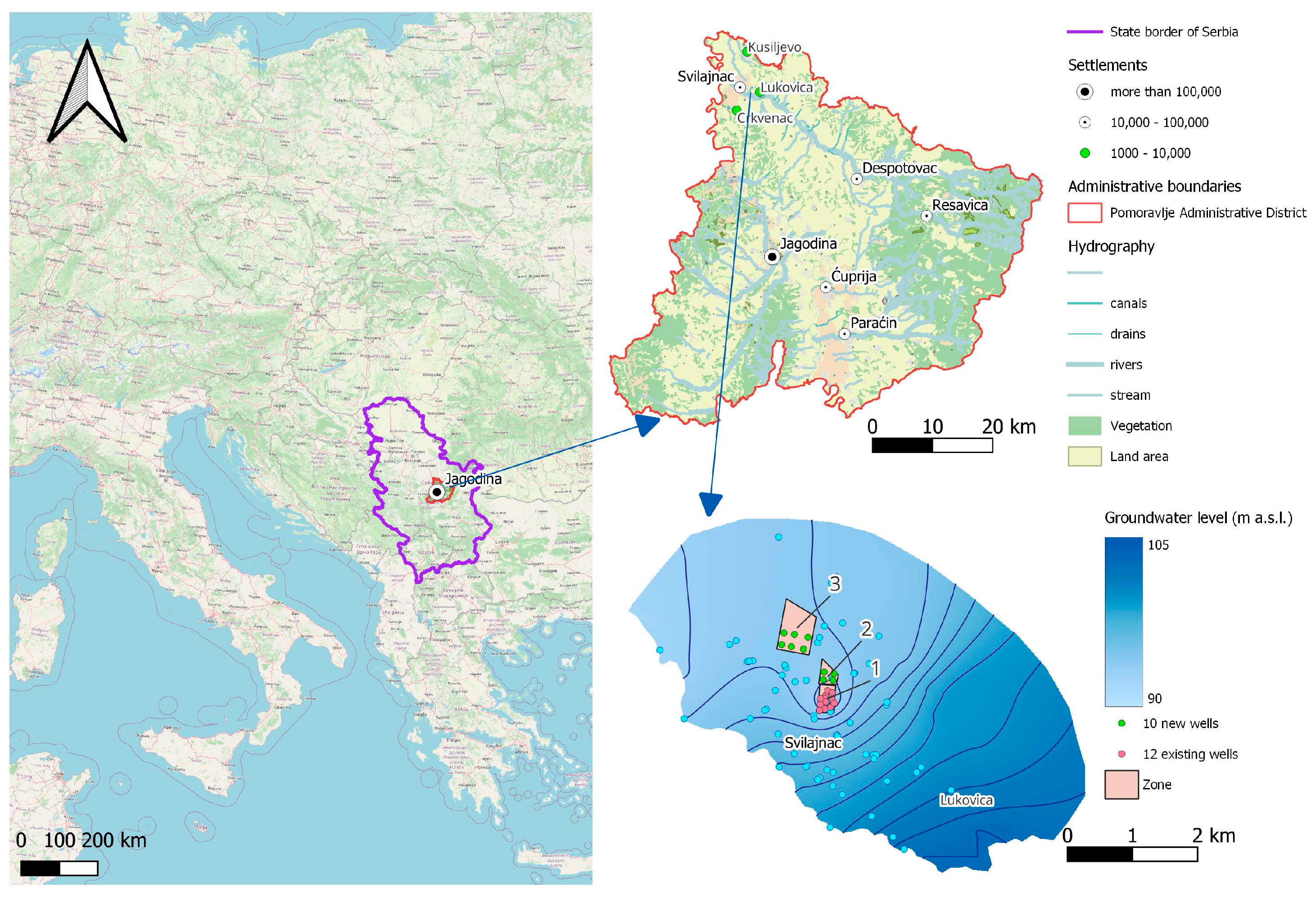
Figure 1. The location of the examined area, groundwater flow lines, marked sampling sites, and designated zones.
Water 16 02105 g001
Figure 2. Hydrogeological profile of examined alluvial plain.
Water 16 02105 g002
Figure 3. Diagram of the observed vs. calculated head values in the calibrated model.
Water 16 02105 g003
Figure 4. Four examined scenarios of groundwater extraction: (a) Scenario 1—existing state, average annual exploitation rate of Q = 55 L/s, with 12 existing wells (in Zone 1); (b) Scenario 2—existing state with maximum exploitation rate of Q = 80 L/s for a duration of three months during the dry period, with 12 existing wells (in Zone 1); (c) Scenario 3—average annual exploitation rate of Q = 75 L/s, with 12 existing wells and 4 new wells in Zone 2 (recommended source expansion—future state); and (d) Scenario 4—expansion of the water source to Zones 2 and 3, average annual exploitation rate of Q = 105 L/s, with 12 existing wells, 4 new wells in Zone 2, and 6 new wells in Zone 3 (potential source expansion—future state).
Water 16 02105 g004
Figure 5. Spatial gradients of parameter concentrations associated with PC1.
Water 16 02105 g005
Figure 6. Spatial gradients of parameter concentrations associated with PC2.
Water 16 02105 g006
Figure 7. Correlation matrix of selected variables (*—consumption of KMnO4).
Water 16 02105 g007
Table 1. Observed vs. Calculated Head Values in Calibrated Model.
Observed Value (m a.s.l.)Model Value (m a.s.l.)Observed Value (m a.s.l.)Model Value (m a.s.l.)Observed Value (m a.s.l.)Model Value (m a.s.l.)
93.6693.28100.8098.5294.0894.06
93.8393.1099.6998.4593.7193.41
93.3993.3699.6898.3694.0093.36
94.1193.52100.0698.5294.1993.65
93.5493.2795.0995.4494.7594.71
93.5093.2194.9295.4894.5494.36
93.7193.3995.6095.7594.8494.57
94.9094.8695.8595.6494.6394.06
95.0294.6095.0295.3594.3494.02
94.7594.9095.0295.2894.6094.10
95.4695.1695.1795.5094.7793.89
94.8195.0793.6793.3594.5194.22
94.7994.7794.0993.2195.0894.50
94.9994.7193.4293.5495.4194.52
99.7298.9394.0193.8494.8494.57
99.8898.7593.5994.0494.6394.06
100.1398.9993.2093.3894.3494.02
99.8098.4693.5293.3494.6094.10
99.3098.6294.1593.6394.7793.89
99.2898.5994.0693.3794.5194.22
99.5398.2394.0193.2295.0894.50
99.5798.5593.8593.5695.4194.52
100.5498.8394.5793.87
Table 2. Basic statistics of selected quality parameters in groundwater (for the entire examined area in the period 2006–2013).
ParameterUnitNo. *MeanMedianStd. Dev.MinMaxPercentiles
255075
pH 1137.227.200.236.677.687.107.207.40
KMnO4 consumptionmg/L794.083.471.951.7315.803.163.474.43
NH4+mg/L1020.040.030.21<0.022.10<0.020.030.03
Clmg/L8624.3522.258.368.0442.0018.9322.2530.05
NO2mg/L860.010.0020.04<0.0020.34<0.0020.0020.003
NO3mg/L19953.7248.0028.16<0.05128.1033.2048.0072.00
EcµS/cm168780.42781.00139.81254.001120.00692.50781.00875.00
Fetotmg/L570.150.030.28<0.011.220.010.030.20
Mntotmg/L570.01<0.010.04<0.010.32<0.01<0.010.01
SO42−mg/L4680.0473.2436.3935.01247.7057.8573.2492.45
Na+mg/L2819.0617.757.166.9532.4514.3217.7525.21
Bµg/L1764.2671.6023.3523.45110.8449.7571.6078.65
DO **mg/L183.903.151.701.877.622.683.155.31
Notes: * No.—number of samples. ** DO—dissolved oxygen
Table 3. Total Variance Explained and Extracted Principal Components (PCs).
PCsFactor
Loadings
Initial EigenvaluesRotation Sums of Squared Loadings
Total% of VarianceCumulative %Total% of VarianceCumulative %
PC1Cl0.9915.6763.0163.015.6462.6662.66
NO30.979
Ec0.991
SO42−0.975
Na0.994
B0.837
PC2pH0.8602.5127.8890.892.5428.2390.89
KMnO40.934
DO0.950
Table 4. Basic statistics of selected quality parameters in surface waters.
Velika Morava—Velika PlanaUnitNo. *MeanMedianStd. Dev.MinMaxPercentiles
255075
pH 218.018.000.327.408.507.808.008.30
EcµS/cm34441.50447.0055.63315.00596.00400.50447.00468.75
KMnO4
consumption
mg/L423.703.601.171.706.202.903.604.40
NH4+mg/L370.090.080.05<0.0010.200.070.080.11
NO3mg/L426.716.652.851.2813.164.426.658.86
NO2mg/L320.0050.0000.011<0.0030.039<0.003<0.0030.003
SO42−mg/L1623.6923.004.9614.0034.0020.2523.0026.00
Clmg/L169.009.052.694.1015.008.009.0510.75
Na+mg/L1611.0211.002.067.4015.609.5011.0012.28
Fetotµg/L14159.67188.50126.820.05406.000.19188.50227.75
Mntotµg/L1444.8640.5050.360.01200.000.0440.5053.75
TNmgN/L82.982.501.781.507.202.032.503.05
DOmg/L429.419.552.083.0012.508.009.5511.00
Resava—SvilajnacUnitNo.MeanMedianStd. Dev.MinMaxPercentiles
255075
pH 588.178.300.277.608.507.988.308.33
EcµS/cm95486.25493.0060.90314.00644.00452.00493.00519.00
KMnO4
consumption
mg/L1002.602.301.030.805.801.902.303.00
NH4+mg/L980.100.010.320.013.000.010.010.08
NO3mg/L999.507.806.890.8944.746.117.8011.08
NO2mg/L980.030.010.08<0.0030.530.010.010.01
SO42−mg/L6826.1627.008.2211.0048.0020.0027.0030.00
Clmg/L687.947.005.292.0034.605.007.009.00
Na+mg/L358.508.302.512.8015.306.608.3010.50
Fetotµg/L31177.03140.00120.9830.00540.0080.00140.00250.00
Mntotµg/L3154.2635.0082.6710.00445.0010.0035.0056.00
TNmgN/L233.612.602.381.2010.302.102.604.60
DOmg/L10010.4210.102.004.8015.109.1310.1012.00
Note: * No.—number of samples.
Disclaimer/Publisher’s Note: The statements, opinions and data contained in all publications are solely those of the individual author(s) and contributor(s) and not of MDPI and/or the editor(s). MDPI and/or the editor(s) disclaim responsibility for any injury to people or property resulting from any ideas, methods, instructions or products referred to in the content.