Article

An Ensemble of Weight of Evidence and Logistic Regression for Gully Erosion Susceptibility Mapping in the Kakia-Esamburmbur Catchment, Kenya

by
Lorraine K. Nkonge
1,
John M. Gathenya
2,
Jeremiah K. Kiptala
3,
Charles K. Cheruiyot
3 and
Andrea Petroselli
4,*
1
Civil Engineering (Environment, Arid and Semi-Arid Lands), The Pan African University Institute for Basic Sciences, Technology and Innovation (PAUSTI), Jomo Kenyatta University of Agriculture and Technology, Nairobi P.O. Box 62000-00200, Kenya
2
Soil, Water and Environmental Engineering Department, Jomo Kenyatta University of Agriculture and Technology, Nairobi P.O. Box 62000-00200, Kenya
3
Department of Civil, Construction and Environmental Engineering, Jomo Kenyatta University of Agriculture and Technology, Nairobi P.O. Box 62000-00200, Kenya
4
Department of Economics, Engineering, Society and Business Organization (DEIM), Tuscia University, 01100 Viterbo, Italy
*
Author to whom correspondence should be addressed.
Water 2023, 15(7), 1292; https://doi.org/10.3390/w15071292
Submission received: 30 January 2023 / Revised: 13 March 2023 / Accepted: 20 March 2023 / Published: 24 March 2023
(This article belongs to the Special Issue Soil Erosion Measurement Techniques and Field Experiments)

Abstract

:
Gully erosion is the most intensive type of water erosion and it leads to land degradation across the world. Therefore, analyzing the spatial occurrence of this phenomenon is crucial for land management. The objective of this research was to predict gully erosion susceptibility in the Kakia-Esamburmbur catchment in Narok, Kenya, which is badly affected by gully erosion. GIS and ensemble techniques using weight of evidence (WoE) and logistic regression (LR) models were used to map the susceptibility to gully erosion. First, 130 gullies were detected in the study area and portioned out 70:30 for training and validation, respectively. Nine gully erosion conditioning factors were selected as predictors. The relationships between the gully locations and the factors were identified and quantified using WoE, LR and WoE–LR ensemble models. The results show that land use/cover, distance to road, sediment transport index (STI) and topographic wetness index (TWI) are the factors that have the most influence on gully occurrence in the catchment. Additionally, the WoE–LR model performed better than the WoE and LR models, producing an AUC value of 0.88, which was higher than that of the WoE model, 0.62 and the LR model, 0.63. Therefore, the WoE–LR ensemble model is useful in gully erosion susceptibility mapping and is of help to decision makers in land-use planning.

1. Introduction

Soil erosion caused by water is considered to be one of the primary causes of land degradation worldwide [1]. Soil erosion, which is a natural process that entails detachment, transportation and deposition of soil particles, can be exacerbated by anthropogenic activities [2]. Water induced soil erosion is usually caused by deforestation, climate change, intensification of agriculture, urbanization and tectonic activities, all of which threaten land and water resources sustainability [3]. Soil erosion leads to reservoir siltation [4]; loss of fertile topsoil [5]; flooding and decline in species [6,7]; and eutrophication in streams, reservoirs and lakes [8]. Furthermore, there has been an increase in soil erosion rates over the years [9], for instance soil erosion is responsible for soil loss in most landscapes in Ethiopia and Kenya [10].
Water erosion occurs in various forms including splash, interrill (sheet), rill, stream bank and gully erosion [11]. Gully erosion is the most complex type of erosion amongst these, as it is triggered and accelerated by heavy rainfall and land use change [12]. Studies conducted around the world have shown that gully erosion can contribute between 10% and 94% of the total catchment erosion [13]. Gullies decrease soil productivity through the incision of agricultural lands, and cause restrictions on roads, land use and structures [14].
A gully is defined as an erosion channel with steep side walls and head-cut that is actively eroding due to the surface flows that remove and transport soil particles [15]. It can be defined as having a cross-sectional area greater than 929 cm2 [13], and is too big to be removed by ordinary tillage practices [16]. Gully erosion is a threshold process and therefore several studies have put emphasis on defining the topographic as well as hydraulic conditions to predict gully erosion susceptibility [16,17].
In contrast to the significant contribution of gullies to total erosion on watersheds, few models have been developed for quantifying the effects of this phenomenon [18]. There are few physically based models that can assess gully erosion. They include CREAMS (chemicals, runoff and erosion from agricultural management systems), EGEM (ephemeral gully erosion mode) and WEPP (Water Erosion Prediction Project), which have been applied in the Loess Plateau [19,20]. However, the above models need a lot of geophysical and geochemical input data. Furthermore, the physical methods cannot assess the spatial distribution of gullies, which is important in visualizing the exposure of an area to gullying [21]. In regions where there is data scarcity, statistical and data mining methods can be successfully used.
Natural hazards have been assessed using a variety of data mining, bivariate and multivariate statistical methods. Some of these have been used to assess the susceptibility to gully erosion. Logistic regression (LR) [14,22]; weight of evidence (WoE) [23]; maximum entropy (ME) [24]; stochastic gradient tree boost (SGT) [16]; frequency ratio (FR) [25]; random forest (RF) [26]; multivariate adaptive regression splines (MARS) [17,27]; index of entropy (IoE) [28]; certainty factor (CF) [29] and support vector machine (SVM) [30].
All the aforementioned techniques have some drawbacks in the effectiveness of their predicted results, despite being able to determine gully erosion susceptibility. These disadvantages can be reduced through ensemble modeling. Recently, ensemble modeling has received significant attention in the spatial prediction of natural hazards such as landslides [31], groundwaters [32], droughts [33] and floods [34] due to improved prediction performance and the ability to deal with complex data [11]. Ensemble methods are techniques in which a prediction model is formed from a combination of various base classifiers [35].
WoE and LR have been used in particular in gully erosion susceptibility mapping, nonetheless, they have their own weaknesses. The main advantage of WoE is that it calculates the weight of the factors through statistical methods and thus avoids subjective weighting. In addition, input maps with missing data can be accommodated and have no significant impact on the result [23]. However, it neglects the correlation between the factors, which is important in gully erosion susceptibility because the conditioning factors should not be correlated. LR is able to evaluate the association between conditioning factors but it cannot analyze the influence of different classes within a conditioning factor [36]. Hence, their drawbacks can be solved and performance improved through their integration.
Starting from such premises, the main objectives of this study were to: (i) determine the level of influence of environmental conditioning factors causing the occurrence of gully erosion in the study area and (ii) assess the capability of WoE–LR to predict gully erosion susceptibility.

2. Materials and Methods

2.1. Study Area

The study area is composed of Kakia and Esamburmbur sub-catchments, which are 30.5 km2 and 15.7 km2, respectively (Figure 1), and are located in Narok County, South-West of Kenya. It lies between longitudes 35.83 ° E and 35.93 ° E and between latitudes 1.00 ° S and 1.10 ° S. The region’s elevation ranges from 1828 to 2147 m above sea level [37]. The main drainage channel is the permanent Enkare Narok River, which rises from the Mau Forest and flows through Narok town. The Enkare Narok has two tributaries, which are the seasonal Esamburmbur and Kakia streams that flow through Narok town and converge a few meters before draining into it [38]. The catchment experiences bimodal rainfall in a year [36]. The long rainy season is usually between the months of March and May, while the short rainy season occurs between October and December. The mean annual rainfall for the area is 750 mm while the temperature range for the area is between 8 °C and 28 °C [39]. The main land use/cover in the catchment includes cropland, forests, built-up areas and shrubs. Cropland, which is the main land use, is made up of crops such as maize and wheat [38].

2.2. Methodology

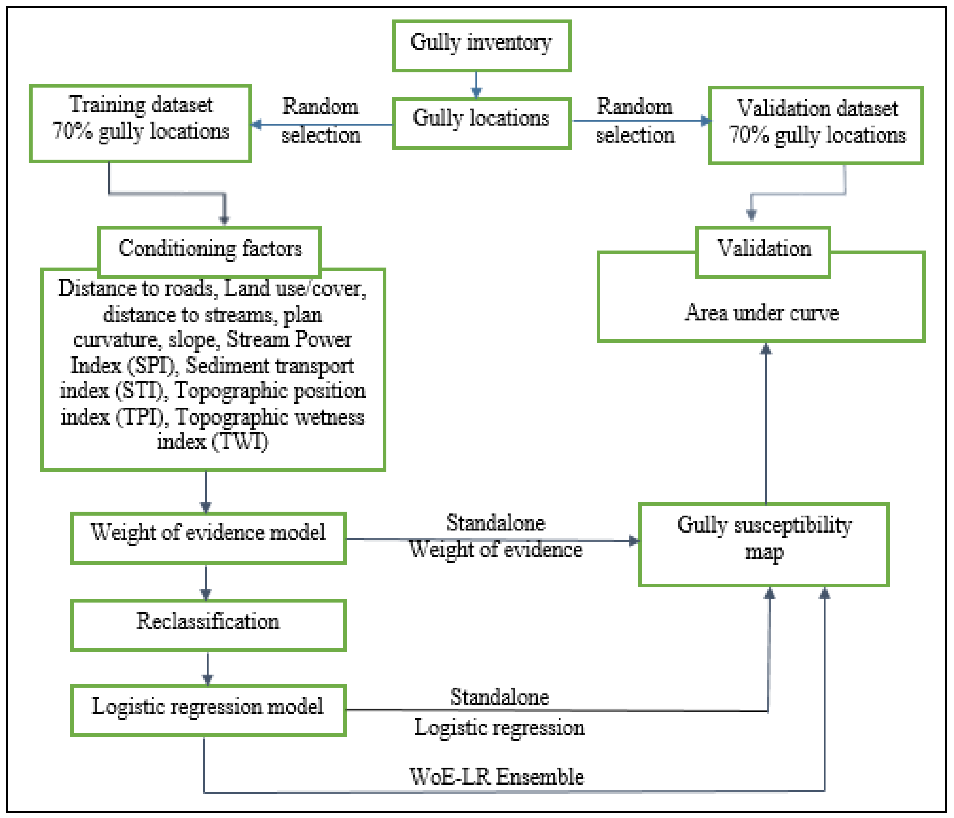
Gully erosion susceptibility was carried out in four steps including: (1) preparation of a gully inventory which contains locations of gullies in the catchment; (2) preparation of the gully conditioning factors; (3) gully erosion susceptibility modeling using WoE and WoE–LR; and (4) model evaluation by constructing the receiver operating characteristic (ROC) curve and calculating the area under the ROC curve (AUC). Figure 2 is a flow diagram indicating the methodology used in this study.

2.2.1. Gully Erosion Inventory

Gully erosion mapping in the Kakia-Esamburmbur catchment was performed through field survey using GPS and Google Earth satellite images. Figure 3 shows some of the gully erosion in the study area. Eventually, a reliable and detailed inventory map with a total of 130 gullies was created. The gully locations were randomly divided into two groups which include the training (70%) and the validation (30%) sets, and which were differentiated from one another using a random dividing algorithm [40]. Both the training and validation sets were merged with an equal number of randomly selected locations that represent absence of gully erosion [24]. The absence dataset was created in ArcGIS by using the random-point tool [24].

2.2.2. Conditioning Factors

There are various environmental factors that control the critical conditions for gully development and these are mainly related to rainfall, topography, soil and land use [18]. In order to recognize the susceptible areas, good knowledge of the main gully erosion-related factors is needed. Therefore, conditioning factors were chosen from previous studies [21,41]. In this study, ArcGIS, QGIS and a system for automated geoscientific analyses (SAGA) were used to generate and exhibit such a data grid. The conditioning factors that were used in this study are (1) slope, (2) plan curvature, (3) topographic wetness index (TWI), (4) distance to streams (m), (5) distance to roads (m), (6) topographic position index (TPI), (7) stream power index (SPI), (8) sediment transport index (STI) and (9) land use/land cover.
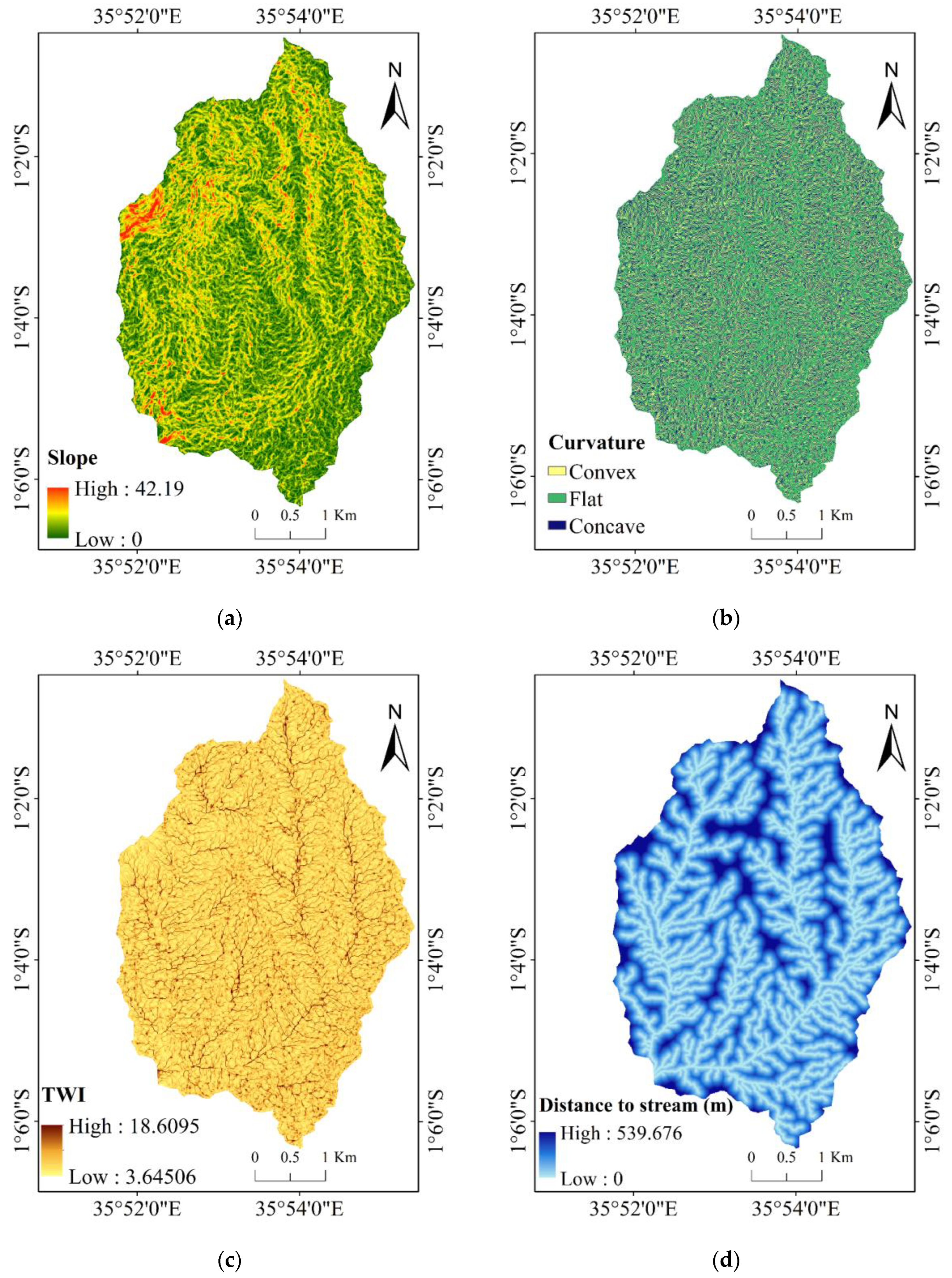
Slope controls the velocity and volume of concentrated flow thus affecting surface erosion and soil erosion [18]. Slope was derived from a 12.5 m resolution DEM from ALOS PALSAR [42] using ArcGIS and ranges from 0% to 42.19% (Figure 4a). Curvature assessment is important for inferring suitable geomorphological data. Plan curvature influences slope erosion processes through the convergence and divergence of water fluxes downhill. In this research, the plan curvature was derived from the DEM with a spatial resolution of 12.5 m in ArcGIS. The plan curvature values range from −3.2 to 3.2 (Figure 4b). Plan curvature can be classified into three classes: concave (positive curvature), flat (zero curvature) and convex (negative curvature) conditions, which were used in this study [36].
Topographic wetness index (TWI) is a secondary topographic factor that is used to evaluate the hydrological features of a region and is a crucial gully erosion determining factor. It represents the spatial distribution of wetness conditions [43]. It was calculated using Equation (1). The ArcGIS software was used for TWI mapping and the values range from 3.6 to 18.6 (Figure 4c).
TWI = ln A c tan   β  
where
A c = upstream contributing area (m2) and
β = slope gradient (°).
Distance to streams is important in evaluating the role of runoff in gully erosion [44]. Road construction has an adverse influence on hill sustainability at which flow may be suitable for gullies [18]. They were both calculated in ArcGIS using the Euclidean distance tool, which will give the distance (m) from each raster cell to the closest stream/road section [45]. The distance ranged from 0 to 2530 m for streams (Figure 4d) and 0 to 1674 m for roads (Figure 5a).
Topographic position index (TPI) is a widely used approach for evaluating topographic slope location. It is the difference between the elevation of a cell and the average of the surrounding cells [17]. It was calculated for each cell using the algorithm [46] denoted by Equation (2) in QGIS using SAGA-GIS. The TPI values for the study area range between −6.7 and 7 and were divided into five classes (Figure 5b).
T P I = Z 0 Z
where
Z 0 = elevation at the central point and
Z = average elevation around it within a predetermined radius (R).
The stream power index (SPI) has direct proportionality to stream power, which is the time rate of energy being used, and therefore can be used to estimate the overland flow erosive power. The SPI reflects the discharge and flow erosive power, which influences gully erosion susceptibility [47]. A higher value of SPI indicates that the stream has a much more powerful erosion on the slope surface [35]. The SPI value was calculated from the DEM in ArcGIS using the Equation (3).
SPI = A c   ×   tan β  
where A c is the upstream contributing area (m2) and β is slope gradient (°). The SPI values of the study area range between 0 and 13,639 (Figure 5c).
The sediment transport index (STI) has been used to analyze erosion and deposition processes and topographic effects on soil loss. It was calculated using Equation (4) [28] in ArcGIS.
STI = A c 22.13 0.6 sin β 0.0896 1.3
where A c is the upstream contributing area (m2) and β is slope gradient (°). The STI values in the study range from 0 to 246 and were classified into five classes (Figure 5d).
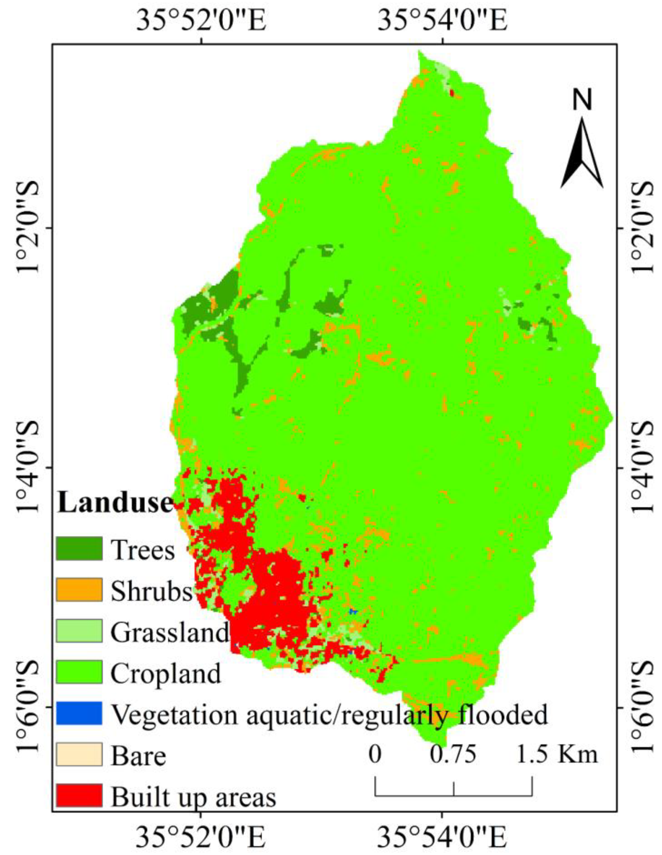
Land use/land cover (LULC) has a significant influence on hydrological and geomorphological pathways due to its direct or indirect effect on infiltration, evapotranspiration, runoff and sediment dynamics [48]. It also influences nutrients, structure and soil properties [45]. Vegetation protects the soil against erosion and surface runoff. Roots offer reinforcement thus increasing shear strength of the soil [45]. The land use/land cover map was acquired from Sentinel-2 [49] and prepared in ArcGIS. It has seven classes, i.e., trees, shrubs, grassland, cropland, vegetation aquatic/regularly flooded, bare and built-up areas (Figure 6).

2.3. Multi-Collinearity Test

As the independent variable, the above-mentioned conditioning factors were used to examine the effect of correlation among them. It is a problem in the modeling process if both predictor variables are strongly related. The problem is known as collinearity. Tolerance and the VIF (variance inflation factor) are both significant measures of multi-collinearity identification. Tolerance is the inverse of VIF [50]. The test was carried out in the R software.

2.4. Weight of Evidence Model

The weight of evidence (WoE) is a probabilistic approach model based on a log linear form of Bayes’ theorem of conditional probability [51]. It has been used for flood susceptibility mapping [37] and landslide susceptibility mapping [52]. By overlaying gully locations with each conditioning factor, their statistical relationship can be identified and assessed to establish whether and how significantly the conditioning factor is responsible for gully occurrence. WoE is expressed as shown in Equation (5)
P A B = P B A × P ( A ) P ( B )
where A represents the presence of a gully and B represents the presence of the gully conditioning factor. Conditional independence is a very important aspect that should be considered in the WoE method. Positive, W+ and negative, W- weights are used to calculate the WoE model. The weight for each B is calculated based on the presence or absence of A as shown in Equations (6) and (7).
W + = ln P B A P B A
W = ln p B A p B A
where P denotes the probability and l n denotes the natural log function. A and A indicate the presence and absence of a gully, respectively. The presence of a gully conditioning factor is represented by   B , and the absence of a gully conditioning factor is represented by B . A positive ( W + ) weight explains the presence of the conditioning factor at the gully location and its value indicates the correlation between the gullies and the gully conditioning factor [53]. A negative ( W ) weight explains the gully conditioning factor’s absence and indicates the degree of negative correlation [41]. The final weight, W final = W + W will be used to quantify and indicate the spatial relationship between the effective gully conditioning factors and gully occurrence. If W final is positive, it indicates a positive spatial relationship and if it is negative, it indicates a negative spatial relationship [40]. After applying the WoE model, the weights of the factors W final were summed to produce a map of gully erosion susceptibility based on the Equation (8) [54].
GESI = W final
where   GESI is the gully erosion susceptibility index.

2.5. Logistic Regression Model

Logistic regression (LR) is a multivariate statistical technique used in the development of predictive models from either discrete or continuous explanatory variables [18]. LR allows the development of a multivariate regression association linking a dependent variable and explanatory variables, which are important in predicting presence or absence of an outcome based on values of a set of explanatory variables [51]. In this case, the outcome is the presence of gullies and the LR is applied to predict variable (Y) that can be equal to presence of gully (1) or absence of gully (0). The LR uses a logistic function to assess the association linking the dependent variable and the explanatory variables. The logistic function is expressed as Equation (9) [52].
P = 1 1 + e l
where P is the probability of gully erosion occurrence, which varies from 0 to 1 and l is the linear logistic factor, whose value varies from   to + and is defined by Equation (10).
l = intercept + b 1 x 1 + b 2 x 2 + + b k x k
where x 1 , x 2 and x k are the explanatory variables and b 1 , b 2 and b k are the coefficients of the LR model. In this study, LR was performed using the R software and ArcGIS, adopting forward stepwise regression to select the explanatory variables.
For the LR–WoE ensemble model, the determined class values of the WoE model were used to create the input for the LR model. The LR model requires a numerical rather than a categorical dependent variable. In order to address this issue, the weights of the classes of the conditioning factors were determined using the WoE model. The weights were then employed to transform the categorical variables into numerical variables. Therefore, all the classes of the conditioning factors were converted to numerical variables as shown in Table 1 and Table 2. Finally, using the natural break method, the gully susceptibility map was reclassified into very low, low, moderate, high and very high classes after applying the LR–WoE model [22].

2.6. Model Evaluation

The model performance was evaluated by drawing the receiver operating characteristic (ROC) and calculating the area under the curve (AUC). It was generated by plotting the sensitivity, also known as true positive rate (TPR), on the y-axis, Equation (11) against the 1-specificity, which is the false positive rate (FPR), on the x-axis using Equation (12) [52]. A ROC of 1 indicates perfect prediction. The model sensitivity is the percentage of existing gully pixels correctly predicted using the model, while the 1-specificity is the percentage of predicted gully pixels over the total study area.
y - axis = TPR = TP TP + FN
x - axis = FPR = 1 TN TN + FP
where TP stands for true positive, TN stands for true negative, FP stands for false positive and FN stands for false negative. The TP and TN are the proportions of gully cells that are correctly classified as gully and non-gully, while the FP and FN are the proportions of gully cells that are incorrectly classified as gully and non-gully [11]. The AUC is a common method for assessing models used in prediction of natural hazards [55,56]. The AUC is calculated using the Equation (13).
AUC = TP + TN / P + N
where P denotes the total number of gullies and N denotes the total number of non-gullies.

3. Results

3.1. Conditioning Factor’s Effect

3.1.1. Multicollinearity Test

The VIF ranges from 1.04 to 2.49, according to the multicollinearity test, while the TOL, which is the reciprocal of the VIF, ranges from 0.40 to 0.96. (Table 1). VIF values greater than five, with corresponding TOL values less than 0.2, indicate significant multicollinearity among factors [57]. The results indicate that there is no multi-collinearity between the conditioning factors.

3.1.2. Weight of Evidence Model

It is observed that there is a higher chance of gully occurrence at the high slope range of 16.1–42.1 while the lower slope classes have a low possibility of gully occurrence, which means the relationship is positive as seen from Table 2. The convex curvature had the highest Wfinal value, indicating that such areas in the study area are most vulnerable to gully erosion. From the results it can be seen that higher values of TWI indicate a higher chance of gully erosion occurrence while lower values indicate lower chances of gully erosion occurrence, thus there is a positive association. This can be attributed to the fact that at low TWI, less runoff is generated and at higher TWI, gully development is encouraged [54].
The results in Table 2 show that there is a higher possibility of gully occurrence near a road network. This can be seen through the high positive value of the final weight for the least distance from the roads (Wfinal = 4.1). This can be explained by the fact that the development of roads leads to soil disturbance which exacerbates gully formation [47].
TPI has a negative relationship with gully erosion. The lowest values of TPI had the highest Wfinal values while the highest TPI values had the lowest Wfinal values. Table 3 shows that higher values of SPI are associated with higher chances of experiencing gully erosion and vice versa.
This shows that gully occurrence increases with an increase in SPI. This can be attributed to the fact that SPI is a product of slope and catchment area. It is used in showing areas of concentrated runoff and thus higher values of SPI indicate higher chances of experiencing gully erosion. The results also agree with a study carried out by [58].
Lower STI values have lower Wfinal values while higher STI values have higher Wfinal values. There is a positive association between STI and gully erosion. It indicates that gully occurrence increases with an increase in STI. This can be attributed to the fact that STI accounts for topographic effect on erosion. Similar results were also found in research carried out by [23].
The main land coverages which were identified in the catchment are: trees, shrubs, grassland, cropland, vegetation aquatic/regularly flooded, bare and built-up areas. The built-up area is mostly around Narok town at the outlet of the catchment. The bare land cover class has a high positive final weight (Wfinal = 4.0) while the built-up area has the highest negative final weight (Wfinal = −2.2).
These results show that there is a positive association between gully erosion occurrence and bare land while there is a strong positive association between the occurrence of gullies and built-up areas. From the above results, there is an implication that change in land cover/use from forest to agriculture, which increases the presence of bare soil, leads to gully development in the study area.
These findings agree with [59] who found that there is an association between gully erosion formation with the change in land cover/use from forest to cropland. Land use change has occurred in the Kakia-Esamburmbur catchment where forest cover has declined by 39% and agriculture has increased by 55.4% [39]. These findings are in agreement with the knowledge that forested areas experience less erosion in the form of gullies than barren land or wastelands [60].

3.1.3. Logistic Regression Model

The result for the LR model is given by Equation (14).
Z = 23.4199 + 5.519 × slope + 1.890 × curvature + 7.590 × SPI + 1.183 × Distance   to   road + 5.323 × STI + 0.639 × Distance   to   stream + 2.211 × TPI + 4.154 × LULC + ( 5.994 × TWI )

3.1.4. LR–WoE Ensemble Model

The LR–WoE ensemble model developed for prediction of gully erosion susceptibility in the study area at 10% significance level is given by Equation (15). The significance of the conditioning factors is shown in Table 4.
Z = −7.026 + (0.061 × TWI) + (0.03 × Distance to stream) + (0.007 × Distance to road) − (0.023 × STI) + (0.008 × LULC)
From Equation (15) it is obvious that TWI, distance to stream, distance to road and LULC have positive coefficients.
This means that these factors are related to the occurrence of gullies in a positive way. The coefficient of STI, on the other hand, is negative, indicating a negative relationship with the occurrence of gullies in the study area.

3.2. Gully Erosion Hazard

3.2.1. Weight of Evidence Model

The total weight, which is a result of summing the final weight (Wfinal) values presented in Table 2 and Table 3, is shown in Figure 7. The total weighted map was converted into five classes: very low, low, moderate, high and very high hazard. It can be seen from the map that the areas around the forests have very low susceptibility levels. This implies that increasing forest cover in the Kakia-Esamburmbur catchment can be carried out in order to reduce soil erosion. The majority of the catchment that has moderate to high susceptibility levels is agricultural land.

3.2.2. LR Model and WoE–LR Ensemble Model

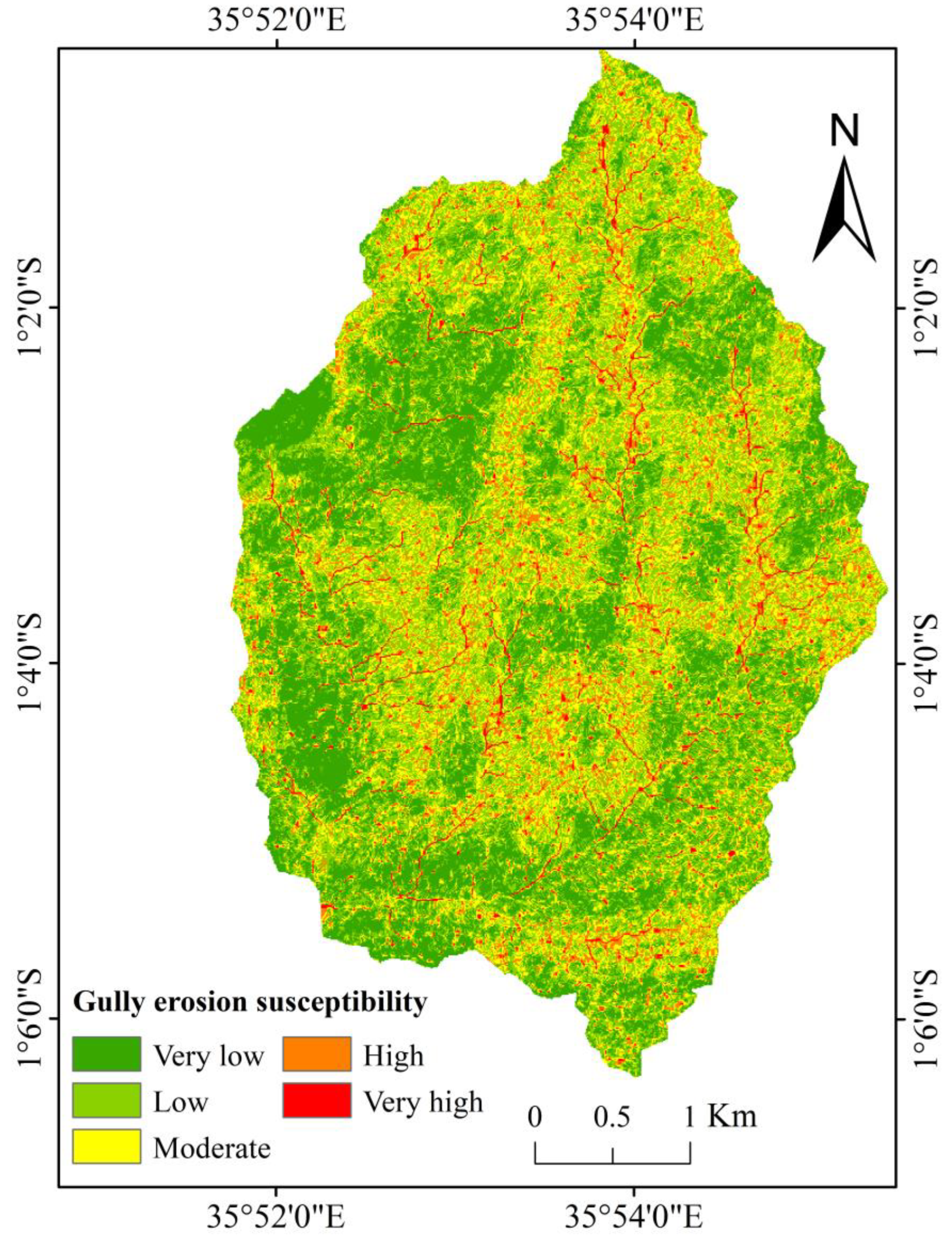
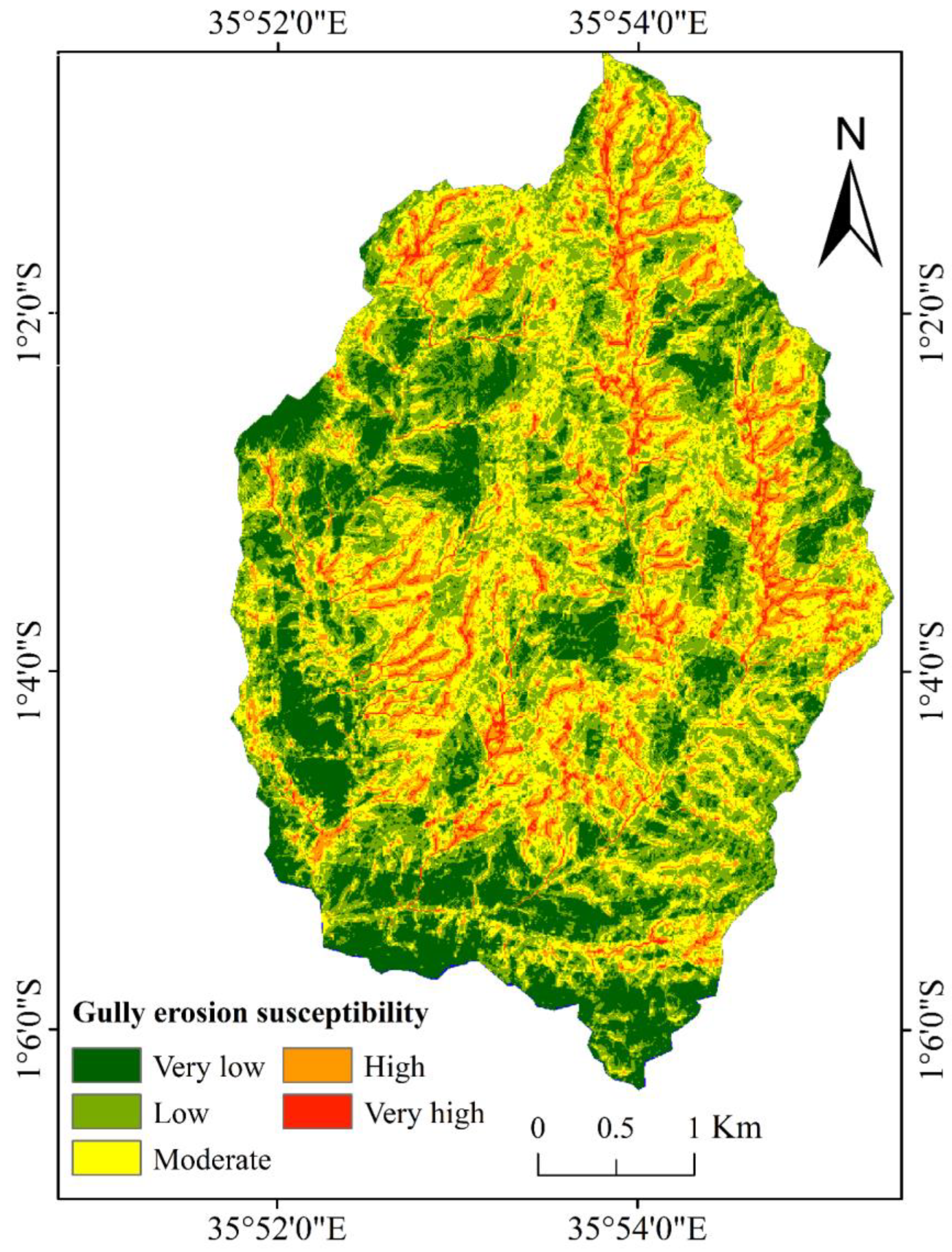
A gully erosion susceptibility map was created with the LR (Figure 8) and WoE–LR ensemble (Figure 9) using Equations (14) and (15), respectively, in ArcGIS interface and using the Jenks natural breaks classification method, reclassified into five classes (very low, low, moderate, high and very high) for visual interpretation.

3.3. Model Validation

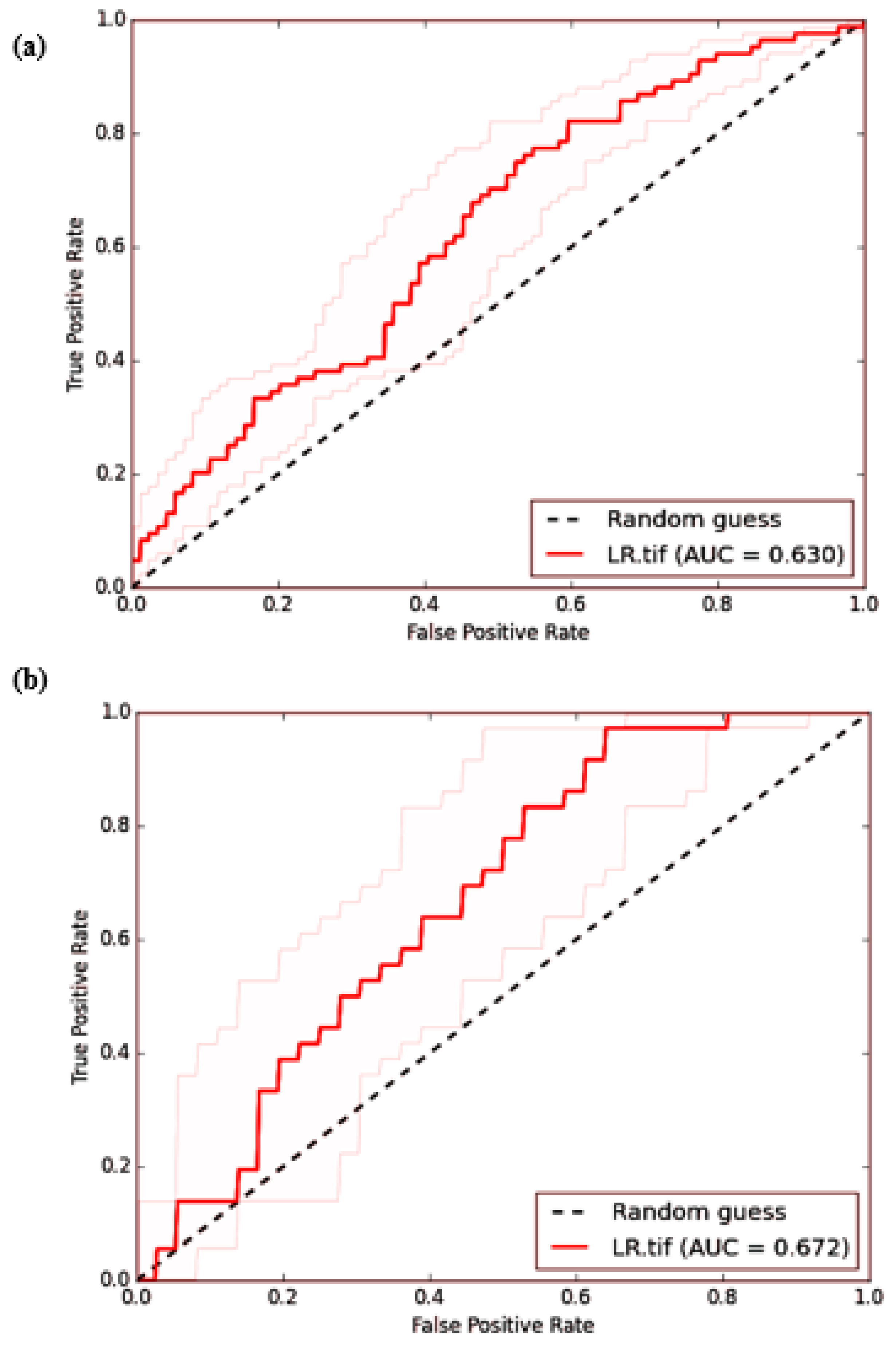
The model performance was evaluated by drawing the receiver operating characteristic (ROC) curve. A ROC of 1 indicates perfect prediction. The following is a classification of the relationship between prediction accuracy and AUC: 0.9–1 equals excellent; 0.8–0.9 equals very good; 0.7–0.8 equals good; 0.6–0.7 equals average; and 0.5–0.6 equals poor [55]. It was found that the WoE model has an accuracy of 62% during training and a validation accuracy of 67% as shown in Figure 10. This accuracy level is average but lower than that obtained by [5] of 79.5% and by [23] of 67.8%. The LR model has an accuracy of 63% and 67% during training and validation, respectively, as shown in Figure 11. The WoE–LR ensemble performed much better and had an accuracy of 88% during training and a validation accuracy of 78% as shown in Figure 12.

4. Discussion

Gully erosion has a two-fold impact on the environment: first, it degrades the surface and subsurface horizons of the soil, increasing the production of sediment, and second, it increases surface runoff and decreases groundwater recharge [61,62]. The first step in managing gully erosion is through gully erosion risk assessment that is conducted using gully erosion susceptibility models. Susceptibility maps can be helpful to government institutions, particularly since they can facilitate mitigation decisions for gully erosion [63]. In this research, three approaches along with the GIS technique were used for gully erosion susceptibility mapping: (1) using weight of evidence, (2) logistic regression and (3) their ensemble model. Using ROC curves and AUC values, the overall accuracy of the gully erosion susceptibility models was assessed.
In gully erosion investigations, it is critical to assess the significance of conditioning factors in gully susceptibility mapping. The results of the current study also showed that distance to roads, distance to streams, land use, TWI and STI are the most influential factors on gully occurrence. The output of the models reveals different gullying susceptibility value ranges. The results show that gully formation is more likely to develop in regions that are closer to roads and streams, have sparser vegetation and have higher drainage densities than other areas. These results are consistent with [17].
Maps showing gully erosion susceptibility classified areas of the basin with low slopes and close proximity to roads/paths as having high and extremely high susceptibility. In contrast, forest regions with steep slopes showed low susceptibility to gully erosion. In the forest, roughness due to vegetation cover may result in medium runoff factors in this area as well, resulting in a low concentrated flow force of degradation [63]. The outcomes further showed that the LR model’s prediction accuracy was improved by combining the WoE method with the LR approach. Therefore, rather than employing a single model that is tailored to each study area, it is crucial to assess the efficacy of a combination/ensemble of multiple models.

5. Conclusions and Recommendations

Gully erosion can lead to damage to the environment and agriculture lands thus leading to migration and less agricultural productivity. Many methods have recently been used to assess gully erosion susceptibility. In this paper, the WoE model and a proposed WoE–LR model were used to produce a gully erosion susceptibility map.
Nine conditioning factors were used including: slope, plan curvature, distance to streams (m), distance to roads (m), topographic position index (TPI), topographic wetness index (TWI), stream power index (SPI), sediment transport index (STI) and land use/land cover. Using the natural break method, the susceptibility maps were classified into five susceptibility classes (very low, low, moderate, high and very high). The WoE technique produced a map of areas susceptible to gully erosion with a prediction accuracy of 62% while the LR model and the WoE–LR ensemble had an accuracy of 63% and 88%, respectively.
These results show that an ensemble model performs better than an individual model. Amongst the conditioning factors, it was found that STI, land use/cover, TWI, distance to stream and distance to road had the most influence on the occurrence of gullies. The areas that were found to have low susceptibility include the forested areas and also near the already developed Narok town. The areas where agriculture is practiced and next to the roads were found to more susceptible to gully erosion.
The Kakia-Esamburmbur faces major land degradation due to loss of top fertile soil caused by water erosion. The susceptibility map can be used as a basic rule of thumb reference for land management in the Kakia-Esamburmbur catchment. The proposed ensemble model and gully erosion susceptibility map should be helpful to environmentalists and engineers for future planning and management.

Author Contributions

L.K.N.: Data curation, investigation, formal analysis, and original draft preparation; J.M.G.: funding acquisition, supervision, validation, resources, review and editing; J.K.K.: supervision, review and editing; C.K.C.: supervision, review and editing; A.P.: supervision, review and editing. All authors have read and agreed to the published version of the manuscript.

Funding

This research was funded by the Pan African University of Basic Sciences, Technology and Innovation (PAUSTI) and National Research Fund (NRF), Kenya (Flash Floods and Erosion in Enkare Narok Basin: Causes and Management).

Data Availability Statement

The data presented in this study are available on request from the corresponding author. The data are not publicly available due to privacy restrictions.

Acknowledgments

The authors acknowledge and appreciate the administrative and technical support from the Pan African University of Basic Sciences, Technology and Innovation (PAUSTI) and support of NRF project partners Water Resources Authority (WRA) and Ewaso Ng’iro South Development Authority (ENSDA).

Conflicts of Interest

The authors declare no conflict of interest. The funders had no role in the design of the study; in the collection, analyses, or interpretation of data; in the writing of the manuscript; or in the decision to publish the results.

References

  1. Arabameri, A.; Pradhan, B.; Pourghasemi, H.R.; Rezaei, K. Identification of erosion-prone areas using different multi-criteria decision-making techniques and gis. Geomat. Nat. Hazards Risk 2018, 9, 1129–1155. [Google Scholar] [CrossRef] [Green Version]
  2. Apollonio, C.; Petroselli, A.; Tauro, F.; Cecconi, M.; Biscarini, C.; Zarotti, C.; Grimaldi, S. Hillslope erosion mitigation: An experimental proof of a nature-based solution. Sustainability 2021, 13, 6058. [Google Scholar] [CrossRef]
  3. Sholagberu, A.T.; Mustafa, M.R.; Yusof, K.W.; Hashim, A.M. Geo-statistical based susceptibility mapping of soil erosion and optimization of its causative factors: A conceptual framework. J. Eng. Sci. Technol. 2017, 12, 2880–2895. [Google Scholar]
  4. Fox, G.A.; Sheshukov, A.; Cruse, R.; Kolar, R.L.; Guertault, L.; Gesch, K.R.; Dutnell, R.C. Reservoir Sedimentation and Upstream Sediment Sources: Perspectives and Future Research Needs on Streambank and Gully Erosion. Environ. Manag. 2016, 57, 945–955. [Google Scholar] [CrossRef] [Green Version]
  5. Zabihi, M.; Mirchooli, F.; Motevalli, A.; Darvishan, A.K.; Pourghasemi, H.R.; Zakeri, M.A.; Sadighi, F. Spatial modelling of gully erosion in Mazandaran Province, northern Iran. Catena 2018, 161, 1–13. [Google Scholar] [CrossRef]
  6. Odunuga, S.; Ajijola, A.; Igwetu, N.; Adegun, O. Land susceptibility to soil erosion in Orashi Catchment, Nnewi South, Anambra State, Nigeria. Proc. Int. Assoc. Hydrol. Sci. 2018, 376, 87–95. [Google Scholar] [CrossRef] [Green Version]
  7. Slimane, A.B.; Raclot, D.; Evrard, O.; Sanaa, M.; Lefevre, I.; Bissonnais, Y.L. Relative contribution of rill/interrill and gully/channel erosion to small reservoir siltation in mediterranean environments. Land Degrad. Dev. 2016, 27, 785–797. [Google Scholar]
  8. Issaka, S.; Ashraf, M.A. Impact of soil erosion and degradation on water quality: A review. Geol. Ecol. Landsc. 2017, 1, 1301053. [Google Scholar] [CrossRef] [Green Version]
  9. Borrelli, P.; Robinson, D.A.; Fleischer, L.R.; Lugato, E.; Ballabio, C.; Alewell, C.; Meusburger, K.; Modugno, S.; Schütt, B.; Ferro, V.; et al. An assessment of the global impact of 21st century land use change on soil erosion. Nat. Commun. 2017, 8, 1–13. [Google Scholar] [CrossRef] [Green Version]
  10. Hassen, G.; Bantider, A. Assessment of drivers and dynamics of gully erosion in case of Tabota Koromo and Koromo Danshe watersheds, South Central Ethiopia. Geoenviron. Disasters 2020, 7, 5. [Google Scholar] [CrossRef]
  11. Bui, D.T.; Shirzadi, A.; Shahabi, H.; Chapi, K.; Omidavr, E.; Pham, B.T.; Asl, D.T.; Khaledian, H.; Pradhan, B.; Panahi, M.; et al. A novel ensemble artificial intelligence approach for gully erosion mapping in a semi-arid watershed (Iran). Sensors 2019, 19, 2444. [Google Scholar] [CrossRef] [Green Version]
  12. Arabameri, A.; Pourghasemi, H.R. Spatial Modeling of Gully Erosion Using Linear and Quadratic Discriminant Analyses in GIS and R. In Spatial Modeling in GIS and R for Earth and Environmental Sciences; Elsevier: Amsterdam, The Netherlands, 2019; pp. 299–321. [Google Scholar] [CrossRef]
  13. Poesen, J.; Nachtergaele, J.; Verstraeten, G.; Valentin, C. Gully erosion and environmental change: Importance and research needs. Catena 2003, 50, 91–133. [Google Scholar] [CrossRef]
  14. Zakerinejad, R.; Maerker, M. An integrated assessment of soil erosion dynamics with special emphasis on gully erosion in the Mazayjan basin, southwestern Iran. Nat. Hazards 2015, 79, 25–50. [Google Scholar] [CrossRef]
  15. Arabameri, A.; Cerda, A.; Tiefenbacher, J.P. Spatial pattern analysis and prediction of gully erosion using novel hybrid model of entropy-weight of evidence. Water 2019, 11, 1129. [Google Scholar] [CrossRef] [Green Version]
  16. Angileri, S.E.; Conoscenti, C.; Hochschild, V.; Märker, M.; Rotigliano, E.; Agnesi, V. Water erosion susceptibility mapping by applying Stochastic Gradient Treeboost to the Imera Meridionale River Basin (Sicily, Italy). Geomorphology 2016, 262, 61–76. [Google Scholar] [CrossRef]
  17. Javidan, N.; Kavian, A.; Pourghasemi, H.R.; Conoscenti, C.; Jafarian, Z. Gully erosion susceptibility mapping using multivariate adaptive regression splines-replications and sample size scenarios. Water 2019, 11, 2319. [Google Scholar] [CrossRef] [Green Version]
  18. Conoscenti, C.; Angileri, S.; Cappadonia, C.; Rotigliano, E.; Agnesi, V.; Märker, M. Gully erosion susceptibility assessment by means of GIS-based logistic regression: A case of Sicily (Italy). Geomorphology 2014, 204, 399–411. [Google Scholar] [CrossRef] [Green Version]
  19. Han, F.; Ren, L.; Zhang, X.; Li, Z. The WEPP Model Application in a Small Watershed in the Loess Plateau. PLoS ONE 2016, 11, e0148445. [Google Scholar] [CrossRef] [Green Version]
  20. Langendoen, E.J.; Wells, R.R.; Ursic, M.E.; Vieira, D.A.N.; Dabney, S.M. Evaluating sediment transport capacity relationships for use in ephemeral gully erosion models. IAHS-AISH Proc. Rep. 2014, 367, 128–133. [Google Scholar] [CrossRef]
  21. Pourghasemi, H.R.; Yousefi, S.; Kornejady, A.; Cerdà, A. Performance assessment of individual and ensemble data-mining techniques for gully erosion modeling. Sci. Total Environ. 2017, 609, 764–775. [Google Scholar] [CrossRef] [Green Version]
  22. Wu, Z.; Wu, Y.; Yang, Y.; Chen, F.; Zhang, N.; Ke, Y.; Li, W. A comparative study on the landslide susceptibility mapping using logistic regression and statistical index models. Arab. J. Geosci. 2017, 10, 187. [Google Scholar] [CrossRef]
  23. Dube, F.; Nhapi, I.; Murwira, A.; Gumindoga, W.; Goldin, J.; Mashauri, D.A. Potential of weight of evidence modelling for gully erosion hazard assessment in Mbire District–Zimbabwe. Phys. Chem. Earth 2014, 67–69, 145–152. [Google Scholar] [CrossRef]
  24. Kornejady, A.; Ownegh, M.; Bahremand, A. Landslide susceptibility assessment using maximum entropy model with two different data sampling methods. Catena 2017, 152, 144–162. [Google Scholar] [CrossRef]
  25. Rahmati, O.; Haghizadeh, A.; Pourghasemi, H.R.; Noormohamadi, F. Gully erosion susceptibility mapping: The role of GIS-based bivariate statistical models and their comparison. Nat. Hazards 2016, 82, 1231–1258. [Google Scholar] [CrossRef]
  26. Rahmati, O.; Pourghasemi, H.R.; Melesse, A.M. Application of GIS-based data driven random forest and maximum entropy models for groundwater potential mapping: A case study at Mehran Region, Iran. Catena 2016, 137, 360–372. [Google Scholar] [CrossRef]
  27. Gómez-Gutiérrez, Á.; Conoscenti, C.; Angileri, S.E.; Rotigliano, E.; Schnabel, S. Using topographical attributes to evaluate gully erosion proneness (susceptibility) in two mediterranean basins: Advantages and limitations. Nat. Hazards 2015, 79, 291–314. [Google Scholar] [CrossRef]
  28. Jaafari, A.; Najafi, A.; Pourghasemi, H.R.; Rezaeian, J.; Sattarian, A. GIS-based frequency ratio and index of entropy models for landslide susceptibility assessment in the Caspian forest, northern Iran. Int. J. Environ. Sci. Technol. 2014, 11, 909–926. [Google Scholar] [CrossRef] [Green Version]
  29. Hong, H.; Chen, W.; Xu, C.; Youssef, A.M.; Pradhan, B.; Tien Bui, D. Rainfall-induced landslide susceptibility assessment at the Chongren area (China) using frequency ratio, certainty factor, and index of entropy. Geocarto Int. 2017, 32, 139–154. [Google Scholar] [CrossRef]
  30. Chen, W.; Pourghasemi, H.R.; Kornejady, A.; Zhang, N. Landslide spatial modeling: Introducing new ensembles of ANN, MaxEnt, and SVM machine learning techniques. Geoderma 2017, 305, 314–327. [Google Scholar] [CrossRef]
  31. Nhu, V.-H.; Mohammadi, A.; Shahabi, H.; Bin Ahmad, B.; Al-Ansari, N.; Shirzadi, A.; Clague, J.J.; Jaafari, A.; Chen, W.; Nguyen, H. Landslide Susceptibility Mapping Using Machine Learning Algorithms and Remote Sensing Data in a Tropical Environment. Int. J. Environ. Res. Public Health 2020, 17, 4933. [Google Scholar]
  32. Chen, W.; Li, H.; Hou, E.; Wang, S.; Wang, G.; Panahi, M.; Li, T.; Peng, T.; Guo, C.; Niu, C.; et al. GIS-based groundwater potential analysis using novel ensemble weights-of-evidence with logistic regression and functional tree models. Sci. Total Environ. 2018, 634, 853–867. [Google Scholar] [CrossRef] [Green Version]
  33. Roodposhti, M.S.; Safarrad, T.; Shahabi, H. Drought sensitivity mapping using two one-class support vector machine algorithms. Atmos. Res. 2017, 193, 73–82. [Google Scholar] [CrossRef]
  34. Shafizadeh-Moghadam, H.; Valavi, R.; Shahabi, H.; Chapi, K.; Shirzadi, A. Novel forecasting approaches using combination of machine learning and statistical models for flood susceptibility mapping. J. Environ. Manag. 2018, 217, 1–11. [Google Scholar] [CrossRef] [Green Version]
  35. Kadavi, P.R.; Lee, C.W.; Lee, S. Application of ensemble-based machine learning models to landslide susceptibility mapping. Remote Sens. 2018, 10, 1252. [Google Scholar] [CrossRef] [Green Version]
  36. Tehrany, M.S.; Pradhan, B.; Jebur, M.N. Flood susceptibility mapping using a novel ensemble weights-of-evidence and support vector machine models in GIS. J. Hydrol. 2014, 512, 332–343. [Google Scholar] [CrossRef]
  37. Tchouateu, O.T.; Mwangi, H.M.; Sang, J.K.; Ngugi, H.N. Impacts of climate change on peak streamflow in Kakia-Esamburmbur Sub-catchment of Enkare Narok River catchment, Kenya. J. Sustain. Res. Eng. 2020, 5, 194–205. [Google Scholar]
  38. Mireille, N.M.; Mwangi, H.M.; Mwangi, J.K.; Gathenya, J.M. Analysis of Land Use Change and Its Impact on the Hydrology of Kakia and Esamburmbur of the. Hydrology 2019, 6, 86. [Google Scholar] [CrossRef] [Green Version]
  39. Umukiza, E.; Raude, J.M.; Wandera, S.M.; Petroselli, A.; Gathenya, J.M. Impacts of Land Use and Land Cover Changes on Peak Discharge and Flow Volume in Kakia and Esamburmbur Sub-Catchments of Narok Town, Kenya. Hydrology 2021, 8, 82. [Google Scholar] [CrossRef]
  40. Rahmati, O.; Tahmasebipour, N.; Haghizadeh, A.; Pourghasemi, H.R.; Feizizadeh, B. Evaluation of different machine learning models for predicting and mapping the susceptibility of gully erosion. Geomorphology 2017, 298, 118–137. [Google Scholar] [CrossRef]
  41. Lombardo, L.; Cama, M.; Maerker, M.; Rotigliano, E. A test of transferability for landslides susceptibility models under extreme climatic events: Application to the Messina 2009 disaster. Nat. Hazards 2014, 74, 1951–1989. [Google Scholar] [CrossRef]
  42. Alaska Satellite Facility Data Search Vertex (2020). Available online: https://search.asf.alaska.edu/#/?dataset=ALOS (accessed on 29 January 2023).
  43. Arabameri, A.; Chen, W.; Loche, M.; Zhao, X.; Li, Y.; Lombardo, L.; Cerda, A.; Pradhan, B.; Bui, D.T. Comparison of machine learning models for gully erosion susceptibility mapping. Geosci. Front. 2019, 11, 1609–1620. [Google Scholar] [CrossRef]
  44. Hu, C.; Wright, A.L.; Lian, G. Estimating the Spatial Distribution of Soil Properties Using Environmental Variables at a Catchment Scale in the Loess Hilly Area, China. Int. J. Environ. Res. Public Heal. 2019, 16, 491. [Google Scholar] [CrossRef] [Green Version]
  45. Trigila, A.; Iadanza, C.; Esposito, C.; Scarascia-Mugnozza, G. Comparison of Logistic Regression and Random Forests techniques for shallow landslide susceptibility assessment in Giampilieri (NE Sicily, Italy). Geomorphology 2015, 249, 119–136. [Google Scholar] [CrossRef]
  46. Jenness, J. Topographic Position Index (tpi_jen.avx) Extension for ArcView 3.x, v. 1.2. Jenness Enterprises. 2006. Available online: http://www.jennessent.com/arcview/tpi.htm (accessed on 1 March 2023).
  47. Chen, W.; Pourghasemi, H.R.; Naghibi, S.A. Prioritization of landslide conditioning factors and its spatial modeling in Shangnan County, China using GIS-based data mining algorithms. Bull. Eng. Geol. Environ. 2018, 77, 611–629. [Google Scholar] [CrossRef]
  48. Meinhardt, M.; Fink, M.; Tünschel, H. Landslide susceptibility analysis in central Vietnam based on an incomplete landslide inventory: Comparison of a new method to calculate weighting factors by means of bivariate statistics. Geomorphology 2015, 234, 80–97. [Google Scholar] [CrossRef]
  49. Copernicus. Available online: https://scihub.copernicus.eu/ (accessed on 31 August 2020).
  50. Ozdemir, A. Using a binary logistic regression method and GIS for evaluating and mapping the groundwater spring potential in the Sultan Mountains (Aksehir, Turkey). J. Hydrol. 2011, 405, 123–136. [Google Scholar] [CrossRef]
  51. Chen, W.; Sun, Z.; Han, J. Landslide susceptibility modeling using integrated ensemble weights of evidence with logistic regression and random forest models. Appl. Sci. 2019, 9, 171. [Google Scholar] [CrossRef] [Green Version]
  52. Pourghasemi, H.R.; Moradi, H.R.; Fatemi Aghda, S.M. Landslide susceptibility mapping by binary logistic regression, analytical hierarchy process, and statistical index models and assessment of their performances. Nat. Hazards 2013, 69, 749–779. [Google Scholar] [CrossRef]
  53. Xu, C.; Xu, X.; Dai, F.; Xiao, J.; Tan, X.; Yuan, R. Landslide hazard mapping using GIS and weight of evidence model in Qingshui River watershed of 2008 Wenchuan earthquake struck region. J. Earth Sci. 2012, 23, 97–120. [Google Scholar] [CrossRef]
  54. Shit, P.K.; Bhunia, G.S.; Pourghasemi, H.R. Gully Erosion Susceptibility Mapping Based on Bayesian Weight of Evidence. Adv. Sci. Technol. Innov. 2020, 8, 133–146. [Google Scholar] [CrossRef]
  55. Chen, W.; Reza, H.; Seyed, P.; Naghibi, A. A comparative study of landslide susceptibility maps produced using support vector machine with different kernel functions and entropy data mining models in China. Bull. Eng. Geol. Environ. 2018, 77, 647–664. [Google Scholar] [CrossRef]
  56. Youssef, A.M.; Pourghasemi, H.R.; Pourtaghi, Z.S.; Al-Katheeri, M.M. Landslide susceptibility mapping using random forest, boosted regression tree, classification and regression tree, and general linear models and comparison of their performance at Wadi Tayyah Basin, Asir Region, Saudi Arabia. Landslides Landslides 2015, 13, 839–856. [Google Scholar] [CrossRef]
  57. Pourtaghi, Z.S.; Pourghasemi, H.R.; Rossi, M. Erratum to: Forest fire susceptibility mapping in the Minudasht forests, Golestan province, Iran. Environ. Earth Sci. 2015, 73, 1535. [Google Scholar] [CrossRef] [Green Version]
  58. Meliho, M.; Khattabi, A.; Mhammdi, N. A GIS-based approach for gully erosion susceptibility modelling using bivariate statistics methods in the Ourika watershed, Morocco. Environ. Earth Sci. 2018, 77, 655. [Google Scholar] [CrossRef]
  59. Mukai, S. Gully Erosion Rates and Analysis of Determining Factors: A Case Study from the Semi-arid Main Ethiopian Rift Valley. Land Degrad. Dev. 2016, 28, 602–615. [Google Scholar] [CrossRef]
  60. Chuma, G.B.; Mondo, J.M.; Ndeko, A.B.; Mugumaarhahama, Y.; Bagula, E.M.; Blaise, M.; Valérie, M.; Jacques, K.; Karume, K.; Mushagalusa, G.N. Forest cover affects gully expansion at the tropical watershed scale: Case study of Luzinzi in Eastern DR Congo. Trees For. People 2021, 4, 100083. [Google Scholar] [CrossRef]
  61. Kou, M.; Jiao, J.; Yin, Q.; Wang, N.; Wang, Z.; Li, Y.; Yu, W.; Wei, Y.; Yan, F.; Cao, B. Successional Trajectory Over 10Years of Vegetation Restoration of Abandoned Slope Croplands in the Hill-Gully Region of the Loess Plateau. Land Degrad. Dev. 2016, 27, 919–932. [Google Scholar] [CrossRef]
  62. Azareh, A.; Rahmati, O.; Rafiei-Sardooi, E.; Sankey, J.B.; Lee, S.; Shahabi, H.; Ahmad, B. Modelling gully-erosion susceptibility in a semi-arid region, Iran: Investigation of applicability of certainty factor and maximum entropy models. Sci. Total Environ. 2019, 655, 684–696. [Google Scholar] [CrossRef]
  63. Arabameri, A.; Pradhan, B.; Bui, D.T. Spatial modelling of gully erosion in the Ardib River Watershed using three statistical-based techniques. Catena 2020, 190, 104545. [Google Scholar] [CrossRef]
Figure 1. Map of Kakia-Esamburmbur catchment showing the training and testing datasets for modeling.
Water 15 01292 g001
Figure 2. Flowchart for the research methodology on gully erosion susceptibility mapping in Kakia-Esamburmbur catchment, Narok.
Water 15 01292 g002
Figure 3. Map of the observed gullies (a) and pictures of some of the gullies identified in the Kakia-Esamburmbur catchment (b,c).
Water 15 01292 g003
Figure 4. Gully erosion conditioning factors: (a) slope (percent), (b) curvature, (c) topographic wetness index (TWI) and (d) distance to stream/channel.
Water 15 01292 g004
Figure 5. Gully erosion conditioning factors: (a) distance to road, (b) topographic position index (TPI), (c) stream power index (SPI) and (d) sediment transport index (STI).
Water 15 01292 g005
Figure 6. Gully erosion conditioning factors: land use/cover.
Water 15 01292 g006
Figure 7. Map of gully erosion susceptibility of Kakia-Esamburmbur catchment using WoE.
Water 15 01292 g007
Figure 8. Map of gully erosion susceptibility of Kakia-Esamburmbur catchment using LR.
Water 15 01292 g008
Figure 9. Map of gully erosion susceptibility of Kakia-Esamburmbur catchment using WoE–LR.
Water 15 01292 g009
Figure 10. Prediction rate curve for gully erosion susceptibility map using WoE in Kakia-Esamburmbur catchment: (a) training and (b) validation.
Water 15 01292 g010
Figure 11. Prediction rate curve for gully erosion susceptibility map using LR in Kakia-Esamburmbur catchment: (a) training and (b) validation.
Water 15 01292 g011
Figure 12. Prediction rate curve for gully erosion susceptibility map using WoE–LR in Kakia-Esamburmbur catchment: (a) training and (b) validation.
Water 15 01292 g012
Table 1. Multicollinearity test statistics of gully conditioning factors.
ParameterCollinearity statistics
ToleranceVIF
Curvature0.851.17
Distance to road0.831.20
Distance to stream0.921.09
Landcover0.941.06
Slope0.881.14
SPI0.961.04
STI0.412.41
TPI0.881.14
TWI0.402.49
Table 2. Weights of conditioning factors Slope, Curvature, TWI, Distance to stream and Distance to road as analyzed using WoE method.
FactorsClassW+W-Wfinal
Slope (%)0–4.4−0.88520.0099−0.8951
4.5–8.1−0.55590.0441−0.6000
8.2–11.2−0.33760.0359−0.3735
11.3–16.0−0.21150.1523−0.3638
16.1–42.10.4138−0.34410.7579
CurvatureConcave−0.13190.0420−0.1739
flat0.1961−0.22730.4233
convex−0.33270.0938−0.4266
TWI3–6.1−0.42930.2090−0.6383
6.1–7.7−0.19820.0832−0.2814
7.7–9.60.0501−0.01050.0606
9.6–11.80.4188−0.04410.4629
11.8–18.71.8308−0.16721.9979
Distance to stream (m)0–38−0.21490.2410−0.4559
38–89−0.63710.1579−0.7949
89–1501.3807−0.35031.7310
150–224−0.78610.0261−0.8122
224–539−0.53840.0051−0.5434
Distance to road (m)0–2043.8957−0.24294.1387
204–4340.5204−0.05210.5725
434–683−0.75370.1270−0.8807
683–959−0.93060.2262−1.1568
959–15110.0563−0.04420.1005
Note: W+ is positive weight, W is negative weight, Wfinal is W+ − W.
Table 3. Weights of conditioning factors TPI, SPI, STI, LULC as analyzed using WoE method.
FactorsClassW+WWfinal
TPI−6.8–−1.50.4019−0.04270.4446
−1.5–−0.50.2975−0.10210.3996
−0.5–0.50.0118−0.00670.0185
0.5–1.6−0.30650.0890−0.3955
1.6–7.1−0.89780.0529−0.9507
SPI0–160−0.11221.3792−1.4915
160–750−1.38330.0208−1.4041
750–19252.1774−0.04372.2211
1925–41203.9965−0.07694.0735
4120–136402.9584−0.00652.9649
STI0–4−0.13400.6750−0.8090
4–110.2549−0.02540.2803
11–271.0322−0.05111.0834
27–601.7170−0.03461.7516
60–2471.7125−0.00561.7181
LULCTrees−1.33750.0196−1.3570
Shrubs−0.95760.0343−0.9918
Grassland−0.88270.0098−0.8925
Cropland0.1143−1.05171.1660
Vegetation aquatic/regularly flooded3.1360−0.00663.1425
Bare4.0024−0.00674.0091
Built-up areas−2.17440.0553−2.2296
Note: W+ is positive weight, and W is negative weight, Wfinal is W+ − W.
Table 4. Significance levels of the conditioning factors.
EstimateStandard ErrorZ ValuePr (>|z|)
(Intercept)−7.025994741.6681−0.0090.99244
Curvature−0.0035450.002803−1.2650.20593
Distance to road0.006770.0016054.2182.46 × 10−5***
Distance to stream0.0026530.0015441.7190.08569.
Land use/cover0.0078040.0036422.1430.03214*
Slope0.0040480.006340.6390.52313
SPI0.0081140.0302440.2680.78847
STI−0.0232670.006674−3.4860.00049***
TPI−0.001940.002445−0.7930.42765
TWI0.0610950.0142134.2991.72 × 10−5***
Note: Significance codes: ‘***’ 0.001 ‘*’ 0.05 ‘.’ 0.1.
Disclaimer/Publisher’s Note: The statements, opinions and data contained in all publications are solely those of the individual author(s) and contributor(s) and not of MDPI and/or the editor(s). MDPI and/or the editor(s) disclaim responsibility for any injury to people or property resulting from any ideas, methods, instructions or products referred to in the content.