
Mapping of Areas Vulnerable to Flash Floods by Means of Morphometric Analysis with Weighting Criteria Applied
 , , , and
Abstract
1. Introduction
2. Materials and Methods
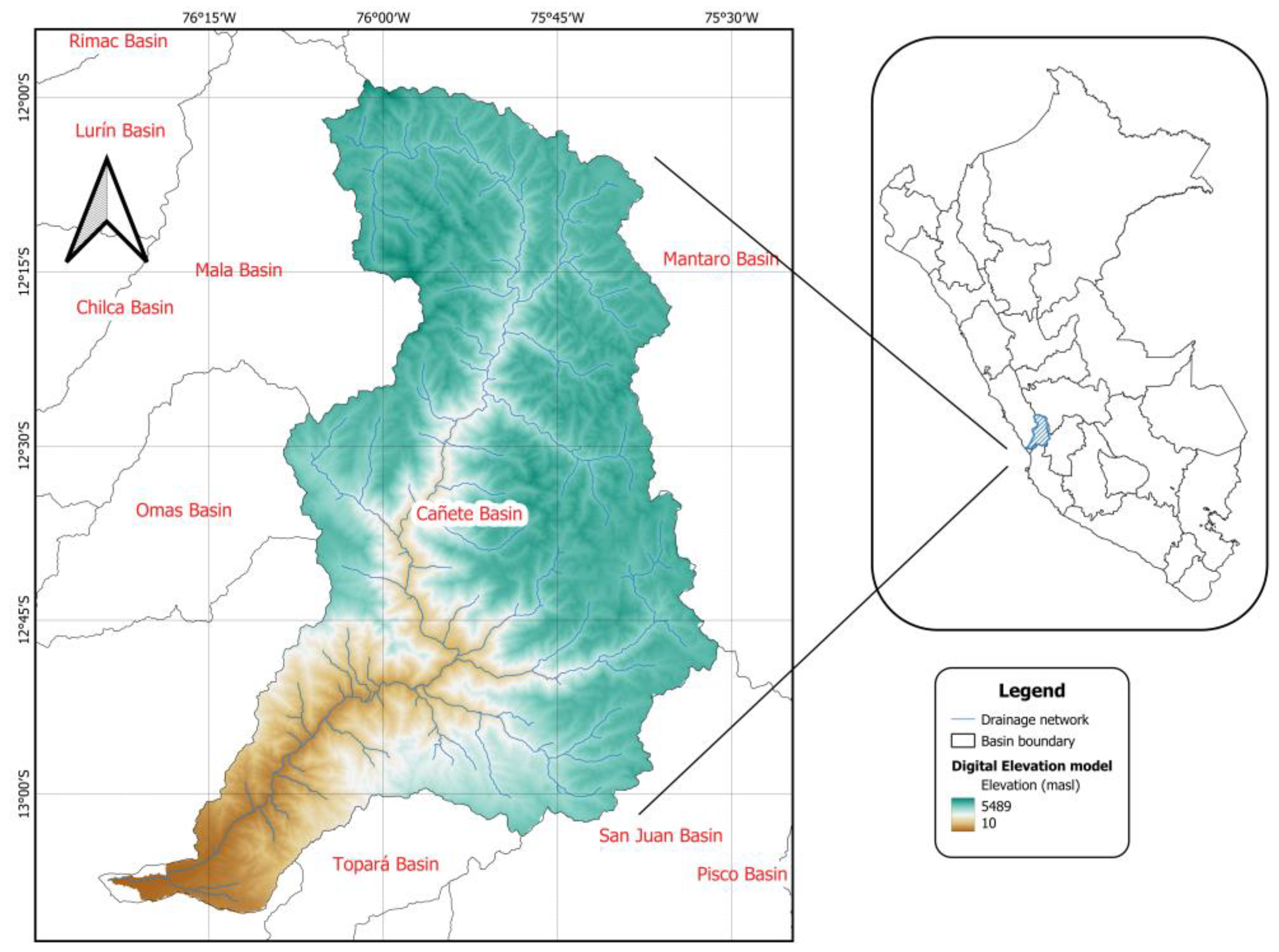
2.1. Study Area
2.2. Morphometric Parameters
2.3. Data Used
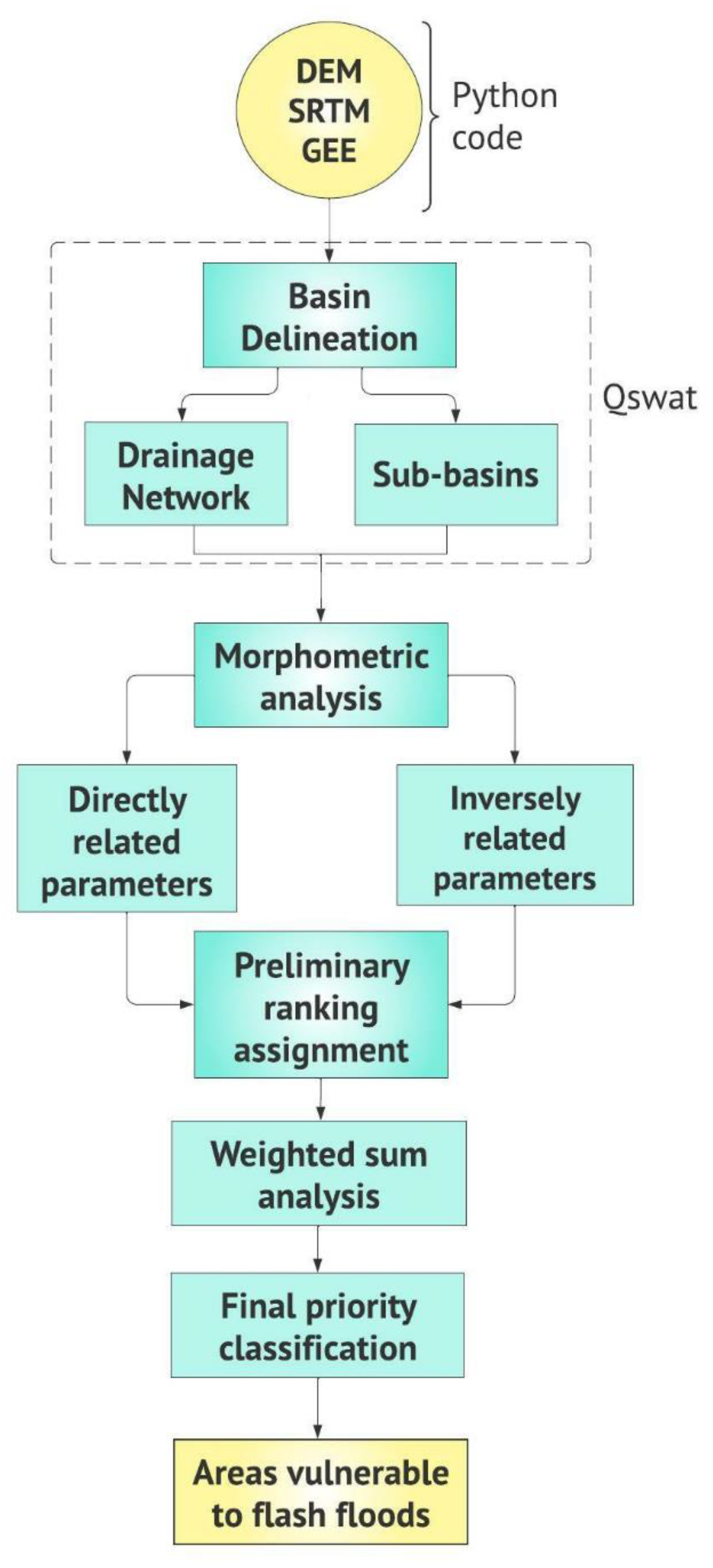
2.4. Methodology
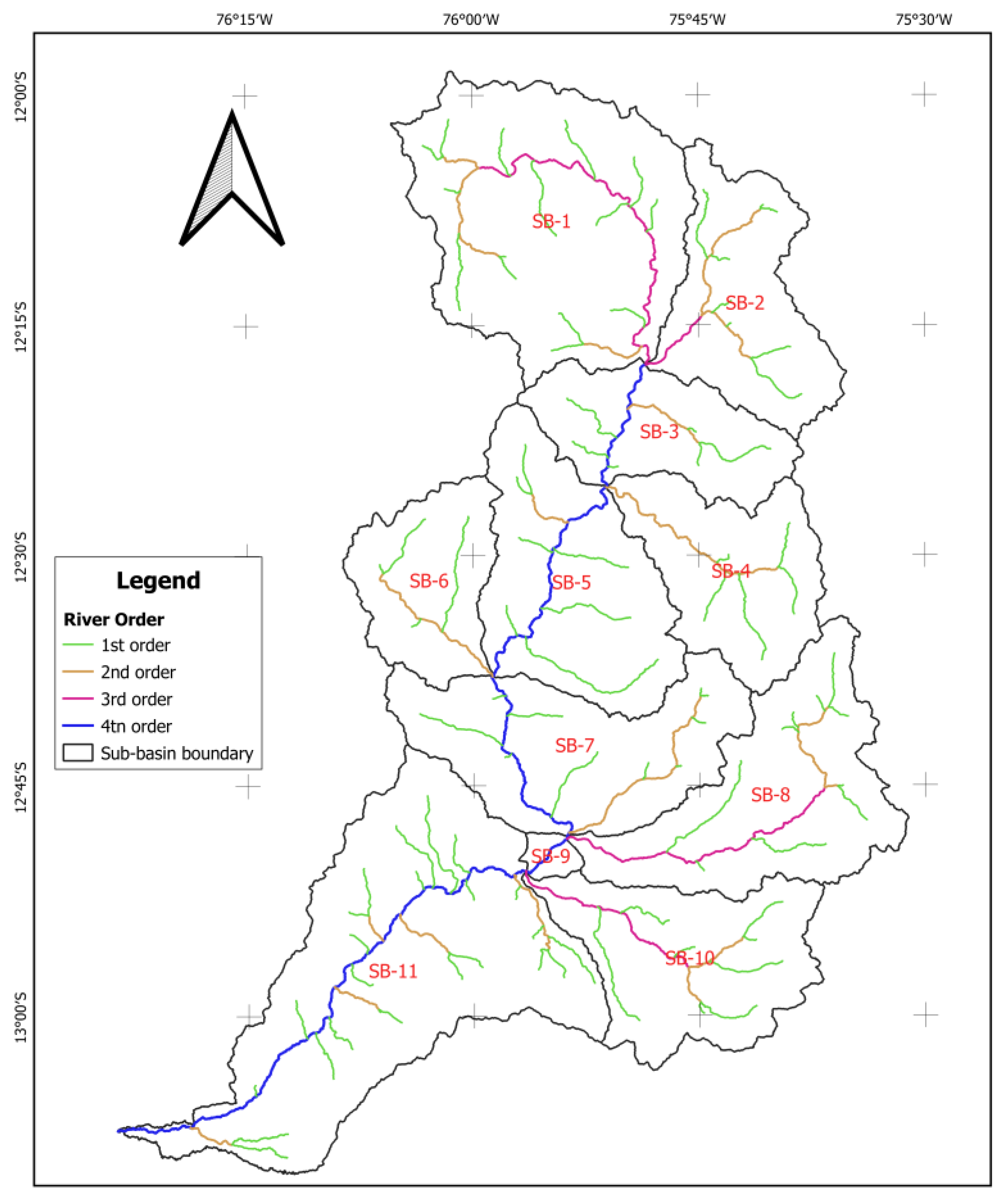
2.4.1. Extraction of Drainage Network and Sub-Basin Delineation
2.4.2. Morphometric Analysis
2.4.3. Preliminary Ranking of Sub-Basin Priority
2.4.4. Weighted Sum Analysis and Final Ranking
3. Results and Discussion
3.1. Morphometric Analysis of the Basin
3.2. Assignment of Preliminary Sub-Basin Priority Rankings
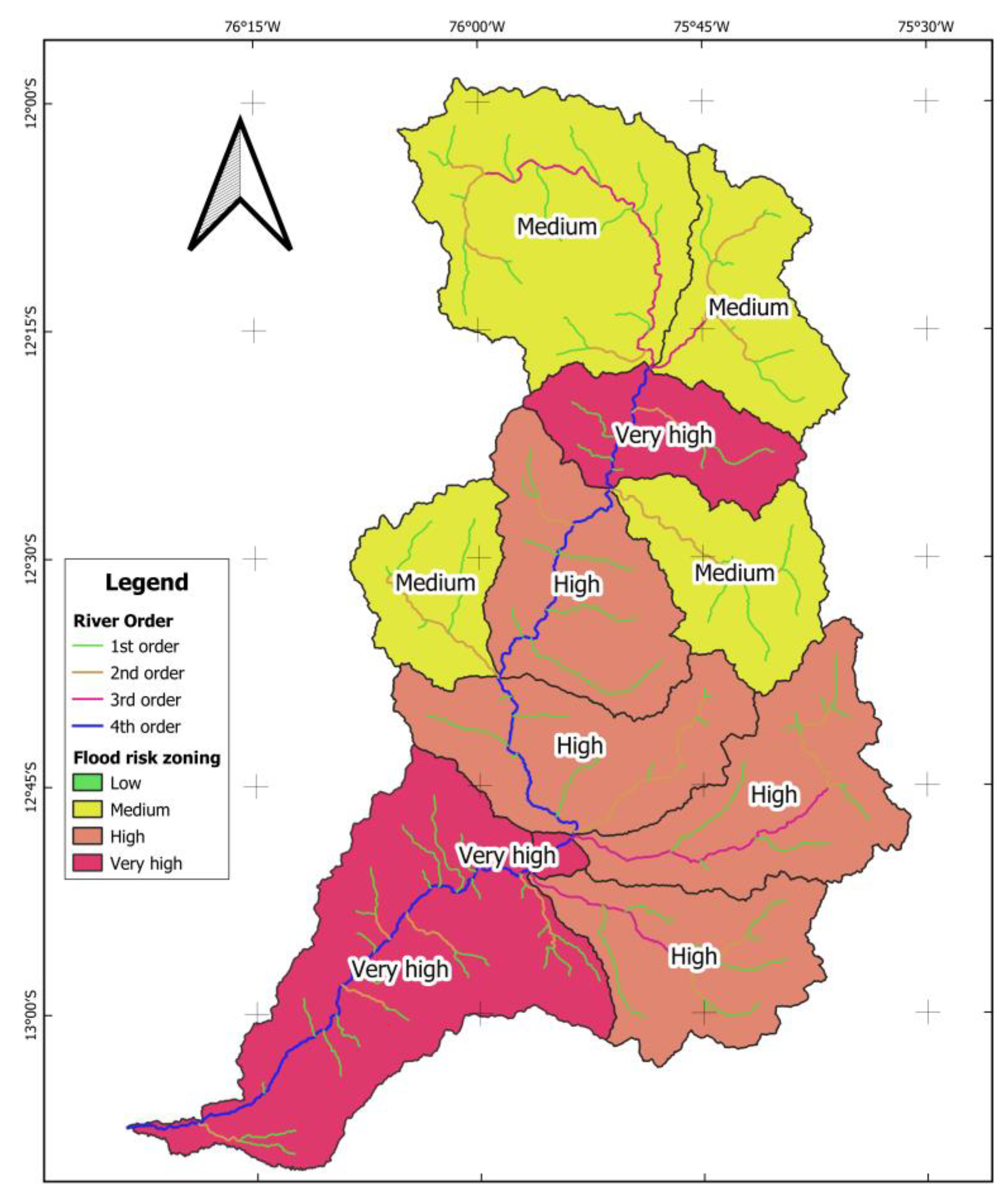
3.3. Final Ranking Using Weighted Sum Analysis
4. Conclusions
Supplementary Materials
Author Contributions
Funding
Data Availability Statement
Acknowledgments
Conflicts of Interest
References
- Bisht, S.; Chaudhry, S.; Sharma, S.; Soni, S. Assessment of flash flood vulnerability zonation through Geospatial technique in high altitude Himalayan watershed, Himachal Pradesh India. Remote Sens. Appl. Soc. Environ. 2018, 12, 35–47. [Google Scholar] [CrossRef]
- Cahyono, C.; Adidarma, W.K. Influence analysis of peak rate factor in the flood events’ calibration process using HEC-HMS. Model. Earth Syst. Environ. 2019, 5, 1705–1722. [Google Scholar] [CrossRef]
- Teng, F.; Huang, W.; Ginis, I. Hydrological modeling of storm runoff and snowmelt in Taunton River Basin by applications of HEC-HMS and PRMS models. Nat. Hazards 2018, 91, 179–199. [Google Scholar] [CrossRef]
- Wang, N.; Lombardo, L.; Gariano, S.L.; Cheng, W.; Liu, C.; Xiong, J.; Wang, R. Using satellite rainfall products to assess the triggering conditions for hydro-morphological processes in different geomorphological settings in China. Int. J. Appl. Earth Obs. Geoinf. 2021, 102, 102350. [Google Scholar] [CrossRef]
- Prakash, K.; Rawat, D.; Singh, S.; Chaubey, K.; Kanhaiya, S.; Mohanty, T. Morphometric analysis using SRTM and GIS in synergy with depiction: A case study of the Karmanasa River basin, North central India. Appl. Water Sci. 2019, 9, 13. [Google Scholar] [CrossRef]
- Perucca, L.P.; Esper Angilieri, Y. Morphometric characterization of del Molle Basin applied to the evaluation of flash floods hazard, Iglesia Department, San Juan, Argentina. Quat. Int. 2011, 233, 81–86. [Google Scholar] [CrossRef]
- Rai, P.K.; Singh, P.; Mishra, V.N.; Singh, A.; Sajan, V.; Shahi, A.P. Geospatial approach for quantitative drainage morphometric analysis of Varuna river basin, India. J. Landsc. Ecol. 2019, 12, 1–25. [Google Scholar] [CrossRef]
- Rai, P.K.; Chandel, R.S.; Mishra, V.N.; Singh, P. Hydrological inferences through morphometric analysis of lower Kosi river basin of India for water resource management based on remote sensing data. Appl. Water Sci. 2018, 8, 15. [Google Scholar] [CrossRef]
- Aher, P.; Adinarayana, J.; Gorantiwar, S. Quantification of morphometric characterization and prioritization for management planning in semi-arid tropics of India: A remote sensing and GIS approach. J. Hydrol. 2014, 511, 850–860. [Google Scholar] [CrossRef]
- Shivhare, V.; Gupta, C.; Mallick, J.; Singh, C.K. Geospatial modelling for sub-watershed prioritization in Western Himalayan Basin using morphometric parameters. Nat. Hazards 2022, 110, 545–561. [Google Scholar] [CrossRef]
- Abdeta, G.C.; Tesemma, A.B.; Tura, A.L.; Atlabachew, G.H. Morphometric analysis for prioritizing sub-watersheds and management planning and practices in Gidabo Basin, Southern Rift Valley of Ethiopia. Appl. Water Sci. 2020, 10, 158. [Google Scholar] [CrossRef]
- Waiyasusri, K.; Chotpantarat, S. Watershed Prioritization of Kaeng Lawa Sub-Watershed, Khon Kaen Province Using the Morphometric and Land-Use Analysis: A Case Study of Heavy Flooding Caused by Tropical Storm Podul. Water 2020, 12, 1570. [Google Scholar] [CrossRef]
- Ahirwar, R.; Malik, M.S.; Shukla, J.P. Prioritization of Sub-Watersheds for Soil and Water Conservation in Parts of Narmada River through Morphometric Analysis Using Remote Sensing and GIS. J. Geol. Soc. India 2019, 94, 515–524. [Google Scholar] [CrossRef]
- Anees, M.T.; Abdullah, K.; Nawawi, M.; Rahman, N.N.N.A.; Ismail, A.Z.; Syakir, M.; Abdul Kadir, V. Prioritization of Flood Vulnerability Zones Using Remote Sensing and GIS for Hydrological Modelling. Irrig. Drain. 2019, 68, 176–190. [Google Scholar] [CrossRef]
- Chauhan, P.; Chauniyal, D.D.; Singh, N.; Tiwari, R.K. Quantitative geo-morphometric and land cover-based micro-watershed prioritization in the Tons river basin of the lesser Himalaya. Environ. Earth Sci. 2016, 75, 498. [Google Scholar] [CrossRef]
- Singh, G.; Pandey, A. Morphometric Characterization and Flash Flood Zonation of a Mountainous Catchment Using Weighted Sum Approach. In Geospatial Technologies for Land and Water Resources Management; Pandey, A., Chowdary, V.M., Behera, M.D., Singh, V.P., Eds.; Springer International Publishing: Berlin/Heidelberg, Germany, 2022; pp. 409–428. [Google Scholar] [CrossRef]
- El-Fakharany, M.A.; Hegazy, M.N.; Mansour, N.M.; Abdo, A.M. Flash flood hazard assessment and prioritization of sub-watersheds in Heliopolis basin, East Cairo, Egypt. Arab. J. Geosci. 2021, 14, 1693. [Google Scholar] [CrossRef]
- Jothimani, M.; Abebe, V.; Dawit, Z. Mapping of soil erosion-prone sub-watersheds through drainage morphometric analysis and weighted sum approach: A case study of the Kulfo River basin, Rift valley, Arba Minch, Southern Ethiopia. Model. Earth Syst. Environ. 2020, 6, 2377–2389. [Google Scholar] [CrossRef]
- Mahmood, S.; Rahman, A. Flash flood susceptibility modeling using geo-morphometric and hydrological approaches in Panjkora Basin, Eastern Hindu Kush, Pakistan. Environ. Earth Sci. 2019, 78, 43. [Google Scholar] [CrossRef]
- Mahmood, S.; Rahman, A. Flash flood susceptibility modelling using geomorphometric approach in the Ushairy Basin, eastern Hindu Kush. J. Earth Syst. Sci. 2019, 128, 97. [Google Scholar] [CrossRef]
- Khan, I.; Bali, R.; Agarwal, K.K.; Kumar, D.; Singh, S.K. Morphometric Analysis of Parvati Basin, NW Himalaya: A Remote Sensing and GIS Based Approach. J. Geol. Soc. India 2021, 97, 165–172. [Google Scholar] [CrossRef]
- Malik, A.; Kumar, A.; Kandpal, H. Morphometric analysis and prioritization of sub-watersheds in a hilly watershed using weighted sum approach. Arab. J. Geosci. 2019, 12, 118. [Google Scholar] [CrossRef]
- Sakthivel, R.; Jawahar Raj, N.; Sivasankar, V.; Akhila, P.; Omine, K. Geo-spatial technique-based approach on drainage morphometric analysis at Kalrayan Hills, Tamil Nadu, India. Appl. Water Sci. 2019, 9, 24. [Google Scholar] [CrossRef]
- Prasad, R.N.; Pani, P. Geo-hydrological analysis and sub watershed prioritization for flash flood risk using weighted sum model and snyder’s synthetic unit hydrograph. Model. Earth Syst. Environ. 2017, 3, 1491–1502. [Google Scholar] [CrossRef]
- Prakash, K.; Mohanty, T.; Singh, S.; Chaubey, K.; Prakash, P. Drainage morphometry of the Dhasan river basin, Bundelkhand craton, central India using remote sensing and GIS techniques. J. Geomat. 2016, 10, 122–132. [Google Scholar]
- Kumar, A.; Singh, S.; Pramanik, M.; Chaudhary, S.; Maurya, A.K.; Kumar, M. Watershed prioritization for soil erosion mapping in the Lesser Himalayan Indian basin using PCA and WSA methods in conjunction with morphometric parameters and GIS-based approach. Environ. Dev. Sustain. 2022, 24, 3723–3761. [Google Scholar] [CrossRef]
- Rahman, M.M.; Zaman, M.N.; Biswas, P.K. Optimization of significant morphometric parameters and sub-watershed prioritization using PCA and PCA-WSM for soil conservation: A case study in dharla River watershed, Bangladesh. Model. Earth Syst. Environ. 2022, 8, 2661–2674. [Google Scholar] [CrossRef]
- Malik, A.; Kumar, A.; Kushwaha, D.P.; Kisi, O.; Salih, S.Q.; Al-Ansari, N.; Yaseen, Z.M. The Implementation of a Hybrid Model for Hilly Sub-Watershed Prioritization Using Morphometric Variables: Case Study in India. Water 2019, 11, 1505–1519. [Google Scholar] [CrossRef]
- Meshram, S.G.; Sharma, S.K. Prioritization of watershed through morphometric parameters: A PCA-based approach. Appl. Water Sci. 2017, 7, 1505–1519. [Google Scholar] [CrossRef]
- Meshram, S.G.; Alvandi, E.; Meshram, C.; Kahya, E.; Fadhil Al-Quraishi, A.M. Application of SAW and TOPSIS in Prioritizing Watersheds. Water Resour. Manag. 2020, 34, 715–732. [Google Scholar] [CrossRef]
- CARE-Perú. Modelización Hidrológica de la Cuenca Cañete y Evaluación del Impacto del Cambio Climático; CARE-Perú: Lima, Peru, 2018. [Google Scholar]
- Portuguez-Maurtua, M. Aplicación de la geoestadística a modelos hidrológicos en la cuenca del río Cañete. Master’s Thesis, Universidad Nacional Agraria La Molina, Lima, Peru, 2017. [Google Scholar]
- Arulbalaji, P.; Padmalal, D. Sub-watershed Prioritization Based on Drainage Morphometric Analysis: A Case Study of Cauvery River Basin in South India. J. Geol. Soc. India 2020, 95, 25–35. [Google Scholar] [CrossRef]
- Meraj, G.; Romshoo, S.A.; Yousuf, A.R.; Altaf, S.; Altaf, F. Assessing the influence of watershed characteristics on the flood vulnerability of Jhelum basin in Kashmir Himalaya. Nat. Hazards 2015, 77, 153–175. [Google Scholar] [CrossRef]
- Gajbhiye, S.; Mishra, S.K.; Pandey, A. Prioritizing erosion-prone area through morphometric analysis: An RS and GIS perspective. Appl. Water Sci. 2014, 4, 51–61. [Google Scholar] [CrossRef]
- Odiji, C.A.; Aderoju, O.M.; Eta, J.B.; Shehu, I.; Mai-Bukar, A.; Onuoha, H. Morphometric analysis and prioritization of upper benue river watershed. Appl. Water Sci. 2021, 11, 41. [Google Scholar] [CrossRef]
- Strahler, A. Quantitative Geomorphology of Drainage Basin and Channel Networks. In Handbook of Applied Hydrology; McGraw-Hill: New York, NY, USA, 1964. [Google Scholar]
- Horton, R.E. Erosional development of streams and their drainage basins; hydrophysical approach to quantitative morphology. Geol. Soc. Am. Bull. 1945, 56, 275–370. [Google Scholar] [CrossRef]
- Nooka Ratnam, K.; Srivastava, Y.; Venkateswara Rao, V.; Amminedu, E.; Murthy, K. Check dam positioning by prioritization of micro-watersheds using SYI model and morphometric analysis remote sensing and GIS perspective. J. Indian Soc. Remote Sens. 2005, 33, 25–38. [Google Scholar] [CrossRef]
- Sreedevi, P.D.; Sreekanth, P.D.; Khan, H.H.; Ahmed, S. Drainage morphometry and its influence on hydrology in an semi arid region: Using SRTM data and GIS. Environ. Earth Sci. 2013, 70, 839–848. [Google Scholar] [CrossRef]
- Schumm, S.A. Evolution of drainage systems and slopes in badlands at Perth Amboy, New Jersey. Geol. Soc. Am. Bull. 1956, 67, 597–646. [Google Scholar] [CrossRef]
- Horton, R.E. Drainage-basin characteristics. Trans. Am. Geophys. Union 1932, 13, 350–361. [Google Scholar] [CrossRef]
- Miller, V. A Quantitative Geomorphic Study of Drainage Basin Characteristics in the Clinch Mountain Area Virginia and Tennessee. J. Geol. 1953, 65, 112–113. [Google Scholar] [CrossRef]
- Farr, T.G.; Rosen, P.A.; Caro, E.; Crippen, R.; Duren, R.; Hensley, S.; Kobrick, M.; Paller, M.; Rodriguez, E.; Roth, L.; et al. The Shuttle Radar Topography Mission. Rev. Geophys. 2007, 45, 5326–5350. [Google Scholar] [CrossRef]
- Amani, M.; Ghorbanian, A.; Ahmadi, S.A.; Kakooei, M.; Moghimi, A.; Mirmazloumi, S.M.; Moghaddam, S.H.A.; Mahdavi, S.; Ghahremanloo, M.; Parsian, S.; et al. Google Earth Engine Cloud Computing Platform for Remote Sensing Big Data Applications: A Comprehensive Review. IEEE J. Sel. Top. Appl. Earth Obs. Remote Sens. 2020, 13, 5326–5350. [Google Scholar] [CrossRef]
- Mutanga, O.; Kumar, L. Google Earth Engine Applications. Remote Sens. 2019, 11, 18–27. [Google Scholar] [CrossRef]
- Gorelick, N.; Hancher, M.; Dixon, M.; Ilyushchenko, S.; Thau, D.; Moore, R. Google Earth Engine: Planetary-scale geospatial analysis for everyone. Remote Sens. Environ. 2017, 202, 18–27. [Google Scholar] [CrossRef]
- Zhao, Q.; Yu, L.; Li, X.; Peng, D.; Zhang, Y.; Gong, P. Progress and Trends in the Application of Google Earth and Google Earth Engine. Remote Sens. 2021, 13, 3778. [Google Scholar] [CrossRef]
- Tamiminia, H.; Salehi, B.; Mahdianpari, M.; Quackenbush, L.; Adeli, S.; Brisco, B. Google Earth Engine for geo-big data applications: A meta-analysis and systematic review. ISPRS J. Photogramm. Remote Sens. 2020, 164, 152–170. [Google Scholar] [CrossRef]
- Konrad Banachewicz, L.M. The Kaggle Book; Packt: Birmingham, UK, 2022; ISBN 9781801817479. [Google Scholar]
- Ismail, M.; Singh, H.; Farooq, I.; Yousuf, N. Quantitative morphometric analysis of Veshav and Rembi Ara watersheds, India, using quantum GIS. Appl. Geomat. 2022, 14, 119–134. [Google Scholar] [CrossRef]
- Basnet, K.; Paudel, R.C.; Sherchan, B. Analysis of watersheds in Gandaki province, Nepal using QGIS. Tech. J. 2019, 1, 16–28. [Google Scholar] [CrossRef]
- Alencar da Silva Alves, K.M.; Parodi Dávila, M.C.; Zimmermann García, E.D.; Rodrigues de Lira, D.; De Araujo Monteiro, K. Caracterización morfométrica de la cuenca del Salado Bajo, Región de Atacama, Chile. Investig. Geográficas 2021, 62, 90–105. [Google Scholar] [CrossRef]
- Gayen, S.; Bhunia, G.S.; Shit, P.K. Morphometric Analysis of Kangshabati-Darkeswar Interfluves Area in West Bengal, India using ASTER DEM and GIS Techniques. 2013. Available online: http://111.93.204.14:8080/xmlui/handle/123456789/582 (accessed on 30 November 2022).


| Item | Morphometric Parameter | Unit | Formula and Definition | Reference |
|---|---|---|---|---|
| 1 | Stream order (u) | Dimensionless | Hierarchical range | [37] |
| 2 | Stream length (Lᵤ) | Km | Stream length | [38] |
| 3 | Basin length (Lb) | Km | Lb = 1.312 × A0.568 Lb = basin length (km) A = basin area (km2). | [39,40] |
| Item | Morphometric Parameter | Unit | Formula and Definition | Reference |
|---|---|---|---|---|
| 1 | Basin area (A) | Km2 | Estimated in GIS | |
| 2 | Basin perimeter (P) | Km | Estimated in GIS | [41] |
| 3 | Stream frequency or flow frequency (Fs) | ) | Fs = ΣNᵤ/A Nᵤ = total number of stream segments of order “u” and A = basin area (km2) | [42] |
| 4 | Drainage density (Dd) | ) | Dd = Σ L/A L = total stream length; A = basin area | [42] |
| 5 | Form factor (Ff) | Dimensionless | Ff = A/ A = basin area = basin length | [42] |
| 6 | Circularity ratio (Cr) | Dimensionless | Cr = A = basin area (km2) P = basin perimeter (km) | [43] |
| 7 | Texture ratio (Tr) | Dimensionless | Tr = = total number of first order streams P = basin perimeter | [38] |
| 8 | Elongation ratio (Er) | Dimensionless | Er = A = basin area basin length | [41] |
| 9 | Shape factor (Sf) | Dimensionless | Sf/A | [42] |
| Item | Morphometric Parameter | Unit | Formula and Definition | Reference |
|---|---|---|---|---|
| 1 | Basin relief (R) | Meters | R = H − h R = basin relief, H = maximum elevation in meters H = minimum elevation in meters | [41] |
| 2 | ) | Dimensionless | = H/ = relief ratio, H = basin relief, = basin length | [41] |
| 3 | Average slope (As) | Degrees | Estimated in GIS |
| Sub-Basin | Perimeter (km) | Area (km2) | Length (km) |
|---|---|---|---|
| SB-1 | 197.09 | 943.30 | 64.20 |
| SB-2 | 158.45 | 448.58 | 42.09 |
| SB-3 | 137.14 | 364.68 | 37.42 |
| SB-4 | 145.79 | 419.96 | 40.54 |
| SB-5 | 162.71 | 586.76 | 49.03 |
| SB-6 | 118.83 | 324.56 | 35.02 |
| SB-7 | 183.65 | 596.71 | 49.50 |
| SB-8 | 204.97 | 616.61 | 50.43 |
| SB-9 | 30.01 | 31.49 | 9.31 |
| SB-10 | 167.51 | 517.64 | 45.66 |
| SB-11 | 281.88 | 1175.47 | 72.75 |
| Stream Order (u) | SB-1 | SB-2 | SB-3 | SB-4 | SB-5 | SB-6 | SB-7 | SB-8 | SB-9 | SB-10 | SB-11 |
|---|---|---|---|---|---|---|---|---|---|---|---|
| 1st order | 15 | 8 | 6 | 5 | 7 | 4 | 10 | 10 | 0 | 8 | 24 |
| 2nd order | 5 | 6 | 2 | 4 | 1 | 3 | 4 | 5 | 0 | 3 | 8 |
| 3rd order | 9 | 1 | 0 | 0 | 0 | 0 | 0 | 4 | 0 | 4 | 0 |
| 4th order | 0 | 0 | 5 | 0 | 7 | 0 | 7 | 0 | 1 | 0 | 17 |
| Total | 29 | 15 | 13 | 9 | 15 | 7 | 21 | 19 | 1 | 15 | 49 |
| Stream Order (u) | SB-1 (km) | SB-2 (km) | SB-3 (km) | SB-4 (km) | SB-5 (km) | SB-6 (km) | SB-7 (km) | SB-8 (km) | SB-9 (km) | SB-10 (km) | SB-11 (km) |
|---|---|---|---|---|---|---|---|---|---|---|---|
| 1st order | 88.01 | 35.04 | 32.84 | 36.10 | 66.93 | 29.11 | 41.07 | 54.75 | 0.00 | 59.13 | 128.42 |
| 2nd order | 31.80 | 29.39 | 11.92 | 30.52 | 7.66 | 22.31 | 29.79 | 17.16 | 0.00 | 14.11 | 39.91 |
| 3rd order | 54.55 | 10.43 | 0.00 | 0.00 | 0.00 | 0.00 | 0.00 | 41.79 | 0.00 | 28.51 | 0.00 |
| 4th order | 0.00 | 0.00 | 19.35 | 0.00 | 36.67 | 0.00 | 29.95 | 0.00 | 7.68 | 0.00 | 78.86 |
| Total | 174.36 | 74.86 | 64.11 | 66.62 | 111.26 | 51.43 | 100.80 | 113.70 | 7.68 | 101.74 | 247.19 |
| Sub-Basin | Drainage Density (Dd) | Stream Frequency (Fs) | Circularity Ratio (Cr) | Texture Ratio (Tr) | Elongation Ratio (Er) | Form Factor (Ff) | Shape Factor (Sf) |
|---|---|---|---|---|---|---|---|
| SB-1 | 0.185 | 0.031 | 0.305 | 0.076 | 0.540 | 0.229 | 4.369 |
| SB-2 | 0.167 | 0.033 | 0.225 | 0.050 | 0.568 | 0.253 | 3.949 |
| SB-3 | 0.176 | 0.036 | 0.244 | 0.044 | 0.576 | 0.260 | 3.840 |
| SB-4 | 0.159 | 0.021 | 0.248 | 0.034 | 0.570 | 0.255 | 3.914 |
| SB-5 | 0.190 | 0.026 | 0.279 | 0.043 | 0.558 | 0.244 | 4.096 |
| SB-6 | 0.158 | 0.022 | 0.289 | 0.034 | 0.580 | 0.265 | 3.779 |
| SB-7 | 0.169 | 0.035 | 0.222 | 0.054 | 0.557 | 0.244 | 4.106 |
| SB-8 | 0.184 | 0.031 | 0.184 | 0.049 | 0.556 | 0.242 | 4.124 |
| SB-9 | 0.244 | 0.032 | 0.439 | 0.000 | 0.680 | 0.363 | 2.752 |
| SB-10 | 0.197 | 0.029 | 0.232 | 0.048 | 0.562 | 0.248 | 4.027 |
| SB-11 | 0.210 | 0.042 | 0.186 | 0.085 | 0.532 | 0.222 | 4.502 |
| Sub-Basin | Basin Relief (R) (m) | Relief Ratio (Rr) | Average Slope (As) (°) |
|---|---|---|---|
| SB-1 | 2906.00 | 0.045 | 22.590 |
| SB-2 | 2061.00 | 0.049 | 20.816 |
| SB-3 | 3287.00 | 0.088 | 27.833 |
| SB-4 | 2844.00 | 0.070 | 22.800 |
| SB-5 | 4127.00 | 0.084 | 27.959 |
| SB-6 | 3309.00 | 0.094 | 19.485 |
| SB-7 | 4063.00 | 0.082 | 27.023 |
| SB-8 | 4156.00 | 0.082 | 22.011 |
| SB-9 | 2405.00 | 0.258 | 34.042 |
| SB-10 | 3963.00 | 0.087 | 21.225 |
| SB-11 | 4420.00 | 0.061 | 23.243 |
| Sub-Basin | R | Rr | Dd | Fs | Cr | Tr | As | Er | Ff | Sf |
|---|---|---|---|---|---|---|---|---|---|---|
| SB-1 | 8 | 11 | 5 | 7 | 2 | 2 | 7 | 2 | 2 | 10 |
| SB-2 | 11 | 10 | 9 | 4 | 8 | 4 | 10 | 7 | 7 | 5 |
| SB-3 | 7 | 3 | 7 | 2 | 6 | 7 | 3 | 9 | 9 | 3 |
| SB-4 | 9 | 8 | 10 | 11 | 5 | 9 | 6 | 8 | 8 | 4 |
| SB-5 | 3 | 5 | 4 | 9 | 4 | 8 | 2 | 5 | 5 | 7 |
| SB-6 | 6 | 2 | 11 | 10 | 3 | 10 | 11 | 10 | 10 | 2 |
| SB-7 | 4 | 7 | 8 | 3 | 9 | 3 | 4 | 4 | 4 | 8 |
| SB-8 | 2 | 6 | 6 | 6 | 11 | 5 | 8 | 3 | 3 | 9 |
| SB-9 | 10 | 1 | 1 | 5 | 1 | 11 | 1 | 11 | 11 | 1 |
| SB-10 | 5 | 4 | 3 | 8 | 7 | 6 | 9 | 6 | 6 | 6 |
| SB-11 | 1 | 9 | 2 | 1 | 10 | 1 | 5 | 1 | 1 | 11 |
| R | Rr | Dd | Fs | Cr | Tr | As | Er | Ff | Sf | |
|---|---|---|---|---|---|---|---|---|---|---|
| R | 1.000 | 0.009 | 0.282 | 0.173 | −0.564 | 0.373 | 0.082 | 0.636 | 0.636 | −0.636 |
| Rr | 0.009 | 1.000 | 0.136 | −0.155 | 0.345 | −0.782 | 0.255 | −0.709 | −0.709 | 0.709 |
| Dd | 0.282 | 0.136 | 1.000 | 0.327 | 0.064 | 0.145 | 0.518 | 0.282 | 0.282 | −0.282 |
| Fs | 0.173 | −0.155 | 0.327 | 1.000 | −0.482 | 0.564 | 0.318 | 0.282 | 0.282 | −0.282 |
| Cr | −0.564 | 0.345 | 0.064 | −0.482 | 1.000 | −0.600 | 0.227 | −0.545 | −0.545 | 0.545 |
| Tr | 0.373 | −0.782 | 0.145 | 0.564 | −0.600 | 1.000 | −0.173 | 0.873 | 0.873 | −0.873 |
| As | 0.082 | 0.255 | 0.518 | 0.318 | 0.227 | −0.173 | 1.000 | −0.064 | −0.064 | 0.064 |
| Er | 0.636 | −0.709 | 0.282 | 0.282 | −0.545 | 0.873 | −0.064 | 1.000 | 1.000 | −1.000 |
| Ff | 0.636 | −0.709 | 0.282 | 0.282 | −0.545 | 0.873 | −0.064 | 1.000 | 1.000 | −1.000 |
| Sf | −0.636 | 0.709 | −0.282 | −0.282 | 0.545 | −0.873 | 0.064 | −1.000 | −1.000 | 1.000 |
| Sum | 1.991 | 0.100 | 2.755 | 2.027 | −0.555 | 1.400 | 2.164 | 1.755 | 1.755 | −1.755 |
| Weight (w) | 0.171 | 0.009 | 0.237 | 0.174 | −0.048 | 0.120 | 0.186 | 0.151 | 0.151 | −0.151 |
| Sub-Basin | R | Rr | Dd | Fs | Cr | Tr | As | Er | Ff | Sf |
|---|---|---|---|---|---|---|---|---|---|---|
| SB-1 | 1.37 | 0.09 | 1.18 | 1.22 | −0.10 | 0.24 | 1.30 | 0.30 | 0.30 | −1.51 |
| SB-2 | 1.88 | 0.09 | 2.13 | 0.70 | −0.38 | 0.48 | 1.86 | 1.06 | 1.06 | −0.75 |
| SB-3 | 1.20 | 0.03 | 1.66 | 0.35 | −0.29 | 0.84 | 0.56 | 1.36 | 1.36 | −0.45 |
| SB-4 | 1.54 | 0.07 | 2.37 | 1.92 | −0.24 | 1.08 | 1.12 | 1.21 | 1.21 | −0.60 |
| SB-5 | 0.51 | 0.04 | 0.95 | 1.57 | −0.19 | 0.96 | 0.37 | 0.75 | 0.75 | −1.06 |
| SB-6 | 1.03 | 0.02 | 2.60 | 1.74 | −0.14 | 1.20 | 2.05 | 1.51 | 1.51 | −0.30 |
| SB-7 | 0.68 | 0.06 | 1.89 | 0.52 | −0.43 | 0.36 | 0.74 | 0.60 | 0.60 | −1.21 |
| SB-8 | 0.34 | 0.05 | 1.42 | 1.05 | −0.52 | 0.60 | 1.49 | 0.45 | 0.45 | −1.36 |
| SB-9 | 1.71 | 0.01 | 0.24 | 0.87 | −0.05 | 1.32 | 0.19 | 1.66 | 1.66 | −0.15 |
| SB-10 | 0.86 | 0.03 | 0.71 | 1.39 | −0.33 | 0.72 | 1.67 | 0.90 | 0.90 | −0.90 |
| SB-11 | 0.17 | 0.08 | 0.47 | 0.17 | −0.48 | 0.12 | 0.93 | 0.15 | 0.15 | −1.66 |
| Sub-Basin | Priority | Priority Level | Priority Type | Area (%) | ||
|---|---|---|---|---|---|---|
| SB-1 | 5.31 | −0.90 | 6.22 | 11 | Medium | 15.65 |
| SB-2 | 6.75 | 1.36 | 5.40 | 8 | Medium | 7.44 |
| SB-3 | 4.34 | 2.26 | 2.08 | 2 | Very high | 6.05 |
| SB-4 | 7.85 | 1.81 | 6.04 | 10 | Medium | 6.97 |
| SB-5 | 4.21 | 0.45 | 3.76 | 4 | High | 9.74 |
| SB-6 | 8.50 | 2.71 | 5.78 | 9 | Medium | 5.39 |
| SB-7 | 3.84 | 0.00 | 3.84 | 5 | High | 9.90 |
| SB-8 | 4.42 | −0.45 | 4.88 | 7 | High | 10.23 |
| SB-9 | 4.29 | 3.17 | 1.12 | 1 | Very high | 0.52 |
| SB-10 | 5.06 | 0.90 | 4.15 | 6 | High | 8.59 |
| SB-11 | 1.47 | −1.36 | 2.83 | 3 | Very high | 19.51 |
Disclaimer/Publisher’s Note: The statements, opinions and data contained in all publications are solely those of the individual author(s) and contributor(s) and not of MDPI and/or the editor(s). MDPI and/or the editor(s) disclaim responsibility for any injury to people or property resulting from any ideas, methods, instructions or products referred to in the content. |
© 2023 by the authors. Licensee MDPI, Basel, Switzerland. This article is an open access article distributed under the terms and conditions of the Creative Commons Attribution (CC BY) license (https://creativecommons.org/licenses/by/4.0/).
Share and Cite
Portuguez-Maurtua, M.; Arumi, J.L.; Stehr, A.; Lagos, O.; Chávarri-Velarde, E.; Rivera-Ruiz, D. Mapping of Areas Vulnerable to Flash Floods by Means of Morphometric Analysis with Weighting Criteria Applied. Water 2023, 15, 1053. https://doi.org/10.3390/w15061053
Portuguez-Maurtua M, Arumi JL, Stehr A, Lagos O, Chávarri-Velarde E, Rivera-Ruiz D. Mapping of Areas Vulnerable to Flash Floods by Means of Morphometric Analysis with Weighting Criteria Applied. Water. 2023; 15(6):1053. https://doi.org/10.3390/w15061053
Chicago/Turabian StylePortuguez-Maurtua, Marcelo, Jose Luis Arumi, Alejandra Stehr, Octavio Lagos, Eduardo Chávarri-Velarde, and Daniela Rivera-Ruiz. 2023. "Mapping of Areas Vulnerable to Flash Floods by Means of Morphometric Analysis with Weighting Criteria Applied" Water 15, no. 6: 1053. https://doi.org/10.3390/w15061053
APA StylePortuguez-Maurtua, M., Arumi, J. L., Stehr, A., Lagos, O., Chávarri-Velarde, E., & Rivera-Ruiz, D. (2023). Mapping of Areas Vulnerable to Flash Floods by Means of Morphometric Analysis with Weighting Criteria Applied. Water, 15(6), 1053. https://doi.org/10.3390/w15061053