Article

The Dynamics of Floating Macroalgae in the East China Sea and Its Vicinity Waters: A Comparison between 2017 and 2023

1
Institute of Oceanograhic Instrumentation, Qilu University of Technology (Shandong Academy of Sciences), Qingdao 266100, China
2
Shandong Provincial Key Laboratory of Marine Monitoring Instrument Equipment Technology, Qingdao 266100, China
3
National Engineering and Technological Research Center of Marine Monitoring Equipment, Qingdao 266100, China
4
School of Ocean Technology Sciences, Qilu University of Technology, Qingdao 266100, China
5
CAS Key Laboratory of Coastal Environmental Processes and Ecological Remediation, Yantai Institute of Coastal Zone Research, Chinese Academy of Sciences, Yantai 264003, China
6
Shandong Key Laboratory of Coastal Environmental Processes, Yantai 264003, China
7
University of Chinese Academy of Sciences, Beijing 100049, China
*
Author to whom correspondence should be addressed.
Water 2023, 15(21), 3797; https://doi.org/10.3390/w15213797
Submission received: 20 September 2023 / Revised: 17 October 2023 / Accepted: 27 October 2023 / Published: 30 October 2023
(This article belongs to the Section Ecohydrology)

Abstract

:
Ulva prolifera and Sargassum are two common floating macroalgae in China’s coastal algal bloom events. Ulva prolifera frequently emerges concomitantly with Sargassum outbreaks, thereby presenting challenges to the monitoring of algal blooms, thereby presenting challenges to the monitoring of algae. To tackle the challenge of differentiating between Ulva prolifera and Sargassum, this study employs Sentinel-2 MSI data for spectral analysis. Notably, significant disparities in the Remote Top of Atmosphere Reflectance (Rtoa) between Ulva prolifera and Sargassum are observed. This study proposes a random forest-based algorithm for discriminating between Ulva prolifera and Sargassum in the regions of the Yellow Sea and East China Sea. The algorithm introduced in this study attains remarkable accuracy in distinguishing Ulva prolifera and Sargassum within Sentinel-2 MSI data, achieving identical F1 scores of 99.1% for both. Moreover, when tested with GF-1 WFV data, the algorithm showcases outstanding performance; this demonstrates the algorithm’s robustness and its ability to mitigate the uncertainty linked to threshold selection. Simultaneously, a comparative analysis of algae distribution was conducted for both 2017 and the period from January to May 2023. Experimental results indicate that the algorithm exhibits high accuracy in distinguishing between Ulva prolifera and Sargassum. This capability will significantly enhance the monitoring of large algae in maritime regions; this holds crucial theoretical significance and offers substantial practical value in the realm of marine ecological conservation.

1. Introduction

In 2017, the co-occurrence of green tides and golden tides at 35° N in the Yellow Sea, China, garnered significant attention [1]. Ulva prolifera-induced green tides have persistently erupted in the Yellow Sea, resulting in the accumulation of extensive floating green algae along the coastline. Decomposition of the green algae yields toxic gases, inflicting severe damage on the ecological environment [2,3]. Sargassum is a prevalent genus along the coasts of the southern Yellow Sea and Bohai Sea in China, often referred to as “golden tides” due to its distinct golden hue [4]. Towards the end of 2016, sizeable congregations of floating Sargassum were observed in the shallow waters adjacent to the northern Jiangsu region of the southern Yellow Sea. This phenomenon detrimentally affected kelp cultivation, leading to substantial economic losses [5]. The extensive proliferation of Sargassum has manifested as a novel form of golden tide calamity, impacting the Yellow and East China Seas [6]. During the green tide outbreak in 2013, a certain quantity of floating Sargassum was identified in the offshore zones of Rizhao and Qingdao. While its average biomass accounted for merely 1% of the total algal biomass, in certain localized regions, this biomass reached levels as high as 20%. The substantial presence of floating Sargassum not only instigated fresh complications associated with harmful algal blooms but also compounded the challenges pertaining to the monitoring and management of Ulva prolifera-induced green tides [1]. In recent years, the prevalence and extent of mixed algal blooms have exhibited an upward trajectory [3,7,8]. Satellite remote sensing technology furnishes an effective mechanism for accurate and timely identification of extensive algal bloom occurrences, facilitating an enhanced comprehension of the spatiotemporal variations and underlying causes of Ulva prolifera and Sargassum.
Conventional methodologies for monitoring large-scale algae predominantly rely on threshold segmentation [9,10,11]. Existing monitoring techniques primarily harness the heightened attributes of large-scale algae within the near-infrared band reflectance, which have been exploited to develop and validate diverse indices. Notable examples encompass the Normalized Difference Vegetation Index (NDVI) [12], the Difference Vegetation Index (DVI), and the Floating Algae Index (FAI) [13]. Furthermore, Xing and Hu introduced the virtual baseline floating algal height index VB-FAH, which constructs a virtual baseline centered on green and red light, substituting the shortwave infrared band with the red light band [3]. These index-based approaches render the extraction of individual large-scale algal species feasible. However, when two distinct taxons coexist within the same vicinity, employing these indices to differentiate between Ulva prolifera and Sargassum becomes intricate. In addressing this differentiation, Jin et al. presented the Ulva prolifera and Sargassum index USI, alongside the Sargassum index SI, grounded in MODIS data to distinguish between these two species [14]. Meanwhile, Sun et al. introduced the SUI-I index, established on Landsat 8 OLI data, to discriminate Ulva prolifera and Sargassum within the southern Yellow Sea. This index defines the green band reflectance through a linear baseline reference between the blue and red light bands [15].
Recent years have witnessed the widespread integration of machine learning across diverse domains, such as image segmentation, computer vision, and natural language processing, showcasing substantial potential for applications in remote sensing. Xiao et al. devised a random forest-based algorithm that differentiates Ulva prolifera and Sargassum from GF-1 WFV images through a two-step process [16]. Moreover, Liang et al. executed automated monitoring of large-scale algae in the Yellow Sea and the East China Sea using ELM [17].
The aforementioned threshold segmentation methods are susceptible to variations due to subjective judgments arising from threshold setup. Furthermore, techniques capable of discerning Ulva prolifera and Sargassum typically necessitate initial differentiation between seawater and algae, followed by distinction among diverse algae types, which entails considerable complexity. The primary aim of this study is to formulate an efficient, precise, and user-friendly algorithm rooted in the framework of random forest. This algorithm aims to promptly discriminate Ulva prolifera and Sargassum in high-resolution satellite data, thereby offering a means to achieve accurate monitoring of the spatial and temporal distribution of Ulva prolifera and Sargassum.

2. Materials and Methods

2.1. Study Area

Large algal blooms, specifically Ulva prolifera and Sargassum, demonstrate unique regional traits [18]. This study is focused on the South Yellow Sea and the East China Sea in the geographical region of China. The study area is shown in Figure 1. The Yellow Sea covers an area of about 380,000 km2, with an average water depth of 44 m; the Yellow Sea, positioned as the northernmost sea region of the country, is bounded by the Yalu River Estuary to the north and the Bohai Strait to the south. The East China Sea lies along the eastern coastline of the nation, adjacent to the Sea of Japan in the east and the Taiwan Strait in the south. Throughout the last decade, substantial algal blooms have manifested in this region nearly every year [19]. The Northern Jiangsu Shoal, situated in the western part of the South Yellow Sea, stands as China’s principal cultivation center for kelp [20]. Throughout the kelp’s growth phase, Ulva prolifera becomes affixed to the kelp cultivation rafts. Following kelp harvesting, Ulva prolifera disengages from the rafts and is subsequently transported by sea winds and waves to the western South Yellow Sea. In this area, the presence of appropriate nutrient conditions, light availability, and sea surface temperature could result in significant bloom occurrences [7]. Under specific ocean temperatures and in combination with effective light exposure, as well as potential nutrient enrichment due to ongoing algal expansion, instances of Sargassum blooms have also been documented [19,21].

2.2. Satellite Data

The Sentinel-2 satellites are Earth observation satellites equipped with multispectral capabilities, launched under the umbrella of the European Space Agency’s Copernicus program. The Sentinel-2 constellation comprises two satellites: Sentinel-2A, launched in 2015, and Sentinel-2B, launched in 2017 [22]. Orbiting at an altitude of 786 km, the Sentinel-2 satellites feature a swath width of 290 km and revisit the same location every 5 days [23]. Data collected by the Sentinel-2 satellites are accessible for download through the European Space Agency website (https://scihub.copernicus.eu/dhus/, accessed on 1 October 2022). Sentinel-2 MSI L1C data encompass 13 spectral bands, offering ground resolutions of 10 m, 20 m, and 60 m. Notably, the spatial resolution for visible bands (B2, B3, and B4) and the near-infrared band (B8) is set at 10 m. The Sentinel-2 MSI L1C data employed for this investigation comprise atmospheric surface reflectance products, subject to both orthorectification and geometric correction processes. The satellite data utilized in this research are outlined in Table 1.
The GF-1 satellite marks the inaugural launch within China’s high-resolution Earth observation system. Equipped with a multispectral sensor, GF-1 features two distinct camera types: PMS and WFV. The GF-1 WFV camera is capable of capturing 16 m multispectral color images across four spectral bands: blue, green, red, and near-infrared. Onboard the GF-1 satellite are four WFV sensors: WFV1, WFV2, WFV3, and WFV4. The aggregate imaging swath width can extend to around 800 km. Data from GF-1 WFV are disseminated via China Centre for Resources Satellite Data and Application, encompassing Level 1 radiometrically calibrated and Level 2 geometrically corrected image products. Individuals can access the data distribution platform of China Centre for Resources Satellite Data and Application (https://data.cresda.cn/#/home, accessed on 1 October 2022.) to facilitate inquiries and orders. The information of Sentinel-2 and GF-1 is shown in Table 2.

2.3. Random Forest Model

The random forest classifier was introduced by Breiman and Cutler as an ensemble classification method. This approach is frequently employed for classification in object-oriented image analysis [24]. It utilizes a collection of classification and regression trees (CART) to make predictions. These trees are generated through the random selection of subsets from the training samples, termed in-bag samples. The remaining samples, known as out-of-bag samples, are employed to estimate the outcomes of the random forest model. For the classification of new objects from an input vector, the vector traverses each tree within the forest. Each tree yields a classification, and the class with the highest frequency is chosen through a voting process among the trees. In the realm of remote sensing, random forests have garnered significant popularity due to their notable attributes: high classification accuracy, expedient processing speed, and resilience against overfitting [25].
The random forest algorithm employed in this study relies on the random forest module furnished. Two pivotal parameters specified for the random forest model encompass the tree count (Ntree) and the variable count (Mtry) for decision trees. The Ntree parameter is configured at the default value of 100, while Mtry is ascertained through the analysis of spectral distinctions pertaining to these two sizeable algae species.

2.4. Performance Metrics

To assess the method’s performance, we utilize a widely adopted approach for objective classification accuracy assessment—the confusion matrix method. We computed three evaluation metrics using the error matrix: the F1 score, precision, and recall. The F1 score precisely reflects the precision of extracting single-class targets. The formula to calculate the F1 score is as follows:
F 1 = 2 P R P + R
In the equation, P and R correspond to precision and recall, respectively. Precision signifies the likelihood of genuine positive samples among all anticipated positive samples and can be formulated as follows:
P = T P T P + F P
Recall signifies the probability of samples predicted as positive among all real positive samples and can be expressed in this subsequent manner:
R = T P T P + F N
In the equation, TP signifies the tally of true positive instances—where actual values are positive, and the algorithm correctly classifies them as positive. FP designates the tally of false positive instances—where actual values are negative, yet the algorithm incorrectly categorizes them as positive. FN denotes the tally of false negative instances—where actual values are positive, but the algorithm erroneously assigns them as negative. TN represents the tally of true negative instances—where actual values are negative, and the algorithm accurately categorizes them as negative. The confusion matrix, comprising TP, FP, FN, and TN, is displayed in Table 3.

3. Algorithm Development

3.1. Analysis of Spectral Differences in Ulva prolifera and Sargassum Based on Sentinel-2

The study utilized three Sentinel-2 MSI images for spectral analysis, comprising images depicting Ulva prolifera alone, Sargassum alone, and their coexistence. Employing visual interpretation, 2000 pixels were chosen for seawater, Ulva prolifera, and Sargassum, respectively, to derive atmospheric-corrected top-of-atmosphere reflectance data for these entities.
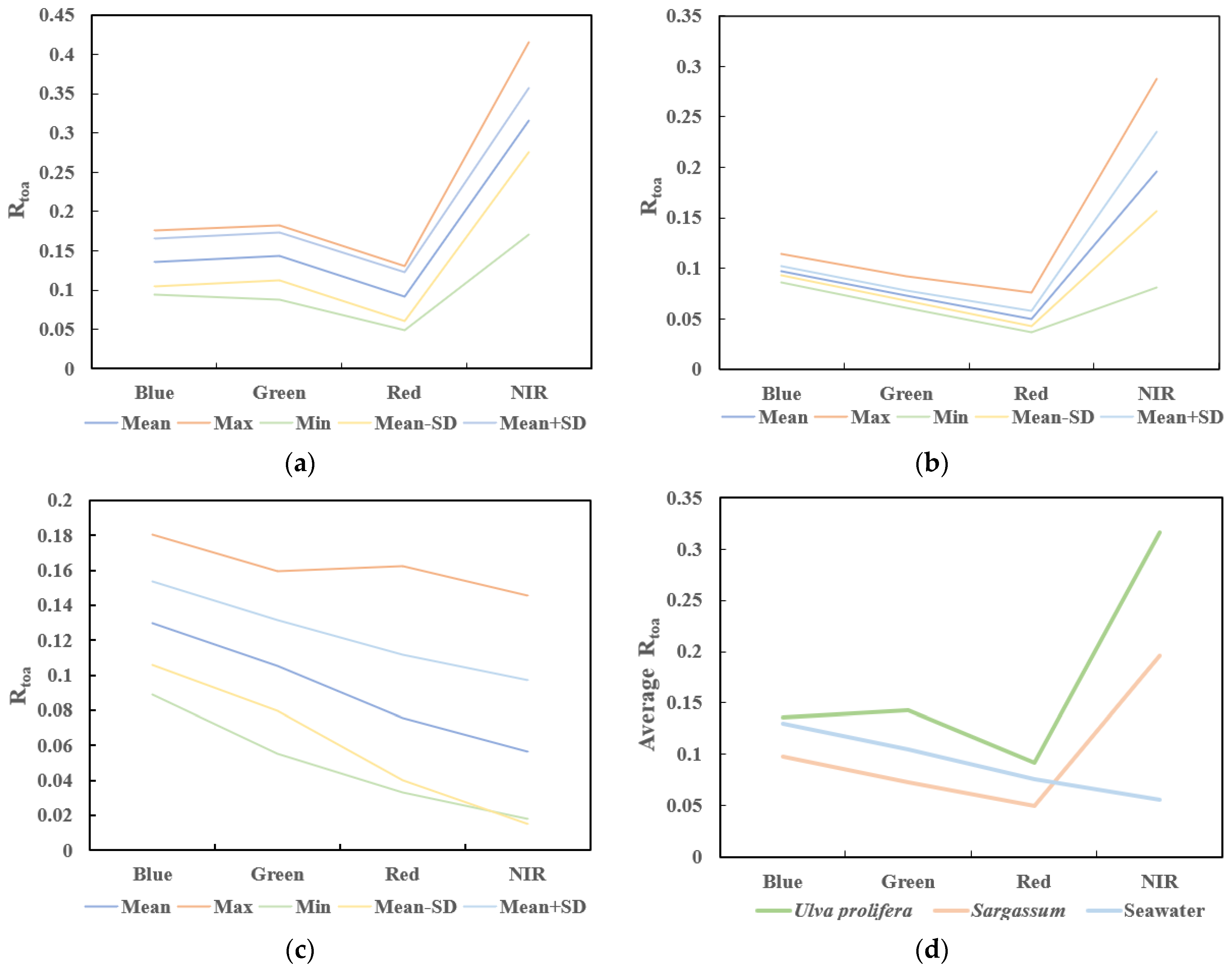
Figure 2 illustrate that the reflectance of Ulva prolifera and Sargassum in the near-infrared band is markedly higher than that of seawater. Ulva prolifera exhibits spectral characteristics of Rtoa,Green > Rtoa,Blue and Rtoa,Green > Rtoa,Red. In certain aquatic settings, the reflectance in the blue band slightly exceeds that in the green band. Sargassum demonstrates spectral attributes of Rtoa,Blue > Rtoa,Green > Rtao,Red. Moreover, quantitative analysis of Rtoa values was performed for Ulva prolifera, Sargassum, and seawater. The Rtoa value of Ulva prolifera is typically higher than that of Ulva prolifera in the green band, with average Rtoa values of 0.136 and 0.097 for Ulva prolifera and Sargassum, respectively. In the red band, the Rtoa value of Ulva prolifera slightly surpasses that of Sargassum.

3.2. Separation of Algae and Seawater

Both Ulva prolifera and Sargassum, which are two types of algae, demonstrate low reflectance in the red band and elevated reflectance in the near-infrared band [26]. In contrast, seawater lacks this attribute. The Difference Vegetation Index (DVI) is an index specifically utilizing the red and near-infrared bands for extracting vegetation information. Unlike NDVI, DVI exhibits effective performance in mitigating the effects of sun glint and thin clouds. Typically, the DVI value is negative for seawater and positive for vegetation. Hence, the initial application of DVI with a predetermined threshold distinguishes between algae and seawater. Subsequently, floating algae in the images are extracted through visual interpretation and the utilization of false-color images. Because of the resemblance in the red and near-infrared band reflectance between Ulva prolifera and Sargassum, their DVI values display some degree of overlap. Thus, the application of DVI for further differentiation between Ulva prolifera and Sargassum presents challenges.
D V I = R t o a , N I R R t o a , r e d
Specifically, Rtoa,red and Rtoa,NIR correspond to the 665 nm and 842 nm bands of the Sentinel-2 MSI dataset.

3.3. Differentiation of Ulva prolifera and Sargassum by the SUI-I Index

Utilizing the spectral distinctions between Ulva prolifera and Sargassum, the SUI-I index is employed for discrimination. The SUI-I index is formulated as the ratio of green band reflectance to the linear baseline between the blue and red bands, expressed by the following equation:
S U I I = R t o a , G r e e n R t o a , R e d + R t o a , B l u e R t o a , R e d λ R e d λ G r e e n / λ R e d λ B l u e / R t o a , G r e e n
Threshold values are chosen based on false-color images and visual interpretation to discern between Ulva prolifera and Sargassum.

3.4. Distinguishing Ulva prolifera and Sargassum Based on the Random Forest Algorithm

For model training purposes, 6606, 8141, and 10,000 pixels were individually sampled from a coexisting image of Ulva prolifera and Sargassum, representing seawater, Ulva prolifera, and Sargassum categories. Three spectral attributes, derived from the distinctive spectra of Ulva prolifera, Sargassum, and seawater, were examined and employed as inputs for the random forest model, as shown in Table 4:
The formulation of the blue–green band index in this study relies on the spectral variances between Ulva prolifera and Sargassum.

4. Algorithm Evaluation and Application

4.1. Accuracy Evaluation

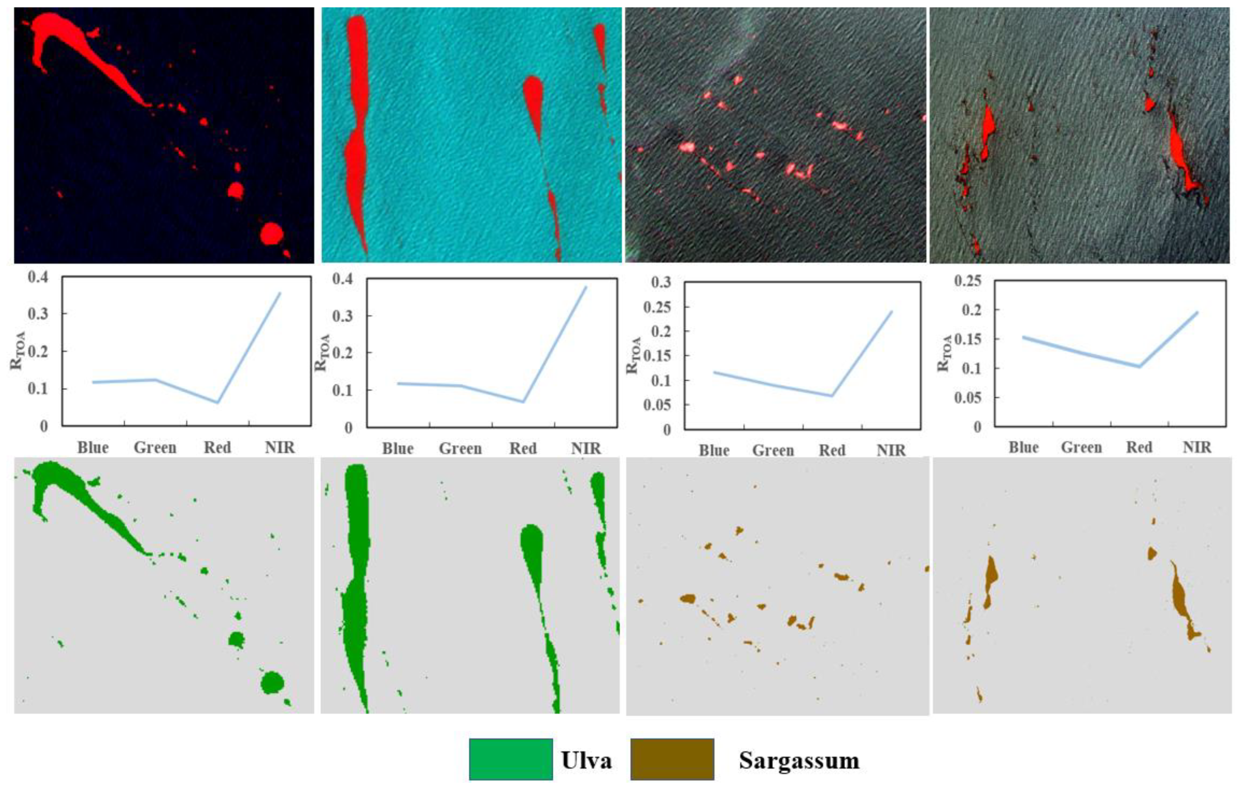
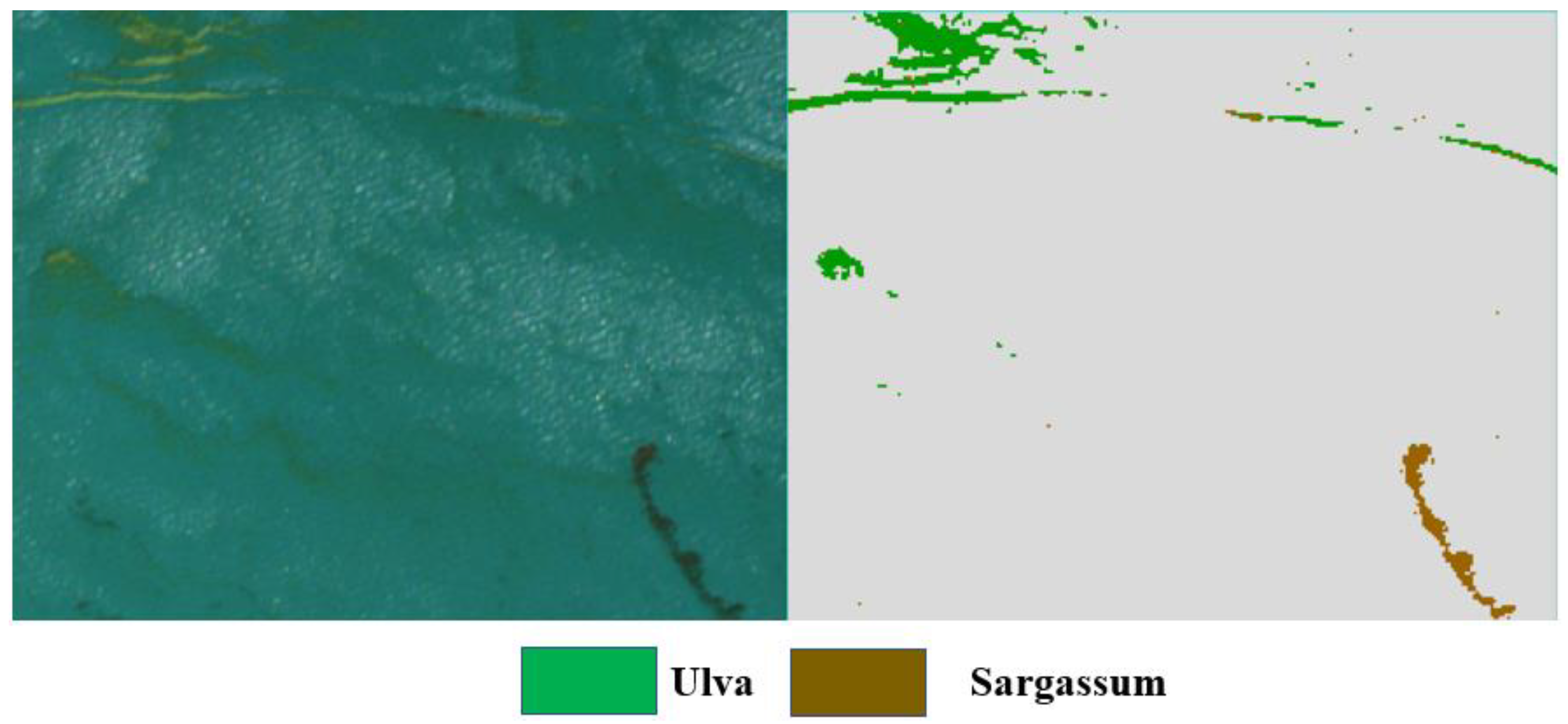
In order to validate the algorithm’s effectiveness, we select a total of four satellite images for the purpose of illustrating the algorithm introduced in this paper. The outcomes of the extraction process are depicted in Figure 3 and Figure 4. Accuracy analysis was conducted based on metrics encompassing overall accuracy, precision, recall, and F1 score. The extraction results of the SUI-I index are presented in Table 5, while the algorithm’s extraction outcomes are delineated in Table 6.
Upon comparing the accuracy values within the tabulated data, it becomes evident that upon applying this algorithm to the test images, the F1 scores for Ulva prolifera and Sargassum were both 99.1%. These outcomes serve to highlight the efficacy of our proposed approach in effectively discriminating between these two types of algae taxons.

4.2. The Algorithm Is Applied to GF-1 WFV Data

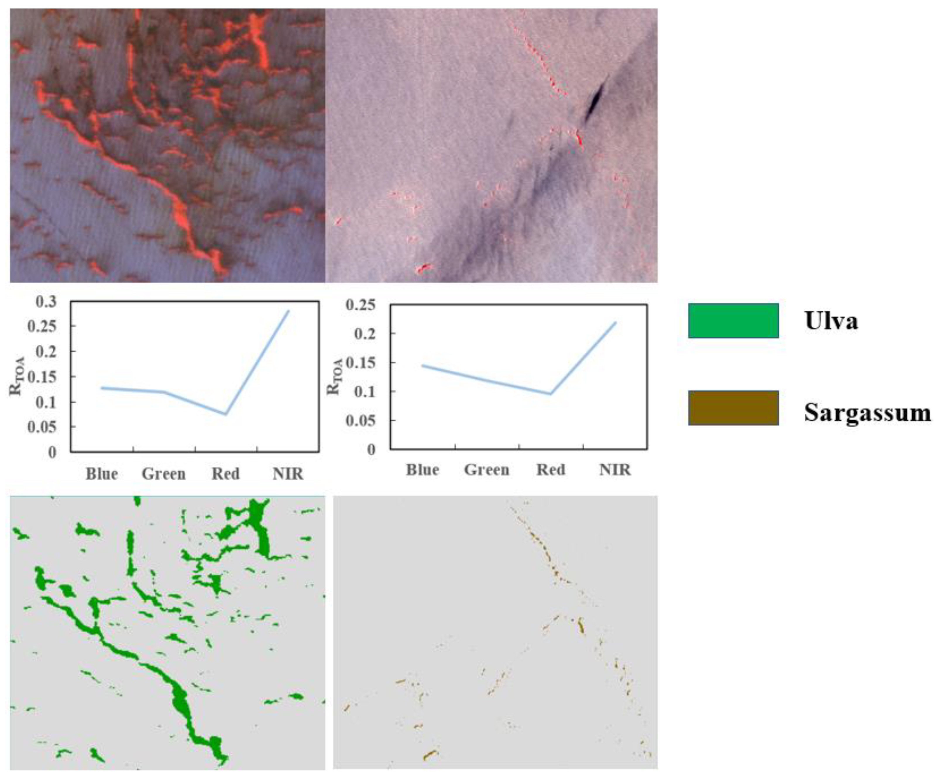
To assess the algorithm’s practicality, we applied it to GF-1 WFV data. Following quantitative assessment, Ulva prolifera and Sargassum achieved F1 scores of 97.9% and 97.1%, respectively, suggesting that the algorithm effectively classifies GF-1 WFV data with a notable degree of generalization capability. The extraction results of GF-1 WFV image are shown in Figure 5.

4.3. Comparative Analysis of the Temporal and Spatial Distribution of East China Sea Algae and Its Vicinity Waters in 2017 and 2023

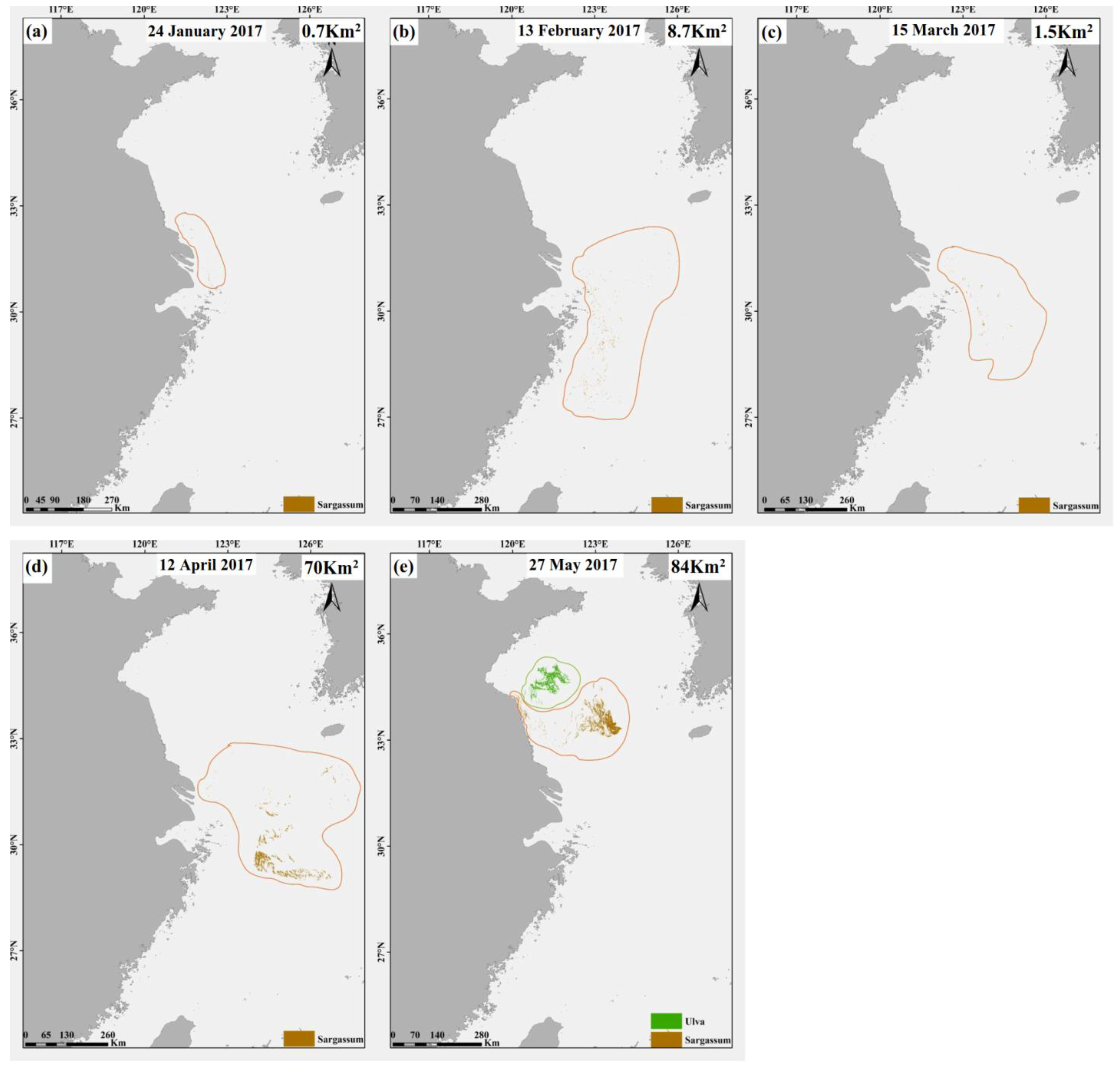
In 2017 and 2023, extensive algal blooms were observed in both the Yellow Sea and the East China Sea. In this research, we employed GF-1 WFV satellite data and our proprietary algorithm to identify algae between January and May in both years. We conducted an analysis of the spatial and temporal distribution of the algae, as illustrated in Figure 6 and Figure 7. We calculated the monthly distribution area of algae by multiplying the detected pixel count of Ulva prolifera by the individual pixel area in GF-1 WFV images (256 m2), as presented in Table 7 and Table 8. Comparative analysis indicated the presence of Ulva prolifera in January 2017, while only a limited amount was noted in February 2023. Furthermore, from January to March, the Ulva prolifera coverage area remained generally small, primarily concentrated within the coordinates of 122° E–125° E, 30° N–32° N. However, in April, the Ulva prolifera coverage area experienced a substantial increase, reaching 70 Km2 in 2017 and 90 Km2 in 2023. This implies that Ulva prolifera exhibits growth during its drift over time, corroborating previous findings regarding its northward drift along the Zhejiang coast during the summer [27]. Notably, in May 2017, there was no decrease in the distribution area of Ulva prolifera. Nevertheless, in May 2023, the Ulva prolifera distribution area started to decrease, concurrent with the emergence of Ulva prolifera near the Northern Jiangsu Shoal. Due to GF-1 WFV not covering the total area of the Yellow Sea and East China Sea in certain months’ images and partial cloud cover in some images, an accurate assessment of the Ulva prolifera distribution area for these months was unattainable. These data serve as valuable references for economically evaluating Ulva prolifera resources and mitigating the adverse effects of harmful algal blooms. It is important to note that the estimated coverage area of Ulva prolifera in this study might be underestimated due to the presence of pixels with an area smaller than 256 m2, which may not be accurately identified.

5. Discussion

This study presents an efficient, accurate, and user-friendly algorithm grounded in the random forest technique. It is designed to distinguish between Ulva prolifera and Sargassum using high spatial resolution satellite data. Initially, a spectral analysis was conducted on Ulva prolifera, Sargassum, and seawater. The results revealed a high reflectance in the near-infrared band for both Ulva prolifera and Sargassum. Leveraging this characteristic, the Difference Vegetation Index (DVI) was employed to discriminate between algae and seawater. Secondly, the primary spectral distinctions between Ulva prolifera and Sargassum emerge in the green band. As a result, the SUI-I index and the blue–green band index were utilized to distinguish between the two algae types. These three spectral characteristics were employed as parameters to train the random forest model. The trained model was then employed to predict additional satellite images from Sentinel-2 and GF-1 WFV. In contrast, our approach concurrently distinguishes seawater, Ulva prolifera, and Sargassum, as opposed to the two-step differentiation of macroalgae and seawater followed by the two types of algae discriminations by Xiao et al. and Sun et al. [15,16]. Additionally, our method utilizes atmospheric apparent reflectance, obviating the requirement for intricate atmospheric correction and the ambiguous threshold selection procedure; it also validates the feasibility of utilizing atmospheric apparent reflectance for the surveillance of macroalgae. To assess the model’s suitability, it was employed on high-precision GF-1 satellite imagery, conducting a comparative analysis of the temporal and spatial distribution of floating macroalgae from January to May in both 2017 and 2023. In terms of time, we found that Sargassum typically begins to appear in February, reaching its maximum area in May, accompanied by a small amount of Ulva prolifera. The two algae species were not perfectly synchronized in time. Spatially, During the drifting process, Sargassum experiences some growth and drifts northward. However, the exact cause of the expansion of the golden tides needs to be investigated. Furthermore, the maximum area covered by Ulva in 2023 did not decrease compared to that in 2017. While the spatial resolution of GF-1 WFV data is very high, the instability of cloud cover in the imagery results in low data availability. Subsequent research will primarily concentrate on the investigation of multi-source satellite remote sensing data. However, in areas characterized by complex water backgrounds and glare, the optical properties of macroalgae may undergo alterations, potentially resulting in the misclassification of certain algal species. Additionally, the suitability of this algorithm for other high-resolution satellites has not been examined. Consequently, future endeavors will encompass algorithm optimization to enhance the precision of Ulva prolifera and Sargassum horneri identification in intricate regions, along with an exploration of the suitability of other high-resolution satellite data. This will better leverage remote sensing technology for the monitoring of large-scale algae disasters in China.

6. Conclusions

The present study employs a random forest model to differentiate between Ulva prolifera and Sargassum within satellite images, with a focus on the Yellow Sea and East China Sea regions as study areas. The findings demonstrate that the random forest algorithm, trained on Sentinel-2 images, adeptly distinguishes Ulva prolifera and Sargassum with high accuracy. In comparison to the SUI-I threshold extraction method, this model showcases superior performance. Concurrently, this algorithm is suitable for processing GF-1 WFV imagery, enabling quantitative analysis of the distribution of sizable floating algae in the years 2017 and 2023. This research introduces a methodology for discriminating between Ulva prolifera and Sargassum. In contrast to lower-resolution datasets, the extensive utilization of high-resolution satellite remote sensing data significantly augments the capacity for precise monitoring of coastal algal blooms. This research establishes the viability of utilizing satellite Rtoa signals for large-scale algae monitoring, thereby providing novel perspectives on the remote sensing monitoring of algal disasters in marine and lacustrine environments. The 2023 extraction results of this study also provide key information for the optimization of disaster control measures. Subsequent research endeavors will concentrate on enhancing the precision of model monitoring, broadening the scope of study areas, and investigating the generalization capacities of the mode.

Author Contributions

Conceptualization, Q.X., D.Y. and J.L. (Jinming Li); methodology, J.L. (Jinming Li) and J.L. (Jinghu Li); software, J.L. (Jinming Li) and J.L. (Jinghu Li); formal analysis, J.L. (Jinming Li), Q.X. and D.Y.; resources, D.Y. and Q.X.; writing—original draft preparation, J.L. (Jinming Li); writing—review and editing, D.Y., Q.X. and D.A.; project administration, D.Y.; funding acquisition, D.Y. and Q.X. All authors have read and agreed to the published version of the manuscript.

Funding

This research received financial support from the National Natural Science Foundation of China (42076188,42106172); Natural Science Foundation of Shandong Province (ZR2021QD135, ZR2022QD061, ZR2023QD018, ZR2023QD023, ZR2023QD066); Natural Science Foundation of Qingdao (23-2-1-72-zyyd-jch, 23-2-1-58-zyyd-jch); Qingdao Marine Science and Technology Innovation Project (23-1-3-hygg-6-hy); Project Plan of Pilot Project of Integration of Science, Education and Industry (2022GH004, 2022PY041, 2023JBZ03); University-Industry Collaborative Education Program (202102245036).

Data Availability Statement

According to the requirements of the confidentiality agreement, the data used in this paper are not public.

Acknowledgments

The authors are thankful to the anonymous reviewers for their useful suggestions.

Conflicts of Interest

The authors declare no conflict of interest.

References

  1. Kong, F.Z.; Jiang, P.; Wei, C.J.; Zhang, Q.C.; Li, J.Y.; Liu, Y.T.; Yu, R.C.; Yan, T.; Zhou, M.J. Co-occurence of green tide,golden tide and red tides along the 35° N transect in the Yellow sea during spring and summer in 2017. J. Oceanol. Limnol. 2018, 49, 1021–1030. [Google Scholar]
  2. Yu, R.C.; Liu, D.Y. Harmful Algal Blooms in the Coastal Waters of China: Current Situation, Long-term Changes and Prevention Strategies. Bull. Chin. Acad. Sci. 2016, 31, 1167–1174. [Google Scholar] [CrossRef]
  3. Xing, Q.G.; Hu, C.M. Mapping macroalgal blooms in the Yellow Sea and East China Sea using HJ-1 and Landsat data: Application of a virtual baseline reflectance height technique. Remote Sens. Environ. 2016, 178, 113–126. [Google Scholar] [CrossRef]
  4. Smetacek, V.; Zingone, A. Green and golden seaweed tides on the rise. Nature 2013, 504, 84–88. [Google Scholar] [CrossRef]
  5. Chen, Y.L.; Wan, J.H.; Zhang, J.; Ma, Y.J.; Wang, L.; Zhao, J.H.; Wang, Z.Z. Spatial-temporal distribution of golden tide based on high-resolution satellite remote sensing in the South Yellow Sea. J. Coastal. Res. 2019, 90, 221–227. [Google Scholar] [CrossRef]
  6. Liu, J.L.; Xia, J.; Zhuang, M.M.; Zhang, J.H.; Sun, Y.Q.; Tong, Y.C.; Zhao, S.; He, P.M. Golden seaweed tides accumulated in Pyropia aquaculture areas are becoming a normal phenomenon in the Yellow Sea of China. Sci. Total Environ. 2021, 774, 145726. [Google Scholar] [CrossRef]
  7. Hu, C.M.; Li, D.Q.; Chen, C.S.; Ge, J.Z.; Muller-Karger, F.E.; Liu, J.P.; Yu, F.; He, M.X. On the recurrent Ulva prolifera blooms in the Yellow Sea and East China Sea. J. Geophys. Res. Oceans. 2010, 115, C5. [Google Scholar] [CrossRef]
  8. Liu, D.Y.; Keesing, J.K.; Xing, Q.G.; Shi, P. World’s largest macroalgal bloom caused by expansion of seaweed aquaculture in China. Mar. Pollut Bull. 2009, 58, 888–895. [Google Scholar] [CrossRef]
  9. Xing, Q.G.; Guo, R.H.; Wu, L.L.; An, D.Y.; Cong, M.; Qin, S.; Li, X.R. High-resolution satellite observations of a new hazard of golden tides caused by floating Sargassum in winter in the Yellow Sea. IEEE. Geosci. Remote Sens. Lett. 2017, 14, 1815–1819. [Google Scholar] [CrossRef]
  10. Wang, M.Q.; Hu, C.M. Mapping and quantifying Sargassum distribution and coverage in the Central West Atlantic using MODIS observations. Remote Sens. Environ. 2016, 183, 350–367. [Google Scholar] [CrossRef]
  11. Xiao, Y.F.; Zhang, J.; Cui, T.W.; Gong, J.L.; Liu, R.J.; Chen, X.Y.; Liang, X.J. Remote sensing estimation of the biomass of floating Ulva prolifera and analysis of the main factors driving the interannual variability of the biomass in the Yellow Sea. Mar. Pollut Bull. 2019, 140, 330–340. [Google Scholar] [CrossRef] [PubMed]
  12. Shi, W.; Wang, M.H. Green macroalgae blooms in the Yellow Sea during the spring and summer of 2008. J. Geophys. Res. Oceans. 2009, 114, C12. [Google Scholar] [CrossRef]
  13. Hu, C.M. A novel ocean color index to detect floating algae in the global oceans. Remote Sens. Environ. 2009, 113, 2118–2129. [Google Scholar] [CrossRef]
  14. Jin, S.; Han, Z.; Liu, Y. A Remote Sening Method for Discriminating Ulva Prolifra and Sargassum. Remote Sening Inform. 2016, 4, 4–48. [Google Scholar]
  15. Sun, D.Y.; Chen, Y.; Wang, S.Q.; Zhang, H.L.; Qiu, Z.F.; Mao, Z.H.; He, Y.J. Using Landsat 8 OLI data to differentiate Sargassum and Ulva prolifera blooms in the South Yellow Sea. Int. J. Appl. Earth Obs. Geoinf. 2021, 98, 102302. [Google Scholar] [CrossRef]
  16. Xiao, Y.F.; Liu, R.J.; Kim, K.Y.; Zhang, J.; Cui, T.W. A random forest-based algorithm to distinguish Ulva prolifera and Sargassum from multispectral satellite images. IEEE Trans. Geosci. Electron. 2021, 60, 1–15. [Google Scholar] [CrossRef]
  17. Liang, X.J.; Qin, P.; Xiao, Y.F.; Kim, K.Y.; Liu, R.J.; Chen, X.Y.; Wang, Q.B. Automatic remote sensing detection of floating macroalgae in the yellow and east china seas using extreme learning machine. J. Coastal Res. 2019, 90, 272–281. [Google Scholar] [CrossRef]
  18. Qi, L.; Hu, C.M.; Wang, M.Q.; Shang, S.L.; Wilson, C. Floating algae blooms in the East China Sea. Geophys. Res. Lett. 2017, 44, 11,501–11,509. [Google Scholar] [CrossRef]
  19. Qi, L.; Hu, C.M.; Xing, Q.G.; Shang, S.L. Long-term trend of Ulva prolifera blooms in the western Yellow Sea. Harmful Algae 2016, 58, 35–44. [Google Scholar] [CrossRef]
  20. Liu, D.Y.; Keesing, J.K.; He, P.M.; Wang, Z.L.; Shi, Y.J.; Wang, Y.J. The world’s largest macroalgal bloom in the Yellow Sea, China: Formation and implications. Estuarine. Coast. Shelf Sci. 2013, 129, 2–10. [Google Scholar] [CrossRef]
  21. Hu, C.M.; Barnes, B.B.; Murch, B.; Carlson, P.R. Satellite-based virtual buoy system to monitor coastal water quality. Opt. Eng. 2014, 53, 051402. [Google Scholar] [CrossRef]
  22. Revel, C.; Lonjou, V.; Marcq, S.; Desjardins, C.; Fougnie, B.; Coppolani-Delle Luche, C.; Guilleminot, N.; Lacamp, A.; Lourme, E.; Miquel, C. Sentinel-2A and 2B absolute calibration monitoring. Eur. J. Remote Sens. 2019, 52, 122–137. [Google Scholar] [CrossRef]
  23. Fletcher, K. SENTINEL 2: ESA’s Optical High-Resolution Mission for GMES Operational Services. Remote Sens. Environ. 2012, 120, 25–36. [Google Scholar] [CrossRef]
  24. Breiman, L. Random forests. Mach. Learn. 2001, 45, 5–32. [Google Scholar] [CrossRef]
  25. Belgiu, M.; Drăguţ, L. Random forest in remote sensing: A review of applications and future directions. ISPRS J. Photogramm. Remote Sens. 2016, 114, 24–31. [Google Scholar] [CrossRef]
  26. Zhang, J.H.; Ding, X.W.; Zhuang, M.M.; Wang, S.Y.; Chen, L.; Shen, H.; He, P.M. An increase in new Sargassum (Phaeophyceae) blooms along the coast of the East China Sea and Yellow Sea. Phycologia 2019, 58, 374–381. [Google Scholar] [CrossRef]
  27. Hu, C.M.; Feng, L.; Hardy, R.F.; Hochberg, E.J. Spectral and spatial requirements of remote measurements of pelagic Sargassum macroalgae. Remote Sens. Environ. 2015, 167, 229–246. [Google Scholar] [CrossRef]
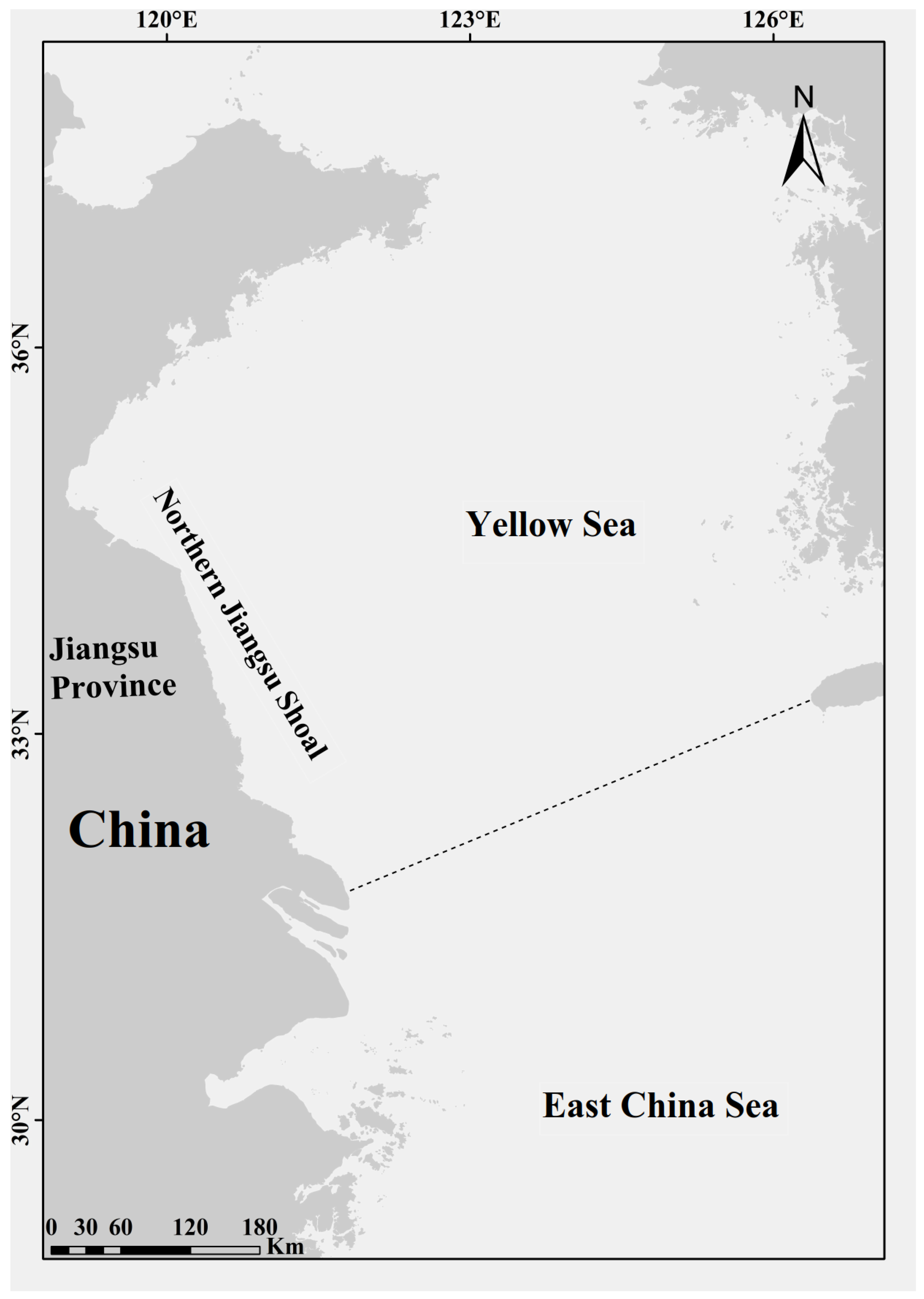
Figure 1. Study area of the East China Sea and its vicinity.
Water 15 03797 g001
Figure 2. (a) Spectral information statistical analysis of Ulva prolifera. (b) Spectral statistical analysis of Sargassum. (c) Spectral statistical analysis of seawater. (d) Average spectral curves of Ulva prolifera, Sargassum, and seawater.
Water 15 03797 g002
Figure 3. The results of distinguishing Ulva prolifera and Sargassum using the random forest algorithm. The top image is a false-color composite image of Sentinel-2 MSI (composed of Band 8–Near Infrared; Band 4–Red; and Band 3–Green), and the middle line graph shows the remote sensing reflectance (RTOA) spectra of floating algae. The bottom image shows the classification results of Ulva and Sargassum based on the random forest algorithm.
Water 15 03797 g003
Figure 4. Differentiation results of symbiotic images.
Water 15 03797 g004
Figure 5. The top image is a false-color composite image of GF-1 WFV (composed of Band 4–Near Infrared; Band 3–Red; and Band 2–Green), and the middle line graph shows the remote sensing reflectance (RTOA) spectra of floating algae. The bottom image shows the classification results of Ulva and Sargassum based on the random forest algorithm.
Water 15 03797 g005
Figure 6. The distribution of floating macroalgae from 24 January to 27 May 2017, sourced from GF-1 WFV satellite images (ae).
Water 15 03797 g006
Figure 7. The distribution of floating macroalgae from 27 February to 13 May 2023 was derived from GF-1 WFV satellite images (ae).
Water 15 03797 g007
Table 1. Satellite imagery used in this article.
DateData
23 May 2017S2A_MSIL1C_20170523T021611_N0205_R003_T51SXT_20170523T022351data
26 May 2017S2A_MSIL1C_20170526T022551_N0205_R046_T51SWR_20170526T023526
3 June 2019S2B_MSIL1C_20190603T023559_N0207_R089_T51SUU_20190603T061117
18 June 2019S2A_MSIL1C_20190618T023551_N0207_R089_T51STU_20190618T042557
28 May 2020S2B_MSIL1C_20200528T023549_N0209_R089_T51SUU_20200528T054012
Table 2. Visible and near-infrared band satellite sensor information.
Sentinel-2 MSIGF-1 WFV
Central WavelengthBand1:490 nmBand1:484 nm
Band2:560 nmBand2:560 nm
Band3:665 nmBand3:665 nm
Band4:842 nmBand4:800 nm
Spital resolution10 m16 m
Swath290 km200 km
Revisit time5 days4 days
Table 3. Confusion matrix.
Positive Example-Predicted ValueCounterexample-Predicted Value
Positive example-Actual valueTPFN
Negative example-Actual valueFPTN
Table 4. The three spectral features created as input variables for the random forest model.
AbbreviationDescriptionFormula
Blue-GreenDifferences between the blue light spectrum and the green light spectrum. R t o a , G r e e n R t o a , B l u e / ( R t o a , G r e e n + R t o a , B l u e )
DVIDifference Vegetation Index R t o a , N I R R t o a , r e d
SUI-IUlva prolifera and Sargassum Index R t o a , G r e e n R t o a , R e d + R t o a , B l u e R t o a , R e d λ R e d λ G r e e n / λ R e d λ B l u e / R t o a , G r e e n
Table 5. SUI-I index extraction results.
SUI-I-UlvaSUI-I-Sargassum
Ulva-labeled10872257
Sargassum-labeled3049814
Precision97.3%97.4%
Recall97.7%97.0%
F197.5%97.2%
Table 6. Random forest algorithm extraction results in this article.
RF-UlvaRF-UlvaSUI-I-Sargassum
Ulva-labeled1,424,6941216
Sargassum-labeled11310,96353
Precision901810,010
Recall 99.7%99.3%
F1 98.5%98.9%
Table 7. The area of Sargassum from January to May 2017.
Date24 January 201713 February 201715 March 2017 *12 April 201727 May 2017
Area
Km2
0.78.71.57084
Notes: * There is a lack of satellite imagery here. GF−1 WFV images on this day did not cover the total area of the Yellow and East China Seas.
Table 8. The area of Sargassum in February to May 2023.
Date20 February 202321 March 2023 *10 April 202327 April 202313 May 2023
Area
Km2
0.16.090.555.420.4
Notes: * There is a lack of satellite imagery here. GF−1 WFV images on this day did not cover the total area of the Yellow and East China Seas.
Disclaimer/Publisher’s Note: The statements, opinions and data contained in all publications are solely those of the individual author(s) and contributor(s) and not of MDPI and/or the editor(s). MDPI and/or the editor(s) disclaim responsibility for any injury to people or property resulting from any ideas, methods, instructions or products referred to in the content.