
Assessment of Spatial Distribution and Temporal Variations of the Phreatic Groundwater Level Using Geostatistical Modelling: The Case of Oued Souf Valley—Southern East of Algeria


Abstract
1. Introduction
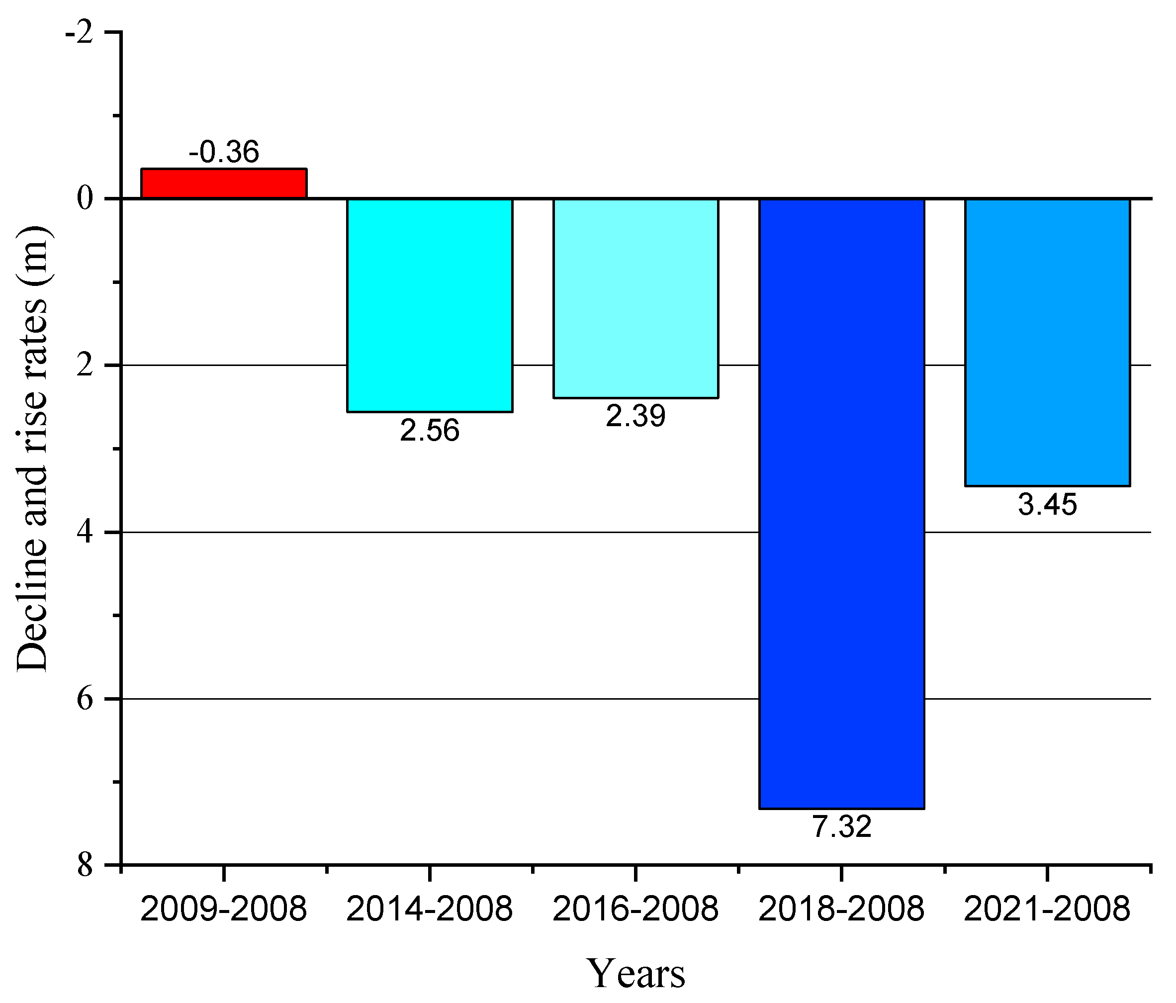
- How is the vertical drainage system performing and what is its impact on fighting upwelling of the phreatic groundwater table and its stability between 2008, 2009, 2014, 2016, 2018, and 2021 in terms of spatial distribution and temporal variation of the phreatic groundwater fluctuation?
- How can the weakness of water resources management in El Oued contribute to the continuity of the upwelling of groundwater?
2. Materials and Methods
2.1. Study Area Description
2.2. Climatology of the Study Area
2.3. Geomorphology, Geology and Hydrogeology
2.4. Vertical Drainage System
2.5. Data Collection
2.6. Geostatistical Modelling
2.7. Clustering Analysis
3. Results and Discussion
3.1. Hierarchical Clustering of Groundwater Levels
3.2. Geostatistical Modelling and Groundwater Level Fluctuations
4. Conclusions
Author Contributions
Funding
Institutional Review Board Statement
Informed Consent Statement
Data Availability Statement
Acknowledgments
Conflicts of Interest
References
- Táany, R.A.; Tahboub, A.B.; Saffarini, G.A. Geostatistical Analysis of Spatiotemporal Variability of Groundwater Level Fluctuations in Amman-Zarqa Basin, Jordan: A Case Study. Environ. Geol. 2009, 57, 525–535. [Google Scholar] [CrossRef]
- UNWWDR. The United Nations World Water Development Report; UNESCO Publishing: Paris, France, 2015. [Google Scholar]
- Nayak, P.C.; Satyaji Rao, Y.R.; Sudheer, K.P. Groundwater Level Forecasting in a Shallow Aquifer Using Artificial Neural Network Approach. Water Resour. Manag. 2006, 20, 77–90. [Google Scholar] [CrossRef]
- Tatawat, R.K.; Chandel, C.P.S. A Hydrochemical Profile for Assessing the Groundwater Quality of Jaipur City. Environ. Monit. Assess. 2008, 143, 337–343. [Google Scholar] [CrossRef] [PubMed]
- Kumar, V.; Remadevi. Kriging of Groundwater Levels-A Case Study. J. Spat. Hydrol. 2006, 6, 81–92. [Google Scholar]
- Ravikumar, P.; Somashekar, R.K.; Angami, M. Hydrochemistry and Evaluation of Groundwater Suitability for Irrigation and Drinking Purposes in the Markandeya River Basin, Belgaum District, Karnataka State, India. Environ. Monit. Assess. 2011, 173, 459–487. [Google Scholar] [CrossRef]
- Luna, M.C.D.M.; Parteli, E.J.R.; Herrmann, H.J. Model for a Dune Field with an Exposed Water Table. Geomorphology 2012, 159–160, 169–177. [Google Scholar] [CrossRef]
- Jha, M.K.; Chowdhury, A.; Chowdary, V.M.; Peiffer, S. Groundwater Management and Development by Integrated Remote Sensing and Geographic Information Systems: Prospects and Constraints. Water Resour. Manag. 2007, 21, 427–467. [Google Scholar] [CrossRef]
- Drouiche, N.; Ghaffour, N.; Naceur, M.W.; Mahmoudi, H.; Ouslimane, T. Reasons for the Fast Growing Seawater Desalination Capacity in Algeria. Water Resour. Manag. 2011, 25, 2743–2754. [Google Scholar] [CrossRef]
- Harrat, N.; Achour, S. Pollution Physico-Chimique Des Eaux de Barrage de La Région d’El Tarf. Impact Sur La Chloration. Larhyss J. 2010, 8, 47–54. [Google Scholar]
- Sekkoum, K.; Talhi, M.F.; Cheriti, A.; Bourmita, Y.; Belboukhari, N.; Boulenouar, N.; Taleb, S. Water in Algerian Sahara: Environmental and Health Impact. Adv. Desalin. 2012, 197–216. [Google Scholar] [CrossRef]
- (Ministère des Ressources en eau) Ministry of Water Resources. Available online: https://www.mre.gov.dz/?page_id=1991 (accessed on 1 January 2020).
- Abdous, B.; Besbes, M.; Fezzani, C.; Latrech, D.; Mamou, A. Systeme Aquifere du Sahara Septentrional: Gestion Commune d’un Bassin Transfrontière; La Houille Blanche: Ouargla, Algeria, 2005; Volume 12. [Google Scholar]
- ANRH. Ressources En Eau et En Sols de l’Algérie; Rapport Technique; ANRH: Alger, Algeria, 1986. [Google Scholar]
- Daoudi, A.; Lejars, C.; Benouniche, N. La Gouvernance de l’Eau Souterraine Dans Le Sahara Algérien: Enjeux, Cadre Légal et Pratiques Locales. Cah. Agric. 2017, 26, 35004. [Google Scholar] [CrossRef]
- Negm, A.; Omran, E.; Bouderbala, A.; Chenchouni, H.; Barcelo, D. Introduction to “Water Resources in Algeria: Assessment of Surface and Groundwater Resources”. In Water Resources in Algeria-Part I.; Springer: Cham, Germany, 2020; ISBN 978-3-030-57894-7. [Google Scholar]
- Drouiche, N.; Ghaffour, N.; Naceur, M.W.; Lounici, H.; Drouiche, M. Towards Sustainable Water Management in Algeria. Desalin. Water Treat. 2012, 50, 272–284. [Google Scholar] [CrossRef]
- Côte, M. Si Le Souf m’était Conté: Comment Se Fait et Se Défait Un Paysage; Hannachi, S., Ed.; Média-Plus: Constantine, Algeria, 2006; ISBN 9961-922-42-5. [Google Scholar]
- Bataillon, C. Le Souf, Étude de Géographie Humaine; Université d’Alger: Algiers, Algeria, 1955. [Google Scholar]
- Kadri, S.R.; Chaouche, S. La Remontée Des Eaux Dans La Région Du Souf: Une Menace Sur Un Écosystème Oasien. Les Cah. D’emam 2018, 30. [Google Scholar] [CrossRef]
- Côte, M. Dynamique Urbaine Au Sahara. Rev. Algérienne D’anthropologie Sci. Soc. 1998, 5, 85–92. [Google Scholar] [CrossRef]
- Bouzegag, C.; Bouzid-Lagha, S.; Djelal, N. Forecasting the Upwelling Phenomenon Using an Artificial Neural Network. Pol. J. Soil Sci. 2020, 53, 245–259. [Google Scholar] [CrossRef]
- Khezzani, B.; Bouchemal, S. Variations in Groundwater Levels and Quality Due to Agricultural Over-Exploitation in an Arid Environment: The Phreatic Aquifer of the Souf Oasis (Algerian Sahara). Environ. Earth Sci. 2018, 77, 1–18. [Google Scholar] [CrossRef]
- Messekher, I.; Chabour, N.; Menani, R. Remontée de La Nappe Phréatique Du Souf. Conséquences et Solutions Envisagées. Ann. Univ. Buchar. Geogr. Ser. 2012, LXI, 179–197. [Google Scholar]
- Khechana, S.; Miloudi, A.; Ghomri, A.; Guedda, E.H.; Derradji, E.F. Failure of a Vertical Drainage System Installed to Fight the Rise of Groundwater in El-Oued Valley (SE Algeria): Causes and Proposed Solutions. J. Fail. Anal. Prev. 2016, 16, 216–224. [Google Scholar] [CrossRef]
- Medareg Narou, B.H.; Farhi, A. Le Rôle Des Services et Des Investissements Dans l’hypertrophie de La Ville d’El Oued Au Bas Sahara Algérien. Environ. Urbain 2009, 3, c-1–c-18. [Google Scholar] [CrossRef][Green Version]
- Remini, B. La disparition des ghouts dans la region d’el oued (Algérie). Larhyss J. 2006, 5, 49–62. [Google Scholar]
- Remini, B.; Kechad, R. Impact of the Water Table Razing on the Degradation of El Oued Palm Plantation (Algeria) Mechanisms and Solutions. Geogr. Tech. 2011, 13, 48–56. [Google Scholar]
- Rouhani, S.; Wackernagel, H. Multivariate Geostatistical Approach to Space-Time Data Analysis. Water Resour. Res. 1990, 26, 585–591. [Google Scholar] [CrossRef]
- Kenda, K.; Peternelj, J.; Mellios, N.; Kofinas, D.; Čerin, M.; Rožanec, J. Usage of Statistical Modeling Techniques in Surface and Groundwater Level Prediction. J. Water Supply Res. Technol. AQUA 2020, 69, 248–265. [Google Scholar] [CrossRef]
- Goovaerts, P. Geostatistics for Natural Resources Evaluation; Oxford University Press on Demand: Oxford, UK, 1997. [Google Scholar]
- Isaaks, E.; Srivastava, R.M. An Introduction to Applied Geostatistics; Oxford University Press: New York, NY, USA, 1989. [Google Scholar]
- Journel, A.; Huijbregts, C. Mining Geostatistics; Academic Press: London, UK, 1978. [Google Scholar]
- Seyedmohammadi, J.; Esmaeelnejad, L.; Shabanpour, M. Spatial Variation Modelling of Groundwater Electrical Conductivity Using Geostatistics and GIS. Model. Earth Syst. Environ. 2016, 2, 1–10. [Google Scholar] [CrossRef]
- Venkatramanan, S.; Chung, S.Y.; Kim, T.H.; Kim, B.W.; Selvam, S. Geostatistical Techniques to Evaluate Groundwater Contamination and Its Sources in Miryang City, Korea. Environ. Earth Sci. 2016, 75, 1–14. [Google Scholar] [CrossRef]
- Barkat, A.; Bouaicha, F.; Bouteraa, O.; Ata, B.; Balla, D.; Rahal, Z.; Szabó, G. Assessment of Complex Terminal Groundwater Aquifer for Different Use of Oued Souf Valley (Algeria) Using Multivariate Statistical Methods, Geostatistical Modeling, and Water Quality Index. Water 2021, 11, 1609. [Google Scholar] [CrossRef]
- Knotters, M.; Bierkens, M.F.P. Predicting Water Table Depths in Space and Time Using a Regionalised Time Series Model. Geoderma 2001, 103, 51–77. [Google Scholar] [CrossRef]
- Desbarats, A.J.; Logan, C.E.; Hinton, M.J.; Sharpe, D.R. On the Kriging of Water Table Elevations Using Collateral Information from a Digital Elevation Model. J. Hydrol. 2002, 255, 25–38. [Google Scholar] [CrossRef]
- Theodossiou, N.; Latinopoulos, P. Evaluation and Optimisation of Groundwater Observation Networks Using the Kriging Methodology. Environ. Model. Softw. 2006, 21, 991–1000. [Google Scholar] [CrossRef]
- Gundogdu, K.S.; Guney, I. Spatial Analyses of Groundwater Levels Using Universal Kriging. J. Earth Syst. Sci. 2007, 116, 49–55. [Google Scholar] [CrossRef]
- Uyan, M.; Cay, T. Spatial Analyses of Groundwater Level Differences Using Geostatistical Modeling. Environ. Ecol. Stat. 2013, 20, 633–646. [Google Scholar] [CrossRef]
- Xiao, Y.; Gu, X.; Yin, S.; Shao, J.; Cui, Y.; Zhang, Q.; Niu, Y. Geostatistical Interpolation Model Selection Based on ArcGIS and Spatio-Temporal Variability Analysis of Groundwater Level in Piedmont Plains, Northwest China. Springerplus 2016, 5, 1–15. [Google Scholar] [CrossRef] [PubMed]
- Güler, C.; Thyne, G.D.; McCray, J.E.; Turner, A.K. Evaluation of Graphical and Multivariate Statistical Methods for Classification of Water Chemistry Data. Hydrogeol. J. 2002, 10, 455–474. [Google Scholar] [CrossRef]
- Belkhiri, L.; Boudoukha, A.; Mouni, L.; Baouz, T. Multivariate Statistical Characterization of Groundwater Quality in Ain Azel Plain, Algeria. Afr. J. Environ. Sci. Technol. 2010, 4, 526–534. [Google Scholar] [CrossRef]
- Yang, Q.; Zhang, J.; Wang, Y.; Fang, Y.; Martín, J.D. Multivariate Statistical Analysis of Hydrochemical Data for Shallow Ground Water Quality Factor Identification in a Coastal Aquifer. Pol. J. Environ. Stud. 2016, 24, 769–776. [Google Scholar] [CrossRef]
- Massart, D.; Kaufman, L. The Interpretation of Analytical Chemical Data by the Use of Cluster Analysis; Wiley: New York, NY, USA, 1983. [Google Scholar]
- Khezzani, B.; Bouchemal, S. Demographic and Spatio-Temporal Distribution of Cutaneous Leishmaniasis in the Souf Oasis (Eastern South of Algeria): Results of 13 Years. Acta Trop. 2017, 166, 74–80. [Google Scholar] [CrossRef]
- Abdaoui, G.R.; Amine, T.A.; Foued, B.; Ahmed, B. Bouchemal Salah Sprawl, Specificity and Dynamics of Inter-Municipal Urban Agglomerations of Sprawl, Specificity and Dynamics of Inter-Municipal Urban Agglomerations of the Souf Valley (South East Algeria): Using GIS Techniques. Int. J. Innov. Appl. Stud. 2020, 4, 991–1014. [Google Scholar]
- Miloudi, A.M.; Remini, B. The Ghout of Souf: An Original Hydroagricultural System. Geosci. Eng. 2019, 64, 30–37. [Google Scholar] [CrossRef]
- Djennane, A. Constat de Situation Dans Des Zones Sud Des Oasis Algériennes. Les Systèmes Agric. Oasiens 1990, 11, 29–40. [Google Scholar]
- Dubief, J. Le Climat Du Sahara. Ann. Georgr. 1965, 74, 360–361. [Google Scholar] [CrossRef]
- Debaeke, P.; Puech, J.; Casals, M.L.; Petibon, P. Élaboration Du Rendement Du Blé d’hiver En Conditions de Déficit Hydrique. I. Étude En Lysimètres. Agronomie 1996, 16, 3–23. [Google Scholar] [CrossRef]
- Bouchet, R.; Hallaire, M. La Réserve Hydrique Du Sol Facilement Utilisable, Ses Variations et Sa Signification. In Proceedings of the Comm. Colloque Franco-Polonais de L’aménagemen t et de L’économi e de l’eau, Varsovie, Poland; 1964; p. 15. Available online: https://hal.archives-ouvertes.fr/hal-01595478/document (accessed on 23 March 2022).
- Bel, F.; Demargne, F.F. Etude Géologique Du Continental Terminal; Rapport Technique; ANRH: Algiers, Algeria, 1966. [Google Scholar]
- Bel, F.; Cuche, D. Etude Des Nappes Du Complexe Terminal Du Bas Sahara; Données Géologiques et Hydrogéologiques Pour La Construction Du Modèle Mathématique; DHW: Ouargla, Algeria, 1970. [Google Scholar]
- Sebaa, A.; Berroussi, S.; Bouhanna, M.; Benazzouz, M. Utilisation des Methodes Traditionnelles de Lutte Contre L’ensablement Dans le Bas—Sahara Algerien: Le Tas De Remblai. J. Algérien Des. Régions Arid. 2009, 21, 96–107. [Google Scholar]
- Ballais, J.; Côte, M.; Bensaad, A. L’influence de La Géomorphologie Sur Le Comportement de La Nappe Phréatique Du Souf. Ph.D. Thesis, Université de Provence, Marseille, France, 2002. [Google Scholar]
- Fabre, J. Introduction à La Géologie Du Sahara Algérien et Des. Régions Voisines; Société Nationale d’Édition et de Diffusion: Algiers, Algeria, 1976; ISBN 84-499-2264-X. [Google Scholar]
- Nesson, C. L’évolution Des Ressources Hydrauliques Dans Les Oasis Du Bas-Sahara Algérien. GéoProdig Portail D’information Géographique 1975, 17, 7–99. [Google Scholar]
- Busson, G. Principes, Méthodes et Résultats d’une Étude Stratigraphique Du MésozoÏque Saharien; Éditions du Muséum: Paris, France, 1972; Volume 26. [Google Scholar]
- Giraud, R. Le Continental Terminal En Algérie; Ann. Fac. Sci.: Dakkar, Senegal, 1978; Volume 31. [Google Scholar]
- Chebbah, M.; Allia, Z. Geochemistry and Hydrogeochemical Process of Groundwater in the Souf Valley of Low Septentrional Sahara, Algeria. Afr. J. Environ. Sci. Technol. 2015, 9, 261–273. [Google Scholar] [CrossRef]
- Drouiche, A.; Chaab, S.; Khechana, S. Impact Du Deversement Direct Des Eaux Usees et de Drainage Dans La Nappe Libre de l’Oued Souf et Son Influence Sur La Qualite Des Eaux Souterraines. Synthèse Rev. Sci. Technol. 2013, 62, 50–62. [Google Scholar]
- Kerényi, A.; McIntosh, R. Sustainable Development in Changing Complex Earth Systems; Springer: Berlin/Heidelberg, Germany, 2020; ISBN 9783030216443. [Google Scholar]
- Khechana, S.; Derradji, F.; Mega, N. Caractéristiques Hydrochimiques Des Eaux de La Nappe Phréatique Du Vallée d’Oued-Souf (SE Algérien). Eur. J. Sci. Res. 2011, 62, 207–215. [Google Scholar]
- Messekher, I.; Menani, M. Evolution de La Piezometrie de La Ville d’Oued Souf (Entre 1993, 2002 et 2007): Perspectives de La Maitrise Du Phenomene de Remont e de La Nappe Phréatique. J. Int. Net. Environ. Manag. Conf. 2010, 1, 259–266. [Google Scholar]
- Meziani, A.; Dridi, H. The Aquifer System of the Souf Valley: Algerian Northern Sahara. Eur. J. Sci. Res. 2011, 65, 416–423. [Google Scholar]
- Guendouz, A.; Michelot, J.L. Chlorine-36 Dating of Deep Groundwater from Northern Sahara. J. Hydrol. 2006, 328, 572–580. [Google Scholar] [CrossRef]
- Castany, G. Sedimentary Basin of the Northern Sahara (Algeria, Tunisia). Intercalary Continental and Terminal Complex Aquifers [Confined Groundwater, Multilevel System, Hydrodynamics, Management of Water Resources, and Environment. Bull. Du Bur. Rech. Geol. Min. Sect. 3 Hydrogeol. Geol. L’ingenieur 1982, 2, 127–147. [Google Scholar]
- Najah, A. Le Souf Des. Oasis; Editions La Maison des Livres: Alger, France, 1970. [Google Scholar]
- Dervierux, F. La Nappe Phréatique Du Souf (Région d’El Oued, Algérie)-Etude Du Renouvellement de La Nappe. Terres Eaux OCRS 3trim 1957, 56, 12–39. [Google Scholar]
- Ben Hamida, S. Iventaire Des Forages d’eau de La Wilaya d’El Oued; Agence National des Ressources Hydraulique (ANRH): Ouargla, Algérie, 2005. [Google Scholar]
- DRE Inventaire Des Puits Traditionnels de La Wilaya d’El-Oued; Direction des Ressources en Eau de Wilaya (DRE): El Oued, Algeria, 2015.
- Kherici, N.; Zounini, D.; Kherici, H. Origine de La Remontee Des Eaux Dans La Nappe Superficielle de Souf (Nord-Est Du Sahara Septentrional Algerien). Hidrogeología 1996, 12, 49–59. [Google Scholar]
- Guendouz, A.; Moulla, A.S.; Edmunds, W.M.; Zouari, K.; Shand, P.; Mamou, A. Hydrogeochemical and Isotopic Evolution of Water in the Complexe Terminal Aquifer in the Algerian Sahara. Hydrogeol. J. 2003, 11, 483–495. [Google Scholar] [CrossRef]
- Gonçalvès, J.; Petersen, J.; Deschamps, P.; Hamelin, B.; Baba-Sy, O. Quantifying the Modern Recharge of the “Fossil” Sahara Aquifers. Geophys. Res. Lett. 2013, 40, 2673–2678. [Google Scholar] [CrossRef]
- Cornet, A. Introduction à l’hydrogéologie Saharienne. Géorg. Phys. Géol. Dyn 1946, 6, 5–72. [Google Scholar]
- UNESCO. Etude Des Ressources En Eau de Sahara Septentrional; UNESCO: Paris, France, 1972; Volume 7. [Google Scholar]
- Burri, J.; Burri, J. Vallée Du Souf: Etudes d’assainissement Des Eaux Résiduaires, Pluviales et d’irrigation. In Mesures Complémentaires de Lutte Contre La Remontée de La Nappe Phréatique; Bonard et Gardel (BG): Lausanne, Switzerland, 2004. [Google Scholar]
- Chen, L.; Feng, Q. Geostatistical Analysis of Temporal and Spatial Variations in Groundwater Levels and Quality in the Minqin Oasis, Northwest China. Environ. Earth Sci. 2013, 70, 1367–1378. [Google Scholar] [CrossRef]
- Montero, J.; Fernández-Avilés, G.; Mateu, J. Spatial and Spatio-Temporal Geostatistical Modeling and Kriging; John Wiley & Sons: Hoboken, NJ, USA, 2015. [Google Scholar]
- Webster, R.; Oliver, M. Geostatistics for Environmental Scientists; John Wiley & Sons: Hoboken, NJ, USA, 2007. [Google Scholar]
- Kumar, A.; Maroju, S.; Bhat, A. Application of ArcGIS Geostatistical Analyst for Interpolating Environmental Data from Observations. Environ. Prog. 2007, 26, 220–225. [Google Scholar] [CrossRef]
- Ahmadi, S.H.; Sedghamiz, A. Geostatistical Analysis of Spatial and Temporal Variations of Groundwater Level. Environ. Monit. Assess. 2007, 129, 277–294. [Google Scholar] [CrossRef]
- Mei, K.; Liao, L.; Zhu, Y.; Lu, P.; Wang, Z.; Dahlgren, R.A.; Zhang, M. Evaluation of Spatial-Temporal Variations and Trends in Surface Water Quality across a Rural-Suburban-Urban Interface. Environ. Sci. Pollut. Res. 2014, 21, 8036–8051. [Google Scholar] [CrossRef]
- Seo, Y.; Kim, S.; Singh, V.P. Estimating Spatial Precipitation Using Regression Kriging and Artificial Neural Network Residual Kriging (RKNNRK) Hybrid Approach. Water Resour. Manag. 2015, 29, 2189–2204. [Google Scholar] [CrossRef]
- Cressie, N.; Hawkins, D. Robust Estimation of the Variogram: I. J. Int. Assoc. Math. Geol. 1980, 12, 115–125. [Google Scholar] [CrossRef]
- Oliver, M.A.; Webster, R. A Tutorial Guide to Geostatistics: Computing and Modelling Variograms and Kriging. Catena 2014, 113, 56–69. [Google Scholar] [CrossRef]
- Delhomme, J.P. Kriging in the Hydrosciences. Adv. Water Resour. 1978, 1, 251–266. [Google Scholar] [CrossRef]
- Pebesma, E.J. Multivariable Geostatistics in S: The Gstat Package. Comput. Geosci. 2004, 30, 683–691. [Google Scholar] [CrossRef]
- Adhikary, P.P.; Chandrasekharan, H.; Chakraborty, D.; Kamble, K. Assessment of Groundwater Pollution in West Delhi, India Using Geostatistical Approach. Environ. Monit. Assess. 2010, 167, 599–615. [Google Scholar] [CrossRef] [PubMed]
- Bhuiyan, M.A.H.; Suruvi, N.I.; Dampare, S.B.; Islam, M.A.; Quraishi, S.B.; Ganyaglo, S.; Suzuki, S. Investigation of the Possible Sources of Heavy Metal Contamination in Lagoon and Canal Water in the Tannery Industrial Area in Dhaka, Bangladesh. Environ. Monit. Assess. 2011, 175, 633–649. [Google Scholar] [CrossRef] [PubMed]
- Bouaicha, F.; Dib, H.; Belkhiri, L.; Manchar, N.; Chabour, N. Hydrogeochemistry and Geothermometry of Thermal Springs from the Guelma Region, Algeria. J. Geol. Soc. India 2017, 90, 226–232. [Google Scholar] [CrossRef]
- Bouteraa, O.; Mebarki, A.; Bouaicha, F.; Nouaceur, Z.; Laignel, B. Groundwater Quality Assessment Using Multivariate Analysis, Geostatistical Modeling, and Water Quality Index (WQI): A Case of Study in the Boumerzoug-El Khroub Valley of Northeast Algeria. Acta Geochim. 2019, 38, 796–814. [Google Scholar] [CrossRef]
- Emenike, P.G.C.; Nnaji, C.C.; Tenebe, I.T. Assessment of Geospatial and Hydrochemical Interactions of Groundwater Quality, Southwestern Nigeria. Environ. Monit. Assess. 2018, 190, 440. [Google Scholar] [CrossRef]
- Cambardella, C.A.; Moorman, T.B.; Novak, J.M.; Parkin, T.B.; Karlen, D.L.; Turco, R.F.; Konopka, A.E. Field-Scale Variability of Soil Properties in Central Iowa Soils. Soil Sci. Soc. Am. J. 1994, 58, 1501–1511. [Google Scholar] [CrossRef]


| Months | Jan | Feb | Mar | Apr | May | Jun | Jul | Aug | Sep | Oct | Nov | Dec | Total |
|---|---|---|---|---|---|---|---|---|---|---|---|---|---|
| P (mm) | 13.89 | 5.06 | 7.84 | 7.38 | 4.47 | 1.44 | 0.23 | 1.81 | 5.62 | 6.56 | 7.41 | 5.92 | 67.63 |
| PET (mm) | 62.16 | 81.14 | 133.59 | 177.32 | 222.80 | 246.43 | 260.13 | 234.27 | 175.67 | 124.95 | 75.44 | 56.75 | 1850.66 |
| EUR (mm) | 0 | 0 | 0 | 0 | 0 | 0 | 0 | 0 | 0 | 0 | 0 | 0 | 0 |
| RET (mm) | 13.89 | 5.06 | 7.84 | 7.38 | 4.47 | 1.44 | 0.23 | 1.81 | 5.62 | 6.56 | 7.41 | 5.92 | 67.63 |
| AD (mm) | 48.28 | 76.08 | 125.75 | 169.94 | 218.33 | 244.99 | 259.90 | 232.46 | 170.05 | 118.38 | 68.03 | 50.83 | 1783.03 |
| R (mm) | 0 | 0 | 0 | 0 | 0 | 0 | 0 | 0 | 0 | 0 | 0 | 0 | 0 |
| I (mm) | 0 | 0 | 0 | 0 | 0 | 0 | 0 | 0 | 0 | 0 | 0 | 0 | 0 |
| Groups | Years | 2008 | 2009 | 2014 | 2016 | 2018 | 2021 | Mean |
|---|---|---|---|---|---|---|---|---|
| Group 1 | N total | 22 | 22 | 22 | 22 | 22 | 22 | 5.91 |
| Min | −0.3 | −0.4 | 0.6 | 1 | 5.1 | 2.1 | ||
| Mean | 2.99 | 2.64 | 5.6 | 6.43 | 11.44 | 6.37 | ||
| Max | 5.92 | 5.46 | 10.36 | 14.48 | 15.8 | 9.5 | ||
| Standard deviation | 1.69 | 1.53 | 2.45 | 3.77 | 3.01 | 2.48 | ||
| Group 2 | N total | 18 | 18 | 18 | 18 | 18 | 18 | 7.74 |
| Min | 2.22 | 2.16 | 4.9 | 1.11 | 10.44 | 8.4 | ||
| Mean | 4.62 | 4.34 | 7.18 | 4.95 | 14.31 | 11.07 | ||
| Max | 7.13 | 7.04 | 12.61 | 7.63 | 28.8 | 15 | ||
| Standard deviation | 1.43 | 1.30 | 1.74 | 1.94 | 4.51 | 1.74 | ||
| Group 3 | N total | 18 | 18 | 18 | 18 | 18 | 18 | 9.31 |
| Min | 4.49 | 4.05 | 7.31 | 7.22 | 7.8 | 6.2 | ||
| Mean | 7.19 | 6.90 | 9.91 | 10.62 | 10.96 | 10.31 | ||
| Max | 11.3 | 10.51 | 14.02 | 15.1 | 14.4 | 15 | ||
| Standard deviation | 1.84 | 1.71 | 2.12 | 2.74 | 2.38 | 2.48 | ||
| Group 4 | N total | 18 | 18 | 18 | 18 | 18 | 18 | 12.98 |
| Min | 8.5 | 7.86 | 11.2 | 11.7 | 14.46 | 6.3 | ||
| Mean | 12.31 | 11.64 | 14.42 | 15.09 | 15.61 | 8.8 | ||
| Max | 15.3 | 15.17 | 18.23 | 19.53 | 19.8 | 12.5 | ||
| Standard deviation | 2.15 | 2.26 | 2.56 | 2.38 | 1.87 | 2.37 |
| Years | N tot | S.D | Mean | C.V(%) | Min | 1st Quartile | Median | 3rd Quartile | Max | Skewness | Kurtosis |
|---|---|---|---|---|---|---|---|---|---|---|---|
| 2008 | 58 | 3.41 | 5.41 | 63.068 | −0.3 | 3.42 | 4.56 | 6.56 | 15.3 | 1.0298 | 0.92 |
| 2009 | 58 | 3.28 | 5.06 | 64.974 | −0.4 | 2.75 | 4.15 | 6.53 | 15.17 | 1.0732 | 1.07 |
| 2014 | 58 | 3.57 | 7.97 | 44.851 | 0.6 | 5.57 | 7.38 | 9.5 | 18.23 | 0.7105 | 0.80 |
| 2016 | 58 | 4.42 | 7.80 | 56.706 | 1 | 4.94 | 7.13 | 9.73 | 19.53 | 0.5096 | −0.33 |
| 2018 | 58 | 3.71 | 12.74 | 29.186 | 5.1 | 10.5 | 12.51 | 14.7 | 28.8 | 1.36985 | 5.309 |
| 2021 | 58 | 3.02 | 8.86 | 34.158 | 2.1 | 7.2 | 9.22 | 11 | 15 | −0.34105 | −0.054 |
| Year | Model | Nugget (C0) | Partial Sill (C) | Sill (C0 + C) | Range (m) | (C0/C0 + C) ×100 | Spatial Dependence |
|---|---|---|---|---|---|---|---|
| 2008 | Pentaspherical | 2.0998 | 13.9606 | 16.0604 | 3054.9 | 13.0744 | Strong |
| 2009 | Hole effect | 3.6392 | 9.2387 | 12.8779 | 3000.3 | 28.2593 | Moderate |
| 2014 | Gaussian | 4.2948 | 13.192 | 17.4868 | 1931 | 24.5602 | Strong |
| 2016 | Circular | 5.8296 | 18.5756 | 24.4052 | 1865.2 | 23.8867 | Strong |
| 2018 | Spherical | 1.4269 | 13.0067 | 14.4336 | 702.55 | 9.8860 | Strong |
| 2021 | STABLE | 3.63 | 6.4 | 10.03 | 5061.97 | 36.1914 | Moderate |
| Years | Prediction Errors | ||||
|---|---|---|---|---|---|
| Mean | Root Mean Square | Average Standard Error | Mean Standardized | Root Mean Square Standardized | |
| 2008 | −0.0334 | 2.5589 | 2.5203 | −0.0095 | 1.0346 |
| 2009 | −0.0307 | 2.4534 | 2.2109 | −0.0102 | 1.1262 |
| 2014 | 0.0024 | 2.6845 | 2.5878 | 0.0028 | 1.0643 |
| 2016 | 0.0415 | 3.1852 | 3.5793 | 0.0044 | 0.9129 |
| 2018 | 0.0157 | 3.4635 | 3.7726 | 0.0083 | 0.948 |
| 2021 | −0.008 | 2.9868 | 2.9775 | −0.0040 | 1.0024 |
Publisher’s Note: MDPI stays neutral with regard to jurisdictional claims in published maps and institutional affiliations. |
© 2022 by the authors. Licensee MDPI, Basel, Switzerland. This article is an open access article distributed under the terms and conditions of the Creative Commons Attribution (CC BY) license (https://creativecommons.org/licenses/by/4.0/).
Share and Cite
Barkat, A.; Bouaicha, F.; Mester, T.; Debabeche, M.; Szabó, G. Assessment of Spatial Distribution and Temporal Variations of the Phreatic Groundwater Level Using Geostatistical Modelling: The Case of Oued Souf Valley—Southern East of Algeria. Water 2022, 14, 1415. https://doi.org/10.3390/w14091415
Barkat A, Bouaicha F, Mester T, Debabeche M, Szabó G. Assessment of Spatial Distribution and Temporal Variations of the Phreatic Groundwater Level Using Geostatistical Modelling: The Case of Oued Souf Valley—Southern East of Algeria. Water. 2022; 14(9):1415. https://doi.org/10.3390/w14091415
Chicago/Turabian StyleBarkat, Ayoub, Foued Bouaicha, Tamás Mester, Mahmoud Debabeche, and György Szabó. 2022. "Assessment of Spatial Distribution and Temporal Variations of the Phreatic Groundwater Level Using Geostatistical Modelling: The Case of Oued Souf Valley—Southern East of Algeria" Water 14, no. 9: 1415. https://doi.org/10.3390/w14091415
APA StyleBarkat, A., Bouaicha, F., Mester, T., Debabeche, M., & Szabó, G. (2022). Assessment of Spatial Distribution and Temporal Variations of the Phreatic Groundwater Level Using Geostatistical Modelling: The Case of Oued Souf Valley—Southern East of Algeria. Water, 14(9), 1415. https://doi.org/10.3390/w14091415