Review

Caral, South America’s Oldest City (2600–1600 BC): ENSO Environmental Changes Influencing the Late Archaic Period Site on the North Central Coast of Peru

by
Charles R. Ortloff
1,2
1
CFD Consultants International, Ltd., 18310 Southview Avenue, Los Gatos, CA 95033, USA
2
Research Associate in Anthropology, Anthropology Department, University of Chicago, 5801 Ellis Avenue, Chicago, IL 60637, USA
Water 2022, 14(9), 1403; https://doi.org/10.3390/w14091403
Submission received: 3 March 2022 / Revised: 21 April 2022 / Accepted: 22 April 2022 / Published: 27 April 2022
(This article belongs to the Special Issue Water Engineering in Ancient Societies)

Abstract

:
The Late Archaic Period (2600–1600 BC) site of Caral, located ~20 km inland from the Pacific Ocean coastline in the Supe Valley of the north central coast of Peru, is subject to CFD analysis to determine the effects of ENSO (El Niño Southern Oscillation) events (mainly, El Niño flooding and drought events) on its agricultural and marine resource base that threatened societal continuity. The first step is to examine relics of major flood events that produced coastal beach ridges composed of deposited flood slurries—the C14 dating of material within beach ridges determines the approximate dates of major flood events. Of interest is the interaction of flood slurry with oceanic currents that produce a linear beach ridge as these events are controlled by fluid mechanics principles. CFD analysis provides the basis for beach ridge geometric linear shape. Concurrent with beach ridge formation from major flood events are landscape changes that affect the agricultural field system and marine resource food supply base of Caral and its satellite sites- here a large beach ridge can block river drainage, raise the groundwater level and, together with aeolian sand transfer from exposed beach flats, convert previously productive agricultural lands into swamps and marshes. One major flood event in ~1600 BC rendered coastal agricultural zones ineffective due to landscape erosion/deposition events together with altering the marine resource base from flood deposition over shellfish gathering and sardine and anchovy netting areas, the net result being that prior agricultural areas shifted to limited-size, inner valley bottomland areas. Agriculture, then supplied by highland sierra amuna reservoir water, led to a high water table supplemented by Supe River water to support agriculture. Later ENSO floods conveyed thin saturated bottomland soils and slurries to coastal areas to further reduce the agricultural base of Supe Valley sites. With the reduction in the inner valley agricultural area from continued flood events, agriculture, on a limited basis, shifted to the plateau area upon which urban Caral and the satellite sites were located. The narrative that follows then provides the basis for the abandonment of Caral and its satellite Supe Valley sites due to the vulnerability of the limited food-supply base subject to major ENSO events.

1. Introduction

The presence of ENSO (El Niño Southern Oscillation) climate variations in the form of long-term drought, flooding, aeolian sand transfer, and sediment deposition/erosion transfer events, and their effect upon the agricultural and marine resource-base sustainability of Peruvian coastal societies, is of importance to understand the influences that affected Andean historical development. While the timing and intensity of El Niño flood landscape deposition and erosion events is manifest from the geophysical analysis of the observed deposition sand and flood slurry layers and erosion/deposition profiles, the soil transfer and deposition geophysics causing landscape changes affecting the agricultural and marine resource zones as a result of such events remain elusive. To understand the geophysics underlying such events, Computational Fluid Dynamics (CFD) analysis is of use using a landscape model of a portion of the Peruvian coastline subject to an El Niño flood. This event produces runoff consisting of a highly viscous slurry mixture containing silt, gravel, rocks and soil particles that proceeds to further erode the rain-saturated landscape to settle and deposit slurry mixed with the captured landscape soil sediments to form a deposition layer on the pre-existing landscape. In the present study, CFD analysis is performed on a model of the Santa-Viru Peruvian north central coastline; the fluid mechanics CFD analysis then duplicates the acts performed by nature to alter the landscape by erosion and deposition flood events. The CFD investigation results substantiate that slurry deposition deposits create coastal linear beach ridges as a result of the flood transported slurry interaction with ocean currents. While linear beach ridge structures are noted in the literature [1,2,3,4,5,6,7], the underlying geophysics of their linear structural formation is a problem in fluid dynamics amenable to solution by use of the CFD methodology- this methodology is used in the subsequent sections to present the evolution of coastal and interior valley landscape changes resulting from the ENSO events. Once the fluid dynamics connection between the El Niño flood events and beach ridge formation is established by CFD analysis, then, together with the fluid mechanics origin and dating of major beach ridge formations on the Peruvian coastline, their effects on the agricultural landscape and marine resource base provides information on the sustainability and continuity of the food-supply base of a society as related to the ENSO flood events. As the change in the landscape brought about by the ENSO flood events alters the agricultural field system base of a society, as well as causing damage to the marine resource base through the disturbance of offshore fisheries and shellfish gathering beds, societal continuity and sustainability can be adversely affected. Such ENSO events are subsequently shown to influence and affect the sustainability of Peruvian north central coast (Norte Chico) societies in the Preceramic, Late Archaic Period (2600–1800 BC) as further analysis reveals. Again, the main purpose of the CFD analysis is to show the fluid mechanics physics behind the landscape alteration that caused ancient coastal societies to ultimately collapse as their agricultural lands and food resource base were compromised by climate-related events.
While field system modifications and defensive technologies against flood events play a vital role in societal sustainability, in a worst case condition, flood damage can be irreversible, and the abandonment of pre-existing agricultural field systems occurs, leading to societal dispersal and termination. Changes derived from the ENSO flood and drought events affecting both the agricultural landscape and the ocean littoral affecting the marine resource base of a society are then key elements to understand and interpret societal structural change events. The chapters that follow provide examples of the use of the CFD methods to provide information as to the modification of the agricultural and marine resource base of the Late Archaic society based at Caral, centered in the Supe Valley of Peru, due to multiple major ENSO events—such events present a case for the ultimate collapse and abandonment of Supe Valley and other Norte Chico sites in the ~1800 BC time frame.

2. Evolution of Late Archaic Sites in the Peruvian Supe Valley

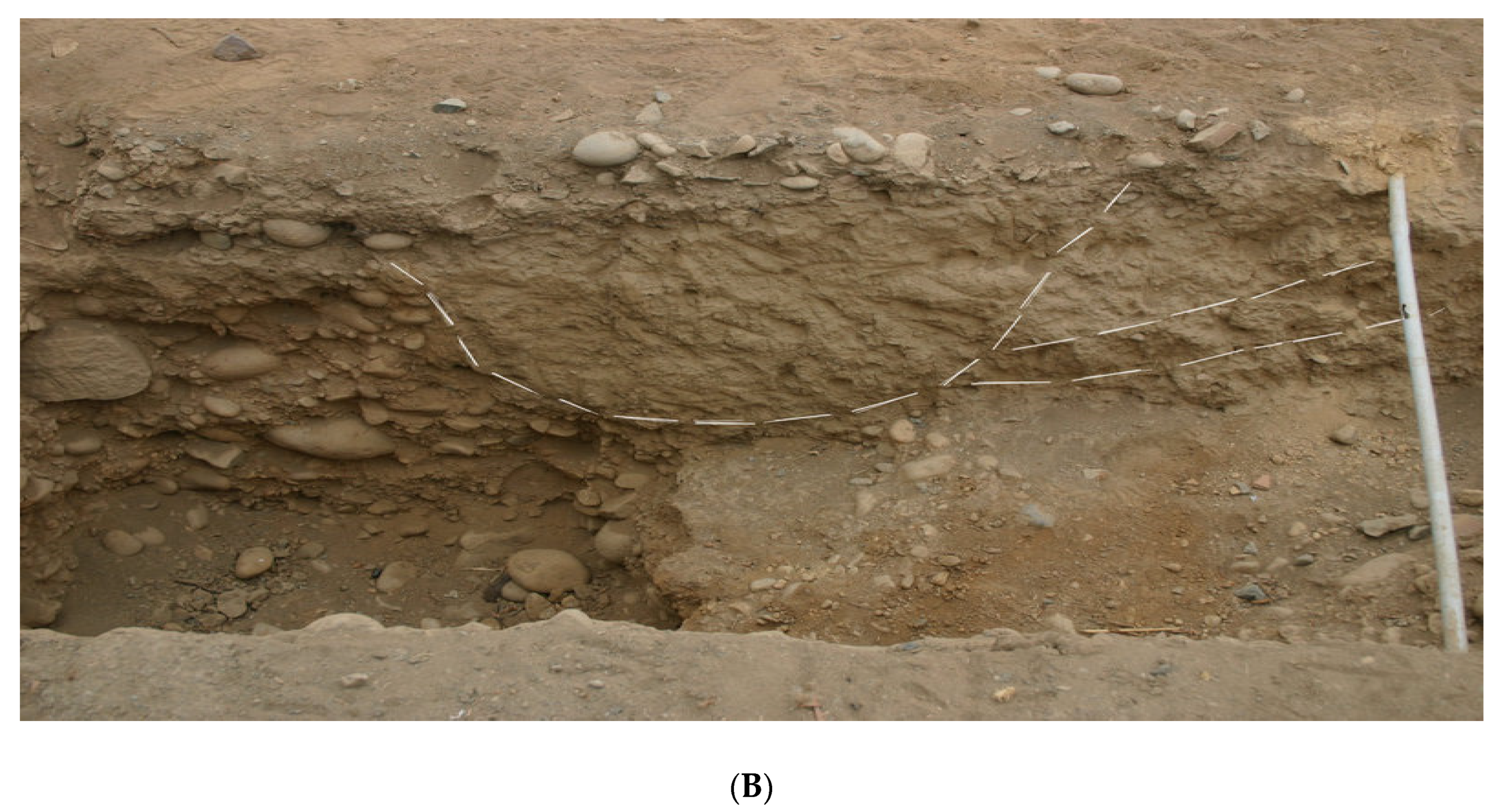
The Late Archaic Period north central coast sites in Peru witnessed increased El Niño ENSO flood events that transferred flood sediments from coastal valleys into ocean currents forming a series of extensive beach ridges. The coastal beach ridges containing C14 datable material are therefore key to date major flood events. Typical interior valley landscape sediment layers and beach ridges resulting from datable multiple deposition/erosion events confirm the timing of major ENSO events, as well as intermediate stable climate periods that permit societal continuity and development between destructive ENSO events. As a result of the formation of multiple barrier beach ridges formed from a sequence of the ENSO flood events, the geophysical history of coastal littoral zones reveals that the river drainage to ocean currents was impeded, resulting in bay infilling and the development of coastal marshes behind the beach ridges. This, together with aeolian sand deposits that infilled agricultural land behind and in front of the beach ridges, compromised the productivity of food supply from agricultural lands. In ancient times (and continuing to present times), aeolian sand-dune incursion into the Supe Valley from constant northwesterly winds from exposed beach flats in valleys south of the Supe Valley compromised Supe Valley agricultural lands. Evidence of this transfer process in Late Archaic times is evident from datable sand layers containing organic material noted in excavation test pits. Thus, beach ridge formations and interior valley sand and flood slurry debris deposition layers from a series of the ENSO events datable to the end of the Late Archaic Period in the Supe Valley provide the basis for agricultural land shrinkage and the changes in the marine resource base that played a major role in the collapse of coastal and valley societies in the Late Archaic Period, as revealed in the subsequent chapters.
Many sites within the Supe Valley, with its ceremonial center at Caral, were based upon the trade of marine resources from coastal sites exchanged with agricultural products from valley interior sites [8,9,10,11,12,13,14,15,16]. 
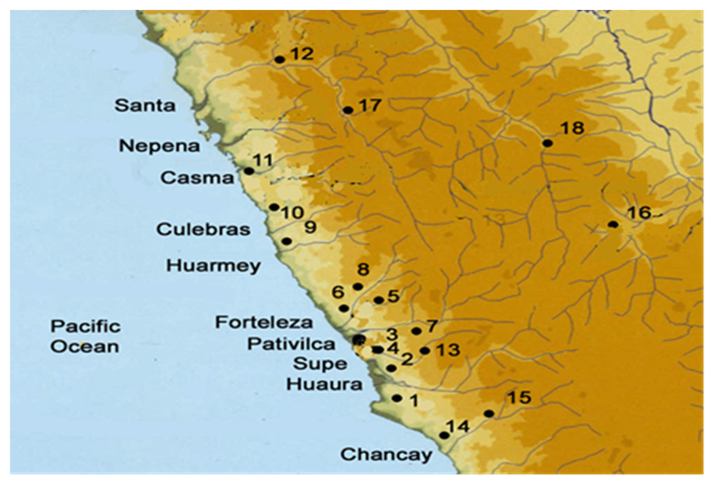
Figure 1 details the location of the major Archaic Period sites; 
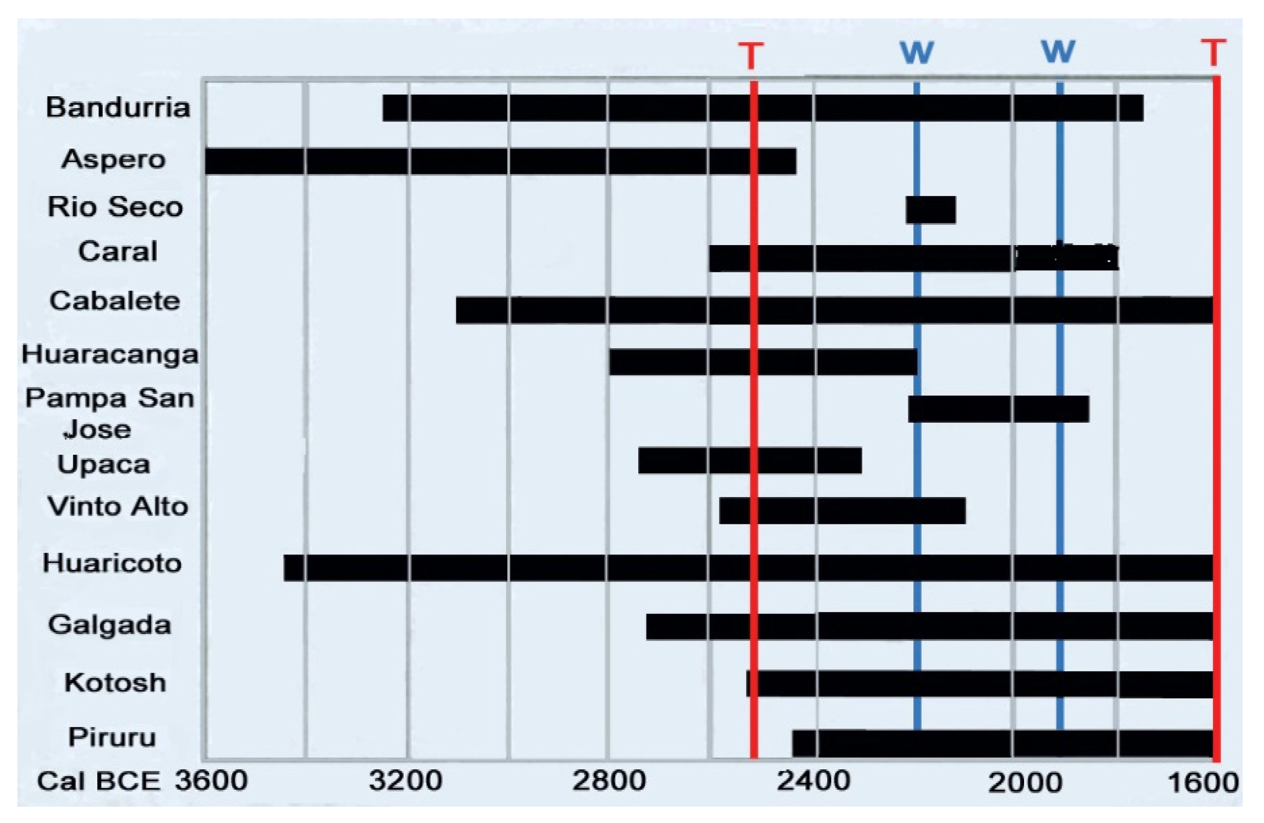
Figure 2 details the existence time of major Supe Valley sites while 
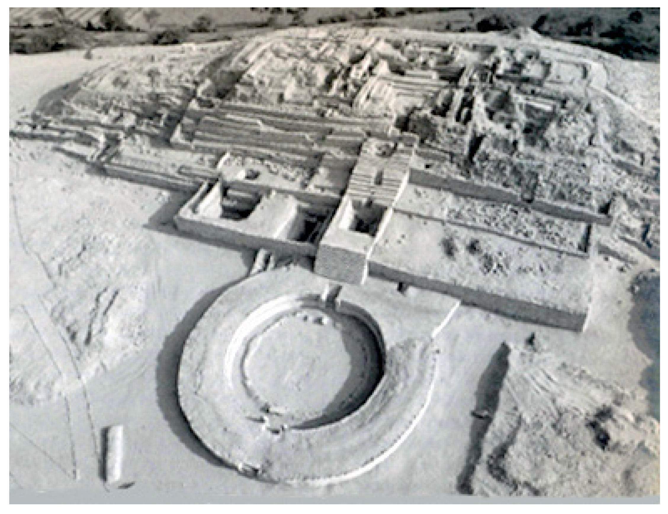
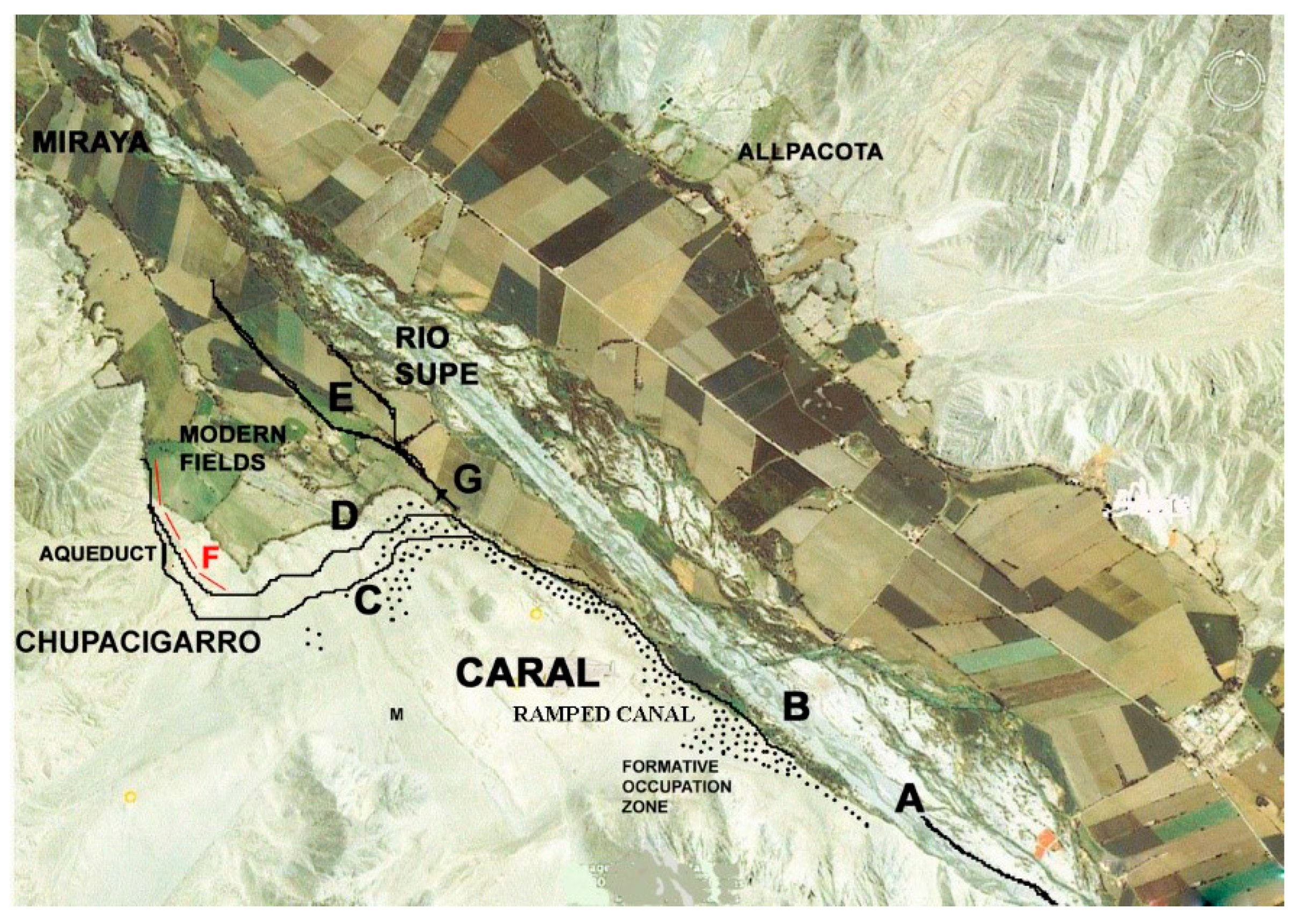
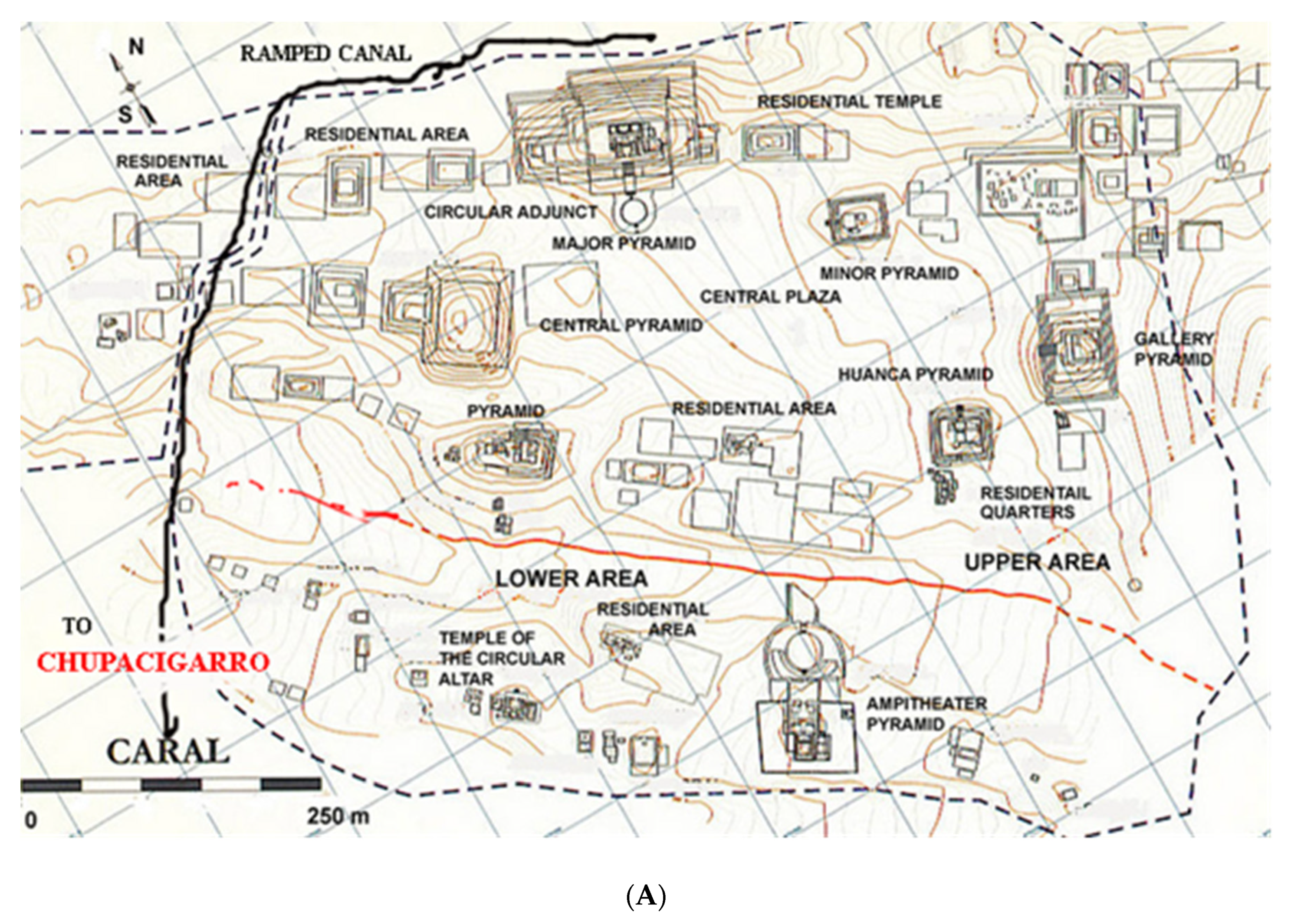
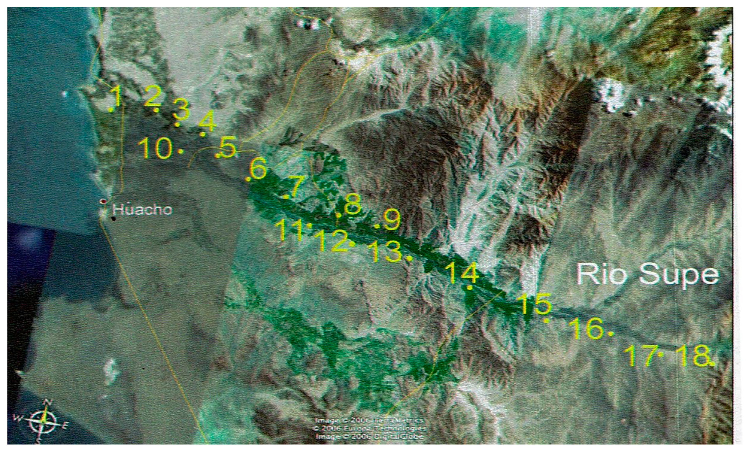
Figure 3 provides the architectural details the Caral site. A probable, but no longer existing, inner city canal is implied from an excavated canal cross-section profile the existence of this early canal is subject of further research as Caral excavations proceed. ENSO landscape disturbances with no possibility of return to previous norms for the agricultural and marine resource of the Supe Valley society of 18 sites (Figure 4) pose a probable reason for the valley site’s abandonment after ~1600 BC and indicate that the dynamic landscape change, as a result of the ENSO events, played a role in the collapse of Late Archaic Period sites in the Norte Chico region of Peru.
The Norte Chico region of Peru is characterized by many Preceramic sites (Figure 1) with different existence dates (Figure 2). Within the Supe Valley are many neighboring individual sites to central Caral (Figure 3 and Figure 4), characterized by complex social organization and urban centers with monumental architecture dominated by truncated, stone-faced pyramid structures of which Huaca Major is typical (Figure 5). The T–T and W–W date band notations (Figure 2) refer to a climate anomaly period [17] influencing worldwide oceanic current shifts with probable influence on the frequency and intensity of El Niño events. As these changes occurred towards the end of the Late Archaic Period, some effect on the study areas may be inferred, but further research is needed to track their specificity to Pacific coastal areas.
The earliest Preceramic societies from the northcentral coast of Peru developed a cooperative economic model based on agricultural trade, irrigation agriculture, and the exploitation of marine resources to sustain large populations in the Late Archaic Period [8]. The nearby sites associated with Caral in the Supe Valley formed a collective integrated societal complex (Figure 4) participating in this exchange network. Coastal sites exploiting marine resources (fish, shellfish and edible seaweed types) traded with inland sites for agricultural and industrial crops, particularly cotton for fishing nets and lines, as well as gourds for net floats. In the Supe Valley alone, 18 sites (Figure 4) evidenced the success of this economic exchange system [8,9,10,11,12,13,14,15,16] over long time periods (Figure 2), which experienced, and successfully survived, changes in environmental conditions brought about by Holocene sea level stabilization, Peru Current establishment and the increased frequency of El Niño flood events [17,18,19]. Again, major flood events were the basis for sedimentary beach ridge deposits inducing river drainage blockage, the creation of coastal marshlands behind drainage barriers, valley water-table height elevation and changes and aggraded sand sea formation behind and in front of beach ridges subject to aeolian sand transport and deposition, all of which influenced the agricultural and marine resource base of valley and coastal sites. Despite these challenges to the food resource base, societal continuity prevailed through relocations of agricultural field systems from coastal to inner valley areas over long time periods; only when ENSO events reached a level of severity without options to continue the food supply base that was sufficient to supply an increasing population did the coastal societies experience a challenge to their continuance.
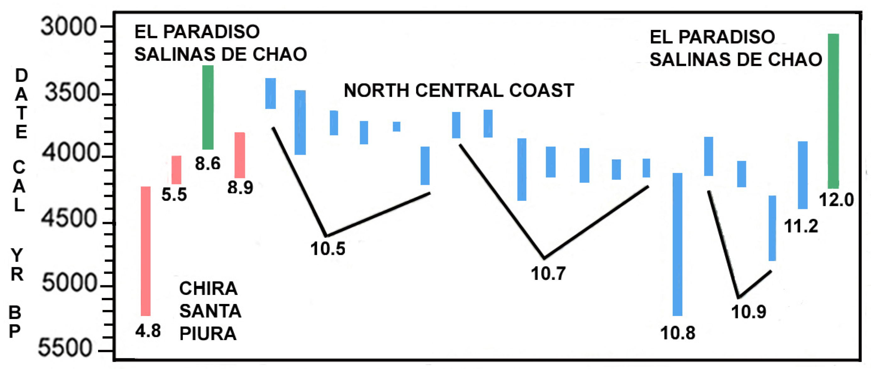
The beach ridge dates on the north central Peruvian coast and their locations are presented in Figure 6. Note that most of the earliest north central coast beach ridges appear in the ~2000–1600 BC date range, an important period for major site landscape changes, as discussed in the following sections.
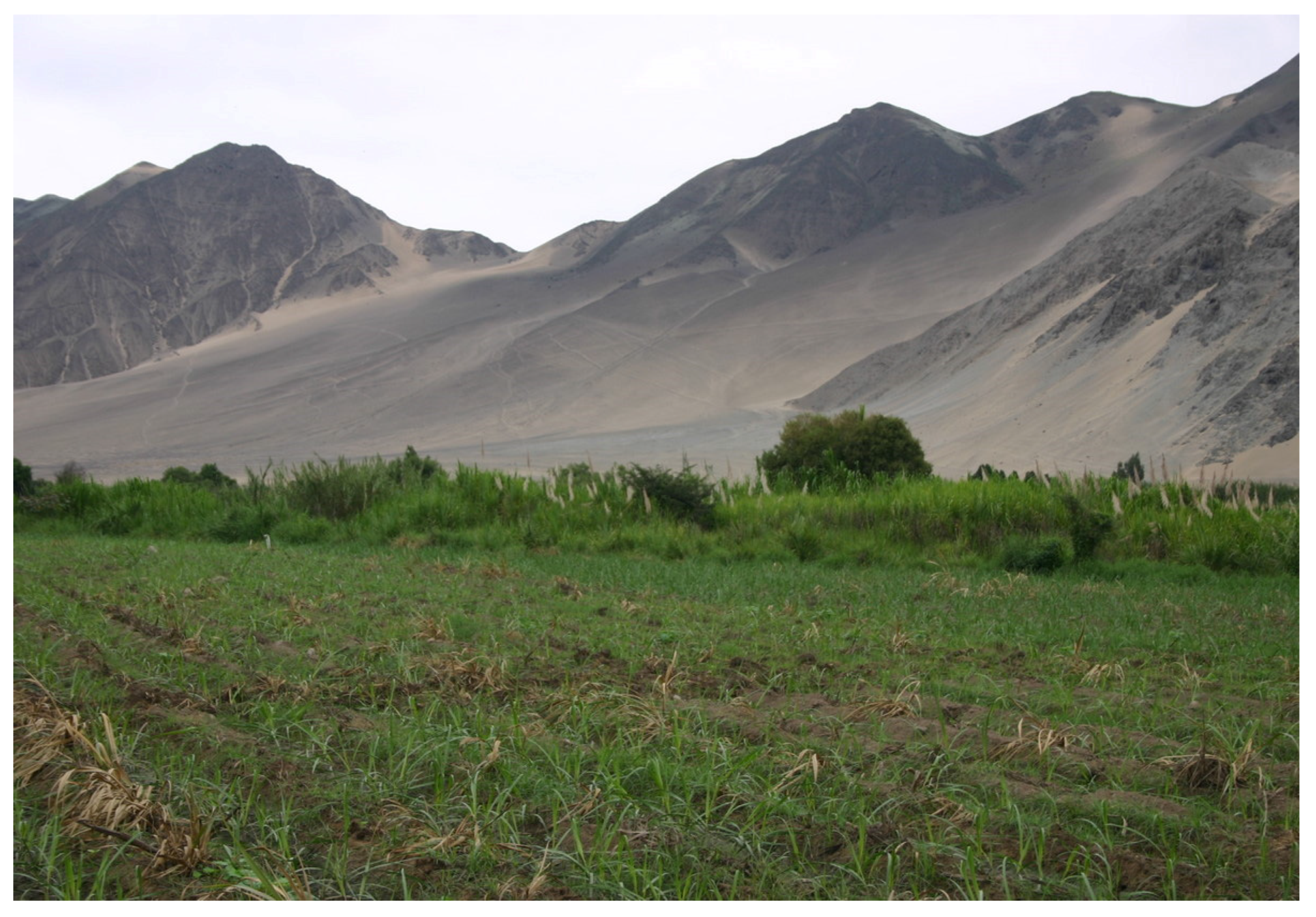
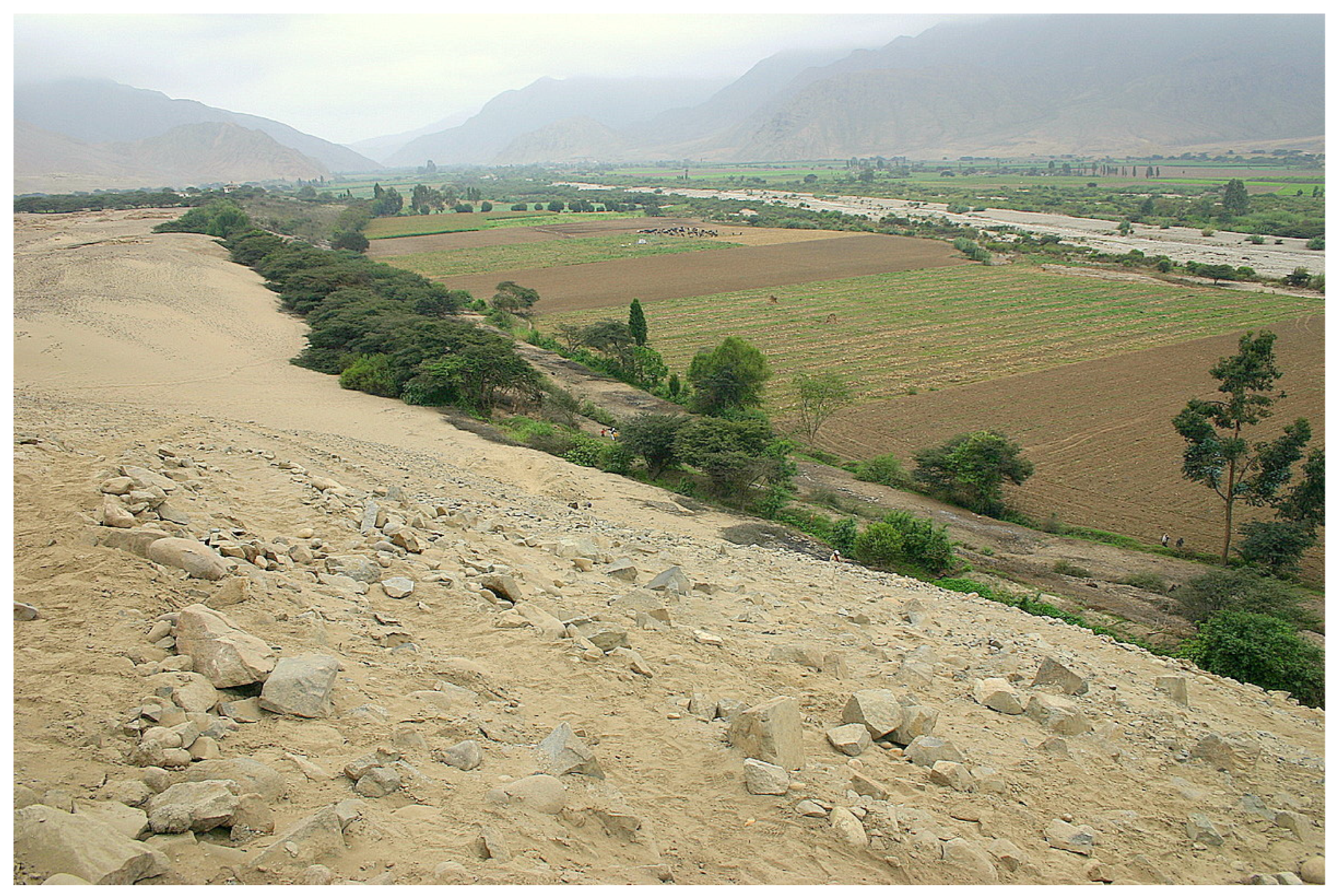
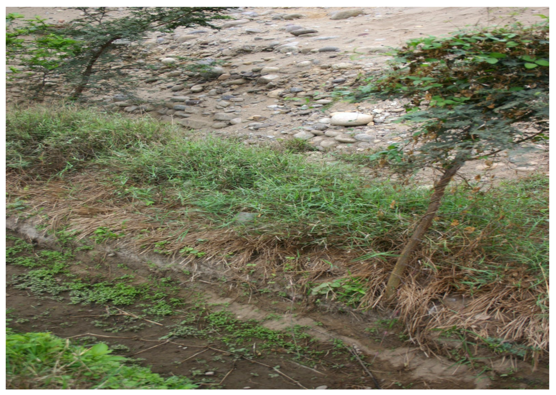
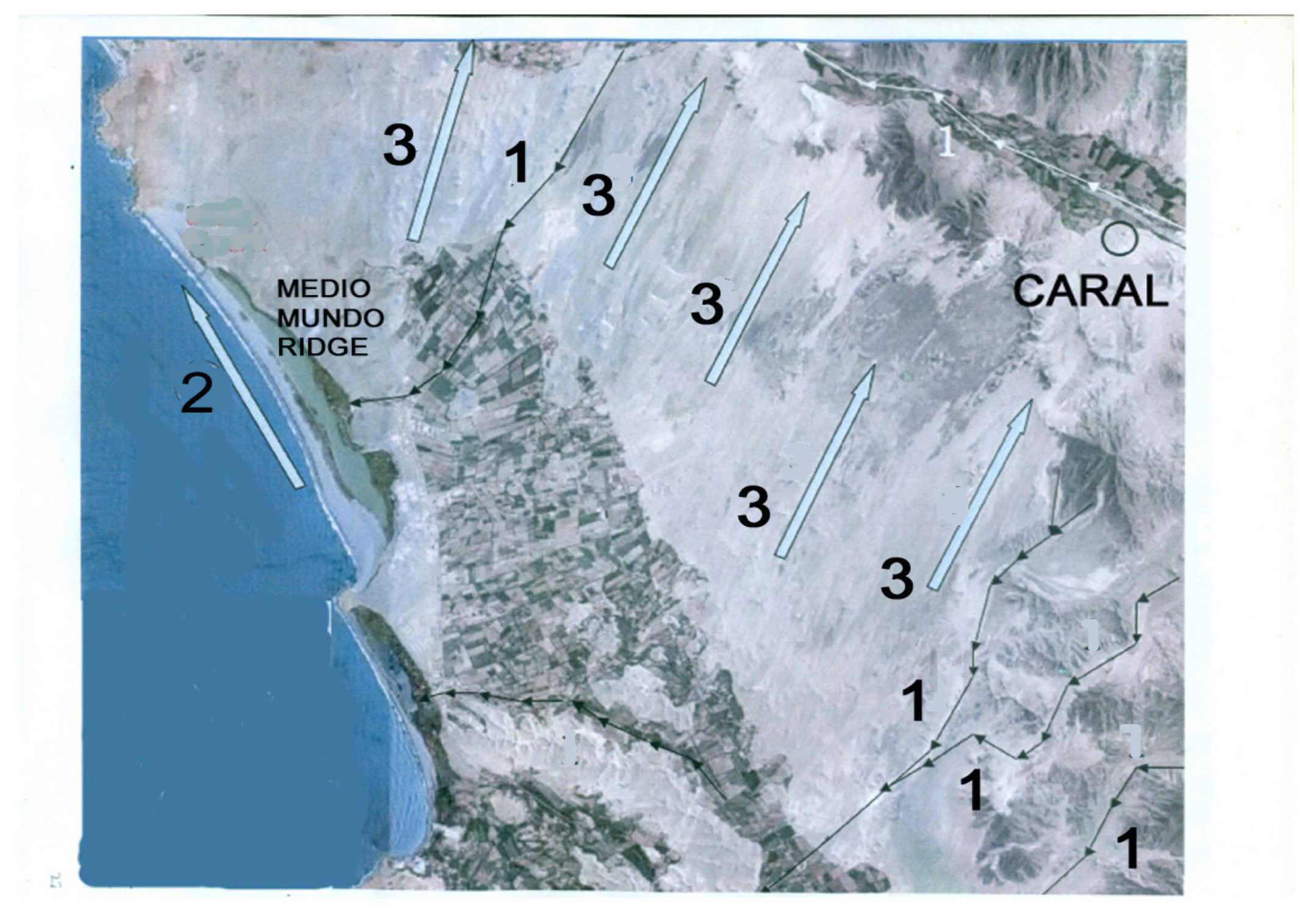
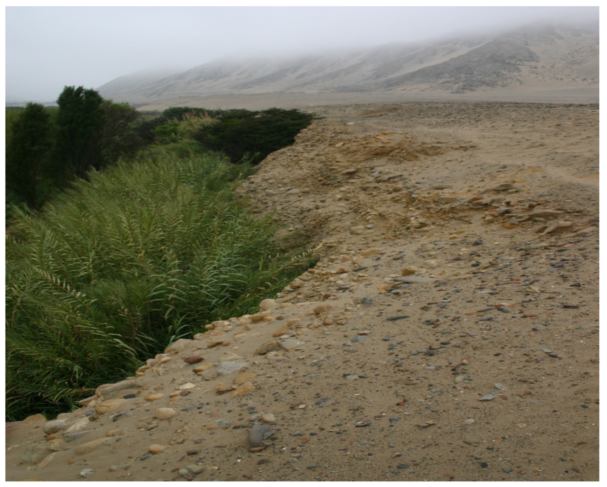
Strong coastal winds were the source of aeolian sand dune transfer to interior Supe Valley farming areas from the exposed beach flat areas, as noted by datable sand layers from the excavation pits. The aeolian sand transfer to interior Supe Valley areas originated from the vast sand seas in the Huara Valley south of the Supe Valley. Here, strong northwesterly winds carried sand across the low mountains separating the two valleys, to be deposited on the southern slopes and interior valley margins of the Supe Valley (Figure 7); this effect continues to the present day. As the formation of a major beach ridge from a major ENSO event is noted in the Late Archaic Period record, this initiates a chain of events that threaten both the agricultural and marine resource bases of both coastal and interior valley sites.
As flood-induced sediment transfer into ocean currents and the formation of beach ridge deposits are fluid mechanics phenomena, recourse to CFD FLOW-3D techniques [20] provide an insight into the sediment formation and deposition processes involved during major ENSO flood events.
To substantiate the CFD details of linear beach ridge formation, recourse to Google Earth satellite photographs of an actual linear beach ridge formation created after a recent major El Niño flood event in the Supe Valley and adjacent valley areas was apparent. The source of this new linear beach ridge on the north Peruvian coast within years after the large 1982 El Niño flood event then verifies that El Niño floods were the origin of a linear beach ridge formation over a relatively short time period. As beach ridge formation dates (Figure 6) are contemporary with large flood sequences occurring in the Late Archaic Period, the CFD analysis provides the rationale that fluid dynamics govern their formation and the geometry behind their linear shape. The fact that later multiple ENSO events occurring after an original beach ridge deposition event may influence dating results through deposition/removal of datable organic material is considered in Figure 6 to provide the mean and one sigma deviation band for an original deposition event. As a major El Niño event leads to a singular deposition ridge, the time sequence of sequential deposition events and the El Niño flood event that caused them can then be determined.
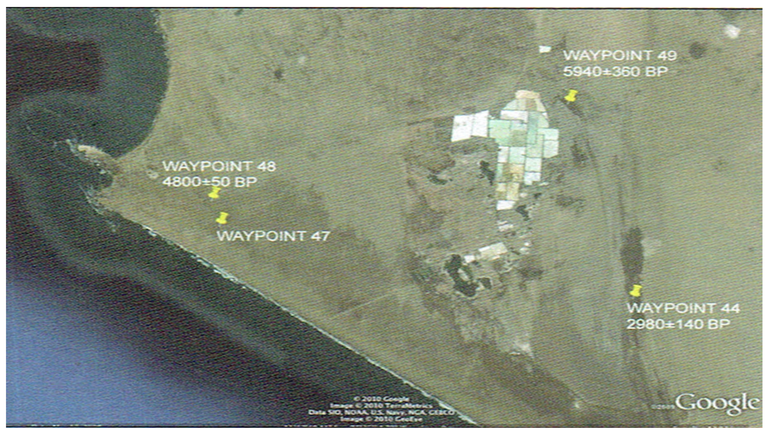
Coastal progradation stemming from sediment accumulation behind the barrier beach ridges is demonstrated by the C14 dating of different mollusk species known to occupy different shallow-water depths; when different mollusk species are found far inland, this indicates the coastline existing at that datable time (Daniel Sandweiss, personal communication). Figure 8 provides an example of shoreline littoral change over time related to the ENSO-induced events, as indicated by the dates associated with waypoint test pits.
The geophysical landscape changes affecting the agricultural and marine resource base of Late Archaic societies played a catalytic role in the fate of many Late Archaic Period sites. While research continues into the social, political and economic structure of Late Archaic Period sites and their response to climate change environmental stress to determine the details of societal structure modification [21,22,23,24,25,26,27,28], the present discussion focuses on the underlying fluid dynamics of beach ridge formation and the consequences of induced geophysical changes by flood and aeolian sand transfer events that affected the agricultural and marine resource base of Late Archaic Period sites.

3. The Supe Valley Caral Site

From previous research studies [29,30,31,32,33,34,35,36], it was recognized that complex societies based on irrigation agriculture and marine resource collection arose during the Late Archaic Period on the desert coast of north central Peru (Figure 1 and Figure 4). Labor groups built monumental structures of increasing size and complexity indicating the development of societal structural change with the evolution of a governing managerial class to direct construction projects involving consensual communal labor participation and organization. The earliest Norte Chico region platform constructions contained restricted access rooms [32], indicating some degree of social differentiation [21]. Recent research by Shady and associates [8,9,10,11,12,13,14,15] in the Supe Valley [30,31,32,33] demonstrated that this early cultural florescence took place in other north central coast valleys and grew to a size and complexity not previously recognized by earlier researchers. Recent research indicates that Late Archaic Period temples of the north central coast were abandoned by ~1800 cal BC [9,13,14,15,32,33,34,36,37], as indicated in Figure 2. Past this period, the Norte Chico region was never again a center for cultural florescence, although a small number of Formative and Initial Period agricultural sites in mid-Peruvian valleys temporarily reoccupied a few of the previously abandoned sites [36]. Several sites at the margins of the northcentral coast originated towards the end of the Late Archaic Period, with sites at El Paraíso in the Chillón Valley to the south and Las Salinas de Chao to the north, and survived hundreds of years well into the Formative/Initial Period as preceramic sites.
For the present analysis, the discussion is focused on Caral in the Supe Valley. The site is located 182 km north of Lima and 24 km inland from the city of Haucho on the central Peruvian coast (Figure 1). Figure 3 indicates major building complexes at Caral. A foundation element for the concentration of Supe Valley sites was an abundance of water for agriculture to support the valley population. Since coastal rainfall is limited to a few centimeters per year, Supe Valley water for agriculture was mainly supplied by springs originating from valley bottomland areas sourced by seepage water transferred from Sierra lakes and man-made reservoirs through valley geologic faults augmented by aquifer seepage from the Supe River; such systems are designated amunas (sierra runoff capture-pits and reservoirs to augment the valley groundwater supply). An additional water source amplification of the valley groundwater level originated from canalized lagoons and water reservoirs that formed in low-valley bottomland areas that penetrated the groundwater level (Figure 9, Figure 10 and Figure 11). These reservoirs, created from penetration of valley depression areas, had irrigation canals to lower valley areas to permit multiple-cropping to sustain valley population increases. As the near-surface water-table surface varies about one meter from the wet to dry seasons, many springs were canalized to irrigate specific bottomland agricultural areas devoted to specialty crops, including varieties of beans, squash and maize types, as well as many fruit varieties and industrial crops, such as cotton and gourds.
As the water-table height was sustained close to a permanent level, valley-bottom field systems (Figure 12) permitted multi-cropping to occur throughout the year. Other archaic Norte Chico valley sites (in the Nepeña Valley in particular) were likewise associated with functional springs and large dams traversing upland valley gullies to trap rainfall runoff water to provide off-season irrigation water for crops supplied only by canals emanating from intermittent river water sources. The typical reservoirs shown in Figure 9, Figure 10 and Figure 11 are of ancient origin and are still in use today to support extensive valley agriculture.

4. Early Canal Development in the Supe Valley

Figure 12 indicates the current Supe Valley bottomlands and irrigated areas served by high water-table agriculture and canals originating from springs and reservoirs located on valley bottomlands. The Ramped Canal of the Late Archaic Period age was constructed on the upper plateau sidewall (Figure 3, Figure 12 and Figure 13) that transported water from a Supe River inlet (Figure 14) to the western part of Caral and further on to the inland site of Chupacigarro on a channel built on top of a ramped mounded aqueduct structure. The careful surveying associated with the ramped portion of the canal and its continuance over many kilometers to the Chupacigarro site is notable, given its estimated early provenience at ~2500 BC. This canal system is one of the oldest aqueduct canals yet discovered in Peru and is notable for its length and low channel declination angle. Figure 15 indicates the totality of canal systems in the Caral plateau area.
Figure 15 indicates that the Ramped Canal extension was the water source for the canals on the Caral plateau as well as the water source for the older Chupacigarro site (Figure 4). Figure 16 shows the Ramped Canal path leading to the inland Chupacigarro site now largely buried by drifting sand. The Figure 3 Continuation shows the canal cross-section profiles located near the Supe Valley project excavation house Residential Area; although the source of water for the different canal cross sections remains to be determined by further excavation, it is likely that the water source is from a branch canal from a Ramped Canal extension that supplied an early transverse ‘red line’ canal running laterally across Caral as indicated in Figure 3. Presently, a large erosion gully divides the north upper and south lower areas of Caral so traces of an earlier transverse canal segment are no longer present to extend the data obtained from the cross-sectional profiles shown in Figure 3 Continuation. Figure 16 shows the remains of the Ramped Canal extension to the Chupacigarro site now buried in sand; traces of its path are evident from a filled earth upstream aqueduct supporting the canal that have been recently excavated. The Supe Valley had (and still has) the advantage of a continuous water supply to source agriculture throughout the year, while adjacent Late Archaic Forteleza, Pativilca and Huara Valley sites only had access to intermittent rainy season runoff for canal irrigation.

5. Late Archaic Period Climate Change Evolution

Excavation data from Caral [8,9,10,11,12,13,14,15] indicates that marine products transferred from coastal sites were plentiful at interior valley sites, as evidenced by large marine shell and fish bone deposits at locations within Caral. Gourds and cotton grown at interior Supe Valley sites were traded and used for fishing nets and lines at coastal sites indicating that cooperative trade underwrote the valley’s economic base. Ancient Supe Valley farming products within coastal valleys included guayaba (psidium guajava), pacae (inga feuillei), achira (canna edulis) as well as avocado, beans, squash, sweet potato, maize varieties and peanuts, attesting to the wide variety of comestibles available for coastal trade. The identification of agricultural products results from current seed-extraction analyses. The key to the importance of Caral and subsidiary Supe Valley sites is that they comprise the earliest New World example of an integrated valley economic unit deriving benefits from valley bottomland spring-sourced canalized irrigation systems, a plateau agricultural ramped canal system (Figure 15) and amuna groundwater-level water supply systems for agriculture. This, together with multiple stone-faced pyramid structures within a complex city architectural environment (Figure 3) originating in and past ~2500 BC, designates Caral the place in history as the first city of ancient Peru. The Late Archaic Supe Valley inland and coastal sites initiated and characterized by complex societal development would have developed further complexity, perhaps up to state level for the Norte Chico sites, were it not interrupted by large-scale ENSO environmental-change effects in later phases of its existence.

6. Sea-Level Stabilization, El Niño Floods and Beach Ridges

Sea-level stabilization between 6000 and 7000 cal BP set the stage for Late Archaic Period developments [5,19]. The onset of El Niño rains about 5800 cal BP after a mid-Holocene hiatus had implications for the social processes that found expression in the temple centers of Supe and the surrounding valleys [4,5,18,19]. By ~1500 BC, several preceramic north central coast sites were abandoned (Figure 2), suggesting a common influence of a large-scale environmental change affecting all areas of the Peruvian northcentral coast. Prior to ~1800 BC, the agricultural and marine resource base developed over time in a relatively stable climate period. Accretion processes influencing the geomorphology of the Peruvian north central coast littoral and inland valleys were determined by the deposition of large sediment loads originating from El Niño flood events interacting with oceanic and wave-induced near-shoreline northward flowing currents, together with major aeolian sand incursion events from beach flat areas and wind-borne sand from the southern Huanca Valley; these effects challenged the continuity of the Supe Valley sites. In the later phases of the Late Archaic Period sites, around ~1800 BC, significant changes in the geophysical environment were brought about by a major ENSO flood event and amplified aeolian sand transfer into the interior valley lands, this challenged the continuity of the valley agricultural and marine resource base. Sediment transport and offshore sediment deposition patterns into the Pacific offshore seabed depend upon El Niño flood magnitude, rainfall duration and spatial distribution, valley landscape geometry, landscape soil types, sediment and slurry physical properties, seabed shelf angle, coastal uplift/subsidence and geometric details of river channels and watershed collection areas. Flood sediment load is influenced by earthquake activity that produces large quantities of loose surface material available for runoff transport. Large rainfall events cause changes in the equilibrium profiles of drainages affecting sedimentation and drainage patterns that influence the amount of flood-transported sediment and the formation of offshore sediment deposits in the form of beach ridges. Sediment transfer processes result not only from El Niño flood events, but also from rivers that flood during rainy seasons from high Sierra rainfall runoff and carry sediment into ocean currents and/or deposit sediments behind beach ridges which served as barriers to river drainage into ocean currents. North of 9° S, the continental shelf abruptly widens, and extensive beach ridge plains exist, formed from sediment deposits that trail north from the largest rivers of Peru, which are the Santa, Piura, Chira, and Tumbes rivers. Beach ridges formed from flood sediment slurry deposits are present at Colán, where El Niño rains have eroded an uplifted marine terrace [3,37]. All the northern beach ridge plains originally consisted of eight to nine separate beach ridges, and each plain formed well after late Holocene sea-level stabilization. The beach ridge sequence indicates that the furthest ridge away from the current shoreline formed from the earliest flood event that also altered the coastline shape before the beach ridge. A later flood event acting on the earlier altered coastline littoral, deposited a further beach ridge closer to the shoreline with a further slurry deposit addition ahead of the latest ridge to alter the shoreline littoral. Now there is influence of the later flood event and beach ridge formation on the earlier beach ridge due to erosion and deposition activity to further bury it with later slurry and sand deposits. As later flood events occur, a progression of beach ridges forms together with deposition increments to add to the shoreline. Beach ridge sequences occurring over time continue to modify and add to coastline extension. This process, when subject to CFD analysis in a later chapter, indicates that this sequence of events can be recreated through fluid dynamics analysis.
South of latitude 9° S, where the continental shelf is narrower and the seabed angle steeper [35], Figure 6 shows dated beach ridge formations from a 4.8° to 12.0° south latitude on coastal Peru. The earliest beach ridge dates are from Chira, Piura and Santa coastlines, while the remaining dates are for beach ridges at Salinas de Huacho and El Paraíso, and are shown with their latitude positions in Figure 6. The earliest beach ridges appear at far southern latitudes at 4.8° S, with later ridges occurring to the north. This trend implies that early El Niño activity as a source of deposition material was prevalent after ~5500 BC (but not earlier), consistent with late Holocene sea-level stabilization.
As the shoreline transgressed during post-glacial sea-level rise, prograding beach ridge plains could not form. Subsequent sediment deposits from aeolian sand transfer, intermittent flood and oceanic current sources and silt entrained in farming drainage runoff over millennia promoted bay infilling to constitute the present day shoreline. Only with the relatively stable sea level of the last 6000 years could beach ridge plains form and alter landscape geomorphology and littoral resource suites along the coast. Sea-level stabilization is linked to climate change in the Pacific Basin, with El Niño events starting after a hiatus of about three millennia [5,19], during which northern Peru was characterized by annual warming and a fishery composition absent of small schooling fish, such as anchovy and sardine. With ecological changes accompanying the northward extension of the Peru Current at the start of the Late Archaic Period, small fish species began to dominate the fishery, calling for different capture strategies that required intensive production of cotton nets, fishing lines and gourd floats consistent with cotton dominant among domesticated plant assemblages in all the Late Archaic coastal centers [1,9,10,11,12]. The founding dates of Áspero, Vichama and Bandurria on the shoreline of north central coast valleys preceded dates of the inland Late Preceramic temple centers [32], suggesting that access to irrigated agricultural lands was linked to intensified production of cotton and gourds and was key to the integrated economic model existing in the north central coast area.

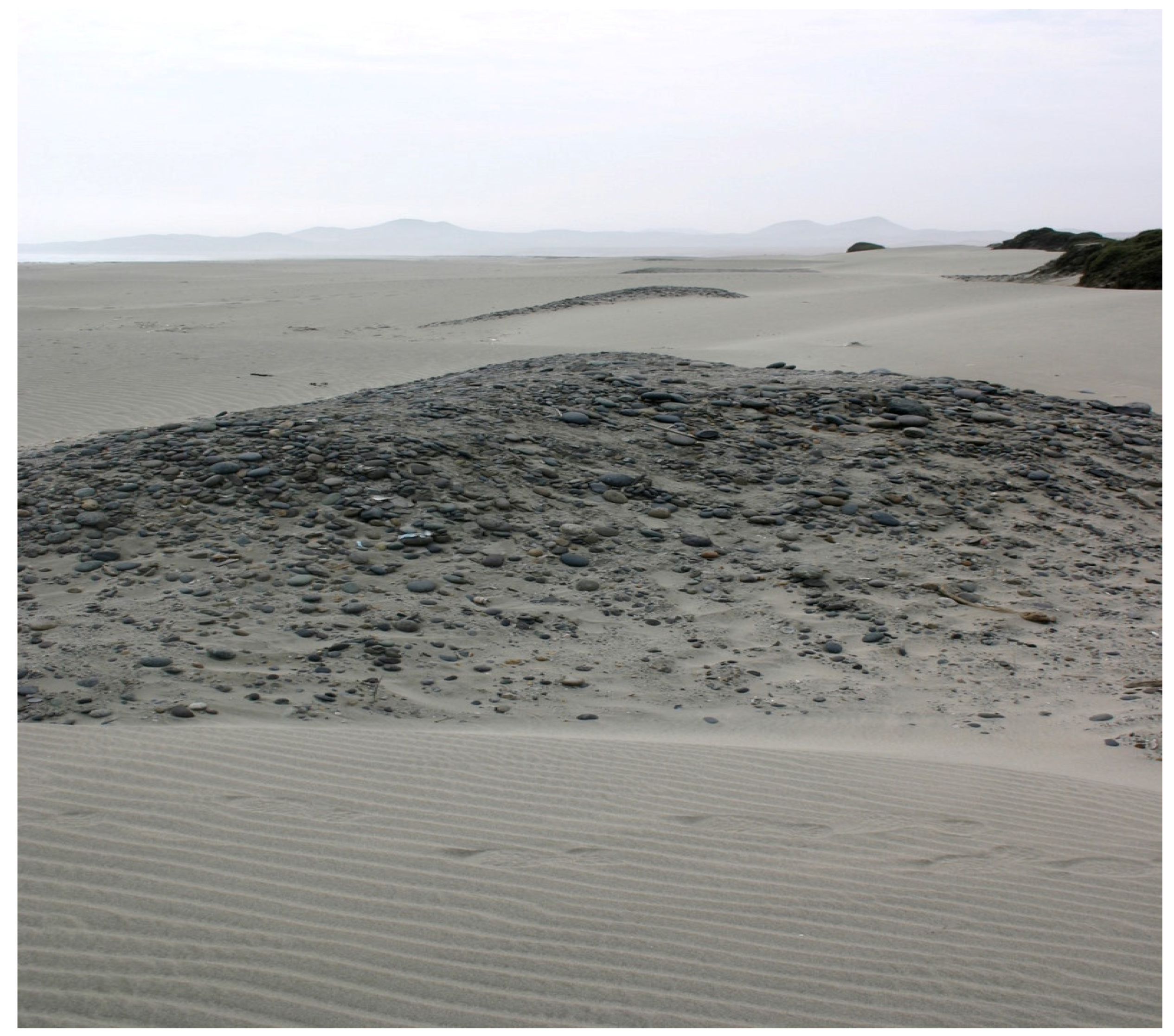
7. Geophysical Origins of Beach Ridge Formation

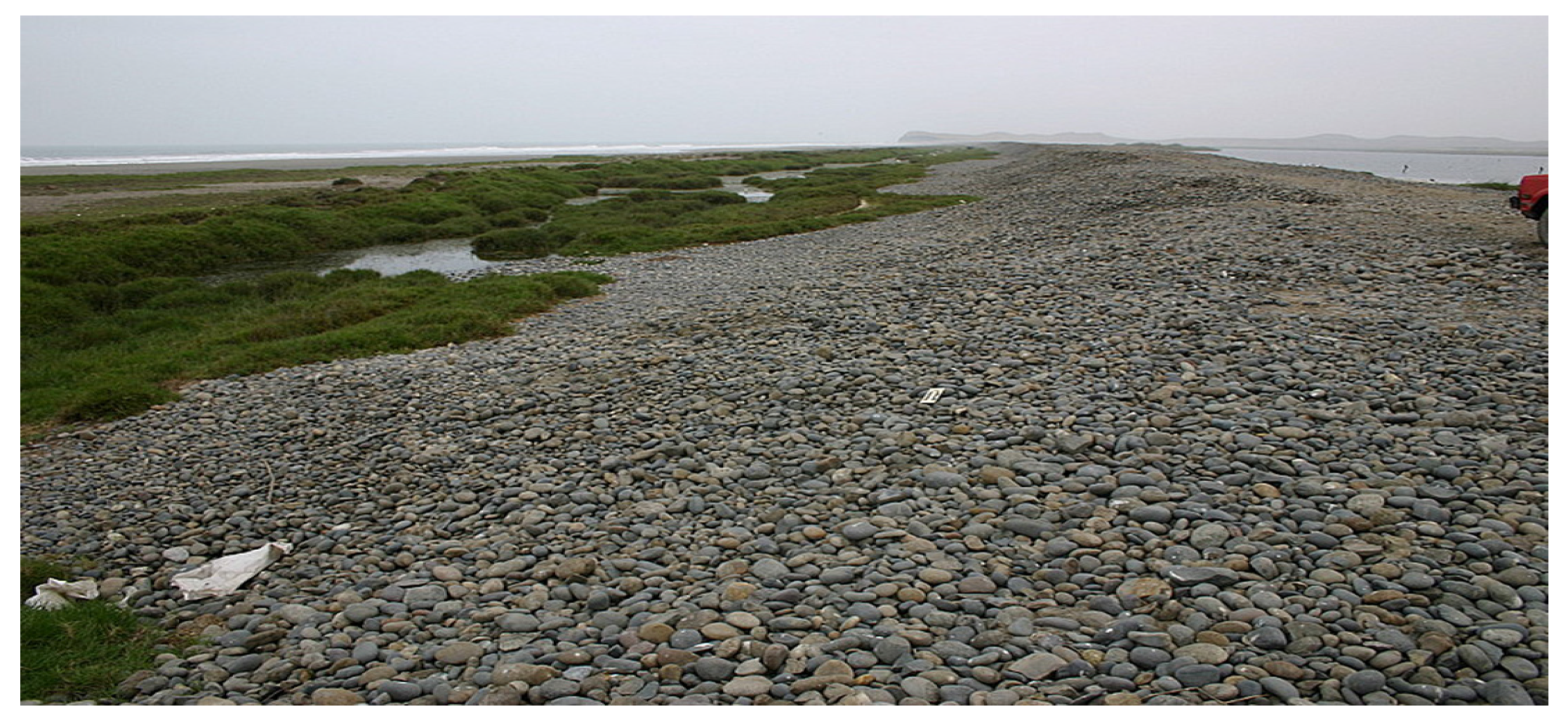
Various types of beach ridges observed at different locations along the Peruvian coastline (Figure 17 and Figure 18) result from the complex interaction of river-borne El Niño flood sediments with oceanic and wave action currents to produce beach ridge sequences.
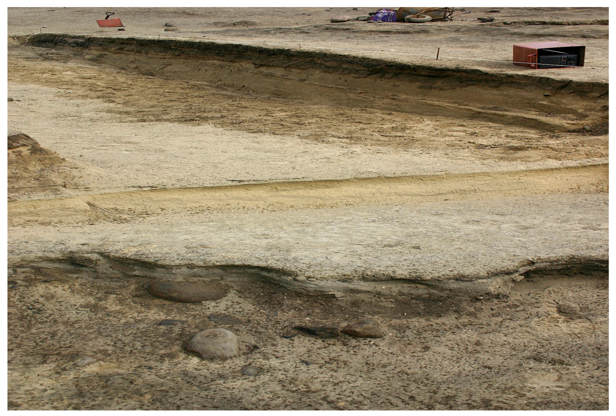
 Figure 19 and Figure 20 illustrate inland deposition layers originating from the same events.
Post-sea-level stabilization, sediments and aeolian sand transfer began to accumulate west of the Quaternary sea cliff that marks the back of the original Supe Bay and the smaller Albufero and Medio Mundo inlets to the south and the Paraiso Bay, south of Huacho. In time, narrow beach ridges developed from a series of ENSO events inducing sand accumulation behind each ridge; this period was followed by stable progradation that buried each minor ridge by aeolian sand transfer and dune formation. In about ~1800 BC, a major ENSO event created the large Medio Mundo beach ridge along ~114 km of coastline sealing off former fishing and shellfish gathering bays. This event created large scale sand flats that accumulated behind beach ridges and promoted the large-scale aeolian sand dune inundation of coastal plains and inland valley areas compromising a significant part of the agricultural base of the Supe Valley society. The coastline geomorphic change affecting the marine resource base of Norte Chico societies was affected by a combination of flood sediment accumulations amplified by aeolian sand transfer processes that infilled previously established fishing and shellfish gathering areas. Although river-borne sediment constitutes a major source of slurry transport during flood events, additional opportunistic drainage paths originate from areas between river valleys to provide addition sediments to ocean currents. Again, many north central coast preceramic sites terminated occupation by ~1800 BC, suggesting that a major geophysical change over a wide coastal area compromised their economic base, thus, the importance of understanding the geophysics of beach ridge formation and its consequences on the agricultural base of archaic societies. The abandonment of major preceramic sites, with limited Formative Period reoccupation of a limited number of former sites, motivates the discussion to follow as to what these changes were to the economic base of archaic societies and their relation to beach ridge formation.
Tectonic coastal uplift rate differences from north to south latitudes influence beach ridge typology. A significant uplift rate may strand and separate sequent ridges from individual flood events, while, in the absence of uplift, single subsea ridges form and sediment deposits accreting landward from the ridge appear to strand a ridge above the land/water interface. Additionally, offshore undersea ridge formation may alter the deposition history of subsequent later ridges by altering seabed shape, river mouth geometry and river positional shifts. Later flood events may also erode and erase previously deposited ridges, and aeolian sand incursion may bury segments of earlier ridges; all these factors, operational over millennia, influence the remains of ridges. The relation between flood events, beach ridge formation and agricultural landscape change, as demonstrated by CFD computer-modeling results, are subsequently detailed to illustrate their connectivity to provide the basis for conclusions supporting the observed geophysical transformations of Supe Valley agricultural and littoral areas in Late Archaic times.
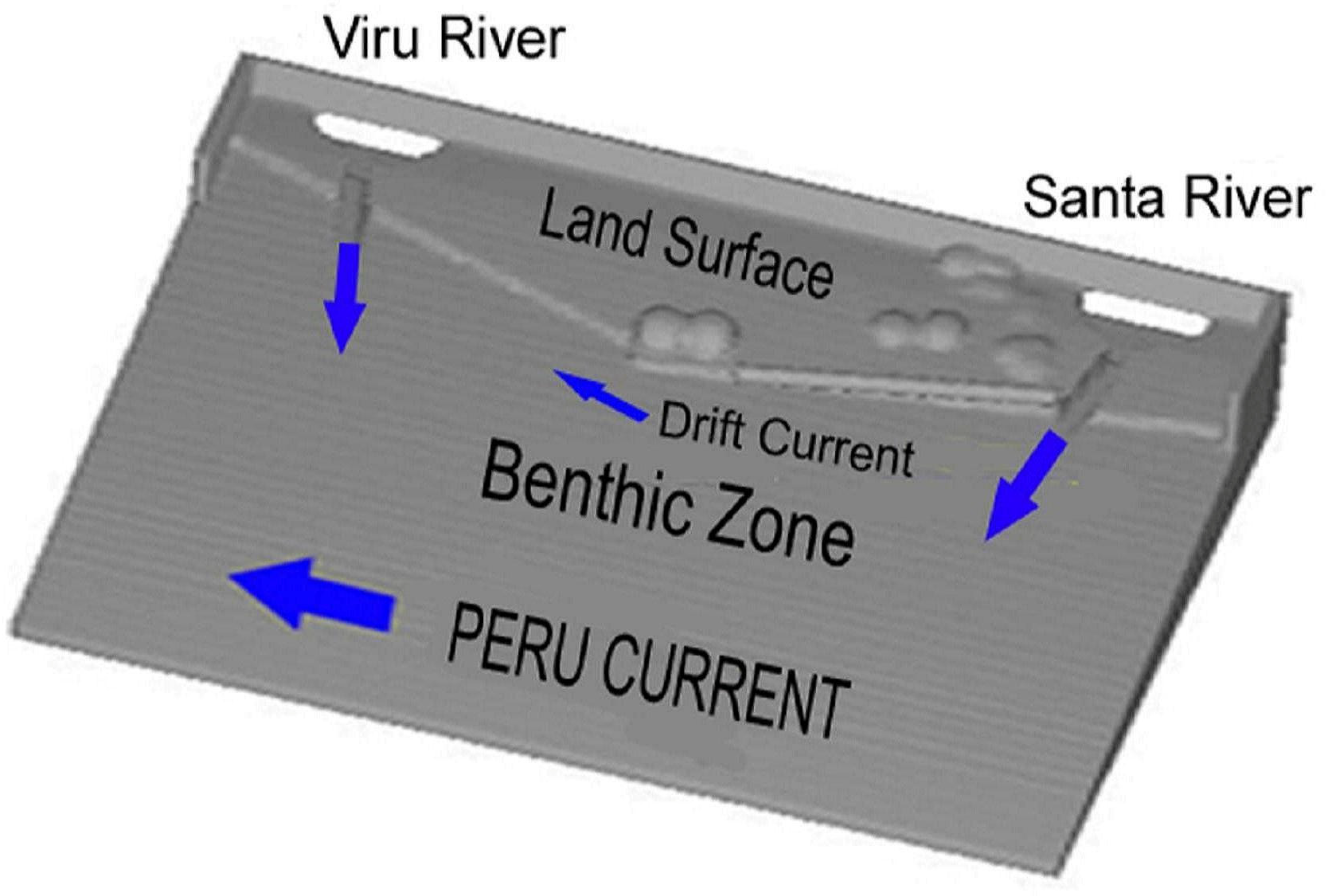
To illustrate the fluid mechanics basis of ridge formation, a three-dimensional computer model of the Peruvian coast from Santa to Viru Valleys was created (Figure 21) using FLOW-3D software [20]. The minor intermediate Chao Valley drainage between the Santa and Viru Valleys was omitted from the CFD model, due to its minor effect on the beach ridge formation compared to the major Santa and Viru river drainages. The intent of the CFD calculations are to show the fluid mechanics transformation of flood slurry movement into ocean currents during an El Niño event that can produce an extensive linear beach ridge; this linear beach ridge formation is unexpected and, intuitively, one may not associate a chaotic flood event and chaotic slurry transport into ocean currents as the source producing a linear beach ridge structure.
The use of a CFD model is made to demonstrate how fluid dynamics can duplicate observed geophysical events that occur during a major El Niño flood event. Details from the CFD analysis can uncover the geophysics behind field observations and help to understand nature’s role in the formation of deposition and erosive landscape structures observed in field studies. The CFD model area in Figure 21 was selected due the availability of data [4,6,7] in the Santa-Viru coastal zone that allows for the qualitative verification of modeling results compared to field observations. It is expected that the CFD results obtained on beach ridge formation in the Santa–Viru coastal area are qualitatively similar to the ridge development in the nearby Supe Valley coastal area, given that the same fluid mechanics-based geophysics applies. Shown in the Figure 21 CFD model are the sloped offshore seabed and coastal land areas, with southern Santa and northern Viru River Valleys providing known data as to beach ridge formation from an El Niño flood event where sediment conduits to the ocean current are the source of beach ridge formation. During a major flood event, slurry material from the eroding landscape is transported into local rivers and conducted into ocean currents. The interactive geophysics of the slurry interaction with ocean currents and the settling of the slurry to form a beach ridge is then predicted by CFD analysis. Inherent to the CFD analysis are the details of the formation of landscape change from erosion/deposition events as well as beach ridge formation processes; while field observations only record the results of flood events, CFD analysis provides the fluid dynamics mechanisms behind their creation.
The composition of flood-transported slurry material is drawn from the size, gradation, cohesivity and stratification of erodible bank sediments over the coast-to-mountain area watershed and surface material washed into the streambed. Profiling a selection of beach ridge cores provided an indication of the percentage by weight of different-sized sediment particles. High concentrations of large-sized particles (gravel and small boulders) in the wash load damp slurry turbulence, increase the apparent viscosity of the slurry flow and reduce their settling slurry velocity, enabling the early settlement of coarser grains and a larger bed-material load compared to finer grade slurry material. While only river-borne sediment transfer is considered for CFD model purposes, additional opportunistic drainage channels and ephemeral streams develop during flood events, leading to sediment transfer to lower coastal areas that contribute additional sediment to ridge formation/accretion processes and landscape change.
A two-fluid CFD model represents slurry sediment–ocean mixing interaction. Fluid 1 is ocean water characterized by kinematic viscosity ν1 and density ρ1; Fluid 2 is sediment-laden flood water slurry characterized by high values of kinematic viscosity ν2 and density ρ2 compared to ocean water. Here, ν = μ/ρ, where μ is the absolute viscosity. Depending on the sediment load of the floodwater, ν21 can range from 1 (no river-borne flood sediment) to 103 (heavy river-borne sediment loads with very high absolute viscosity).
For purposes of demonstrating the fluid dynamics phenomena involved, a selection of input properties typical of observed sediment composition is presented. Due to local variations in sediment composition, only a generic, illustrative slurry composition is presented that is typical of the conditions in the area of study. Model river-current velocity is set to a value to induce riverbed erosion and sediment transport mobility. For silt (<0.001 mm diameter, ~15% by weight), sand (0.1 mm diameter, ~30% by weight), gravel (0.1 to 5 mm diameter, ~35% by weight) and an assortment of rock-particle sizes (5 mm to 100 mm diameter, ~20% by weight) composing the sediment solids, estimates of both properties and critical mobility stress levels are provided by [2,38,39,40,41,42] to substantiate the typical υ21 values used in the CFD simulation. The northward offshore current velocity is set low to represent near cessation during El Niño events. A near-shoreline, northward drift current is induced from the difference between the incoming wave vector angle and a normal vector to the shoreline. The model sea level is set to the stabilized ~5000 BC level. By using model length scales (model area is ~1035 km2) and slurry velocity ranges approximating actual values, Reynolds and Froude numbers are duplicated, and the computer time is equal to the real beach ridge formation time. The results provide a lower-bound time to determine the flood duration required to deposit beach ridges of known sizes and volumes. Note that the early Quaternary version of the shoreline consisted of deep river-downcut bays consistent with the lower sea level, and that wave-cut bluffs (now inland from the present-day accreted shoreline) resulted from rising sea levels, the subsequent deposition of sediment over millennia is from floods, river, and aeolian sand transport that served to infill this landscape. The present computer model is qualitatively representative of an intermediate stage in this landscape transition process during a flood event. The results of the CFD computations then represent the early stage of beach ridge formation: subsequent millennia of accretion and erosive effects then serve to represent current day observed shoreline patterns.
The results of Santa–Viru coastal zone simulation are subsequently summarized. This zone has a well-documented ridge sequence [4,6,7] and is used to test computer predictions with observed geomorphic features that have survived from early creation stages to present-day stages. 
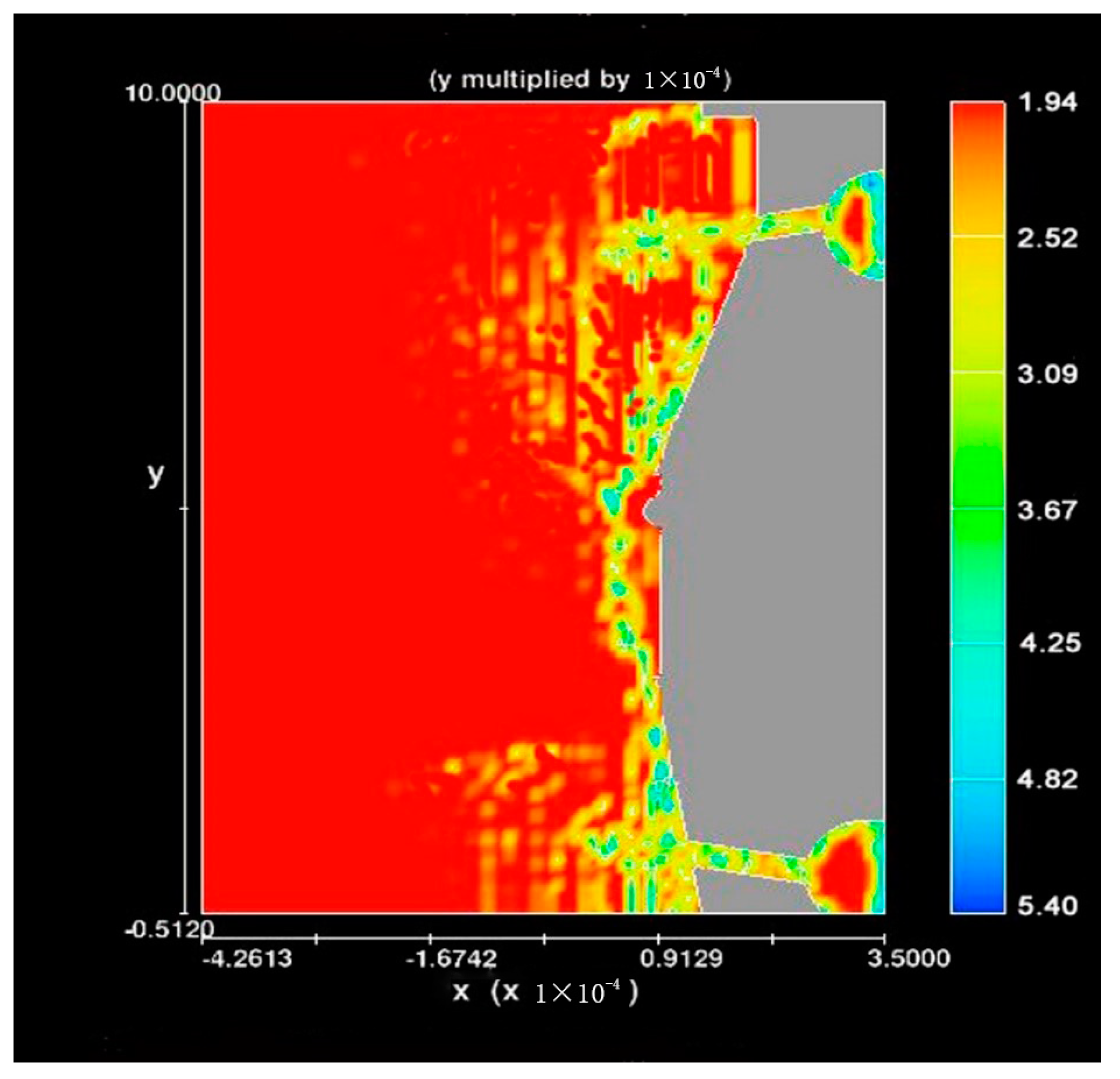
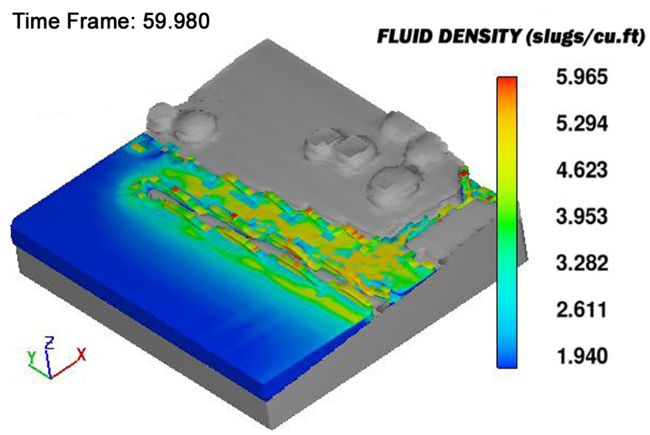
Figure 22 shows the initial offshore sediment deposition density distribution from a single, large El Niño flood pulse concentrated in the Santa–Viru Valley area; the density scale ranges from 1.94 slugs/ft3 (1000 kg/m3) for seawater to 5.40 slugs/ft3 (2783 kg/m3) for heavy flood slurry. For a lower-limit slurry grain size of 0.01 mm, erosion, transport and entrainment are maintained from 0.001 to >10 m/s velocity; for a grain size of 10–100 mm, erosion, transport and entrainment are maintained for >1.0 m/s velocity [2,42]. On this basis, a river near-surface velocity is assumed to be ~1.0 m/s, for purposes of demonstrating the sediment–ocean current mixing and deposition process by CFD simulation. Since slurries of the type encountered in flood debris are highly non-Newtonian power law fluids, shear thickening with an increasing shear rate is expected. Here, a higher apparent viscosity applies, and the kinematic viscosity proposed is used for purposes of the demonstration problem. An observation made of highly viscous slurry motion in river valleys during the catastrophic El Niño flood event in 1982 during my stay on the Peruvian north coast gives credence to the slow slurry velocity used in CFD calculations. Although the velocity profile for Newtonian, viscous channel flow can vary from that determined for non-Newtonian slurries [40], for the present demonstration problem, the slurry is assumed to have a constant absolute viscosity, rather than a shear rate dependent value. The offshore Peru Current velocity is approximated to be ~5 cm/s and the coastal drift current is ~3–5 cm/s, with local drift velocity values computed based upon the geometry of the coastline (Daniel Sandweiss, personal communication). The elapsed time is ~35 hour of continuous El Niño flood activity, with ν21 = 103 indicating a high absolute viscosity, heavy sediment load carried by the flood currents. The offshore average seabed slope is ~0.15° from horizontal for the Santa–Viru north central coast area; the offshore seabed slopes after 3800 BC are estimated from Barrera [35] Figure 11 and Pulgar Vidal [40], as well as the values for oceanic current velocity.
Figure 22 indicates the formation of a long sediment deposit beach ridge on the coastline; the scale shades represent the mixture density of seawater and the initial flood slurry density emanating from the rivers. Notable is the early deposit of (green) heavy materials and the further offshore deposit of lighter (yellow-orange) slurry component materials. The northward current, together with the near-shore drift current, enhances the northward deposition of the sediment. The predicted high density, larger size sediment compositions appear along the ridge length, as observed from field studies [4], while the transport and sorting of sediment fines continues in time from wave-induced drift currents. For steeper seabed angles, the formation of a close-in ridge deposit to the shoreline occurs; here, a steeper seabed angle results in a greater sea depth closer to the shoreline and, as resistance to a sediment particle’s forward motion is related to the hydrostatic pressure encountered on its front projected area (in addition to viscous drag and dynamic pressure effects), sediment deposition occurs more rapidly for steeper benthic seabed angles.
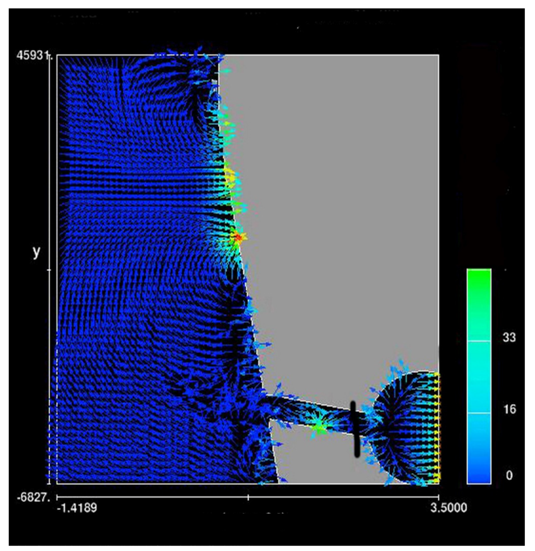
A velocity vector plot (Figure 23) shows that the out-rushing sediment stream creates a flow reversal pattern when encountering ocean and shoreline currents, leading to deposits of lighter sediments back towards the shoreline where low drift velocities prevail. The ‘U-turn’ of the sediment stream is consistent with the path of least resistance of small and intermediate sizes, low-inertia sediment particles that alter the direction away from the increased hydrostatic pressure resistance encountered further from the shoreline. As offshore Peru and drift current directions are not aligned, the agitation and transport of the deposited fines cause a gradual northward ridge extension over time. Of interest is the disturbance of the ocean current both near and far offshore by the river borne slurry injection as well as currents that show northward flows from the river mouth that influence sediment deposition far north of the river mouth. The CFD calculation results provide a qualitative relation between an El Niño flood event and details of ridge formation: floods with large sediment loads can produce extensive near-shoreline subsea deposits whose size depends upon flood duration and amount/type of sediment available for transport by ocean and drift currents.
For Figure 22, the density of the slurry stream is 5.2 times that of ocean water. Many beach ridges observed in the Santa–Viru sequence are composite, indicating large accumulations from multiple, closely-spaced-in-time flood events; where aggraded sediment material separates ridges, a longer time interval had occurred between major flood events: the use of C14 dating on organic material within the ridges then present the dating of ENSO flood events. Beach ridges contain mollusk shell material indicative of seabed sediments being agitated and entrained during flood events. Once the ridges are stranded on land by surrounding aggraded material, later flood events create new subsea deposits that accrete material to create the ridge sequence noted in the Santa–Viru coastal area, where shallow seabed angles prevail (Figure 23 and Figure 24 illustrates this occurrence). South of this zone, where steeper seabed angles prevail, a composite, a unitary ridge type is predicted. Situations occur in which loose surface sediment is minimal and/or the surface runoff water velocity too low to carry or erode sediment, so that ridge formation is minimal or absent during lower-magnitude flood events.
Figure 24 shows what happens when a later flood event occurs after an earlier beach ridge deposit. Trace sediment deposits occur seaward and inward from the earlier main ridge; this trace ridge alters the river outlet shape and influences river discharge patterns (Figure 22, Figure 24 and Figure 25), as well as altering the local seabed slope from the settled sediment, all of which alter conditions under which subsequent ridges form. In Figure 24, a trace subsea ridge (yellow-brown) was formed close to the shoreline behind a (grey) ridge formed from a prior flood event. The inner sediment deposit is the source of bay infilling and marsh creation from rainfall, river deposits and later flood events. The outer sediment deposit is the source of coastline shape alteration from sediment deposits. A sequence of distinct ridges form from later flood events that gradually accrete sediment between them to both form a ridge sequence typical of that observed in the Santa–Viru area together with alteration of the coastline shape. Based on the observations of the Santa–Viru ridge sequence formed from datable multiple flood events, computer predictions provide the underlying fluid mechanics mechanism to explain ridge formation and their observed orientation, shape, width and composite nature. From Figure 24, previous flood deposition events affect and influence both the inland and offshore deposition history of later flood events that contribute to shoreline growth and shape change as well as river mouth shape. This effect is manifest in Figure 17 and Figure 18 which show inland beach ridges buried by sand aeolian sand deposits and many flood erosion events millennia after their creation.
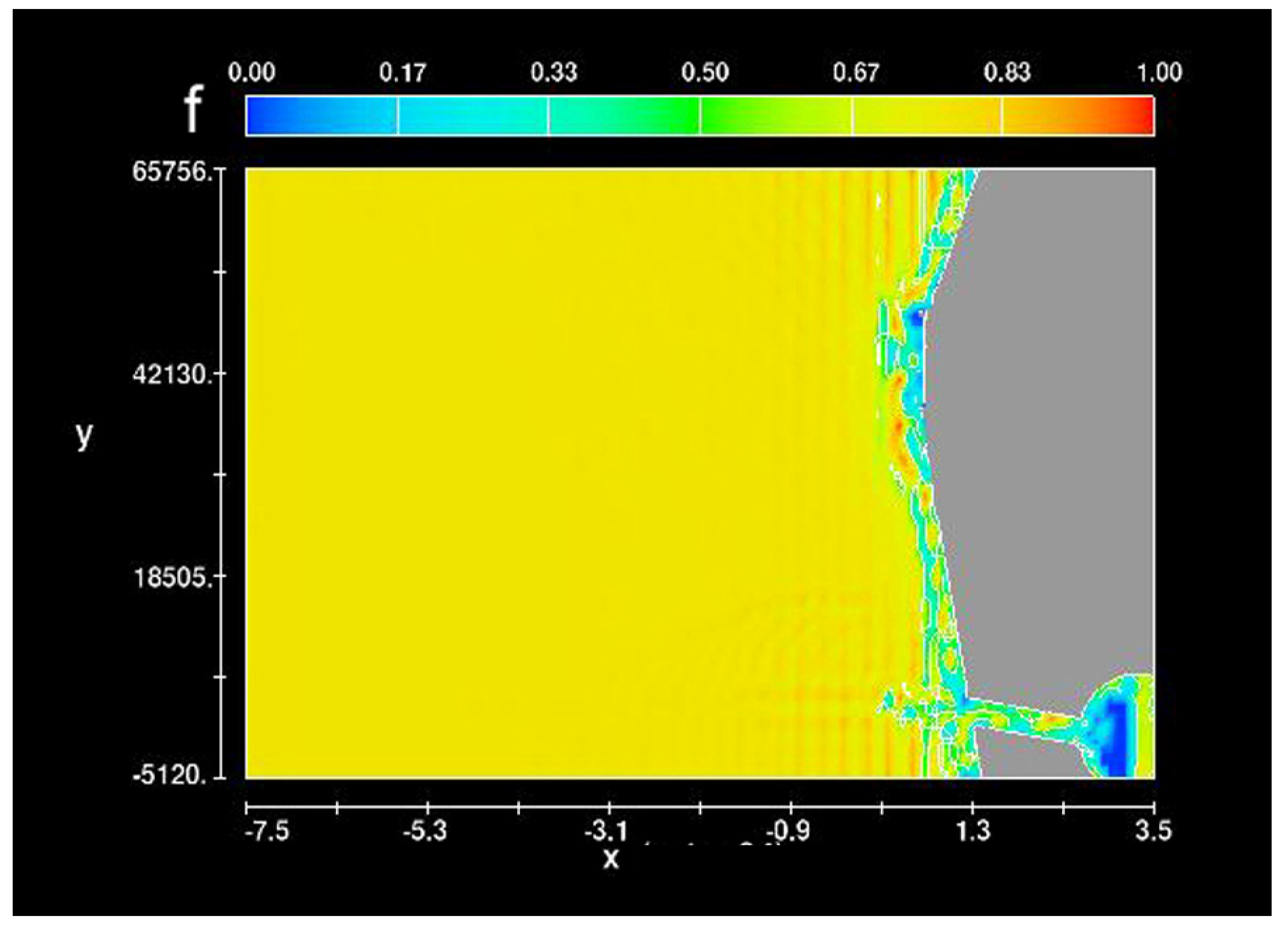
Figure 25 represents a case in which the seabed slope in the Supe Valley area from the Huara to Forteleza Valleys is steeper than that for the Santa–Viru calculations shown in Figure 22. Figure 26 how a flood deposition event alters the coastline shape deposition event—this is the fluid mechanics version that underlies coastal shape changes shown in Figure 8. The results indicate ridge deposition closer to the coastline, owing to the higher hydrostatic pressure close to the shoreline encountered by low-mass, low-inertia sediment particles; here higher-pressure drag resistance leads to rapid particle settling closer to the shoreline. Subsequent flood events combine to produce a unitary, composite, multi-layered ridge, which is continually reworked and redistributed as currents shift deposits and extend the deposition length.
It is noted that, although many of the above results shown apply to the Santa to Viru Valley coastal area, the results show that large beach ridges well over 50 miles in length can be generated by major El Niño flood events that involve large portions of the Peru coastline over the length scale of the CFD model. The Santa to Viru Valley distance of ~100 km is on the order of the Pativilca–Supe–Huara Valley distance and, typically, major El Niño flood events cover very large portions of the Peru coastline. CFD results applied to similar coastline areas can generate a lengthy beach ridge during a major El Niño flood event, as such events share the same hydrological physics.
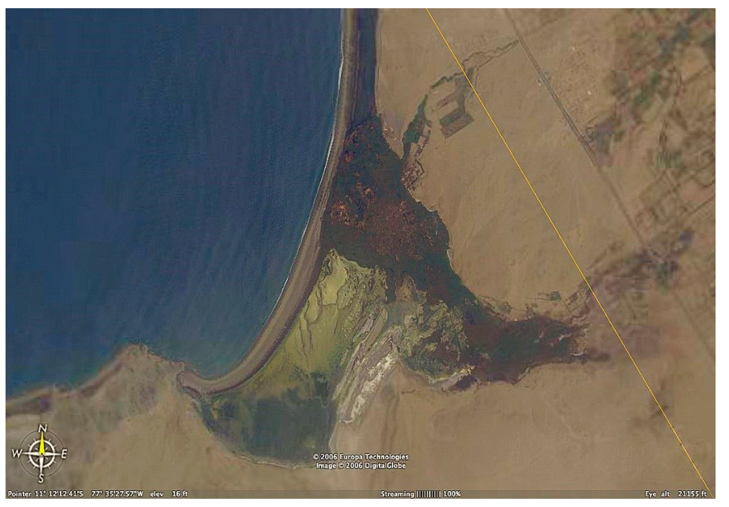
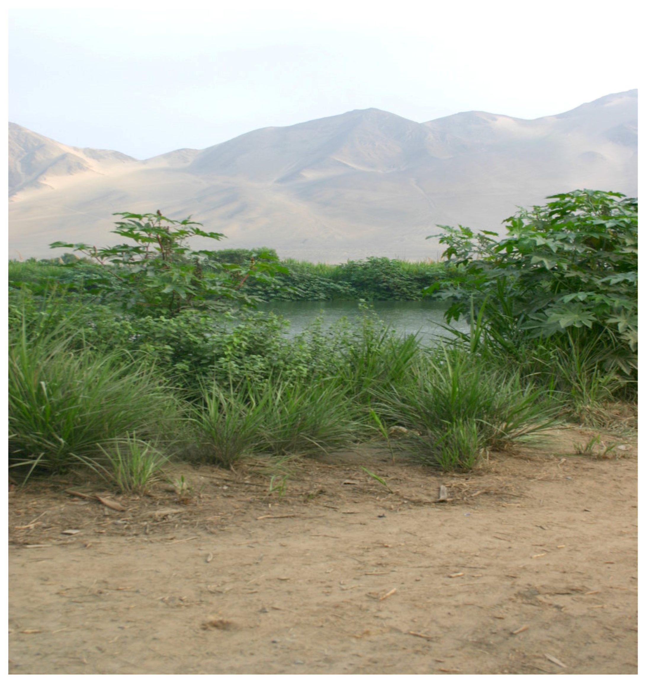
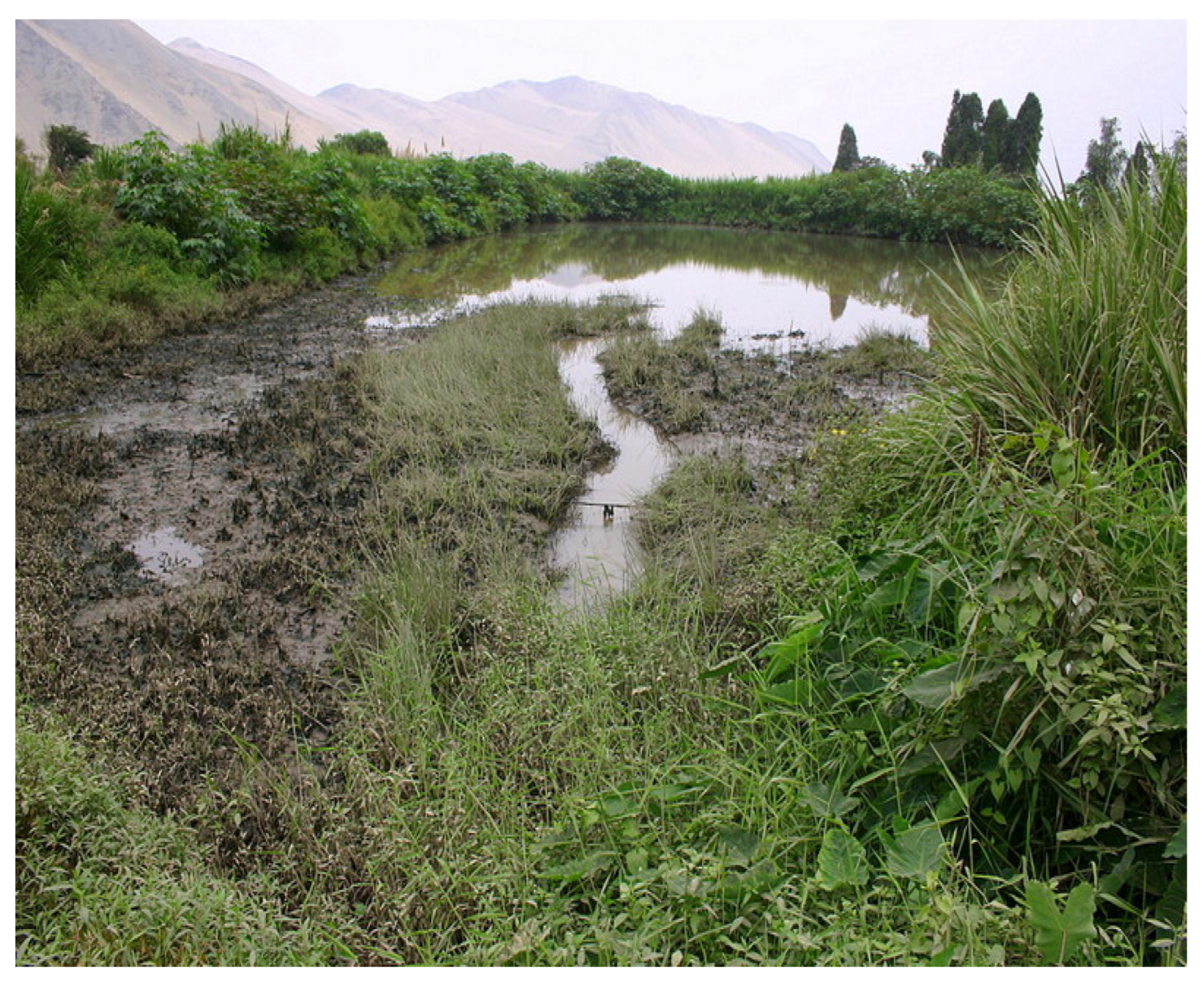
Figure 27 is a Google satellite view of the present Supe Valley coastline, indicating a portion of the Medio Mundo beach ridge that created a marsh area from the Supe River blockage. The CFD model counterpart is Figure 24 that indicates a similar marsh area behind an established beach ridge.
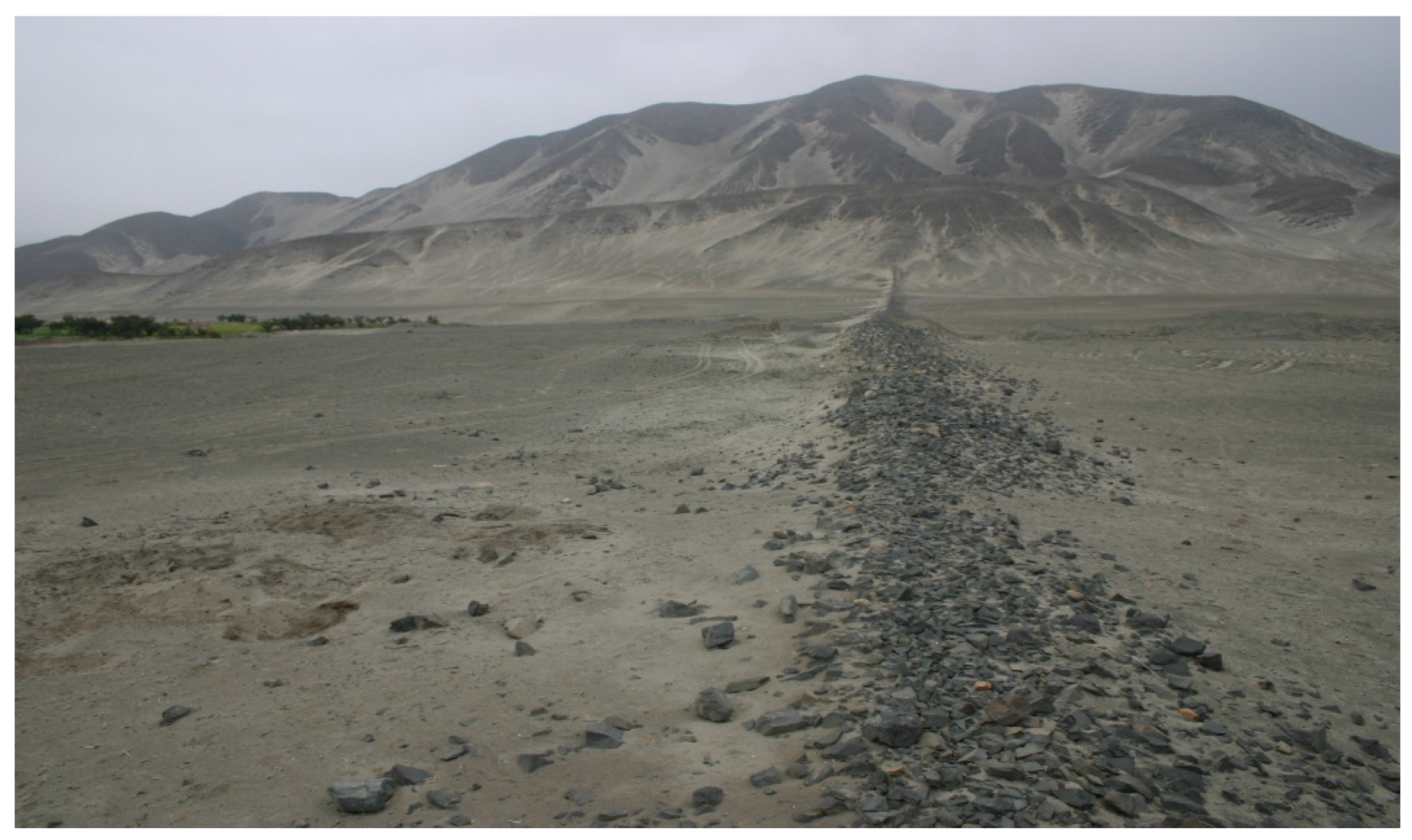
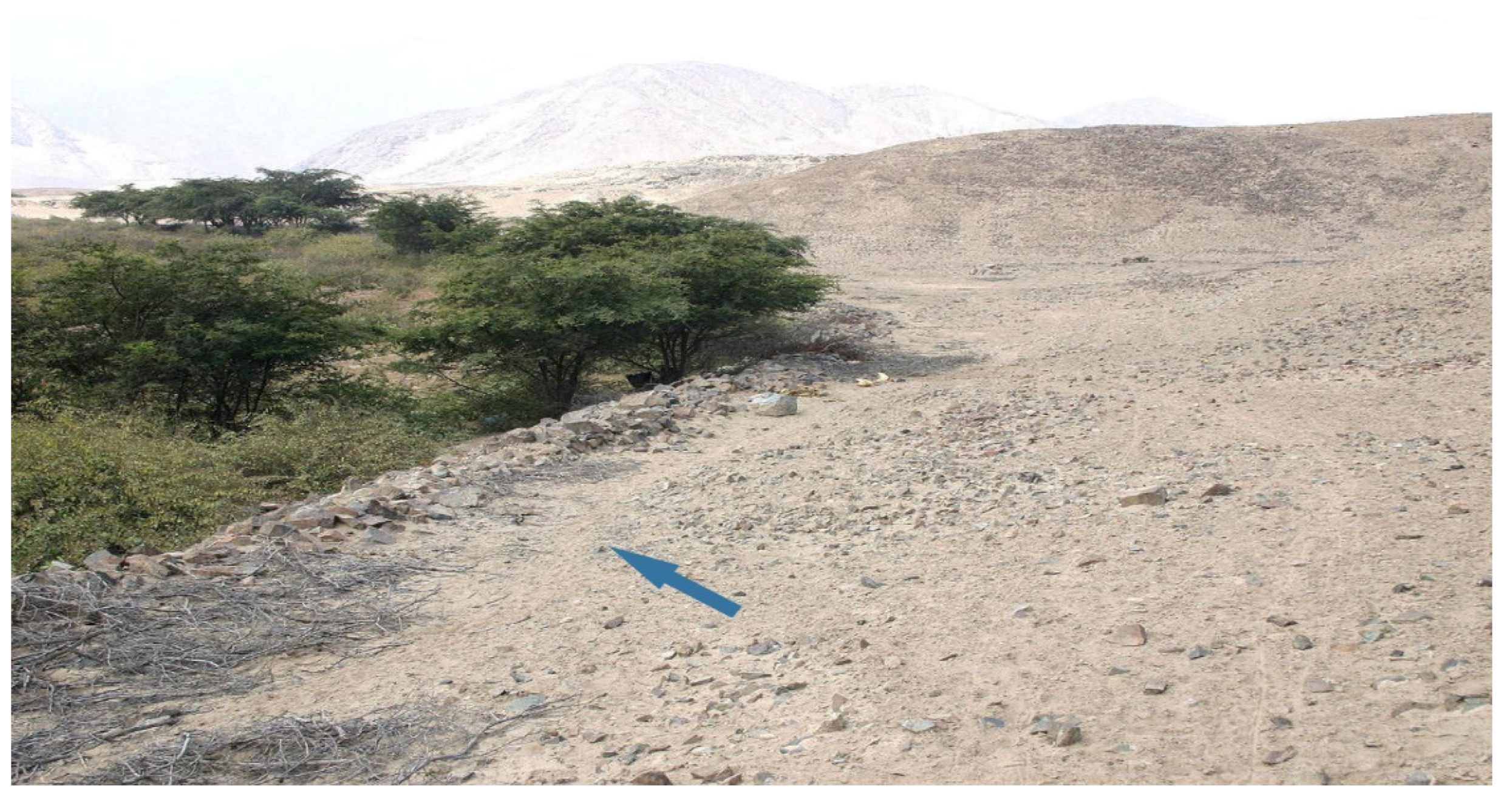
The 
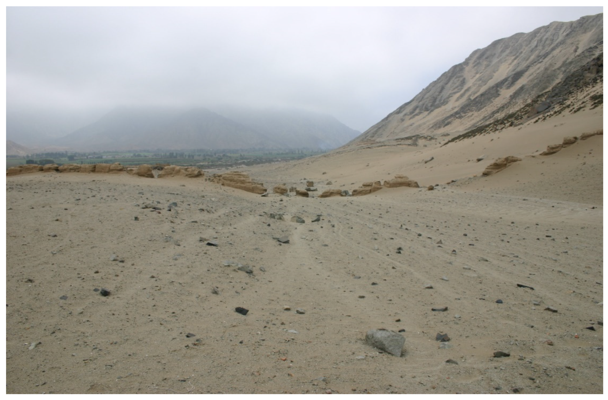
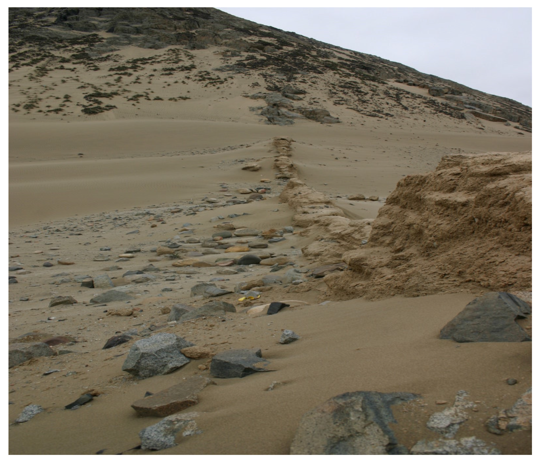
Figure 26 CFD result represents a case in which an existing offshore submerged sediment ridge allows sediment infilling of a previously existing bay area from a flood event. For this case, the previously existing marine resource base consisting of shellfish and sardine and anchovy net gathering no longer exists, forcing fish gathering at greater offshore distances to sustain the protein food-supply base. As this food-supply change takes time to develop an equal marine base resource to previous values, a major flood event has immediate consequences to sustain the large population of inland sites. Once the beach ridge deposits are in place, the accretion of sediment from later flood, river and aeolian sand transport events leads to the gradual infilling of the shoreline littoral. That the aeolian sand transfer from the southern Huara Valley was also a continual threat to Caral’s city environment was demonstrated by the multiple stone wall capture sand barriers constructed in open inland areas south of Caral (Figure 28, Figure 29 and Figure 30).
CFD-generated Figure 24 and Figure 26 detail the effects of a later flood event that superimposed sediment deposits upon a previously established subsea ridge with results specific to shallow seabed angles. Shown in Figure 25 are the fluid fraction results: f = 1.0 represents ocean water, f = 0.0 represents the sediment slurry stream and intermediate f values indicate slurry–ocean water mixture states. Sediment deposits on top of, and on each side of, the original subsea ridge provide the barrier mechanism for accretion of inland sand and flood deposits. A trace ridge accumulates seaward of the main sediment ridge and affects subsequent ridge development as the sea bottom geometry has been altered together with the river discharge outlet geometry. This result, when repeated for multiple flood events, qualitatively demonstrates how sand and flood sediment accumulates inland and behind (and to a lesser degree, in front of) a beach ridge by multiple flood, river, canal drainage, and aeolian sand/fines transport. Such changes in the seabed geometry from multiple ENSO events alter the composition of fish species available, as well as the availability of shellfish types that can only exist at certain water depths.
The current research [36] demonstrates the time change in marine-resource dietary patterns derived from beach ridge formations originating from ENSO events occurring over a long time period on the Peruvian shoreline. Here, the cumulative effect of ridge formations proceeding seaward on the seabed from sequential ENSO events gradually infills bays (Figure 24, Figure 26 and Figure 27) and creates a changed marine environment, accommodating different fish species and shellfish types over time. For a major ENSO event, such as that which occurred in the Supe Valley area in the Late Archaic Period, adaptation to a changed marine environment, coupled with induced changes in the valley agricultural environment from coastal zones to limited inland valley bottomlands, eventually led to limitation in the areas in which general agriculture products and certain agricultural varieties could be grown. As each coastal valley had different soil types and landscape geometries, it is expected that the effect of a major ENSO flood event would have different effects on different valleys and affect local sources of food supply.
The composition of beach ridges depends on the soil composition of individual valleys; due to the northward ocean current carrying of dilute slurry materials, beach ridges occasionally contain a mixture of flood sediments from adjacent southern valleys. In certain cases, beach ridges subject to current analysis ~4600 years after their formation may have continuity gaps, due to millennia of landscape erosion and deposition events.
When a mega El Niño flood simultaneously affects multiple river valleys with a steep offshore seabed slope, sediment fields coalesce to form a large unitary ridge spanning the coastline typical of the ~100 km long Medio Mundo ridge observed to span the littoral of five north central coast river valleys. A result of prograding processes behind ridge barriers results in the formation of brackish water lagoons and marshes, such as those observed at the Supe Valley river mouth that represent the physical reality of the CFD prediction. Figure 27 shows a Medio Mundo beach ridge segment and the marsh area that, prior to a major ENSO event, was a large part the agricultural area for the Archaic Period coastal site of Áspero [35], whose existence from ~3600 to 2400 BC is noted in Figure 2. After ~2400 BC, new interior Supe Valley sites proliferated, as additional highland rainfall supplied amuna water transfer to the Supe Valley served to elevate the groundwater level and permit extensive interior valley-bottom agriculture [3,35]. As ~1600 BC was the start of major ENSO events [19,37], as noted in Figure 2, it is likely that a major flood event (or sequence of events) negatively influenced nearby coastal agricultural field systems.
To date, the continuous extent of the Medio Mundo beach ridge is not available due to millennia of erosion/deposition events compromising sections of the beach ridge; given its relation to the demise of Preceramic Archaic Period sites in the 1600 BC time period due to a major El Nino event (or events), its approximate formation date is on the order of 1600 BC. However, a more reliable estimate of its formation date can be made by examining the broader history of beach ridges along the northern coast of Peru (Figure 6). The Medio Mundo beach ridge could not have been deposited prior to sea-level stabilization, so it is younger than ~6000 cal BP. Given the ridge-forming processes identified in the region, El Niño floods were active for Medio Mundo to form; this provides a maximum limiting date of 5800 cal BP. Furthermore, rains associated with El Niño events are attenuated to the south. Given these formation date limits, the northernmost dated beach ridge plain (Chira and Colán) began forming ridges earlier than the ridge plains further south. The available dates place the origin these ridges between about 5000 and 5200 cal BP [37,38]. To the south, the earliest Piura date is around 4100 cal BP, and the earliest Santa ridge date is around 4000 cal BP [37,38]. Following this trend, the Medio Mundo ridge should date between ~3900 and 3700 cal BP. This time span overlaps the latest dates for most of the north central coast Late Archaic centers and exists in a time frame necessary to influence the marine resource base of Norte Chico societies.
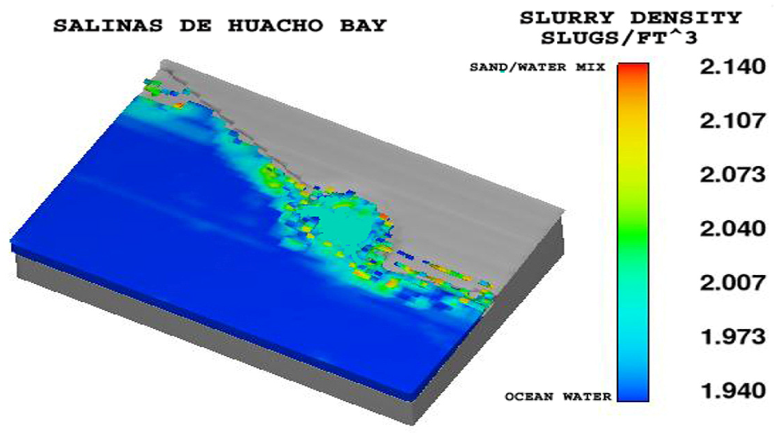
A further CFD result relates to the Salinas de Huacho area in which vast aeolian sand accumulation infilled bays. During El Niño events occurring in the southern reaches of the north central coast, flood sediment was mainly composed of sand transferred from the Chancay and adjacent southern rivers valleys; a calculation of sand-rich sediment emanating from the Chancay River (slurry density is approximately ~2.34 slugs/ft3 = 1206 kg/m3) indicates sand transfer to the Salinas de Huacho area ~25 km north of the Chancay River. Multiple flood events would continue the infilling processes to create the observed vast beach flat area. Again, individual velocity vector patterns, according to the geophysical values (Figure 23), prevail to create different types of near-shore deposits.
The C14 dates of shallow-water mollusks that lived 0.5–1.0 m below shoreline sands indicate the 4000–4500 BC shoreline was about 3 to 4 km from the present-day shoreline (Figure 8), indicating that large scale sediment accretion continuously altered both the marine and inland farming area resource bases through numerous flood and sand transfer processes, similar to what Figure 26 predicts. Similar shoreline and inland infilling processes behind the massive Medio Mundo ridge characterize the north central coastal valleys bounded by that ridge.
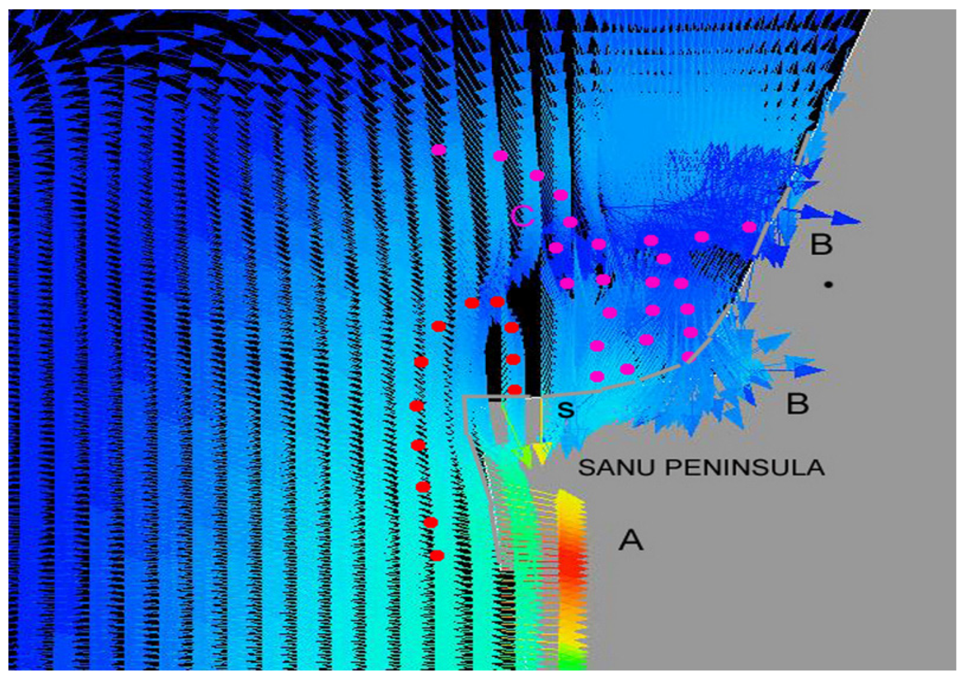
A further example illustrates the ridge-formation process in the presence of the irregular coastline of the Sanu Peninsula, which forms the southern boundary of the bay on which Bandurria and Áspero are located (Figure 1). The far offshore Peru Current velocity is ~4 cm/s, while the shoreline drift currents are ~3 to 7 cm/s but vary northward due to coastal geometry effects. Figure 31 indicates that the coastal current caused the shifting and deposit of sediment, creating a curvilinear bay ridge and an inland marsh area, as sediment drainage was blocked by the ridge (Figure 26).
Figure 31 shows the dot trajectories of light sediment particles from flood runoff entering the coastal current from southern reaches. Here the shape of a portion of the coastline has influence on the shape of its northward reaches due to the influence on the ocean current velocity distribution. The sediment trail loops around the (gray) Sanu promontory (near site 1 in Figure 1) to deposit sediments along the shoreline, adding to the expansion of the original pre-ENSO event shoreline area. The northward dot sequence shows vortical currents depositing sediment to form a further coastal shoreline extension. The CFD results indicate the qualitative nature of the prograding process; the quantitative determination involves detailed knowledge of the rainfall intensity and duration, geographic extent, event-time duration and the amount/type of surface material available for transport by the eroding action of floods. Sediment transport from the upper-valley areas from flood events, river and aeolian transport, as well as sand transport from southern valleys from ocean currents, accelerated coastal infilling both ahead of and behind the Medio Mundo beach ridge extending from the Huara to the Fortelaza Valley. Based on a survey of the lower Supe Valley, ~3 to 5 km of accreted sand, fines and clays deposited to a depth of 3 to 5 m over the Holocene beach littoral inland of the present shoreline since El Niño floods began at the time of sea-level stabilization. The sand seas in the Huara area, south of the Supe Valley, subject to strong onshore winds, sourced the aeolian transport of vast quantities of sand over the southernmost mountain chain that bounded the Supe Valley to inundate the inland valley farming areas. Sand accumulations appear on the north and south sides of the Supe Valley, as the small, intermittent discharge Supe River presented no barrier to across river valley aeolian sand transport. Buried sand layers covered over by later farming surfaces are present throughout the Supe Valley profiles (Figure 20), indicating continuous aeolian sand and flood sediment transfer events over millennia. As a consequence of the infilled bays and lagoon formation landward of the ridges, coastal lagoons dominated by reeds were created under brackish water conditions; this environment exists in lower valley plains landward of Áspero.

8. Changes in the Agricultural Landscape of the Supe Valley

Figure 23 and Figure 25 show the beach ridge formation from a single large-scale El Niño event to produce the Medio Mundo ridge. This large-scale event sealed off the bay at the Supe Valley and the shallower Albufero and Medio Mundo inlets and the Pariso bay below Huacho and to the South, created the Salinas de Huacho sand flats. To the north, bays and inlets through Bermejo were closed off [1]. With this ridge in place, northward ocean currents narrowed the width of the ridge in time and deposited material westward of the ridge to form new beach areas. In time, another El Niño event followed, with river-borne material cutting through the earlier ridge and depositing new material further westward of the earlier ridge on the beach deposited by the prior El Niño deposit. This process leads to sequentially spaced ridges propagating westward into the ocean; due to northwesterly winds carrying sand, the land between the ridges was gradually buried, leading to the beach ridge areas shown in Figure 17, Figure 18 and Figure 27. The sequences of ridges formed in this manner are clearly observed in the infilled Supe Bay, as well as in the Santa Valley areas among other nearby valleys. With exposed beach flats covered with aeolian sand, plus sand transport over the northern mountains of the Supe Valley, large sand dunes formed in the lower Supe Valley, limiting agricultural land areas. The high water table in the Supe Valley with moist soils provides for increased erosion transport during El Niño flood events, further reducing valley-bottom arable land; this, in combination with sand incursion and a loss of marine resources because of a sequence of major El Niño events, clearly limited Caral’s survival. Limited agriculture on the plateau adjacent to Caral (Figure 19) provided the only option left to sustain the small population left in Caral post the ~1600 BC time period.

9. Groundwater Amplification Processes Affecting Supe Valley Agriculture

The limitations to the groundwater drainage due to hydraulic conductivity resistance from accreted sediment and clays behind beach ridges affected areas and led to the gradual elevation of the up-valley groundwater profile, causing numerous springs and water pools to appear in the upper reaches of the Supe Valley (Figure 9, Figure 10 and Figure 11). Since the lower valley near the coastal delta areas originally comprised most of the agricultural lands, farming land loss and reduced soil fertility due to sand accumulation overlays and deposited flood sediments consisting of eroded sierra gravels and stones, gradually led to agriculture being transferred further inland to narrow bottomland and plateau locations nearer to Caral (Figure 4). This transition was further reinforced by flood events that compromised coastal farming areas. In the near-coastal areas, sediment buildup caused the water table to appear lower with respect to the ground surface limiting spring formation; in the mid-valley locations, the water-table height increased due to near-shoreline clay deposits increasing the aquifer-flow resistance as well as a subterranean geological ‘choke’ contraction on the Supe River that elevated the local upvalley water table height. To provide surface water to coastal field systems, river or spring flows would have to be channeled from far upriver locations to achieve elevation over coastal plains; no such channels are apparent on valley mountainside margins, indicating the abandonment of coastal agricultural zones. The rough mountain corridor topography incised by erosion gullies and sand deposits covering Supe Valley margins prevented long canals originating from valley neck areas to be extended along valley sidewalls to provide water to lower elevation lands. The reconnaissance of the southern Supe Valley mountain corridor areas yielded no trace of long, high-elevation canals.
As a result of flood sediment accretion over the coastal farming zones and sediment infilling of coastal zones behind the coastal beach ridges forming the Medio Mundo ridge, only narrow, mid-valley bottomland farming areas irrigated by spring-sourced, short canals and amuna water supplies remained to replace extensive coastal-zone agricultural areas. As coastal rainfall is on the order of a few centimeters per year, producing an intermittent Supe River flow, springs resulting from inland groundwater elevation and sierra amuna sources (lakes and reservoirs) supported valley agriculture throughout the year, albeit in narrow inland valley bottom areas. As testament to the high volume of groundwater underlying the Supe Valley, a current drainage channel adjacent to the access road to Caral from the Pan-American Highway flows continuously throughout the year, with a high velocity drainage flow indicating that water abundance, rather than shortage, to support multi-cropping throughout the year in the present, as in the past. This drainage channel, presumed to have an ancient counterpart, was vital to drain fields of excess irrigation water; this, in turn, limited the salt deposits in agricultural fields that, over time, would limit field system productivity.
A survey of the Supe River choke point revealed Canal A with a river inlet (Figure 1, Figure 14 and Figure 15) to support the ramped canal to Chuapacigarro. Due to the riverbed meander and braiding characteristics of low-slope rivers, rainy season canalized flow to valley bottomland farm areas proved unreliable as the river channel frequently deviated from the established canal inlets. As springs developed in the valley bottomland areas distant from the coastline from amuna-based groundwater elevation as shoreline prograding progressed, the changeover to spring-supplied canals provided reliable, year-round irrigation systems that additionally maintained the high-valley groundwater level.
The long, low slope, ramped canal (whose entrance and path is now obscured by dense plant growth (Figure 12 and Figure 13)) supported the spring-sourced Canal A–C (Figure 15) to provide water to the plateau field areas. The embankment ramped canal brought water to Caral and Chupacigarro and was the remedy to add plateau agricultural land areas to supplement the limited narrow inland bottomland areas subject to flood erosion and/or coverage by flood sediment. As an anecdotal note, one local farmer employing valley bottomland for agriculture reported that, as a result of the 1989 El Niño event, 50 hectares of his farmland were washed away; this observation also held true in ancient times, so that devastating floods reduced valley bottomland agriculture irreversibly requiring new lands to be developed on the Caral plateau (Figure 15) to avoid land loss. In the Supe Valley, the excavation house indicates that a canal provided water integral to Caral city precincts, although its path remains unexcavated and is no longer available due to landscape erosion. Canals E, G and C served the site of Chupacigarro, canal D serves modern field systems and an early Canal B–C (Figure 1) provided irrigation water from a spring at the origin point of the ramped embankment canal.

10. Sand Incursions Affecting the Supe Valley Agricultural Base

With the formation of the Medio Mundo beach ridge in the ~1600 BC time frame, sand flats and marsh areas formed near the Supe Valley river mouth near the modern shoreline. Figure 32 illustrates the aeolian sand transport from the southern Huara Valley south of the Supe Valley originating from northwesterly winds. Sand accumulations exist from the archaic times to the present day (Figure 7) in the Supe Valley margins that compromise agricultural soil fertility and, in Late Archaic period, required sand barriers (Figure 27, Figure 28 and Figure 29) to limit sand incursion into the site of Caral proper. The sand incursion extended to swamp areas behind the Medio Mundo beach ridge and compromised formerly productive coastal agricultural lands in the Late Archaic Period, as well as in the present day.
Figure 32 summarizes the following processes: localized El Niño flood drainage paths (1) combined with river fluvial sediment from Fortelaza, Patavilca, Supe and Huara rivers delivered sediment to coastal areas; (2) flood sediment coalesced into an existing segment of the Medio Mundo beach ridge with ridge geometry determined by sequential sediment transport amounts and the oceanic/drift current magnitude; and (3) sand areas trapped behind the Medio Mundo ridge subject to onshore winds further compromised inland agricultural land areas through inland dune transport. Remnant sand accumulations on the Supe Valley northern side limited river flow, reducing the agricultural potential of the coastal delta area. Increased hydraulic resistance to groundwater drainage from sediment deposits and clay formation in saturated coastal soils backed up the groundwater height and led to increased numbers of springs appearing in the valley bottom areas inland from the coast. This effect was amplified by the northside mountains close to the Supe River exit region that choked the groundwater passage; this subterranean contraction effect required a groundwater height change to provide the hydrostatic pressure necessary to increase the groundwater flow velocity through the choke-point region.
Aeolian sand transport over the low mountains between the Huara and Supe Valleys resulted in burying lower valley agricultural fields with overlays of sand, as shown in Figure 7 and Figure 32; additional aeolian sand transport to the urban center of Caral was countered by sand barriers (Figure 28, Figure 29 and Figure 30) sequentially placed in the southeast canyon open area between the mountain areas. Figure 4 shows the limited extent of the Supe Valley inland bottomlands and the still-existing marsh areas at the Supe Valley mouth bounded by the still-existing Medio Mundo ridge. As sand inundation is constant and compromises soil fertility, modern farmers are forced to use fertilizer additives to sustain maize crops. Figure 15 indicates that a small part of the lower Supe Valley, nowadays has been restored for use; this was achieved as clay deposits near the river mouth region have increased aquifer flow resistance causing a groundwater height amplification that can sustain certain marginal crop types with less water needs not requiring irrigation canal networks in the near coastal bottomlands.
Further east of the valley, amuna water supplies and canalized reservoirs (Figure 11) to mid-valley farm areas (Figure 12 and Figure 15) now mainly support maize crops for the very limited population that currently exists in the valley. The aeolian sand-transfer process continues to the present day, and it is surmised that, in the Late Archaic times, sand incursion episodes were major and extended up to the site of Caral, compromising agricultural fields far down the river to the coast. This conclusion is supported by a ~3 cm sand incursion layer deposited atop the final archaic occupational flood sediment deposits in many test pit areas of the site, as illustrated by Figure 20.
In certain Supe Valley areas, the sand layer is stratigraphically overlaid by early ceramic bearing middens dating to the Initial Period (1600–800 BC), indicating some minor reoccupation of the Supe Valley sites, other than Caral proper in the valley in which limited agriculture could exist. Excavation pits reveal that this sand layer is now largely overlain by soil deposits from extensive modern-day farming. Eventually, the Rio Supe carved a stable path to the sea and localized agriculture was returned to near-river margins, in the present day, but both sides of the valley still show remains of the early inundation of archaic sand seas. As sand inundation in the post-Medio Mundo epoch compromised valley agricultural lands and further compromised the marine resource base, an argument for the demise of the Supe Valley society may be proposed at a time close to the creation of the Medio Mundo beach ridge in the Late Archaic Period.

11. Conclusions

Based upon the estimated formation date of the Medio Mundo ridge, a major El Niño event (or sequence of events) started a progression of geophysical landscape changes that compromised both the Supe Valley near coastal agricultural field systems and the coastal marine resource base through flood sediment infilling. Additionally, the flood erosion of thin valley bottomland saturated topsoil led to the reduction in available productive farm areas. ENSO flood and sand incursion into wide expanses of lower-valley bottomlands led to the abandonment of near-coastal agricultural lands and the use of narrow upper-valley land areas that limited agricultural production to lower levels beyond that necessary to maintain high population levels. Further flood events in the ~1800 BC period led to agriculture being moved to small terrace areas (Figure 15) close to urban Caral, which limited the food supply for the growing population of the Supe Valley. This climate crisis also affected other nearby preceramic sites (Figure 2). The effects of the Medio Mundo beach ridge barrier and subsequent closely spaced in time flood events (Figure 6) reduced the agricultural and marine resource base to the extent that large valley populations dependent upon the pre-existing food resource base experienced a collapse of the coastal–inland trade network established during earlier periods in which major flood events were not occurring to any degree. Based upon the decline of food resources related to ENSO events, Supe Valley sites underwent abandonment, as Figure 2 indicates. Figure 6 confirms the frequency of major flood and beach ridge events in the ~1600 BC time period to support the reduction in the agricultural and marine resource base. As further research may show, the large number of sites in the upper Supe Valley region (Figure 4) may have been an attempt to redistribute the valley population around transitory functioning land and water sources, as water and farmland availability for agriculture rapidly decreased in the lower bottomlands part of the valley over a short time period. Although rainfall continued to charge sierra basins during El Niño events, the amuna source of water to the Supe Valley bottomlands only made matters worse by contributing additional flood water over highly saturated farmland soils. Estimates of the maximum Caral population size [8,10,13] are on the order of several thousand, based upon the number and the extent of excavated housing areas; the reduction in food supplies from increasingly smaller agricultural areas, together with a reduction in the marine resource base, then made life untenable past ~1600 BC.
Ancient (and modern) civilizations of Peru experienced recurrent ENSO episodic climate change patterns inducing floods, drought and landscape change through inflation and deflation cycles that affected their cities and agricultural base. Despite these challenges, several of these societies demonstrated continuity throughout time by relocating their population to areas with more land and water resources and/or instituting large-scale inter- and intravalley water-transfer projects [43,44]. While such changes provided a form of societal continuity for several societies, other societies vanished from the archaeological record when their agricultural systems did not respond or permit modification to use alternate water sources for their agricultural fields. While some societies managed to overcome environmental challenges by technological innovations applied to modify agricultural landscapes to maintain food productivity, other Andean societies unable to implement successful modifications, due to the irreversible damage to agricultural and marine resource areas, and unable to return to their current resource base, terminated their existence from the archaeological record [22,27,43,44,45]. For Late Archaic Period Norte Chico societies, landscape changes induced by the establishment of large beach ridges from a major ENSO flood event severely altered the agricultural and marine resource base, to the extent that the intra-valley trade network no longer functioned. As food resources diminished from reduced farming areas and decreased marine resource availability, changes in social structure to accommodate a population out of balance with the available food supply was a likely source of population decline or resettlement to other life-sustaining areas, although further details of this transformation of Caral society structure is now only in its early stages of research.
El Niño flood deposition events formed subsea ridges that initiated progradation processes infilling coastal zones trapped by the ridges. A comparison of the duration dates of preceramic coastal societies (Figure 1) to beach ridge dates (Figure 2) indicates an overlap period accompanied by intense El Niño activity. By ~1800 BC, most local sites were depopulated (Figure 2), indicating a common cause for the abandonment of the central north coast area. The effects of the gradual loss of the marine and agricultural base of north central coast societies were likely contributing factors to the abandonment of these major sites (Figure 2). Evidence of flood events from depositional silt layers and later marsh formation in the regions west of Áspero [34] verify major flood-event consequences in the Late Archaic Period. Within the Supe Valley, excavation profiles reveal sedimentary layers dispersed with sand layers indicative of major erosion and deposition events from ENSO events. Recent research [36] in the Norte Chico region related to subsistence changes in the Preceramic and Initial Periods indicates that the presence of littoral changes brought about by ENSO events caused a shift in the dietary composition of site inhabitants. Bay infilling in the Huaca Negra area (close to the present-day town of Barranca) was apparently slower, due to different landscape and valley geophysical conditions than in bay areas to the north, permitting longer-term shellfish gathering in shallow-bay areas, as well as a shift in netting small schooling fish to catching fish species found in deeper offshore waters. The gradual changes in the landscape and offshore bed geometry particular to different coastal valleys from sequential ENSO events permit, in certain cases, continued, but limited, availability of a modified food resource base sufficient to reinstitute previous food supply norms. Only when such transformations are possible, can societal continuance occur, but, in a limited condition, compared to previous norms.
Since the inland valley bottomlands and sierra foothill areas at the western edge of the Cordillera Blanca Andes were the source of most springs and water basins that penetrated the groundwater level (Figure 9, Figure 10 and Figure 11), agriculture was limited to up-valley narrow bottomlands and limited ramped canal plateau areas (Figure 19) as a result of the geophysical landscape changes and aeolian sand incursion from exposed beach flats. As marine resource extraction was the purview of coastal communities and inland sites that supported farming, reciprocal product trade diminished between inland and coastal communities as a result of a major ENSO event (or series of events) that altered previous trade-basis norms.
To sustain large-scale agriculture in the gradually infilling coastal environment, river or spring water would have to be channeled onto land surfaces lower than the riverbed choke point; this would require canal inlets originating far upriver to achieve elevation over the near-coastal land surface and canal construction on the steep and erosion-incised mountainside corridor topography on the upper reaches of the Supe Valley to revitalize lower-valley agricultural lands.
Sand accumulation on mountain slopes limited ambitions for canal extension to lower-valley areas. Extensive surveys of the southern mountain corridor flanks of the Supe Valley revealed no high-level canal construction. Thus, the coastal area was progressively removed from agricultural exploitation and could not be irrigated by canalized river sources. Since coastal areas decreased in agricultural productivity over time from erosion of topsoil, overlays of flood sediments and aeolian sand deposition, transfer of agriculture to narrow valley-bottom farming areas in inland valley locations could not support a large population. The disruption of the marine resource base from bay infilling and sediment deposits over mollusk shell beds accompanied the loss of farmlands and the viability of the economic model upon which Supe Valley society was based. A later Formative/Initial Period occupation occurred at some valley sites with limited construction overlay over earlier temple sites; the sand layers between the construction phases attest to large sand incursions during the hiatus period.
The results presented relate to the investigations conducted in the Supe Valley and reconnaissance of the coastal areas of the adjacent Fortaleza, Patavilca and Huara valleys. These valleys contain Late Archaic Period sites and yield terminal C14 dates for these sites consistent with those sites in the Supe Valley [30,31,41]. The present analysis extends investigations [34] detailing reasons for the collapse of the agricultural and marine resource base of the Supe Valley society in the Late Archaic Period from the geomorphic changes described to date and are causative elements contributing to societal disruption from previously established societal norms established over long time periods with stable environmental conditions.
Several climate-driven events that altered the ecological conditions beyond recovery have influenced Andean prehistory. Notable is the collapse/transformation of the southern Moche V society in the 6–7th Century AD by cycles of high rainfall, severe drought and sand incursion into their Moche–Chicama Valley homeland [1]; the collapse of the altiplano Tiwanaku society in the 12th Century AD due to extended drought [37,43,44]; the collapse of the Lambeyeque Valley Sican and Wari societies in the 12th Century AD due to extended drought; the collapse of the Chimú intravalley (Moche Valley) canal systems in the 11th Century AD [43] and El Niño flood catastrophes experienced by the Chirabaya [45] in far-south Peru. To this list, Caral is a further example based on the rapid decline in the agricultural and marine resource base, which exerted a profound influence on the continuance of the economic model of Supe Valley sites. Given the abandonment of major Late Archaic sites in ~1800 BC in nearby valleys, the environmental change based upon the formation of the Medio Mundo beach ridge was likely a key event for the similar fate experienced by the Supe Valley societies.

12. Further Text Notes

  • Evidence of the ENSO events: Refs. [5,6,7,37]; Figure 6 shows the sequence of events in the Medio Mundo date range over the extensive length of the Peruvian coastline.
  • Bay infilling results: Figure 27 shows a satellite view of the infilled bay at the mouth of Supe Valley due to the beach ridge blockage of river drainage paths creating a marsh area.
  • Farming of the Supe Valley bottom areas: as later phases of coastal Áspero were contemporary with early phases of Caral origination in 4600 BC, early agriculture was located close to the Supe River coastline, close to Áspero, with its high water table and flood transferred fertile sierra soils. The land area was extensive, prior to a Medio Mundo ENSO flood event that transformed the land area into the later marsh area location.
Mid-valley Caral amuna water systems for agriculture then provided a safer mid-valley location for Caral and subsidiary sites, given its amuna water supply that could accommodate substantial population increases. As later ENSO events created sediment blockage of previous coastal farming areas and marsh creation, mid-valley agriculture with mainly amuna water supplies and reservoir-based (Figure 9, Figure 10 and Figure 11) canal systems permitted agricultural expansion to support the population increase.
  • Contemporary ENSO events and unsuitability for agriculture: Santa-Viru coastal area flood events were contemporary with Forteleza–Huara coastal area flood events caused by a major Medio Mundo event (or closely timed series of events); the destruction of mid-valley agricultural soils from flood-amplified, valley bottomland erosion further amplified by amuna supplied saturated soli thin farming layer erosion, together with the fact that the Supe River runs over relatively flat land causing the Supe River to meander under a flood event and overspill its banks and erode river-side farming areas, indicates that Caral food supply sustainability was continually challenged by flood events in early phases of its development.
  • Drainage channels: these are seen in modern times alongside the entry road to Caral; due to the amuna supplied high water-table amplification, drainage channels were the only means to regulate local water-table height for specific crop types, both in ancient and present times. Since ancient mid-valley agricultural systems were likely in form similar to what exists today, it is likely that a similar drainage system was in use in ancient times.
  • Level of groundwater post-flood and duration: Supe Valley groundwater remains within a meter of the farming surface due to the continuous amuna water supply that continues from ancient times to the present day. The Supe Valley is unique compared to most other Peruvian valleys as it has too much water and needs a drainage network to control the water-table height for agriculture. Later ENSO events threatened agricultural sustainability as flood water easily washed away thin saturated farming topsoil, given the current-event example described in the manuscript.
  • Abandonment of the valley bottom: Figure 15 indicates the valley-bottom story; initially, agriculture in the early Late Archaic Period was close to the Supe Valley coastline area in which sediments over large river-mouth areas had fertile farm soils washed down from mountain areas. Later, as flood events became more common, flood events and beach ridges created marsh areas in which farmland once existed; as mid-valley near-river farm areas were the next alternative after coast area abandonment, these areas were, in time, also compromised as saturated amuna thin soil layers were easily washed away from floods. What remained, as Figure 15 shows, was that agriculture was moved to the upper plateau area on which Caral was located, along with far up-valley sites where Supe River water could be used for local, but smaller, agricultural fields. There were long stretches of time between destructive events on agricultural systems, where mid-valley agriculture could be successively used between major El Niño flood events. Presently, Figure 12 (photo taken about 30 years ago) shows the current status of mid-valley agriculture, where amuna water still supplies the high groundwater now mainly used for maize crops; the earlier 1959 El Niño event compromised existing near-river lands and, after several years, with a new soil layer deposited from mountain soil deposition and commercially added fertilizers, lands were used, once again, to continue agriculture.
  • Productivity of areas: Supe valley crop types used in Late Archaic times are described in the text; the variety of inner-valley crops (plus extensive cotton-planting areas) provided reciprocal export trade comestibles to coastal areas for their fish and shellfish exports. The productivity and fertility of crop types was likely enhanced by plowing under leaf material for their mineral content; this decomposition fertility increase was aided by the high moisture level of mid-valley farming soils. There were valley areas of different heights that provided different groundwater moisture levels for different crop types; for example, cotton growth requires constant water availability, so cotton plants would be situated on lower-height land areas where the groundwater height was closer to the land surface. Other crops would accordingly be assigned to land areas in which the moisture level was appropriate for their growth.
  • Population supportable with agriculture before and after Enso events: initially, at the early phases of the Late Archaic Period with the limited Supe Valley population, Caral and near-coastal sites were in the preliminary stages of development using near-coastal valley delta agricultural lands. Population levels were likely on the order of hundreds and likely drawn from local valley tribal groups realizing the agricultural potential of the Supe Valley from its water abundance. Later, as ENSO events originated and intensified, coastal lands, once fertile sources of agriculture and marine resources, diminished in productivity leading to mid-valley agricultural land development; this proved a positive move, as population growth could then be continually supported from the high water-table amuna water supply for multi-cropping of a wide variety of crops. Population levels were in the low thousands after this relocation which likely promoted additional valley sites (Figure 4) and provided the labor source for new pyramid constructions (Figure 5). As ENSO events progressed and intensified, agricultural lands and marine resources were compromised in later time stages leading to site abandonment of most Supe Valley sites as Figure 2 indicates. This led to the collapse of inland to coastal trade, as food resources diminished to non-survivorship levels.
  • From field reconnaissance visits starting from approximately 20 plus years ago to a recent revisit in 2010, notable landscape features were apparent: linear beach ridge formations and coastal landscape changes from recent ENSO activity (Figure 17 and Figure 18). In order to determine their origins and given that their features derived from the fluid mechanics of El Niño flood events, recourse to CFD methods were initiated to show how these feature could originate. The manuscript’s many computer results (Figure 21, Figure 22, Figure 23, Figure 24, Figure 25 and Figure 26) now demonstrate the feature origins and help remove conjecture and speculation as to their origins. To date, the CFD results prove how beach ridges form linear shapes and how landscape change originated from El Niño flood events conclusively.

Funding

All finding provided by author.

Institutional Review Board Statement

Not applicable.

Informed Consent Statement

Informed consent was obtained from all subjects involved in this study given in the Acknowledgement section to follow.

Data Availability Statement

All data provided by author.

Acknowledgments

The author wishes to acknowledge the contributions of his colleagues Michael Moseley, Daniel Sandweiss, Donald Keefer and especially Ruth Shady-Solis, the official director of Caral excavations during five years of fieldwork at Caral. All the above-individuals cited contributed their specialist knowledge and research findings to this manuscript.

Conflicts of Interest

The authors declare no conflict of interest.

Appendix A. Supe Valley Site Names

(1) Bandurria; (2) Vichama; (3) Aspero; (4) Upaca; (5) Pampa San Jose; (6) Caballete; (7) Vinto Alto; (8) Haricanga; (9) Galivantes; (10) Culebras; (11) Las Aldas; (12) La Galgada; (13) Caral; (14) Rio Seco; (15) Las Shicras; (16) Kotosh; (17) Huarico; and (18) Piruru. The Allpacota site (Figure 15) lies between sites (8) and (9).

References

  1. Moseley, M.E.; Wagner, D.; Richardson, J.B., III. Space Shuttle Imagery of a Recent Catastrophic Change along the Arid Andean Coast. In Paleoshorelines and Prehistory: An Investigation of Method; Johnson, L., Stright, M., Eds.; CRC Press: Boca Raton, FL, USA, 1992. [Google Scholar]
  2. Knighton, D. Fluvial Forms and Processes: A New Perspective; Hodder Education, Part of Hachette Livre: London, UK, 1998. [Google Scholar]
  3. Rogers, S.; Sandweiss, D.; Maasch, K.; Belknap, D.F.; Agouris, P. Coastal Change and Beach Ridges along the Northwest Coast of Peru: Image and GIS Analysis of the Chira, Piura and Colán Beach Ridge Plains. J. Coast. Res. 2004, 20, 1102–1125. [Google Scholar] [CrossRef]
  4. Sandweiss, D. The Beach Ridges at Santa, Peru: El Niño, Uplift and Prehistory. Geoarchaeology 1986, 1, 17–28. [Google Scholar] [CrossRef]
  5. Sandweiss, D.; Richardson, J.; Reitz, E.; Rollin, H.; Maasch, K. Geoarchaeological Evidence from Peru for a 5000 BP Onset of El Niño. Science 1996, 273, 1531–1533. [Google Scholar] [CrossRef]
  6. Wells, L. Holocene Landscape Change on the Santa Delta, Peru: Impact on Archaeological Site Distributions. Holocene 1992, 2, 193–204. [Google Scholar] [CrossRef]
  7. Wells, L. The Santa Beach Ridge Complex: Sea Level and Progradational History of an Open Gravel Coast in Central Peru. J. Coast. Res. 1996, 12, 1–17. [Google Scholar]
  8. Shady, R. Sustento Socioeconómico del Estado Pristino de Supe-Peru: Las Evidencia de Caral-Supe. Arqueol. Y Soc. 2000, 13, 49–66. [Google Scholar] [CrossRef]
  9. Shady, R.; Haas, J.; Creamer, W. Dating Caral, a Preceramic Site in the Supe Valley on the Central Coast of Peru. Science 2002, 292, 723–726. [Google Scholar]
  10. Shady, R.; Leyva, C. La Ciudad Sagrada de Caral- los Origines de la Civilización Andina y la Formación del Estado Pristina; Proyecto Especial Arqueológico Caral-Supe; Instituto National de Cultura Publicación: Lima, Peru, 2003. [Google Scholar]
  11. Shady, R.; Creamer, W.; Ruiz, A. Dating the Late Archaic Occupation of the Norte Chico Region of Peru. Nature 2004, 432, 1020–1023. [Google Scholar]
  12. Shady, R.; Quispe, E.; Novoa, P.; Machacuay, M. Vichama, Civilización Agropesquerade Végueta, Huara: La Ideologia de Nuestros Ancestros, 3800 Ãnos de Arte Mural; Servicios Graphicos JMD S.R.L.: Lima, Peru, 2014. [Google Scholar]
  13. Shady, R. La Ciudad Sagrada de Caral-Origines de la Civilización Andina; Museo de Archaeología; Universidad Nacional de San Marcos Publicaciónes: Lima, Peru, 2001. [Google Scholar]
  14. Shady, R. The Social and Cultural Values of Caral-Supe, the Oldest Civilization in Peru and America and Its Role in Integral and Sustainable Development; Proyecto Especial Arqueologico Caral-Supe, Instituto Nacional de Cultura Publicación: Lima, Peru, 2007; Volume 4, pp. 1–69. [Google Scholar]
  15. Shady, R. Caral-Supe: Y Su Entorno Natural y Social en Los Origenes de la Civilization. In Andean Civilization; Marcus, J., Williams, P., Eds.; Cotsen Institute of Archaeology 63: Los Angeles, CA, USA, 2009; pp. 99–117. [Google Scholar]
  16. Shady, R. Caral- La Ciudad del Fuego Sagrado; Interbank Publishers: Lima, Peru, 2004. [Google Scholar]
  17. Weiss, H. Beyond the Younger-Dryas: Collapse as an Adaptation of Abrupt Climate Change in Ancient West Asia and the Eastern Mediterranean. In Environmental Disaster and the Archaeology of Human Response; Bawden, G., Reycraft, R., Eds.; Maxwell Museum of Anthropology Paper No.7: Albuquerque, NM, USA, 2000; pp. 75–98. [Google Scholar]
  18. Sandweiss, D.; Quilter, J. El Ñino, Catastrophism and Cultur, 17e Change in Ancient America; Dumbarton Oaks Research Library and Collection: Washington, DC, USA, 2009. [Google Scholar]
  19. Sandweiss, D.; Maasch, K.; Burger, R.; Richardson, J.; Rollins, H.; Clement, A. Variation in Holocene El Niño Frequencies: Climate Records and Cultural Consequences in Ancient Peru. Geology 2001, 29, 603–606. [Google Scholar] [CrossRef]
  20. Flow Science FLOW-3D User Manual, V. 9.3; Flow Science, Inc.: Santa Fe, NM, USA, 2020.
  21. Moseley, M.E.; Willey, G.R. Áspero, Peru: A Reexamination of the Site and its Implications. Am. Antiq. 1973, 38, 452–468. [Google Scholar] [CrossRef]
  22. Renfrew, C. System Collapse as Social Transformation: Catastrophe and Anastrophe in Early State Societies. In Transformations- Mathematical Approaches to Culture Change; Renfrew, C., Cooke, K., Eds.; Academic Press: New York, NY, USA, 1979. [Google Scholar]
  23. Paulson, A. Environment and Empire: Climatic Factors in Prehistoric Andean Culture Change. World Archaeol. 1996, 8, 121–132. [Google Scholar] [CrossRef]
  24. Moore, J. Cultural Landscapes in the Ancient Andes; University Press of Florida: Gainesville, FL, USA, 2005. [Google Scholar]
  25. Manners, R.; Migilligan, F.; Goldstein, P. Floodplain Development, El Niño, and Cultural Consequences in a Hyperarid Andean Environment. Ann. Assoc. Am. Geogr. 2003, 97, 229–249. [Google Scholar] [CrossRef]
  26. Contreras, D. Landscape and Environment: Insights from the Prehispanic Central Andes. J. Archaeol. Res. 2000, 18, 241–288. [Google Scholar] [CrossRef]
  27. Bawden, G.; Reycraft, R. Exploration of Punctuated Equilibrium and Culture Change in the Archaeology of Andean Ethnogenesis (Chapter 12). In Andean Civilization; Marcus, J., Williams, P.R., Eds.; UCLA Cotsen Institute of Archaeology Press: Los Angeles, CA, USA, 2009; pp. 195–210. [Google Scholar]
  28. Bawden, G.; Reycraft, R.M. Environmental Disaster and the Archaeology of Human Response; Maxwell Museum of Anthropology Papers No.7, University of New Mexico Press: Albuquerque, NM, USA, 2000. [Google Scholar]
  29. Lanning, E. Peru before the Inkas; Prentice Hall Publishers: Englewood Cliffs, NJ, USA, 1967. [Google Scholar]
  30. Haas, J.; Creamer, W. Cultural Transformations in the Central Andes in the Late Archaic. In Andean Archaeology; Silverman, H., Ed.; Blackwell Publishers: London, UK, 2004. [Google Scholar]
  31. Shady, R.; Kleihege, C. Caral, La Primera Civilización de América; Universidad de San Martin de Porres Publicaciónes: Lima, Peru, 2008; pp. 112–167. [Google Scholar]
  32. Feldman, R. Preceramic Corporate Architecture: Evidence for Development of Non-Egalitarian Social Systems in Peru. In Early Ceremonial in the Andes; Donnan, C., Ed.; Dumbarton Oaks Publications: Washington, DC, USA, 1985; pp. 71–92. [Google Scholar]
  33. Creamer, W.; Ruiz, A. Archaeological Investigation of Late Archaic Sites (3000–1800 BC) in the Pativilca Valley, Peru; Fieldiana Anthropology 40; Field Museum of Chicago Publication: Chicago, IL, USA, 2007. [Google Scholar]
  34. Sandweiss, D.; Shady-Solis, R.; Moseley, M.E.; Keefer, D.; Ortloff, C.R. Environmental Change and Economic Development in Coastal Peru between 5,800 and 3,600 Years Ago. Proc. Natl. Acad. Sci. USA 2009, 106, 1359–1363. [Google Scholar] [CrossRef] [PubMed] [Green Version]
  35. Barrera, A. Bandurria; Servicios Gráficos Jackeline: Huara, Peru, 2008. [Google Scholar]
  36. Chen, P. Marine-Based Subsistence and its Social Implications in the Late Preceramic Initial Period: A Different Pattern from Huaca Negra, North Coast of Peru. In Proceedings of the 58th Institute of Andean Studies Conference, Berkeley, CA, USA, 5–6 January 2018. [Google Scholar]
  37. Ortleib, L.; Fournier, M.; Macharé, J. Beach Ridge Series in Northern Peru: Chronology, Correlation and Relationship with Major Holocene El Niño Events. Bull. Inst. Fr. Etudes Andin. 1993, 22, 121–212. [Google Scholar]
  38. Richardson, J. The Chira Beach Ridges, Sea Level Change, and the Origins of Maritime Economies on the Peruvian Coast. Ann. Carnegie Mus. 1983, 52, 265–275. [Google Scholar]
  39. Bain, A.; Bonnington, S. The Hydraulic Transport of Solids by Pipeline; Pergammon Press: New York, NY, USA, 1970. [Google Scholar]
  40. Pulgar Vidal, J. Geografía del Peru, Novena Edición; Editorial PEISA: Lima, Peru, 2012. [Google Scholar]
  41. Haas, J.; Creamer, W. Crucible of Andean Civilization: The Peruvian Coast from 3000 to 1800 BC. Curr. Anthropol. 2006, 47, 745–775. [Google Scholar] [CrossRef]
  42. Abulnagy, B. Slurry Systems Handbook 3(3); McGraw-Hill Publishers: New York, NY, USA, 2002; pp. 183–210. [Google Scholar]
  43. Ortloff, C.R.; Kolata, A.L. Climate and Collapse: Agro-ecological Perspectives on the Decline of the Tiwanaku State. J. Archaeol. Sci. 1993, 16, 513–535. [Google Scholar] [CrossRef]
  44. Ortloff, C.R. Water Engineering in the Ancient World: Archaeological and Climate Perspectives on Societies of Ancient South America, the Middle East and South-East Asia; Oxford University Press: Oxford, UK, 2010. [Google Scholar]
  45. Reycraft, R. Long-term Human Response to El Niño in South Coastal Peru circa A.D. 1400. In Environmental Disaster and the Archaeology of Human Response; Bawden, G., Reycraft, R., Eds.; Maxwell Museum of Anthropology and Archaeological Papers: Albuquerque, NM, USA, 2000; Volume 7, pp. 99–120. [Google Scholar]
Figure 1. Site map of the coastal Norte Chico river valleys of Peru; the numbers represent major Archaic Period sites. Site 4 is Caral within the Supe Valley. Site 3 is Áspero. The North direction is in the vertical direction. The Chancay to Santa Valley distance is ~400 km.
Water 14 01403 g001
Figure 2. Time duration of the major preceramic sites in the Supe Valley shown in Figure 4 and Appendix A.
Water 14 01403 g002
Figure 3. (A) Caral site map. Note the proposed internal site canal (red line) in the region between the upper north and lower south areas based upon the canal profile data taken next to the Caral excavation house in the Residential Area. (B) Continuation Excavated canal cross-section profiles taken at the leftmost red-line canal extension Residential Area shown in Figure 3A thought to exist between the upper and lower regions of Caral.
Water 14 01403 g003aWater 14 01403 g003b
Figure 4. Site locations in the Supe Valley along the Rio Supe (site names given in Appendix A). The site of Áspero is located on a coastal prominence west of Site 1. Length scale from Site 1 to site 18 is ~80 km.
Water 14 01403 g004
Figure 5. Caral Major Pyramid (Huaca Mejor)—location presented in Figure 3.
Water 14 01403 g005
Figure 6. Beach ridge date ranges and locations along the coast of Peru. Band height ranges represent date ±1σ values from the mean value; descending (blue) lines indicate beach ridges in a specific area and their dates. Color bands reflect different information sources.
Water 14 01403 g006
Figure 7. Aeolian sand deposits on the southern side of the Supe Valley produced from aeolian winds from the southern Huara Valley.
Water 14 01403 g007
Figure 8. Shoreline changes over time in the area south of the Supe Valley. The dates measured from marine mollusk analysis indicate the variability of the shoreline shape due to ENSO sediment deposition/scouring events over time. (Figure courtesy of Daniel Sandweiss, personal communication).
Water 14 01403 g008
Figure 9. Typical interior Supe Valley pool derived from low-valley areas intersecting the high water table.
Water 14 01403 g009
Figure 10. Typical interior Supe Valley pool derived from low-valley areas intersecting the high water table.
Water 14 01403 g010
Figure 11. Major reservoir interior to the Supe Valley derived from groundwater penetration into a low-lying area.
Water 14 01403 g011
Figure 12. Supe Valley bottomlands below the southern elevated plateau that situates Caral and other sites shown in Figure 3. The Supe River separates current northern and southern agricultural fields.
Water 14 01403 g012
Figure 13. The plateau edge above the steep embankment leading from valley bottomlands to the plateau. Along the embankment (now hidden by brush) is the Ramped Canal indicated in Figure 3, leading to the early Chupacigarro interior valley site indicated in Figure 15.
Water 14 01403 g013
Figure 14. Interior channel from upper reaches of the Supe River leading river water to valley bottom agricultural and reservoir areas.
Water 14 01403 g014
Figure 15. Path of the Ramped Canal to the Chupacigarro site. Current agricultural (brown and black) areas extend to both sides of the Supe River. Figure 14 and the current figure show the canal inlet (A) located in the far upstream reaches of the Supe River. The notation B denotes Early Formative Period sites; C and D canals supplied the early site of Chupacigarro located at (red) F. The E and G locations are modern in-use bottomland fields irrigated by high groundwater levels.
Water 14 01403 g015
Figure 16. Trace of the canal leading to the Chupacigarro site.
Water 14 01403 g016
Figure 17. A linear beach ridge deposit along the Peru coastline resulting from an El Niño flood event. Note the marsh region behind the ridge resulting from the ridge blocking rainfall, river amuna discharge. The origin of such deposition events in history (Figure 6) is detailed in the next section.
Water 14 01403 g017
Figure 18. A further early coastal ancient linear beach ridge, now partially covered by aeolian sand drifts; further stranded beach ridges are to be found closer to the shoreline resulting from later El Niño flood events. Ongoing tectonic uplift helps to strand and separate a sequence of beach ridges.
Water 14 01403 g018
Figure 19. Deposition silt layers at a coastal Supe Valley site resulting from sequential El Niño flood events.
Water 14 01403 g019
Figure 20. Interior Supe Valley silt and sand deposition layers from sequential El Niño flood events and aeolian sand transport.
Water 14 01403 g020
Figure 21. FLOW-3D CFD model of the Peruvian coastline from the Santa to Viru Rivers. The Benthic Zone is the Pacific Ocean; the arrows originating from the Santa and Viru River Valleys represent El Niño flood sediment transfer paths into the Pacific Ocean and offshore arrows denote the direction of the northward Peru Current and the shoreline drift current.
Water 14 01403 g021
Figure 22. Offshore deposit of sediments. The right hand scale represents sediment density in slugs/ft3 as described in the text; ocean water has the 1.94 slug/ft3 scale representation. Intermediate scale values represent the mixing of flood derived slurry with the ocean current.
Water 14 01403 g022
Figure 23. Velocity vector plot indicating turbulent flow at the Supe River outlet indicating the source of differential particle size sediment settling. Velocity scale is in ft/s; length scale is in km.
Water 14 01403 g023
Figure 24. CFD calculated sediment deposition history of a later El Niño flood event interacting with the sediment deposit from an earlier flood deposit event (offshore grey bar ridge area). Note the formation of a water-laden backfilled marsh area between the shoreline and the beach ridge.
Water 14 01403 g024
Figure 25. Flood slurry deposition: f = 1 is the ocean water, f = 0 is the flood slurry. Intermediate f values represent the slurry/ocean water mixture. Note the formation of a linear offshore beach ridge from the slurry deposition close to the shoreline as dependent on the ocean bottom slope. Length scale in km.
Water 14 01403 g025
Figure 26. Later El Niño flood events creating a deposition sediment area behind an established beach ridge; the infilling phenomenon infills bays and creates marsh areas behind previously established beach ridges as well as extensions of previous shorelines, as the Figure 26 CFD model demonstrates.
Water 14 01403 g026
Figure 27. Google Earth satellite photograph of a part of the Medio Mundo beach ridge and infilled marsh area behind the ridge in the Supe Valley coastal area that limits river flows to the ocean. A ridge of this magnitude results from a catastrophic El Niño event (or closely spaced events) and subsequently alters the deposition placement of subsequent El Niño-derived beach ridge placements in different sections of the Peru coastline.
Water 14 01403 g027
Figure 28. A further stone wall aeolian sand transfer barrier placed at the Ostra base camp to the north of the Santa Valley; such defenses were typical of preceramic societies in the north central coast.
Water 14 01403 g028
Figure 29. Further stone wall aeolian sand barrier closest to Caral city limits.
Water 14 01403 g029
Figure 30. Furthest stone wall aeolian sand barrier. The barrier sequence represents efforts to limit sand inundation into urban Caral.
Water 14 01403 g030
Figure 31. Dot trajectories of the sediment transport paths from the coastal valleys south of the Sanu Peninsula. North of the Sanu peninsula, extreme ocean turbulence and induced rotational flow in the upper concave shoreline region enhance particle settling, resulting in the shoreline shape modification.
Water 14 01403 g031
Figure 32. Aeolian sand deposit areas in the Huara valley south of the Supe Valley and urban Caral transferred by constant northeast winds (Google Earth satellite photograph).
Water 14 01403 g032
Publisher’s Note: MDPI stays neutral with regard to jurisdictional claims in published maps and institutional affiliations.

