Article

Hydrogeochemical Characteristics of Karst Areas: A Case Study of Dongzhuang Reservoir Area in Jinghe River

1
Yellow River Engineering Consulting Co., Ltd., Zhengzhou 450003, China
2
Key Laboratory of Water Management and Water Security for Yellow River Basin, Ministry of Water Resources (under construction), Zhengzhou 450003, China
*
Authors to whom correspondence should be addressed.
Water 2022, 14(24), 4111; https://doi.org/10.3390/w14244111
Submission received: 10 November 2022 / Revised: 4 December 2022 / Accepted: 5 December 2022 / Published: 16 December 2022
(This article belongs to the Special Issue Hydrogeology and Geochemistry of Karst Aquifers)

Abstract

:
Karst leakage is the key problem that restricts the construction of reservoir areas. In this article, the hydrogeochemical origin and hydraulic connection of the river water, pore water, fissure water, and karst water in Jinghe Dongzhuang Reservoir, which is located in a karst area, are analyzed to determine the possibility of karst leakage in the reservoir area. Piper diagram, Gibbs diagram, ion proportion coefficient, and cluster analysis were comprehensively used to systematically study the hydrogeochemical characteristics and formation mechanism of the study area. The research results show that the water in the study area is weakly alkaline, with complex hydrogeochemical types, including SO4−Na, HCO3·SO4−Na, and HCO3·SO4−Na·Mg. Affected by evaporation and concentration, Jinghe River and shallow pore water have high TDS content, and the content of Na+(including K+), Cl and SO42− is significantly higher than that of fissure water and karst water. Fissure water and karst water are significantly weathered by rocks, and their Ca2+ and Mg2+ mainly come from carbonate rock dissolution. In the process of groundwater evolution, cation exchange occurs more or less in the three groundwater bodies, resulting in different cation contents in different water bodies. In general, Jinghe River is similar to most of the pore water, but its hydrogeochemical characteristics are obviously different from those of fissure water and karst water, so it has little hydraulic connection with fissure water and karst water, indicating that the leakage in the reservoir area is not significant.

1. Introduction

Reservoir leakage is the bottleneck restricting the development of water conservancy and hydropower projects in karst areas [1]. Accurate and rapid determination of reservoir leakage is the premise to solve this problem. Hydrogeochemical analysis is an effective means of revealing the groundwater evolution [2]. The hydrogeochemical characteristics can be used to analyze the formation of water rock and reflect the circulation and evolution of groundwater [3,4], so as to preliminarily determine the hydraulic connection between different water bodies. In recent years, many researchers have studied the leakage of water conservancy projects by means of hydrochemistry. For example, Chen and Su [5] believed that there is no bottom leakage in the Maguan Underground Reservoir in Guizhou, but based on the analysis of hydrogeochemical data, there is a certain amount of lateral leakage. Tang [6] analyzed the hydrogeochemical characteristics of the surface water and groundwater of Charikou Hydropower Station by means of hydrochemistry, and believed that the hydrogeochemical types of the two are quite different. Combined with the simulation results of seepage field, it is considered that the rock mass permeability and karst development in the dam site area of Charikou Hydropower Station are generally weak, and large-scale seepage will not occur in the dam site. Tong [7] analyzed the chemical characteristics of groundwater in different water systems in the dam site area of Qianwei Hydropower Station, and believed that the corrosion fissures developed in the dam site area, having caused leakage in the dam site area, may produce karst-like phenomena under the action of groundwater. Dai [8] analyzed the development characteristics and leakage problems of a typical concealed karst by means of hydrochemistry and a tracer test. The results show that the leakage point of Yunnan Daxueshan Reservoir has an obvious hydraulic connection with groundwater. Mao [9] analyzed the hydrogeochemical characteristics of various water bodies in the reservoir area of Taishan Pumped Storage Power Station. The results show that the hydrogeochemical characteristics of groundwater in the reservoir area changed significantly after the completion of the reservoir, indicating that the reservoir has leakage. The results of hydrogeochemical indexes are in good agreement with the hydrogen- and oxygen-isotope analysis of various water bodies of the hydropower station, indicating that the hydrogeochemical method is of great value in reservoir-leakage diagnosis.
Jinghe Dongzhuang Water Control Project is a gorge river reservoir located above the outlet of the last gorge section of the main stream of Jinghe River. The reservoir area is located in an Ordovician carbonate karst area, and there may be serious leakage after impoundment. Therefore, it is necessary to fully demonstrate the hydrogeological conditions of the dam site before the construction of the engineering. Although there have been many studies and basic conclusions on the karst geological conditions in the Dongzhuang area [10,11,12,13], most of these have used the qualitative analysis of seepage conditions, and quantitative research is lacking, especially the deep excavation of the groundwater evolution process in the Dongzhuang area from the perspective of hydrochemistry. Karst is widely developed in the Dongzhuang area, but local hydrogeological conditions are complex. Pore water, fissure water and karst water are distributed around the reservoir area. In this paper, the origin of groundwater and the difference between different water bodies was analyzed by means of hydrogeochemical methods such as the Gibbs diagram and ion proportion coefficient. Thus, the hydraulic connection is preliminarily determined, which lays a foundation for analyzing the groundwater circulation and reservoir leakage conditions in the reservoir area.

2. Materials and Methods

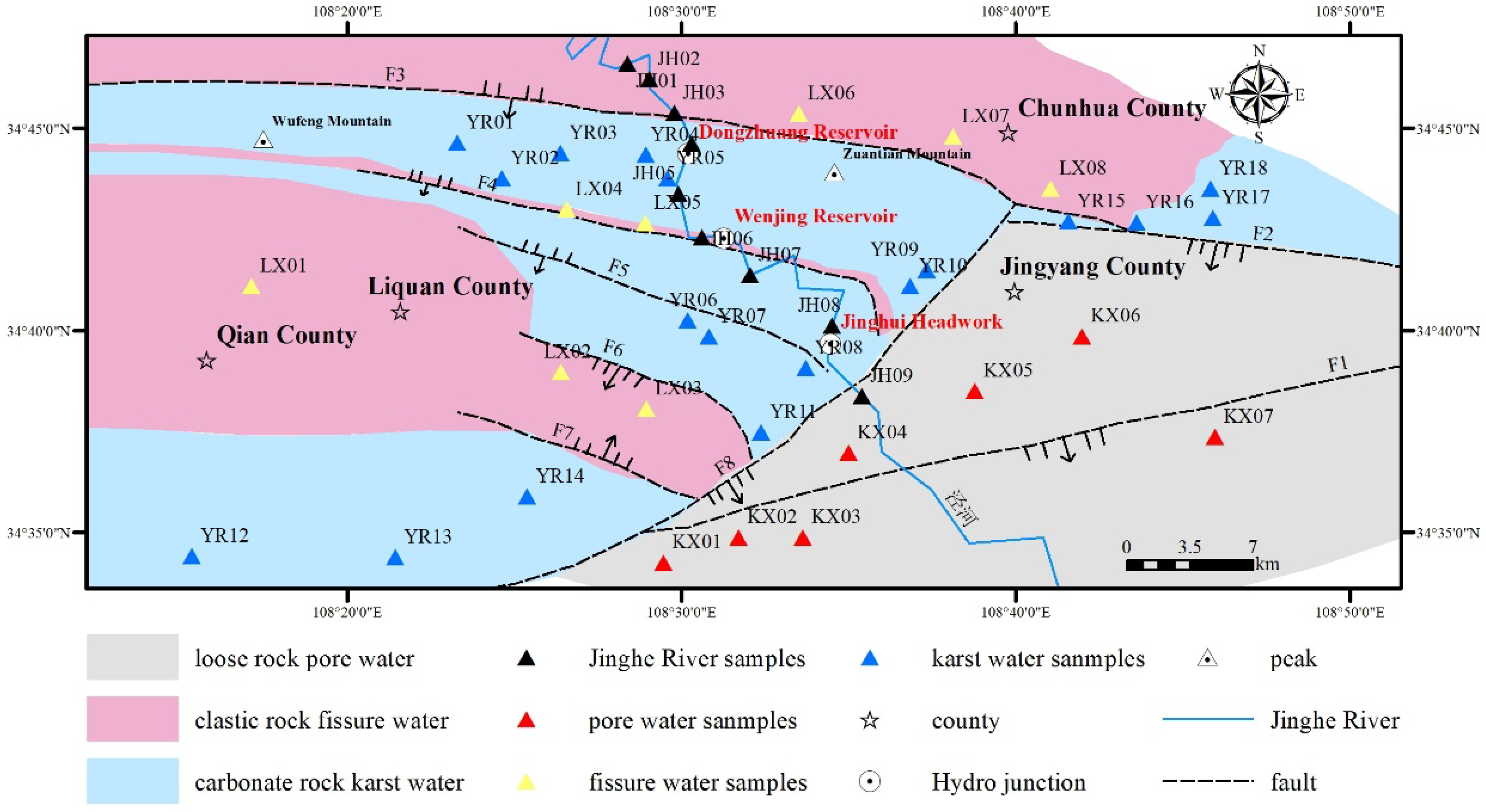
2.1. Site Description

The study area mainly includes parts of Qian County, Liquan County, Jingyang County, and Chunhua County (108°10′00″ E~108°50′00″ E, 34°30′00″ N~34°50′00″ N) in China (Figure 1). The study area is located in the southern edge of the Ordos Basin, mainly developing the Cambrian, Ordovician, Carboniferous, and Permian strata of the Paleozoic. There are various types of rocks, including marine carbonate rock, terrigenous clastic rock, terrigenous clastic rock, and migmatite. Among them, Ordovician limestone and dolomite rocks of Lower Paleozoic are widely exposed at both sides of the dam site and river valley terrace, which has the greatest impact on the project leakage [14].
The local landform, geological structure, and hydrogeological conditions of Dongzhuang dam site area are relatively complex. There are typical landforms in the area, such as a mountain area, a loess hilly area, a piedmont alluvial proluvial plain and a valley terrace area. In terms of geological structure, there are east–west, northeast–east and northwest fault zones. Due to the two strong orogenic movements of Caledonia and Yanshan, the study area has formed the stratigraphic conditions for the development of ancient karst. However, the karst in the study area is mainly the modern karst developed along the valley bank slope since the Quaternary, and it is in the primary stage of development. The karst development is weak, and its forms are mainly karst fissure and karst pore [15]. The groundwater in the study area can be divided into loose rock pore water, carbonate rock karst water and clastic rock fissure water according to the water-bearing medium. The study area has a temperate semi-arid continental monsoon climate, which is mostly controlled by northwest arid cold air flow throughout the year. Evaporation in the region is relatively strong, with less precipitation and uneven spatial and temporal distribution.

2.2. Methods

In order to study the hydrogeochemical characteristics of different water bodies, 42 groups of surface water and groundwater samples were collected in the study area, including 9 groups of Jinghe River water samples, 7 groups of pore water samples, 8 groups of fissure water samples and 18 groups of karst water samples. Test items and methods are shown in Table 1.
Due to the limited space of the article, interested readers can refer to the test specification in Table 1, for the detailed test methods and procedures. The basic principle of the test method is as follows:
(1)
ICP-AES
Inductively coupled plasma atomic emission spectrometer (ICP-AES) is an instrument that uses inductively coupled plasma as excitation light source to determine elements. It analyzes elements according to the characteristic spectral lines emitted when the atom of the element returns to the ground state from the excited state. The energy level structure of different element atoms is different, resulting in different emission-spectral-line characteristics. On this basis, the sample can be qualitatively analyzed. The different concentrations of element atoms leads to different emission intensities, which can realize the quantitative determination of elements.
(2)
Silver nitrate titration
Anions react with chloride ions to form silver chloride precipitates. When potassium chromate indicator exists, excess silver ions react with chromate to form red silver chromate precipitation. The content of chloride ion can be calculated according to the consumption of silver nitrate solution.
(3)
EDTA titration
In sulfuric acid solution, excessive barium chloride solution can quantitatively produce barium sulfate precipitation. The remaining barium ion is titrated with disodium ethylenediaminetetraacetate (EDTA) solution under alkaline conditions (pH = 10). In titration, excessive barium ion is titrated by disodium EDTA. Moreover, calcium and magnesium ions in raw water samples are also titrated. Therefore, the total hardness of the water sample is included in the calculation.
(4)
Acid–base titration
Phenolphthalein and methyl orange can be used as indicators to obtain the concentration of bicarbonate by acid solution titration.
(5)
Glass electrode method
The method utilizes the principle of a chemical battery. The glass electrode is used as the indicator electrode and the saturated calomel electrode as the reference electrode. The two electrodes are diffused into the solution to form a battery. At 25 °C, the potential difference of 59.16 mV will be generated when the pH of solution changes by one unit. After calibration and positioning with standard buffer solution, the electrode is put into the sample, and the pH value directly read on the pH meter or the ionometer.
(6)
Gravimetric method
The total dissolved solids can be obtained after the water sample is evaporated. It is worth noting that the total amount of dissolved solids should be obtained by drying and weighing at 105 °C.
The methods of Shukalev classification, Piper diagram, Gibbs diagram and ion proportion coefficient [16,17] were used to analyze the classical statistical characteristics of hydrogeochemical components in different water bodies, so as to study the hydrogeochemical types and the causes of formation. Then, the Q-type cluster method [18,19] was used to quantitatively analyze the hydrogeochemical composition data of different water bodies and compare the differences between the Jinghe River and the three groundwater bodies, so as to further determine their hydraulic connection.

3. Results and Discussion

3.1. Characteristics of Hydrogeochemical Components in Different Water Bodies

Table 2 shows the classical statistical characteristics of chemical components in different water bodies. The following conclusions can be drawn from Table 2: all water bodies in the study area are weakly alkaline, especially the Jinghe River, whose average pH value is greater than 8; the TDS of Jinghe River and pore water is significantly higher than for fissure water or karst water, and the water quality of a large number of water sample points is brackish water; Na+ (including K+), Cl and SO42− in Jinghe River and pore water are higher than those in fissure water and karst water; and the variation coefficient of cations is generally higher than that of anions, indicating that the variation of cationic components is high, while the content of anions is relatively stable.

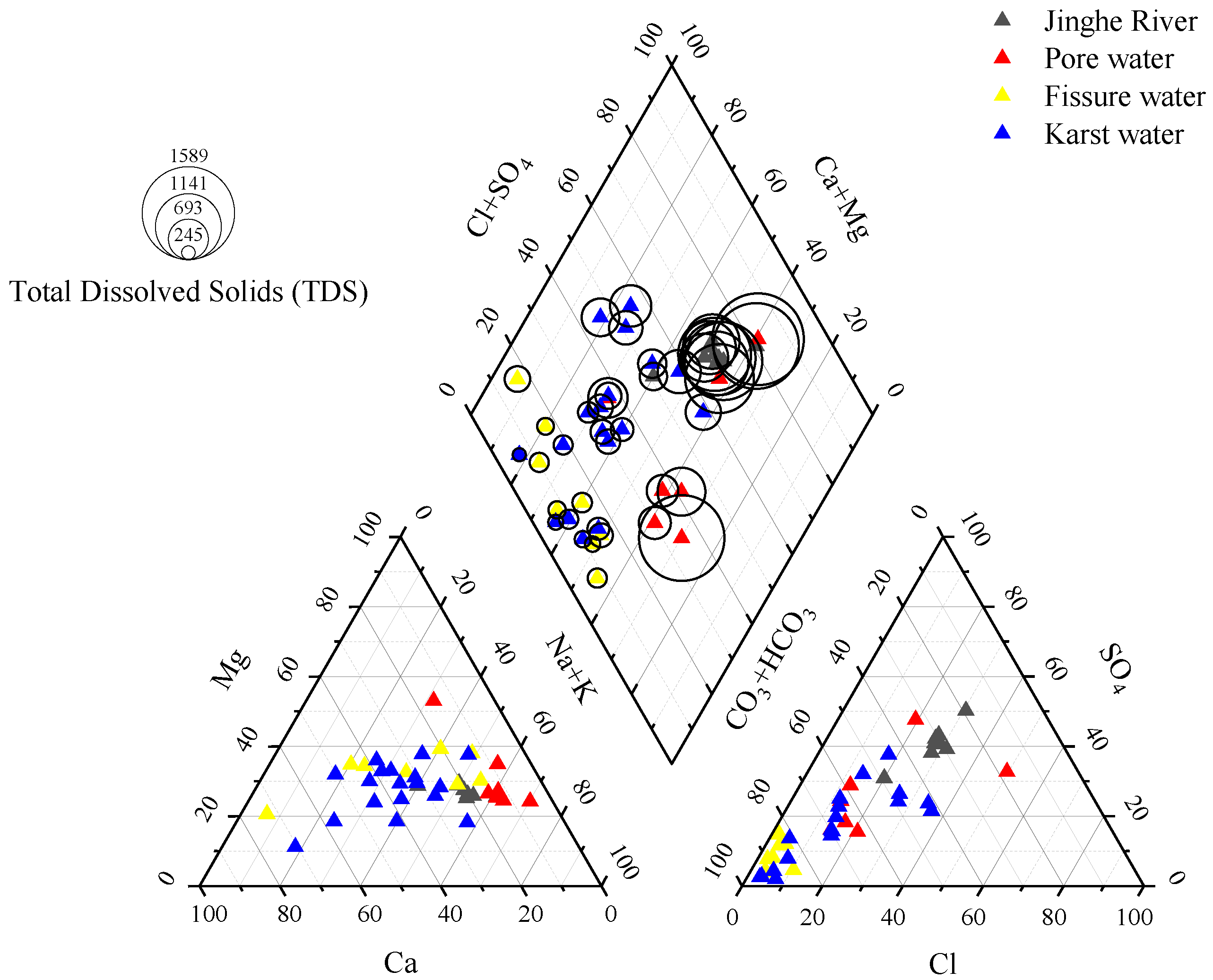
3.2. Characteristics of Hydrogeochemical Types in Different Water Bodies

According to TDS classification, the water body in the study area is mainly fresh water and contains a small amount of brackish water. Brackish water was only found in Jinghe River and pore water, accounting for 56% and 43% of Jinghe River and pore water samples, respectively.
The hydrogeochemical types of the different water bodies were classified according to the Shukalev classification method and it was found that the hydrogeochemical types are diverse. The hydrogeochemical types of Jinghe River mainly contain SO4−Na and HCO3·SO4−Na, the hydrogeochemical types of pore water mainly contain HCO3·SO4−Na and HCO3·SO4−Na·Mg, the hydrogeochemical types of fissure water mainly contain HCO3−Ca and HCO3−Na·Mg, and the hydrogeochemical types of karst water mainly contain HCO3−Na·Ca·Mg, HCO3−Ca·Mg, HCO3·Cl-Na, HCO3·SO4·Cl-Na·Ca and HCO3.Cl-Na·Ca·Mg. In the Jinghe River, cations are mainly Na+ and K+, indicating that the surface water is mainly affected by evaporation and concentration, because of the relatively high TDS content (Na+ and K+ are usually the main cations in the water with high TDS content [20]). The main cations in pore water are Na+ and Mg2+, the main cations in fissure water are Na+, Ca2+ and Mg2+, and the main cations in karst water are Na+, Ca2+ and Mg2+. The different content of cations in pore water, fissure water and karst water reveals that the formation mechanism of groundwater chemistry is complex.
Although Shukalev classification is clear, it is sometimes subjective. This classification cannot show the order of ions contents whose milligram equivalents are greater than 25%, so this method cannot reflect the evolution of ion components. Piper diagrams can not only show the hydrogeochemical characteristics from the diamond chart, but can also objectively reflect the relative content of various ions in the triangle chart. Therefore, Piper diagrams of different water bodies were drawn (Figure 2). As shown in Figure 2, the overall order of TDS content in different water bodies is: pore water > Jinghe River water > karst water > fissure water. The sample points of fissure water and some karst water are located at the lower left of the diamond chart, indicating that the content of strong acid radical is less than that of weak acid radical, that is, the content of HCO3 is higher than that of SO42−, reflecting the dissolution of carbonate rocks in this area. The sample points of Jinghe River, pore water and some karst water levels are located at the lower right of the diamond chart, indicating that the content of some alkali metal ions is higher than that of alkaline earth metal ions, that is, the content of Na+ and K+ is higher than that of Ca2+ and Mg2+. It is speculated that the supply source of these water bodies is mainly from atmospheric precipitation or dissolution of some carbonate minerals. It can be seen from the triangle at the bottom left of Figure 2 that Na+, K+ and Ca2+ are the main cations of all water bodies in the study area. The cations of Jinghe River and pore water mainly include Na+ and K+. Moreover, Na+, K+ and Ca2+ are found in fissure water and most karst water. It can be seen from the triangle diagram at the lower right that the main anions of the water bodies are HCO3 and SO42−. However, the content of Cl in Jinghe River and some pore water is relatively high, indicating that alternative cation adsorption may exist in Jinghe River and pore water. It is also possible that the dissolution of carbonate is less, and there may be hydraulic connection between them.

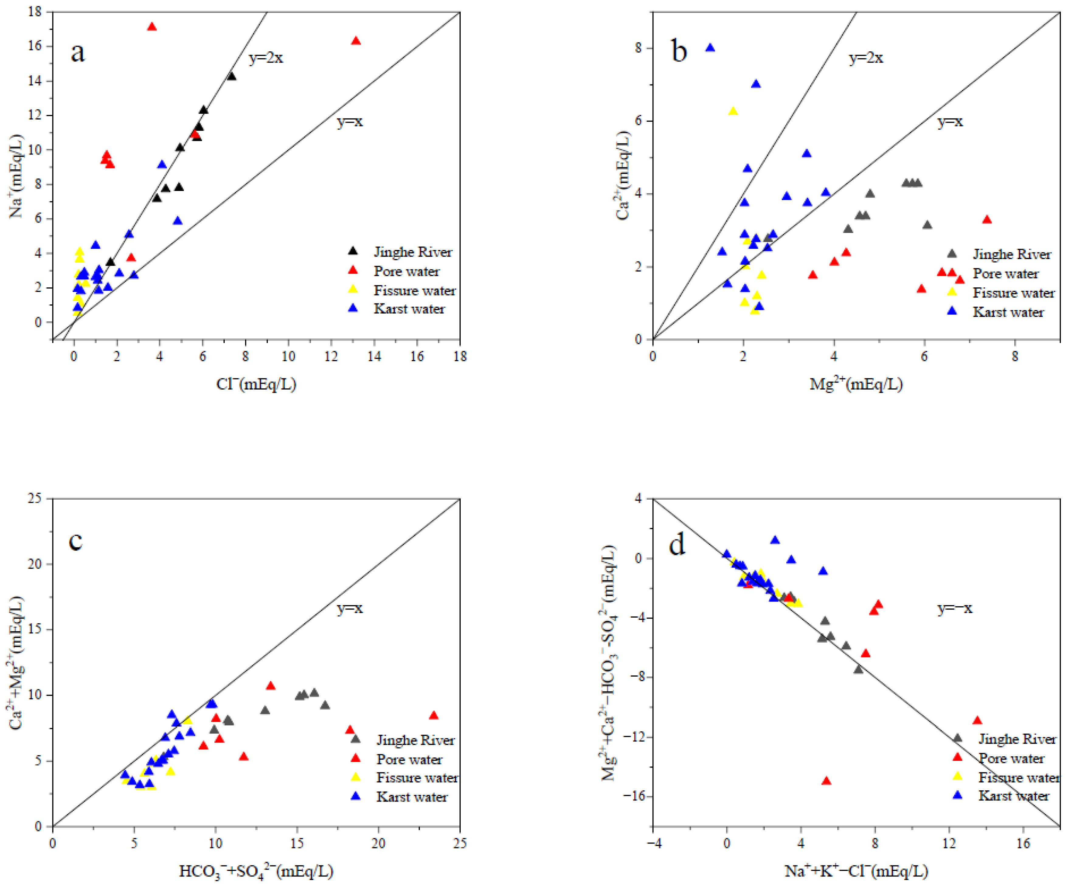
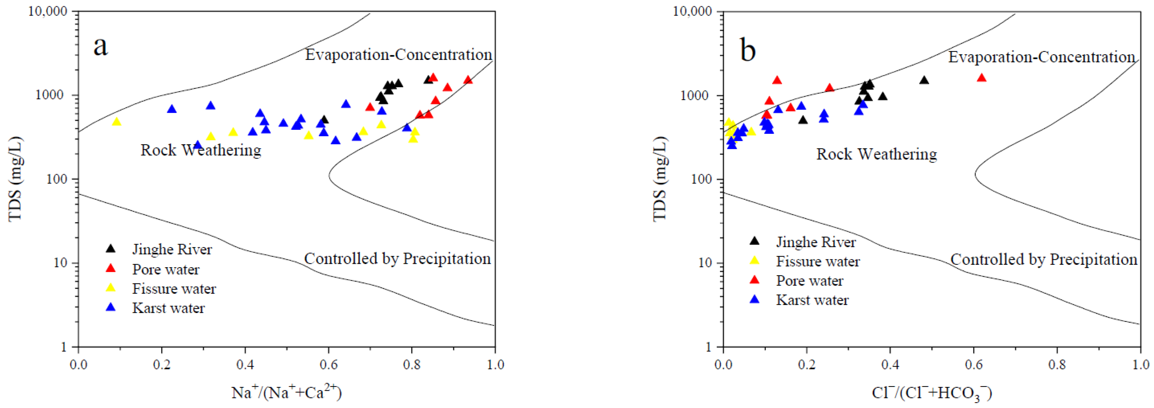
3.3. Hydrogeochemical Origin of Different Water Bodies

The Gibbs diagram is often used to qualitatively judge the hydrogeochemical genesis mechanism, which can simply and intuitively reflect results. It determines the hydrogeochemical origin by analyzing the relationship between Na+/(Na+ + Ca2+) and TDS content as well as Cl/(Cl + HCO3) and TDS content [21].
As shown in Figure 3, all water sampling points are basically located in the middle upper part of the Gibbs map, and some of the Jinghe River and pore water sampling points are located outside the action line. Due to the long-term dissolution of fissure water and karst water with carbonate rocks, the concentrations of Ca2+ and HCO3 are relatively high. Therefore, the fissure water and karst water in the study area are mainly affected by rock weathering. Due to shallow burial depth of pore water and dry climate, Jinghe River and pore water are experiencing relatively strong evaporation. Due to the evaporation, the contents of Ca2+, Mg2+ and HCO3 will decrease through carbonate precipitation, leading to the increase of the value of Na+/(Na+ + Ca2+) and Cl/(Cl + HCO3). Therefore, Jinghe River and some pore water are mainly affected by evaporation concentration.
The ion proportion coefficient can reflect the formation of hydrogeochemical components. In this article, the four ion proportion coefficients are analyzed deeply according to the research needs (Figure 4).
The milligram equivalent ratio of Na+ to Cl (γ Na+/γ Cl) can reflect the hydrogeochemical characteristics of seawater components. The ratio (γ Na+/γ Cl) in pure sea water is about 0.85, while that of other inland water is usually greater than 1 [22]. When the ratio (γ Na+/γ Cl) is close to 1, both ions come from the dissolution of sodium containing soluble salt minerals. It can be seen from Figure 4a that almost all the sample points fall on the upper left of the line y = x, that is the ratio (γ Na+/γ Cl) is greater than 1, indicating that Na+ in all water bodies in the study area is likely to be dissolved by silicate minerals. Due to the arid climate and the impact of human activities, Jinghe River is experiencing strong evaporation. With evaporation and concentration, Mg2+, Ca2+ and SO42− gradually reach saturation and precipitation, forming high TDS water dominated by Na+ and Cl. Even most of the pore water and fracture water samples are located at the upper part of the line y = 2x. In fact, there is a large number of albites exposed in the Ordovician strata in the middle and east of the study area, which leads to redundant sources of Na+.
Mg2+ and Ca2+ in groundwater mainly come from the dissolution of dolomite and calcite, and Figure 4b shows the relationship between the milliequivalents of Mg2+ and Ca2+. It can be seen from this figure that all the karst water sample points are located at the upper part of the line y = x, that is, γ Ca2+/γ Mg2+ is greater than 1. The ratio of calcium to magnesium content in karst water is obviously different from that in other water bodies, which indicates that karst water is dissolved by a large amount of calcite. Different cations have different capacities to adsorb on the surface of rock and soil. According to the adsorption capacity, the order is [20]: H+ > Fe3+ > Al3+ > Ca2+ > Mg2+ > K+ > Na+. However, the other water sample points in the area are basically located near the lower part of the line y = x, and the relative decrease of Ca2+ content indicates that some Ca2+ may be adsorbed alternatively by cations.
It can be seen from Figure 4c that most of the sample points of karst water and fissure water in the area are located near the lower part of the line y = x. Combined with Figure 4a, it can be seen that karst water and fissure water are mainly weathered and dissolved by carbonate minerals [23]. However, Mg2+ and Ca2+ in Jinghe River and pore water in the area may be adsorbed by albite bearing surrounding rock, which results in the alternating adsorption of cations.
The milligram equivalent relationship between [Na+ + K+ − Cl] and [Ca2+ + Mg2+ − HCO3 − SO42−] can reflect the exchange between Ca2+, Mg2+ and Na+, K+ in the cation alternative adsorption. As shown in Figure 4d, except for some pore water and karst water, all water sample points in the area are basically located on the line y = −x. This indicates that cation exchange has taken place in Jinghe River, pore water, fissure water and most karst water in the study area. Moreover, Ca2+ and Mg2+ that participate in the cation alternating adsorption mainly come from dolomite and calcite, while Na+ and K+ may also come from atmospheric precipitation or human activities.

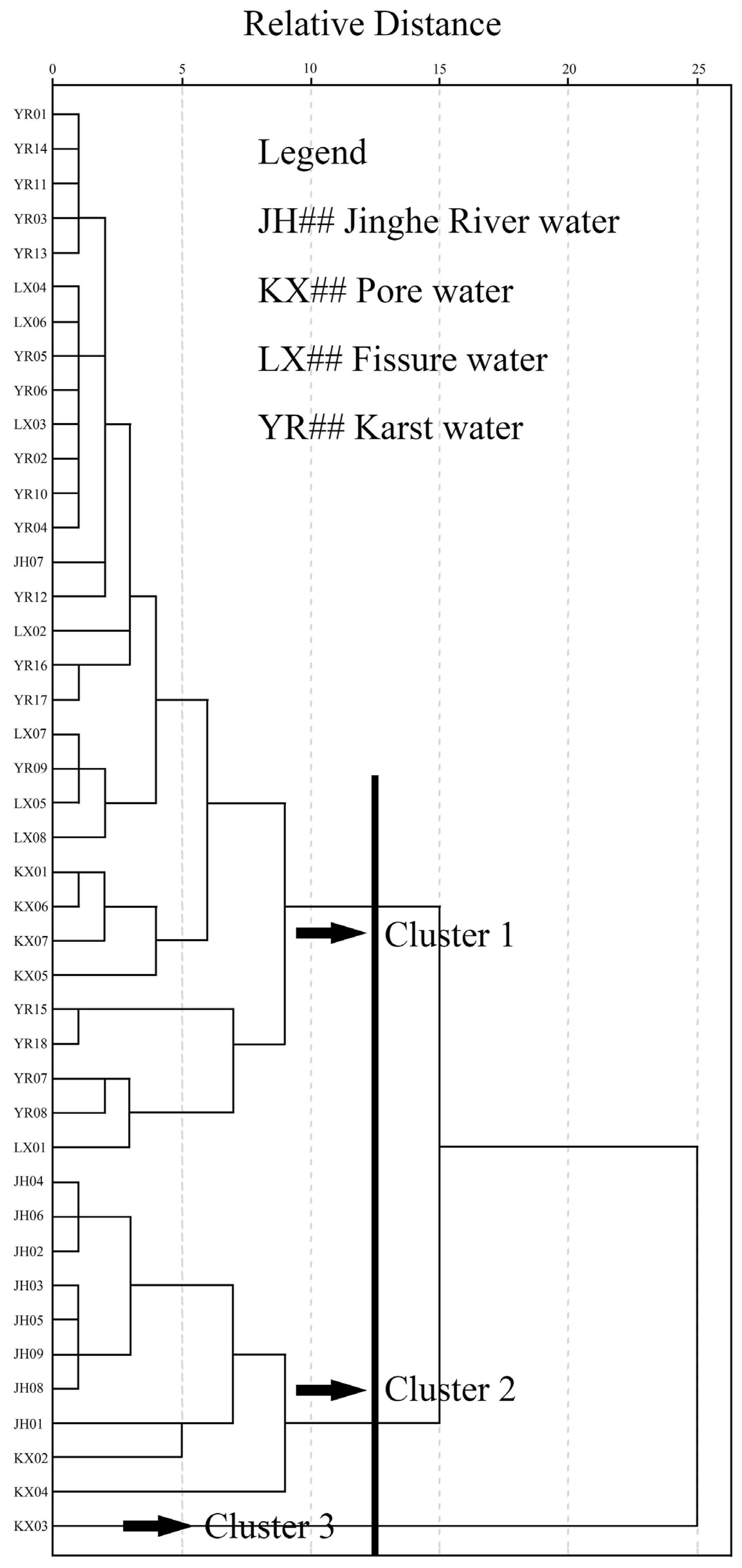
3.4. Hydraulic Connection of Different Water Bodies

From the hydrogeochemical characteristics and causes of different water bodies in the study area discussed above, it can be concluded that the hydrogeochemical characteristics of Jinghe River are obviously different from those of fissure water and karst water, while Jinghe River and pore water are somewhat similar. Specifically, the mean TDS content of Jinghe River and pore water is more than 1000 mg/L, while that of fissure water and karst water is less than 500 mg/L. The content of SO42− and Na+ in Jinghe River and pore water is also much higher than that in fissure water and karst water. According to the recharge and discharge law of groundwater chemistry, the fissure water and karst water in the area receive little direct recharge from Jinghe River and pore water. The main anionic chemical compositions (Cl and HCO3) of Jinghe River and pore water are relatively similar, indicating that there may be some hydraulic connection between Jinghe River and pore water. It is speculated that they should be jointly recharged by atmospheric precipitation.
The above inferences from the perspective of hydrogeochemical characteristics and hydrogeochemical genesis are still qualitative analysis. In order to quantitatively assess the relationship between water bodies, the Q-type cluster method is used to further analyze the hydrogeochemical data of 42 groups of water bodies, so as to determine the hydraulic connection of different water bodies. In order to unify the dimensions, 42 groups of hydrogeochemical data are first normalized, the Euclidean square distance is used as the similarity matrix, and the sum of squares of deviations is used to classify the water sample points to obtain the cluster tree of water sample points (Figure 5).
It can be seen from Figure 5 that in the case of three classifications, except for the JH07 sample point of Jinghe River, Jinghe River and two groups of pore water sample points are classified into one category, all karst water, fissure water and some pore water are classified into one category, and pore water sample point KX03 is classified, separately, into another category. As the JH07 sample point of Jinghe River is close to Wenjing Reservoir and affected by human activities, its TDS value is obviously low, which is different from the hydrogeochemical characteristics of Jinghe River. The main reason for the separate classification of KX03 is that its HCO3 content is significantly higher than that of other pore water samples. This place is located in the southwest of Jingyang County, far from other pore water and close to the spring field at the downstream of Jinghe River. The strong dissolution of carbonatite and weak evaporation-concentration lead to its distinctive hydrogeochemical characteristics. This shows that pore water is located in the key zone of water circulation of atmospheric precipitation, surface water and groundwater. Therefore, the hydrogeochemical characteristics of individual pore water is different from that of other water bodies. Due to long-term dissolution and filtration, the cluster statistics show that the hydrogeochemical components of some pore water are different from those of Jinghe River. However, the water quality of fissure water and karst water is similar, which is consistent with the results of previous analyses.

4. Conclusions

(1)
In general, Jinghe River and pore water are weakly alkaline, with high TDS value (brackish water). Na+ and K+ are the main cations in Jinghe River, while Cl and SO42− are the main anions. HCO3− and SO42− are the main anions of pore water, fissure water and karst water, and the content of cations is different, indicating that the formation mechanism of the hydrochemistry is complex.
(2)
There are many hydrogeochemical types of water bodies in the study area. Jinghe River and some pore water are mainly subjected to evaporation-concentration. Fissure water and karst water are mainly subjected to rock-weathering. The main source of Ca2+ and Mg2+ in karst water and fissure water should be the weathering dissolution of carbonate minerals. The main reason for the unstable distribution of cations is that the water body in the study area has undergone different degrees of cation exchange.
(3)
According to the hydrogeochemical origin and cluster analysis, the chemical composition of the Jinghe River is obviously different from the hydrogeochemical composition of the fissure water and karst water in the area. It can be inferred that the Jinghe River has hydraulic connection with pore water, but there is almost no hydraulic connection between Jinghe River and the regional karst water. This shows that it is difficult for the Jinghe River to recharge karst groundwater through leakage. However, the specific hydraulic recharge and discharge relationship between water bodies needs to be further analyzed by means of runoff characteristics and isotope chemistry.

Author Contributions

Conceptualization, H.Z. and J.Z.; methodology, H.Z. and J.Z.; software, J.Z.; validation, H.Z., W.W. and J.W.; formal analysis, H.Z.; investigation, H.Z. and W.W.; resources, H.Z. and W.W.; data curation, H.Z.; writing—original draft preparation, J.Z.; writing—review and editing, H.Z. and W.W.; visualization, J.Z.; supervision, H.Z.; project administration, W.W.; funding acquisition, H.Z. and W.W. All authors have read and agreed to the published version of the manuscript.

Funding

Key R&D and Promotion Projects of Henan Province (212102311150).

Data Availability Statement

Not applicable.

Conflicts of Interest

The authors declare no conflict of interest. The funders had no role in the design of the study nor in the manuscript of data or the writing of the manuscript.

References

  1. Ren, A.W.; Ke, B.R.; Cheng, J.S.; Sun, P.; Duan, Q.W.; Shao, Y. Barrier effect of covered sheet pile wharfs with diaphragm walls. J. Hydraul. Eng. 2014, 45 (Suppl. 2), 119–124. [Google Scholar] [CrossRef]
  2. Teng, Y.G.; Zuo, R.; Wang, J.S.; Lin, X.Y. Progress in geochemistry of regional groundwater evolution. Adv. Water Sci. 2010, 21, 127–136. [Google Scholar] [CrossRef]
  3. Wang, H.; Jiang, X.W.; Wan, L.; Han, G.L.; Guo, H.M. Hydrogeochemical characterization of groundwater flow systems in the discharge area of a river basin. J. Hydrol. 2015, 527, 433–441. [Google Scholar] [CrossRef]
  4. Guo, X.; Wang, H.W.; Shi, J.S.; Wang, W. Hydrochemical characteristics and evolution pattern of groundwater system in Baiyangdian wetland, North China Plain. Acta Geol. Sin. 2022, 96, 656–672. [Google Scholar] [CrossRef]
  5. Chen, B.; Su, W.C. Analysis on the Karst Seepage of Maguan Underground Reservoir. Earth Environ. 2005, 33, 237–241. [Google Scholar] [CrossRef]
  6. Tang, J. Research on the Karst Developing Characteristics and Seepage in Dam Area of Charikou Hydropower Station. Master’s Thesis, Chengdu University of Technology, Chengdu, China, 2014. [Google Scholar]
  7. Tong, J. Research on Hydrogeological Conditions of Leakage in Qianwei Hydropower Station Dam Site. Master’s Thesis, Chengdu University of Technology, Chengdu, China, 2011. [Google Scholar]
  8. Dai, Z.H.; Zhu, Y.H.; Lu, P.; Li, Z.S.; Zhao, X.R. Development characteristics and leakage of atypical concealed karst: Taking Daxueshan reservoir as an example. J. Guilin Univ. Technol. 2021, 41, 518–524. [Google Scholar] [CrossRef]
  9. Mao, C.P.; Yang, Z.Y.; Li, G.K.; Zhang, L.; Rao, W.B. Major ion chemistry of Pumped Storage Power Station Reservoir: Controlling mechanisms and tracing implications for Reservoir Water Leakage. J. Hohai Univ. Nat. Sci. 2022. Available online: https://kns.cnki.net/kcms/detail/32.1117.TV.20220527.1850.004.html (accessed on 4 December 2022).
  10. Wan, W.F.; Wang, Q.W.; Zou, J.F.; Miao, W. Discussion on Several Key Problems about Karst Leakage of Dongzhuang Reservoir. Yellow River 2015, 37, 99–103. [Google Scholar] [CrossRef]
  11. Lei, C.R.; Song, X.L.; Wang, Q.W. Research on Impact of Underground Water Environment of Dongzhuang Reservoir of Jinghe River. Yellow River 2018, 40, 97–99. [Google Scholar] [CrossRef]
  12. Wang, Y.W. The Karst Leakage Study on Jinghe Dongzhuang Reservoir. Ph.D. Thesis, China University of Geosciences (Beijing), Beijing, China, 2014. [Google Scholar]
  13. Du, P.Z.; Lei, C.R.; Gao, P. Research on Controlling Factors and Development Rules of Karst in Carbonate Rocks of Dongzhuang Reservoir. J. N. China Univ. Water Resour. Electr. Power Nat. Sci. Ed. 2018, 39, 88–92. [Google Scholar] [CrossRef]
  14. Zhao, R.; Zuo, S.Y.; Li, H.; Zhang, Y. Characteristics of Sedimentary Facies of Lower Paleozoic Ordovician Reservoir in Weibei Dongzhuang Area. J. Guizhou Univ. Nat. Sci. 2015, 32, 43–48. [Google Scholar] [CrossRef]
  15. Li, Q.B.; Wan, W.F.; Liu, J.L.; Zhou, Y.M. Study on Karst Leakage of Dongzhuang Reservoir in Jinghe River; China Water & Power Press: Beijing, China, 2021; pp. 45–47. [Google Scholar]
  16. Reddy, A.G.; Kumar, K.N. Identification of the Hydrogeo-Chemical Processes in Groundwater Using Major Ion Chemistry: A Case Study of Penna-Chitravathi River Basins in Southern India. Environ. Monit. Assess. 2010, 170, 365–382. [Google Scholar] [CrossRef] [PubMed]
  17. Abdelkader, O.; Larbi, D.; Rihab, H. Geochemical characterization of groundwater from shallow aquifer surrounding Fetzara Lake N.E. Algeria. Arab. J. Geosci. 2012, 5, 1–13. [Google Scholar] [CrossRef]
  18. Wang, J.Y.; Wang, J.L.; Jin, M.G. Hydrochemical Characteristics and Formation Causes of Karst Water in Jinan Spring Catchment. Earth Sci. 2016, 42, 821–831. [Google Scholar] [CrossRef]
  19. Han, Y.P.; Zhang, D.Q.; Liu, Z.P. Study on the Hydrochemical Characteristics of Groundwater in the People’s Victory Canal Irrigation Area. Yellow River 2018, 40, 85–90. [Google Scholar] [CrossRef]
  20. Zhang, R.Q.; Liang, X.; Jin, M.G.; Wan, L.; Yu, Q.C. General Hydrogeology, 3rd ed.; Geology Press: Beijing, China, 2010; pp. 54–69. [Google Scholar]
  21. Du, Q.H.; Qu, J.H.; Song, Q.X. An Analysis of Chemical Characteristics and Causes of Groundwater near the Yellow River in Kaifeng City. China Rural Water Hydropower 2020, 62, 172–176. [Google Scholar] [CrossRef]
  22. Feng, X.; Zhang, Y.Z. An Analysis of the Ions Ratio Coefficients of Groundwater in Shenzhou Area. China Rural Water Hydropower 2014, 56, 18–24. [Google Scholar] [CrossRef]
  23. Han, Y.; Bian, J.M.; Gu, T.X.; Tian, X.P.; Fang, Z. Hydrochemical Parameter Characteristics and Evolution Laws of Groundwater in Songyuan City. J. Jilin Agric. Univ. 2016, 38, 175–181. [Google Scholar] [CrossRef]
Figure 1. Groundwater types and distribution of sampling points in the study area.
Water 14 04111 g001
Figure 2. Piper diagram of different water bodies.
Water 14 04111 g002
Figure 3. Gibbs diagram of different water bodies.
Water 14 04111 g003
Figure 4. Ion proportion relationship of different water bodies.
Water 14 04111 g004
Figure 5. Clustering tree of water samples in the study area.
Water 14 04111 g005
Table 1. Test items and methods of water chemical composition.
Test ItemsTest MethodApparatus (Model)Test Specification
Na+ICP-AESICP-AES (optima2100DV)GB/T5750.6-2006(CN)
K+ICP-AESICP-AES (optima2100DV)GB/T5750.6-2006(CN)
Ca2+ICP-AESICP-AES (optima2100DV)GB/T5750.6-2006(CN)
Mg2+ICP-AESICP-AES (optima2100DV)GB/T5750.6-2006(CN)
ClSilver nitrate titrationBuretteDZ/T0064.50-1993(CN)
SO42−EDTA titrationBuretteDZ/T0064.64-1993(CN)
HCO3Acid–base titrationBuretteDZ/T0064.49-1993(CN)
pHGlass electrode methodIonometer (PXSJ-226)DZ/T0064.5-1993(CN)
TDSGravimetric methodElectronic balance (AE160)DZ/T0064.9-1993(CN)
Table 2. Classical statistical characteristics of chemical components of different water bodies.
Water BodyStatisticsNa+ (mg/L)K+ (mg/L)Ca2+ (mg/L)Mg2+ (mg/L)Cl (mg/L)SO42− (mg/L)HCO3 (mg/L)Ph (−)TDS (mg/L)
Jinghe RiverMinimum19.393.0155.3130.5060.26126.32255.068.10498.6
Maximum326.809.4585.5772.78260.91581.06396.638.301483.3
Mean216.436.3372.2358.89176.03357.01323.748.141080.0
CV 10.010.290.170.220.320.370.180.290.28
Pore waterMinimum85.220.9127.4542.4051.4483.41286.797.80570.00
Maximum393.307.2865.5388.57466.52663.44869.548.301589.72
Mean250.113.0140.9865.64150.59253.14517.067.97996.24
CV 10.420.760.310.280.990.840.350.020.43
Fissure waterMinimum12.640.2115.5521.265.6711.32262.147.30294.00
Maximum93.226.21125.0528.8018.8460.04428.978.40469.31
Mean51.513.2046.1425.749.2627.50342.477.91363.81
CV 10.540.740.760.090.460.630.150.040.17
Karst waterMinimum19.210.5917.8515.195.676.24263.007.30249.34
Maximum209.507.05159.9245.81171.58215.65369.788.30764.09
Mean73.272.9669.0328.3652.0680.27320.367.70470.38
CV 10.600.660.540.280.910.770.080.030.32
Notes: 1 CV, coefficient of variation; CV = standard deviation/mean.
Publisher’s Note: MDPI stays neutral with regard to jurisdictional claims in published maps and institutional affiliations.

