
Real-Time Groundwater Dynamics Verification in the Embankment’s Substrate during the Transition of a Flood Wave

Abstract
:1. Introduction
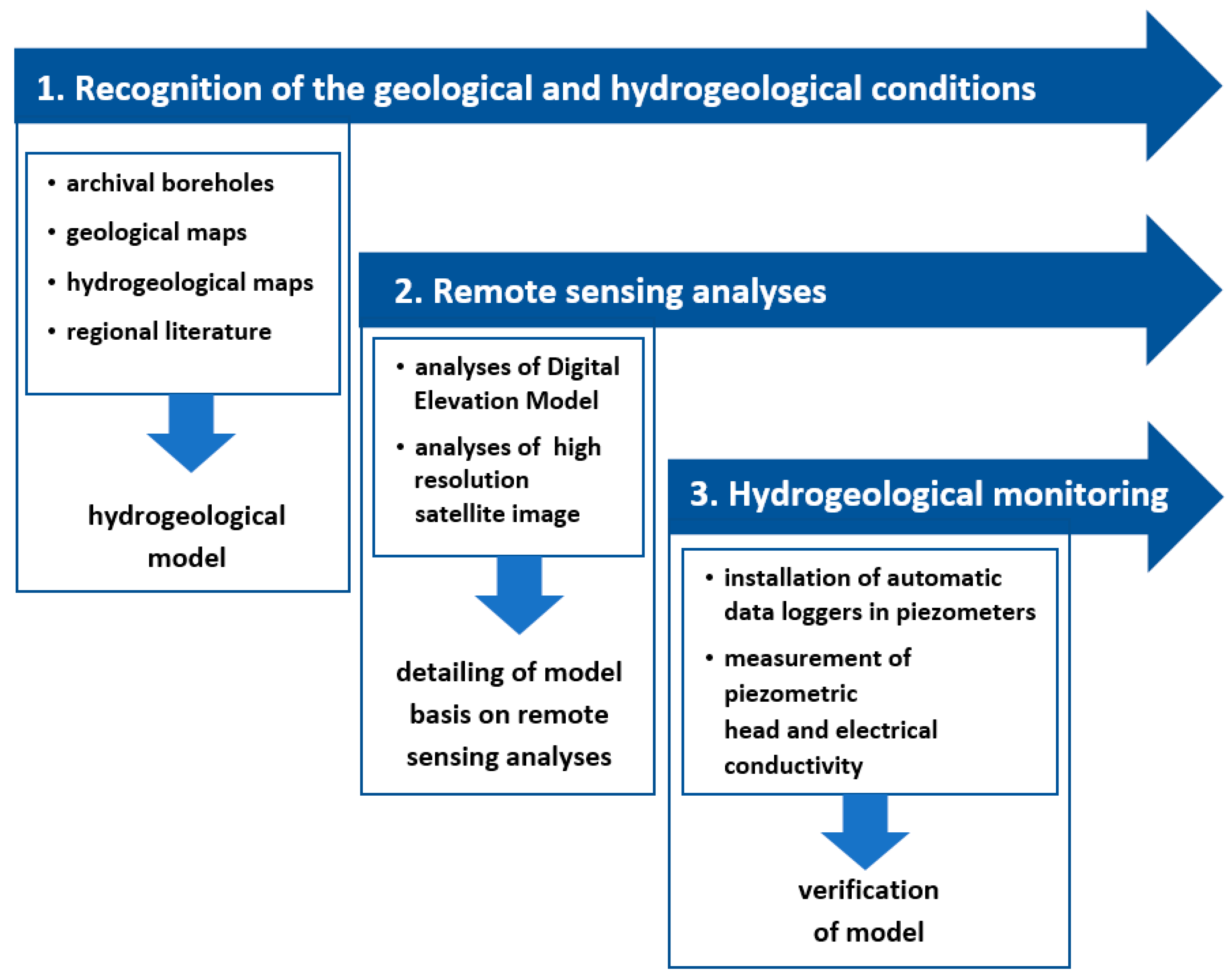
2. Materials and Methods
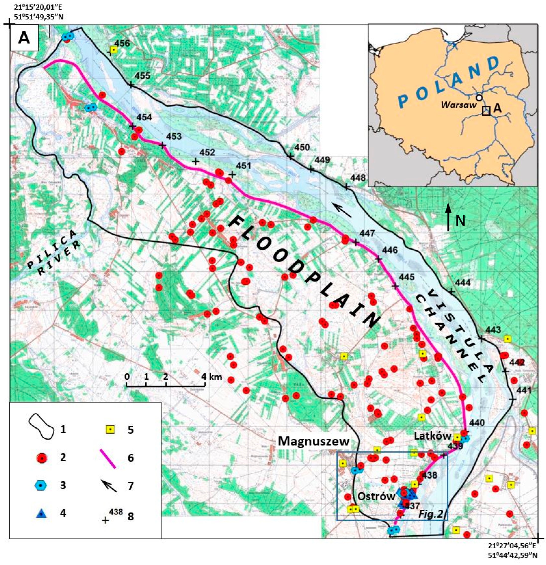
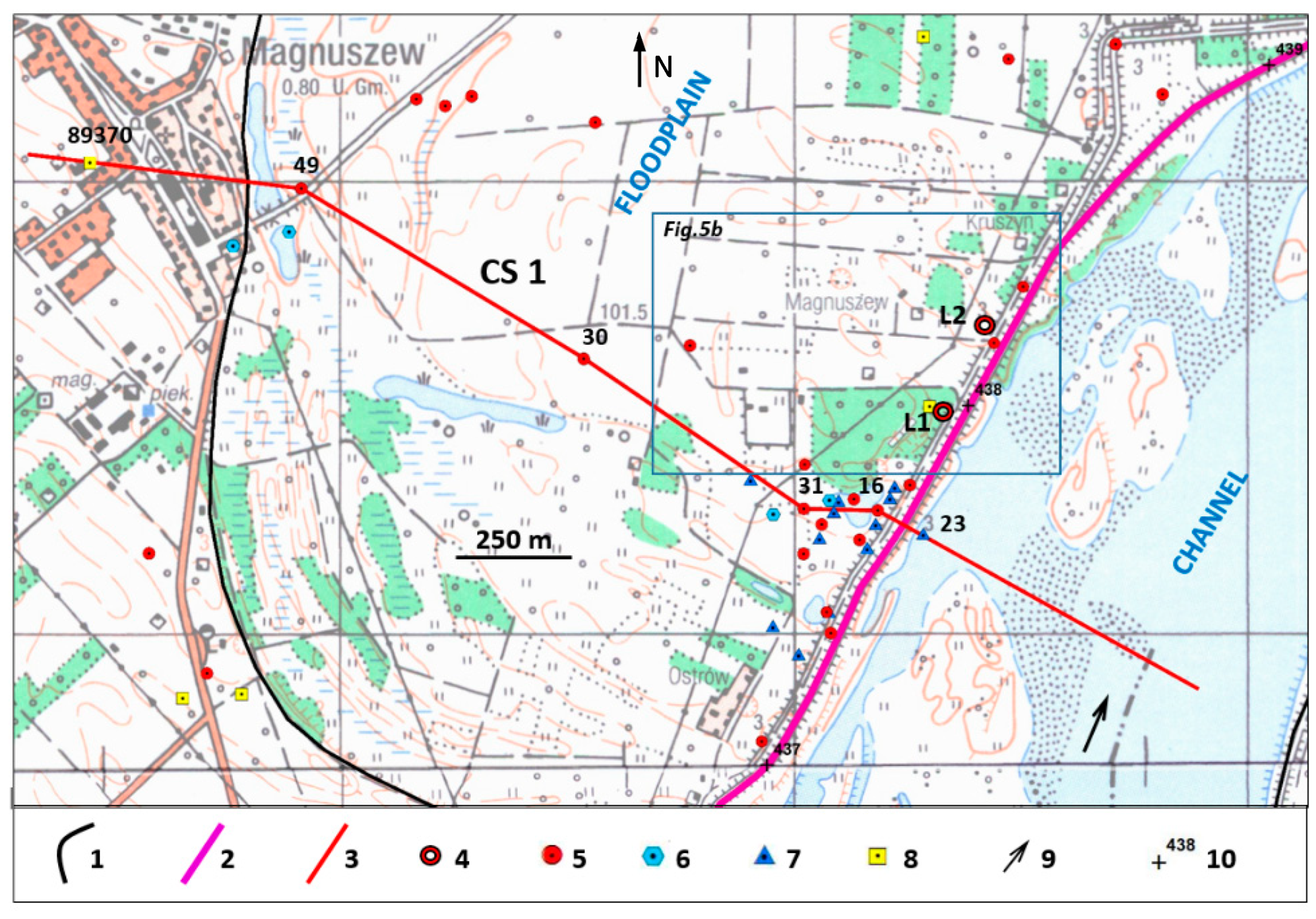
2.1. Location of Study Area
2.2. Methodology
2.2.1. Geological and Hydrogeological Background
- (1)
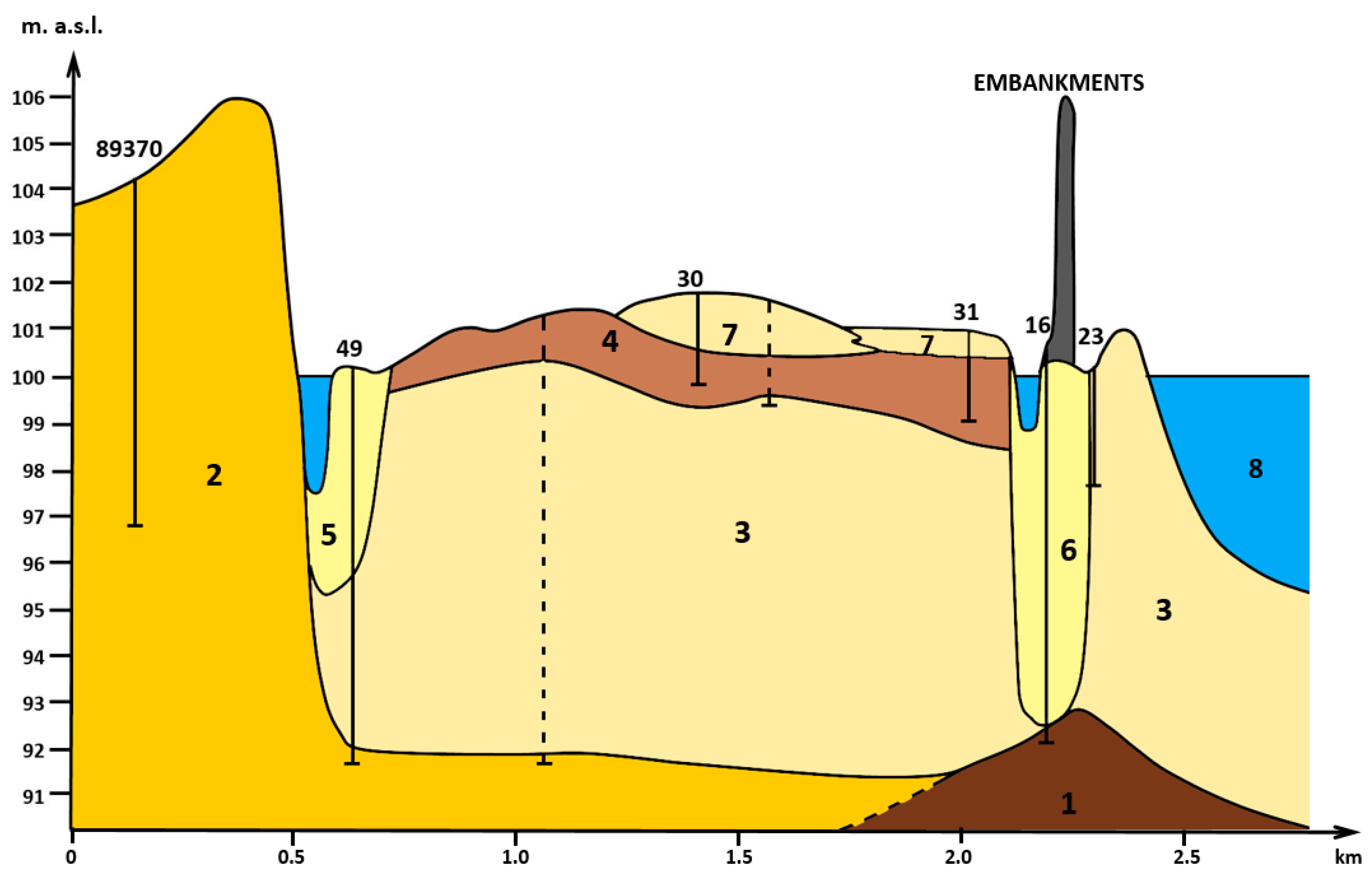
- The first one consists of the alluvia of a braided river, which functioned here at the end of Last Glacial Period and transition to early Holocene [12,15,34,35,36]. They are mostly medium and coarse sands (Figure 3 and Figure 4). Those deposits build up the upper terrace of Vistula valley, as well as partly substratum of Holocene alluvia.
- (2)
- The second series consists of meandering river alluvia deposited in the Holocene up to 300 years BP [12]. Due to the considerable decrease in the dynamics of channel processes, resulting, e.g., from the development of dense plant cover on the basin area, that limit surface runoff [14], fine-grained material was deposited during the surges on the floodplain area [37]. This resulted in the considerable thickness of surge sediments formed as loams and silty loams; their thickness reaches 7 m in the studied area [18] (Figure 3 and Figure 4).
- (3)
- The third series origin is a result of changes in the hydrologic regime related to basin area management starting effectively about 300 years BP (according to the concept presented by [12,15]). Uneven discharges of contemporary river caused deposition of more differentiated alluvia. The channel deposits are medium and coarse sands with gravel intercalations. The flood deposits consist of sediment ranges from sands, silty sands, silts, to silty loams, loams and clays. More often, the flood sediments of a modern braided river occur in the top part of the complex of the Holocene sediments, above loamy muds (Figure 4). However, in the zones of concentrated flood flows, loamy flood deposits were removed and replaced by the silty and sandy muds of the contemporary river.
- (1)
- Near-surface aquifers built of fine sands with intermittences of dust and clay sediments of flood flows of the contemporary, braided Vistula River. Sand filtration coefficient values are 6 × 10⁻⁶ m/s based on laboratory tests. These sediments do not form a continuous cover over the entire area of the floodplain within the research polygon. The level within the distal floodplain is underlined with a series of poorly permeable flood formations with a thickness of 1 m up to 4 m. Groundwater table of this level, under conditions of average rainfall, remains at a depth of 99–101 m above sea level. This level is not exploited.
- (2)
- The second aquifer is made of multi-grained sands and gravels with a thickness of 1.5 m to 9 m-sediments of the channel facies of both the meandering and braided Vistula. This is the main level aquifer in the floodplain area. The coefficients of permeability of these deposits (measured by laboratory method) are from 8 × 10⁻⁶ to 2 × 10⁻⁵ m/s. In the entire area of the floodplain, outside the zone’s erosive cuts in a series of flood formations (filled crevasses and overflow channels), ditches and oxbow lakes, the second-level head stabilizes at the ordinate from about 99 up to 100 m above the sea level.
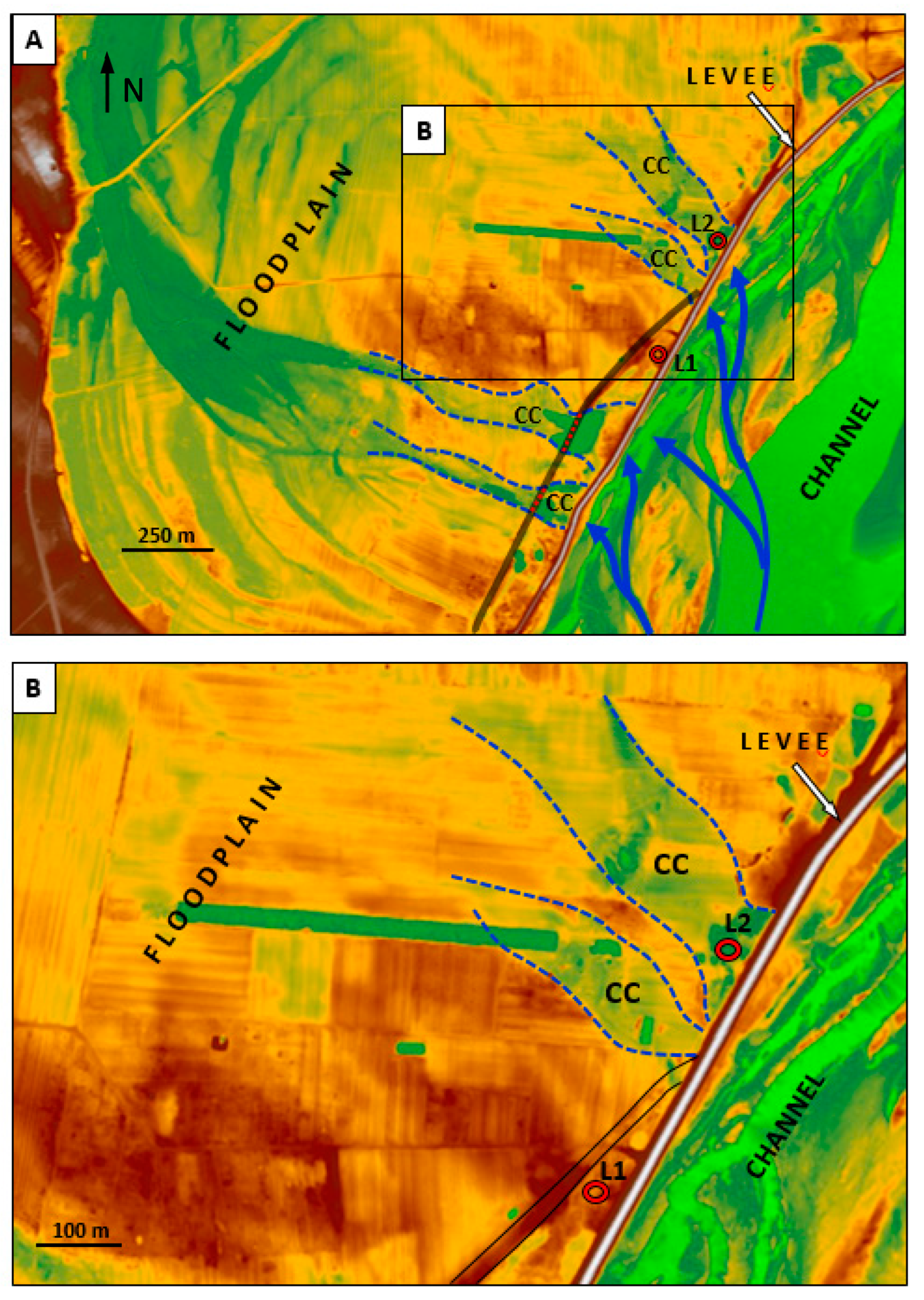
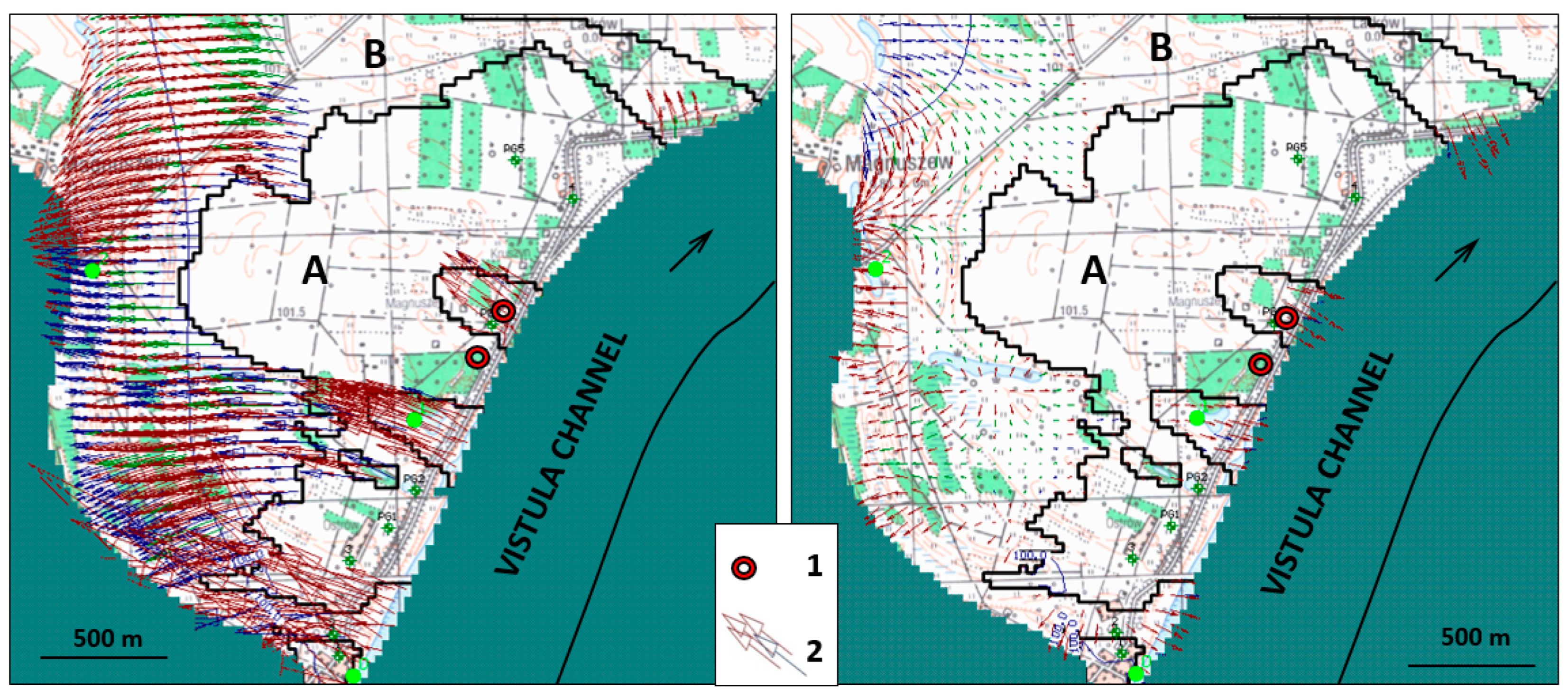
2.2.2. Remote-Sensing Analyses and Groundwater Dynamics Measurements
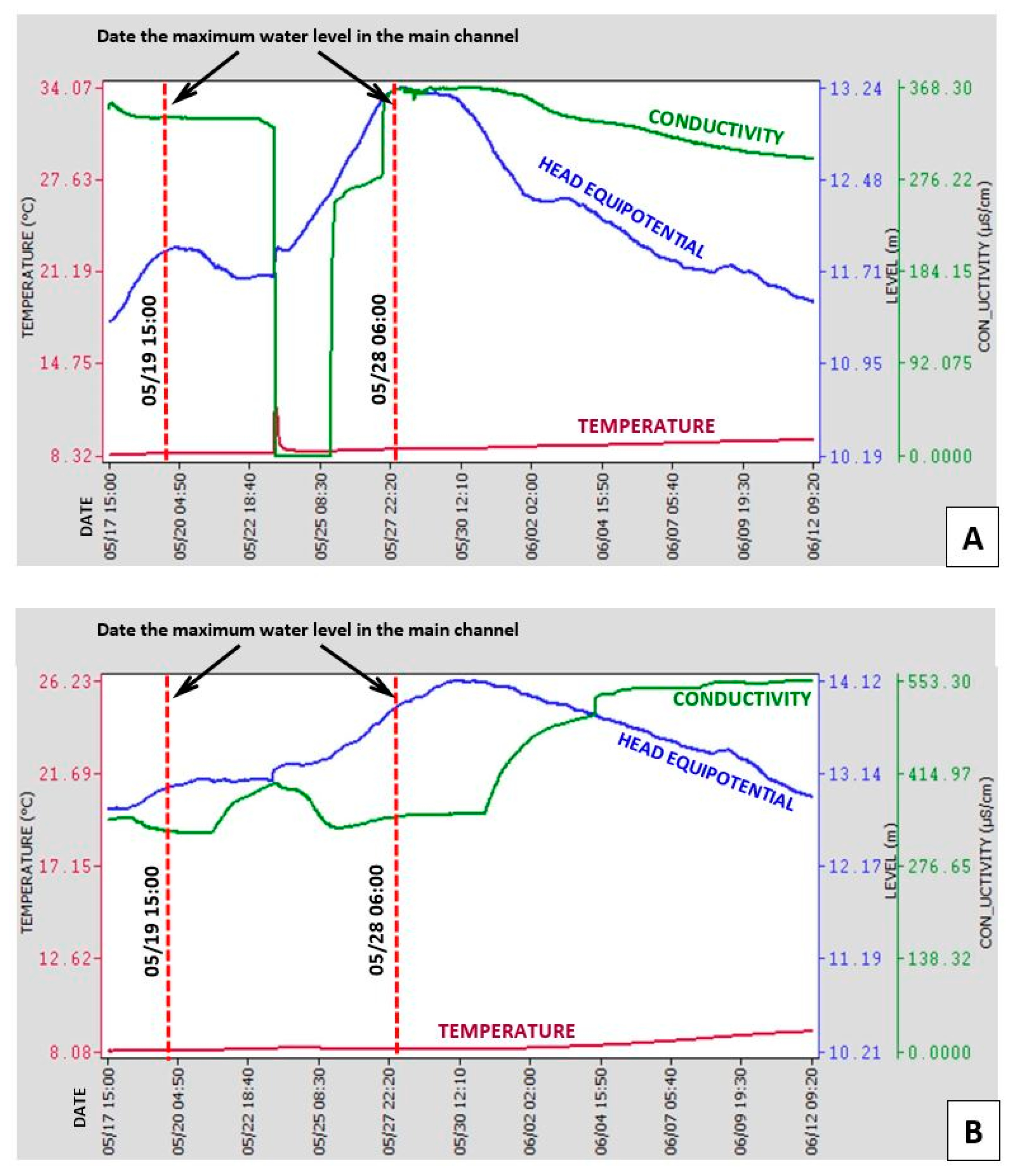
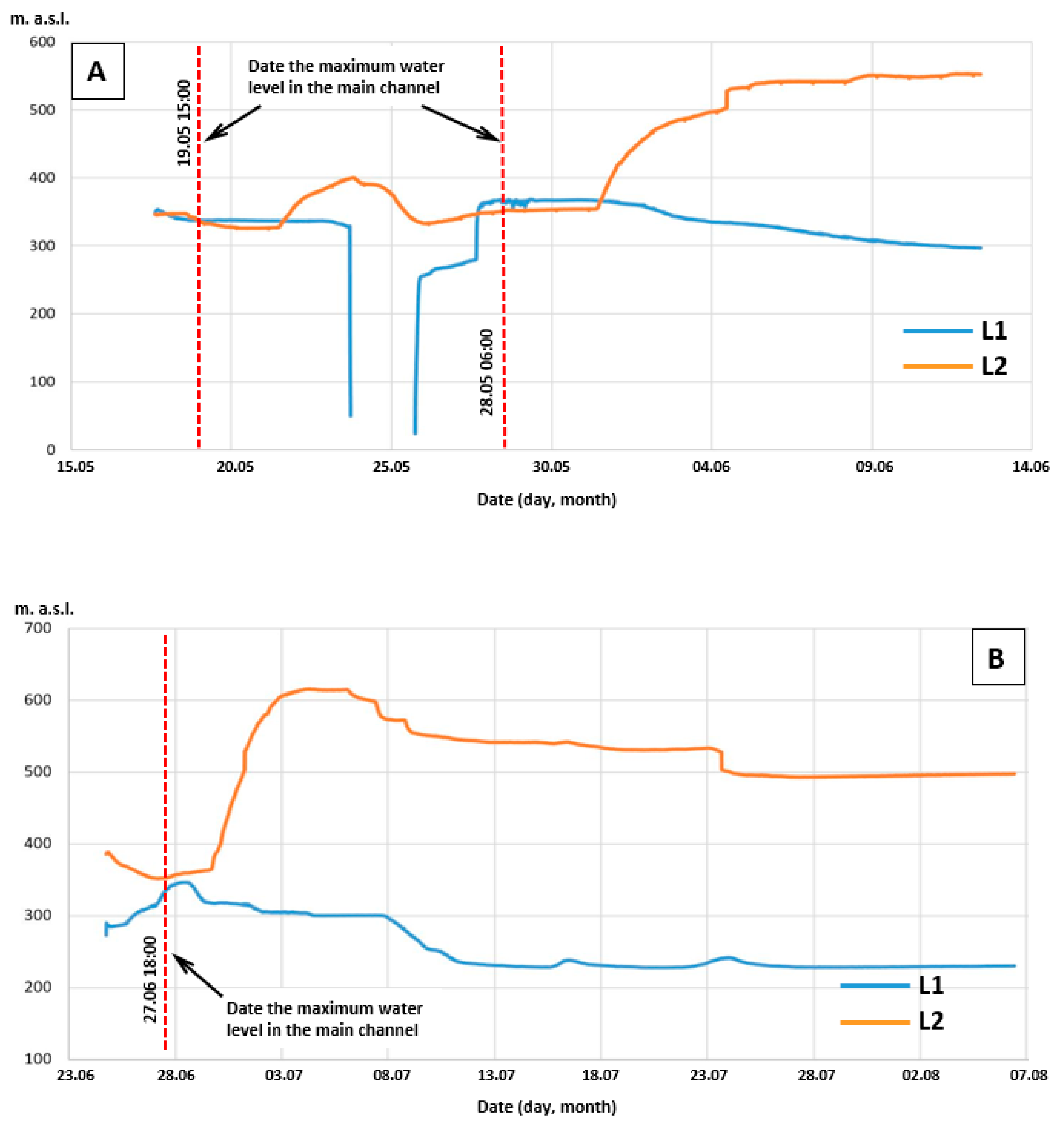
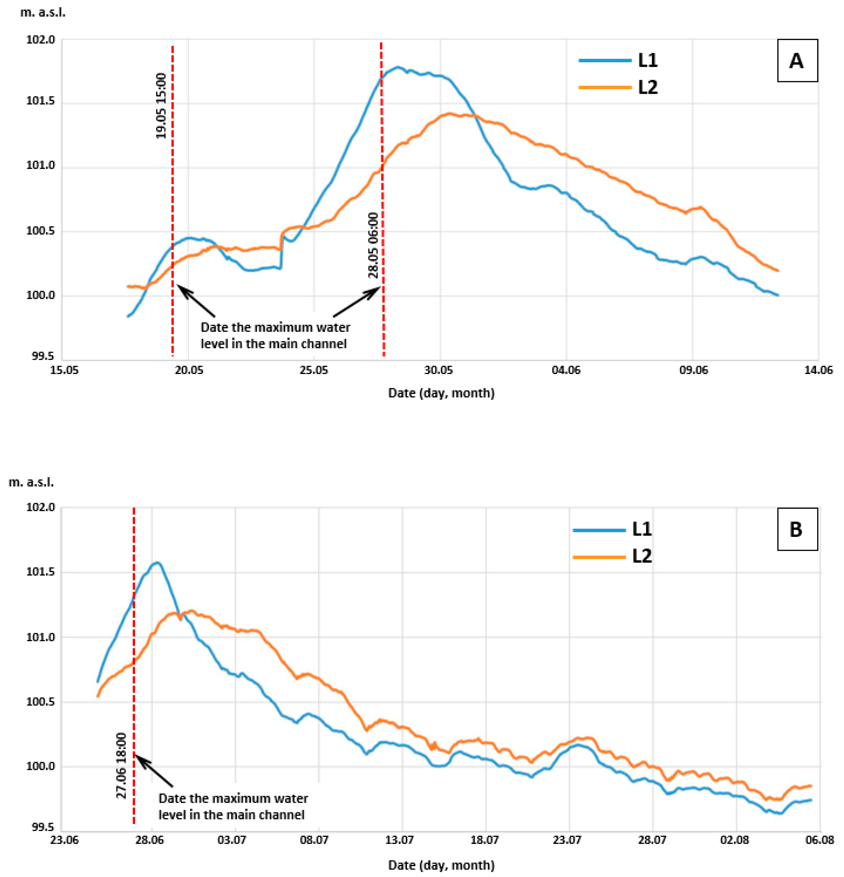
3. Results
4. Discussion
5. Summary and Conclusions
- In the zone of the untransformed terrace, the ascension of the water level between embankments causes immediate propagation of pressure in the aquifer, while the filtration process itself is considerably limited.
- Crevasse troughs constitute paths of privileged filtration, in particular in the proximal part of the floodplain, which confirms the results of the modelling studies performed earlier.
- The appearance of water with elevated conductance in the area of the crevasse proves the cyclicality of changes in flow directions, depending on the water level between embankments.
- Due to the cyclicality of changes in the directions of filtration, the natural process of soil clogging in the zone of contact between groundwater and surface waters within the range of the occurrence of crevasse troughs is considerably limited.
- The secondarily filled erosional troughs constitute pathways of intense supply for the alluvial aquifer, forming zones with preferable conditions for the location of riverbank water abstraction points of the RBF type.
- It has been confirmed that it is possible to identify such zones with the use of remote-sensing techniques, in particular LIDAR laser scanning and high-resolution satellite images.
- The research results could be of substantial importance when determining land development conditions for the floodplain. The identification of the location of the zones with preferential groundwater flow in the buried erosion channel along the flood embankment was possible based on the results, revealing increased conductivity. This made it easier to delineate the zones where the subsoil deformation initiated and to indicate the locations of favorable conditions for RBF groundwater extraction. The changes in outflow conditions, caused by climate change, provide additional justification for the careful determination of the effects of subsurface features on groundwater dynamics in the floodplain.
Author Contributions
Funding
Data Availability Statement
Conflicts of Interest
References
- Blöschl, G.; Hall, J.; Parajka, J.; Perdigão, R.A.; Merz, B.; Arheimer, B.; Živković, N. Changing climate shifts timing of European floods. Science 2017, 357, 588–590. [Google Scholar] [CrossRef] [PubMed] [Green Version]
- O’Keeffe, J.; Marcinkowski, P.; Utratna, M.; Piniewski, M.; Kardel, I.; Kundzewicz, Z.W.; Okruszko, T. Modelling climate change’s impact on the hydrology of natura 2000 Wetland habitats in the Vistula and Odra river basins in Poland. Water 2019, 11, 2191. [Google Scholar] [CrossRef] [Green Version]
- Parasiewicz, P.; King, E.L.; Webb, J.A.; Piniewski, M.; Comoglio, C.; Wolter, C.; Suska, K. The role of floods and droughts on riverine ecosystems under a changing climate. Fish. Manag. Ecol. 2019, 26, 461–473. [Google Scholar] [CrossRef]
- Piniewski, M.; Mezghani, A.; Szczesniak, M.; Kundzewicz, Z.W. Regional projections of temperature and precipitation changes: Robustness and uncertainty aspects. Meteorol. Z. 2017, 26, 223–234. [Google Scholar] [CrossRef]
- Falkowski, E. Variability of channel processes of lowland rivers in Poland and changes of thevalley floors during the Holocene. Biul. Geol. 1975, 19, 45–78. [Google Scholar]
- Falkowski, T. The importance of recognition of polygeny for the rational utilisation of river valleys in Polish Lowland. In Proceedings of the International Symposium on Engineering Geology and the Environment, Rotterdam, The Netherlands, 23–27 June 1997; pp. 107–111. [Google Scholar]
- Bujakowski, F.; Falkowski, T.; Podlasek, A. Geomorphological immaturity as a factor conditioning the dynamics of channel processes in Rządza River. Open Geosci. 2021, 13, 27–38. [Google Scholar] [CrossRef]
- Davis, W.M. The geographical cycle. Geogr. J. 1899, 14, 481–504. [Google Scholar] [CrossRef]
- Mojski, J.E. Ziemie Polskie w Czwartorzędzie. Zarys Morfogenezy; Państwowy Instytut Geologiczny: Warszawa, Poland, 2005. (In Polish) [Google Scholar]
- Lindner, L.; Marks, L. Zarys paleogemorfologii obszaru Polski podczas zlodowaceń skandynawskich. Przegląd Geol. 2005, 43, 591. [Google Scholar]
- Vandenberghe, J. The relation between climate and river processes, landforms and deposits during the Quaternary. Quat. Int. 2002, 91, 17–23. [Google Scholar] [CrossRef]
- Falkowski, E. Some Regularities of the Valley Floor Evolution of the Middle Vistula River Valley. In Evolution of the Vistula River Valley during the Last 15,000 Years; Geographical Studies; Special Issue 1; Starkel, L., Ed.; Polish Academy of Sciences Institute of Geography and Spatial Organization: Warsaw, Poland, 1982; pp. 9–20. [Google Scholar]
- Starkel, L. The reflection of hydrologic changes in fluvial environment of the temperate zone during the last 15,000 years. In Background to Paleohydrology; Gregory, K.J., Ed.; John Wiley & Sons: Chichester, UK, 1983; pp. 213–234. [Google Scholar]
- Falkowski, E. Problemy granicy między plejstocenem a holocenem w aluwiach rzek nizinnych. Przegląd Geol. 1967, 15, 186. [Google Scholar]
- Falkowski, E. Historia i prognoza rozwoju układu koryta wybranych odcinków rzek nizinnych Polski. Biul. Geol. 1971, 12, 5–121. [Google Scholar]
- Kozarski, S.; Rotnicki, K. Valley floors and changes of river channel patterns in the North Polish Plain during the Late Wurm and Holocene. Quaest. Geogr. 1977, 4, 51–93. [Google Scholar]
- Falkowski, T. The application of geomorphological analysis of the Vistula River, Poland in the evaluation of the safety of regulation structures. Acta Geol. Pol. 2007, 57, 377–390. [Google Scholar]
- Falkowska, E.; Falkowski, T. Trace metals distribution pattern in floodplain sediments of a lowland river in relation to contemporary valley bottom morphodynamics. Earth Surf. Process. Landf. 2015, 40, 876–887. [Google Scholar] [CrossRef]
- Bujakowski, F.; Falkowski, T. Hydrogeological analysis supported by remote sensing methods as a tool for assessing the safety of embankments (case study from Vistula river valley, Poland). Water 2019, 11, 266. [Google Scholar] [CrossRef] [Green Version]
- Ostrowski, P.; Falkowski, T.; Utratna-Żukowska, M. The effect of geological channel structures on floodplain morphodynamics of lowland rivers: A case study from the Bug River, Poland. CATENA 2021, 202, 105209. [Google Scholar] [CrossRef]
- Falkowski, T.; Ostrowski, P.; Bogucki, M.; Karczmarz, D. The trends in the main thalweg path of selected reaches of the Middle Vistula River, and their relationships to the geological structure of river channel zone. Open Geosci. 2018, 10, 554–564. [Google Scholar] [CrossRef]
- Ostrowski, P.; Falkowski, T. Application of Remote Sensing Methods to Study the Relief of Lowland River Valleys with a Complex Geological Structure—A Case Study of the Bug River. Water 2020, 12, 487. [Google Scholar] [CrossRef] [Green Version]
- Podlasek, A.; Bujakowski, F.; Koda, E. The spread of nitrogen compounds in an active groundwater exchange zone within a valuable natural ecosystem. Ecol. Eng. 2020, 146, 105746. [Google Scholar] [CrossRef]
- Bujakowski, F. Morfogenetyczne Kryteria Identyfikacji Zróżnicowania Filtracji w Warstwie Aluwialnej Na Przykładzie Doliny Środkowej Wisły. Ph.D. Thesis, Warsaw University of Life Sciences, Warsaw, Poland, 2015. (In Polish). [Google Scholar]
- Sieczka, A.; Bujakowski, F.; Falkowski, T.; Koda, E. Morphogenesis of a floodplain as a criterion for assessing the susceptibility to water pollution in an agriculturally rich valley of a lowland river. Water 2018, 10, 399. [Google Scholar] [CrossRef] [Green Version]
- The European Union. Directive 2007/60/EC of the European Parliament and of the Council of 23 October 2007 on the Assessment and Management of Flood Risks, Which Entered into Force on November 26, 2007; The European Union: Brussels, Belgium, 2007. [Google Scholar]
- Main Office of Geodesy and Cartography. Available online: http://www.gugik.gov.pl/projekty/isok/produkty (accessed on 19 January 2022).
- Viero, D.P.; D’Alpaos, A.; Carniello, L.; Defina, A. Mathematical modeling of flooding due to river bank failure. Adv. Water Resour. 2013, 59, 82–94. [Google Scholar] [CrossRef]
- Wierzbicki, G.; Ostrowski, P.; Mazgajski, M.; Bujakowski, F. Using VHR multispectral remote sensing and LIDAR data to determine the geomorphological effects of overbank flow on a floodplain (the Vistula River, Poland). Geomorphology 2013, 183, 73–81. [Google Scholar] [CrossRef]
- Wierzbicki, G.; Ostrowski, P.; Falkowski, T.; Mazgajski, M. Geological setting control of flood dynamics in lowland rivers (Poland). Sci. Total Environ. 2018, 636, 367–382. [Google Scholar] [CrossRef] [PubMed]
- Cellone, F.A.; Borzi, G.; Santucci, L.; Tanjal, C.; Villalba, E.; Carol, E. Water Dynamics in a Coastal Wetland in the “Parque Costero del Sur” Biosphere Reserve, Argentina. Wetlands 2021, 41, 83. [Google Scholar] [CrossRef]
- Nixdorf, E.; Trauth, N. Evaluating the reliability of time series analysis to estimate variable riparian travel times by numerical groundwater modelling. Hydrol. Process. 2018, 32, 408–420. [Google Scholar] [CrossRef]
- Coluccio, K.; Morgan, L.K. A review of methods for measuring groundwater–surface water exchange in braided rivers. Hydrol. Earth Syst. Sci. 2019, 23, 4397–4417. [Google Scholar] [CrossRef]
- Karabon, J. Morfogenetyczna działalność wód wezbraniowych związana z zatorami lodowymi w dolinie Wisły Środkowej. Przegląd Geol. 1980, 28, 512–515. [Google Scholar]
- Starkel, L. Historia Doliny Wisły: Od Ostatniego Zlodowacenia Do Dziś Evolution of the Vistula River Valley since the Last Glaciation till Present; Polish Academy of Sciences Institute of Geography and Spatial Organization: Warsaw, Poland, 2001. [Google Scholar]
- Starkel, L. Change in the frequency of extreme events as the indicator of climatic change in the Holocene (in fluvial systems). Quat. Int. 2002, 91, 25–32. [Google Scholar] [CrossRef] [Green Version]
- Myślińska, E. Kryteria oceny inżyniersko-geologicznych właściwości mad. Kwart. Geol. 1984, 28, 143–162. [Google Scholar]
- National Geoportal. Available online: https://mapy.geoportal.gov.pl (accessed on 19 January 2022).
- Jung, M.; Burt, T.P.; Bates, P.D. Toward a conceptual model of floodplain water table response. Water Resour. Res. 2004, 40, W12409. [Google Scholar] [CrossRef]
- Fleckenstein, J.H.; Krause, S.; Hannah, D.M.; Boano, F. Groundwater-surface water interactions: New methods and models to improve understanding of processes and dynamics. Adv. Water Resour. 2010, 33, 1291–1295. [Google Scholar] [CrossRef]
- Shankar, V.; Eckert, P.; Ojha, C.; König, C.M. Transient three-dimensional modeling of riverbank filtration at Grind well field, Germany. Hydrogeol. J. 2009, 17, 321–326. [Google Scholar] [CrossRef]
- Rucker, D.F.; Noonan, G.E.; Greenwood, W.J. Electrical resistivity in support of geological mapping along the Panama Canal. Eng. Geol. 2011, 117, 121–133. [Google Scholar] [CrossRef]
- Wang, P.; Pozdniakov, S.P.; Shestakov, V.M. Optimum experimental design of a monitoring network for parameter identification at riverbank well fields. J. Hydrol. 2015, 523, 531–541. [Google Scholar] [CrossRef]
- Ascott, M.J.; Lapworth, D.J.; Gooddy, D.C.; Sage, R.C.; Karapanos, I. Impacts of extreme flooding on riverbank filtration water quality. Sci. Total Environ. 2016, 554, 89–101. [Google Scholar] [CrossRef] [PubMed] [Green Version]
- Dimkic, M.; Brauch, H.J.; Kavanaugh, M. (Eds.) Groundwater Management in Large River Basins; Iwa Publishing: London, UK, 2008. [Google Scholar]
- Sieczka, A.; Bujakowski, F.; Koda, E. Modelling groundwater flow and nitrate transport: A case study of an area used for precision agriculture in the middle part of the Vistula River valley, Poland. Geologos 2018, 24, 225–235. [Google Scholar] [CrossRef] [Green Version]
- Matusiak, M.; Dragon, K.; Gorski, J.; Kruc-Fijałkowska, R.; Przybylek, J. Surface water and groundwater interaction at long-term exploited riverbank filtration site based on groundwater flow modelling (Mosina-Krajkowo, Poland). J. Hydrol. Reg. Stud. 2021, 37, 100882. [Google Scholar] [CrossRef]
- Goldschneider, A.A.; Haralampides, K.A.; MacQuarrie, K.T. River sediment and flow characteristics near a bank filtration water supply: Implications for riverbed clogging. J. Hydrol. 2007, 344, 55–69. [Google Scholar] [CrossRef]
- Shen, M.; Chui, T.F.M. Characterizing the responses of local floods to changing climate in three different hydroclimatic regions across the United States. Adv. Water Resour. 2021, 150, 103885. [Google Scholar] [CrossRef]
- Allmendinger, R.W.; Karabinos, P. Illuminating geology in areas of limited exposure using texture shading of lidar digital terrain models. Geosphere 2022. [Google Scholar] [CrossRef]
- Wierzbicki, G.; Ostrowski, P.; Bartold, P.; Bujakowski, F.; Falkowski, T.; Osiński, P. Urban geomorphology of the Vistula River valley in Warsaw. J. Maps 2021, 17, 170–185. [Google Scholar] [CrossRef]


Publisher’s Note: MDPI stays neutral with regard to jurisdictional claims in published maps and institutional affiliations. |
© 2022 by the authors. Licensee MDPI, Basel, Switzerland. This article is an open access article distributed under the terms and conditions of the Creative Commons Attribution (CC BY) license (https://creativecommons.org/licenses/by/4.0/).
Share and Cite
Bujakowski, F.; Falkowski, T.; Podlasek, A.; Ostrowski, P. Real-Time Groundwater Dynamics Verification in the Embankment’s Substrate during the Transition of a Flood Wave. Water 2022, 14, 3986. https://doi.org/10.3390/w14243986
Bujakowski F, Falkowski T, Podlasek A, Ostrowski P. Real-Time Groundwater Dynamics Verification in the Embankment’s Substrate during the Transition of a Flood Wave. Water. 2022; 14(24):3986. https://doi.org/10.3390/w14243986
Chicago/Turabian StyleBujakowski, Filip, Tomasz Falkowski, Anna Podlasek, and Piotr Ostrowski. 2022. "Real-Time Groundwater Dynamics Verification in the Embankment’s Substrate during the Transition of a Flood Wave" Water 14, no. 24: 3986. https://doi.org/10.3390/w14243986