
Antarctic Bottom Water Jets Flowing from the Vema Channel


Abstract
1. Introduction
2. Data
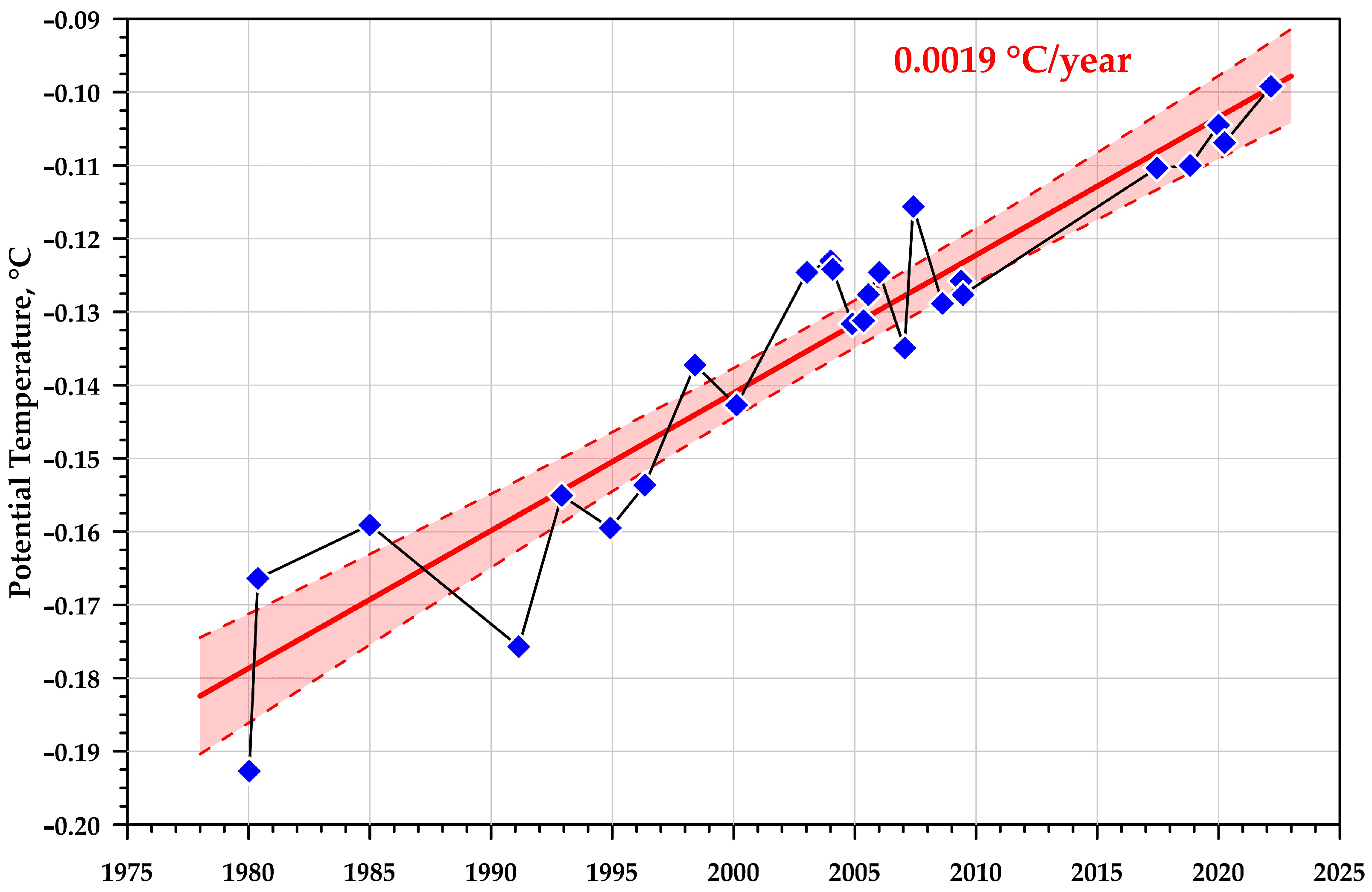
3. Results
Author Contributions
Funding
Institutional Review Board Statement
Informed Consent Statement
Data Availability Statement
Conflicts of Interest
References
- Zenk, W.; Speer, K.G.; Hogg, N.G. Bathymetry at the Vema Sill. Deep Sea Res. 1993, 40, 1925–1933. [Google Scholar] [CrossRef][Green Version]
- Johnson, D.A.; McDowel, S.E.; Sullivan, L.G.; Biscaye, P.E. Abyssal hydrography, nephelometry, currents, and benthic boundary layer structure in the Vema Channel. J. Geophys. Res. 1976, 81, 5771–5786. [Google Scholar] [CrossRef]
- Morozov, E.G.; Tarakanov, R.Y.; Frey, D.I. Bottom Gravity Currents and Overflows in Deep Channels of the Atlantic Observations, Analysis, and Modeling; Springer: Dordrecht, The Netherlands, 2021; p. 483. [Google Scholar] [CrossRef]
- Speer, K.G.; Zenk, W. The flow of Antarctic Bottom water into the Brazil Basin. J. Phys. Oceanogr. 1993, 23, 2667–2682. [Google Scholar] [CrossRef]
- Jungclaus, J.; Vanicek, M. Frictionally modified flow in a deep ocean channel: Application to the Vema Channel. J. Geophys. Res. Ocean. 1999, 104, 21123–21136. [Google Scholar] [CrossRef]
- Zenk, W.; Hogg, N.G. Warming trend in Antarctic Bottom Water flowing into the Brazil Basin. Deep Sea Res. 1996, 43, 1461–1473. [Google Scholar] [CrossRef]
- Zenk, W.; Morozov, E.G. Decadal warming of the coldest Antarctic Bottom Water flow through the Vema Channel. Geophys. Res. Lett. 2007, 34, L14607. [Google Scholar] [CrossRef]
- Campos, E.J.D.; van Caspel, M.C.; Zenk, W.; Morozov, E.G.; Frey, D.I.; Piola, A.R.; Meinen, C.S.; Sato, O.T.; Perez, R.C.; Dong, S. Warming trend in the abyssal flow through the Vema Channel in the South Atlantic. Geophys. Res. Lett. 2021, 48, e2021GL094709. [Google Scholar] [CrossRef]
- Smythe-Wright, D.; Boswell, S. Abyssal circulation in the Argentine Basin. J. Geophys. Res. Ocean. 1998, 103, 15845–15851. [Google Scholar] [CrossRef]
- Tarakanov, R.Y.; Morozov, E.G. Flow of Antarctic Bottom Water at the output of the Vema Channel. Oceanology 2015, 55, 153–161. [Google Scholar] [CrossRef]
- Tarakanov, R.Y.; Morozov, E.G.; Frey, D.I. Hydraulic continuation of the abyssal flow from the Vema Channel in the southwestern part of the Brazil Basin. J. Geophys. Res. 2020, 125, e2020JC016232. [Google Scholar] [CrossRef]
- Morozov, E.G.; Frey, D.I.; Tarakanov, R.Y. Flow of Antarctic Bottom Water from the Vema Channel. Geosci. Lett. 2020, 7, 16. [Google Scholar] [CrossRef]
- Frey, D.I.; Morozov, E.G.; Fomin, V.V.; Diansky, N.A.; Tarakanov, R.Y. Regional modeling of Antarctic Bottom Water flows in the key passages of the Atlantic. J. Geophys. Res. Ocean. 2019, 124, 8414–8428. [Google Scholar] [CrossRef]
- Frey, D.; Borisov, D.; Fomin, V.; Morozov, E.; Levchenko, O. Modeling of bottom currents for estimating their erosional-depositional potential in the Southwest Atlantic. J. Mar. Syst. 2022, 230, 103736. [Google Scholar] [CrossRef]
- Hogg, N.; Siedler, G.; Zenk, W. Circulation and variability at the Southern Boundary of the Brazil Basin. J. Phys. Oceanogr. 1999, 29, 145–157. [Google Scholar] [CrossRef]
- Egbert, G.D.; Erofeeva, S. Efficient inverse modeling of barotropic ocean tides. J. Atmos. Ocean. Tech. 2002, 19, 183–204. [Google Scholar] [CrossRef]
- Zenk, W. Abyssal and contour currents. In Developments in Sedimentology, Contourites; Rebesco, M., Camerlenghi, A., Eds.; Elsevier: Amsterdam, The Netherlands, 2008; Volume 60, pp. 37–57. [Google Scholar]
- Morozov, E.G.; Demidov, A.N.; Tarakanov, R.Y.; Zenk, W. Abyssal Channels in the Atlantic Ocean: Water Structure and Flows; Springer: Dordrecht, The Netherlands, 2010; p. 266. [Google Scholar] [CrossRef]
- Sandoval, F.J.; Weatherly, G.L. Evolution of the deep western boundary current of Antarctic Bottom Water in the Brazil Basin. J. Phys. Oceanogr. 2001, 31, 1440–1460. [Google Scholar] [CrossRef]


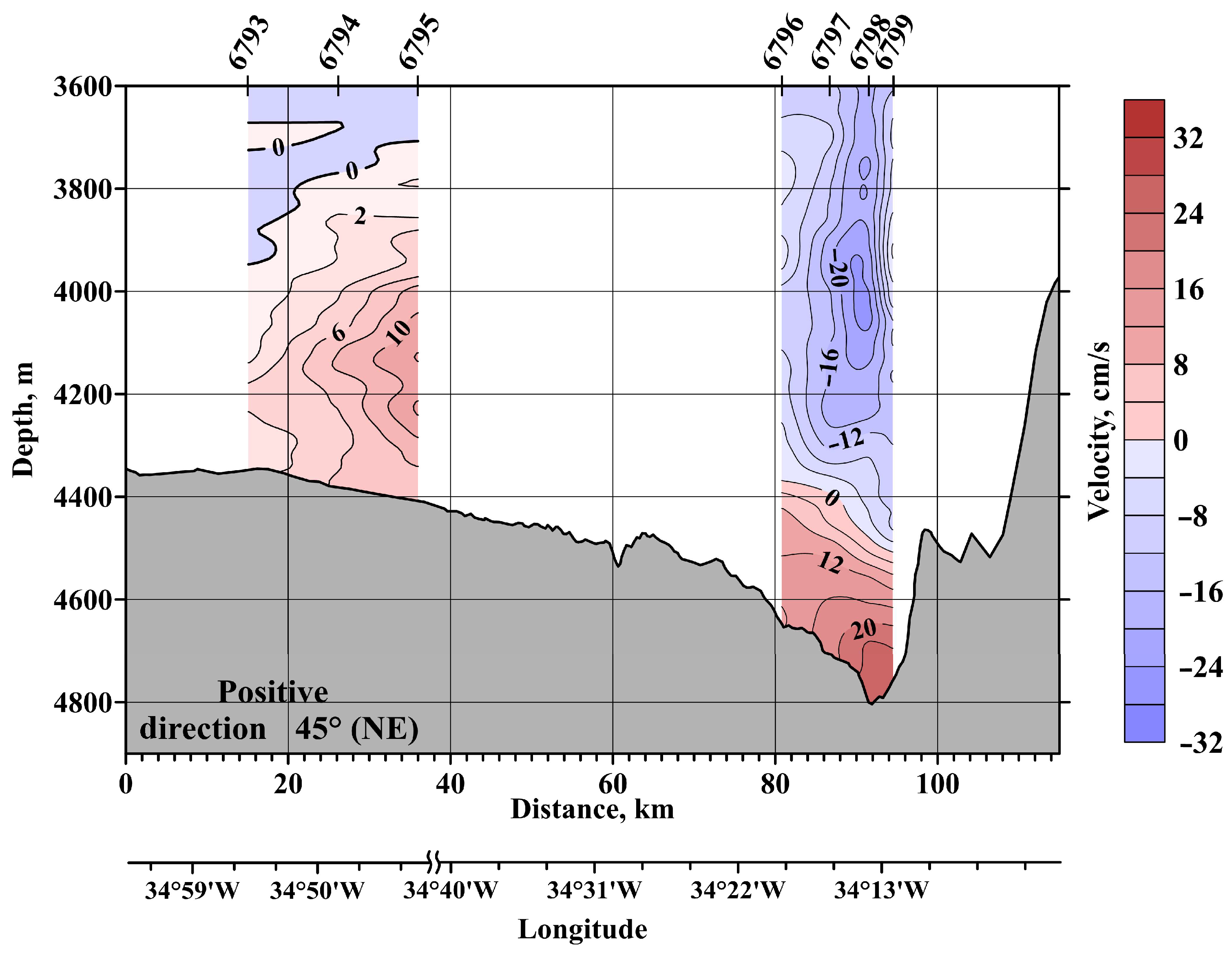
 ) show stations in 2019. Red circles show stations in 2020. Yellow arrows show directions of currents and their speed (vectors). Deep water areas are shown in blue, especially the canyon at 24°40′ S. Two thin magenta lines show the previously analyzed AABW flows from the deep bottom of the channel. The thick magenta line shows the flow of the branch that initially was found above the western wall. The brown line shows the possible pathway of the shallowest jet (~4600–4700 m), which is plotted using only the CTD data from 1994 and 2003 [updated from [12]]. The existence of this flow was confirmed in 2022.
) show stations in 2019. Red circles show stations in 2020. Yellow arrows show directions of currents and their speed (vectors). Deep water areas are shown in blue, especially the canyon at 24°40′ S. Two thin magenta lines show the previously analyzed AABW flows from the deep bottom of the channel. The thick magenta line shows the flow of the branch that initially was found above the western wall. The brown line shows the possible pathway of the shallowest jet (~4600–4700 m), which is plotted using only the CTD data from 1994 and 2003 [updated from [12]]. The existence of this flow was confirmed in 2022.
) show stations in 2019. Red circles show stations in 2020. Yellow arrows show directions of currents and their speed (vectors). Deep water areas are shown in blue, especially the canyon at 24°40′ S. Two thin magenta lines show the previously analyzed AABW flows from the deep bottom of the channel. The thick magenta line shows the flow of the branch that initially was found above the western wall. The brown line shows the possible pathway of the shallowest jet (~4600–4700 m), which is plotted using only the CTD data from 1994 and 2003 [updated from [12]]. The existence of this flow was confirmed in 2022.


| Stations | Date | Coordinates |
|---|---|---|
| R/V Maurice Ewing (only CTD) | ||
| 81 | 02.02.1994 | 27°21.1′ S, 36°36.7′ W |
| 82 | 02.02.1994 | 26°58.6′ S, 36°16.1ʹ W |
| 83 | 02.02.1994 | 26°34.6ʹ S, 35°55.7ʹ W |
| 84 | 02.02.1994 | 26°11.2ʹ S, 35°34.2ʹ W |
| 85 | 03.02.1994 | 25°47.8ʹ S, 35°14.0ʹ W |
| 86 | 03.02.1994 | 25°24.4ʹ S, 34°53.4ʹ W |
| 87 | 03.02.1994 | 25°01.1ʹ S, 34°32.7ʹ W |
| 88 | 03.02.1994 | 24°37.6ʹ S, 34°11.9ʹ W |
| 89 | 04.02.1994 | 24°14.2ʹ S, 33°51.8ʹ W |
| 90 | 04.02.1994 | 23°50.8ʹ S, 33°30.9ʹ W |
| 91 | 04.02.1994 | 23°27.5ʹ S, 33°10.3ʹ W |
| 92 | 04.02.1994 | 23°04.0ʹ S, 32°49.4ʹ W |
| R/V Akademik Sergey Vavilov (only CTD) | ||
| 1441 | 02.11.2003 | 26°00.0′ S, 35°15.0′ W |
| 1442 | 02.11.2003 | 26°14.9′ S, 34°53.0′ W |
| 1443 | 02.11.2003 | 26°27.5′ S, 34°35.8′ W |
| 1444 | 03.11.2003 | 26°40.9′ S, 34°15.4′ W |
| 1445 | 03.11.2003 | 26°43.2′ S, 34°12.1′ W |
| 1446 | 03.11.2003 | 26°44.4′ S, 34°10.8′ W |
| 1454 | 09.11.2003 | 27°05.5′ S, 35°54.7′ W |
| R/V Akademik Ioffe | ||
| 2079 | 18.04.2009 | 26°42.9′ S, 34°12.2′ W |
| 2080 | 18.04.2009 | 26°01.9′ S, 33°58.0′ W |
| 2437 | 06.11.2010 | 26°39.9′ S, 34°16.8′ W |
| 2438 | 06.11.2010 | 26°42.2′ S, 34°13.8′ W |
| 2439 | 06.11.2010 | 26°43.4′ S, 34°12.1′ W |
| R/V Akademik Sergey Vavilov | ||
| 2494 | 05.11.2012 | 26°36.8′ S, 33°59.3′ W |
| 2495 | 05.11.2012 | 26°35.9′ S, 34°10.2′ W |
| 2496 | 06.11.2012 | 26°31.1′ S, 34°03.3′ W |
| 2497 | 06.11.2012 | 26°35.8′ S, 33°51.7′ W |
| 2521 | 18.10.2013 | 26°20.5′ S, 32°00.1′ W |
| 2522 | 18.10.2013 | 26°27.7′ S, 32°53.1′ W |
| 2523 | 18.10.2013 | 26°23.0′ S, 32°53.1′ W |
| 2525 | 19.10.2013 | 26°18.6′ S, 33°11.5′ W |
| 2526 | 20.10.2013 | 26°35.7′ S, 33°51.6′ W |
| 2527 | 20.10.2013 | 26°37.3′ S, 33°39.6′ W |
| 2710 | 22.10.2018 | 25°34.1′ S, 33°29.5′ W |
| 2711 | 22.10.2018 | 25°34.0′ S, 33°31.1′ W |
| 2712 | 22.10.2018 | 25°34.0′ S, 33°27.4′ W |
| 2713 | 22.10.2018 | 25°34.0′ S, 33°32.6′ W |
| 2714 | 23.10.2018 | 25°33.6′ S, 33°48.3′ W |
| 2716 | 23.10.2018 | 26°00.0′ S, 33°32.6′ W |
| R/V Akademik Mstislav Keldysh | ||
| 6563 | 30.12.2019 | 24°10.1′ S, 33°37.9′ W |
| 6564 | 30.12.2019 | 25°34.0′ S, 34°21.2′ W |
| 6565 | 31.12.2019 | 25°33.9′ S, 34°30.0′ W |
| 6566 | 31.12.2019 | 26°20.0′ S, 34°29.9′ W |
| 6567 | 31.12.2019 | 26°20.0′ S, 34°40.0′ W |
| 6793 | 03.04.2020 | 26°25.0′ S, 34°54.6′ W |
| 6794 | 03.04.2020 | 26°25.0′ S, 34°48.0′ W |
| 6795 | 03.04.2020 | 26°25.0′ S, 34°41.9′ W |
| 6796 | 06.04.2020 | 26°39.2′ S, 34°16.8′ W |
| 6797 | 06.04.2020 | 26°41.4′ S, 34°14.2′ W |
| 6798 | 06.04.2020 | 26°43.1′ S, 34°12.1′ W |
| 6799 | 06.04.2020 | 26°44.4′ S, 34°10.8′ W |
| 6800 | 07.04.2020 | 25°56.4′ S, 33°30.0′ W |
| 6801 | 07.04.2020 | 25°13.0′ S, 33°51.0′ W |
| 6802 | 07.04.2020 | 24°00.0′ S, 33°40.0′ W |
| 6803 | 07.04.2020 | 24°55.1′ S, 33°40.0′ W |
| 6804 | 07.04.2020 | 24°48.0′ S, 33°40.0′ W |
| 6805 | 08.04.2020 | 24°42.0′ S, 33°40.0′ W |
| 6806 | 08.04.2020 | 25°06.0′ S, 34°00.0′ W |
| 6807 | 08.04.2020 | 24°59.0′ S, 34°09.0′ W |
| 6808 | 08.04.2020 | 24°52.0′ S, 34°17.9′ W |
| 6809 | 08.04.2020 | 24°45.0′ S, 34°27.0′ W |
| 7411 | 02.03.2022 | 26° 54.1 S, 34° 18.8′ W |
| 7412 | 03.03.2022 | 26° 44.3 S, 34° 10.1′ W |
| 7413 | 03.03.2022 | 26° 43.2 S, 34° 12.0′ W |
| 7414 | 03.03.2022 | 26° 41.4 S, 34° 14.3′ W |
| 7415 | 03.03.2022 | 26° 39.0 S, 34° 16.7′ W |
| 7417 | 04.03.2022 | 26° 34.1 S, 34° 22.7′ W |
| 7418 | 04.03.2022 | 26° 28.7 S, 34° 30.0′ W |
| 7419 | 04.03.2022 | 26° 24.0 S, 34° 36.0′ W |
| 7420 | 04.03.2022 | 26° 17.4 S, 34° 44.5′ W |
| 7422 | 05.03.2022 | 26° 10.8 S, 34° 52.0′ W |
| 7423 | 05.03.2022 | 26° 04.2 S, 35° 00.0′ W |
| 7424 | 05.03.2022 | 25° 58.8 S, 35° 06.0′ W |
| 7425 | 05.03.2022 | 25° 54.0 S, 35° 12.0′ W |
| 7426 | 05.03.2022 | 25° 49.2 S, 35° 17.0′ W |
Publisher’s Note: MDPI stays neutral with regard to jurisdictional claims in published maps and institutional affiliations. |
© 2022 by the authors. Licensee MDPI, Basel, Switzerland. This article is an open access article distributed under the terms and conditions of the Creative Commons Attribution (CC BY) license (https://creativecommons.org/licenses/by/4.0/).
Share and Cite
Morozov, E.G.; Zuev, O.A.; Frey, D.I.; Krechik, V.A. Antarctic Bottom Water Jets Flowing from the Vema Channel. Water 2022, 14, 3438. https://doi.org/10.3390/w14213438
Morozov EG, Zuev OA, Frey DI, Krechik VA. Antarctic Bottom Water Jets Flowing from the Vema Channel. Water. 2022; 14(21):3438. https://doi.org/10.3390/w14213438
Chicago/Turabian StyleMorozov, Eugene G., Oleg A. Zuev, Dmitry I. Frey, and Viktor A. Krechik. 2022. "Antarctic Bottom Water Jets Flowing from the Vema Channel" Water 14, no. 21: 3438. https://doi.org/10.3390/w14213438
APA StyleMorozov, E. G., Zuev, O. A., Frey, D. I., & Krechik, V. A. (2022). Antarctic Bottom Water Jets Flowing from the Vema Channel. Water, 14(21), 3438. https://doi.org/10.3390/w14213438