
Streambed Median Grain Size (D50) across the Contiguous U.S.

 ,
, 
Abstract
1. Introduction
2. Data
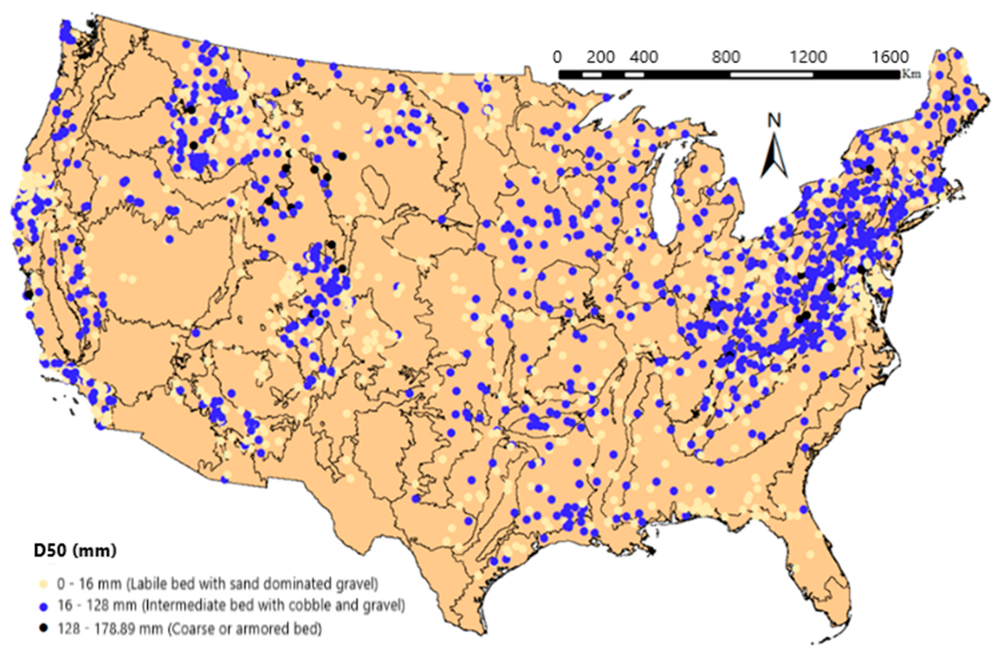
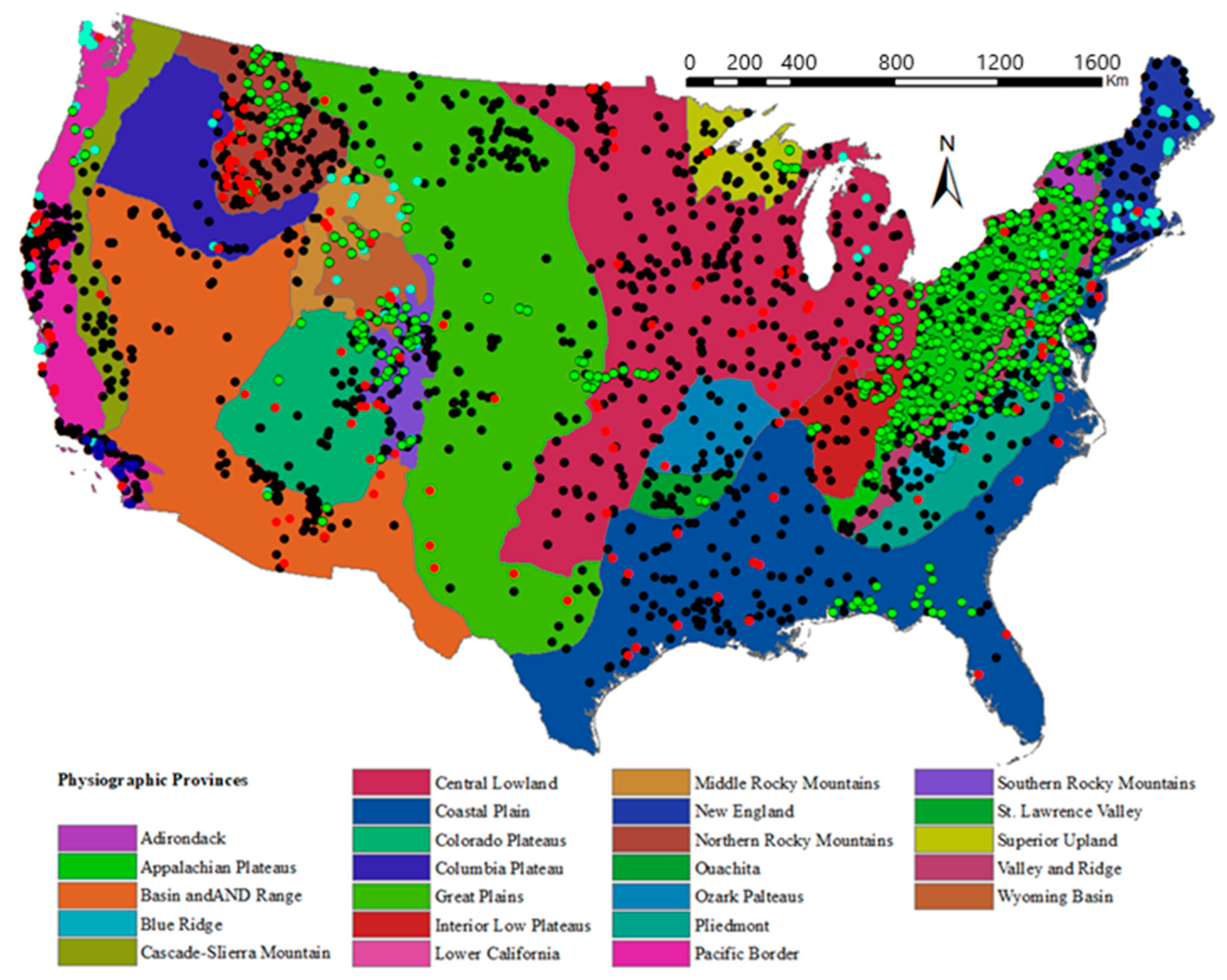
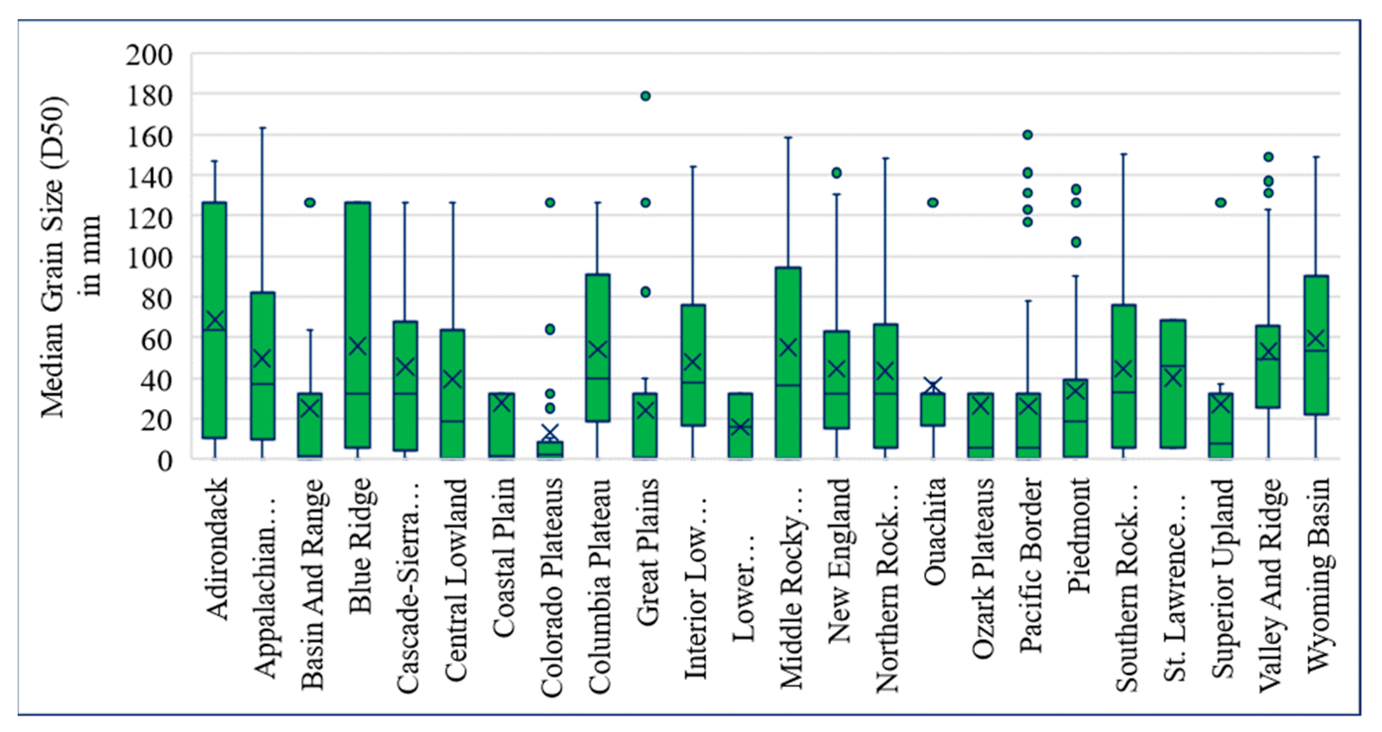
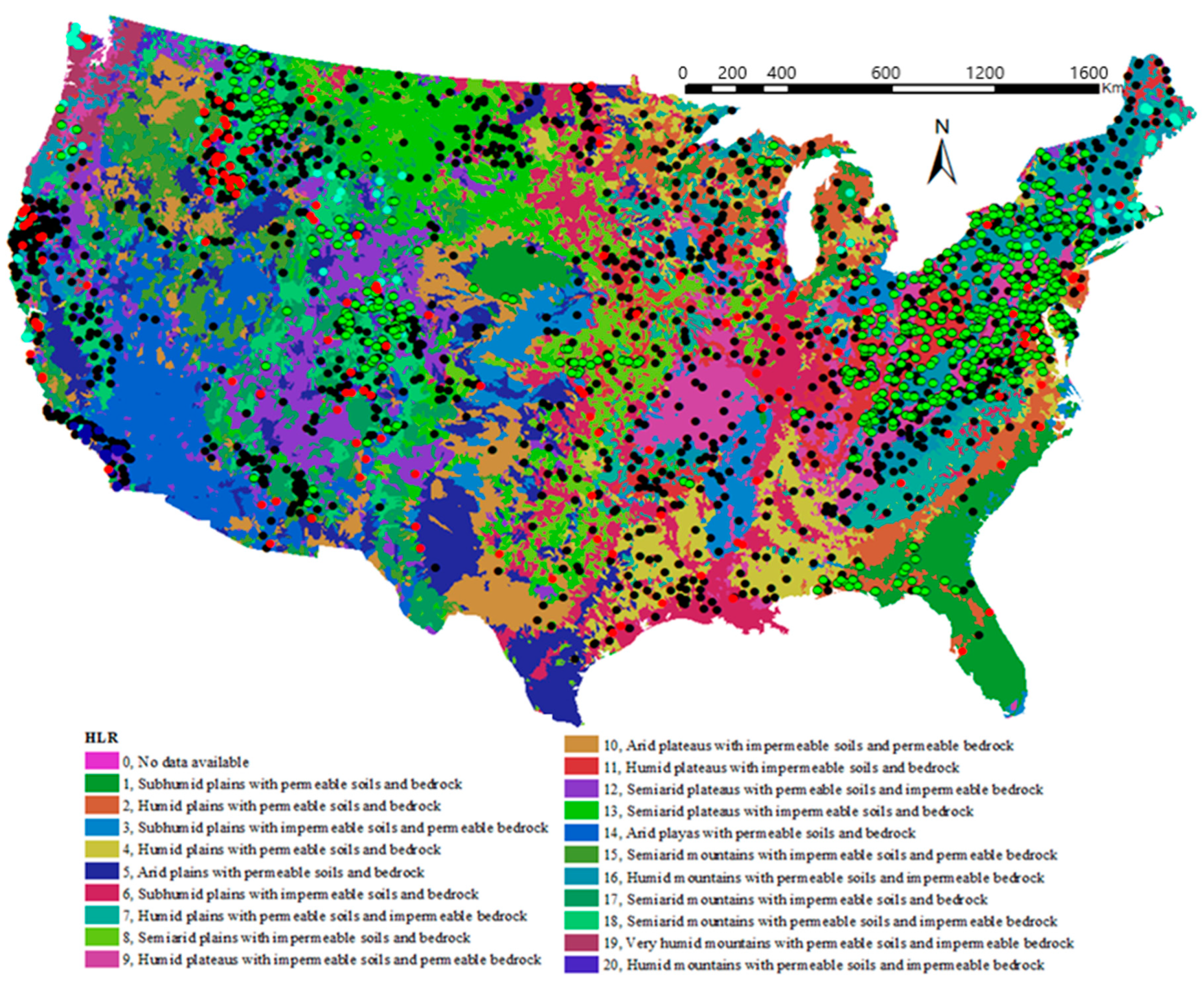
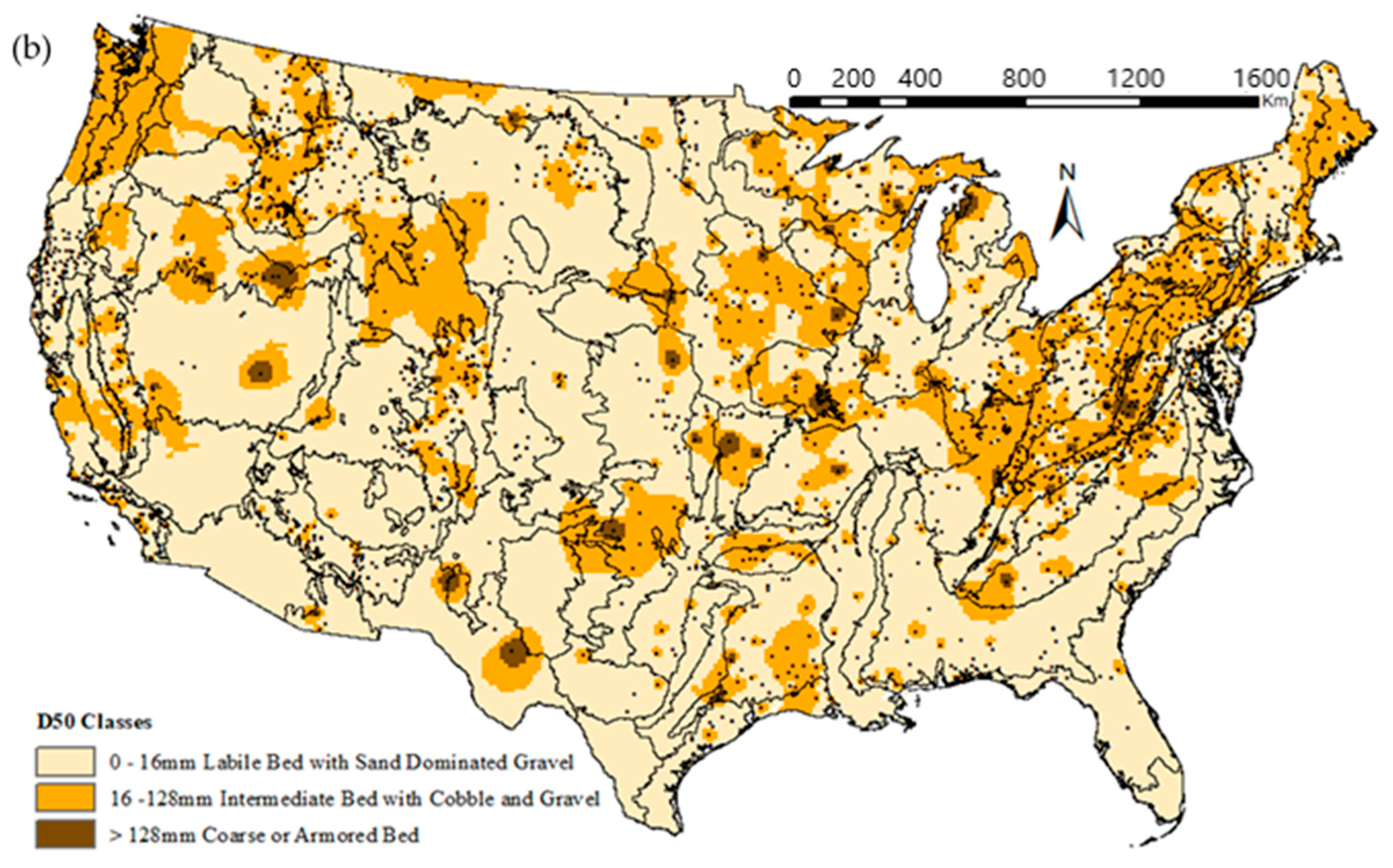
3. Distribution of D50 by Regions
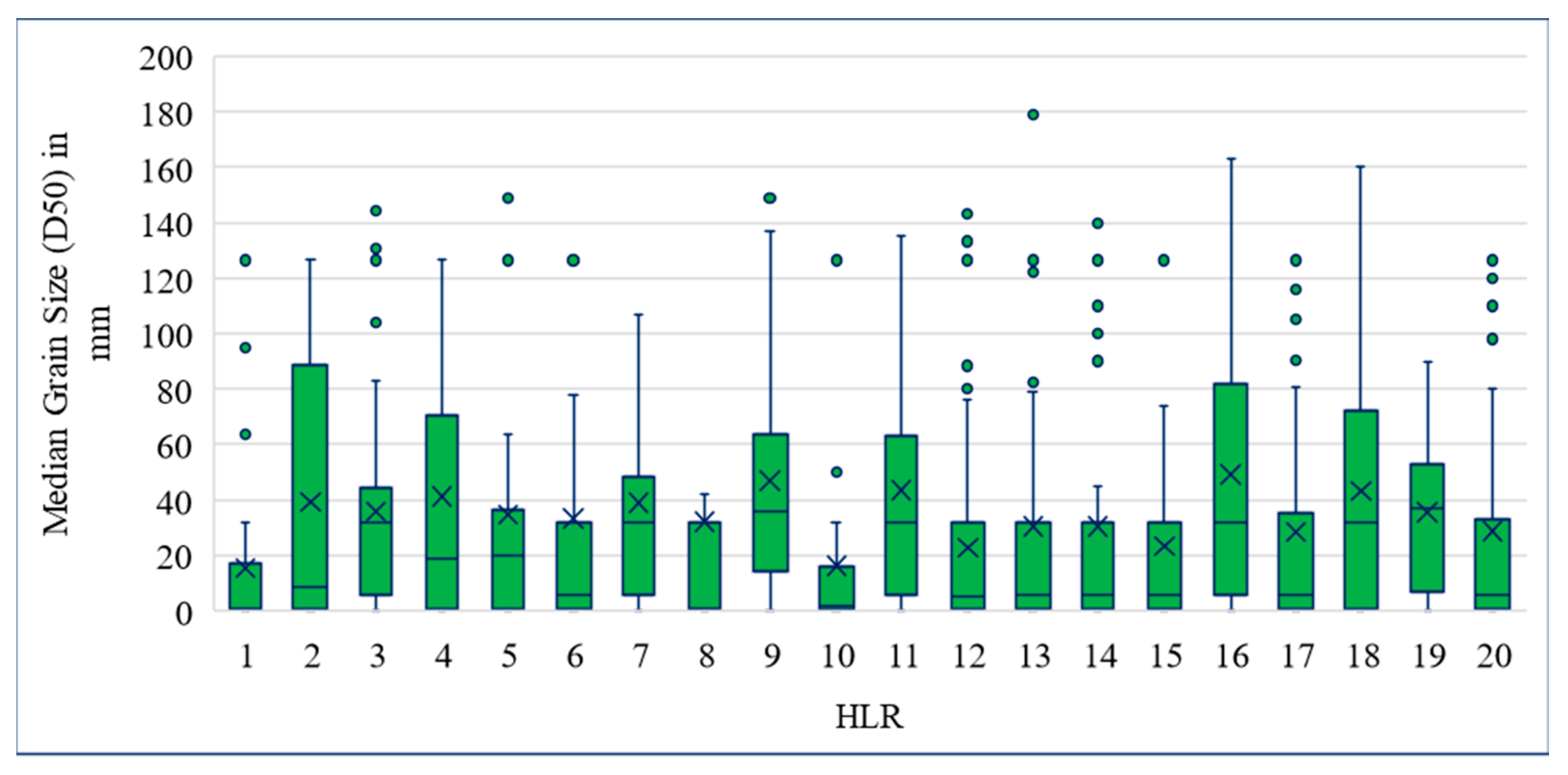
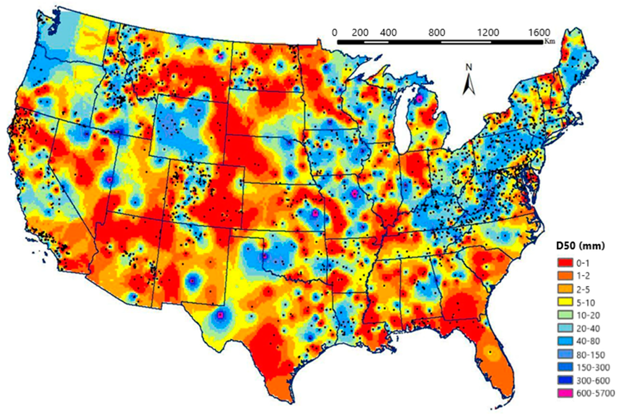
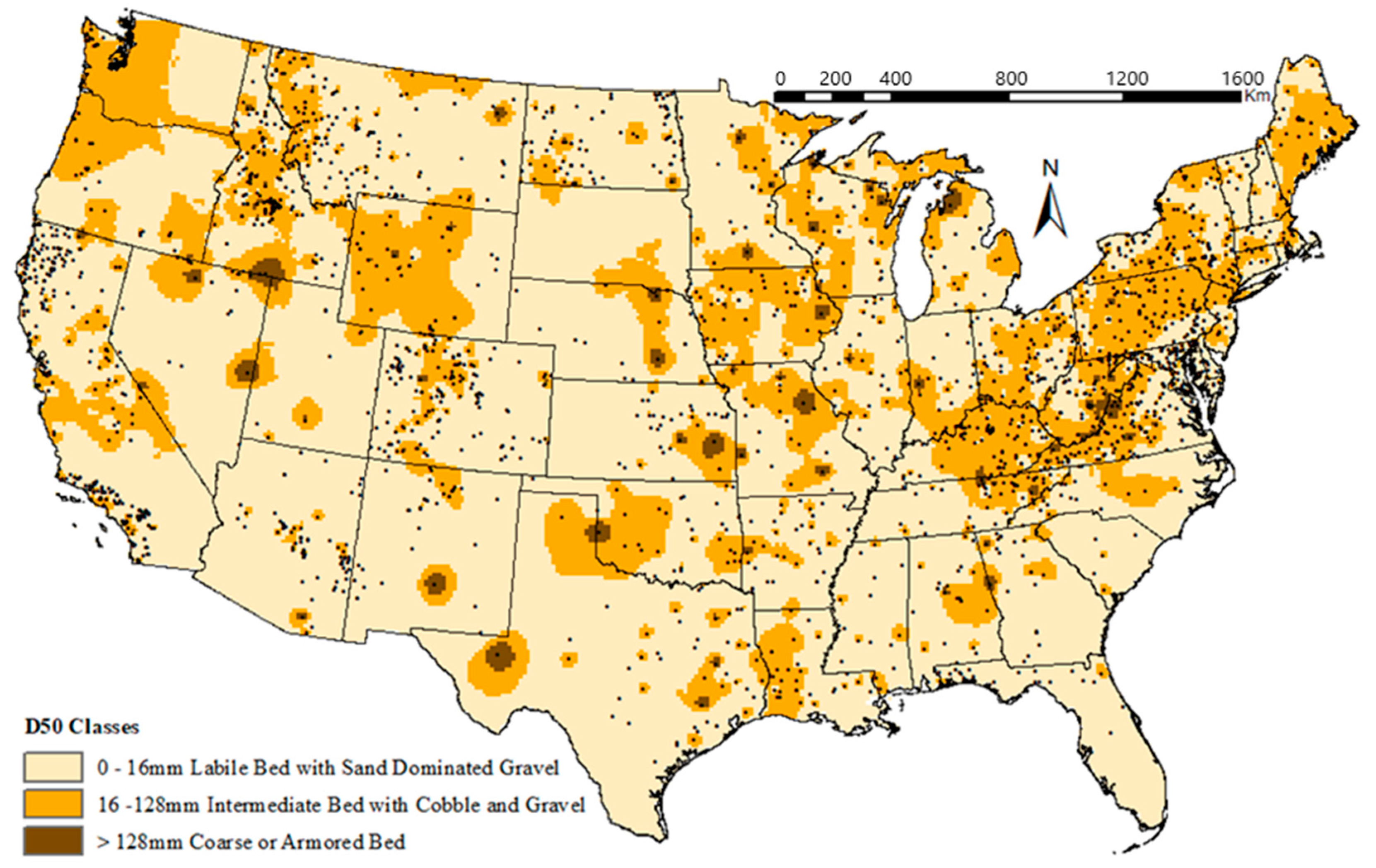
4. Analysis of D50 Data over the Contiguous U.S.
5. Summary and Conclusions
Supplementary Materials
Author Contributions
Funding
Data Availability Statement
Conflicts of Interest
Appendix A

| Level III Ecoregion | No. of Points | Min | Q1 | Median | Q3 | Max |
|---|---|---|---|---|---|---|
| Acadian Plains and Hills | 37 | 5.24062 | 18.77 | 39.39 | 50.82 | 87.90 |
| Arizona/New Mexico Mountains | 46 | 0.00775 | 0.35 | 0.35 | 32.00 | 126.49 |
| Arizona/New Mexico Plateau | 16 | 0.00775 | 0.35 | 0.35 | 12.66 | 32.00 |
| Arkansas Valley | 4 | 0.34641 | 24.09 | 32.00 | 32.00 | 32.00 |
| Atlantic Coastal Pine Barrens | 6 | 5.65690 | 32.00 | 32.00 | 126.49 | 126.49 |
| Blue Mountains | 5 | 0.34641 | 24.09 | 43.00 | 72.12 | 126.49 |
| Blue Ridge | 22 | 0.00775 | 5.66 | 32.00 | 126.49 | 126.49 |
| Boston Mountains | 6 | 0.00775 | 1.42 | 5.66 | 5.66 | 32.00 |
| Canadian Rockies | 11 | 0.00775 | 3.00 | 5.66 | 62.00 | 126.49 |
| Cascades | 7 | 0.00775 | 0.35 | 16.17 | 70.50 | 90.00 |
| Central Appalachians | 50 | 0.00775 | 29.00 | 67.20 | 115.82 | 216.41 |
| Central Basin and Range | 15 | 0.00775 | 0.01 | 5.66 | 32.00 | 126.49 |
| Central California Valley | 2 | 32.00 | 55.62 | 79.25 | 102.87 | 126.49 |
| Central Corn Belt Plains | 19 | 0.00775 | 3.00 | 32.00 | 79.25 | 126.49 |
| Central Great Plains | 30 | 0.13000 | 0.96 | 32.00 | 126.49 | 126.49 |
| Central Irregular Plains | 18 | 0.00775 | 0.50 | 5.66 | 79.25 | 126.49 |
| Coast Range | 71 | 0.00775 | 1.67 | 32.00 | 53.30 | 200.00 |
| Colorado Plateaus | 35 | 0.00775 | 0.48 | 2.13 | 5.85 | 165.00 |
| Driftless Area | 13 | 0.00775 | 5.66 | 32.00 | 32.00 | 126.49 |
| Eastern Cascades Slopes and Foothills | 4 | 32.00 | 32.00 | 79.25 | 126.49 | 126.49 |
| Eastern Corn Belt Plains | 33 | 0.00775 | 7.37 | 22.80 | 40.66 | 126.49 |
| Erie Drift Plains | 29 | 0.00775 | 10.12 | 28.04 | 52.30 | 126.49 |
| Huron/Erie Lake Plains | 6 | 0.00775 | 0.28 | 4.80 | 32.00 | 126.49 |
| Idaho Batholith | 95 | 0.00775 | 8.33 | 37.50 | 91.00 | 190.00 |
| Interior Plateau | 60 | 0.00775 | 28.75 | 37.97 | 78.53 | 194.00 |
| Lake Agassiz Plain | 25 | 0.00775 | 0.35 | 0.87 | 5.66 | 126.49 |
| Madrean Archipelago | 7 | 0.00775 | 0.35 | 3.00 | 25.41 | 32.00 |
| Middle Atlantic Coastal Plain | 19 | 0.00775 | 0.33 | 1.00 | 21.50 | 126.49 |
| Middle Rockies | 85 | 0.00775 | 0.35 | 19.00 | 40.00 | 268.00 |
| Mississippi Alluvial Plain | 16 | 0.00775 | 1.67 | 18.83 | 32.00 | 126.49 |
| North Central Appalachians | 24 | 0.00775 | 43.40 | 81.90 | 119.00 | 133.00 |
| North Central Hardwood Forests | 11 | 0.00775 | 5.66 | 32.00 | 126.49 | 126.49 |
| Northeastern Coastal Zone | 25 | 0.00775 | 10.73 | 32.00 | 86.26 | 171.00 |
| Northeastern Highlands | 91 | 0.00775 | 5.66 | 32.00 | 84.96 | 179.45 |
| Northern Allegheny Plateau | 42 | 0.65 | 20.70 | 51.30 | 68.20 | 116.00 |
| Northern Basin and Range | 21 | 0.00775 | 0.35 | 32.00 | 34.00 | 126.49 |
| Northern Glaciated Plains | 15 | 0.00775 | 0.35 | 0.35 | 32.00 | 126.49 |
| Northern Lakes and Forests | 38 | 0.00775 | 0.35 | 32.00 | 32.95 | 126.49 |
| Northern Piedmont | 67 | 0.00775 | 1.13 | 14.00 | 32.00 | 132.81 |
| Northern Rockies | 41 | 0.00775 | 5.33 | 32.00 | 87.50 | 315.00 |
| Northwestern Glaciated Plains | 11 | 0.00775 | 5.66 | 32.00 | 126.49 | 126.49 |
| Northwestern Great Plains | 62 | 0.00775 | 0.35 | 5.66 | 32.00 | 178.89 |
| Ouachita Mountains | 10 | 0.00775 | 32.00 | 32.00 | 36.20 | 126.49 |
| Ozark Highlands | 15 | 0.00775 | 0.35 | 5.66 | 32.00 | 126.49 |
| Piedmont | 57 | 0.00775 | 5.66 | 32.00 | 126.49 | 126.49 |
| Ridge and Valley | 151 | 0.00775 | 32.00 | 50.60 | 91.44 | 222.00 |
| S. Michigan/N. Indiana Drift Plains | 11 | 0.00775 | 0.35 | 32.00 | 126.49 | 126.49 |
| Sierra Nevada | 22 | 0.00775 | 0.35 | 32.00 | 126.49 | 126.49 |
| Sonoran Basin and Range | 6 | 0.34641 | 0.35 | 16.17 | 55.62 | 126.49 |
| South Central Plains | 34 | 0.00775 | 5.66 | 32.00 | 126.49 | 126.49 |
| Southeastern Plains | 58 | 0.00775 | 0.35 | 1.11 | 9.98 | 126.49 |
| Southeastern Wisconsin Till Plains | 9 | 0.00775 | 0.18 | 32.00 | 126.49 | 126.49 |
| Southern and Central California Chaparral and Oak | 32 | 0.00775 | 0.35 | 5.66 | 126.49 | 126.49 |
| Southern California Mountains | 47 | 0.00775 | 0.35 | 0.35 | 32.00 | 126.49 |
| Southern California/Northern Baja Coast | 57 | 0.12500 | 0.90 | 3.30 | 32.93 | 151.80 |
| Southern Coastal Plain | 15 | 0.00775 | 0.59 | 0.71 | 5.66 | 126.49 |
| Southern Rockies | 99 | 0.00775 | 5.66 | 32.00 | 76.00 | 190.00 |
| Southwestern Appalachians | 23 | 0.00775 | 5.66 | 28.00 | 46.30 | 135.00 |
| Southwestern Tablelands | 26 | 0.00775 | 0.01 | 0.35 | 1.67 | 126.49 |
| Wasatch And Uinta Mountains | 6 | 0.00775 | 0.93 | 8.08 | 27.36 | 126.49 |
| Western Allegheny Plateau | 62 | 0.00775 | 5.66 | 31.23 | 54.12 | 131.06 |
| Western Corn Belt Plains | 44 | 0.00775 | 5.66 | 32.00 | 126.49 | 126.49 |
| Western Gulf Coastal Plain | 12 | 0.00775 | 1.14 | 18.83 | 55.62 | 126.49 |
| Western High Plains | 12 | 0.00775 | 0.35 | 3.00 | 32.00 | 32.00 |
| Willamette Valley | 6 | 45.00 | 48.00 | 54.00 | 60.00 | 66.00 |
| Wyoming Basin | 24 | 0.00775 | 34.00 | 68.55 | 102.88 | 210.00 |
References
- Lane, E.W. The Importance of Fluvial Morphology in Hydraulic Engineering. In Proceedings of the American Society of Civil Engineers, San Diego, CA, USA, 22–26 October 1995. [Google Scholar]
- Ritter, J.B.; Rumschlag, J.H.; Zaleha, M.J. Evaluating recent stream channel and pattern changes for stream resource protection and restoration: An example from west-central Ohio. J. Great Lakes Res. 2007, 33, 154–166. [Google Scholar] [CrossRef]
- Rosgen, D.L. A Stream Channel Stability Assessment Methodology. In Proceedings of the Seventh Federal Interagency Sedimentation Conference, Reno, Nevada, 25–29 March 2001. [Google Scholar]
- Simon, A.; Rinaldi, M. Channel instability in the loess area of the midwestern United States. J. Am. Water Res. Assoc. 2000, 36, 133–150. [Google Scholar] [CrossRef]
- Morét, S. Predicting Channel Stability in Colorado Mountain Streams using Hydrobiogeomorphic and Land Use Data: A Cost-sensitive Machine Learning Approach to Modeling Rapid Assessment Protocols. Ph.D. Thesis, Oregon State University, Corvallis, OR, USA, 16 March 2001. [Google Scholar]
- Johnson, P.A. Assessing Stream Channel Stability at Bridges in Physiographic Regions. A Report of the U.S. Department of Transportation. 2006. Available online: https://www.fhwa.dot.gov/publications/research/infrastructure/hydraulics/05072 (accessed on 1 August 2022).
- Lagasse, P.F.; Schall, J.D.; Johnson, F.; Richardson, E.V.; Chang, F. Stream Stability at Highway Structures. A Report of the U.S Department of Transportation. 1995. Available online: https://rosap.ntl.bts.gov/view/dot/25666 (accessed on 1 August 2022).
- Lammers, R.W.; Bledsoe, B.P. Parsimonious sediment transport equations based on Bagnold’s stream power approach. Earth Surf. Process. Landf. 2018, 43, 242–258. [Google Scholar] [CrossRef]
- Schwendel, A.C.; Death, R.G.; Fuller, I.C. The assessment of shear stress and bed stability in stream ecology. Freshw. Biol. 2010, 55, 261–281. [Google Scholar] [CrossRef]
- Lorang, M.S.; Hauer, F.R. Flow competence and streambed stability: An evaluation of technique and application. J. N. Am. Benthol. Soc. 2003, 22, 475–491. [Google Scholar] [CrossRef]
- Kaufmann, P.R.; Larsen, D.P.; Faustini, J.M. Bed stability and sedimentation associated with human disturbances in Pacific Northwest streams. J. Am. Water Res. Assoc. 2009, 45, 434–459. [Google Scholar] [CrossRef]
- Afzalimehr, H.; Abdolhosseini, M.; Singh, V.P. Hydraulic geometry relations for stable channel design. J. Hydrol. Eng. 2010, 15, 859–864. [Google Scholar] [CrossRef]
- Andrews, E. Bed-material entrainment and hydraulic geometry of gravel-bed rivers in Colorado. Geol. Soc. Am. Bull. 1984, 95, 371. [Google Scholar] [CrossRef]
- MacKenzie, L.G.; Eaton, B.C.; Church, M. Breaking from the average: Why large grains matter in gravel-bed streams. Earth Surf. Process. Landf. 2018, 43, 3190–3196. [Google Scholar] [CrossRef]
- Pfeiffer, A.; Finnegan, N.; Willenbring, J. Sediment supply controls equilibrium channel geometry in gravel rivers. Proc. Natl. Acad. Sci. USA 2017, 114, 3346–3351. [Google Scholar] [CrossRef]
- Bunte, K.; Abt, S.R. Sampling Surface and Subsurface Particle-Size Distributions in Wadable Gravel- and Cobble-Bed Streams for Analyses in Sediment Transport, Hydraulics, and Streambed Monitoring; US Department of Agriculture, Forest Service, Rocky Mountain Research Station: Fort Collins, CO, USA, 2001. [Google Scholar] [CrossRef]
- Parker, G.; Wilcock, P.R.; Paola, C.; Dietrich, W.E.; Pitlick, J. Physical basis for quasi-universal relations describing bankfull hydraulic geometry of single-thread gravel bed rivers. J. Geophys. Res. 2007, 112. [Google Scholar] [CrossRef]
- Wilkerson, G.V.; Parker, G. Physical basis for quasi-universal relationships describing bankfull hydraulic geometry of sand-bed rivers. J. Hydrol. Eng. 2011, 137, 739–753. [Google Scholar] [CrossRef]
- Golden, L.A.; Springer, G.S. Channel geometry, median grain size, and stream power in small mountain streams. Geomorphology 2006, 78, 64–76. [Google Scholar] [CrossRef]
- Hack, J.T. Studies of Longitudinal Stream Profiles in Virginia and Maryland; Geological Survey Professional Paper, 245-B; U.S. Government Publishing Office: Washington, DC, USA, 1957. [Google Scholar]
- Bagnold, R.A. An Empirical Correlation of Bedload Transport Rates in Flumes and Natural Rivers. Proc. R. Soc. Lond. Math. Phys. Sci. 1980, 372, 453–473. [Google Scholar]
- Camenen, B. Discussion of “Understanding the influence of slope on the threshold of coarse grain motion: Revisiting critical stream power by C. Parker, N.J. Clifford, and C.R. Thorne. Geomorphology 2012, 126, 51–65. [Google Scholar] [CrossRef]
- Ferguson, R.I. Hydraulics and hydraulic geometry. Prog. Phys. Geogr. Earth Environ. 1986, 10, 1–31. [Google Scholar] [CrossRef]
- Parker, C.; Clifford, N.J.; Thorne, C.R. Understanding the influence of slope on the threshold of coarse grain motion: Revisiting critical stream power. Geomorphology 2011, 126, 51–65. [Google Scholar] [CrossRef]
- Parker, G.; Klingeman, P.C.; McLean, D.G. Bedload and size distribution in paved gravel-bed streams. J. Hydraul. Div.—ASCE 1982, 108, 544–571. [Google Scholar] [CrossRef]
- Wilcock, P.R.; Crowe, J.C. Surface-based transport model for mixed-size sediment. J. Hydraul. Eng. 2003, 129, 120–128. [Google Scholar] [CrossRef]
- Kiel, B.A. Measurements of U.S. Rivers Clarify River-Shaping Factors and Interaction with Groundwater. Ph.D. Thesis, University of Texas at Austin, Austin, TX, USA, May 2015. [Google Scholar]
- Bieger, K.; Rathjens, H.; Allen, P.M.; Arnold, J.G. Development and evaluation of bankfull hydraulic geometry relationships for the physiographic regions of the United States. J. Am. Water Res. Assoc. 2015, 51, 842–858. [Google Scholar] [CrossRef]
- Blackburn-Lynch, W.; Agouridis, C.T.; Barton, C.D. Development of regional curves for hydrologic landscape regions (HLR) in the contiguous United States. J. Am. Water Res. Assoc. 2017, 53, 903–928. [Google Scholar] [CrossRef]
- Faustini, J.M.; Kaufmann, P.R.; Herlihy, A.T. Downstream variation in bankfull width of wadeable streams across the conterminous United States. Geomorphology 2009, 108, 292–311. [Google Scholar] [CrossRef]
- Johnson, P.A.; Fecko, B.J. Regional channel geometry equations: A statistical comparison for physiographic provinces in the eastern US. River Res. Appl. 2008, 24, 823–834. [Google Scholar] [CrossRef]
- Simon, A.; Dickerson, W.; Heins, A. Suspended-sediment transport rates at the 1.5-year recurrence interval for ecoregions of the United States: Transport conditions at the bankfull and effective discharge? Geomorphology 2004, 58, 243–262. [Google Scholar] [CrossRef]
- USEPA. Wadeable Stream Assessment: A Collaborative Summary of the Nation’s Streams. A Report of the United States Environmental Protection Agency. 2006. Available online: https://www.epa.gov/sites/production/files/2014-10/documents/2007_5_16_streamsurvey_wsa_assessment_may2007.pdf (accessed on 1 August 2022).
- Bledsoe, B.; Baker, D.; Nelson, P.; Rosburg, T.; Sholtes, J.; Stroth, T. Design Hydrology for Stream Restoration and Channel Stability at Stream Crossings; Project Report for the Transportation Research Board of The National Academics of Sciences, Engineering, and Medicine; Colorado State University: Fort Collins, CO, USA, 2016. [Google Scholar]
- Hawley, R.J.; Bledsoe, B.P. Channel enlargement in semiarid suburbanizing watersheds: A southern California case study. J. Hydrol. 2013, 496, 17–30. [Google Scholar] [CrossRef]
- Slater, L.J.; Singer, M.B. Imprint of climate and climate change in alluvial riverbeds: Continental United States, 1950–2011. Geology 2013, 41, 595–598. [Google Scholar] [CrossRef]
- Vic, B.; Toby, L. Outliers in Statistical Data, 3rd ed.; Wiley: Hoboken, NJ, USA, 1994; ISBN 978-0-471-93094-5. [Google Scholar]
- Wolock, D.M.; Winter, T.C.; McMahon, G. Delineation and evaluation of hydrologic-landscape regions in the United States using geographic information system tools and multivariate statistical analyses. Environ. Manag. 2004, 34, S71–S88. [Google Scholar] [CrossRef] [PubMed]
- Omernik, J.M.; Griffith, G.E. Ecoregions of the conterminous United States: Evolution of a hierarchical spatial framework. Environ. Manag. 2014, 54, 1249–1266. [Google Scholar] [CrossRef] [PubMed]
- Fenneman, N.M.; Johnson, D.W. Physiographic Divisions of the Conterminous, U.S.; U.S. Geological Survey Special Map Series, Scale 1:7,000,000; U.S. Geological Survey: Reston, VA, USA, 1946. Available online: http://water.usgs.gov/GIS/metadata/usgswrd/XML/physio.xml (accessed on 1 August 2022).
- Wright, R.G.; Murray, M.P.; Merrill, T. Ecoregions as a level of ecological analysis. Biol. Conserv. 1998, 86, 207–213. [Google Scholar] [CrossRef]
- Castro, J.M.; Jackson, P.L. Bankfull discharge recurrence intervals and regional hydraulic geometry relationships: Patterns in the Pacific Northwest, USA. J. Am. Water Res. Assoc. 2001, 37, 1249–1262. [Google Scholar] [CrossRef]
- Konrad, C.; Gellis, A. Factors influencing fine sediment on stream beds in the midwestern United States. J. Environ. Qual. 2018, 47, 1214–1222. [Google Scholar] [CrossRef] [PubMed]
- Bledsoe, B.P.; Hawley, R.J.; Booth, D.B. Hydromodification Screening Tools: Field Manual for Assessing Channel Susceptibility; Colorado State University: Fort Collins, CO, USA, 2010; Available online: http://ftp.sccwrp.org/pub/download/DOCUMENTS/TechnicalReports/606_HydromodScreeningTools_FieldManual.pdf (accessed on 1 August 2022).
- Santhi, C.; Allen, P.M.; Muttiah, R.S.; Arnold, J.G.; Tuppad, P. Regional estimation of base flow for the conterminous United States by hydrologic landscape regions. J. Hydrol. 2008, 351, 139–153. [Google Scholar] [CrossRef]
- Ferguson, R.I. River channel slope, flow resistance, and gravel entrainment thresholds. Water Resour. Res. 2012, 48, W05517. [Google Scholar] [CrossRef]
- Snyder, N.P.; Nesheim, A.O.; Wilkins, B.C.; Edmonds, D.A. Predicting grain size in gravel-bedded rivers using digital elevation models: Application to three Maine watersheds. Geol. Soc. Amer. Bull. 2013, 125, 148–163. [Google Scholar] [CrossRef]


| Data Source | Hydrological Parameter | No. of Data Points |
|---|---|---|
| [28] Bieger et al. (2015) | Q, D50, W, D, S, and DA | 642 |
| [33] USEPA (2016) | D50 | 1387 |
| [34] Bledsoe et al. (2016) | Q, D50, and DA | 103 |
| [35] Hawley & Bledsoe (2013) | D50 | 66 |
| [36] Slater & Singer (2013) | D50, W, D, S, and DA | 255 |
| Data Characteristics | [28] Bieger et al., 2015 | [33] USEPA 2006 | [34] Bledsoe et al., 2016 | [35] Hawley & Bledsoe 2013 | [36] Slater & Singer 2013 |
|---|---|---|---|---|---|
| Total Number of Data | 606 | 1202 | 96 | 59 | 245 |
| Maximum (mm) | 152 | 178.9 | 134 | 69.7 | 163.1 |
| Minimum (mm)) | 0.06 | 0.008 | 0.06 | 0.125 | 5.24 |
| Q1 (mm) | 10.38 | 0.35 | 0.56 | 0.90 | 31.4 |
| Median (mm) | 35 | 5.66 | 5.215 | 2.60 | 51.6 |
| Q3 (mm) | 60.93 | 32 | 63 | 14.50 | 80.00 |
| Mean (mm) | 56.43 | 35.92 | 31.29 | 12.02 | 60.29 |
| Range | 151.94 | 178.88 | 133.94 | 69.58 | 157.83 |
| Number of outliers | 6 | 84 | 6 | 10 | 33 |
| No. | Physiographic Province | Bed Composition Based on D50 Data (%) | No. of D50 Points | ||||
|---|---|---|---|---|---|---|---|
| Silt | Sand | Gravel | Cobble | Boulder | |||
| 1 | Superior Upland | 8.6 | 22.9 | 40.0 | 11.4 | 17.1 | 35 |
| 2 | Coastal Plain | 10.7 | 34.8 | 33.1 | 18.0 | 3.4 | 171 |
| 3 | Piedmont | 5.6 | 19.0 | 54.8 | 17.5 | 3.2 | 121 |
| 4 | Blue Ridge province | 7.7 | 15.4 | 38.5 | 34.6 | 3.8 | 26 |
| 5 | Valley and Ridge province | 3.2 | 3.8 | 57.6 | 30.4 | 5.1 | 159 |
| 6 | St. Lawrence Valley | 16.7 | 0.0 | 50.0 | 33.3 | 0.0 | 6 |
| 7 | Appalachian Plateaus province | 5.1 | 5.8 | 50.0 | 34.3 | 4.7 | 275 |
| 8 | New England Province | 8.9 | 3.0 | 63.0 | 25.2 | 0.0 | 134 |
| 9 | Adirondack province | 7.7 | 15.4 | 30.8 | 46.2 | 0.0 | 14 |
| 10 | Interior Low Plateaus | 4.2 | 5.6 | 61.1 | 27.8 | 1.4 | 72 |
| 11 | Central Lowland | 9.7 | 22.8 | 37.8 | 23.4 | 6.3 | 312 |
| 12 | Great Plains | 18.6 | 31.0 | 31.7 | 14.5 | 4.1 | 138 |
| 13 | Ozark Plateaus | 20.0 | 15.0 | 45.0 | 15.0 | 5.0 | 20 |
| 14 | Ouachita province | 5.6 | 5.6 | 72.2 | 11.1 | 5.6 | 18 |
| 15 | Southern Rocky Mountains | 7.8 | 15.6 | 46.7 | 27.8 | 2.2 | 90 |
| 16 | Wyoming Basin | 6.9 | 3.4 | 48.3 | 41.4 | 0.0 | 31 |
| 17 | Middle Rocky Mountains | 20.7 | 6.9 | 24.1 | 44.8 | 3.4 | 20 |
| 18 | Northern Rocky Mountains | 9.3 | 11.7 | 49.2 | 27.8 | 2.0 | 248 |
| 19 | Columbia Plateau | 12.5 | 0.0 | 37.5 | 31.3 | 18.8 | 16 |
| 20 | Colorado Plateaus | 7.5 | 40.3 | 43.3 | 7.5 | 1.5 | 70 |
| 21 | Basin and Range Province | 15.2 | 35.4 | 31.3 | 11.1 | 7.1 | 97 |
| 22 | Cascade-Sierra Mountains | 15.6 | 13.3 | 42.2 | 26.7 | 2.2 | 45 |
| 23 | Pacific Border province | 9.8 | 28.7 | 44.4 | 14.2 | 2.9 | 272 |
| 24 | Lower California province | 15.0 | 35.0 | 50.0 | 0.0 | 0.0 | 20 |
| 25 | Continental shelf | - | - | - | - | - | - |
Publisher’s Note: MDPI stays neutral with regard to jurisdictional claims in published maps and institutional affiliations. |
© 2022 by the authors. Licensee MDPI, Basel, Switzerland. This article is an open access article distributed under the terms and conditions of the Creative Commons Attribution (CC BY) license (https://creativecommons.org/licenses/by/4.0/).
Share and Cite
Jha, M.K.; Asamen, D.M.; Allen, P.M.; Arnold, J.G.; White, M.J.; Bieger, K. Streambed Median Grain Size (D50) across the Contiguous U.S. Water 2022, 14, 3378. https://doi.org/10.3390/w14213378
Jha MK, Asamen DM, Allen PM, Arnold JG, White MJ, Bieger K. Streambed Median Grain Size (D50) across the Contiguous U.S. Water. 2022; 14(21):3378. https://doi.org/10.3390/w14213378
Chicago/Turabian StyleJha, Manoj K., Dawit M. Asamen, Peter M. Allen, Jeffrey G. Arnold, Michael J. White, and Katrin Bieger. 2022. "Streambed Median Grain Size (D50) across the Contiguous U.S." Water 14, no. 21: 3378. https://doi.org/10.3390/w14213378
APA StyleJha, M. K., Asamen, D. M., Allen, P. M., Arnold, J. G., White, M. J., & Bieger, K. (2022). Streambed Median Grain Size (D50) across the Contiguous U.S. Water, 14(21), 3378. https://doi.org/10.3390/w14213378