Rapid Response of Runoff Carrying Nitrogen Loss to Extreme Rainfall in Gentle Slope Farmland in the Karst Area of SW China
Abstract
:1. Introduction
2. Materials and Methods
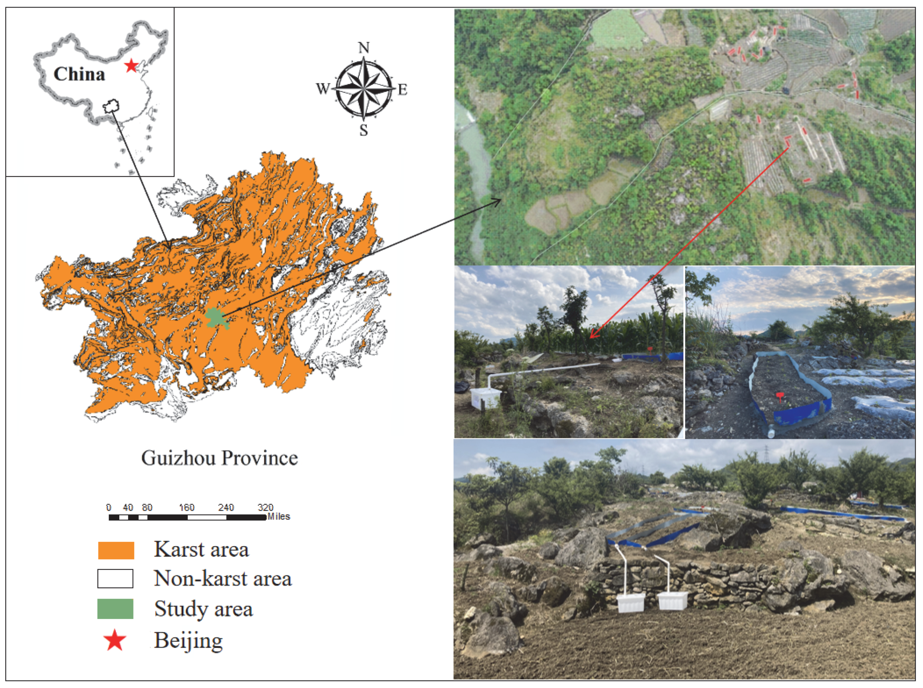
2.1. Field Investigation and Monitoring Test
2.2. Testing Material
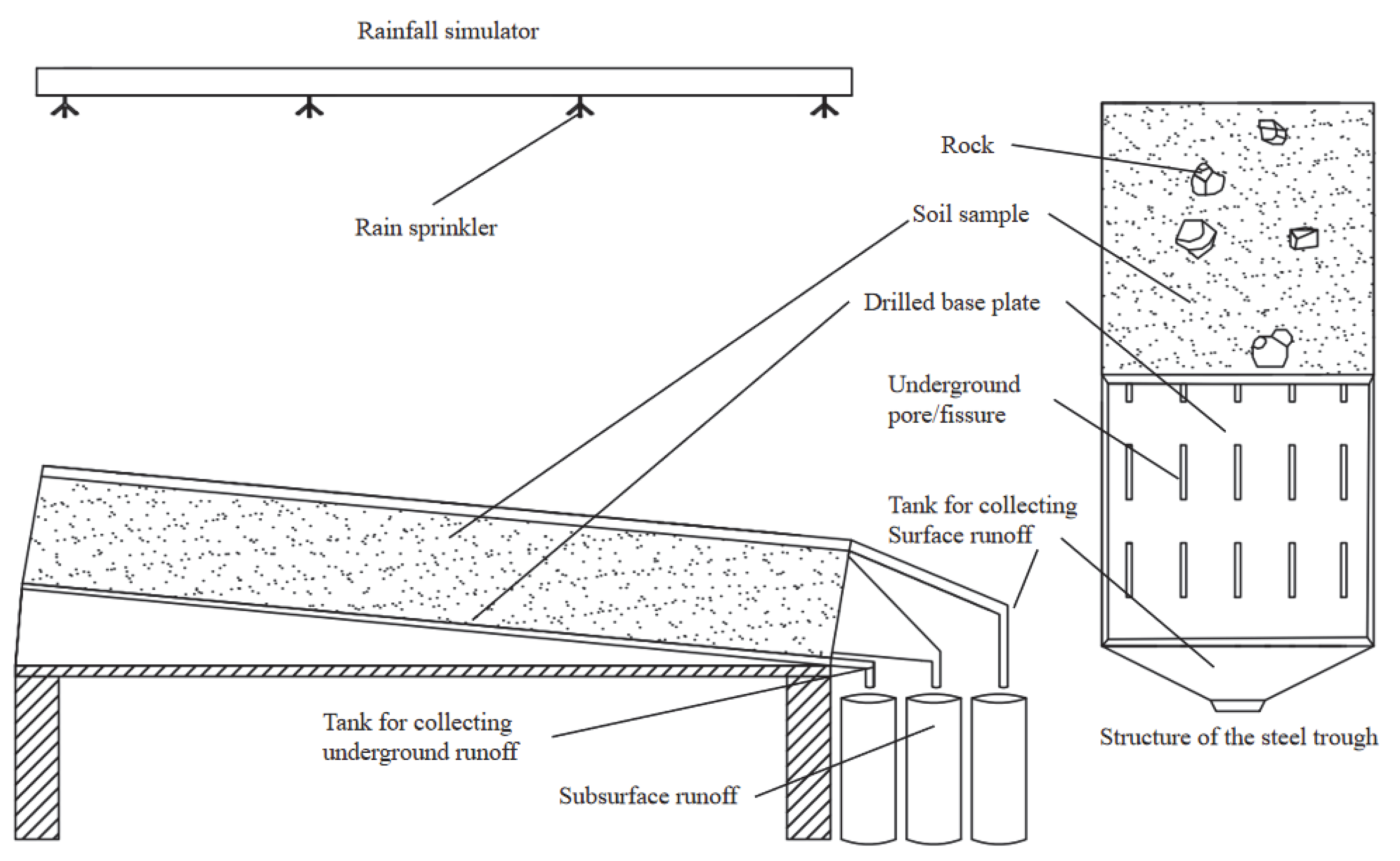
2.2.1. Testing Equipment
2.2.2. Test Soil
2.3. Experimental Design
2.4. Measuring Nutrient Composition
2.5. Test Method and Data Analysis
- (1)
- Flow measurement (R)
- (2)
- Sediment measurement (M)
- (3)
- Total nitrogen loss (QTN)
- (4)
- ammonium nitrogen loss ()
- (5)
- nitrate-nitrogen loss ().
3. Results Analysis
3.1. Effect of Extreme Rainfall on Runoff Change of Cultivated Land in Karst Gentle Slope
3.2. Effects of Extreme Rainfall on Nitrogen Loss in Karst Gentle Slope Farmland
3.2.1. Output Characteristics of Soil Runoff to Total Nitrogen in Karst Slope Farmland
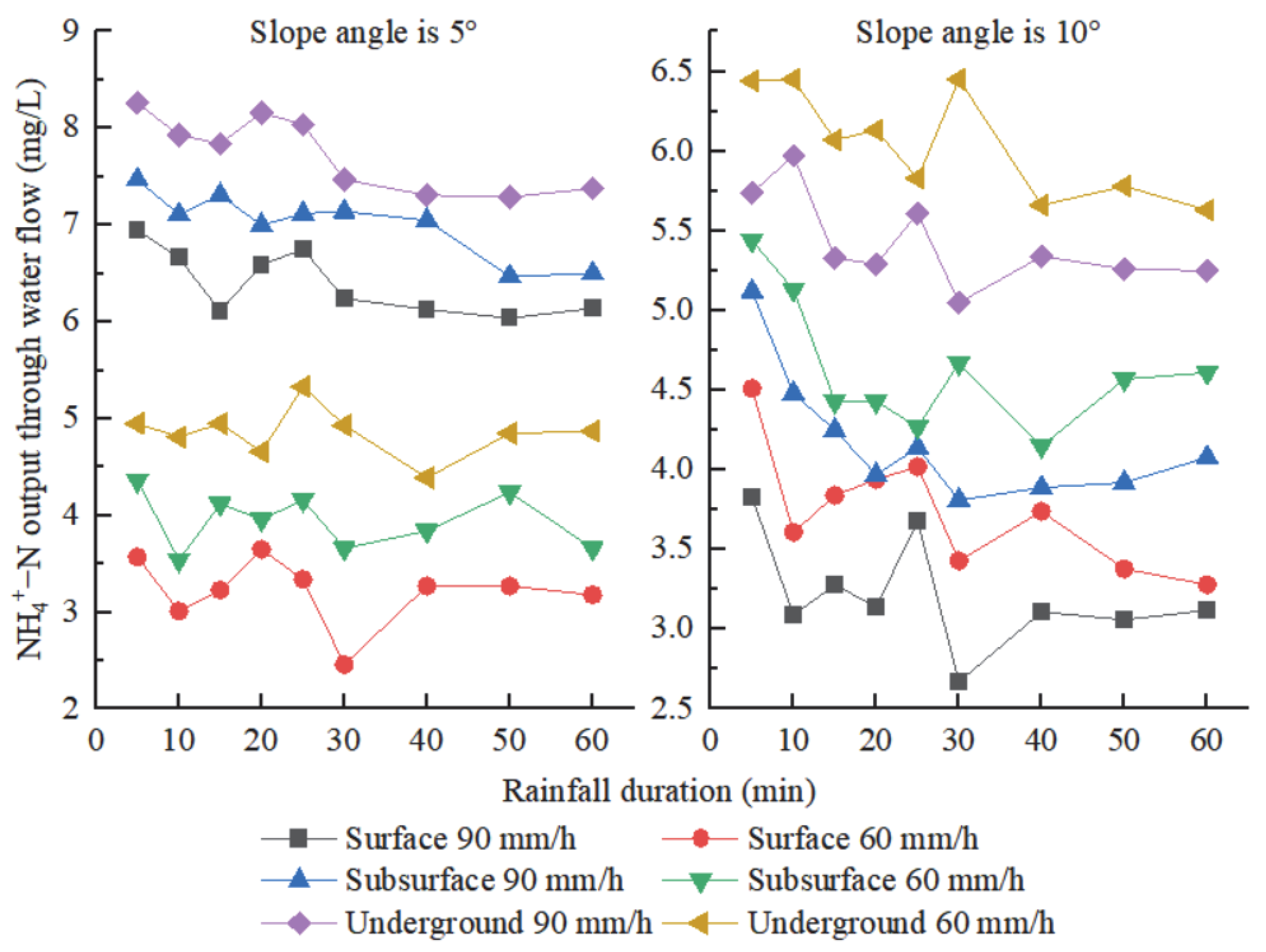
3.2.2. Characteristics of Soil Ammonium Nitrogen Loss in Karst Slope Farmland
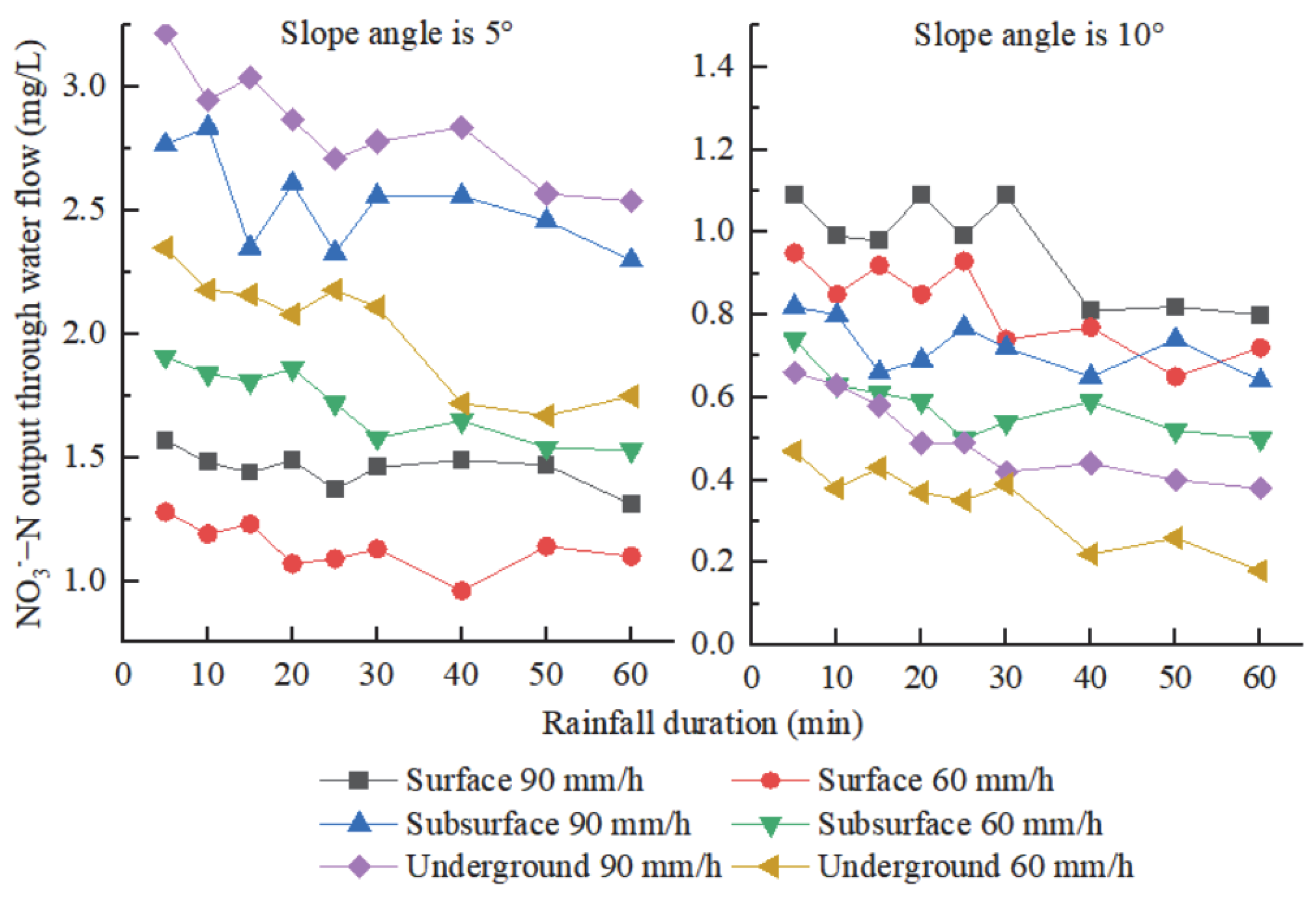
3.2.3. Characteristics of Soil Nitrate Nitrogen Loss in Karst Slope Farmland
3.3. Comprehensive Analysis of Nitrogen Loss in Karst Slope Farmland under Extreme Rainfall
4. Discussion
4.1. Effects of Rainfall Intensity and Slope on Runoff and Sediment Yield in Karst Gentle Slope Farmland
4.2. Effects of Rainfall Intensity and Slope on Nitrogen Loss in Karst Gentle Slope Farmland
4.2.1. Influence Factors of Rainfall Intensity and Slope Gradient on Ammonium Nitrogen Loss in Karst Gentle Slope Farmland
4.2.2. Effects of Rainfall Intensity and Slope on Nitrate-Nitrogen Loss in Karst Gentle Slope Farmland
4.2.3. The Influencing Factors of Rainfall Intensity and Slope on Total Nitrogen Loss in Karst Gentle Slope Farmland
5. Conclusions
Author Contributions
Funding
Data Availability Statement
Acknowledgments
Conflicts of Interest
References
- Rocci, K.S.; Lavallee, J.M.; Stewart, C.E.; Cotrufo, M.F. Soil organic carbon response to global environmental change depends on its distribution between mineral-associated and particulate organic matter: A meta-analysis. Sci. Total Environ. 2021, 793, 148569. [Google Scholar] [CrossRef] [PubMed]
- Bai, Y.; Zhou, Y. The main factors controlling spatial variability of soil organic carbon in a small Karst watershed, Guizhou Province, China. Geoderma 2020, 357, 113938. [Google Scholar] [CrossRef]
- Canfield, D.E.; Glazer, A.N.; Falkowski, P.G. The evolution and future of earth’s nitrogen cycle. Science 2010, 330, 192–196. [Google Scholar] [CrossRef] [PubMed] [Green Version]
- Xue, Z.; Cheng, M.; An, S. Soil nitrogen distributions for different land uses and landscape positions in a small watershed on Loess Plateau, China. Ecol. Eng. 2013, 60, 204–213. [Google Scholar] [CrossRef]
- Sun, B.; Gu, L.; Bao, L.; Zhang, S.; Wei, Y.; Bai, Z.; Zhuang, G.; Zhuang, X. Application of biofertilizer containing Bacillus subtilis reduced the nitrogen loss in agricultural soil. Soil Biol. Biochem. 2020, 148, 107911. [Google Scholar] [CrossRef]
- Dash, S.; Borah, S.S.; Kalamdhad, A.S. Study of the limnology of wetlands through a one-dimensional model for assessing the eutrophication levels induced by various pollution sources. Ecol. Model. 2020, 416, 108907. [Google Scholar] [CrossRef]
- Nunes, V.L.N.; Mulvaney, R.L. Controlling organic interference in determination of soil mineral nitrogen. Soil Sci. Soc. Am. J. 2021, 85, 919–928. [Google Scholar] [CrossRef]
- Wang, Z.; Miao, Y.; Li, S. Effect of ammonium and nitrate nitrogen fertilizers on wheat yield in relation to accumulated nitrate at different depths of soil in drylands of China. Field Crop. Res. 2015, 183, 211–224. [Google Scholar] [CrossRef]
- Liao, K.; Lv, L.; Lai, X.; Zhu, Q. Toward a framework for the multimodel ensemble prediction of soil nitrogen losses. Ecol. Model. 2021, 456, 109675. [Google Scholar] [CrossRef]
- Ludeña, C.; de Miguel, C.; Schuschny, A. Climate change and Carbon markets: Implications for developing countries. CEPAL Rev. 2016, 2015, 61–84. [Google Scholar] [CrossRef]
- Zhou, F.; Zhang, W.; Su, W.; Peng, H.; Zhou, S. Spatial differentiation and driving mechanism of rural water security in typical “engineering water depletion” of Karst mountainous area—A lesson of Guizhou, China. Sci. Total Environ. 2021, 793, 148387. [Google Scholar] [CrossRef] [PubMed]
- Xiao, P.; Xiao, B.; Adnan, M. Effects of Ca2+ on migration of dissolved organic matter in limestone soils of the southwest China Karst area. Land Degrad. Dev. 2021, 32, 5069–5082. [Google Scholar] [CrossRef]
- Li, S.; Ren, H.D.; Xue, L.; Chang, J.; Yao, X.H. Influence of bare rocks on surrounding soil moisture in the Karst rocky desertification regions under drought conditions. Catena 2014, 116, 157–162. [Google Scholar] [CrossRef]
- Wang, J.; Zou, B.; Liu, Y.; Tang, Y.; Zhang, X.; Yang, P. Erosion-creep-collapse mechanism of underground soil loss for the Karst rocky desertification in Chenqi village, Puding county, Guizhou, China. Environ Earth Sci. 2014, 72, 2751–2764. [Google Scholar] [CrossRef]
- Li, J.; Pu, J.; Zhang, T.; Xiong, X.; Wang, S.; Huo, W.; Yuan, D. Measurable sediment discharge from a Karst underground river in southwestern China: Temporal variabilities and controlling factors. Environ. Earth Sci. 2020, 79, 90. [Google Scholar] [CrossRef]
- Dai, Q.; Peng, X.; Zhao, L.; Shao, H.; Yang, Z. Effects of Underground Pore Fissures on Soil Erosion and Sediment Yield on Karst Slopes. Land Degrad. Dev. 2017, 28, 1922–1932. [Google Scholar] [CrossRef]
- Zhu, X.F.; Chen, H.S.; Fu, Z.Y.; Wang, K.L.; Zhang, W.; Xu, Q.X.; Fang, R.J. Runoff and nitrogen loss characteristics in soil-epiKarst system on a Karst shrub hillslope. Chin. J. Appl. Ecol. 2017, 28, 2197–2206. [Google Scholar] [CrossRef]
- Zhu, Z.; Wang, J.; Hu, M.; Jia, L. Geographical detection of groundwater pollution vulnerability and hazard in Karst areas of Guangxi Province, China. Environ. Pollut. 2019, 245, 627–633. [Google Scholar] [CrossRef] [PubMed]
- Guo, Z.; Zhang, X.; Dungait, J.A.J.; Green, S.M.; Quine, T.A. Contribution of soil microbial necromass to SOC stocks during vegetation recovery in a subtropical Karst ecosystem. Sci. Total Environ. 2021, 761, 143945. [Google Scholar] [CrossRef] [PubMed]
- Huo, J.; Yu, X.; Liu, C.; Chen, L.; Zheng, W.; Yang, Y.; Tang, Z. Effects of soil and water conservation management and rainfall types on runoff and soil loss for a sloping area in North China. Land Degrad. Dev. 2020, 31, 2117–2130. [Google Scholar] [CrossRef]
- Wang, Z.-J.; Yue, F.-J.; Wang, Y.-C.; Qin, C.-Q.; Ding, H.; Xue, L.-L.; Li, S.-L. The effect of heavy rainfall events on nitrogen patterns in agricultural surface and underground streams and the implications for Karst water quality protection. Agric. Water Manag. 2022, 266, 107600. [Google Scholar] [CrossRef]
- Fu, Z.Y.; Chen, H.S.; Zhang, W.; Xu, Q.X.; Wang, S.; Wang, K.L. Subsurface flow in a soil-mantled subtropical dolomite Karst slope: A field rainfall simulation study. Geomorphology 2015, 250, 1–14. [Google Scholar] [CrossRef]
- Fu, Z.; Chen, H.; Xu, Q.; Jia, J.; Wang, S.; Wang, K. Role of epiKarst in near-surface hydrological processes in a soil mantled subtropical dolomite Karst slope: Implications of field rainfall simulation experiments. Hydrol. Process. 2016, 30, 795–811. [Google Scholar] [CrossRef]
- Bai, X.; Zhang, X.; Long, Y.; Liu, X.; Siyu, Z. Use of 137Cs and 210Pbex measurements on deposits in a Karst depression to study the erosional response of a small Karst catchment in Southwest China to land-use change. Hydrol. Process. 2013, 27, 822–829. [Google Scholar] [CrossRef]
- Zheng, H.; Nie, X.; Liu, Z.; Mo, M.; Song, Y. Identifying optimal ridge practices under different rainfall types on runoff and soil loss from sloping farmland in a humid subtropical region of Southern China. Agric. Water Manag. 2021, 255, 107043. [Google Scholar] [CrossRef]
- Mohammed, S.; Hassan, E.; Abdo, H.G.; Szabo, S.; Mokhtar, A.; Alsafadi, K.; Al-Khouri, I.; Rodrigo-Comino, J. Impacts of rainstorms on soil erosion and organic matter for different cover crop systems in the western coast agricultural region of Syria. Soil Use Manag. 2021, 37, 196–213. [Google Scholar] [CrossRef]
- Mohammed, S.; Abdo, H.G.; Szabo, S.; Pham, Q.B.; Holb, I.J.; Linh, N.T.T.; Anh, D.T.; Alsafadi, K.; Mokhtar, A.; Kbibo, I.; et al. Estimating human impacts on soil erosion considering different hillslope inclinations and land uses in the coastal region of syria. Water 2020, 12, 2786. [Google Scholar] [CrossRef]
- Peng, X.; Dai, Q.; Li, C.; Zhao, L. Role of underground fissure flow in near-surface rainfall-runoff process on a rock mantled slope in the Karst rocky desertification area. Eng. Geol. 2018, 243, 10–17. [Google Scholar] [CrossRef]
- Peng, X.; Dai, Q.; Ding, G.; Li, C. Role of underground leakage in soil, water and nutrient loss from a rock-mantled slope in the Karst rocky desertification area. J. Hydrol. 2019, 578, 124086. [Google Scholar] [CrossRef]
- Cuomo, S.; Della Sala, M.; Novità, A. Physically based modelling of soil erosion induced by rainfall in small mountain basins. Geomorphology 2015, 243, 106–115. [Google Scholar] [CrossRef]
- Vaezi, A.R.; Ahmadi, M.; Cerdà, A. Contribution of raindrop impact to the change of soil physical properties and water erosion under semi-arid rainfalls. Sci. Total Environ. 2017, 583, 382–392. [Google Scholar] [CrossRef] [PubMed]
- Yan, Y.; Dai, Q.; Yuan, Y.; Peng, X.; Zhao, L.; Yang, J. Effects of rainfall intensity on runoff and sediment yields on bare slopes in a Karst area, SW China. Geoderma 2018, 330, 30–40. [Google Scholar] [CrossRef]
- Gentry, L.E.; David, M.B.; Smith, K.M.; Kovacic, D.A. Nitrogen cycling and tile drainage nitrate loss in a corn/soybean watershed. Agric. Ecosyst. Environ. 1998, 68, 85–97. [Google Scholar] [CrossRef]
- Zhang, Y.; Wu, H.; Yao, M.; Zhou, J.; Wu, K.; Hu, M.; Shen, H.; Chen, D. Estimation of nitrogen runoff loss from croplands in the Yangtze River Basin: A meta-analysis. Environ. Pollut. 2021, 272, 116001. [Google Scholar] [CrossRef]
- Zhang, S.; Chen, S.; Fenton, O.; Li, Y.; Chen, Q. Enhanced topsoil P leaching in a short term flooded calcareous soil with combined straw and ammonium nitrogen incorporation. Geoderma 2021, 402, 115322. [Google Scholar] [CrossRef]
- Ziadat, F.M.; Taimeh, A.Y. Effect of rainfall intensity, slope, land use and antecedent soil moisture on soil erosion in an arid environment. Land Degrad. Dev. 2013, 24, 582–590. [Google Scholar] [CrossRef]
- Shen, H.; Zheng, F.; Wen, L.; Han, Y.; Hu, W. Impacts of rainfall intensity and slope gradient on rill erosion processes at loessial hillslope. Soil Tillage Res. 2016, 155, 429–436. [Google Scholar] [CrossRef]
- Wu, L.; Peng, M.; Qiao, S.; Ma, X. Assessing impacts of rainfall intensity and slope on dissolved and adsorbed nitrogen loss under bare loessial soil by simulated rainfalls. Catena 2018, 170, 51–63. [Google Scholar] [CrossRef]
- Schröder, J.J.; Neeteson, J.J.; Oenema, O.; Struik, P.C. Does the crop or the soil indicate how to save nitrogen in maize production? Reviewing the state of the art. Field Crop. Res. 2000, 66, 151–164. [Google Scholar] [CrossRef]
- Kim, W.K.; Patterson, P.H. Ammonium-nitrogen transformation and nitrogen retention in broiler manure supplemented with a soil amendment containing nitrifying bacteria. J. Environ. Sci. Health Part B 2006, 41, 121–133. [Google Scholar] [CrossRef] [PubMed]
- Wang, H.J.; Wu, L.H.; Tao, Q.N.; Miller, D.D.; Welch, R.M. Glutamine nitrogen and ammonium nitrogen supplied as a nitrogen source is not converted into nitrate nitrogen of plant tissues of hydroponically Grown Pak-Choi (Brassica chinensis L.). J. Food Sci. 2009, 74, T21–T23. [Google Scholar] [CrossRef] [PubMed]
- Pareek, S.; Kumari, K.; Awan, T.; Sharma, A.; Shrivastava, D. Guar (Cyamopsis tetragonoloba [L.] Taub.) response to organic and inorganic nitrogen sources during early seedling growth. J. Plant Nutr. 2022, 45, 2135–2145. [Google Scholar] [CrossRef]
- Wang, Y.; Ying, H.; Yin, Y.; Zheng, H.; Cui, Z. Estimating soil nitrate leaching of nitrogen fertilizer from global meta-analysis. Sci. Total Environ. 2018, 657, 96–1029. [Google Scholar] [CrossRef] [PubMed]
- Stanley, C.D.; Green, R.E.; Khan, M.A.; Santo, L.T. Nitrogen-Fertilization Rate and Soil Nitrate Distribution for Microirrigated Sugarcane. Soil Sci. Soc. Am. J. 1990, 54, 217–222. [Google Scholar] [CrossRef]
- Song, X.; Gao, Y.; Green, S.M.; Dungait, J.A.J.; Peng, T.; Quine, T.A.; Xiong, B.; Wen, X.; He, N. Nitrogen loss from Karst area in China in recent 50 years: An in-situ simulated rainfall experiment’s assessment. Ecol. Evol. 2017, 7, 10131–10142. [Google Scholar] [CrossRef] [PubMed]
- Gao, R.; Dai, Q.; Gan, Y.; Peng, X.; Yan, Y. The production processes and characteristics of nitrogen pollution in bare sloping farmland in a Karst region. Environ. Sci. Pollut. Res. 2019, 26, 26900–26911. [Google Scholar] [CrossRef]
- Fan, J.; Lu, X.; Gu, S.; Guo, X. Improving nutrient and water use efficiencies using water-drip irrigation and fertilization technology in Northeast China. Agric. Water Manag. 2020, 241, 106352. [Google Scholar] [CrossRef]
- Gao, Y.; Zhu, B.; Wang, T.; Tang, J.L.; Zhou, P.; Miao, C.Y. Bioavailable phosphorus transport from a hillslope cropland of purple soil under natural and simulated rainfall. Environ. Monit. Assess. 2010, 171, 539–550. [Google Scholar] [CrossRef] [PubMed]
- Gao, Y.; Zhu, B.; Zhou, P.; Tang, J.L.; Wang, T.; Miao, C.Y. Effects of vegetation cover on phosphorus loss from a hillslope cropland of purple soil under simulated rainfall: A case study in China. Nutr. Cycl. Agroecosyst. 2009, 85, 263–273. [Google Scholar] [CrossRef]


| Index | Soil Layer | Moderate Rain (60 mm/h) | Extreme Rainfall (90 mm/h) | ||
|---|---|---|---|---|---|
| Slope Angle (5°) | Slope Angle (10°) | Slope Angle (5°) | Slope Angle (10°) | ||
| Runoff (L) | Surface | 15.24 ± 0.07 b | 16.96 ± 0.10 a | 23.1 ± 0.01 b | 31.15 ± 0.25 a |
| Subsurface | 10.29 ± 0.33 b | 10.94 ± 0.30 a | 11.49 ± 0.06 b | 13.04 ± 0.06 a | |
| Underground | 23.59 ± 0.22 b | 21.25 ± 0.43 a | 32.17 ± 1.8 a | 32.07 ± 2.04 a | |
| Sediment (g) | Surface | 35.19 ± 2.99 b | 46.28 ± 3.37 a | 44.32 ± 1.8 b | 49.72 ± 2.47 a |
| Subsurface | 0 | 0 | 0 | 0 | |
| Underground | 13.96 ± 1.37 b | 12.34 ± 0.16 b | 17.66 ± 0.59 a | 15.24 ± 1.45 b | |
| Index | Soil Layer | Moderate Rain (60 mm/h) | Extreme Rainfall (90 mm/h) | ||
|---|---|---|---|---|---|
| Slope Angle (5°) | Slope Angle (10°) | Slope Angle (5°) | Slope Angle (10°) | ||
| (mg) | Surface | 121.18 ± 0.79 b | 183.08 ± 1.67 a | 200.17 ± 2.72 b | 369.81 ± 5.80 a |
| Subsurface | 98.28 ± 2.84 b | 163.40 ± 3.36 a | 126.05 ± 1.18 b | 176.06 ± 0.87 a | |
| Underground | 392.94 ± 4.56 a | 385.64 ± 7.63 b | 454.54 ± 26.74 b | 625.18 ± 37.28 a | |
| Factors | ||||||
|---|---|---|---|---|---|---|
| F | p | F | p | F | p | |
| Slope angle | 3819.21 | <0.01 | 6306.63 | <0.01 | 6540.08 | <0.01 |
| Rainfall intensity | 334.95 | <0.01 | NA | >0.05 | 2092.77 | <0.01 |
| Rainfall duration | 76.21 | <0.01 | 82.42 | <0.01 | 252.95 | <0.01 |
| Slope angle × Rainfall intensity | 13.76 | <0.01 | 818.97 | <0.01 | 193.83 | <0.01 |
| Slope angle × Rainfall duration | 12.22 | <0.01 | 7.54 | <0.01 | 15.28 | <0.01 |
| Rainfall intensity × Rainfall duration | 6.98 | <0.01 | 8.94 | <0.01 | 16.87 | <0.01 |
| Slope angle × Rainfall intensity × Rainfall duration | 3.49 | <0.01 | 13.71 | <0.01 | 18.73 | <0.01 |
| Index | Soil Layer | Moderate Rain (60 mm/h) | Extreme Rainfall (90 mm/h) | ||
|---|---|---|---|---|---|
| Slope Angle (5°) | Slope Angle (10°) | Slope Angle (5°) | Slope Angle (10°) | ||
| (mg) | Surface | 47.20 ± 0.16 b | 63.61 ± 0.35 a | 147.88 ± 0.55 a | 100.33 ± 0.46 b |
| Subsurface | 40.63 ± 1.22 b | 50.73 ± 1.76 a | 80.59 ± 0.71 a | 54.56 ± 0.53 b | |
| Underground | 114.64 ± 2.69 b | 128.51 ± 14.74 a | 249.06 ± 14.46 a | 174.07 ± 2.30 b | |
| Factors | ||||||
|---|---|---|---|---|---|---|
| F | p | F | p | F | p | |
| Slope angle | 2986.32 | <0.01 | 1924.69 | <0.01 | 267.71 | <0.01 |
| Rainfall intensity | 3597.58 | <0.01 | 2870.64 | <0.01 | 1080.38 | <0.01 |
| Rainfall duration | 67.93 | <0.01 | 55.05 | <0.01 | 20.78 | <0.01 |
| Slope angle × Rainfall intensity | 6869.04 | <0.01 | 5174.29 | <0.01 | 2591.37 | <0.01 |
| Slope angle × Rainfall duration | 10.2 | <0.01 | 23.44 | <0.01 | 5.11 | <0.01 |
| Rainfall intensity × Rainfall duration | 14.63 | <0.01 | 9.28 | <0.01 | 5.89 | <0.01 |
| Slope angle × Rainfall intensity × Rainfall duration | 21.33 | <0.01 | 10.49 | <0.01 | 6.54 | <0.01 |
| Index | Soil Layer | Moderate Rain (60 mm/h) | Extreme Rainfall (90 mm/h) | ||
|---|---|---|---|---|---|
| Slope Angle (5°) | Slope Angle (10°) | Slope Angle (5°) | Slope Angle (10°) | ||
| (mg) | Surface | 17.26 ± 0.10 a | 13.93 ± 0.79 b | 33.58 ± 0.17 a | 29.98 ± 0.47 b |
| Subsurface | 17.66 ± 0.32 a | 6.35 ± 0.08 b | 29.08 ± 0.52 a | 9.38 ± 0.84 b | |
| Underground | 47.68 ± 1.28 a | 7.22 ± 2.02 b | 91.29 ± 5.82 a | 15.98 ± 0.36 b | |
| Factors | ||||||
|---|---|---|---|---|---|---|
| F | p | F | p | F | p | |
| Slope angle | 412.45 | <0.01 | 2812.45 | <0.01 | 10737.33 | <0.01 |
| Rainfall intensity | 136.86 | <0.01 | 294.54 | <0.01 | 628.63 | <0.01 |
| Rainfall duration | 6.61 | <0.01 | 6.02 | <0.01 | 28.17 | <0.01 |
| Slope angle × Rainfall intensity | 20.52 | <0.01 | 147.68 | <0.01 | 286.35 | <0.01 |
| Slope angle × Rainfall duration | 2.14 | <0.05 | NA | >0.05 | 4.79 | <0.01 |
| Rainfall intensity × Rainfall duration | NA | >0.05 | NA | >0.05 | 3.03 | <0.01 |
| Factors | Rainfall Duration | Slope Angle | Rainfall Intensity | Surface Runoff | Subsurface Runoff | Underground Runoff |
|---|---|---|---|---|---|---|
| Surface | −0.30 ** | 0.87 ** | 0.26 ** | −0.06 | −0.20 * | −0.17 |
| Subsurface | −0.20 * | 0.88 ** | 0.00 | −0.08 | −0.14 | −0.15 |
| Underground | −0.36 ** | 0.76 ** | −0.43 ** | −0.033 ** | −0.34 ** | −0.029 ** |
| Surface | −0.10 * | −0.46 ** | 0.50 ** | −0.06 | −0.09 | −0.14 |
| Subsurface | −0.15 * | −0.42 ** | 0.52 ** | −0.11 | −0.15 | −0.19 |
| Underground | −0.17 * | −0.25 ** | 0.50 ** | −0.11 | −0.16 | −0.22 * |
| Surface | −0.25 ** | −0.75 ** | 0.43 ** | −0.22 * | −0.27 ** | −0.03 ** |
| Subsurface | −0.10 * | −0.91 ** | 0.29 ** | −0.13 | −0.13 | −0.13 |
| Underground | −0.13 * | −0.95 ** | 0.23 * | −0.19 | −0.17 | −0.18 |
| Indexes | Regression Equation | R2 | Standardized Coefficients | ||
|---|---|---|---|---|---|
| Beta (×1) | Beta (×2) | Beta (×3) | |||
| Surface | y = 0.480 × 1 + 2.490 × 2+ 0.887 × 3 − 56.376 | 0.826 | 0.359 | 0.311 | 0.775 |
| Subsurface | y = 0.068 × 1 + 1.301 × 2 + 0.589 × 3 − 16.265 | 0.863 | 0.087 | 0.279 | 0.882 |
| Underground | y = 3.070 × 2 + 2.044 × 3 − 34.763 | 0.807 | Sig > 0.05 | 0.189 | 0.878 |
| Surface | y = 0.246 × 1 − 0.384 × 2 + 0.368 × 3 − 16.243 | 0.814 | 0.444 | 0.116 | 0.776 |
| Subsurface | y = 0.077 × 1 − 0.197 × 2 + 0.237 × 3 − 4.891 | 0.831 | 0.243 | −0.104 | 0.872 |
| Underground | y = 0.204 × 1 + 0.715 × 3 − 19.345 | 0.877 | 0.223 | Sig > 0.05 | 0.909 |
| Surface | y = 0.058 × 1 − 1.000 × 2 + 0.092 × 3 − 3.704 | 0.829 | 0.432 | −0.123 | 0.792 |
| Subsurface | y = 0.027 × 1 − 0.333 × 2 + 0.063 × 3 + 0.351 | 0.741 | 0.243 | −0.498 | 0.658 |
| Underground | y = 0.053 × 1 − 0.981 × 2 + 0.137 × 3 + 3.043 | 0.739 | 0.193 | −0.599 | 0.586 |
Publisher’s Note: MDPI stays neutral with regard to jurisdictional claims in published maps and institutional affiliations. |
© 2022 by the authors. Licensee MDPI, Basel, Switzerland. This article is an open access article distributed under the terms and conditions of the Creative Commons Attribution (CC BY) license (https://creativecommons.org/licenses/by/4.0/).
Share and Cite
Wang, Y.; Dai, Q.; Ding, P.; Li, K.; Yi, X.; He, J.; Peng, X.; Yan, Y.; Zhao, M.; Yang, Y. Rapid Response of Runoff Carrying Nitrogen Loss to Extreme Rainfall in Gentle Slope Farmland in the Karst Area of SW China. Water 2022, 14, 3341. https://doi.org/10.3390/w14203341
Wang Y, Dai Q, Ding P, Li K, Yi X, He J, Peng X, Yan Y, Zhao M, Yang Y. Rapid Response of Runoff Carrying Nitrogen Loss to Extreme Rainfall in Gentle Slope Farmland in the Karst Area of SW China. Water. 2022; 14(20):3341. https://doi.org/10.3390/w14203341
Chicago/Turabian StyleWang, Yong, Quanhou Dai, Pengwei Ding, Kuaifen Li, Xingsong Yi, Jie He, Xudong Peng, Youjin Yan, Min Zhao, and Yingchong Yang. 2022. "Rapid Response of Runoff Carrying Nitrogen Loss to Extreme Rainfall in Gentle Slope Farmland in the Karst Area of SW China" Water 14, no. 20: 3341. https://doi.org/10.3390/w14203341
APA StyleWang, Y., Dai, Q., Ding, P., Li, K., Yi, X., He, J., Peng, X., Yan, Y., Zhao, M., & Yang, Y. (2022). Rapid Response of Runoff Carrying Nitrogen Loss to Extreme Rainfall in Gentle Slope Farmland in the Karst Area of SW China. Water, 14(20), 3341. https://doi.org/10.3390/w14203341


