
A GIS-Based Model for Flood Shelter Locations and Pedestrian Evacuation Scenarios in a Rural Mountain Catchment in Romania


Abstract
1. Introduction
2. Materials and Methods
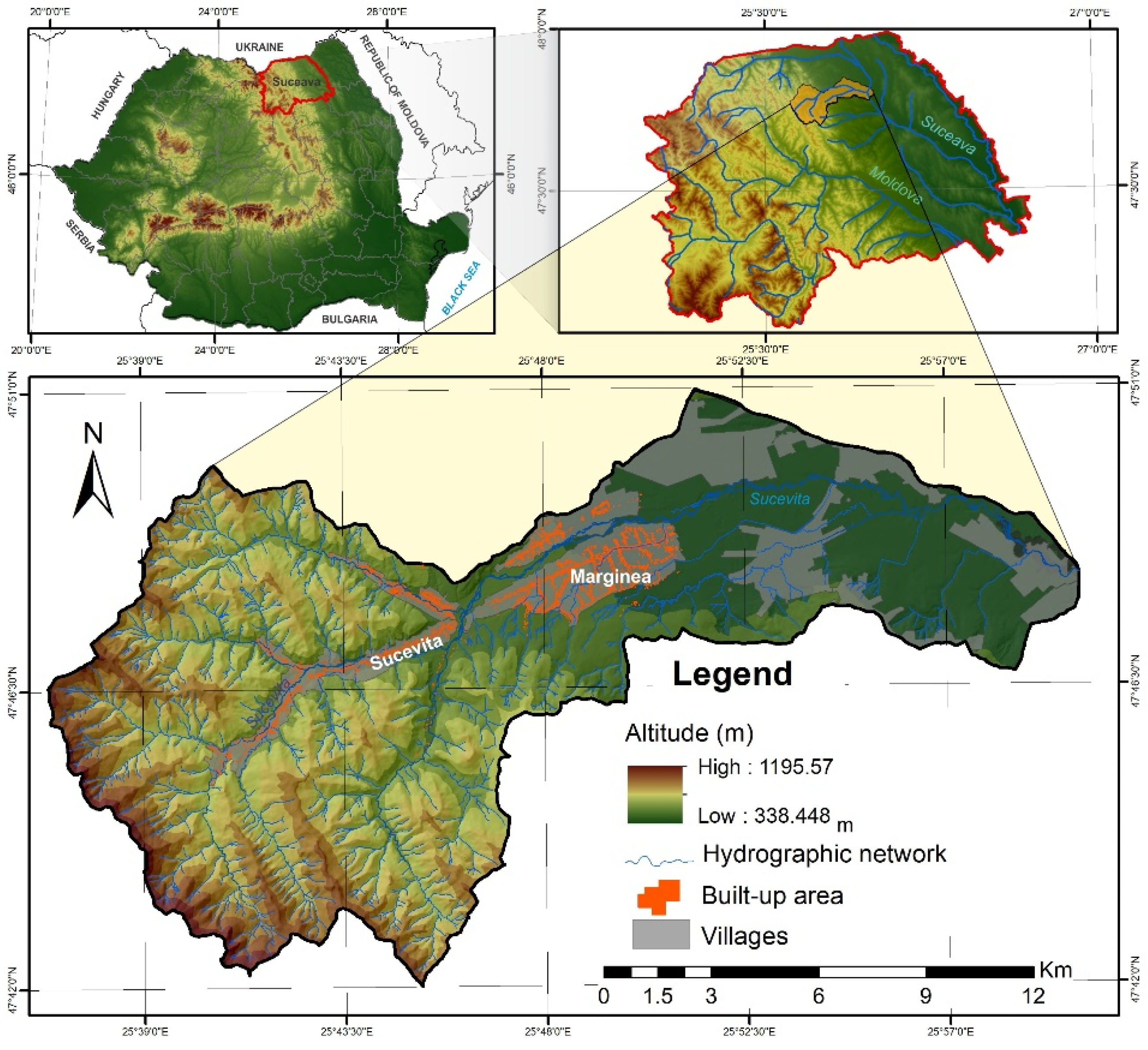
2.1. Study Area
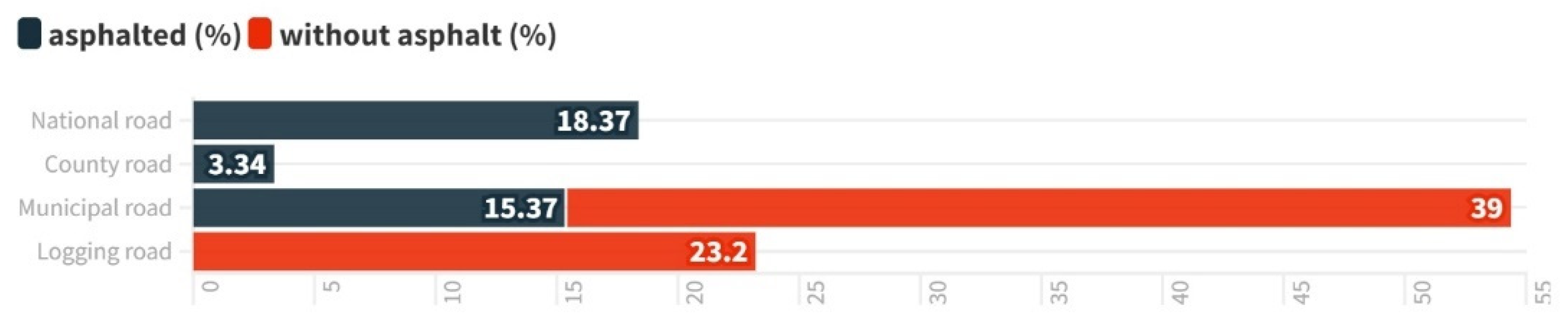
2.2. Data Used
2.3. Methodology
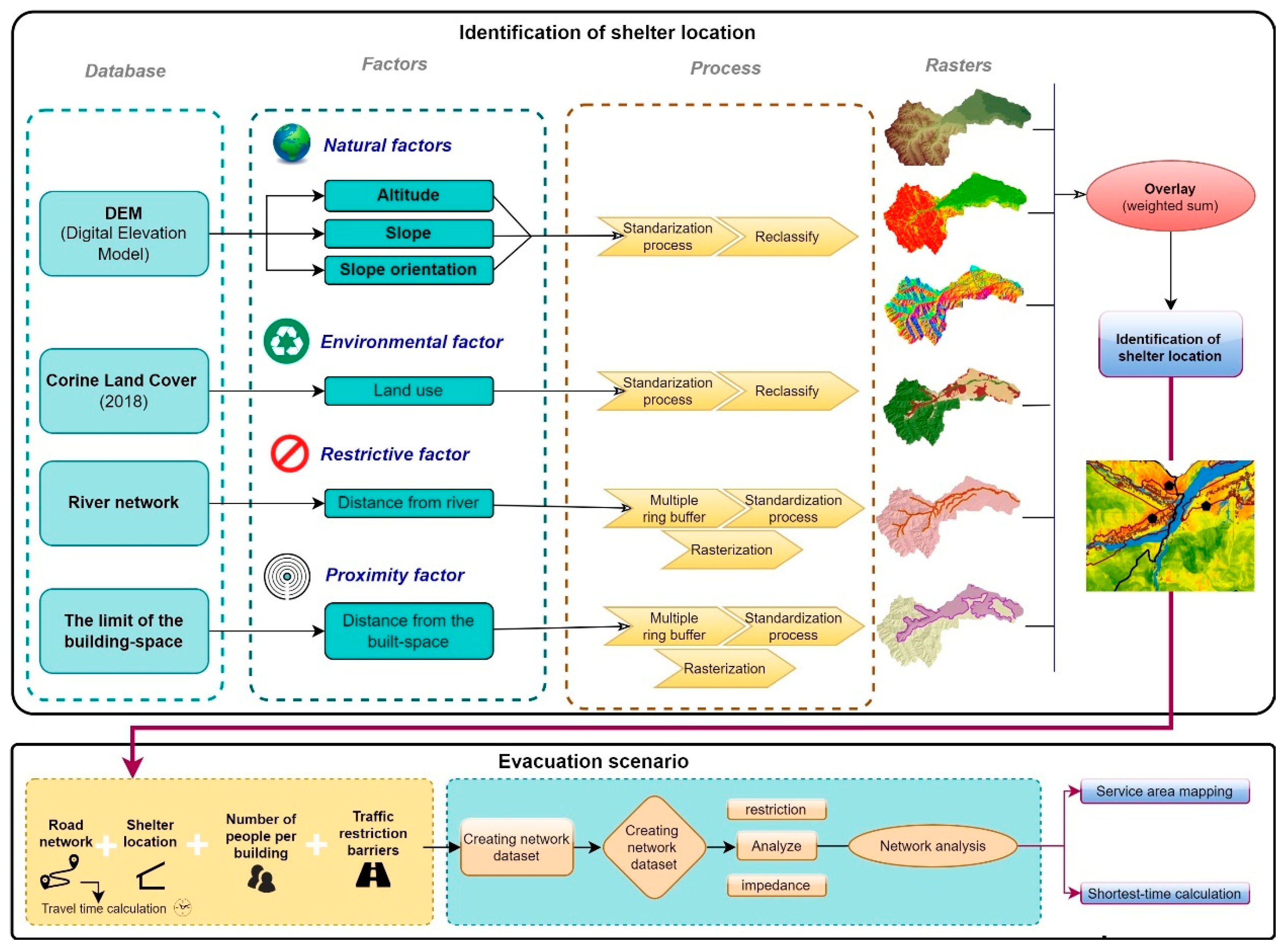
2.3.1. Suitability of Terrain for Shelter Locations
- Fsl—favourability for shelter locations,
- Fi—factors taken into analysis,
- Evi—evaluation rate for each factor from Table 1.
2.3.2. Pedestrian Evacuation
3. Results
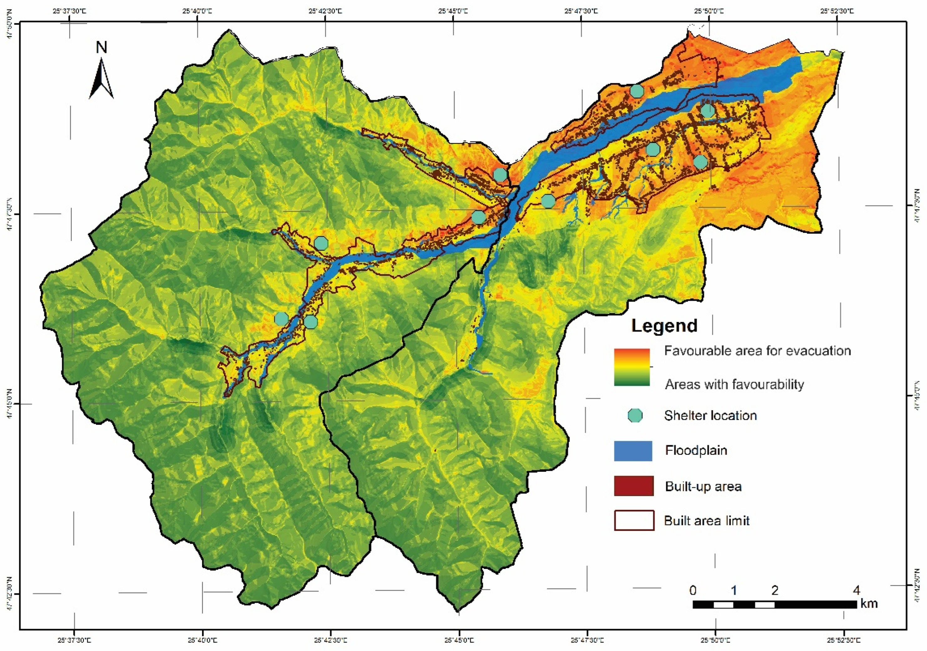
3.1. Spatial Assessment of Shelter Location
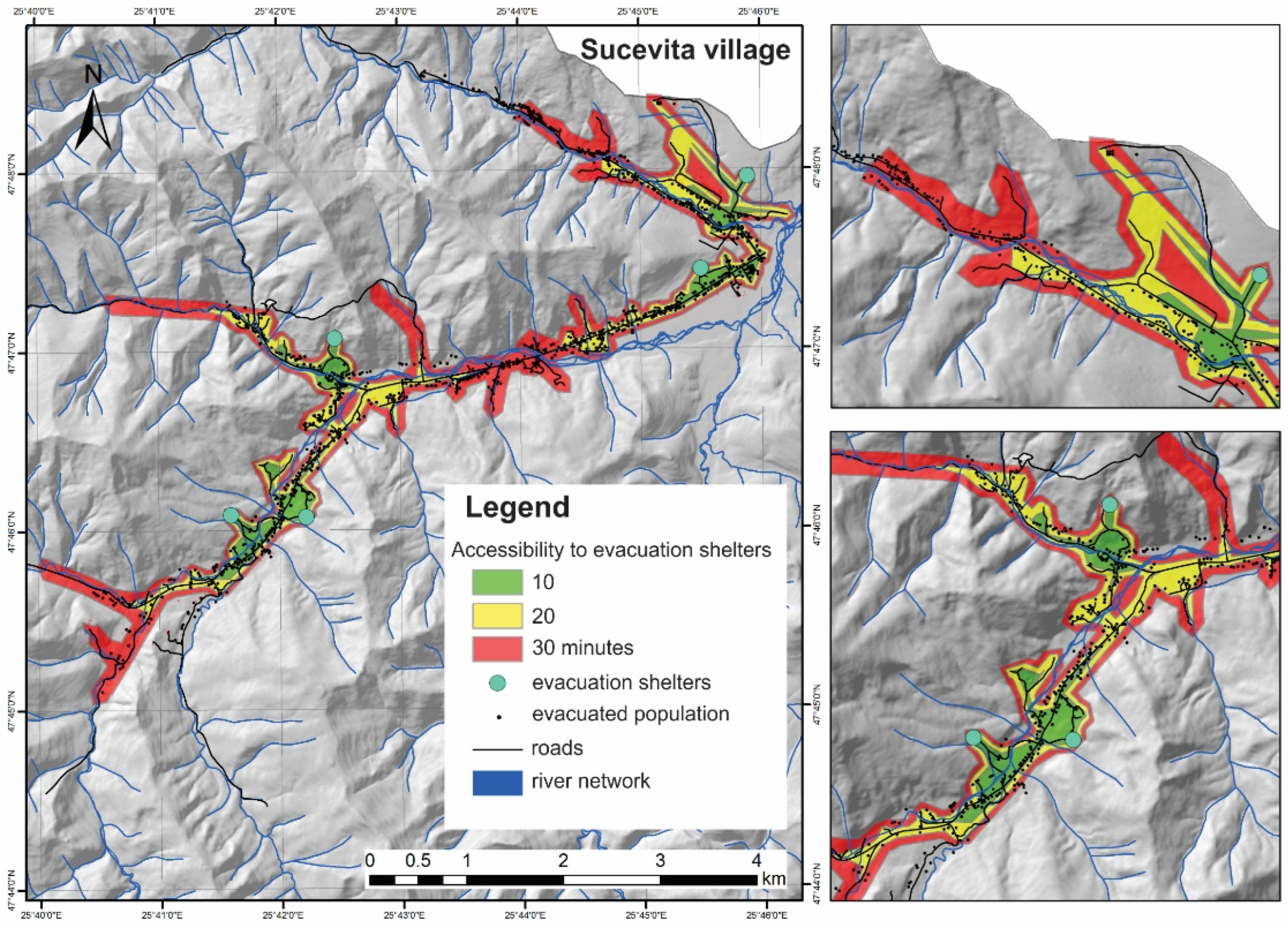
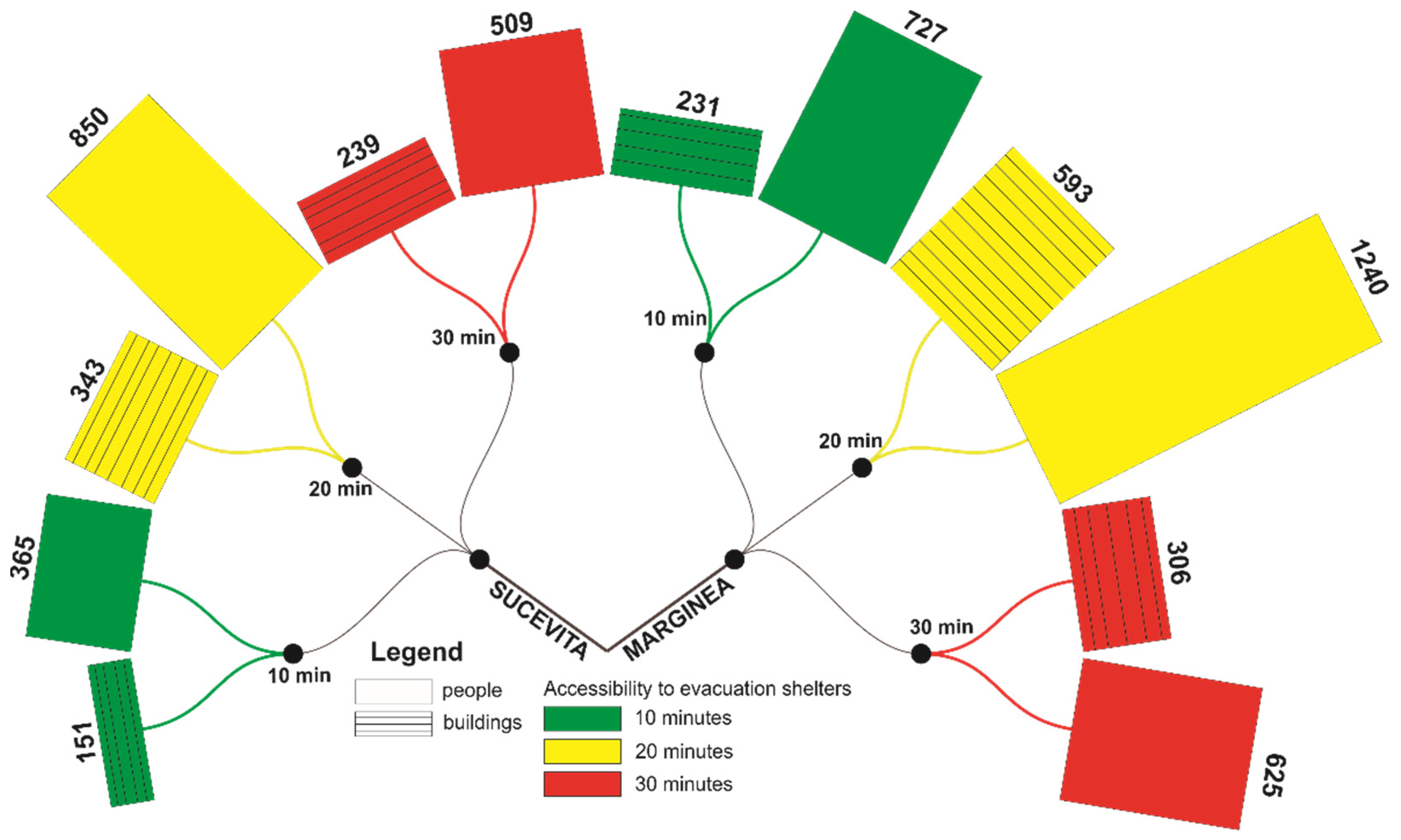
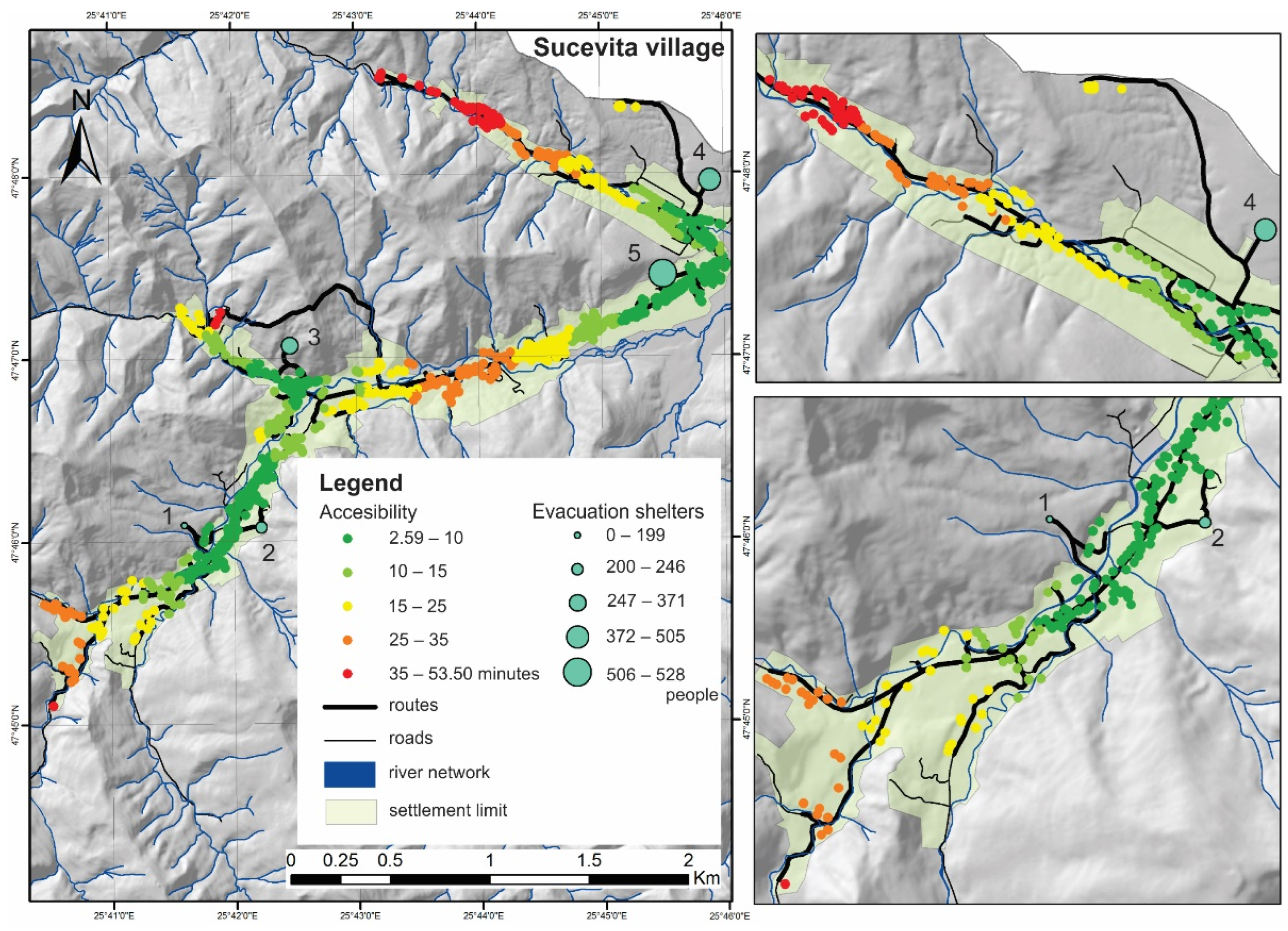
3.2. Evacuation Routes Simulations
4. Discussion
5. Conclusions
Author Contributions
Funding
Data Availability Statement
Acknowledgments
Conflicts of Interest
References
- Rosselló, J.; Becken, S.; Santana-Gallego, M. The effects of natural disasters on international tourism: A global analysis. Tour. Manag. 2020, 79, 104080. [Google Scholar] [CrossRef] [PubMed]
- Hsiao, C.C.; Sun, M.C.; Chen, A.Y.; Hsu, Y.T. Location problems for shelter-in-place deployment: A case study of vertical evacuation upon dam-break floods. Int. J. Disaster Risk Reduc. 2021, 57, 102048. [Google Scholar] [CrossRef]
- Merz, B.; Kreibich, H.; Schwarze, R.; Thieken, A. Review article “Assessment of economic flood damange”. Nat. Hazards Earth Syst. Sci. 2010, 10, 1697–1724. [Google Scholar] [CrossRef]
- Pathak, S.; Panta, H.K.; Bhandari, T.; Paudel, K.P. Flood vulnerability and its influencing factors. Nat. Hazard. 2020, 103, 2175–2196. [Google Scholar] [CrossRef]
- Lasage, R.; Veldkamp, T.I.E.; de Moel, H.; Van, T.C.; Phi, H.L.; Vellinga, P.; Aerts, J.C.J.H. Assessment of the effectiveness of flood adaptation strategies for HCMC. Nat. Hazards Earth Syst. Sci. 2014, 14, 1441–1457. [Google Scholar] [CrossRef]
- Milly, P.C.; Betancourt, J.; Falkenmark, M.; Hirsch, R.M.; Kundzewicz, Z.W.; Lettenmaier, D.P.; Stouffer, R.J. Stationarity is dead: Whither water management? Science 2008, 319, 573–574. [Google Scholar] [CrossRef]
- Conitz, F.; Zingraff-Hamed, A.; Lupp, G.; Pauleit, S. Non-Structural Flood Management in European Rural Mountain Areas—Are Scientists Supporting Implementation? Hydrology 2021, 8, 167. [Google Scholar] [CrossRef]
- Mikša, K.; Kalinauskas, M.; Inácio, M.; Pereira, P. Implementation of the European Union Floods Directive—Requirements and national transposition and practical application: Lithuanian case-study. Land Use Policy 2021, 100, 104924. [Google Scholar] [CrossRef]
- Hapciuc, O.E.; Minea, I.; Romanescu, G.; Tomașciuc, A.I. Flash flood risk management for small basins in the mountain-plateau transition zone. Case study for Sucevița catchement (Romania). In Proceedings of the 2015 SGEM International Multidisciplinary Scientific Geoconferences, Albena, Bulgaria, 18–24 June 2015; Volume 1, pp. 301–308. [Google Scholar] [CrossRef]
- Dieperink, C.; Hegger, D.T.; Bakker, M.H.N.; Kundzewicz, Z.W.; Green, C.; Driessen, P.P.J. Recurrent governance challenges in the implementation and alignment of flood risk management strategies: A review. Water Resour. Manag. 2016, 30, 4467–4481. [Google Scholar] [CrossRef]
- Hapciuc, O.E.; Iosub, M.; Tomașciuc, A.I.; Minea, I.; Romanescu, G.H. Identification of the potential risk areas regarding the floods occurrence within small mountain catchments. Int. Conf. Geobalcanica 2016, 1, 177–183. [Google Scholar] [CrossRef]
- Zeleňáková, M.; Fijko, R.; Labant, S.; Weiss, E.; Markovič, G.; Weiss, R. Flood risk modelling of the Slatvinec stream in Kružlov village, Slovakia. J. Cleaner Prod. 2019, 212, 109–118. [Google Scholar] [CrossRef]
- Alam, M.J.; Habib, M.A.; Pothier, R. Shelter locations in evacuation: A Multiple Criteria Evaluation combined with flood risk and traffic microsimulation modeling. Int. J. Disaster Risk Reduct. 2021, 53, 102016. [Google Scholar] [CrossRef]
- Trindade, A.; Teves-Costa, P.; Catita, C. A GIS-based analysis of constraints on pedestrian tsunami evacuation routes: Cascais case study (Portugal). Nat. Hazard 2018, 93, 169–185. [Google Scholar] [CrossRef]
- Lee, Y.H.; Keum, H.J.; Han, K.Y.; Hong, W.H. A hierarchical flood shelter location model for walking evacuation planning. Environ. Hazards 2021, 20, 432–455. [Google Scholar] [CrossRef]
- Sritart, H.; Miyazaki, H.; Kanbara, S.; Hara, T. Methodology and application of spatial vulnerability assessment for evacuation shelters in disaster planning. Sustainability 2020, 12, 7355. [Google Scholar] [CrossRef]
- Hapciuc, O.E.; Iosub, M.; Enea, A.; Romanescu, G. Analyse spatiale de la gestion d’évacuation en cas d’inondations. Étude de cas: Le bassin de la Suceviţa, Roumanie. In Proceedings of the Le 3e colloque de l’AFGP “La géographie physique et les risques de pertes et prejudices lies aux changements climatiques”, Sassari, Italia, 19–21 May 2016. [Google Scholar]
- Lumbroso, D.; Stone, K.; Vinet, F. An assessment of flood emergency plans in England and Wales, France and the Netherlands. Nat. Hazard. 2011, 58, 341–363. [Google Scholar] [CrossRef]
- Gan, H.E.; Richter, K.F.; Shi, M.; Winter, S. Integration of simulation and optimization for evacuation planning. Simul. Modell. Pract. Theory 2016, 67, 59–73. [Google Scholar] [CrossRef]
- Esposito Amideo, E.; Scaparra, M.P.; Sforza, A.; Sterle, C. An integrated user-system approach for shelter location and evacuation routing. Networks 2021, 78, 46–68. [Google Scholar] [CrossRef]
- Lindell, M.K.; Prater, C.S. Critical behavioral assumptions in evacuation time estimate analysis for private vehicles: Examples from hurricane research and planning. J. Urban Plan Dev. 2007, 133, 18–29. [Google Scholar] [CrossRef]
- Melgarejo, L.F.; Lakes, T. Urban adaptation planning and climate-related disasters: An integrated assessment of public infrastructure serving as temporary shelter during river floods in Colombia. Int. J. Disaster Risk Reduc. 2014, 9, 147–158. [Google Scholar] [CrossRef]
- Chang, H.S.; Liao, C.H. Planning emergency shelter locations based on evacuation behavior. Nat. Hazard 2015, 76, 1551–1571. [Google Scholar] [CrossRef]
- Romanescu, G.; Hapciuc, O.E.; Minea, I.; Iosub, M. Flood vulnerability assessment in the mountain-plateau transition zone. Case study for Marginea village (Romania). J. Flood Risk Manag. 2018, 11 (Suppl. S1), S502–S513. [Google Scholar] [CrossRef]
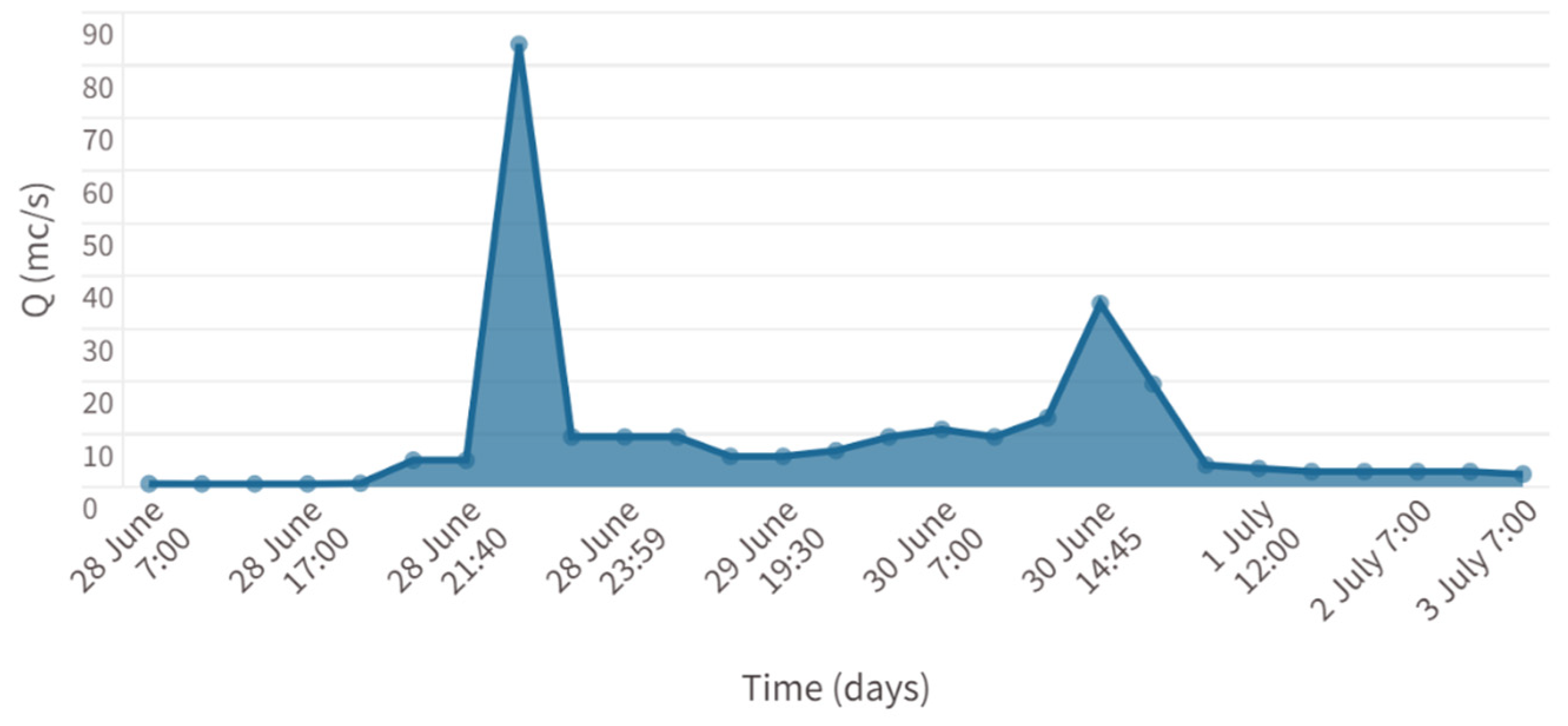
- Hapciuc, O.E.; Minea, I.; Iosub, M.; Romanescu, G.H. The role of the hydro-climatic conditions in causing high floods in the Sucevița river catchment. Air Water Compon. Environ. 2015, 1, 201–208. [Google Scholar] [CrossRef]
- Iosub, M.; Minea, I.; Chelariu, O.E.; Ursu, A. Assessment of flash flood susceptibility potential in Moldavian Plain (Romania). J. Flood Risk Manag. 2020, 13, e12588. [Google Scholar] [CrossRef]
- Georgescu, E.S.; Gociman, C.O.; Craifaleanu, I.G.; Georgescu, M.S.; Moscu, C.I.; Dragomir, C.S.; Dobre, D. Multi-Hazard Scenarios and Impact Mapping for a Protected Built Area in Bucharest, as a Base for Emergency Planning. In International Conference on Dynamics of Disasters; Springer: Cham, Germany, 2016; pp. 57–70. [Google Scholar]
- Leon, F.; Atanasiu, G.M.; Bunea, G. Critical assessment of road network resilience using an agent-based evacuation model. In Proceedings of the 7th Balkan Conference on Informatics Conference, Craiova, Romania, 2–4 September 2015; pp. 1–8. [Google Scholar]
- Bunea, G.; Leon, F.; Atanasiu, G.M. Postdisaster evacuation scenarios using multiagent system. J. Comput. Civ. Eng. 2016, 30, 05016002. [Google Scholar] [CrossRef]
- Nicoară, E.M.; Haidu, I.; Imbroane, A. Identification of areas of preventive evacuation and accommodation of population, animals and property necessary for the defense plan of the Baciu Commune, Annals of “Alexandru Ioan Cuza University” of Iasi. In Proceedings of the International Symposium on Geographic Information Systems, Iasi, Romania, 30 September 2011; pp. 36–42. [Google Scholar]
- Nicoară, E.M.; Haidu, I. Creation of the roads metwork as a network dataset within a geodatabase. Geogr. Tech. 2011, 2, 81–86. [Google Scholar]
- Allafta, C.H. Opp: GIS-based multi-criteria analysis for flood prone areas mapping in the trans-boundary Shatt Al-Arab basin, Iraq-Iran. Geomat. Nat. Hazards Risk 2021, 12, 2087–2116. [Google Scholar] [CrossRef]
- De Brito, M.M.; Evers, M. Multi-criteria decision-making for flood risk management: A survey of the current state of the art. Nat. Hazards Earth Syst. Sci. 2016, 16, 1019–1033. [Google Scholar]
- Popa, M.C.; Simion, A.G.; Peptenatu, D.; Dima, C.; Draghici, C.C.; Florescu, M.-S.; Dobrea, C.R.; Diaconu, D.C. Diaconu: Spatial assessment of flash-flood vulnerability in the Moldova river catchment (N Romania) using the FFPI. J. Flood Risk Manag. 2020, 13, e12624. [Google Scholar] [CrossRef]
- Chelariu, O.E. Flood Risk Management in the Sucevița Catchment; Alexandru Ioan Cuza University Press: Iasi, Romania, 2020. (In Romanian) [Google Scholar]
- Copernicus Land Monitoring Service. 2020. Available online: https://land.copernicus.eu/ (accessed on 13 June 2021).
- Coles, A.R. Identification and evaluation of flood-avoidance routes in Tucson, Arizona. Int. J. Disaster Risk Reduct. 2020, 48, 101597. [Google Scholar] [CrossRef]
- Nicoară, E.M. Study on the implementation of GIS in flood emergency management. Application to the Communes in the Contact Area of the Gilau Mountains—Someselor Plateau, Cluj-Napoca. Ph.D. Thesis, Bábes Bolyai University, Cluj-Napoca, Romania, 2012. (In Romanian). [Google Scholar]
- Taylor, M.A.; Freeman, S.K. A review of planning and operational models used for emergency evacuation situations in Australia. Procedia Eng. 2010, 3, 3–14. [Google Scholar] [CrossRef][Green Version]
- Stepanov, A.; Smith, J.M. Multi-objective evacuation routing in transportation networks. Eur. J. Oper. Res. 2009, 198, 435–446. [Google Scholar] [CrossRef]
- Stålhult, S.; Andersson, S. Hospital Exposed to Flooding in Manila City, Philipines—GIS Analysis of Alternative Emergency Routes and Allocation of Emergency Service and Temporary Medical Center. Karlstad University, Karlstad, Sweden, 2014; pp. 1–67. [Google Scholar]
- Post, J.; Wegscheider, S.; Mück, M.; Zosseder, K.; Kiefl, R.; Steinmetz, T.; Strunz, G. Assessment of human immediate response capability related to tsunami threats in Indonesia at a sub-national scale. Nat. Hazards Earth Syst. Sci. 2009, 9, 1075–1086. [Google Scholar] [CrossRef]
- Sugimoto, T.; Murakami, H.; Kozuki, Y.; Nishikawa, K.; Shimada, T. A human damage prediction method for tsunami disasters incorporating evacuation activities. Nat. Hazard 2003, 29, 587–602. [Google Scholar] [CrossRef]
- González-Riancho, P.; Aguirre-Ayerbe, I.; Aniel-Quiroga, I.; Abad, S.; González, M.; Larreynaga, J.; Gavidia, F.; Gutierrez, O.Q.; Alvarez-Gomez, J.A.; Medina, R. Tsunami evacuation modelling as a tool for risk reduction: Application to the coastal area of El Salvador. Nat. Hazards Earth Syst. Sci. 2013, 13, 3249–3270. [Google Scholar] [CrossRef]
- Boguslawski, P.; Mahdjoubi, L.; Zverovich, V.; Fadli, F. A dynamic approach for evacuees’ distribution and optimal routing in hazardous environments. Autom Constr. 2018, 94, 11–21. [Google Scholar] [CrossRef]
- Bernardini, G.; Quagliarini, E. How to account for the human motion to improve flood risk assessment in urben areas. Water 2020, 12, 1316. [Google Scholar] [CrossRef]
- Directive 2007/60/EC of the European Parliament and of the Council of 23 October 2007 on the Assessment and Management of Flood Risks. Available online: https://www.eea.europa.eu/ (accessed on 12 June 2021).
- Order No 459/2019 for the Approval of the Regulation on the Management of Emergency Situations Caused by Dangerous Hydro-Meteorological Phenomena Resulting in Floods, Hydrological Droughts, as well as Incidents/Accidents at Hydro-Technical Constructions, Accidental Pollution on Watercourses and Marine Pollution in the Coastal Area. Available online: https://legislatie.just.ro/ (accessed on 24 March 2021).
- Tomașciuc, A.I.; Eva, M.; Hapciuc, O.E.; Iațu, C. Spatial Accessibility and Public Transport Issues in Post-Socialist Metropolitan Areas: A Case Study Of Suceava (Romania). In Proceedings of the International Multidisciplinary Scientific Geo Conference: SGEM, 2016, Albena, Bulgaria, 1–10 July 2016; pp. 431–438. [Google Scholar] [CrossRef]
- Zhao, L.; Li, H.; Sun, Y.; Huang, R.; Hu, Q.; Wang, J.; Gao, F. Planning emergency shelters for urban disaster resilience: An integrated location-allocation modeling approach. Sustainability 2017, 9, 98. [Google Scholar] [CrossRef]
- Kubal, C.; Haase, D.; Meyer, V.; Scheuer, S. Integrated urban flood risk assessment–adapting a multicriteria approach to a city. Nat. Hazards Earth Syst. Sci. 2009, 9, 1881–1895. [Google Scholar] [CrossRef]
- Grover, H.; Lindell, M.K.; Brody, S.D.; Highfield, W.E. Correlates of flood hazard adjustment adoption in four coastal communities. Int. J. Disaster Risk Reduc. 2022, 68, 102728. [Google Scholar] [CrossRef]
- Hubbard, S.; Stewart, K.; Fan, J. Modelling spatiotemporal patterns of building vulnerability and content evacuations before a riverine flood disaster. Appl. Geogr. 2015, 52, 172–181. [Google Scholar] [CrossRef]
- Han, D.; Kim, D.; Kim, K.; Wang, W.-J.; Jung, J.; Kim, H.S. Mega Flood Inundation Analysis and the selection of optimal Shelters. Water. 2022, 14, 1031. [Google Scholar] [CrossRef]
- Masuya, A.; Dewan, A.; Corner, R.J. Population evacuation: Evaluating spatial distribution of flood shelters and vulnerable residential units in Dhaka with geographic information systems. Nat. Hazard. 2015, 78, 1859–1882. [Google Scholar] [CrossRef]
- Fekete, A. Motivation, Satisfaction, and Risks of Operational Forces and Helpers Regarding the 2021 and 2013 Flood Operations in Germany. Sustainability 2021, 13, 12587. [Google Scholar] [CrossRef]
- Fekete, A.; Sandholz, S. Here Comes the Flood, but Not Failure? Lessons to Learn after the Heavy Rain and Pluvial Floods in Germany. Water 2021, 13, 3016. [Google Scholar] [CrossRef]


| Factor | Class | Evaluation Rate | Justification |
|---|---|---|---|
| Altitude | <350 m | 1 | Altitude values between 350 and 650 m have been assigned a rating between 3 and 5, being favourable for the positioning of an evacuation point. The 300 m range is justified by the positioning of the localities within the different relief units. |
| 350–400 | 3 | ||
| 400–450 | 5 | ||
| 450–500 | 4 | ||
| 500–550 | 3 | ||
| 550–650 | 3 | ||
| 650–750 | 2 | ||
| 750–850 | 1 | ||
| 950–950 | 1 | ||
| >950 m | 1 | ||
| Slope (degrees) | <2.5 | 4 | Areas with relatively low slopes are favourable for locating evacuation points, and they were given weighted scores between 4 and 5. Evacuation points are difficult to locate in areas with a higher slope. |
| 2.5–5 | 5 | ||
| 5–7.5 | 4 | ||
| 7.5–10 | 3 | ||
| 10–12.5 | 2 | ||
| 12.5–15 | 2 | ||
| >15˚ | 1 | ||
| Orientation of slopes | N-NE | 1 | Weighted scores were given according to the sunshine duration during the day [38] |
| E-NE | 2 | ||
| E-SE | 3 | ||
| S-SE | 5 | ||
| S-SW | 5 | ||
| W-SW | 3 | ||
| W-NW | 2 | ||
| N-NW | 1 | ||
| Land use | Built space | 3 | Arable land and complex crop areas are considered favourable areas due to the openness and low slope, while the mountain area pastures are considered favourable areas. Forests and watercourses are restrictive for locating evacuation points. |
| Arable land + complex crop areas | 5 | ||
| Secondary pastures | 4 | ||
| Forests | 1 | ||
| Watercourses | 1 | ||
| Distance from the river | <100 | 1 | Flooding areas near the river are a restrictive factor for positioning evacuation points. |
| 100–200 | 2 | ||
| 200–300 | 3 | ||
| 300–400 | 4 | ||
| 400–500 | 5 | ||
| Distance from built areas | <100 | 5 | Evacuation points must be located near the built-up area to reduce the time and cost of transporting the individuals. |
| 100–200 | 4 | ||
| 200–300 | 3 | ||
| 300–400 | 2 | ||
| >500 | 1 |
| Time to Travel the Distance (Minutes) | Number of Persons | Dwellings |
|---|---|---|
| 2.59–10 | 673 | 277 |
| 10–15 | 393 | 174 |
| 15–25 | 415 | 188 |
| 25–35 | 214 | 109 |
| 35–53.50 | 154 | 49 |
| Evacuation Zone ID | Persons | Travel Time (Min) |
|---|---|---|
| 1 | 199 | 3.04–34.46 |
| 2 | 246 | 3.17–14.07 |
| 3 | 371 | 4.71–29.06 |
| 4 | 528 | 2.59–29.06 |
| 5 | 505 | 5.70–53.50 |
| Time to Travel the Distance (Minutes) | Number of Persons | Dwellings |
|---|---|---|
| 4.21–10 | 585 | 206 |
| 10–15 | 644 | 204 |
| 15–20 | 588 | 316 |
| 20–25 | 415 | 238 |
| 25–35.90 | 376 | 174 |
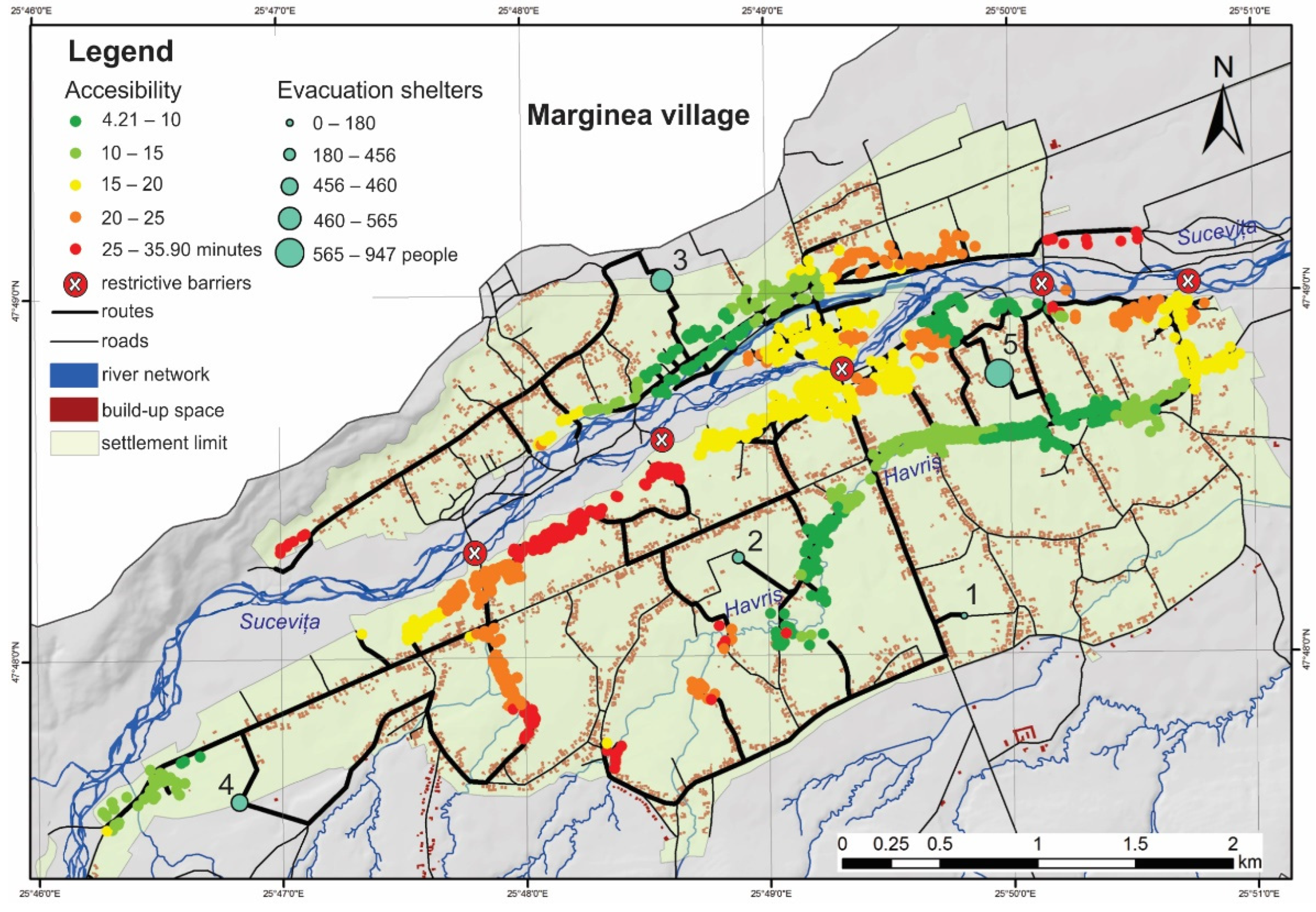
| Evacuation Point | Persons | Travel Time (Min) |
|---|---|---|
| 1 | 180 | 11–30 |
| 2 | 456 | 4.2–35.9 |
| 3 | 460 | 5–32 |
| 4 | 565 | 7–34 |
| 5 | 947 | 4–27.58 |
Publisher’s Note: MDPI stays neutral with regard to jurisdictional claims in published maps and institutional affiliations. |
© 2022 by the authors. Licensee MDPI, Basel, Switzerland. This article is an open access article distributed under the terms and conditions of the Creative Commons Attribution (CC BY) license (https://creativecommons.org/licenses/by/4.0/).
Share and Cite
Chelariu, O.-E.; Iațu, C.; Minea, I. A GIS-Based Model for Flood Shelter Locations and Pedestrian Evacuation Scenarios in a Rural Mountain Catchment in Romania. Water 2022, 14, 3074. https://doi.org/10.3390/w14193074
Chelariu O-E, Iațu C, Minea I. A GIS-Based Model for Flood Shelter Locations and Pedestrian Evacuation Scenarios in a Rural Mountain Catchment in Romania. Water. 2022; 14(19):3074. https://doi.org/10.3390/w14193074
Chicago/Turabian StyleChelariu, Oana-Elena, Corneliu Iațu, and Ionuț Minea. 2022. "A GIS-Based Model for Flood Shelter Locations and Pedestrian Evacuation Scenarios in a Rural Mountain Catchment in Romania" Water 14, no. 19: 3074. https://doi.org/10.3390/w14193074
APA StyleChelariu, O.-E., Iațu, C., & Minea, I. (2022). A GIS-Based Model for Flood Shelter Locations and Pedestrian Evacuation Scenarios in a Rural Mountain Catchment in Romania. Water, 14(19), 3074. https://doi.org/10.3390/w14193074