
Genesis and Distribution of Low Fluvial Terraces Formed by Holocene Climate Pulses in Brazil

 ,
,  , , , , , and
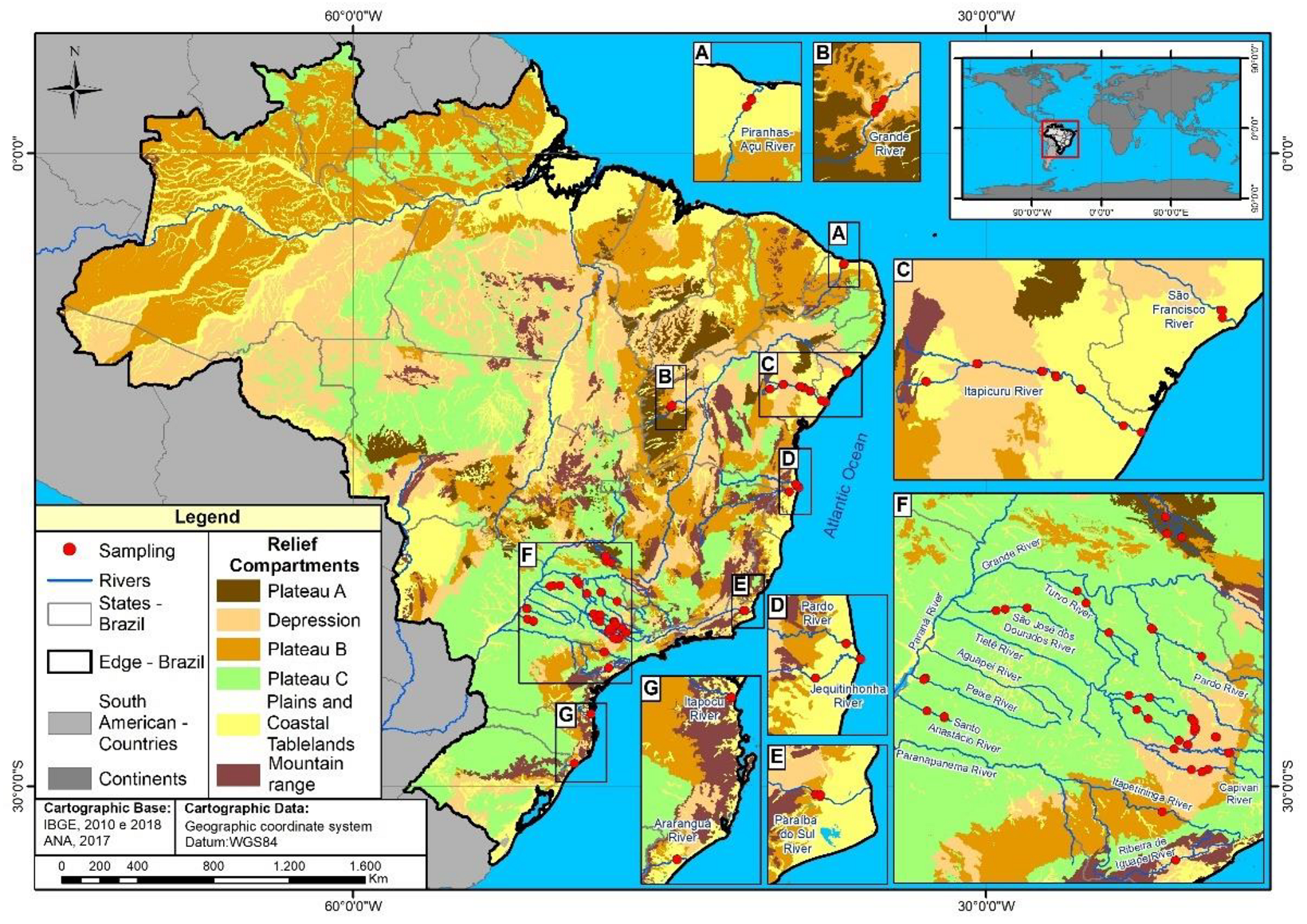
Abstract
1. Introduction
2. Materials and Methods
2.1. Selection and Spatialization of Geochronological Data
2.2. Identification of Low River Terraces
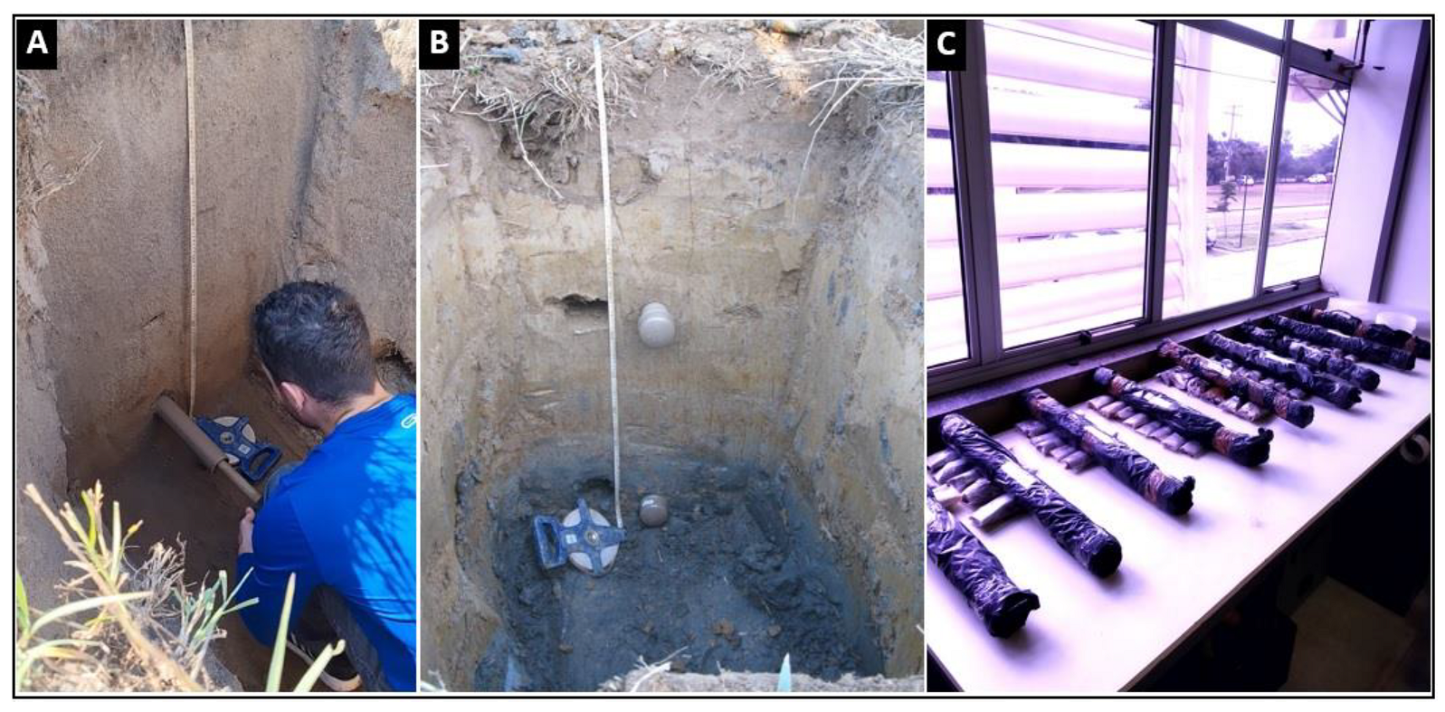
2.3. Optically Stimulated Luminescence (OSL)
2.4. Data Processing and Statistical Correlations
3. Results
3.1. Geomorphic Characterization of Low Terraces
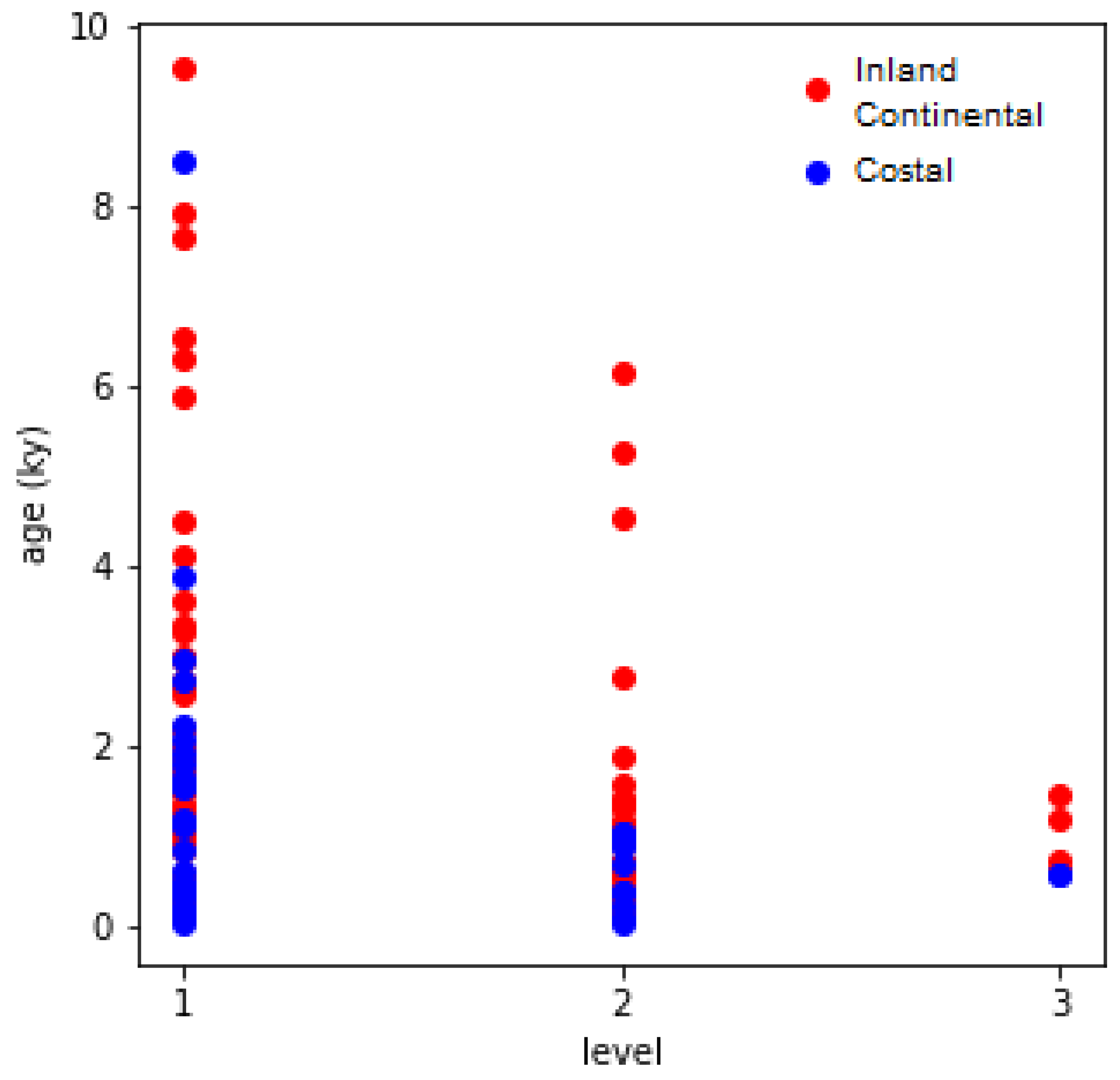
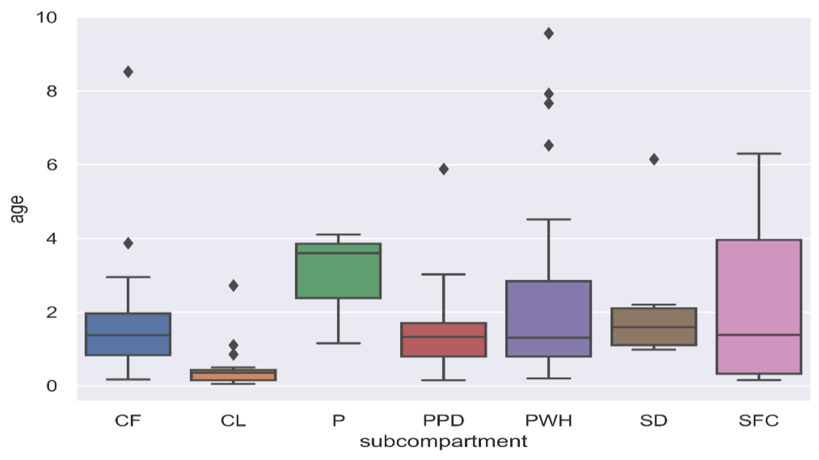
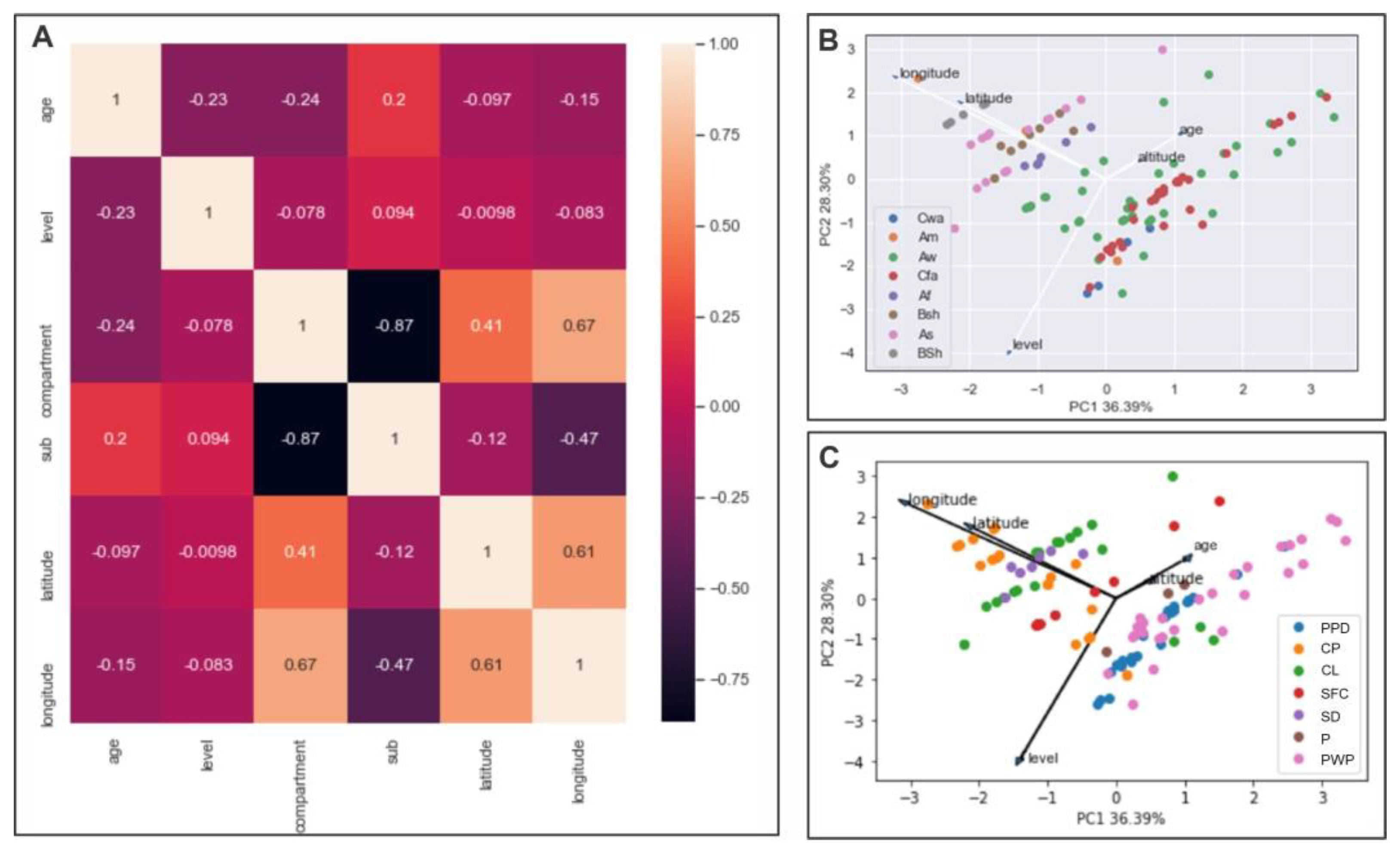
3.2. Statistical Data Analysis
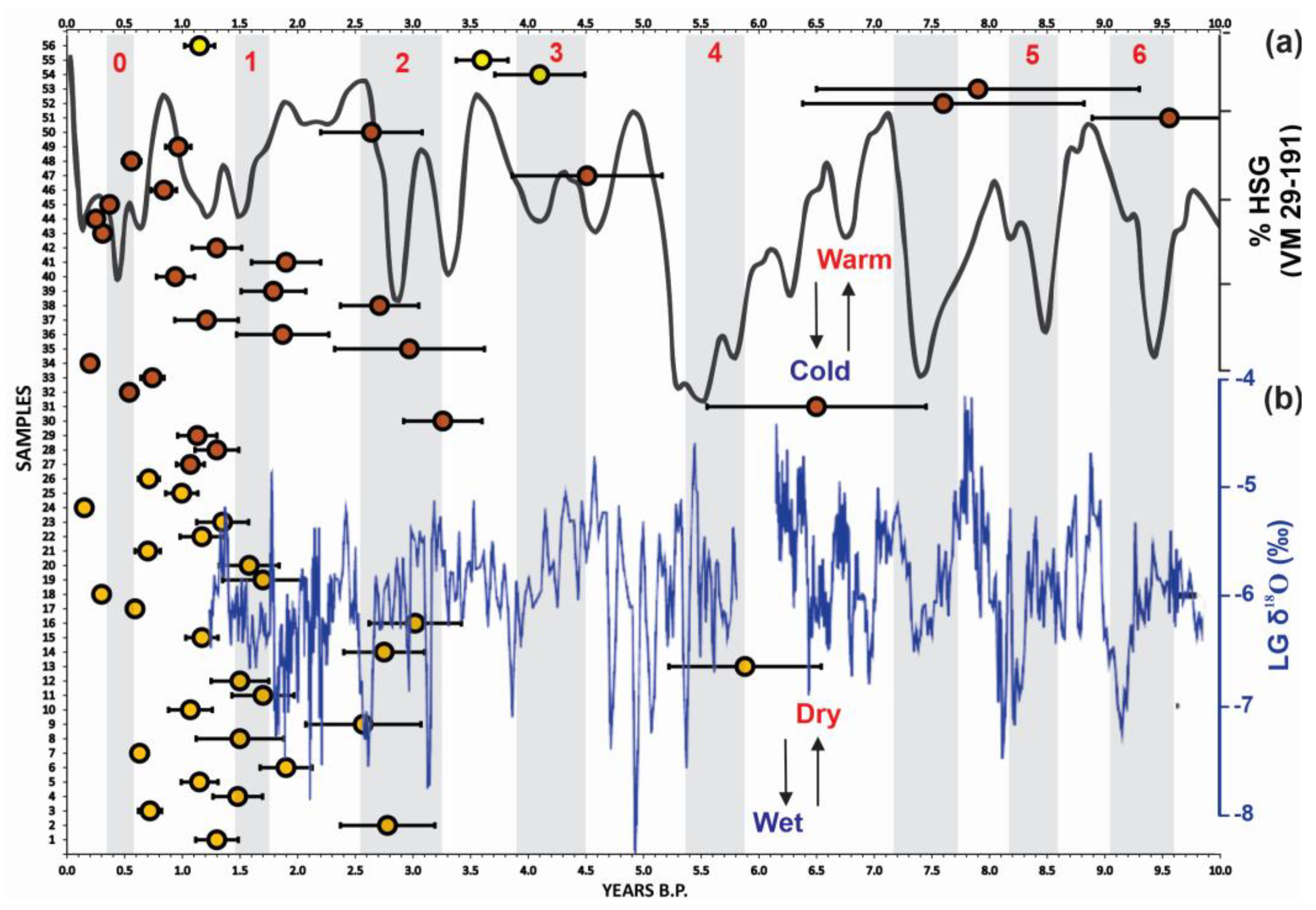
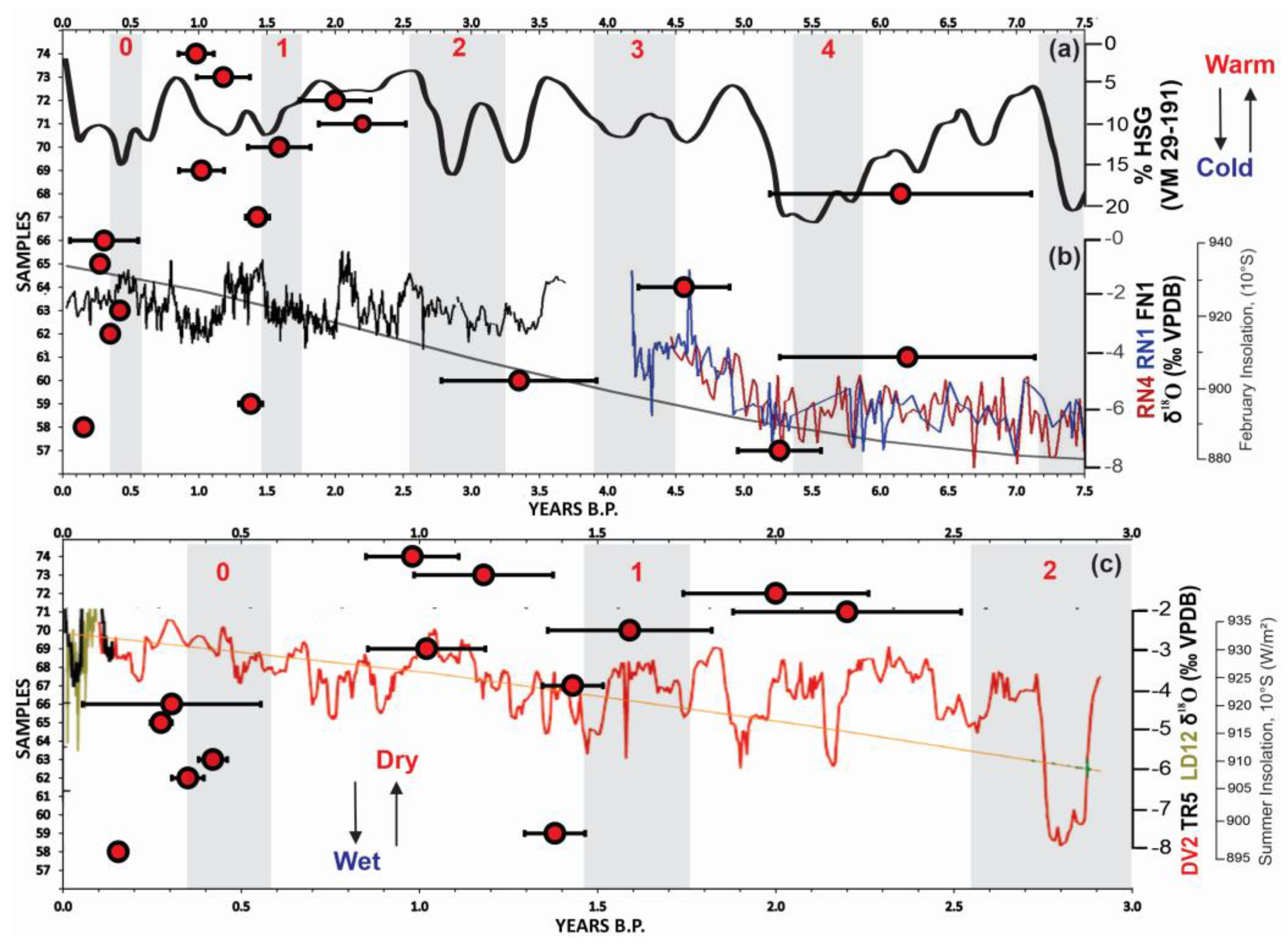
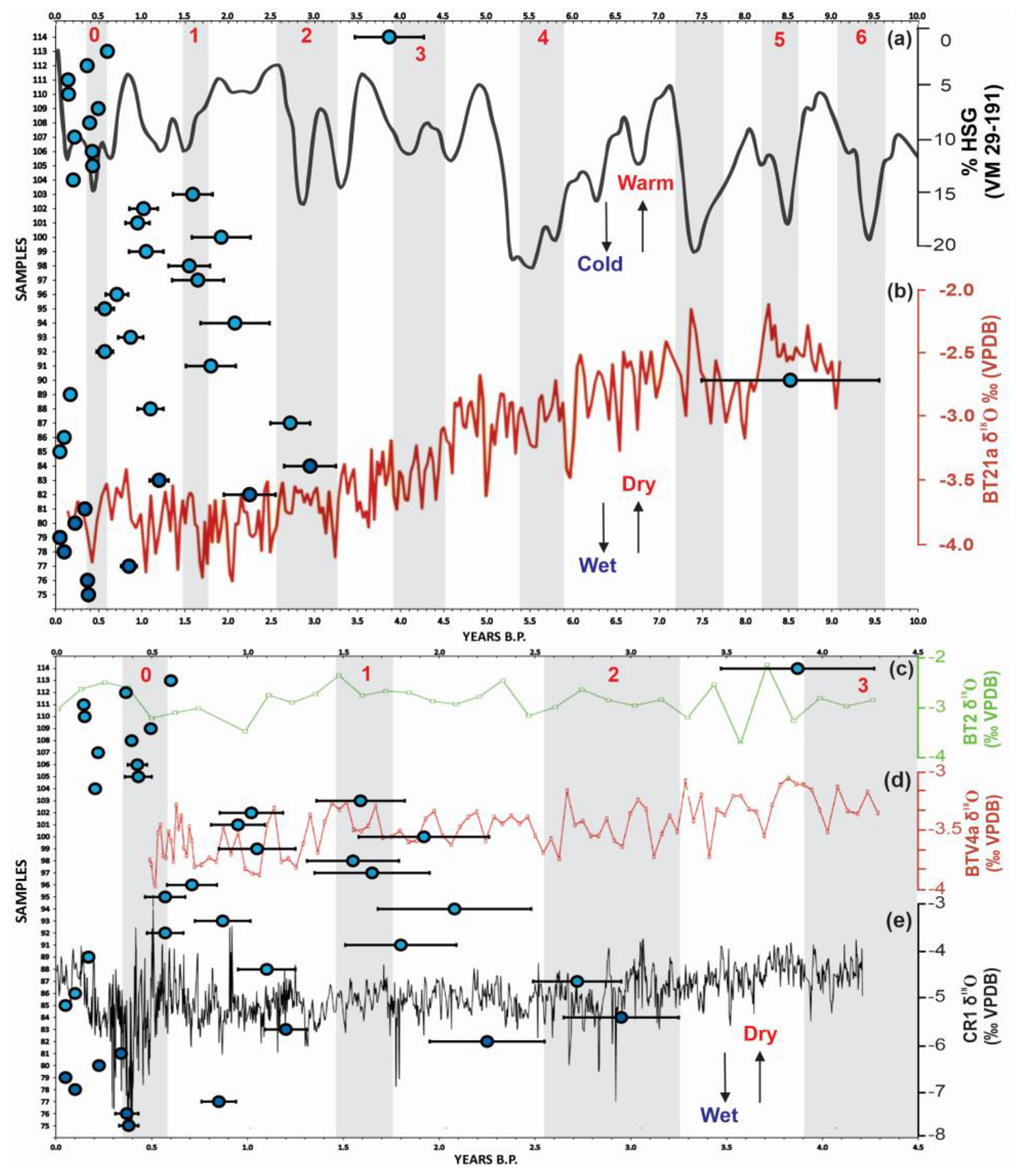
4. Discussion
4.1. Paulista Peripheral Depression, Paulista Western Plateau, and Central Plateau
4.2. Southern Sertaneja Depression of Northeastern Brazil
4.3. Coastal Lowlands and Coastal Plains of the South, Southeast, and Northeast of Brazil
5. Conclusions
Supplementary Materials
Author Contributions
Funding
Institutional Review Board Statement
Informed Consent Statement
Data Availability Statement
Conflicts of Interest
References
- Brunsden, D.; Thornes, J.B. Landscape sensitivity and change. Trans. Inst. Br. Geogr. 1979, 4, 463–484. [Google Scholar] [CrossRef]
- Errico, A.; Lama, G.F.C.; Francalanci, S.; Chirico, G.B.; Solari, L.; Preti, F. Flow dynamics and turbulence patterns in a drainage channel colonized by common reed (Phragmites australis) under different scenarios of vegetation management. Ecol. Eng. 2019, 133, 39–52. [Google Scholar] [CrossRef]
- Lama, G.F.C.; Rillo Migliorini Giovannini, M.; Errico, A.; Mirzaei, S.; Padulano, R.; Chirico, G.B.; Preti, F. Hydraulic Efficiency of Green-Blue Flood Control Scenarios for Vegetated Rivers: 1D and 2D Unsteady Simulations. Water 2021, 13, 2620. [Google Scholar] [CrossRef]
- Phillips, J.D. Sources of nonlinearity and complexity in geomorphic systems. Prog. Phys. Geogr. 2003, 27, 1–23. [Google Scholar] [CrossRef]
- Phillips, J.D. Emergence and pseudo-equilibrium in geomorphology. Geomorphology 2011, 132, 319–326. [Google Scholar] [CrossRef]
- Benito, G.; Machado, M.J.; Pérez-González, A. Climate change and flood sensitivity in Spain. Geol. Soc. Lond. Spec. Publ. 1996, 115, 85–98. [Google Scholar] [CrossRef]
- Boer, D.H. Hierarchies and spatial scale in process geomorphology: A review. Geomorphology 1992, 4, 303–318. [Google Scholar] [CrossRef]
- Fryirs, K. (Dis) Connectivity in catchment sediment cascades: A fresh look at the sediment delivery problem. Earth Surf. Process. Landf. 2012, 38, 30–46. [Google Scholar] [CrossRef]
- Fryirs, K.A. River sensitivity: A lost foundation concept in fluvial geomorphology. Earth Surf. Process. Landf. 2017, 42, 55–70. [Google Scholar] [CrossRef]
- Lama, G.F.C.; Crimaldi, M.; Pasquino, V.; Padulano, R.; Chirico, G.B. Bulk Drag Predictions of Riparian Arundo donax Stands through UAV-acquired Multispectral Images. Water 2021, 13, 1333. [Google Scholar] [CrossRef]
- Lama, G.F.C.; Errico, A.; Francalanci, S.; Solari, L.; Preti, F.; Chirico, G.B. Evaluation of Flow Resistance Models Based on Field Experiments in a Partly Vegetated Reclamation Channel. Geosciences 2020, 10, 47. [Google Scholar] [CrossRef]
- Wohl, E.; Brierley, G.; Cadol, D.; Coulthard, T.J.; Covino, T.; Fryirs, K.A.; Grant, G.; Hilton, R.G.; Lane, S.N.; Magilligan, F.J.; et al. Connectivity as an emergent property of geomorphic systems. Earth Surf. Process. Landf. 2019, 44, 4–26. [Google Scholar] [CrossRef]
- Schumm, S.A. Geomorphic thresholds: The concept and its applications. Trans. Inst. Br. Geogr. 1979, 4, 485–515. [Google Scholar] [CrossRef]
- Schumm, S.A.; Lichty, R.W. Time, space, and causality in geomorphology. Am. J. Sci. 1965, 263, 110–119. [Google Scholar] [CrossRef]
- Bond, G.; Kromer, B.; Beer, L.; Muscheler, R.; Evans, M.N.; Showers, W.; Hoffmann, S.; Lotti-Bond, R.; Hajdas, I.; Bonani, G. Persistent solar influence on North Atlantic climate during the Holocene. Science 2001, 294, 2130–2136. [Google Scholar] [CrossRef]
- Bradley, R.S.; Hughes, M.K.; Diaz, H.F. Climate in medieval time. Science 2003, 302, 404–405. [Google Scholar] [CrossRef]
- Vandenberghe, J. Timescales, climate and river development. Quat. Sci. Rev. 1995, 14, 631–638. [Google Scholar] [CrossRef]
- Vandenberghe, J. Climate forcing of fluvial system development: An evolution of ideas. Quat. Sci. Rev. 2003, 22, 2053–2060. [Google Scholar] [CrossRef]
- Thomas, M.F. Landscape sensitivity in time and space—An introduction. Catena 2001, 42, 83–98. [Google Scholar] [CrossRef]
- Breda, C.; Pupim, F.N.; Sawakuchi, A.O.; Mineli, T.D. The role of bedrock and climate for the late Quaternary erosive-depositonal behavior of an intraplate tropical river: The Tietê River case, southeastern Brazil. Geomorphology 2021, 389, 107834. [Google Scholar] [CrossRef]
- Cruz, F.W.; Vuille, M.; Burns, S.J.; Wang, X.; Cheng, H.; Werner, M.; Edwards, R.L.; Karmann, I.; Auler, A.S.; Nguyen, H. Orbitally driven east-west antiphasing of South American precipitation. Nat. Geosci. 2009, 2, 210–214. [Google Scholar] [CrossRef]
- Butzer, K.W. Holocene alluvial sequences: Problems of dating and correlation. Timescales Geomorphol. 1980, 131–142. [Google Scholar]
- Taylor, M.P.; Macklin, M.G.; Hudson-Edwards, K. River sedimentation and fluvial response to Holocene environmental change in the Yorkshire Ouse Basin, northern England. Holocene 2000, 10, 201–212. [Google Scholar] [CrossRef]
- Macklin, M.G.; Lewin, J. River sediments, great floods and centennial-scale Holocene climate change. J. Quat. Sci. 2003, 18, 101–105. [Google Scholar] [CrossRef]
- Macklin, M.G.; Jones, A.F.; Lewin, J. River response to rapid Holocene environmental change: Evidence and explanation in British catchments. Quat. Sci. Rev. 2010, 29, 1555–1576. [Google Scholar] [CrossRef]
- Macklin, M.G.; Lewin, J.; Jones, A.F. River entrenchment and terrace formation in the UK Holocene. Quat. Sci. Rev. 2013, 76, 194–206. [Google Scholar] [CrossRef]
- Dias, R.L. Geocronologia Da Cobertura Superficial Em Níveis Geomorfológicos Do Setor Centro-Ocidental Na Depressão Periférica Paulista. Ph.D. Thesis, Universidade Estadual de Campinas, São Paulo, Brazil, 2015. [Google Scholar]
- Haug, G.H.; Hughen, K.A.; Sigman, D.M.; Peterson, L.C.; Röhl, U. Southward migration of the intertropical convergence zone through the Holocene. Science 2001, 293, 1304–1308. [Google Scholar] [CrossRef]
- Latrubesse, E.M.; Stevaux, J.C.; Sinha, R. Tropical rivers. Geomorphology 2005, 70, 187–206. [Google Scholar] [CrossRef]
- Sinha, R.; Jain, V.; Babu, G.P.; Ghosh, S. Geomorphic characterization and diversity of the fluvial systems of the Gangetic Plains. Geomorphology 2005, 70, 207–225. [Google Scholar] [CrossRef]
- Leli, I.T.; Stevaux, J.C.; Assine, M.L. Origin, evolution, and sedimentary records of islands in large anabranching tropical rivers: The case of the Upper Paraná River, Brazil. Geomorphology 2020, 358, 107118. [Google Scholar] [CrossRef]
- Khan, M.A.; Sharma, N.; Lama, G.F.C.; Hasan, M.; Garg, R.; Busico, G.; Alharbi, R.S. Three-Dimensional Hole Size (3DHS) Approach for Water Flow Turbulence Analysis over Emerging Sand Bars: Flume-Scale Experiments. Water 2022, 14, 1889. [Google Scholar] [CrossRef]
- Dias, R.L.; Perez Filho, A. Geocronologia de terraços fluviais na bacia hidrográfica do rio Corumbataí-SP a partir de Luminescência Opticamente Estimulada (LOE). Rev. Bras. Geomorfol. 2015, 16, 341–349. [Google Scholar] [CrossRef]
- Storani, D.L. Cenário Regional das Oscilações Climáticas Quaternárias: Baixos Terraços Fluviais no Contexto da Depressão Periférica e do Planalto Ocidental Paulista. Ph.D. Thesis, Universidade Estadual de Campinas, São Paulo, Brazil, 2015; 104p. [Google Scholar]
- Valezio, E.V.; Perez Filho, A. Dinâmica antrópica no canal fluvial do córrego Tucum–São Pedro, São Paulo (Brasil). Rev. Bras. Geomorfol. 2016, 16, 545–557. [Google Scholar] [CrossRef][Green Version]
- Rubira, F.G.; Perez Filho, A. Geochronology and hydrodynamic energy conditions in surface coverings of low Holocene fluvial, fluvialmarine, and marine terraces: Climatic pulsations to the south of the Aranguaguá River Basin (SC). Rev. Bras. Geomorfol. 2018, 19, 635–663. [Google Scholar] [CrossRef]
- Souza, A.O.; Perez Filho, A. Processos, ambientes deposicionais e geocronológicas das coberturas superficiais sobre aplainamentos neogênicos e terraços fluviais na bacia do Ribeirão Araquá, Depressão Periférica Paulista. Rev. Bras. Geomorfol. 2018, 19, 107–126. [Google Scholar] [CrossRef]
- Souza, A.O.; Perez Filho, A. Late Holocene coastal dynamics, climate pulses and low terraces in the coast of the state of São Paulo, southeast, Brazil. J. S. Am. Earth Sci. 2019, 92, 234–245. [Google Scholar] [CrossRef]
- Perez Filho, A.; Rubira, F.G. Evolutionary interpretation of Holocene landscapes in eastern Brazil by optimally stimulated luminescence: Surface coverings and climatic pulsations. Catena 2019, 172, 866–876. [Google Scholar] [CrossRef]
- Moreira, V.B.; Perez Filho, A. Geocronologia da cobertura superficial em baixos terraços fluviais na chapada Uberlândia-Uberaba/MG. Rede Rev. Eletrônica Prodema 2019, 13, 89–100. [Google Scholar] [CrossRef]
- Rasbold, G.G.; Mcglue, M.M.; Stevaux, J.C.; Parolin, M.; Silva, A.; Bergier, I. Sponge spicule and phytolith evidence for Late Quaternary environmental changes in the tropical Pantanal wetlands of western Brazil. Palaeogeogr. Palaeoclimatol. Palaeoecol. 2019, 518, 119–133. [Google Scholar] [CrossRef]
- Lima, K.C.; Perez Filho, A.; Lupinacci, C.M.; Valezio, É.V.; Góes, L.M. Fluvial responses to external and internal forcing: Upper Holocene dynamics in a low latitude semi-arid region in South America. J. S. Am. Earth Sci. 2021, 112, 103545. [Google Scholar] [CrossRef]
- Souza, A.O.; Lämmle, L.; Perez Filho, A.; Donadio, C. Recent geomorphological changes in the Paraiba do Sul delta, South America East Coast. Prog. Phys. Geogr. 2022, 46, 566–588. [Google Scholar] [CrossRef]
- Lämmle, L.; Perez Filho, A.; Donadio, C.; Moreira, V.B.; Santos, C.J.; Souza, A.O. Baixos terraços marinhos associados às transgressões e regressões marinhas holocênicas na Planície Costeira do rio Paraíba do Sul, Rio de Janeiro, Brasil. Rev. Bras. Geomorfol. 2022, 23, 1285–1303. [Google Scholar] [CrossRef]
- Wanner, H.; Solomina, O.; Grosjean, M.; Ritz, S.P.; Jetel, M. Structure and origin of Holocene cold events. Quat. Sci. Rev. 2011, 30, 3109–3123. [Google Scholar] [CrossRef]
- Kennett, D.J.; Breitenbach, S.F.; Aquino, V.V.; Asmeron, Y.; Awe, J.; Baldini, J.U.L.; Bartlein, P.; Culleton, B.J.; Ebert, C.; Jazwa, C.; et al. Development and disintegration of Maya political systems in response to climate change. Science 2012, 338, 788–791. [Google Scholar] [CrossRef] [PubMed]
- Walker, M.; Head, M.J.; Berkelhammer, M.; Björck, S.; Cheng, H.; Cwynar, L.; Fisher, D.; Gkinis, V.; Long, A.; Lowe, J.; et al. Formal ratification of the subdivision of the Holocene Series/Epoch (Quaternary System/Period): Two new Global Boundary Stratotype Sections and Points (GSSPs) and three new stages/subseries. Episodes 2018, 41, 213–223. [Google Scholar] [CrossRef]
- Koch, A.; Brierley, C.; Maslin, M.M.; Lewis, S.L. Earth system impacts of the European arrival and Great Dying in the Americas after 1492. Quat. Sci. Rev. 2019, 207, 13–36. [Google Scholar] [CrossRef]
- Leopold, L.B.; Wolman, M.G.; Miller, J.P. Fluvial Processes in Geomorphology; W. H. Freeman and Company: San Francisco, CA, USA, 1964. [Google Scholar]
- Moy, C.M.; Seltzer, G.O.; Rodbell, D.T.; Anderson, D.M. Variability of El niño/ southern oscillation activity at millennial timescales during the Holocene epoch. Nature 2002, 420, 162. [Google Scholar] [CrossRef] [PubMed]
- Moreira, V.B.; Perez Filho, A. Das superfícies de aplainamento aos pulsos climáticos holocênicos: A evolução da paisagem em relevos de chapada. Soc. Nat. 2020, 32, 176–195. [Google Scholar] [CrossRef]
- Souza, A.O.; Perez Filho, A.; Lämmle, L.; Souza, D.H. Holocene climate pulses and structural controls on the geomorphological estuarine evolution of The Iguape River, São Paulo, Brazil. Cont. Shelf Res. 2020, 205, 104168. [Google Scholar] [CrossRef]
- Ljungqvist, F.C. A new reconstruction of temperature variability in the extra-tropical Northern Hemisphere during the last two millennia. Geogr. Ann. Ser. A Phys. Geogr. 2010, 92, 339–351. [Google Scholar] [CrossRef]
- Bond, G.; Showers, W.; Cheseby, M.; Lotti, R.; Almasi, P.; Menocal, P.; Priore, P.; Cullen, H.; Hajdas, I.; Bonani, G. A pervasive millennial-scale cycle in the North Atlantic Holocene and glacial climates. Science 1997, 278, 1257–1266. [Google Scholar] [CrossRef]
- Bahr, A.; Kaboth-Bahr, S.; Jaeschke, A.; Chiessi, C.; Cruz, F.; Carvalho, L.; Rethemeyer, J.; Schefuß, E.; Geppert, P.; Alburquerque, A.L.; et al. Late Holocene Precipitation Fluctuations in South America Triggered by Variability of the North Atlantic Overturning Circulation. Paleoceanogr. Paleoclimatol. 2021, 36, e2021PA004223. [Google Scholar] [CrossRef]
- Behling, H. Late Quaternary vegetational and climatic changes in Brazil. Rev. Palaeobot. Palynol. 1998, 99, 143–156. [Google Scholar] [CrossRef]
- Behling, H. South and southeast Brazilian grasslands during Late Quaternary times: A synthesis. Palaeogeogr. Palaeoclimatol. Palaeoecol. 2002, 77, 19–27. [Google Scholar] [CrossRef]
- Pessenda, L.C.R.; Saia, S.E.M.G.; Gouveia, S.E.M.; Ledru, M.P.; Sifeddine, A.; Amaral, P.G.C.; Bendassolli, J.A. Last millennium environmental changes and climate inferences in the Southeastern Atlantic forest, Brazil. An. Acad. Bras. Ciências 2010, 82, 717–729. [Google Scholar] [CrossRef]
- Vuille, M.; Burns, S.J.; Taylor, B.L.; Cruz, F.W.; Bird, B.W.; Abbott, M.B.; Kanner, L.C.; Cheng, H.; Novello, V.F. A review of the South American monsoon history as recorded in stable isotopic proxies over the past two millennia. Clim. Past 2012, 8, 1309–1321. [Google Scholar] [CrossRef]
- Novello, V.F.; Cruz, F.W.; Karmann, I.; Burns, S.J.; Stríkis, N.M.; Vuille, M.; Cheng, H.; Edwards, R.L.; Santos, R.V.; Frigo, E.; et al. Multidecadal climate variability in Brazil’s Nordeste during the last 3000 years based on speleothem isotope records. Geophys. Res. Lett. 2012, 39, 1–6. [Google Scholar] [CrossRef]
- Pazzaglia, F.J. Fluvial Terraces. In Treatise on Geomorphology; Academic Press: Cambridge, MA, USA, 2013; Volume 9, pp. 379–412. [Google Scholar]
- Vandenberghe, J. River terraces as a response to climatic forcing: Formation processes, sedimentary characteristics and sites for human occupation. Quat. Int. 2015, 370, 3–11. [Google Scholar] [CrossRef]
- Perez Filho, A.; Donezelli, J.L.; Lepsch, I.F. Relação Solos Geomorfologia em Várzea Do Rio Moji-Guaçu (SP). Rev. Bras. Ciência Solo 1980, 4, 181–187. [Google Scholar]
- de Mello Araujo, A.G.; Feathers, J.K.; Hartmann, G.A.; Ladeira, F.S.; Valezio, É.V.; Nascimento, D.L.; Ricci, O.; Marum, V.J.O.; da Trindade, R.I.F. Revisiting Alice Boer: Site formation processes and dating issues of a supposedly pre-Clovis site in Southeastern Brazil. Geoarchaeology 2020, 37, 32–58. [Google Scholar] [CrossRef]
- Lu, H.; Zhang, H.; Wang, S.J.; Cosgrove, R.; Sun, X.; Zhao, J.; Sun, D.; Zhao, C.; Shen, C.; Wei, M. Multiphase timing of hominin occupations and the paleoenvironment in Luonan Basin, Central China. Quat. Res. 2011, 76, 142–147. [Google Scholar] [CrossRef]
- Panin, A.V.; Nefedov, V.S. Analysis of variations in the regime of river and lakes in the Upper Volga and Upper Zapadnaya Dvina based on archaeological-geomorphological data. Water Resour. 2010, 37, 16–32. [Google Scholar] [CrossRef]
- Silva, V.A. Geomorfologia Antropogênica: Mudanças no Padrão de Drenagem do Canal Principal e Delta, no Baixo Curso da Bacia Hidrográfica do Rio Jequitinhonha/BA. 186p. Ph.D. Thesis, Universidade Estadual de Campinas, São Paulo, Brazil, 2012. [Google Scholar]
- Valezio, E.V. Equilíbrio em Geomorfologia: Geossistemas, Planícies de Inundação e Morfodinâmica dos Rios Jacaré-Pepira e Jacaré-Guaçu (SP). Master’s Thesis, Universidade Estadual de Campinas, São Paulo, Brazil, 2016; 110p. [Google Scholar]
- Lima, K.C. O Holoceno Superior na Bacia do rio Itapicuru (Bahia/Brasil): Proposição de Cenário Para o Baixo Curso e Planície Costeira. Ph.D. Thesis, Universidade Estadual de Campinas, São Paulo, Brazil, 2017. [Google Scholar]
- Moreira, V.B. Geocronologia em Ambientes de Veredas e Campos de Murundus na Chapada Uberlândia-Uberaba: Subsídios à Evolução da Paisagem. Master’s Thesis, Universidade Estadual de Campinas, São Paulo, Brazil, 2017. [Google Scholar]
- Rodrigues, G.B. Geocronologia das Coberturas Superficiais em Baixos Terraços e na Foz da Bacia Hidrográfica do Rio Jequitinhonha (BA) Relacionada Com as Oscilações Climáticas do Holoceno. Master’s Thesis, Universidade Estadual de Campinas, São Paulo, Brazil, 2018. [Google Scholar]
- Goes, L.M. Geocronologia das Coberturas Superficiais nos Baixos Terraços Fluviais e Aluviões Recentes no Médio Curso da Bacia Hidrográfica do Rio Itapicuru (Bahia-Brasil). Ph.D. Thesis, Universidade Estadual de Campinas, São Paulo, Brazil, 2019. [Google Scholar]
- Rubira, F.G. Espacialização e Geocronologia das Coberturas Superficiais em Baixos Terraços Marinhos, Fluviomarinhos e Fluviais na foz das Bacias dos Rios Itapocu e Araranguá (SC), Decorrentes dos Episódios Eustáticos Associados às Oscilações climáticas. Ph.D. Thesis, Universidade Estadual de Campinas, São Paulo, Brazil, 2019. [Google Scholar]
- Moreira, V.B. Geocronologia de Coberturas Superficiais em Baixos Terraços na Foz dos Rios Una/Pardo (BA), Relacionados a Transgressões e Regressões Marinhas Decorrentes de Pulsações Climáticas Holocênicas. Ph.D. Thesis, Universidade Estadual de Campinas, São Paulo, Brazil, 2021. [Google Scholar]
- Souza, A.O. Geocronologia das Coberturas Superficiais em Baixos Terraços Fluviais, Marinhos e Fluvio-Marinhos na Foz das Bacias do Ribeira de Iguape-SP e do Rio Paraíba do Sul-RJ: Flutuações Climáticas Holocênicas no Sudeste Brasileiro. Ph.D. Thesis, Universidade Estadual de Campinas, São Paulo, Brazil, 2019. [Google Scholar]
- Rubira, F.G.; Perez Filho, A. Geocronologia De Eventos Deposicionais Associados Às Coberturas Superficiais Que Sustentam E Recobrem Níveis De Terraços Marinhos Pleistocênicos E Holocênicos No Litoral Sul De Santa Catarina (SC). Rev. Bras. Geomorfol. 2019, 20, 581–602. [Google Scholar] [CrossRef]
- Wintle, A.G.; Murray, A.S. A review of quartz optically stimulated luminescence characteristics and their relevance in single-aliquot regeneration dating protocols. Rations Meas. 2006, 41, 369–391. [Google Scholar] [CrossRef]
- Murray, A.S.; Mejdahl, V. Comparison of regenerative dose single-aliquot and multiple-aliquot protocols using heated quartz from archaeological sites. Quat. Sci. Rev. 1999, 18, 223–229. [Google Scholar] [CrossRef]
- Stríkis, N.M.; Cruz, F.W.; Cheng, H.; Karmann, I.; Edwards, R.L.; Vuille, M.; Wang, X.; Paula, M.S.; Novello, V.F.; Auler, A.S. Abrupt variations in South American monsoon rainfall during the Holocene based on a speleothem record from central-eastern Brazil. Geology 2011, 39, 1075–1078. [Google Scholar] [CrossRef]
- Cheng, H.; Sinha, A.; Wang, X.; Cruz, F.W.; Edwards, R.L. The Global Paleomonsoon as seen through speleothem records from Asia and the Americas. Clim. Dyn. 2012, 39, 1045–1062. [Google Scholar] [CrossRef]
- Zielhofer, C.; Köhler, A.; Mischke, S.; Benkaddour, A.; Mikdad, A.; Fletcher, W.J. Western Mediterranean hydro-climatic consequences of Holocene ice-rafted debris (Bond) events. Clim. Past 2019, 15, 463–475. [Google Scholar] [CrossRef]
- Rubira, F.G.; Perez Filho, A. Evolução das bases teóricas e metodológicas para identificação das mudanças, oscilações e pulsações climáticas. Rev. Bras. Geomorfol. 2021, 22, 922–966. [Google Scholar] [CrossRef]
- Smith, R.J.; Mayle, F.E. Impact of mid- to late Holocene precipitation changes on vegetation across lowland tropical South America: A paleo-data synthesis. Quat. Res. 2018, 89, 134–155. [Google Scholar] [CrossRef]
- Zular, A.; Utida, G.; Cruz, F.W.; Sawakuchi, A.O.; Wang, H.; Bícego, M.; Giannini, P.C.F.; Rodrigues, S.I.; Garcia, G.P.B.; Vuille, M.; et al. The effects of mid-Holocene fluvio-eolian interplay and coastal dynamics on the formation of dune-dammed lakes in NE Brazil. Quat. Sci. Rev. 2018, 196, 137–153. [Google Scholar] [CrossRef]
- Cruz, F.W.; Burns, S.J.; Karmann, I.; Sharp, W.D.; Vuille, M.; Cardoso, A.O.; Ferrari, J.A.; Dias, P.L.S.; Viana Júnior, O. Insolation-driven changes in atmospheric circulation over the past 116,000 years in subtropical Brazil. Nature 2005, 434, 63–66. [Google Scholar] [CrossRef]
- Bernal, J.P.; Cruz, F.W.; Stríkis, N.M.; Wang, X.; Deininger, M.M.; Catunda, M.C.A.; Ortega-Obregón, C.; Cheng, H.; Edwards, R.L.; Auler, A.S. High-resolution Holocene South American monsoon history recorded by a speleothem from Botuverá Cave, Brazil. Earth Planet. Sci. Lett. 2016, 450, 186–196. [Google Scholar] [CrossRef]
- Wang, X.; Auler, A.S.; Edwards, R.L.; Cheng, H.; Ito, E.; Solheid, M. Interhemispheric anti-phasing of rainfall during the last glacial period. Quat. Sci. Rev. 2006, 25, 3391–3403. [Google Scholar] [CrossRef]
- Taylor, B.L. A Speleothems-Based Highresolution Reconstruction of Climate in Southeastern Brazil over the Past 4,100 years. 97f. Ph.D. Thesis, Department of Geosciences, University of Massachusetts Amherst, Amherst, MA, USA, 2010. [Google Scholar]
- Rodrigues, J.M.; Behling, H.; Giesecke, T. Holocene dynamics of vegetation change in southern and southeastern Brazil is consistent with climate forcing. Quat. Sci. Rev. 2016, 146, 54–65. [Google Scholar] [CrossRef]
- Busico, G.; Buffardi, C.; Ntona, M.M.; Vigliotti, M.; Colombani, N.; Mastrocicco, M.; Ruberti, D. Actual and Forecasted Vulnerability Assessment to Seawater Intrusion via GALDIT-SUSI in the Volturno River Mouth (Italy). Remote Sens. 2021, 13, 3632. [Google Scholar] [CrossRef]
- Freedman, D.; Pisani, R.; Purves, R. Statistics: Fourth International Student Edition 2021; W. W. Norton & Company: New York, NY, USA, 2021; Available online: https://www.amazon.com/Statistics-Fourth-International-Student-Freedman/dp/0393930432 (accessed on 18 September 2022).


Publisher’s Note: MDPI stays neutral with regard to jurisdictional claims in published maps and institutional affiliations. |
© 2022 by the authors. Licensee MDPI, Basel, Switzerland. This article is an open access article distributed under the terms and conditions of the Creative Commons Attribution (CC BY) license (https://creativecommons.org/licenses/by/4.0/).
Share and Cite
Perez Filho, A.; Moreira, V.B.; Lämmle, L.; Souza, A.O.; Torres, B.A.; Aderaldo, P.I.C.; Valezio, É.V.; Machado, D.O.B.F.; Prebianca, M.M.; Mazoni, A.F.; et al. Genesis and Distribution of Low Fluvial Terraces Formed by Holocene Climate Pulses in Brazil. Water 2022, 14, 2977. https://doi.org/10.3390/w14192977
Perez Filho A, Moreira VB, Lämmle L, Souza AO, Torres BA, Aderaldo PIC, Valezio ÉV, Machado DOBF, Prebianca MM, Mazoni AF, et al. Genesis and Distribution of Low Fluvial Terraces Formed by Holocene Climate Pulses in Brazil. Water. 2022; 14(19):2977. https://doi.org/10.3390/w14192977
Chicago/Turabian StylePerez Filho, Archimedes, Vinícius B. Moreira, Luca Lämmle, André O. Souza, Bruno A. Torres, Pedro I. C. Aderaldo, Éverton V. Valezio, David O. B. F. Machado, Mateus M. Prebianca, Alysson F. Mazoni, and et al. 2022. "Genesis and Distribution of Low Fluvial Terraces Formed by Holocene Climate Pulses in Brazil" Water 14, no. 19: 2977. https://doi.org/10.3390/w14192977
APA StylePerez Filho, A., Moreira, V. B., Lämmle, L., Souza, A. O., Torres, B. A., Aderaldo, P. I. C., Valezio, É. V., Machado, D. O. B. F., Prebianca, M. M., Mazoni, A. F., Zabini, C., & Rubira, F. G. (2022). Genesis and Distribution of Low Fluvial Terraces Formed by Holocene Climate Pulses in Brazil. Water, 14(19), 2977. https://doi.org/10.3390/w14192977