1. Introduction
It is of paramount importance to emphasize that water is a vital natural resource and is an indispensable component for the maintenance of livelihood on Earth. There are various primary sectors of water consumption, i.e., domestic, agriculture, industry, etc. However, the combination between a deficiency in rainfall and increased human water demand is the major cause of any drought, which can affect most seasonally dry areas recurrently and severely. This corresponds to the findings presented in the IPCC 6th Assessment Report (AR6); the increasing frequency of rainfall deficits in South East Asia was projected based on the increasing frequency of extreme weather events such as droughts triggered by El Nino and anthropogenic effects of climate change [
1]. Therefore, addressing future climate shifts in both rainfall patterns and increases in temperature is challenging especially for climate change and biodiversity hotspots since they are two major components of ongoing climate change [
2,
3]. As with most other parts of Thailand, the northeastern part of Thailand (henceforth referred to as the Northeast) is being affected by droughts almost every year [
4,
5,
6]. Drought leads to a crop water shortage, wilt, desiccation, growth retardation, poor quality of crop yield, etc., and conditions could worsen if a more extensive dry spell continues. The expansion of agricultural areas for both irrigated and non-irrigated fields is also the cause of water shortage and drought, which induces a higher water demand. The expansion clearly resulted in the forest cover loss in the Northeast, as indicated by the observation of the Office of the National Economic and Social Development Council [
7], which is a key contributor to human-caused climate change. Consequently, the projected changes in temperature and rainfall are likely to affect the crop productivity and crop water demand. This reflects the fact that afforestation is considered to be a readily available mitigation option to potentially limit climate change to the lowest possible levels, as stated by Doelman et al., 2020 [
8]. The drought effects on domestic and agriculture are becoming more severe and persistent in some provinces in the Lower Northeast, i.e., Buriram, Surin, and Sisaket, due to a lack of large reservoir storage sites and low rainfall [
9]. Likewise, some parts of the Lam Takong River Basin within the boundary of Nakhon Ratchasima Province have also suffered from drought every year due to the insufficient storage of the Lam Takong Reservoir, especially during the rainy season of 2019, which has 30% less rainfall compared to the average rainfall of the same period between 1997 and 2019. As a result, the inflow to the Lam Takong Reservoir during the rainy season of 2019 was found to be the lowest; the storage to be managed was about 18.9 million m
3, decreasing from its average value of 30–40 million m
3 [
10]. Together with the increase in population, the pressure on land utilization and water demand is on the rise, leading to problems related to land use change and water shortage during the dry season [
11]. In addition, the change in climate, which affects the spatial and temporal changes in the water budget, is also likely to result in crop yield and production instability [
12].
Several studies were undertaken corresponding to the previously mentioned concerns. Al-Bakri et al., 2013 [
13], investigated the impact of climate change and land use change on water resources and food security in Jordan. The crop production using crop simulation process-oriented and statistical models and water resources under anticipated climate change and population growth was considered, in which the changes in land use from cultivated land to urbanization were detected using remote sensing data. The results revealed that the decrease in irrigated areas would lead to less food production and food security, while the agricultural water demand is projected to be increased as a result of increased air temperature and reduced rainfall by the years 2030 and 2050. Koch et al. (2015) [
14] analyzed the changes in land use patterns derived by the open-source land system model MAgPIE, agricultural production, and climate, and their effects on water demand and availability in the São Francisco River Basin (Brazil) using the mesoscale ecohydrological Soil and Water Integrated Model (SWIM), in which the global driver of population growth, economic development, and trade liberalization were taken into consideration. It was found that under the A2 climate scenario, cropland area in the São Francisco River Basin almost doubles until 2035 compared to 2005 at the expense of natural vegetation, whereas under scenario B1, with large nature conservation areas, the size of the cropland area does not change. In addition, under both scenarios, the crop mix changes, in which irrigated sugar cane increases mainly because of increased demand and favorable conditions. Lastly, based on a wetter future climate with wetter rainy seasons and drier dry seasons during 2021–2050, the water availability for irrigated agriculture is high, while hydropower generation declines by 3.2% and 1.7% for the A2 and B1 climate scenarios, respectively, as compared to the reference (1984–2003). Wiberg et al. (2017) [
15] assessed the impacts of changes in socioeconomic and climatic conditions on water security through the development of a hydro-economic classification system that aggregates indicators of hydrological challenges and adaptation capacities. Based on the combination of the impacts of changes in climate under two Representative Concentration Pathways (RCPs 4.5 and 6.0) and land use, the estimated increase in irrigation water use in the Asia and Pacific region becomes 14.3% to 19.9% in 2050 and 16.3% to 30.1% in 2080 compared to the base year, 2010. As a result, the total crop production would increase by 30–36% in 2050 and by 46–50% in 2080 compared to 2010. Furthermore, Song et al., 2018 [
16], also estimated the future agricultural water demand in 2030 on Jeju Island under changes in land use extracted from satellite images at 5-year intervals and future climate (RCP 4.5). The trend analysis method during the interval from 1980 to 2014 was employed to characterize the variation in land use in 2030. By multiplying the target area of the water supply excluding the area not in use in the winter season by the basic unit of water demand, the monthly maximum agricultural water demand on Jeju Island was observed in August of 2030 with a subtropical climate, while the total agricultural water demand in 2030 was estimated to be 1,848,010 m
3/day. The above findings are coherent and consistent with the results of other studies, such as those by Knox et al., 2013 [
17], Bisselink et al., 2018 [
18], Afzal and Ragab, 2019 [
19], Afzal et al., 2021 [
20], etc., which can be useful for worthwhile relevant problems for further investigation in the case of the Lam Takong River Basin. Therefore, the main objective of this study was to assess the agricultural water sufficiency based on changes in climate and land use in the Lam Takong River Basin. In this manner, the framework used in this study lies in integrating the new insights from multiple variations and interaction analyses that were not addressed in earlier studies in the Lam Takong River Basin, thus contributing to the novelty of this work. The effects of future climatic and anthropogenic drivers of change were incorporated to further systematize and consolidate findings concerning the growing imbalance between water supply and agricultural demand at the river basin level, where more than 880,000 people reside [
21] and rapid urbanization and intensive farming are more prevalent [
22]. Eventually, the obtained results from this study will be beneficial for the provision of useful insights and guidelines for effective water allocation, which will lead to the sustainable management of water resources in the Lam Takong River Basin.
4. Conclusions
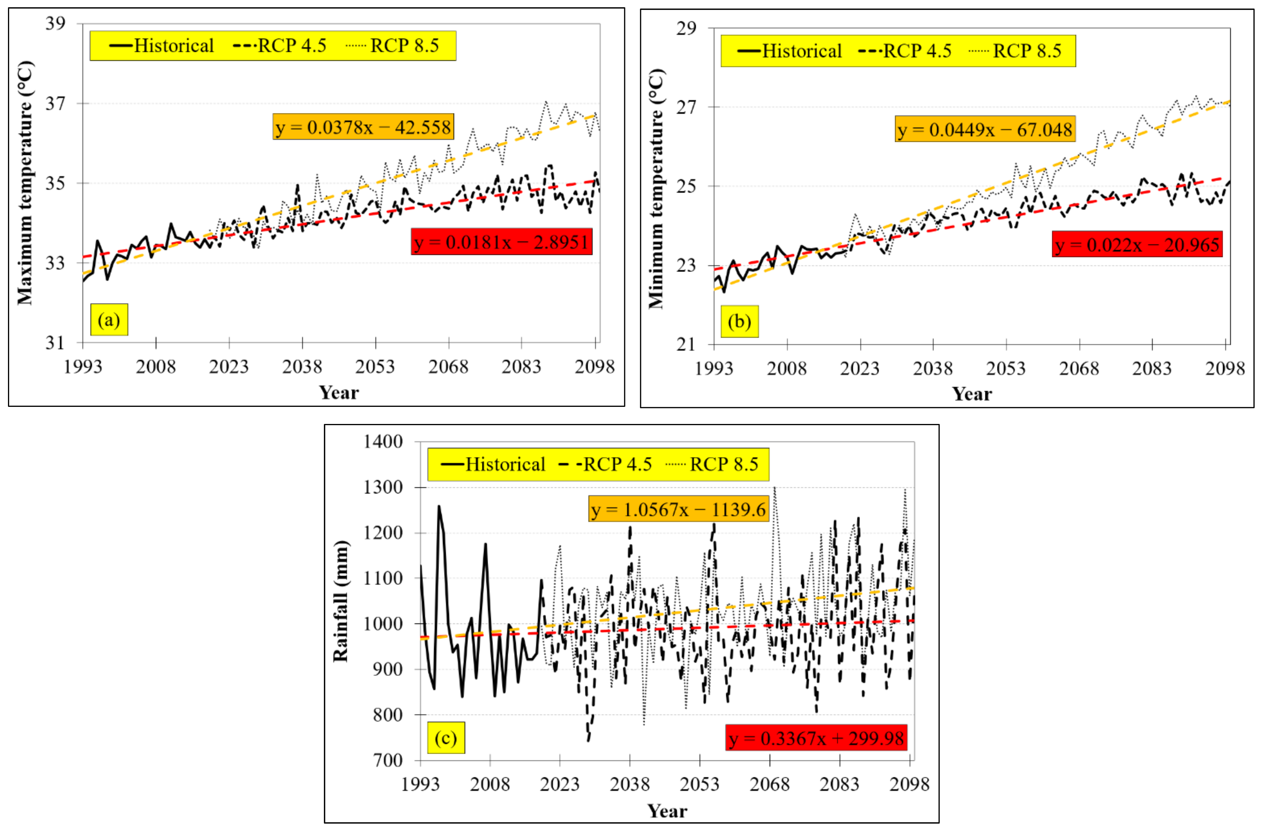
It seems undeniable that climate and land use changes will affect the balance between water availability and agricultural water demand in the Lam Takong River Basin, Thailand. Therefore, we investigated the balance between both aspects and possible consequences. In this context, the possible impacts of climate change on the availability and demand of water for the Lam Takong River Basin were evaluated using three climate models from the Coupled Model Intercomparison Project Phase 5 (CMIP5), namely, IPSL-CM5-MR, NorESM1-M, and CanESM2, for four future periods (2020–2039, 2040–2059, 2060–2079, and 2080–2099). The representative scenarios were the combinations of the three selected climate models run with RCPs 4.5 and 8.5. From the analysis of trends and future projections of climate variables over the Lam Takong River Basin, the future minimum and maximum temperature were predicted to have a statistically significant ascending trend until 2099 under RCPs 4.5 and 8.5. The 80-year average maximum temperature was expected to increase by 0.018 °C/year and 0.038 °C/year under RCPs 4.5 and 8.5, respectively. The future minimum temperature was also found to increase by the rate of 0.022 °C/year and 0.045 °C/year under both RCPs 4.5 and 8.5, respectively. Above the present condition (2019), the 1.76 °C and 1.45 °C increases in future minimum and maximum temperatures, respectively, were estimated to appear in 2099 under RCP 4.5, while the increases of 3.59 °C and 3.02 °C, respectively, were projected for RCP 8.5. The small increase in future rainfall of about 0.34 mm/year was predicted under RCP 4.5, while the projected increase of 1.06 mm/year was determined under RCP 8.5. Comparing to the present year (2019), the increases in future rainfall were observed to be 26.94 mm and 84.54 mm under RCPs 4.5 and 8.5, respectively.
In relation to the historical land use trend, a decrease in agricultural land was observed, while an increase in residential and built-up land and water bodies was detected. When the validation of changes in 2017 was performed with high relative validity (acceptable Overall Accuracy of 86.60% and acceptable Kappa Hat coefficient of 0.78), the CA-Markov model was considered worthy to predict future land use during 2020–2099. By comparing to the 2017 baseline, the uses of land for rice, maize, and cassava cultivation were projected to decline during 2020–2099, while the sugarcane cultivation area showed a growth trend of increasing until 2079 and then declining afterwards. In 2099, the largest increase in land use within the Lam Takong River Basin was found on the use of land for residential and built-up land, while water body area was ranked as the second largest increase in 2099, followed by other agricultural land in 2059. The largest decrease was noted in paddy fields in 2099, while the second largest decrease occurred in the forest category in 2099, followed by the orchard category during 2059–2079.
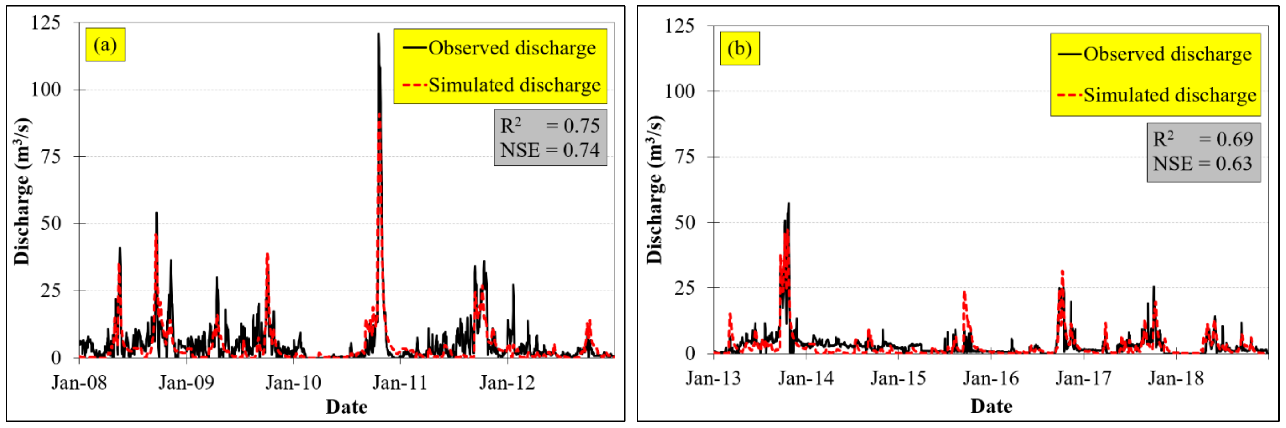
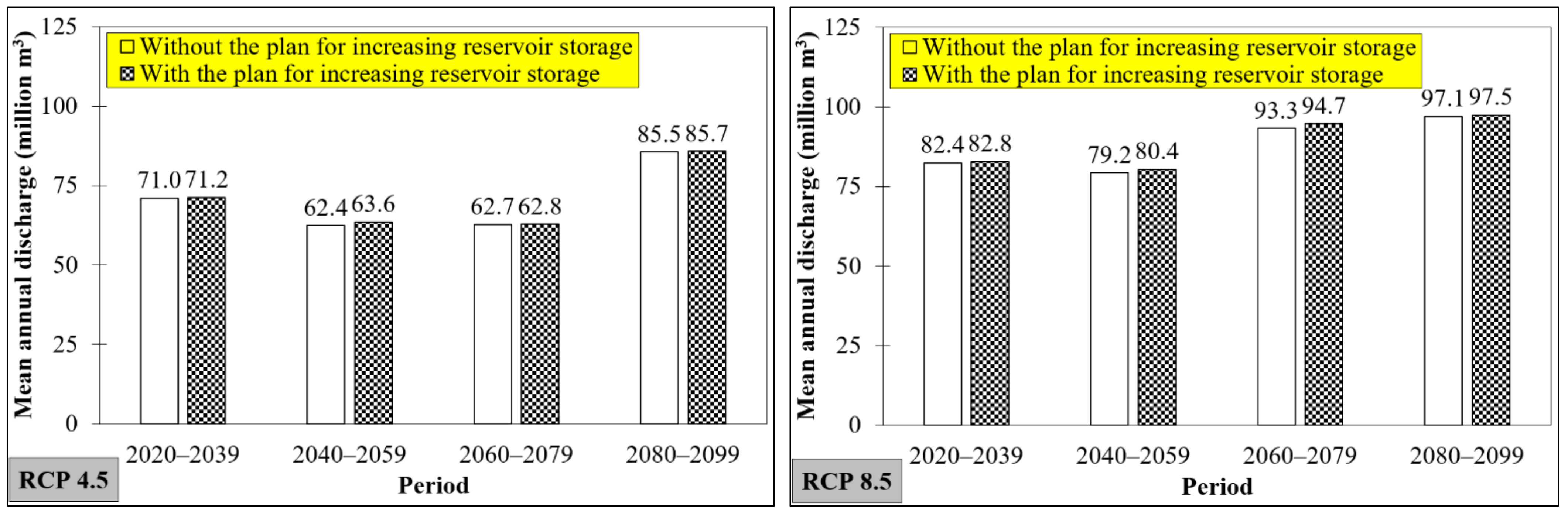
To ascertain water sufficiency, the linkage between water supply (availability) and water demand was explored. The SWAT model was applied for water supply estimation, and its performance was found satisfactory at both calibration and validation stages with values of R2 and NSE higher than 0.6. This indicates that SWAT can accurately simulate hydrological processes in the Lam Takong River Basin under different climate conditions and topography. If implemented with the planned expansion of reservoir storage capacity of 10 million m3, the mean annual discharge as influenced by future climate and land use changes was projected to increase under RCPs 4.5 and 8.5 above the baseline. The biggest mean annual discharge changes were found with increases of 1.2 million m3 and 1.4 million m3 under RCPs 4.5 and 8.5 in the 2040–2059 and 2060–2079 periods, respectively, while the minimum increase was noted as 0.1 million m3 during 2060–2079 under RCP 4.5. Then, the CROPWAT model developed by the FAO was used to analyze the historical agricultural water demand trends in order to confidently determine the future water demand. It was found that cassava would require the highest amount of water, followed by rice, sugarcane, and maize. Under both climate and land use change scenarios, only the future water demand of sugarcane (the highest water demanding crop) under RCP 4.5 was seen to increase from the baseline, while others were not and maize had the lowest water demand among other selected major cash crops. Under RCP 8.5, the water demand of sugarcane and cassava was estimated to increase from the baseline and the rest were projected to decrease, with cassava presenting by far the highest water demand, followed by sugarcane, rice, and maize. Of course, the water demand of all selected cash crops under RCP 4.5 was lower than the RCP 8.5 scenario. It was found that there is a robust signal of water insufficiency or unmet water demand for agriculture during baseline and future periods. When considering baseline conditions, the water availability was found to be limited compared to the needs, especially during June and July, and the deficit was estimated to reach 162.22 million m3/year, varying across the Lam Takong River Basin. Under both RCPs 4.5 and 8.5, the annual water insufficiency was predicted to increase from the baseline in all future scenarios, and the annual unmet water demand was expected to decrease continuously for every 20-year period from 2020 to 2099. Additionally, the minimum future unmet water demand under both RCPs was also observed during 2080–2099, whereas the maximum potential was found during 2020–2039. Clearly, the increase in unmet water demand was observed to be higher under RCP 8.5 compared with RCP 4.5 due to a lesser increase in future rainfall and a lower agricultural water demand of the lower emission scenario of climate change to 2099 (RCP 4.5). However, as the water demand in agriculture and the unmet water demand would expect to increase in all scenarios, a further intensification of pressure on water resources and agriculture would lead to water scarcity in some areas within the Lam Takong River Basin in the near future and onwards.
To confirm the reliability and validity of obtained results of this study, various diagnostic tests were conducted through a comparison between results from the literature, simulations, and theory. Some attained results related to either historical or future changes in rainfall, land use, streamflow, and agricultural water demand and sufficiency were validated with the literature. Moreover, the results gained from the land use prediction model and hydrological process simulations were also validated with the theory of classification accuracy assessment and observed data, respectively, in which the acceptable accuracy criteria were set according to guidelines reported in the literature. The obtained findings under both future climate and land use changes provided insights into the variations in water availability and agricultural water demand, which could lead to more frequent water shortage conditions. Thus, the identification of potential future threats gained from this study could foster better decisions, precise mitigation, and applicable adaptation and resiliency strategies for ensuring water sustainability and security in the Lam Takong River Basin.


